Not with Purple Haze, but with signal interference — although, come to think of it, the two may be not unalike, phenomenologically.
The October reader’s poll asked “Have you directly experienced any of the following? Check all that apply.
GPS/GNSS jamming.
GPS/GNSS spoofing.
Unintentional RF interference.
RF interference from unknown source; unknown whether intentional or not.
None of the above.
Other, please specify.
The answers rather stunned me in their magnitude. To be sure, respondents were self-selected and thus not totally representative of the electorate (you) out there. People who have undergone jamming or spoofing would be much more likely to step forward and say “Yeah, here,” than those who had not would be to fill out an online form, however brief, simply to say “Nah, not me.”
At any rate, the answers came back:
Jamming: 70 percent (70 percent!)
Spoofing: 25 percent
Unintentional RF interference: 55 percent
Unknown RF interference: 65 percent
None of the above: 5 percent
Among the “other” answers we received were these:
I’ve participated in official test activities; Incidents caused by GPS booster (low-cost repeater); We regularly see our vehicle tracking systems jammed or providing incorrect positions believed to be via organised theft using sophisticated jammers; Every time I drive past Newark, NJ on I-95; Badly installed GPS antennas, RF interference from old GPS antennas.
Scanning the affiliations of those answering, the names of organizations actively involved in monitoring or countering jamming and spoofing rise to the top. Still, to get such overwhelming response — only one in 20 was not experienced in this realm — suggests time and energy invested in protections and countermeasures should be doubled, quadrupled or more. Disasters of many kinds loom.
Speaking of disasters, and of our fondness for placing our finger on the pulse of the GNSS/PNT community, we held a mock presidential plebiscite at ION GNSS+ in September. “Who will be the best GPS president?” That is, who would be the best president for GPS, in terms of funding and support? The answers: Clinton 60 percent, Trump 34 percent. The real results may already be known by the time you read this. And, to paraphrase Gerald Ford (something I never thought I’d find myself doing), our long national nightmare may be over.
The protective fairing is lowered onto the four Galileo satellites and their dispenser resting atop an Ariane 5 launcher. The fairing was placed on Nov. 3. (Photo: ESA)
Europe’s next four Galileo navigation satellites are together on their dispenser atop the Ariane 5 launcher due to launch them next Thursday from Europe’s Spaceport in French Guiana.
Having been attached to their dispenser as a combined upper composite, the four 715-kg satellites were transported to the final assembly building on Oct. 31.
The next step saw them put on top of the upper stage of their customized launcher. Finally, on 3 November, the quartet was enclosed within a protective fairing — the last time they were seen by human eyes — to protect them from the onrushing atmosphere during ascent.
In the following week, the rocket was prepared for takeoff, including filling its cryogenic upper stage, in preparation for the move to the launch pad on Tuesday, Nov. 15.
In development since 2012, this new Ariane variant has evolved from the version used to place ESA’s 20 t Automated Transfer Vehicle vehicle into low orbit. The new launcher has to carry a lighter payload but needs to take it up to the much higher altitude of 22 900 km.
Cutaway view shows the four Galileo satellites mounted on top of a specially adapted Ariane 5 rocket underneath the aerodynamic fairing. (Image: ESA)
The target orbit is actually 300 km under the Galileo constellation’s final working altitude. This leaves Ariane’s upper stage in a stable ‘graveyard orbit’, while the four Galileos manoeuvre themselves up to their final set height.
The decision to proceed with this launch was taken after in-depth analysis of two recent anomalies occurring in rubidium atomic clocks aboard Galileo satellites in orbit.
Galileo satellites 15–18, attached to their dispenser, are placed onto their Ariane 5 launcher. (Photo: ESA)
Highly accurate timing is core to satellite navigation. Each Galileo carries four atomic clocks to ensure quadruple redundancy of the timing subsystem: two Passive Hydrogen Maser clocks plus two Rubidium Atomic Frequency Standard (RAFS) clock.
Investigations jointly conducted by ESA and industry point to a short circuit in these two RAFS unit. The ultimate objective of the fourfold redundancy on each satellite is to ensure operations over their planned lifetime.
Taking into account the redundancy and considering that the upcoming launch will increase the constellation’s overall robustness,it has been decided to maintain the mid-November launch date. Once this latest flight is complete, there will be 18 Galileo satellites in orbit — the single largest increase of any navigation satellite constellation from a single launch.
This will mark the first time that ESA deploys four satellites simultaneously. Usually, simply shepherding a spacecraft through the first critical days in orbit is a demanding enough task. A combined team from ESA and France’s CNES space agency based in Toulouse, France, will make contact, establish control and then see the quartet through its initial, critical, activities.
Two further Ariane 5 flights are planned for Galileo during the next two years, one each for the constellation’s remaining orbital planes.
Already above Earth’s atmosphere, Ariane’s aerodynamic fairing is jettisoned and the four Galileo satellites enter space for the first time. (Image: ESA)
The document was issued by the China Satellite Navigation Office. It defines the specification related to open service signals B1I and B2I between the space segment and the user segment of the BeiDou Navigation Satellite System. B2I will be gradually replaced by a better signal with the construction of global system.
The United States Federal Aviation Administration (FAA) has released its Performance-Based Navigation (PBN) National Airspace System (NAS) Navigation Strategy 2016, the result of a concerted year-long effort by FAA and aviation industry stakeholders. It describes how the FAA intends to transition U.S. NAS operations over the near- (2016–2020), mid- (2021–2025) and far-term (2025–2030) from predominantly point-to-point navigation, reliant on hundreds of ground-based navigation aids, to PBN-centric operations relying on systems and services supporting Area Navigation (RNAV) and Required Navigation Performance (RNP).
Performance-based navigation specifies the aircraft area navigation performance in terms of accuracy, integrity, availability, continuity and functionality needed to conduct specific operations in a particular airspace.
While promoting the PBN benefits of GNSS such as the GPS and the Wide Area Augmentation System (WAAS), the PBN Strategy also recognizes the need to maintain resilient PBN capabilities that remain unaffected in the event of GNSS interference, and that can continue to support PBN operations or provide safe navigation alternatives. It is a well-constructed, valuable document that provides detail on the means by which many of the Operational Improvements (OIs) described in the FAA’s Next Generation Air Transportation System (NextGen) implementation Plan (NGIP) will be achieved.
The FAA began the introduction of PBN operations following the release of its Roadmap for Performance-Based Navigation in 2003, which promoted more efficient and higher capacity operations based on the capabilities of modern aircraft and emerging GNSS-supported PBN procedures. By 2010, many PBN procedures were in use across the NAS, and especially at the busiest airports and most complicated and congested airspace. Building on this experience, the 2016 PBN Strategy recognizes that the U.S. NAS is not a homogeneous entity; its needs vary based on both location and time. To best serve NAS users and to continue to provide the safest, highest capacity, most efficient airspace in the world, some of the key concepts of the strategy are to provide:
the right procedure to meet the need;
structure where beneficial and flexibility where possible;
shifting to time- and speed-based air traffic management;
and delivering and using resilient navigation services.
To provide correct procedure and structure where needed, the PBN Strategy defines six Navigation Service Groups (NSG) and services potentially available at the airports within each group. NSG 1, now comprising about 15 airports, is reserved for the busiest large hubs that would benefit from common aircraft performance capabilities to maximize capacity. NSG 2 contains the remaining large-hub and all medium-hub airports. Small and non-hub airports comprise NSG 3. NSG 4 includes more than 500 airports, including national and regional general aviation (GA, or private plane) airports, and NSG 5 2,400 local and basic GA airports. NSG 6 consists of thousands of small airports not part of the National Plan of Integrated Airport System (NPIAS).
Time- and speed-based navigation is essential to optimal utilization of airport capability and capacity for both arrival and approach and departure operations. The ability of aircraft to more precisely follow PBN procedures because of onboard navigation capability and space- and ground-based navigation services maintains safety, increases airspace and runway utilization, and — because of more efficient, precise routing — minimizes fuel burn and carbon footprint.
The PBN Strategy also recognizes the need to maintain resilient PBN services and, while GNSS-provided PNT services are able to support both RNAV and RNP procedures, GNSS is vulnerable to both intentional and unintentional interference. To preclude loss of efficiency and capacity benefits in the event of GNSS interference, the FAA will maintain and improve the ground-based Distance Measuring Equipment (DME)/Tactical Navigation (TACAN) network to support DME-DME RNAV 2 in the enroute domain and RNAV 1 in the necessary terminal domains. Because of plans to fill gaps in coverage at high altitudes (FL 180 and above) and remove single DME facility criticality, aircraft without inertial reference units (IRUs) will be able to fly these procedures using DME-DME RNAV, although at the much lower altitudes associated with terminal operations, an IRU may still be required. For aircraft without DME-DME RNAV capability, for example General Aviation, the FAA will maintain a Minimum Operational Network (MON) of Very High Frequency Omnidirectional Ranges (VORs) to either support navigation out of a GNSS interference area or navigation to an airport where approach and landing is supported by either an Instrument Landing System (ILS) or VOR.
Commentary
PBN services depicted across Navigation Service Group airports represent the standard in the far term, 2026–2030.
The FAA’s plan to maintain resilience, while admirable, does have some issues. All of the VORs, DMEs and TACANs that provide resilient navigation services are extremely old, the vast majority designed in the 1970s and installed in the 1980s. There is no current plan to modernize or recapitalize them.
As for researching and developing an Alternate Position, Navigation and Timing capability that would support resilient PBN capability for all of aviation, maintain the ability for aircraft to report their positions via Automatic Dependent Surveillance – Broadcast (ADS-B), and support the rapid and vast emergence of unmanned aerial vehicles (UAS) and benefits, the PBN Strategy states that “During the far term and moving out into the 2030 timeframe and beyond, the FAA will continue to research the best methods for Alternate Position, Navigation and Timing (APNT).”
This delay is unfortunate, as further delay in implementing PNT resilience for all aspects of aviation, as well as for all critical infrastructure areas is, at best, imprudent, as recent agency attempts to develop and implement other resilient PNT capabilities — Enhanced DME (eDME) and Enhance Loran (eLoran) — have been suspended.
The release of the 2016 PBN Strategy is a significant event. It will help guide the agency and the aviation community forward. It will help clarify policy, facilitate decisions, drive equipage, and provide for a safe, higher capacity and more efficient NAS. It is a good start, which could be improved by recognizing the significant investments needed in resilient PNT equipment, architecture and systems.
Swift Navigation debuted its newest product, Piksi Multi, at Intergeo 2016, which was held Sept. 11-13 in Hamburg, Germany. Piksi Multi is a multi-band, multi-constellation high-precision GNSS receiver for the mass market. A San Francisco-based startup, Swift Navigation introduced the first Piksi GNSS receiver in January.
A: Current integrations of GPS include a controlled reception pattern antenna (CRPA). Testing with a standard interference or jamming source will not provide accurate results. Wavefront generator simulators are capable of outputting signals that correctly stimulate the GPS receiver’s antenna electronics. All of the signals are correctly displaced according to the antenna’s reception pattern with a jamming source that is coherent.
A: Testing GNSS receiver spoofing and jamming resilience under real-life scenarios requires mixing live-sky GNSS signals with synthesized spoofed signals. This requires the spoofing signal generator to be time- and position-locked to the live-sky signal to within nanoseconds. GNSS simulators that allow nanosecond-level synchronization to live-sky signals can enable such testing. Low-cost simulators can enable testing with multiple simultaneous spoofers/jammers.
A: With the sophistication of GNSS threats, simulators should be able to generate a variety of interferences and jammers that users can easily control. Also, the jammers’ characteristics (Doppler, power level, and so on) should reflect the dynamic of the vehicle and jammers. Such characteristics are almost impossible to simulate when the jamming source is not integrated with the simulator.
A: For jamming, test for multi-frequency/constellation, accurately controlling jamming-to-signal ratios and strength levels, and simulate several types of jammers: carrier-wave, sweep, noise, FM chirp and so on. For spoofing, two synchronized simulators are best: one for the live sky and one for the spoofer. Tightly control the sync accuracy, the relative power between the two signals, and the spoofer’s estimation accuracy of the target’s position.
A: Antenna technology, directionality and filtering have a large part to play in mitigating the impact of jamming and spoofing. Conventional laboratory receiver testing often overlooks the effect of the antenna. New approaches need to be developed to allow antenna effects be incorporated into testing either by including the antenna to be part of the test setup or by accurately simulating the directionality/filtering capability of the antenna.
A: Most jamming occurs due to RFI used to keep positioning unavailable. As such, typical jammers are CW or sweep-CW. Testing is then mostly a matter of proper jamming-to-signal simulation. On the contrary, spoofing aims at luring the receiver from its true position. Simulations are difficult as slowly power increasing spoofing signals must be synchronized with true received signals to take over the locked tracking loops.
You tell us. Take this month’s Reader Poll by Nov. 16, choosing among eight of the news stories that received the most traffic on our website — or nominate your own choice. All participating are entered in a drawing to win a $50 gift card.
Here are the nominees for Top GNSS/PNT News Story 2016.
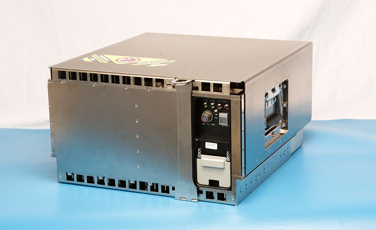
Harris Corporation delivered the first of 34 modernized receivers to support the GPS Next-Generation Operational Control System (OCX). They will receive the signals sent by the current GPS satellite constellation plus the new signals sent by the next generation GPS III — 13 military and civilian signals in all.
The receiver was shipped to the prime contractor, Raytheon Company, in Aurora, Colorado, after it passed a critical electromagnetic interference test, the first of many stringent qualification requirements. Though the receivers will be placed throughout the world, this first production unit will be installed in Aurora as OCX software development and integration continues.
OCX will replace the existing ground control system that receives signals from the 31 operational GPS satellites already orbiting Earth. Only OCX will be able to receive and decrypt all GPS III military and civil signals, however.
In addition to receivers, Harris has delivered 14 ground encryptors that will help protect the GPS signal. Harris also is providing critical software elements, which provide the fundamental navigation data to the GPS satellites and enable U.S. Air Force operators to better know and monitor the exact position and timing of the GPS constellation.
Risk Reduction Testing Completed for GPS OCX
Image: Raytheon
Raytheon reached a milestone in development of the GPS Next Generation Operational Control System (OCX), completing a series of Risk Reduction functional checkouts of OCX Block 1 capabilities, with a focus on OCX software.
This activity integrated iteration 1.5 of the OCX Block 1 Master Control Station with the GPS System Simulator and ran operational scenarios, representing the first end-to-end integration of available Block 1 capabilities.
The testing included GPS constellation management and sustainment, demonstrating OCX’s abilities for precision navigation and timing capabilities in a fully cyber-hardened environment.
The test also included running Kalman filters and generating GPS satellite navigation uploads. Future development will add to and expand capability to include both the civil and military modernized signals.
OCX’s development is delivered in “blocks,” with Block 0 comprising the Launch and Checkout System to take GPS III satellites into early orbit. Block 1 is built on Block 0 and delivers the full OCX capability, which allows the Air Force to transition from its current GPS ground controls to the modernized and secure GPS OCX master control station.
GPS OCX is being developed by Raytheon under contract to the U.S. Air Force Space and Missile Systems Center.
M-Code User Equipment Certified
L-3 Communications announced that its next-generation military code (M-code) GPS user equipment has successfully completed the final step in a government security certification process. L-3’s M-code GPS features advanced user equipment technology, increasing soldiers’ ability to resist enemy jamming and spoofing and performing significantly better in contested environments. The development and certification of this technology was performed under the Air Force Military GPS User Equipment (MGUE) program led by the GPS Directorate.
Certification review was performed by an independent government review team, with a focus on the security design of the L-3 GPS User Equipment. The goal of these new security standards is to further protect the integrity of the navigation and timing solutions and provide required safeguards for critical information inside GPS User Equipment.
Work on this project will be done by L-3 Interstate Electronics Corporation (L-3 IEC), which is part of the Precision Engagement and Training sector within L-3’s Electronic Systems business segment.
The first eight GPS III satellites are under contract and in production at Lockheed Martin’s GPS III Processing Facility outside of Denver.
GPS III Satellites 9 and 10 Procured, Launches Targeted for 2022
The U.S. Air Force Space and Missile Systems Center awarded a contract option to Lockheed Martin Space Systems Company to procure two additional GPS III satellites, space vehicles nine and 10 of the next generation. The contract option procures long lead and production hardware.
“The GPS III SV 9 and 10 satellites are expected to be ready for launch in 2022, thus sustaining the GPS constellation and the global utility the world has come to expect,” said Lt. Gen. Samuel Greaves, the Space and Missile Systems Center’s commander.
The Lockheed Martin team is finishing up final testing and integration activities on the first GPS III satellite, GPS III SV01, and is preparing to deliver it to the Air Force later this year. The second satellite, GPS III SV02, is poised to have its major functional systems fully integrated into one space vehicle prior to starting its own environmental testing. GPS III SV03 also is beginning to take form in the company’s production clean room as its major subcomponents are being assembled. All eight of the first set of GPS III satellites are in various stages of production at Lockheed Martin’s GPS III Processing Facility outside of Denver.
The government expects to compete future purchases of GPS III satellites, beginning with GPS III SV 11. This competition will maintain the current technical baseline of GPS III and will add additional hosted payloads to increase system accuracy, search-and-rescue capability, and universal S-band compatibility.
European GNSS Service Centre Opens
The European GNSS Agency (GSA) is gearing up to assume its operational role for Galileo in early 2017. This summer, the GSA formally accepted the Loyola de Palacio facility in Madrid, Spain, that houses the European GNSS Service Centre (GSC). This is a significant milestone in the development of the programme and its service provision as Galileo’s “door to the GNSS world.”
GSA already oversees the operation and service provision for the European Geostationary Navigation Overlay Service (EGNOS), along with managing the security accreditation and general security provision for both programmes.
The GSC offers 1,100 square metres of space and employs over 40 people. Since 2013, the core team at GSC has been providing limited services and working as a precursor to GSC v1. Its key work includes supporting the lead up to Galileo Initial Services provision, along with operating the GSC Helpdesk, disseminating orbital products to the search-and-rescue community, supporting GNSS-related research and industrial activity, and monitoring user satisfaction.
Once operational, GSC v1 will be connected to the Galileo core system, enabling the long-anticipated Commercial Service. This service is expected to enter operations by mid-2017.
All four Galileo satellites are mated to the dispenser in readiness for the upcoming launch.
The launch campaign for the Nov. 17 Galileo launch from the French Guiana spaceport has entered its latest phase of preparations, with the mission’s four satellite passengers being installed on their multi-payload dispenser system.
The activity — performed in the Spaceport’s S3B clean room — clears the way for the satellites’ integration as a single unit atop the heavy-lift Ariane 5, which was transferred earlier this week from the Launcher Integration Building to the Final Assembly Building, where payload integration is set to occur, according to launch contractor Arianespace.
Designated Flight VA233, the upcoming mission is scheduled for a Nov.17 liftoff from the Spaceport in French Guiana at precisely 10:06:48 a.m. local time, with the four Galileo satellites subsequently being deployed into circular orbit during a mission lasting just under four hours.
Flight VA233 will mark Arianespace’s first use of Ariane 5 to loft spacecraft for Europe’s Galileo global navigation system, following seven previous missions with the medium-lift Soyuz — which carried a pair of satellites on each liftoff. Flight VA233 is scheduled as the company’s ninth launch overall performed so far in 2016, as well as the sixth this year using the heavy-lift workhorse. Arianespace’s full launcher family is rounded out by the light-lift Vega.
Two of the four Galileo satellites after their installation on the multi-passenger dispenser system, with a third positioned for its integration. (Photo: Arianespace)
Galileo is an important infrastructure program for Europe, creating a civil global satellite navigation system that provides highly accurate positioning with great precision and reliability.
It is funded and owned by the European Union, with overall responsibility for management and implementation held by the European Commission. Design and development of the new generation of systems and infrastructure has been assigned to the European Space Agency.
OHB System in Bremen, Germany, built the Galileo satellites, which are sized at 2.7 x 1.2 x 1.1 meters, while their navigation payloads were supplied by UK-based Surrey Satellite Technology.
By Karen Parrish, DoD News, Defense Media Activity
An Air Force program that will provide a vital new command system for the global positioning system satellite constellation in the shortest time possible will continue despite cost growth, Defense Department officials have confirmed.
Frank Kendall, undersecretary of defense for acquisition, technology and logistics, announced Oct. 12 the continuation of an over-cost program supporting the global positioning system. Here, Kendall is briefed by Jose Romero-Mariona on cybersecurity science and technology during Kendall’s visit to Space and Naval Warfare Systems Center Pacific in San Diego, Aug. 24. (Navy photo by Aaron Lebsack)
The next-generation operational control system, known as OCX, reached what is called a Nunn-McCurdy breach on June 30. The Nunn-McCurdy provision applies to weapons programs and requires the military services to notify Congress if a program’s cost per unit increases 25 percent or more over the current baseline estimate.
But well before June 30, defense acquisition experts began working with Raytheon, the contractor for OCX, to resolve program issues. In December 2015, Undersecretary of Defense for Acquisition, Technology and Logistics Frank Kendall directed in-depth quarterly reviews, including a series of “deep dives” overseen by him. Certification activities began in July 2016, and culminated with Kendall certifying the program to Congress yesterday, thus allowing the program to continue.
Next-Generation GPS
James MacStravic, acting assistant secretary of defense for acquisition, discussed OCX and its importance with DoD News.
“This is what the controllers on the ground are going to use to make sure that all the satellites are talking to each other, that they’re exchanging the same information [and] that they’re where they’re supposed to be,” he said.
The OCX system will command all modernized and legacy GPS satellites, manage all civil and military navigation signals and provide improved cybersecurity and resilience for the next generation of GPS operations.
The OCX program includes the following phases: Block 0, to perform launch and checkout of GPS-III satellites; Block 1, to command all navigation signals, including the modernized military signal; and Block 2, for additional enhancements to signal assurance and navigation warfare capabilities. The ground segment capability not only supports military forces, but also civil, commercial and scientific uses. The current total program cost estimate for OCX is $5.46 billion.
OCX will consist of:
A master control station and alternate master control station;
Dedicated monitor stations;
Ground antennas;
GPS system simulator; and
Standardized space trainer
Turning the Program Around
Defense officials said factors in the OCX cost growth included late recognition of the magnitude of information assurance work that was required, concurrent systems engineering that drove significant rework, inconsistent configuration management of the program baselines, immature software and a lack of automation across the program. These issues drove schedule slips, which in turn increased the cost of the program, leading to the breach.
MacStravic described the efforts defense officials and Raytheon have made to turn the program around. He emphasized the work has included the personal involvement of Kendall, Air Force Secretary Deborah Lee James and Raytheon’s chief executive officer.
“What we spent the summer doing was making sure … does this program have the right management resources, the right financial resources and an appropriate schedule to succeed?” MacStravic said.
Officials report that after three on-site quarterly reviews, Kendall’s assessment is that Raytheon is making substantial progress on the program, but that some additional schedule increase has occurred and that there is risk of more schedule increases.
Progress has been sufficient to support certification under the Nunn-McCurdy process, officials said. Kendall’s office will continue the OCX quarterly reviews begun in March 2016, which to date have included the secretary and principal deputy acquisition chief of the Air Force, the program executive officer and Raytheon’s chief executive officer.
The alternatives to certifying the program included several options, including program termination, but this was deemed simply unworkable, due to the extended time it would require to design and field a new ground system for the vital GPS III network.
According to officials, the future of the OCX program will depend upon Raytheon’s ability to demonstrate that it can deliver the needed capability to the Air Force at acceptable cost and within an acceptable time.
Eos Systems Inc. has introduced new photogrammetry software optimized specifically for photographs taken with drones or unmanned aerial systems (UAS).
The new PhotoModeler UAS 2016 creates 3D models, measurements, and maps from photographs taken with ordinary cameras built-in or mounted on drones. It has numerous features for operation with drone photos, including post processing kinematics (PPK), volume objects, full geographic coordinate systems support, multispectral image support and control point assist.
Eos Systems will be showcasing PhotoModeler UAS Oct. 31 to Nov. 2 at the Commercial UAV Expo in Las Vegas, and will offer the new software at 35 percent off the normal price Nov. 1-30.
The new version of PhotoModeler is suited for drone photogrammetry applications, including surveying, ground contouring, surface model creation, stockpile volume measurement, mining and mine reclamation, environmental analysis, slope analysis, forensic analysis, construction and agricultural crop analysis.
New applications for drone photogrammetry are developed monthly. Eos PhotoModeler was introduced 23 years ago and has become one of the leading photogrammetric software platforms with a wide range of users in fields such as architecture, engineering, surveying, research, manufacturing and forensics.
PhotoModeler UAS 2016 software includes numerous features that provide higher performance in drone photogrammetry. Camera calibration is optimized for high accuracy with UASs and GPS. Post processed kinematics (PPK) makes it possible to correct a survey with GPS data after the fact for survey grade accuracy.
Volume objects provide easy and accurate volume data for stock piles and mining operations. Full geographic coordinate system support enables users to work in their local geographic coordinate system for better compatibility. Support is provided for multispectral images including Normalized Difference Vegetation Index (NDVI) surface models and orthomosaics for precision agriculture. An intuitive interface is provided for efficiently marking ground control points.
Two workshops convened in recent weeks in the U.S. and Canadian capitals, respectively, sought to bring into focus looming threats to the nations’ positioning, navigation and timing capabilities and critical infrastructures. Some of the threats are pervasive — jamming and spoofing — and formed the general topic of the Canadian workshop. Some threats are specific — powerful terrestrial transmitters overwhelming GPS/GNSS receivers — and occasioned the U.S. gathering.
Canada. In a first for Canada, the October 21 GNSS Vulnerabilities Innovation Policy (VIP) Workshop brought together 19 federal government departments as well as provincial and municipal agencies and private sector companies. U.S. State Dept. and Homeland Security gave presentations, as did the European Space Agency, Bell Canada, NovAtel and Spirent Communications.
Integrity challenge for automotive positioning, presented by NovAtel
The workshop was sponsored by the the Federal Global Navigation Satellite Systems Coordination Board (FGCB), a government board with representations from various government departments and agencies. The GNSS Coordination Office (which organized the workshop) is hosted at Canada’s Ministry of Innovation, Science and Economic Development and sponsored by the FGCB members.
Presentations covered such topics as Demonstration of the Geolocation of GPS Jammers, GNSS & the Telecom Sector, Detecting and Protecting Against GPS Cyberthreats, and Safety Critical, High Precision, GNSS Positioning for Autonomous Vehicles.
United States. The U.S. Department of Transportation (DOT) hosted its fifth workshop on the GPS Adjacent-Band Compatibility Assessment effort on October 14. This lengthy, thorny and occasionally acrimonious process started out benignly enough in 2010 with the statement, “Demand for commercial spectrum to support broadband wireless communications has led the government to consider repurposing various radio frequencies, including the satellite communications bands next to GPS.”
The workshop discussed the results from testing of various categories of GPS/GNSS receivers including aviation (non-certified), cellular, general location/navigation, high precision and networks, timing, and space-based receivers. The workshop also included a discussion on the development of use-case scenarios for these categories — which is where the going got heavy and differences of opinion truly emerged.
The furor stems from a renewed effort by Ligado, formerly known as LightSquared and now re-emergent from a 2-year bankruptcy process, to convert relatively inexpensive satellite-to-earth spectrum into very valuable terrestrial spectrum. The company stands to gain billions of dollars and secured rights from the process.
Members of the DoT team presented the first results from the GPS Adjacent-Band Compatibility (ABC) Assessment, an effort to determine the power limits by frequency, or interference tolerance masks (ITM), needed to protect both existing and future GPS receivers. Test results indicated a need to limit interfering signals at different levels depending on the type of receiver being used. 80 receivers in six categories were tested: cellular, general location/navigation, general aviation, timing, high precision and space receivers. Certified and military receivers are undergoing separate tests.
The tests of current receivers took place April 25–29 at White Sands Missile Range, New Mexico, using a 100 x 70 x 40 anechoic chamber. The signals used in the test included GPS L1 C/A-code, GPS L1 P-code, GPS L1C, GPS L1 M-code, GPS L2 P-code, SBAS L1, GLONASS L1 C, GLONASS L1 P, BeiDou B1I and Galileo E1 B/C. Tests were conducted within 100 megahertz on either side of the GPS L1 center frequency of 1575.42 using a 10-megahertz LTE signal and a narrow bandwidth 1-megahertz bandpass white noise signal.
The tests were conducted for GPS and GNSS receivers processing signals in the 1559–1610 MHz Radionavigation Satellite Service (RNSS) frequency band, as well as receivers that process Mobile Satellite Service (MSS) signals in the 1525–1559 MHz band to receive differential GNSS corrections.
The tests determined the power levels at which each device experienced a one-decibel degradation in the carrier-to-noise density ratio (CNR) at a particular frequency. The DoT team graphed results for each device. The recommended power limits were the lowest in frequencies closest to the GPS bands.
The receivers most affected by the test transmissions were identified as high-precision receivers. They experienced interference at power levels as low as –90 to –95dBm at around 1550 MHz and –90 dBm at roughly 1610 MHz.
The strictest limit for both the general aviation, general navigation/location, and timing receivers was a little below –80 dBm at about 1550 MHz, while space-based receivers were equally sensitive on both sides of the RNSS band with the toughest limit being about –85 dBm.
FAA. The Federal Aviation Administration (FAA) has authority to set power and out-of-band emissions limits to meet aviation safety standards, and it had been thought that these limits might address interference with other types of receivers as well. But the test results showed that “protecting the FAA-certified mask does not necessarily protect the rest of the receiver categories,” according to Hadi Wassaf, technical lead for GPS interference analysis at DoT’s Volpe Center.
Use Cases. Ligado has proposed that position error as experienced by the user is a better guide to interference levels than degradation in the carrier-to-noise density ratio. The GPS community generally opposes this approach. The next step is the development of use cases. According to the test plan, use cases define the regions of operations for a receiver, and they identify applications that “that are vital to economic, public safety, scientific, and/or national security needs and any other factors supporting why this particular receiver model is important to be tested (e.g., quantity in use, economic impact, etc.).”
 Not with Purple Haze, but with signal interference — although, come to think of it, the two may be not unalike, phenomenologically.