Australia is moving north at the rate of approximately 2.75 inches per year, causing it to be out of sync with GNSS positioning by nearly five feet, reports the BBC. Scientists are working to correct the measurement problems this situation creates.
The shift, caused by normal tectonic movement, is causing a discrepancy that would interfere in the future use of self-driving cars. Another affected industry is precision agriculture, where self-driving tractors till fields.
The Australian government has launched a project to align with GNSS. To do this, the Geocentric Datum of Australia will need to be updated with correct coordinates — which hasn’t been done since 1994 — despite the fact that Australia rests on the fastest moving continental tectonic plate on Earth.
On Jan. 1, 2017, Australia’s local coordinates will be shifted north by 5.9 feet. The update to the local coordinate system will overshoot to account for more movement and predict where the continent will be in 2020.
Geographic information system (GIS) provider Esri has partnered with Swiss-based spatial measurement instrument manufacturer Leica Geosystems to encourage innovation of mobile field data collection in government by offering grants totaling $143,250 in goods and services.
Known as the Smart Communities Innovation Challenge, 10 governments that submit detailed project proposals demonstrating increased efficiencies in collecting data for decision support or improved productivity in delivering governmental services will be selected to receive a grant.
Project proposals will be accepted from Aug. 15, 2016, until the official submission deadline at 5 p.m. (Pacific daylight time) on Oct. 14, 2016. Grant recipients will be announced on Oct. 31.
To be entered for consideration, proposal submissions must be uploaded in conjunction with the organization’s identifying information through a form on the Smart Communities Innovation Challenge landing page.
So long as operations are based in the United States, any government or department, whether municipal, regional, special districts, state, city, county, or otherwise, is qualified to receive a grant.
To be selected, it is necessary that a project confirm the value of combining GIS and Global Positioning System (GPS) technologies for data collection, optimizing workloads, and providing real-time information that supports field mobility. Proposal reviewers will look for ideas that support complete workflows extended to back-office processes such as operational dashboards.
Priority will be given to projects that tie GIS and GPS to daily workloads, influence sharing of geographically enabled data across multiple jurisdictions or interdepartmental ventures, and clearly convey a perceived benefit or return on investment.
The intent of the joint program is to supply governments with the tools to succeed as they implement progressive methods to streamline workflows. By providing technology, training, and technical support grants, Esri and Leica aim to inspire legislative bodies to devise transformational approaches to improving the efficiency of mobile fieldworkers.
As innovative ideas from the government community are brought forward for solving real-world problems, the best applications will be those of universal appeal and the ability to be shared between governments through an open exchange hub.
The challenge’s grant winners will be thought-leading governments that have plans in place to jump-start projects such as facility inspections, emergency reporting, asset inventory, environmental management and monitoring, efficient employee routing, code enforcement, population and housing enumeration, mosquito abatement and/or sign inventory.
To learn more about the Smart Communities Innovation Challenge and other grants sponsored by Esri, visit go.esri.com/pr-mobilegrant.
Trimble has acquired Axio-Net GmbH from Airbus Defence and Space. Based in Hannover, Germany, Axio-Net is a provider of GNSS corrections and professional data services serving Germany, the United Kingdom and Benelux. Financial terms of the transaction were not disclosed.
Axio-Net, founded in 2008, delivers both real-time and post-processed network real-time kinematic (RTK) solutions to a broad range of users including surveyors, GIS professionals and farmers. In addition to traditional correction services, Axio-Net performs a variety of data-based professional services for the geospatial market, including coordinate transformation services as well as network set-up, configuration and operations consulting.
“Our philosophies are highly complementary and together, we will extend Trimble’s position as a global leader of GNSS corrections,” said Patricia Boothe, general manager of Trimble’s Advanced Positioning Division. “We are committed to supporting Axio-Net’s brand-agnostic position, while we leverage their experience with professional services, not only in traditional markets such as geospatial and agriculture, but in emerging high-accuracy GNSS markets such as automotive.”
Three recent publications offer a range of perspectives on GNSS technology, the accompanying industry and its effects on the world we live in. They are rather like surveying the topic through three types of looking glass: a mirror, a microscope and a telescope. I recommend them all.
From the first listed below (Misra), you may not learn much new about GPS or GNSS, but you’ll experience something like looking at your reflection or reading an encyclopedia entry about yourself. You’ll get a view of of the GPS ecology in this case, as a broad and curious public might. And that is in itself a learning experience. “O wad some Power the giftie gie us / To see oursels as ithers see us!” — Robert Burns. Read it yourself before giving it to someone you know, of almost any age but probably high school or older, who is curious but not necessarily scientific.
The second book, by Greg Milner, examines the technology and its impact much more closely and at much greater length. With a few dashes of history and generous helpings of current events, it makes the point that GPS is not only changing our lives, but our minds. That can be a scary thought. The book lays out a very rich and fascinating tapestry of interwoven trends, personalities, anecdotes and conjectures. Again, read it yourself before giving it to anyone who …
The third publication cited here, a white paper by Rolls Royce and colleague companies, is an online resource showing just where the world is headed. It treats only one realm, marine shipping, but it lays out a convincing vision of a future shaped and directed by PNT that can easily be overlaid onto many other forms of transportation and commerce. U.S. Transportation Secretary Anthony Foxx said it recently: autonomous vehicles are coming, whether the world is “ready or not.”
GPS for Everyone: You Are Here
by Pratap Misra
Ganga-Jamuna Press (available on Amazon)
By the co-author of one of the core technical references on GPS and a graduate-level engineering text (Global Positioning System: Signals, Measurements, and Performance, ), this large-format, large-print volume takes a beginner’s view. Although Misra says at two junctures, “we learned to solve [such] equations in high school algebra” and “you may remember from calculus,” no math is necessary to take in the overall view and basic facts of satellite navigation concepts. As the author states, the only prerequisite for this book is curiosity.
With chapters on Nuts and Bolts, Signals, Math, Relativity, a Tool of Science, Smart Bombs and more, this primer gives a comprehensive overview of just about everything the general user could well afford to know about GPS. The one shortcoming from a public information point of view is that many of the wide-ranging applications and market sectors are given short shrift. The importance of precise timing and GPS’ role in critical infrastructure get two paragraphs. A somewhat pejorative chapter on other GNSS labels them all “wannabes” and makes the surprising assertion that “when Putin goes, so could GLONASS.”
Pinpoint: How GPS Is Changing Technology, Culture, and Our Minds
by Greg Milner
W.W. Norton & Co.
GPS marks yet another rite of passage with the publication of Pinpoint: a full-length journalistic investigation of its development, personalities, and societal impact, with a diverting assortment of side stories and philosophical illuminations. A technology can be said to have arrived when it receives this manner of broad-market, though rigorous, intelligent, probing treatment. Never mind that every such technology truly arrived long before their books were written.
This is not a book to give to friends and relations who ask you “How the heck does GPS work?” (For that, see Pratap Misra’s book.) It does spend a bit of time on that subject, a very little bit. Neither is it a history of GPS. Author Greg Milner spends a bit more time on that topic, and his direct sources are impeccable. The major portion of the book is devoted to “contemporary history,” if there is such a thing: the sprawling tentacle-like growth of GPS into many industries and aspects of modern life.
Milner does not chronicle every one or even a plurality of these diverse fields. One gets the feeling he pretty much followed his journalistic nose into whatever interested him. Sections explore early receiver development, electrical power, financial markets, tracking (both personal and fleet), agriculture with a focus on the sugar beet, auto navigation, and a few more. Throughout, Milner pushes forward anecdotes — personal recollection of many, many diverse contributors and benefitees, or in a few cases, victims. One chapter bears the title “Death by GPS.”
He takes long, looping sidetrips that are always interesting, far though they may wander. The most notable case is that of Polynesian cross-Pacific navigation, a mental construct called etak, which takes up, at length, the first chapter of the book. We become aware that possibly what interests Milner most is navigation as a state of mind. He attempts to tie it all together at the end; it doesn’t quite work, but the many questions he raises along the way are certainly worth pondering.
Two examples, only pages apart. In an investigation of the legality and Constitutional issues of tracking and surveillance by law enforcement, he states: “GPS provides the possibility of omniscience, unlike any previous technology. There is nothing ‘natural’ about using GPS to keep a continuous inventory of the world’s moving parts. It reflects a choice, a conscious application of a neutral technology . . . GPS itself is a blank slate onto which we project our desires.”
And in a section on marketing: “Stickiness, a term online marketers apply to websites that encourage repeat visits, could also describe how GPS lets us ‘build situational contexts around things and people to create new meanings, associations and stickiness of disparate data. The simplest example is when we use a program like Google Maps to learn about our location, a sticky query that draws in satellite mapping, ground-level photography, and business information.”
Remote and Autonomous Ships: The Next Steps Available online from Rolls Royce and the AAWA
The Advanced Autonomous Waterborne Applications Initiative (AAWA) published a white paper in June as part of presentations at the Autonomous Ship Technology Symposium 2016 in Amsterdam. The white paper outlines the Project’s vision of how remote and autonomous shipping will become a reality.
Oskar Levander, Rolls-Royce Vice President of Innovation – Marine, said “This is happening. It’s not if, it’s when. The technologies needed to make remote and autonomous ships a reality exist. The AAWA project is testing sensor arrays in a range of operating and climatic conditions in Finland and has created a simulated autonomous ship control system which allows the behaviour of the complete communication system to be explored. We will see a remote controlled ship in commercial use by the end of the decade.”
The AAWA white paper explores the research carried out to date on the business case for autonomous applications, the safety and security implications of designing and operating remotely operated ships, the legal and regulatory dimensions and the existence and readiness of a supplier network to deliver commercially applicable products in the short to medium term.
Positioning Technologies. The proposed system draws on a range of sensors (see Figure 1) including GPS, inertial, lidar, cameras, short-range radars, and electronic charts. “When combined witha global or local positioning reference such as GNSS, and with wind sensors and inertial measurement units, the ship is able to keep its position even in rough weather conditions,” states the report. “The main question is therefore not whether the implementation of autonomous ship navigation is technically possible, but what is the combination of technologies and methods that provides the level of performance and reliability that is required for practical operation of large vessels, and at a reasonable cost.”
The white paper draws on a wide range of expertise from academic researchers at some of Finland’s leading universities. Industry input has been provided by leading members of the maritime cluster including Rolls-Royce, Brighthouse NAPA, Deltamarin, DNV GL and Inmarsat.
The project also has the support of shipowners and operators. The tests of sensor arrays are being carried out aboard Finferries 65-metre double ended ferry, the Stella, which operates between Korpo and Houtskär. ESL Shipping Ltd is helping explore the implications of remote and autonomous ships for the short sea cargo sector.
Jackson Labs Technologies Inc., a designer and manufacturer of GNSS, timing and frequency equipment, is releasing several new products with full support for the new and emerging Galileo satellite navigation system, as well as a free software retrofit to existing products that adds Galileo functionality.
Jackson Labs’ low-phase-noise Rubidium GNSS disciplined oscillators (GNSDO).
The European Galileo satellite navigation system has now become a reality with recent launches and commissioning of Galileo satellites. Three to four Galileo satellites can now typically be tracked on average in the continental U.S., and additional space vehicle launches are planned for later this year and next year that will significantly improve Galileo availability.
Jackson Labs has upgraded its Mini-JLT GPSDO with an eighth-generation GNSS NEO-M8T timing receiver from u-blox that allows receiving Galileo signals as well as concurrent GPS, GLONASS, BeiDou and QZSS signals.
Users can choose to operate a single GNSS system, or multiple concurrent GNSS systems for redundancy. Concurrent operation aids performance by allowing reception of up to 72 GNSS satellites in challenged reception areas such as in urban canyons, under foliage, indoors, or close to the Earth’s poles.
“A new era of global navigation system performance has arrived with the advent of enough usable Galileo space vehicles that are now allowing first positioning and timing operations,” said Jackson Labs President Said Jackson. “Galileo promises new technology and performance levels over the many decades-old GPS and GLONASS systems, and we are excited to lead the way with our new Galileo product line.”
The Galileo GNSS promises significant improvements in timing and frequency performance due to improved on-board hydrogen maser atomic references (Cesium and Rubidium references are used in GPS and GLONASS satellites) and other system improvements.
In stationary timing mode, the new Galileo-capable GNSS disciplined oscillator (GNSDO) products will operate with as little as one single satellite in-view, and can use additional satellites to improve timing stability and accuracy via an over-determined timing solution for oscillator disciplining. Indoor tracking is possible with a GNSS performance of down to -167 dBm.
These new Galileo GNSDO’s provide 1 PPS timing, position and navigation (PNT) data, as well as highly stable and accurate 10-MHz reference outputs. The M12M replacement receiver also provides a user-adjustable timing/frequency output with 1 Hz to > 10 MHz adjustment range, while the low-noise rubidium GNSDO can provide a typical holdover performance of up to, and better than 500 nanoseconds over 24 hours.
Besides introducing the new Mini-JLT GNSS module, JLT also makes available concurrent Galileo reception via a free software update to existing customers of the JLT M12M replacement receiver, and the low-noise Rubidium product line.
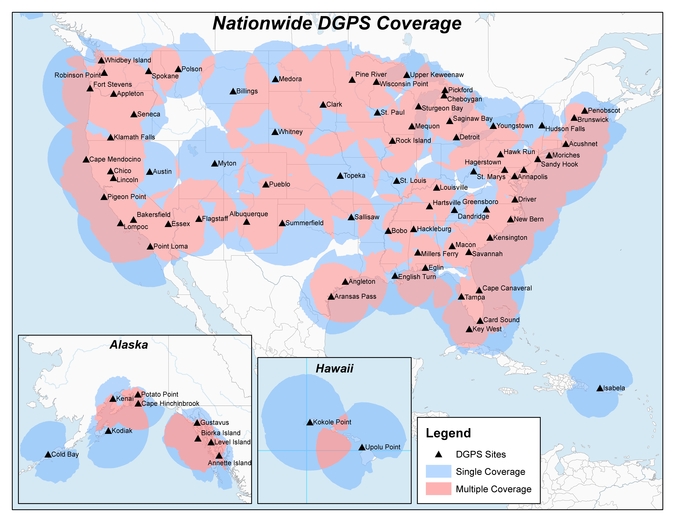
Heartland Corrections Services Now Commercial or WAAS-only
Original NDGPS coverage.
The U.S. Coast Guard, Department of Transportation and Army Corps of Engineers have reduced the number of Nationwide Differential Global Positioning System (NDGPS) sites that will be decommissioned. The course correction keeps a coastal and Mississippi River network of stations largely intact, while discontinuing inland services.
Last year at this time, the agencies sought public comment on a proposed shutdown of 62 of 84 NDGPS sites.
“After a review of the comments received, we have reduced to 37 the number of NDGPS sites to be shut down, nine of which are USCG Maritime sites and 28 of which are DOT inland sites,” the notice reads. “The NDGPS system will remain operational with a total of 46 USCG and USACE sites available to users in the maritime and coastal regions.”
Graphic depicting NDGPS coverage after site reductions. (U.S. Coast Guard)
Public use of NDGPS, never robust, has declined in large part due to limited availability of DGPS receivers. Many users and applications, particularly in precision agriculture, have shifted to commercially provided services or Wide Area Augmentation System (WAAS) corrections instead.
NDGPS coverage is maintained in major maritime ports and waterways. See www.federalregister.gov for a list of sites to be decommissioned. Termination of the broadcast signal is scheduled to occur by Aug. 5.
OCX Deep Dive Finds Progress, Need for Funds
The Pentagon seeks $39.2 million from Congress to speed the next-generation GPS ground control system (OCX) towards completion. Without the infusion, OCX would be delayed an additional four months and cost $90 million more to complete, the Pentagon said.
The embattled OCX showed progress in its July 7 quarterly review, according to an Air Force statement. DOD officials and Lt. Gen. Samuel Greaves, Space and Missile Systems Center commander, concluded Raytheon has made progress implementing critical changes.
On June 30, OCX exceeded baseline cost estimates by at least 25 percent, triggering a Nunn-McCurdy breach and potentially halting all work. Further OCX review will wind up in October. The Pentagon announced in 2015 that it was delaying initial OCX operations for the ground system until July 2021.
GPS III satellites. which may first launch in 2017, cannot use their full capabilities with the current ground control system, but the Air Force plans to use a retrofit to work with the GPS III designs until OCX is operational. See gpsworld.com/updatesyndrome for more details.
Galileo and the Brexit Effect
Tension Grows over the Public Regulated Service
By Tim Reynolds, European editor
UK involvement in the European Space Agency (ESA) should be unaffected by Brexit — the UK leavetaking, as yet undetermined in its details, from the European Union. ESA is a separate institution from the EU. However, one could argue that non-EU-membership might diminish the UK voice and could require a higher financial contribution.
Bids for the next Galileo satellite purchase contracts were due in mid-July, and the European Commission indicated that it will consider them purely on commercial terms. Airbus Defence and Space and Thales Alenia Space were expected to bid, as was the incumbent supplier of the first 22 satellites, OHB SE of Bremen, Germany, with Surrey Satellite Technology Ltd. (SSTL) of Britain as OHB’s satellite payload developer.
The EU has historically been averse to non-EU companies taking major roles in Galileo, and the immediate question is whether the EC could accept an SSTL-built payload that would not be launched until after Britain’s exit is complete.
Paul Verhoef, ESA’s director of navigation, said he will manage the competition as if Brexit had not occurred, with no discrimination against British bidders. Marco R. Fuchs, chief executive of OHB, said OHB would continue the front-line role for SSTL.
Britain could negotiate a security similar treaty similar to one reached by Norway and the EU, that could become effective on the date of Britain’s departure.
If I were a betting man, I’d still wager the house on the incumbent consortium winning the contract to provide the remaining satellites required to provide a sustainable, 24/7 operational constellation for first-generation Galileo. There would, in my opinion, be an unwarranted technical risk in doing anything else.
However, for the next generation it is open season, of course.
PRS at Risk. The real worry must be for the Public Regulated Service (PRS). This is the unique feature of Galileo that is of great interest to civil and military authorities in Europe and beyond, due to its more robust encrypted signal and its potential anti-jamming and spoofing characteristics. Currently, PRS will only be available to EU Member States. However, other countries, including the U.S. and Norway, have indicated that they would love to be able to use it as well. No final decision on this has yet been made.
The loss of the automatic right to access PRS would be damaging to the UK, and potentially to the full Galileo deployment timetable, as the country is currently host to the back-up Galileo Security Monitoring Centre (GSMC) — an essential part of PRS infrastructure — and I cannot see any part of the PRS infrastructure being left in a non-member state. If the centre must be relocated, then deployment of the full service could be delayed.
In addition, UK involvement in research and innovation activities around PRS may be curtailed, even if other work on Galileo projects is not.
UK a PRS Leader. The UK has been a leader in developing PRS applications. Nottingham Scientific Limited (NSL) recently demonstrated cloud-based PRS applications including implementation of PRS authentication for an offender tag, done using live Galileo (and GPS) signals. The demonstration provided real-time authentication flag generation, release and delivery to users. A second demo used cloud-based PRS in a proof-of-concept remote, unattended timing station where the primary user requirement was 100-percent confidence for the validity of signal. A third demonstration illustrated the use of cloud-based PRS on a drone.
Dual-Use Debate
PRS was also a major talking point at the European Space Solution event in The Hague in May. A panel on Space and Security noted that despite the fact that Galileo is marketed as a civil controlled GNSS, “dual use” is becoming a potentially divisive area for debate.
Rini Goos from the European Defence Agency (EDA) said that the EU needed space systems to be able to “intervene successfully,” and that space strategy needed to support Member State defence capabilities. This meant that the next generation of EU space systems must have dual-use capability. NATO is entrusted with external defence of the EU, but the commission also needs to be able to provide defence, not just consume it, he concluded.
The current chairman of the Galileo Security Accreditation Board is a UK citizen, Jeremy Blyth. He said: “Space and security, security and space. Whichever way we say it, what is clear is that the two are inextricably linked together.” He believes that to ensure security, it must be “designed in from the beginning.” Security is an enabler, rather than a barrier, he claimed.
He also believes that PRS gives the EU a real and competitive edge in secure positioning.
However, he indicated that there is a need to think deeply and have a rational debate about dual-use systems and, in particular, about the interface between civil and military use.
Clearly, there is a growing tension with regard to overtly military use of Galileo both now and in future generations of the system. Although a largely philosophical debate, given who in reality will be controlling and using PRS within many Member States, many European and national policy makers will want to retain the “purity” of Galileo as a global positioning system under fully civilian control.
PRS Workshop
Security was also a key feature of the PRS workshop organised by the Netherlands EU Presidency toward the end of European Space Solutions. Ger Nieuwpoort, director of the Netherlands Space Office (NSO), reminded the audience that “For civil authorities, PRS provides the same level of security for Member States as the military in GPS.”
Bart Banning of the Netherlands Institute of Navigation asked “How will we use PRS?’” In terms of its use for protecting critical infrastructure, what if the owner of the infrastructure was a private company? Should it be granted access to PRS or have to make do with the Galileo Commercial Service, a.k.a. PRS-lite?
He also pointed out that PRS was no more protected against jamming than any other GNSS. And, currently, it was “not good for in-building, underground or underwater.”
He thought PRS could be a great time provider, but probably also needs ground transmission, possibly via legacy radio towers. However, he saw the “killer app” for PRS being asset tracking, such as for diamonds, VIPs or prisoners. He also agreed that for many EU countries, the ministry of defence will be overseeing PRS services. “PRS is a good and unique addition to GNSS — but not the answer to all our needs.”
Interest in the Iridium constellation as a potential alternative and back-up provider of positioning and timing has increased with the announcement of impending operational capability. Overall concept information is hard to come by, but this 2009 ION GNSS paper gives an early look. The text is from the paper’s abstract.
The iGPS high-integrity precision navigation system combines carrier phase ranging measurements from GPS and low Earth orbit Iridium telecommunication satellites. Large geometry variations generated by fast-moving Iridium spacecraft enable the rapid floating estimation of cycle ambiguities. Augmentation of GPS with Iridium satellites also guarantees signal redundancy, which enables fault-detection using carrier phase Receiver Autonomous Integrity Monitoring (RAIM). Over short time periods, the temporal correlation of measurement error sources can be exploited to establish reliable error models, hence relaxing requirements on differential corrections. In this paper, a new ionospheric error model is derived to account for Iridium satellite signals crossing large sections of the sky within short periods of time. Then, a fixed-interval positioning and cycle ambiguity estimation algorithm is introduced to process Iridium and GPS code and carrier-phase observations. A residual-based carrier phase RAIM detection algorithm is described and evaluated against single-satellite step and ramp-type faults of all magnitudes and start times. Finally, a sensitivity analysis focused on ionosphere-related system design variables (ionospheric error model parameters, code-carrier divergence, single- and dual-frequency implementations) explores the potential of iGPS to fulfill some of the most stringent navigation integrity requirements with coverage at continental scales.
ComNav Technology has released its advanced K700 and K708 GNSS OEM boards to the international market.
K700 OEM Board
With the advanced ComNav application-specific integrated circuit (ASIC) chip, K7-series OEM boards have higher observation data quality and lower power consumption compared to previous K5-series OEM boards. The data output rate also increases substantially by working with a new Atmel processor.
As a cost-effective GNSS OEM board, K700 is scalable for sub-meter to centimeter-level positioning applications such as geographic information systems (GIS), precision agriculture, marine and automotive systems.
It can track GPS L1, BeiDou B1, GLONASS L1 and SBAS, and also supports PPS, Event Marker and short baseline RTK. The size, weight and power specifications of the K700 make it easy to be customized and integrated, the company said.
K708 OEM Board
For the K708 OEM board, the inside GNSS tracking engine with 388 channels is capable of tracking all current and future constellations. K708 is designed with strong compatibility and built-in functions, including high-accurate PVT output, long baseline RTK and reserved webserver service.
The 8-GB onboard memory provides sufficient storage space to record the raw data without an external memory card. Therefore, K708 OEM board is designed for CORS, deformation monitoring system and related high-accuracy GNSS positioning applications.
Imagine life without GPS. For those of us old enough, that might not be hard to do. For younger people, it’s almost unimaginable. Now imagine that GPS — for whatever reason — is suddenly unavailable. What if you’re not on land, where printed maps are filled with landmarks? What else do you rely on?
Before GPS, early explorers navigated by the stars using celestial navigation and a sextant, the same basic techniques that guided ancient Polynesians in the open Pacific and Magellan around the world (the first sextant device was invented in 1757 by John Bird).
As Don Jewell describes in his gripping Defense PNT newsletter column “Lost Over the Pacific,” a massive electrical failure on his aircraft caused the crew to rely on his skills navigating with a sextant. “The crew regarded me with some skepticism as they realized I intended to use an old-fashioned sextant to determine the speed and heading and then navigate a multi-hundred-million-dollar modern reconnaissance aircraft,” he recalls.
Despite its usefulness when things go sideways, celestial navigation was pulled from the curriculum at the U.S. Naval Academy in the late 1990s, considered “outdated.” The course time was replaced with GPS and electronic navigation. Among the fleet, the Navy ended training in celestial navigation in 2006. A similar course at the U.S. Coast Guard Academy ended 10 years ago, but some instruction remains in theories of celestial navigation, and cadets use a sextant aboard the tall ship Eagle.
Now, however, what’s old is new again. The Naval Academy has brought back celestial navigation courses, recognizing the importance of giving future naval officers the ability to find their position out at sea in case GPS is unavailable through jamming or hacking.
After all, an old-fashioned sextant can’t be hacked.
Broadcast Date: Thursday, October 25, 2012 Speaker: Eric Gakstatter, contributing editor for survey and GIS Summary: This month, a new GPS satellite was launched, India launched a new SBAS satellite, and two Galileo satellites are scheduled to launch. Last month, China launched two more BeiDou satellites. There’s a lot of activity of the satellite navigation industry. In the webinar, I will discuss what these new developments mean to the surveying/mapping user, as well as other current events.
Sponsored by: Hemisphere GNSS Broadcast Date: Thursday, May 16, 2013 Moderator:Alan Cameron, Editor & Publisher, GPS World Speakers: Mark Sampson, LabSat Product Manager, RaceLogic; John Fischer, Chief Technology Officer, Spectracom; Markus Lörner, Product Manager, Rohde & Schwarz; Steve Hickling, Lead Product Manager, Spirent Communications; Mark Wilson, Vice President of Sales, IfEN GmbH Summary: Simulation and testing experts offer key technical insights on the intricacies and importance of product and signal testing, whether by simulator, record-and-replay, or in the field, in the increasingly complex environment of multiple modernizing and expanding GNSS signals, from GPS III to BeiDou, with Galileo coming on strong and GLONASS a perennial standby.
Sponsored by:Navcom Broadcast Date: Thursday, May 8, 2014
Moderator: Art Kalinski, Editor, GeoIntelligence Insider Newsletter
Speakers: John Ciampa, CEO, Alta; Ted Ralston, Executive Program Manager, Soft Power Solutions; Paul Smith, General Manager, Cyclomedia; Dr. Peter VanAmburgh, Business Development, IIF Data Summary: A steep-curve learning session on the current explosion of capture systems, made possible with cheap, small GPS and inertial measurement units. New oblique capture systems, improvements in 3D model capture, very accurate ground capture (see the Februrary GeoIntelligence newsletter column on Cyclomedia), high-resolution drifting balloons (AltaDrifter.com), cheap silent aerostats, unmanned autonomous air vehicles (UAVs), disposable UAVs, a new manned parafoil all-terrain vehicle (ATV) — yes, flying ATVs! — and more. Look into the future of data capture, because it’s coming at you fast, right now! View Ted Ralston’s launch demo video from the webinar View Dr. Peter VanAmburgh’s “Stalker” video from the webinar


 Imagine life without GPS. For those of us old enough, that might not be hard to do. For younger people, it’s almost unimaginable. Now imagine that GPS — for whatever reason — is suddenly unavailable. What if you’re not on land, where printed maps are filled with landmarks? What else do you rely on?