Purchase Decisions in the Evolving Landscape of GPS, Multi-GNSS and Alternative PNT
Sponsored by: NavCom
Broadcast Date: Thursday, June 5, 2014
Moderator: Alan Cameron, Group Publisher, GPS World & Geospatial Solutions
Speakers: Steve Ault, Product Manager, NavCom Technology Inc.; John Pottle, Fellow, Institute of Engineering Technology and Royal Institute of Navigation; Philip Mattos, R&D scientist for several GNSS companies; Paul Benshoof, Global Business Development Manager, Locata Corporation
Summary: Last month’s two GLONASS stumbles prompted some industry leaders to resume their calls for multi-GNSS and for redundant PNT. But neither concept yet exists, truly and pervasively, that is to say effectively for all users. When will reliable, robust, consistent and continuous positioning, navigation, and timing become a reality? Should we rely on whatever technology we currently possess until the perfect system comes available, or should we continuously upgrade at each iterative step along the way?
Category: GNSS
-
How Much Farther to the Promised Land?
-
Say Goodbye Proprietary GPS Devices, Hello TerraGo Edge
Broadcast date: Thursday, May 28, 2015
Sponsor: TerraGo
Moderator: Alan Cameron, Editor-In-Chief and Publisher, GPS World
Speaker: Michael Gundling, Vice President of Product Management, TerraGo
Summary: Say goodbye to expensive, single-use GPS handheld devices. That’s not the way it works anymore. TerraGo Edge replaces single-use GPS handheld devices and enables mobile workers and field crews to easily collect field data, share that data with others in real-time using any iOS or Android device and sync that information with headquarters at a fraction of the cost. With TerraGo Edge, you can save a significant amount of money, increase the ROI on your current GIS investments and improve productivity. -

BeiDou industry on path similar to GPS
The seventh China Satellite Navigation Conference (CSNC) met in May in Changsha, capital of Hunan province in south-central China. Chairman Mao attended high school and teaching college here, and the city has many monuments and stories about his younger days.
This was the seventh different host city for CSNC, as the China Satellite Navigation Office (CSNO) spreads the prestigious conference among various provinces.
The 2016 conference was every bit as big as last year’s in terms of number of attendees, papers presented, exhibit hall space and booths (77 exhibitors). I co-chaired the joint CSNC-Institute of Navigation (ION) panel with Dr. Jun Su. The session was well attended by both local Chinese experts and international visitors.
The collaboration between these two large GNSS technical organizations is an excellent trend as both benefit from the cross-fertilization. This September, there will also be a joint CSNC-ION panel at ION GNSS+ in Portland.
Industry Boom. The domestic Chinese satellite navigation industry is thriving, based on the growing availability of Beidou signals combined with the baseline GPS constellation. Government projects for a wide range of applications provide ample markets for domestic suppliers to build a solid business.
In general, however, the high-volume cellular handset market is still the domain of the traditional global suppliers, not only because of their experience with high-volume applications, but also the trend toward handset vendors requiring a complete platform solution including modem.

CSNC shows that startup companies seven years ago have grown into large, vertically integrated higher end suppliers, opening the low-cost, general purpose market sector for new entrants. I noticed a corresponding cyclic trend in the domestic industry, which is similar to the way the GNSS business evolved in other regions. The initial entrants, who were small startups seven years ago, have become relatively large, vertically integrated companies supplying higher end, higher value systems. Most of these are in the agriculture, fleet tracking and survey industry, and many of them are now publicly traded companies. This has opened up the low-cost, more general-purpose portion of the market for new entrants.
Several of those new companies were founded by people who have left their initial startups on acquisition to start again. Although this industry is somewhat geographically isolated market-wise (they service mostly domestic customers), the parallels to way the GPS market developed 15 years ago in the United States are absolutely uncanny.
Perhaps in an industry based on cyclical orbits of satellites, it shouldn’t come as a big surprise that there is an overarching cyclical trend in the way markets develop around the world. I look forward to attending CSNC 2017 as it returns to Shanghai, site of the second CSNC in 2011.
-

The GPS Update Syndrome

Don Jewell The I-want-free-advice syndrome was once called the “Doctor Syndrome” or “Expert Syndrome.” I have recently heard it referred to as the “unsolicited advice” syndrome, because there is a new version that involves shaming the expert in to giving free advice.
Occasionally those of us with expertise in an area of interest, which certainly include doctors and lawyers, are faced with tough decisions involving rules, regulations, laws and conflicts of interest.
We are all guilty of these ethical violations in one way or another. On an airplane you discover your seatmate is a doctor of osteopathic medicine; not five minutes have gone by and you are telling him or her about all your aches and pains and seeking advice. My daughter, a clinical psychologist, says this frequently happens to her, but legally it is not a syndrome, although it could certainly be described as a phenomenon.
Regardless of the nomenclature, the newest wrinkle goes like this, as stated by a congressman at our table at a fundraiser I attended recently, when he was asked about the troubled OCX program (Next Generation GPS Operational Control System) and GPS funding in general. “Well, I don’t know much about GPS or navigating, but this is what I know about OCX and GPS. I am sure Don will correct me if I am wrong…”
I mention this phenomenon because for position, navigation and timing (PNT) issues, it is growing at an alarming rate. For instance, my 10-20 emails per day asking about PNT issues have grown over the past few weeks more than tenfold. I perceive that many of you are confused and concerned about the future of GPS, PNT and GNSS in general.
With the House Armed Services Committee deleting more than $420 million from the GPS budget line for OCX in the 2017 budget and canceling funding for certain Acquisition, Technology and Logistics (AT&L) positions dealing with acquisition, there are all kinds of rumors and innuendo floating around. [Editor’s Note: the Senate did not make the same deletions, so this must be worked out in congressional committee meetings before the end of September]. So, I went out and formally asked the experts (GPS Directorate, Lockheed Martin and Harris Corp among others) what they think the future holds for GPS. Here is what I learned…

Artist’s concept of the nextgen GPS III satellite (courtesy of the USAF). GPS III Spacecraft. According to Colonel Steve Whitney (USAF), the director of the Global Positioning Systems Directorate, Space and Missile Systems Center (SMC), Air Force Space Command (AFSPC), Los Angeles AFB, California: “The GPS III program is actively engaged in production of the first eight [GPS III] satellites (SV), while proceeding ahead with contracting actions for the ninth and tenth spacecraft. “
Colonel Whitney went on to explain, “We have had several notable successes over the last year, including delivery of the first two navigation payloads [from Harris Corp] and completion of the first spacecraft’s environmental tests (acoustic, thermal vacuum and electromagnetic compatibility). As we prepare to accept delivery of the first spacecraft, the directorate is gearing up for the Mission Readiness Campaign and satellite launch.”
I spoke independently with representatives from both Harris Corp and Lockheed Martin, and they expressed the same opinions. Work is progressing toward a launch of the first GPS III SV hopefully sometime in 2017.
Of course, all of the companies mentioned and many others are also involved in the follow-on production of GPS III satellites known officially, oddly enough, as the:
GPS III SV11 + Follow-On Production Phase One (1). According to Colonel Whitney, “The GPS SV11+ program is implementing a phased acquisition approach to determine first if viable alternate sources exist for a production-ready spacecraft. We successfully awarded three Phase 1 contracts on 5 May 2016, and are working with all three vendors to inform our follow-on approach.”
For those of you who have not been keeping up, the three Phase 1 contracts were in the amount of $5M to each company. LMCO is included in the competition and was one of the three companies. To go into a bit more detail, the three GPS III awards are firm-fixed-price contracts that are not-to-exceed $6 million; the base contract plus two $500,000 options. The base contract period of performance is 26 months, and each option extends that time by six months for a total period of just over three years or 38 months.
At the end of the competition, the GPS Directorate will award one GPS III Phase 1 Production Readiness Feasibility Assessment contract to one or more of the three companies:
- Boeing Network and Space Systems
- Lockheed Martin Space Systems Company
- Northrop Grumman Aerospace Systems
Colonel Whitney’s boss, Lt. Gen. Sam Greaves, who is the Space and Missile Systems Center commander and Air Force program executive officer (PEO) for space, said: “Industry told us they were ready to compete for the GPS III space vehicles. We look forward to working with Boeing, Lockheed Martin, and Northrop Grumman to assess the feasibility of a follow-on, competitive production contract.”
The USAF has issued an artist’s concept of the GPS III satellite, but seriously, I have listened to the proposals from all three companies in detail, and the proposals are all so radically different that the picture is just that, an artist’s concept, it may not even be close to reality.
Artist’s concept of the nextgen GPS III satellite (courtesy of the USAF).
Certainly, $5-6M is not much money in the scheme of things, certainly not enough to design and build a GPS satellite from scratch, but it is a show of good faith on behalf of the U.S. government, proving they are serious in their search for a new and improved PNT satellite in the GPS III family.
Next-Generation Operational Control System (OCX). The original OCX contract was awarded for somewhere slightly south of $900M for a six-year total effort to deliver a new Full Operational Capability (FOC) ground control system for all GPS satellites except the long-lived GPS IIAs. The federal government, having watched programs like OCX go south before, took the Raytheon bid and quietly doubled it and assured everyone they had the program well in hand. The government assured us time and again that OCX would never breach Nunn- McCurdy levels as they planned for double the cost. Smart move, but OCX costs finally reached double the original estimate plus 25 percent, which triggered the Nunn-McCurdy breach on June 30.
Now Raytheon and the government have until October to decide whether to continue with the OCX program. However, Colonel Whitney and the folks at SMC remain confident; he kindly describes the current status of OCX this way: “The OCX team continues to pursue a restructured plan approved by the Defense Acquisition Executive [USD (AT&L)] and will hold its next deep dive with the Secretary of the Air Force [SECAF] and USD (AT&L) in early July [maybe this week]. Raytheon is driving for Functional Qualification Testing of the GPS III Launch and Checkout System (GPS LCS and OCX Block 0) in August 2016.”
My sources tell me that a realistic date for OCX FOC, based purely on past performance, software issues and cyber-security concerns, is 2023 with a total cost of $4.2B. This may all be academic if OCX cannot clear the Nunn-McCurdy hurdles.
The interesting story here is that there are alternatives. This brings us to the…
GPS III Contingency Operations or Cops, which Colonel Whitney described this way when I asked him about it. “We [USAF, SMC] awarded the GPS III Contingency Operations effort on 3 February 2016 on an expedited basis with the task of delivering the capability to put on-orbit GPS III spacecraft into operations, providing legacy mission capabilities. We successfully completed the Preliminary Design Review (PDR) on 11 May 2016 and are on-track for Critical Design Review (CDR) in November 2016.”s
What the Colonel meant to say — my words, not his — is that we (the U.S government) are finally hedging our bets. Just in case OCX does not come to fruition, both for launch and operations, we know we need to put a GPS III satellite on orbit soon so we can check it out before all the satellites are produced and sitting in a warehouse and we discover a major anomaly. We are running out of time.
If all of the GPS satellites are produced (and there are only six or eight more to be built under the current contract depending on the future award schedule), and not one of them has been launched, then the program is in trouble. If LMCO does not win the follow-on contract, then the GPS III production line will be shut down at LMCO and experts scattered to the winds. Spare parts for a satellite in storage will be hard if not impossible to find, much less repair or install. If the first GPS III satellite is not launched until after production ceases and a major flaw or anomaly is discovered, then the government’s options are slim to none.
To prevent a worst-case scenario, the government must launch a GPS III satellite, and soon. Certainly a date in 2016 is preferable, but a 2017 date will suffice, according to my sources. However that is doubtful with an OCX-based launch program that has yet to launch a satellite.
Kudos to the government for looking at OCX alternatives, and for looking down the road at…
Military GPS User Equipment or MGUE. Colonel Whitney, who successfully ran this program for several years before becoming the overall GPS SPO director, knowledgeably described the current MGUE effort this way. “We have taken delivery of the first GPS Military GPS User Equipment (MGUE) Final Test Articles this past month. These articles are going through initial checkout in the test labs as we prepare for integration into our lead platforms, like the B-2 Bomber.”
Approving the final test articles is a big deal for MGUE because it not only puts the products in the hands of operational integrators and users, but opens the door for a multitude of changes necessary to incorporate the latest up-to-date technology. This technology hopefully includes the use of GNSS signals and capabilities as well as other PNT signals and augmentations that can now be incorporated.
By the way, the congressman at the fundraiser dinner that I mentioned at the beginning did a credible job, but managed to get most of it wrong. But then, congress has so much more on its plate than GPS. That’s why the real experts need to make sure they keep everyone informed.

Wooldridge and Ramo on the cover of Time Magazine, 1957. Simon Ramo
I hate to end on a sad note, but I must acknowledge the passing of a legend in the aerospace industry. Dr. Simon “Si” Ramo, who I knew well and worked with for many years early in my career, passed away on June 27 at the age of 103.
Si, who held two doctorates, was already a leader in the aerospace industry when I was born, and I credit many of his well-known books (he was a prolific author) for drawing many a young person to space, rockets, the dynamics of space launch, and engineering.

Dr. “Si” Simon Ramo Si cofounded TRW Inc. in the late 1950s by taking two companies — Ramo-Wooldridge and Thompson Products — and leading them into the ICBM (Intercontinental Ballistic Missile) world. He was a tireless promoter of the space industry. The world will not soon see another character, gifted leader and entrepreneur like Si Ramo.
Until next time, happy navigating, and remember: GPS is brought to you free of charge by the United States Air Force.
-

Movie preview: ‘The Night GPS Failed’

Something’s missing from the summer lineup of blockbuster movies, the disasters, apocalypses, invasions and superhero dust-ups that we’ve come to rely on for worldview. And try as it might, the U.S. presidential campaign just can’t fill the gap. So I flew down to Hollywood and raised $617 million in a fast set of power lunches. By lucky coincidence, several favorite actors were available. We did a quick wrap, and the film’s now slated for late-summer release. The special effects are, if I may say so, spectacular. Here’s the preview for “The Night GPS Failed.”
Matt Damon (as Mr. Suburban America, entering front door): Honey? I couldn’t get any money. The ATM’s on the fritz.
Lake Bell (off-screen): Are you —ing kidding me?! I need cash right now! (enters carrying cell phone and credit card) The delivery service won’t take my credit card, and I can’t get customer support because the phone doesn’t work! You’ll have to drive to the store.
Damon: I don’t know. Pretty dangerous out there. Traffic lights aren’t working.
Bell: What is going on? I need money! (throws cell phone).
Damon (ducks and shrugs): What do you want me to do, write our Congressman?
Don Cheadle (on short-wave radio, seated at control panel in room of huge display screens): The grid’s down! (stands and turns to each screen in turn). Cincinnati, Chicago, Tulsa, San Diego, they’re all down! (repeatedly bangs control panel buttons with radio.) ——!! Everything’s down! The whole damn country!
Patricia Clarkson (as U.S. President): I’m told it will take 30 days to fully restore the national power grid and financial markets. Colonel, what has happened to the constellation?
J.K. Simmons (as Air Force Space Command chief scientist): Ma’am, we’re not sure yet. Solar particle damage or a bad upload, probably not, but not ruled out. We suspect widespread jamming. It could be mixed with spoofing.
Albert Finney (as Chairman of the Joint Chiefs of Staff): Heh, heh. At least the Russkies aren’t doing any better. The Chinese and Europeans are having trouble, too. Military security is not at risk. We don’t think.
Clarkson: What’s your contingency plan, General?
Finney (spreads his arms): We have one-tenth of a backup system almost halfway built. Funding is an issue . . .
Clarkson: Funding my ass! The whole global economy just went to hell in a handbasket, General! I don’t have any money! (throws Red Telephone).
Finney (ducks and shrugs): What do you want me to do, write my Congressman?
Bob Dylan (singing on soundtrack): That long black cloud is comin’ down . . .
Based on a true story: “What Happens If GPS Fails,” by Dan Glass, The Atlantic magazine, June 2016.
-
GPS ground control making progress, but needs more money
The Pentagon is seeking an additional $39.2 million from Congress to help develop the United States Air Force’s next-generation GPS ground control system (OCX), reports Inside Defense. Without the additional funding, the OCX would be delayed an additional four months and cost $90 million more to complete, the Pentagon said.
The embattled OCX showed progress in its July 7 quarterly review, according to an Air Force statement. Acquisition Undersecretary Frank Kendall and Air Force Secretary Deborah Lee James — “with support of Lt. Gen. Samuel Greaves, Space and Missile Systems Center commander and Air Force program executive officer for Space — concluded Raytheon has made progress implementing these critical changes.”
On June 30, the Air Force declared a Nunn-McCurdy breach for its next-generation GPS control system. The declaration means that the U.S. Air Force notifies Congress that the program would exceed baseline cost estimates by at least 25 percent, triggering regimented cost control measures.
“Factors that led to the critical Nunn-McCurdy breach include inadequate systems engineering at program inception, Block 0 software with high defect rates and Block 1 designs requiring significant rework,” a statement from the Air Force said. “Additionally, the complexity of cybersecurity requirements on OCX and impact of those requirements on the development caused multiple delays. The corrective actions to resolve these problems took much longer than anticipated to implement.”
The program enters a review period led by Kendall, which is scheduled to conclude in October.
In December, Kendall did not rule out a re-compete, and the Pentagon announced it was delaying initial operations for the ground system until July 2021. The GPS III satellites cannot use their full capabilities with the current ground control systems, but the Air Force plans to use old ground systems retrofitted to work with the GPS III designs until the OCX is operational.
-
Air Force jam-proof test range ready; Galileo teendom

Locatalite transceiver installation in the White Sands Missile Range Ultra High-Accuracy Reference System, provided by the U.S. Air Force for testing equipment under conditions of GPS jamming. Provides high-accuracy PNT even when GNSS jammed
A critical capability to predict for GNSS chips and receivers —and for devices using alternative or back-up PNT technologies — is how they will actually perform without GPS.
Filling this need, the U.S. Air Force 746th Test Squadron has declared Initial Operational Capability (IOC) for its new truth reference, the Ultra High-Accuracy Reference System (UHARS) at the White Sands Missile Range in New Mexico. Even when GPS — or any other GNSS system — is being completely jammed, UHARS provides extremely accurate positioning, navigation and time (PNT) over the large area that the system was designed to cover.
“Initial testing shows that UHARS delivers accurate independent PNT as good as, or better than, the Air Force’s current Central Inertial and GPS Test Facility Reference System, so it is perfectly able to support current customer requirements,” said Jim Brewer, chief scientist of the 746th Test Squadron. “However, more data are required to tune the UHARS filter and optimize its accuracy to meet even tighter PNT requirements, which is our objective. When this is achieved, UHARS will deliver truth accuracy for next-generation military capabilities, and we will declare UHARS Full Operational Capability.”
“UHARS is a rack-mounted, tightly integrated system of improved navigation sensors, a data acquisition system and a new post-mission Kalman filter, all of which need to work together,” said John Cao, technical director of the 746th. “It’s working very well, but once we completely measure and characterize the individual components and then tune and validate the filter, the complete system will provide a significantly more accurate reference solution for future airborne and land-based test vehicles in navigation warfare environments where modernized and legacy GPS signals are jammed from friendly or hostile systems.”
LocataLite Transceivers. To achieve these accurate reference solutions, UHARS requires a core Non-GPS Based Positioning System (NGBPS) component capable of operating and providing sub-meter position accuracy in a GPS-denied (jamming) environment.
The NGBPS subsystem of the UHARS program employs a network of ground-based LocataLite transceivers and test vehicle receivers manufactured by the Locata Corporation. The Locata network delivers centimeter-level positioning and navigation as well as nanosecond-level synchronization, which may be useful for military applications requiring precise time transfer in GPS-denied environments.
White Sands is a U.S. Army rocket range of almost 3,200 square miles in parts of five counties in southern New Mexico. It is the largest military installation in the U.S.
The LocataNet truth reference system can also provide a 2D solution to support ground-vehicle testing. Reportedly, the 2D solution, while also very good, has not yet been fully characterized. Once the filter has been fully tuned in this respect, White Sands could serve as a test facility for autonomous driving. It has many miles of paved highway, possibly in the hundreds of miles.
The importance and uniqueness of White Sands as GPS test facility springs from the fact that it is illegal to jam GPS elsewhere without a special permit, making it extremely difficult to create a real-world test scenario to see how GPS and other PNT devices perform under denied or restricted circumstances. This is of critical importance for flight testing (UAVs and other avionics) for which the UHARS was primarily designed and optimized.
Ligado study flawed, says NovAtel
Method shows lack of understanding of GPS uses
NovAtel Inc. has submitted comments to the Federal Communications Commission (FCC) regarding Ligado Networks LLC’s (formerly LightSquared) License Modification Applications.
NovAtel raises deep concerns about the testing methodology used and conclusions presented by Ligado regarding the impact of its proposed usage of L-band frequencies for a terrestrial wireless network.
In its filing, NovAtel identified serious flaws in the testing methodology used to evaluate high-precision receivers. Although high-precision receivers were used during the testing, the high-precision position modes that are used to achieve centimeter-level positioning accuracy required by many professional and safety-critical applications were not evaluated.
The study shows a lack of understanding of the uses of the GPS by assuming that all applications require the same positioning accuracy, NovAtel said.
The filing also raises a number of concerns about the potential harmful interference impact on GPS receiver performance. NovAtel is particularly concerned that Ligado has moved away from what it understood to be an agreed-upon standard that interference tolerance should be limited to a received interference signal power level that causes no more than 1-dB degradation in the received C/N0 level.
NovAtel disagrees with the conclusion in the RAA Study that there is no meaningful correlation between a 1-dB change and GPS performance. NovAtel submits any interference must not exceed 1-dB degradation in received C/N0 if robust, precise positioning is to be maintained. Ligado has not yet proven that its use of the spectrum will not be detrimental to high-precision GNSS users, which is what the 1-dB C/N0 degradation metric ensures.
“To date, Ligado has not proven that its use of the proposed spectrum can be made compatible with high-precision GNSS,” NovAtel said in a press release. “The interference impact on the other GNSS constellations such as Galileo, GLONASS and BeiDou has not been addressed. These constellations are increasingly used in combination with GPS for many high-precision applications. Proposed, unverified mitigation methods such as narrowband antennas are presented in the Ligado filing without explanation of who will be responsible for the cost of such design modifications and retrofit programs.”
Galileo reaches teendom

Europe’s 13th and 14th Galileo satellites lifted off at 08:48 GMT from Europe’s Spaceport in French Guiana atop a Soyuz launcher. (Photo: ESA) The Galileo constellation system now has 14 satellites in orbit after a May 24 double launch. Birds 13 and 14 lifted off together at 08:48 GMT (10:48 CEST, 05:48 local time) atop a Soyuz rocket from French Guiana. The twin Galileos were deployed into orbit close to 23,522 km altitude, inclined 57.394 degrees to the equator, 3 hours and 48 minutes after liftoff. Following days saw a careful sequence of orbital fine-tuning to bring them to their final working orbit, followed by a testing phase so that they can join the working constellation later this year.
Marconi Prize awarded to Brad Parkinson
The Marconi Society awarded its 2016 Marconi Prize to Bradford Parkinson. The annual prize recognizes major advances in information and communication science that benefit humanity: in this case, the difficult yet ultimately successful development of GPS. See gpsworld.com/marconi for details and a brief history.
-

NDGPS to remain operational, fewer sites face decommissioning
The United States Coast Guard, Department of Transportation and Army Corps of Engineers have issued a notice that reduces the number of Nationwide Differential Global Positioning System (NDGPS) sites that will be decommissioned.
The agencies published a notice on Aug. 18, 2015, seeking public comments on the proposed shutdown and decommissioning of 62 the then-existing 84 NDGPS sites.
“After a review of the comments received, we have reduced to 37 the number of NDGPS sites to be shut down, nine of which are USCG Maritime sites and 28 of which are DOT inland sites,” the notice reads. “As a result of this action, the NDGPS system will remain operational with a total of 46 USCG and USACE sites available to users in the maritime and coastal regions.”
Over time, a number of factors have contributed to the declining public use of the NDGPS, including lack of a carriage requirement, technological advances in GPS and limited availability of consumer-grade DGPS receivers.
The Federal Register Notice reduces the number of Differential GPS sites throughout the country, while maintaining coverage in major maritime ports and waterways.
Read the full notice at the Federal Register website, including a list of sites to be decommissioned. Termination of the broadcast signal is scheduled to occur within the next 30 days.
Graphic depicting NDGPS after site reductions. (U.S. Coast Guard) 
Graphic depicting NDGPS coverage after site reductions. (U.S. Coast Guard) 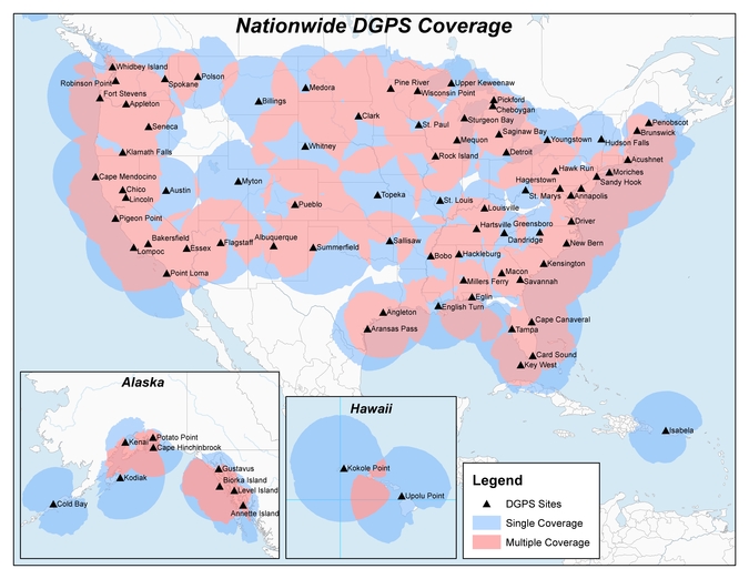
Original NDGPS coverage. -

SatNav expert Terry Moore decorated by RIN
Terry Moore Terry Moore, satellite navigation professor at The University of Nottingham, has been honored with the J E D Williams Medal for his contributions to the Royal Institute of Navigation (RIN), in particular his leading role in staging its major conferences.
Moore is a longtime member of GPS World’s Editorial Advisory Board.
His Royal Highness, The Prince Philip, Duke of Edinburgh, who is patron of the Royal Institute of Navigation, will present the award to Professor Moore at the RIN Annual General Meeting on July 19 at the Royal Geographical Society in London.
“I am really surprised and delighted,” said Moore, director of the University’s Nottingham Geospatial Institute, on the news of his award. “I have been proud to serve the RIN for many years, and it is a great honor for my small contributions to be recognized in this way.”
According to the university, Moore has now received more honors from RIN in its near 70-year history than anyone else.
In 2013, Moore earned the Harold Spencer-Jones Gold Medal — the highest honor the RIN bestows — for outstanding contributions to navigation. He was also one of the youngest recipients of the esteemed award.
Moore has also won the Richey Medal for best paper to be published each year in the Journal of Navigation in 1999 and again in 2008.
 In 2013, Moore was awarded Fellowship of the U.S. Institute of Navigation (ION) for his outstanding leadership of the navigation community, the establishment of GRACE (GNSS Research and Applications Centre of Excellence), the establishment of the Nottingham Geospatial Institute (NGI) and sustained contributions to the advancement of navigation and GNSS. He was the third Briton to receive ION Fellowship.
With a long and distinguished career devoted to teaching and research, Moore started at The University of Nottingham with a B.Sc. in civil engineering followed by a Ph.D. in space geodesy. He is now a leading researcher on positioning and navigation technologies and their numerous and varied applications.
He was promoted to the UK’s first chair of Satellite Navigation in 2001; he has completed numerous research projects funded by industry, research councils, the European Space Agency and the European Commission, and has supervised more than 25 Ph.D. students.
He has authored, or been a leading contributor to, more than 200 technical research papers published in top journals. This is in addition to being a major supporter of national and international GNSS conferences and both national and international professional and scientific bodies.
Moore is a Fellow of the Chartered Institution of Civil Engineering Surveyors, the Royal Astronomical Society and an Associate Fellow of the Remote Sensing and Photogrammetry Society.
Moore is a longstanding Fellow of the RIN, and currently its vice president.
The RIN is a learned society with charitable status formed in 1947. Its aims are to unite all those with an interest in any aspect of navigation in one unique body, to further the development of navigation in every sphere, and to increase public awareness of the art and science of navigation.
-

Russia issues stamp to honor GLONASS
A Russian stamp honoring GLONASS was issued July 5. A new Russian Federation postage stamp features the GLONASS-K satellite and graphic icons representing the main application areas of the satellite navigation system’s services. The stamp and first-day cover were officially issued on July 5.
First-day postmarks honoring GLONASS are also available for Moscow and the city of Zheleznogorsk, Krasnodar Krai.
The full orbital constellation of GLONASS consists of 24 satellites, operating in three orbital planes, with eight evenly spaced satellites on each.

First-day cover honoring the GLONASS constellation. Design: A. Povarikhin.
Face value: 19 RUB.
Size of stamp: 36.5×29 mm, size of sheet: 100×150 mm.
Form of issue: sheet with illustrated margins of 8 (2×4) stamps. Circulation: 280,000 stamps (35,000 sheets). -
Chinese BeiDou plans outlined in new white paper
A new white paper outlines plans for the Chinese BeiDou constellation, including its plans for international cooperation and exchanges.
The State Council Information Office of the People’s Republic of China published the white paper, which is titled “China’s BeiDou Navigation Satellite System,” in June.
“Navigation satellite systems are the commonwealth of the development of mankind, and also a space infrastructure which can provide all-time precise time and space information,” according to the report’s conclusion. “China will continue its BDS construction, improve the system performance, and fulfill its service commitments.”
Following is the full text of the white paper.
China’s BeiDou Navigation Satellite System
The State Council Information Office of the People’s Republic of China
June 2016Preface
The BeiDou Navigation Satellite System (hereinafter referred to as the BDS) has been independently constructed and operated by China with an eye to the needs of the country’s national security and economic and social development. As a space infrastructure of national significance, the BDS provides all-time, all-weather and high-accuracy positioning, navigation and timing services to global users.
In the late 20th century, China started to explore a path to develop a navigation satellite system suitable for its national conditions, and gradually formulated a three-step strategy of development: to complete the construction of the BDS-1 and provide services to the whole country by the end of 2000; to complete the construction of the BDS-2 and provide services to the Asia-Pacific region by the end of 2012; and to complete the construction of the BDS and provide services worldwide around 2020.
Along with the development of the BDS project and service ability, related products have been widely applied in communication and transportation, marine fisheries, hydrological monitoring, weather forecasting, surveying, mapping and geographic information, forest fire prevention, time synchronization for communication systems, power dispatching, disaster mitigation and relief, emergency search and rescue, and other fields. These products are gradually penetrating every aspect of social production and people’s life, injecting new vitality into the global economy and social development.
Navigation satellite systems are public resources shared by the whole globe, and multi-system compatibility and interoperability has become a trend. China applies the principle that “The BDS is developed by China, and dedicated to the world” to serve the development of the Silk Road Economic Belt and the 21st Century Maritime Silk Road (“Belt and Road Initiative” for short), and actively pushes forward international cooperation related to the BDS. As the BDS joins hands with other navigation satellite systems, China will work with all other countries, regions and international organizations to promote global satellite navigation development and make the BDS better serve the world and benefit mankind.
I. Goals and Principles of Development
China lays store by the construction of the BDS, ranking it one of its national key technical projects that supports its innovative development strategy.
(I) Goals of Development
Building a world-class navigation satellite system to meet the needs of the country’s national security as well as economic and social development, and providing continuous, stable and reliable services for global users; developing BDS-related industries to support China’s economic and social development, as well as improvement of people’ s living standards; and enhancing international cooperation to share the fruits of development in the field of satellite navigation, increasing the comprehensive application benefits of Global Navigation Satellite System (GNSS).
(II) Principles of Development
China upholds the principles of “independence, openness, compatibility and gradualness” in the BDS construction and development.
– By “independence,” it means to uphold independent construction, development and operation of the BDS, and acquire the capability to independently provide satellite navigation services to global users.
– By “openness,” it means to provide open satellite navigation services free of charge, and encourage all-scale, multilevel and high-quality international cooperation and exchange.
– By “compatibility,” it means to enhance BDS compatibility and interoperability with other navigation satellite systems, and encourage international cooperation and exchanges, so as to provide better services to users.
– By “gradualness,” it means to carry out the BDS project step by step, enhance BDS service performance, and boost the development of satellite navigation industry in a comprehensive, coordinated and sustainable manner.
II. Development of the BDS
Based on its national conditions, China has independently developed the BDS step by step with constant improvement.
(I) Three-Step Strategy of Development
– The first step is to construct the BDS-1 (also known as BeiDou Navigation Satellite Demonstration System). The project was started in 1994, and the system was completed and put into operation in 2000 with the launching of two Geostationary Earth Orbit (GEO) satellites. With an active-positioning scheme, the system provided users in China with positioning, timing, wide-area differential and short message communication services. The third GEO satellite was launched in 2003, which further enhanced the system’s performance.
– The second step is to construct the BDS-2. The project was started in 2004, and by the end of 2012 a total of 14 satellites – 5 GEO satellites, 5 Inclined Geosynchronous Satellite Orbit (IGSO) satellites and 4 Medium Earth Orbit (MEO) satellites – had been launched to finish the space constellation deployment. Based on a technical scheme which was compatible with the BDS-1, the BDS-2 added the passive-positioning scheme, and provided users in the Asia-Pacific region with positioning, velocity measurement, timing, wide-area differential and short message communication services.
– The third step is to construct the BDS. The project was started in 2009 to inherit the technical schemes of both active and passive services. The goal is to provide basic services to the countries along the Belt and Road and in neighboring regions by 2018, and to complete the constellation deployment with the launching of 35 satellites by 2020 to provide services to global users.
(II) Main Composition of the BDS
The BDS is mainly comprised of three segments: space segment, ground segment and user segment.
– The space segment. The BDS space segment is a hybrid navigation constellation consisting of GEO, IGSO and MEO satellites.
– The ground segment. The BDS ground segment consists of various ground stations, including master control stations, time synchronization/uplink stations, and monitoring stations.
– The user segment. The BDS user segment consists of various kinds of BDS basic products, including chips, modules and antennae, as well as terminals, application systems and application services, which are compatible with other systems.
(III) Characteristics of the BDS
The BDS development follows a model of developing regional service capacities, then gradually extending the service globally. This practice has enriched the development models for navigation satellite systems worldwide.
The BDS possesses the following characteristics: First, its space segment is a hybrid constellation consisting of satellites in three kinds of orbits. In comparison with other navigation satellite systems, the BDS operates more satellites in high orbits to offer better anti-shielding capabilities, which is particularly observable in terms of performance in the low-latitude areas. Second, the BDS provides navigation signals of multiple frequencies, and is able to improve service accuracy by using combined multi-frequency signals. Third, the BDS integrates navigation and communication capabilities for the first time, and has five major functions – real-time navigation, rapid positioning, precise timing, location reporting and short message communication services.
(IV) Improvement of BDS Performance
To meet the increasing user demand, BDS technical research and development in the areas of satellites, atomic clocks and signals will be strengthened, and a new generation of navigation, positioning and timing technologies will be explored to improve service performance.
– Providing global services. China will launch new-generation navigation satellites, develop airborne atomic clocks with enhanced performance, further improve the performance and lifetime of satellites, and build more stable and reliable inter-satellite links. It will broadcast additional navigation signals, and enhance the compatibility and interoperability with other navigation satellite systems, so as to provide better services for global users.
– Strengthening service capabilities. China will establish a grounded test and validation bed to accomplish the full coverage of tests and validation for space and ground equipment; continue to build and improve satellite based and ground based augmentation systems to substantially enhance BDS service accuracy and reliability; optimize the technical system of location reporting and short message communication to expand user volume and service coverage.
– Maintaining spatio-temporal reference. The BDT is related to the Coordinated Universal Time, and the time bias information is broadcast in the navigation message. China will push forward the clock bias monitoring with other navigation satellite systems, and improve their compatibility and interoperability. It will develop a BDS-based worldwide location identification system, increase the interoperability between BDS coordinate frame and that of other navigation satellite systems, and constantly refine the reference frame.
III. Reliable and Safe Satellite Navigation Services
China is committed to ensuring the safe and reliable operation of the BDS by taking multiple measures, and to providing continuous, stable and reliable open services to users free of charge.
(I) Ensuring Safe and Reliable BDS Operations
– Improving the management mechanism on operation. Perfecting a normalized multi-party response mechanism for BDS space segment, ground segment and user segment. Continuously enhancing the capability of assurance to manage the operation of large-scale constellations.
– Establishing a GNSS monitoring and assessment network. Constructing an international GNSS Monitoring and Assessment System, actively implementing international cooperation, extensively exploiting international resources, carrying out monitoring and assessment of the constellation status, signal accuracy, signal quality and service performance of the BDS at every scale, and providing references for users’ applications.
– Taking a redundant and backup approach. Adopting a satellite backup strategy both in-orbit and on-ground to reduce and avoid the effects of emergent in-orbit satellite fault affecting service performance. Redundant and backup design is adopted to enable ground facilities to eliminate weak links, and to enhance BDS reliability.
(II) Providing Open Services Free of Charge
Currently, B1I and B2I open service signals are being broadcast by the operating BDS-2 to provide open services to the Asia-Pacific region free of charge. The services cover an area extending 55 degrees North-55 degrees South and 55 degrees East-180 degrees East, with positioning accuracy less than 10 meters, velocity measurement accuracy less than 0.2 meter per second, and timing accuracy less than 50 nanoseconds.
(III) Disseminating BDS Information in a Timely Manner
– Publishing BDS documents related to open services and signals to provide inputs for global BDS product development efforts. The Interface Control Document of B1I and B2I signals has been published, which defines the interface specifications between the BDS-2 satellites and user terminals. It specifies the signal structures, basic characteristics, ranging codes, NAV messages and other contents. The Open Service Performance Standard has been published, which defines the service coverage area, accuracy, continuity, availability, and other performance indexes of the BDS-2. In the future, related documents will be updated and published in step with BDS construction and development.
– Establishing a multi-channel information dissemination mechanism. China holds news conferences when appropriate to disseminate important information about BDS development, and releases the latest news of the system in a timely manner through the official BDS website (www.beidou.gov.cn) from the aspects of system construction, operation, application, and international cooperation. It also issues notifications worldwide in advance before carrying out plans which might affect user services.
(IV) Protecting the Utilization of Radio-Navigation Satellite Frequency Spectrum
– Protecting the radio-navigation satellite frequency spectrum according to law. China protects the utilization of BDS frequency spectrum, and ensures the safety of BDS operation and BDS users pursuant to the national laws and regulations regarding the radio frequency spectrum.
– Firmly rejecting harmful interference. China prohibits the production, sale and use of illegal interference devices, investigates and punishes in accordance with the law any hostile interference actions which affect the system operations and services.
IV. BDS Application and Industrial Development
China strives to enhance BDS application development, in an effort to build a BDS industrial chain which comprises the basic products, application terminals, application systems and operational services, keeps strengthening BDS-related industrial supporting, promotion and innovation systems, continuously improves the industrial environment, expands the application scale for integrated development, and increases the economic and social benefits of the satellite navigation industry.
(I) Establishing an Industrial Supporting System
– Industrial policies. China has formulated development plans for the satellite navigation industry, making overall arrangement for medium- and long-term satellite navigation industrial development, and encourages competent departments and local governments to enact relevant policies to support BDS application and industrial development.
– Equitable market environment. China is making efforts to build a development environment for the satellite navigation industry marked by orderly competition, and increase the efficiency and effectiveness of resource allocation. It encourages and supports domestic and overseas organizations, including scientific research institutions, enterprises, colleges, universities and social organizations, to actively develop BDS applications, and fully release market vitality.
– Standardization process. In 2014 the National Technical Committee on BeiDou Satellite Navigation of Standardization Administration of China was established, and the BeiDou Satellite Navigation Standard System was set up, which has been constantly improved. China promotes the standards verification and implementation, and expedites the formulation and revision of standards which are fundamental, generally applicable and in urgent need, so as to enhance the quality and benefits of the procedure-based development of satellite navigation.
– Product quality system. China is working to establish and improve a public service platform for satellite navigation product quality assurance. It also actively promotes third-party quality test, type approval and authentication efforts of BDS basic products used in the security sector and application products in key fields. It is regularizing satellite navigation application services and operations, and cultivating the BeiDou brand. It aims to gradually establish satellite navigation product test and authentication institutions, strengthen admissibility of third-party certification, promoting the upgrading of the core competitiveness of BDS products on all scales, and pushing forward BDS applications in line with international conventions.
– Comprehensive service system of location data. China welcomes commercial operation to be introduced to help build the basic platform of location service based on its BDS augmentation systems, which will have extensive coverage of application fields and interconnections, and provide support services to different regions and industries and to public customers.
(II) Establishing an Industrial Application Promotion System
– Application in key sectors. Great efforts are being made to promote the application of BDS technologies and products, which are compatible with other systems, in the key sectors related to national security and economy, to provide important assurance for the steady and safe running of the national economy.
– Industrial and regional applications. China is pushing forward close integration between satellite navigation and each industry in the national economy, carrying out demonstrations of BDS industrial applications, formulating comprehensive application solutions for industries, and promoting transformation and enhancement in the areas of transportation, national land resources, disaster prevention and reduction, agriculture, forestry and water conservancy, surveying and exploration, and emergency response and rescue. It encourages BDS regional application demonstrations to meet the requirements of the state strategies on regional development, such as the “Coordinated Development for the Beijing-Tianjin-Hebei Region,” the building of “Yangtze River Economic Zone” and the development of smart cities. It is also promoting commercial and large-scale BDS applications, and enhancing BDS-related industries, as well as regional economic and social development.
– Mass market application. The goal is to produce miniaturized, low power-consuming and highly-integrated BDS-related products, oriented to the mass market in the sectors of smart phones, vehicle-borne terminals and wearable devices. The focus is on pushing forward the adoption of satellite navigation and positioning functions based on the BDS and other compatible systems as a standard configuration in the fields of vehicle-borne and intelligent navigation, and promoting diversified applications in social services, transportation, caring for vulnerable groups, and smart cities.
(III) Establishing an Industrial Innovative System
– Research and development of basic products. To make breakthroughs in key technologies, China is developing chips, modules, antennae and other basic products based on the BDS and other compatible systems, and fostering an independent BDS industrial chain.
– Establishment of an innovation system. China encourages and supports the construction and development of key laboratories for satellite navigation application technologies, research centers of engineering (technology), technology centers of enterprises, and other innovative bodies, enhances the capacity of engineering experiment platforms and achievement transformation platforms, supports relevant enterprises, and makes more efforts to protect intellectual property rights, so as to form a technology innovation system which relies on the enterprise as the main body and combines the efforts of universities, research institutes and application.
– Integrated industrial development. China encourages the integrated development of the BDS and Internet+, big data, and cloud computing, supports the integrated positioning and innovative utilization of satellite navigation together with mobile communications, WLAN, pseudo-satellites, ultra-wide band and Ad Hoc Network signals, promotes integrated development of satellite navigation and emerging industries such as the Internet of Things, geographic information, satellite remote sensing and communication, and mobile Internet, and encourages people to start their own businesses and make innovations, so as to vigorously upgrade the innovation capability of the industry.
V. International Cooperation and Exchanges
China will push forward the international development of the BDS, actively carry out international cooperation and exchanges in this field, so as to serve the Belt and Road Initiative, promote the development of global satellite navigation, and enable the BDS to serve the world and benefit mankind better.
(I) Strengthening Compatibility and Joint Applications with Other Navigation Satellite Systems
China actively pushes forward the cooperation and exchanges between the BDS and other navigation satellite systems in the fields of system construction and application from all perspectives, strengthening compatibility and interoperability, achieving resource sharing, complementarity and technology advancement, improving the services of navigation satellite systems, and providing users with more qualified, diversified, safe and reliable services.
(II) Utilizing Frequency and Orbital Slot Resources According to International Rules
As limited and valuable natural resources, frequencies and orbital slots provide a critical foundation for the development of navigation satellite systems. Adhering to the International Telecommunication Union (ITU) rules, China works to facilitate coordination of BDS frequencies and orbital slots through negotiations, actively participates in the research and formulation of ITU rules and other relevant activities, and expands radio-navigation frequency resources through cooperation with other nations. Since 2000 China has held effective coordination activities on more than 300 satellite networks with more than 20 countries, regions and international organizations.
(III) Promoting the Ratification of the BDS by International Standards
The ratification of the BDS by international standards is a milestone for the integration of the BDS into international systems. China spares no effort to get the BDS ratified by the International Organization for Standardization and other international organizations in the industrial and professional application sectors. Currently, positive efforts are being made to advance the recognition of the BDS in the International Civil Aviation Organization, International Maritime Organization, Third-Generation Mobile Communication Standard Partnership Project, and other organizations. China advocates the involvement of enterprises, scientific research, colleges and universities in the formulation of satellite navigation terminals and application standards. In November 2014 the BDS gained recognition from the International Maritime Organization.
(IV) Participating in Multilateral Activities in the Field of International Satellite Navigation
The BDS is one of the major GNSS providers, and China actively participates in international satellite navigation affairs, attends the activities held by the International Committee on Global Navigation Satellite Systems (ICG) and other relevant international organizations, supports academic exchanges and cooperation in this area, and promotes satellite navigation applications with the contribution of the BDS. China actively takes part in relevant tasks within the orbit of the United Nations, successfully held the Seventh Meeting of the ICG in 2012, when the proposals for the international GNSS Monitoring and Assessment and the BDS/GNSS Application Demonstration and Experience Campaign were initiated, and the Joint Statement of Global Navigation Satellite Systems for serving the whole was issued. The China Satellite Navigation Conference is held annually, and plays a positive role in the development of satellite navigation technologies and applications worldwide.
(V) Promoting International Satellite Navigation Applications
– To intensify publicity and popularization in this field, China has implemented the “BDS Tour” series of events, pushed forward the establishment of BDS Centers to enable better understanding of the BDS. BDS Centers have been jointly set up in a number of nations. The BeiDou International Exchange and Training Center has been opened, and a demonstration platform for education and training in the field of satellite navigation has been set up. In addition, academic education, summer schools, short-term training courses and symposiums, and other international education and training activities have been regularly held.
– To advance and implement internationalization projects, China is promoting research and consultancy services regarding the policies, markets, laws and finance related to international satellite navigation applications, and improving comprehensive international service capabilities. In line with the Belt and Road Initiative, China will jointly build satellite navigation augmentation systems with relevant nations, provide highly accurate satellite navigation, positioning and timing services, improve the overseas BDS service performances, and promote international applications of navigation technologies. China will also carry out application demonstrations in the fields of transportation, tourism, maritime application, disaster reduction and relief, and agriculture, and boost application on a large scale, through establishing an operation and service platform for highly accurate satellite navigation, positioning and timing services.
Conclusion
Navigation satellite systems are the commonwealth of the development of mankind, and also a space infrastructure which can provide all-time precise time and space information. They promote the development of emerging industrial clusters that are technology- and knowledge-intensive with huge growth potentials and sound comprehensive benefits, thus becoming critical support for national security, economic and social development, and increasingly improve the people’ s production and living activities.
China will continue its BDS construction, improve the system performance, and fulfill its service commitments. It will persist in opening up and cooperation, promote the popularization in this field, strive to advance satellite navigation applications worldwide, and make satellite navigation better benefit the wellbeing of the people and the progress of mankind.
-
Geospatial World Forum looks at Galileo, EGNOS for GIS

Tim Reynolds By Tim Reynolds
Contributing Editor for EuropeThe eighth edition of the Geospatial World Forum took place May 23–26 in Rotterdam, The Netherlands, attracting professionals from the surveying and geospatial information system (GIS) sectors. I attended the event on May 24 and took part in a workshop that looked at the benefits of Galileo and EGNOS in geospatial applications in the context of the imminent launch of Galileo initial services.
An industry survey undertaken by the GSA indicates that already more than 80 percent of GNSS receivers for surveying and mapping use are EGNOS-enabled, while 77 percent of geospatial reference network providers have enough information to upgrade Galileo and will be ready to provide a service by 2017. All good news. On the less positive side, more than 60% of professional surveyors did not know about EGNOS!
The workshop also talked up the potential for synergies between Galileo GNSS and Copernicus Earth Observation (EO) systems — a topic of immense interest at the European Space Solutions as well. Hans Dufourmont from the European Environment Agency (EEA) highlighted the use of GNSS to track animal species and monitor migration paths when considering development opportunities. He saw a huge potential for synergies between geopositioning and surface imaging going forward.
Maurice Barbieri, president of the Council of European Geodetic Surveyors (CLGE), also saw a “clear role for Galileo” in the surveying community with its potential ability to meet centimeter accuracy requirements much more than for EGNOS.
He also speculated about the value of establishing a European Geoinformatic Agency that might coordinate the provision of European GNSS and EO data. He felt the private business community would appreciate such simplification.


