IGS Workshop 2016 will be hosted at the University of New South Wales in Sydney, Australia. The IGS invites the GNSS community to participate in a week of presentations, discussions, meetings and events with the theme of “GNSS Futures.”
Abstracts are being accepted until Nov. 25. In particular, the co-chairs of the session “Scientific uses of IGS data and products” is seeking submissions. Both oral and poster presentations are welcome; oral presentation deadline is Nov. 25, and poster submissions will be accepted until Dec. 16.
Co-chairs Matt King and Tilo Schӧne offer the following description of the session:
IGS data and products are now used within a huge range of scientific applications, including studying kinematics of satellites, glaciers, surface reflectometry, ionospheric and tropospheric perturbations, time-transfer and solid Earth deformation over timescales of seconds to decades. This session welcomes presentations focused on the application of IGS data and products to address scientific problems of all kinds. Presentations that consider future needs and applications as well as present applications are especially welcome.
The next GLONASS-M satellite will be launched on Dec. 29, according to Russian news agency TASS.
GLONASS-M 51 will replace a satellite put into orbit in 2005, which has exceeded its design life by three years. The lifetime of a GLONASS-M is approximately seven years.
In addition, not earlier than February, a trio of GLONASS-M satellites is expected to be launched.
GLONASS-M 51 is now undergoing electrical tests, scheduled until mid-November. Then it will be placed in an installation shipping container and sent to the launchpad at the Plesetsk Cosmodrome in northern Russia.
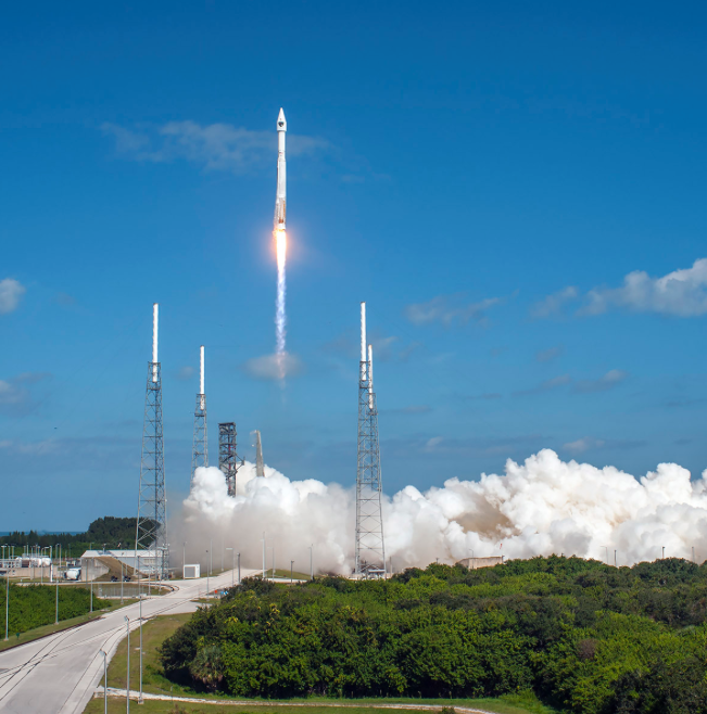
The U.S. Air Force successfully launched its 11th and next-to-last Boeing-built Global Positioning System GPS IIF series satellite aboard a United Launch Alliance Atlas V 401 launch vehicle from Space Launch Complex 41, Cape Canaveral Air Force Station, Fla., on Oct. 31 at 12:13 p.m. EDT (9:13 a.m. PDT).
GPS IIF satellites provide improved signals to support both the warfighter and the growing civilian needs of a global economy. Featuring a new operational third civil signal — L5 — that benefits commercial aviation and safety-of-life applications, the GPS IIF series provides improved accuracy through advanced atomic clocks, a longer design life than previous GPS satellites on orbit.The GPS constellation is healthy, stable and robust with two GPS IIAs, 12 GPS IIRs, seven GPS IIR-Ms and 10 GPS IIF satellites on orbit providing precise global positioning, navigation, and timing services to users around the globe.
Colonel Steven P. Whitney.
“The successful outcome of today’s mission is due to the tremendous commitment of a world class team focused on mission success,” said Col. Steve Whitney, director of the Space and Missile Systems Center’s (SMC) GPS Directorate. “I am pleased to say it’s truly an honor and privilege to be part of a mission that plays such a critical role in our nation’s infrastructure. To the men and women of SMC, the 45th, 50th, 310th Space Wings, Boeing, United Launch Alliance, The Aerospace Corporation, GPS IIF and the Atlas V launch teams, thank you!”
“The GPS IIF satellites play a key role in our modernization effort to provide new space-based capabilities for users around the globe and for decades to come,” said Lt. Gen. Samuel Greaves, SMC commander and Air Force Program Officer for Space. “The successful outcome of today’s mission is due to the tremendous commitment of a world-class team focused on mission success.”
“As the nation’s premier gateway to space, we are proud to be part of the team providing GPS and its capabilities to the world,” said Brig. Gen. Wayne Monteith, 45th Space Wing (Patrick Air Force Base, Fla.) commander, who served as the Launch Decision Authority. “GPS IIF-11 was the 16th launch this year for the wing. Our team diligently prepared for this important mission through a series of rigorous rehearsals, readiness reviews and pre-operational checkouts. Together, with the Space and Missile Systems Center and our industry partners, we make up one team delivering assured space launch and combat capabilities for the nation.”
The integrated team is now preparing GPS IIF-12, the last model of the series, scheduled for launch on Feb. 3, 2016. An airmen-led processing team at Cape Canaveral has processed every launch of the series since GPS IIF-1 launched there in May 2010.
Operated by Air Force Space Command’s 50th Space Wing at Schriever Air Force Base, east of Colorado Springs, Colo., the GPS constellation provides precise positioning, navigation and timing services worldwide as a free service provided by the U.S. Air Force, seven days a week, 24-hours a day.
Major General David Thompson announces a 24-hour delay for the launch of the eleventh GPS-IIF satellite.
Major General David Thompson, Vice Commander, U.S. Air Force Space Command, announced this morning that the GPS IIF launch scheduled for today will be delayed for 24 hours due to a water deluge suppression system at the launch site. Launch should only be delayed for 24 hours.
The water deluge suppression system is a launch site safety issue. Officials made the call on Thursday evening to postpone the launch to correct a leak discovered in a ground support equipment valve for the launch pad water suppression system. The valve will require repair or replacement.
The 19-minute launch window on Saturday extends from 12:13 to 12:32 p.m. EDT (1613-1632 GMT).
A United Launch Alliance Atlas V 401 will launch the GPS IIF-11 mission for the U.S. Air Force on Saturday, Oct. 31, from Space Launch Complex-41 at Cape Canaveral Air Force Station, Fla.
GPS IIF-11 is the second to last of the Block IIF satellites, incorporating improvements to provide greater accuracy, increased signals, and enhanced performance for users.
The GPS IIF satellites deliver second civil signal (L2C) for dual-frequency equipment, and a new third civil signal (L5) to support commercial aviation and safety-of-life applications. The next generation of GPS satellites is GPS III.
GPS IIF-11 will be the third GPS mission ULA launches in 2015. GPS IIF-9 launched on a Delta IV in March, and GPS IIF-10 launched in July. This mission will be ULA’s 11th in 2015 and 102nd since the company was founded in 2006.
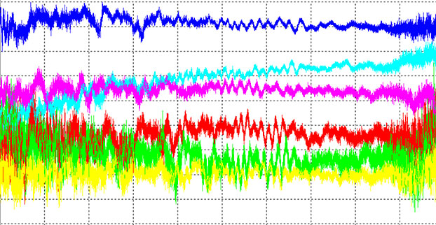
China’s new third-generation BeiDou satellites are broadcasting some new signals in space. The newest signal, which just began broadcasting from a satellite launched on Sept. 30, is similar to the future GPS L1C signal with time-division BOC(1,1) and BOC(6,1) signals. Such a type of modulation is called time-multiplexed binary offset carrier (TMBOC, see note below).
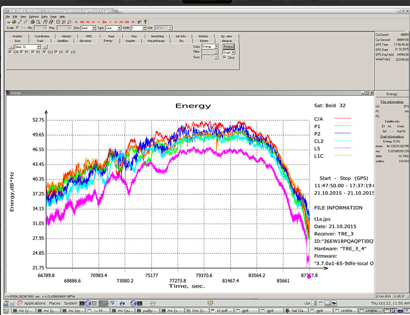
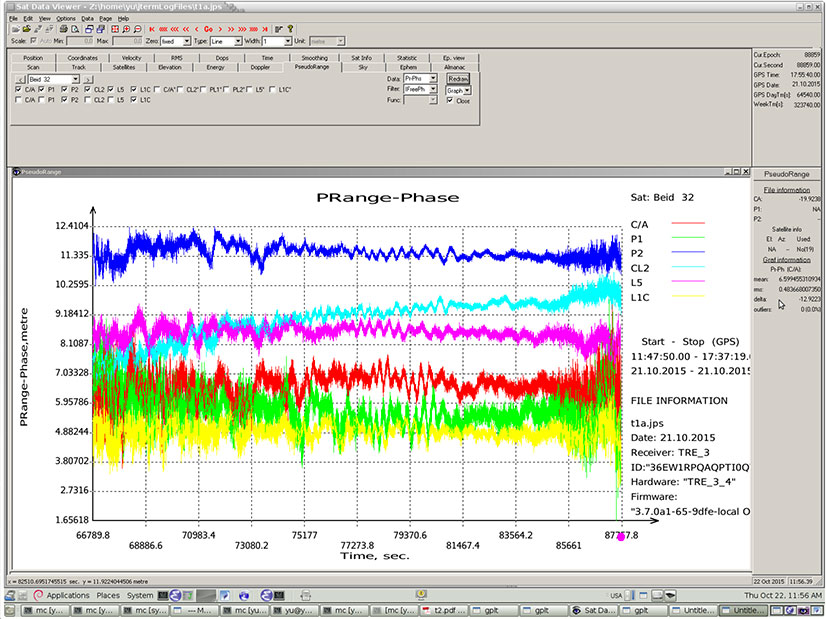
Researchers at JAVAD GNSS have been tracking the new signals, particularly those from Beidou-3 I2S, an inclined geosynchronous orbit (IGSO) spacecraft, NORAD number 40938. I2S is transmitting on three frequency bands.
In addition, new signals on 1575.42+1.023*14 MHz (B1-2), 1176.45 MHz (E5A) and 1207.14 (E5B) frequencies for three satellites (PRN 32, 33, 34) also have been decoded and tested.
The following graphs illustrate the experiment:
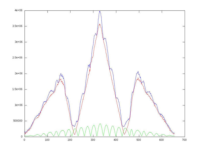
I of BOC(1,1) (red), BOC(6,1) (green) and their sum (blue) vs code shift.
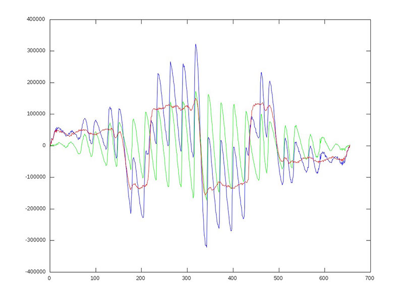
dI of BOC(1,1) (red), BOC(6,1) (green) and their sum (blue) vs code shift.
Horizontal axis: 0 – minus one chip shift; 327 – zero shift; 655 – plus one chip shift
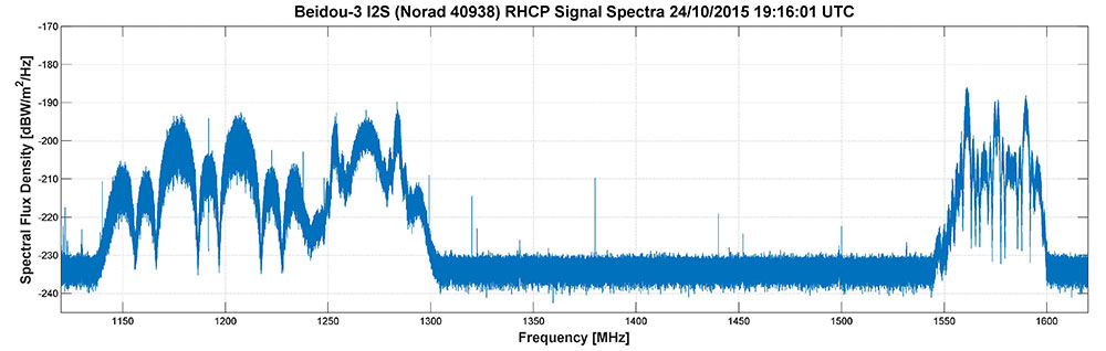
Researchers Steffen Thoelert, Oliver Montenbruck and Michael Meurer from the Deutsches Zentrum für Luft- und Raumfahrt (DLR, German Aerospace Center) have also been busy tracking the newest BeiDou IGSO satellite. The following diagram shows a spectral measurement of the complete GNSS L-band frequency range, which shows the signal transmissions on B1, B2 and B3 band. The signal was captured with DLR’s high-gain antenna in Weilheim, operated by the DLR German Space Operations Center in Oberpfaffenhofen.
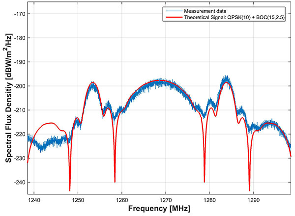
In comparison to the two latest Beidou-3 MEO satellites, launched on July 25, the IGSO has an additional signal on the B3 band. The MEO satellites transmit only the QPSK(10) while the new IGSO also transmits an additional BOC(15,2.5) signal. The following picture shows the B3 frequency band separately including a combined theoretical signal (QPSK(10)+BOC(15,2.5)).
The newest BeiDou satellite is the first in that constellation equipped with a hydrogen maser atomic clock. A series of tests related to the clock and a new navigation-signal system will be undertaken.
China plans to expand the BeiDou services to most of the countries covered in its “Belt and Road” initiative by 2018, and offer global coverage by 2020.
Earlier this year, China stated that one of the July-launched MEO satellites was working autonomously and had set up a link with the other satellite, successfully testing the autonomous control technology of the Beidou constellation. The inter-satellite link realizes communication and distance measurement among satellites, bringing autonomous control of the system a step closer.
Autonomous navigation is the project’s key to global operation. It enables satellites to work independently, providing users with more accurate data, according to BeiDou design engineers.
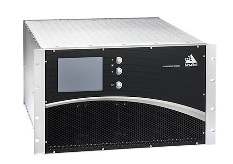
The U.S. Federal Aviation Administration (FAA) and NovAtel have exercised a bilateral option to produce a Wide Area Augmentation System (WAAS) G-III—Galileo prototype receiver. Maintaining core NovAtel WAAS G-III functionality for GPS and SBAS signal processing, the new receiver will operate in the WAAS reference station test environment to facilitate research on multiple GNSS constellation utilization.
The prototype receiver will also add functionality to support tracking and demodulating associated navigation data for Galileo satellites including:
Galileo E1 and E5a tracking
Ephemeris and almanac reporting/processing from E1 or E5a
Automatic channel assignments
Time solution computed from Galileo
Correlator information for signal deformation on Galileo signals
The WAAS G-III—Galileo prototype receiver will be developed on NovAtel’s existing WAAS G-III receiver hardware and application software, and delivered as a field-loadable firmware package. The WAAS G-III—Galileo receiver will not be qualified to DO-178B Level D as part of this contract.
NovAtel’s WAAS G-III reference receiver platform was designed with expandability and multi-GNSS SBAS evolution in mind, and can be customized to meet the needs of individual satellite networks. NovAtel has already delivered G-III based reference receivers to several programs worldwide, including the WAAS G-III receiver (US WAAS, FAA), IRIMS G-III receiver (India IRNSS, ISRO), and QZSS G-III receiver (Japan QZSS, NEC) variants.
The company’s reference receivers and uplink station equipment have been a central element of the U.S. WAAS since its inception. The WAAS third-generation reference receiver (G-III) uses fully updated hardware, and tracks all GPS signals including the legacy GPS L1 C/A, L2P(Y) (semi-codeless), and the modernized L2C, L5, L1C signals as well as the WAAS L1 C/A and L5 signals.
The WAAS G-III reference receiver provides a rich set of range measurement data, signal integrity metrics, and logs for processing by the system’s data communication processor, NovAtel said. The WAAS G-III – Galileo prototype receiver is the first G-III platform evolution for the FAA, an important step towards possible GPS + Galileo dual-GNSS SBAS operations in the future.
In addition, new signals on 1575.42+1.023*14 MHz (B1-2), 1176.45 MHz (E5A) and 1207.14 (E5B) frequencies for three satellites (PRN 32, 33, 34) also have been decoded and tested.
Here are graphs illustrating the experiment:
I of BOC(1,1) (red), BOC(6,1) (green) and their sum (blue) vs code shift.
dI of BOC(1,1) (red), BOC(6,1) (green) and their sum (blue) vs code shift.
Horizontal axis: 0 – minus one chip shift; 327 – zero shift; 655 – plus one chip shift
A UAV project, POSEIDRON, took top honors in the 2015 European Satellite Navigation Competition, which recognizes the year’s best innovations in commercial applications of satellite technology. POSEIDRON won over the international jury of experts with its remote-controlled multicopter built to support maritime search-and-rescue services — and took home the grand prize ahead of the European Satellite Navigation Competition’s 29 other winners.
The award ceremony took place during the Satellite Masters Conference. The ceremony was held at the ddb forum in Berlin Oct. 20. The awards ceremony was held in conjunction with the Copernicus Masters awards for Earth observation.
Thorsten Rudolph, Ulrike Daniels (both Anwendungszentrum GmbH), David Argiles (ValSpace Consortium), Rudesindo Hernando Meliá, Maria Dolores Albiol Simo, Manuel Pedreira Gimenez, Jorge Esteve Ripollés and Enrique Martínez Asensi (all Sincratech Aeronautics) and Dorothee Bär (German Federal Ministry of Transport and Digital Infrastructure (BMVI)). (Photo: Anna Kreuz)
Enrique Martínez Asensi and his winning team hope to see Poseidron save lives far out at sea when people fall overboard or are involved in shipwrecks that occur during illegal immigration. Custom-developed by Sincratech Aeronautics — a start-up based in Valencia, Spain — POSEIDRON can be launched from ships or platforms under virtually any weather conditions. The multicopter uses thermal cameras and the European positioning service EGNOS to quickly locate people in the water and transmit an alarm to rescue teams along with precise information. Capable of carrying up to 70 kilogrammes, it can also transport a dinghy and deploy it as soon as casualties are found. This is what makes POSEIDRON both faster and more cost-effective than other rescue systems, which in turn significantly increases the chances of survival — particularly in cold waters.
In addition to winning the ESNC’s EUR 20,000 grand prize, the innovative project will now have the chance to enter a 12-month incubation programme at one of five Science Parks in Valencia as part of the region’s prize.
The ESNC set a new participation record this year, with 515 innovations entered by companies from more than 40 different countries around the world. The competition more than matched the successes of past editions in increasing its overall figures to 272 winners awarded and 3,343 ideas received from more than 10,000 participants throughout its 12 years in existence.
“Time synchronization and reliable positioning information are essential to today’s digital economy: Without corresponding satellite-based services, the development of these and other innovations — including the Internet of Things, machine-to-machine communication, and Industry 4.0 — would not be possible,” explained Thorsten Rudolph, CEO of ESNC initiator and organiser Anwendungszentrum GmbH Oberpfaffenhofen. “As the ideas submitted to this year’s ESNC have shown to impressive effect, it is these forward-thinking technologies in particular that present a great deal of potential waiting to be unleashed by high-tech start-ups.”
Under the patronage of the German Federal Ministry of Transport and Digital Infrastructure (BMVI), the ESNC presented prizes valued at approximately EUR 1 million in total at its festive Awards Ceremony.
The competition’s jury of 240 renowned experts selected both the overall victor and 30 other regional and special prize winners. With their innovations in areas such as connected mobility, smart cities, tourism and environmental protection, these entrants demonstrated how fundamental precise satellite navigation signals are to Europe’s digital society.
2015 Winners
Overall Winner
Loles Albiol Simó, Rudesindo Hernando Meliá, Jorge Esteve Ripollés, Manuel Pedreira Giménez, Enrique Martinez Asensi :: OVERALL WINNER – Valencian Community / Spain POSEIDRON: Remotely Piloted Aircraft System for Search and Rescue and Environmental Defence
Special Prize Winners
Rafael Olmedo, Juan Domingo, Laura Concepción :: GSA
KYNEO: The Open Navigation Platform for the GNSS of Things (Read more abut this prize here.)
Su Zhenzhong, Tonio Gsell, Alexander Wolf :: ESA
RTKNAV – A Low-Cost, Compact, User-Friendly, Centimetre-Accurate, Real-Time Navigation Solution
Dariusz Tanajewski, Grzegorz Grunwald :: DLR
Mobile Underwater Positioning System (MUPS)
Jukka Talvi, Joni Jämsä, Kalle Arola, Jukka-Pekka Alanissi, Antti Koponen :: BMVI/BMWi
HALI – Always Green Traffic Signals for Emergency Vehicles
Prof Dr Nick van de Giesen, Dr Eugenio Realini :: University Challenge
GNSS Monitoring of Precipitable Water Vapour over East Africa Using Low-Cost Receivers
Jasper Ettema, Sabine Ettema :: GNSS Living Lab
Position-Based Assistance in Case of Sudden Cardiac Arrest
Regional winners
Suresh Babu Mandalanka :: Asia
GeoKey – A Locking System That Uses Geographic Locations as Keys
Jasper Ettema, Sabine Ettema :: Austria
Position-Based Assistance in Case of Sudden Cardiac Arrest
Dr Walter Naumann :: Baden-Württemberg / Germany
ICARUS – A New Global Tracking Service for Small Objects
Ladislav Bartuška :: Czech Republic
Biological Protection of Airports Using Drones
Ronny Webers, Bart Lenaerts, Vincent Jorissen :: Flanders / Belgium
JobWalkr – The First Mobile App That Informs You About Job Opportunities in Your Neighbourhood
Daniel Neveux D’Agata, Laurent Kerbrat, Maïwenn Penhouët :: France
WIZAR – A new way to discover history and heritage
Alberto Gonzalez, Antonio Vazquez, Bibiano Fdz-Arruti, Aaron Nercellas, Diego Hurtado, Diego Nodar, Fernando Aguado, Franco Pérez :: Galicia / Spain
Point&Pin – Remote Localisation for Emergency Situations
Oscar Serradilla :: Gipuzkoa / Spain
Pothole Avoider
Sibylle Geiger, Jens Liebau, Nezar Mahmoud :: Hesse / Germany
Discover a Great Variety of Local Foods with the frimeo App
Aidan Flanagan, Colm Murphy :: Ireland
112GPS.com – More accurate emergency calls
Ronen Bitan, Tal Lavi :: Israel
Trailze – Complete Outdoors Experience
Dr Saulius Rudys, Mantautas Rudys :: Lithuania
Fully Camouflaged GNSS-GSM Anti-Theft System for Bicycles
Carlos Callejero Andrés, Julio Pantoja Dominguez, Ignacio Gómez Maqueda :: Madrid / Spain
VardiaN – Big Data Platform of Connected PPEs to Prevent Accidents in Hazardous Environments
Prof Dr Nick van de Giesen, Dr Eugenio Realini :: The Netherlands
GNSS Monitoring of Precipitable Water Vapour over East Africa Using Low-Cost Receivers
Thomas Jelle, Ingjard Sandhei, Åsmund Tokheim, Dag Jomar Mersland, Morten Tvenning, Iván Sánches Ortega, Robert Badnall :: Norway
MazeMap – High-quality, interactive, searchable, and linkable indoor maps
Jan Filipowiak, Radoslaw Jastrzebski, Maciej Glowacki :: Poland
Pastguide: Virtual Reality in Real Places
Florin Banica, Andreea Diana Banica :: Romania
Shared Ahead – A Truck-Sharing System
Su Zhenzhong, Tonio Gsell, Alexander Wolf :: Switzerland
RTKNAV – A Low-Cost, Compact, User-Friendly, Centimetre-Accurate, Real-Time Navigation Solution
Zoe Farrington, Andrew Richardson :: United Kingdom
REALRIDER®
Loles Albiol Simó, Rudesindo Hernando Meliá, Jorge Esteve Ripollés, Manuel Pedreira Giménez, Enrique Martinez Asensi :: Valencian Community / Spain
POSEIDRON: Remotely Piloted Aircraft System for Search and Rescue and Environmental Defence
Nicolas de Kerchove, Joel Mendez, Oscar Marí :: Wallonia / Belgium
A New Concept for a Location-based Mobile Game with an Innovative Monetisation Platform
WASHINGTON – On Friday, Oct. 16, the GPS Innovation Alliance (GPSIA) submitted two filings regarding federal spectrum policy. Comments were filed in response to a public notice in the U.S. Department of Transportation’s (DOT) GPS Adjacent Band Compatibility assessment, and testimony was submitted for the record to a U.S. House Energy and Commerce subcommittee in response to its recent hearing, “Improving Federal Spectrum Systems.” Both filings stressed that the “1 dB standard” is the appropriate criterion for testing the compatibility of terrestrial broadband and GPS operations.
The GPS Innovation Alliance has consistently supported the more complete use of underused spectrum where technically feasible. In both filings, GPSIA expressed support for each government entity’s ongoing efforts and stressed the importance of protecting GPS, one of the country’s most important and ubiquitous national utilities.
Regarding the DOT effort, GPSIA offered suggestions relating to certain aspects of the proceeding and voiced support for the “1 dB standard” in testing — which would determine Adjacent Band Masks based on a measurement of received interference test signal power levels that cause a 1 decibel (dB) degradation in the receiver’s Carrier-to-Noise Density Ratio. As outlined in GPSIA’s comments, the organization’s support for the 1 dB standard is based on its long and well-established history in international and domestic regulatory proceedings and difficulties associated with other standards.
GPSIA wrote: “While DOT has proposed recording other performance metrics, such as loss of signal lock or degradation of pseudo-range or position accuracy, GPSIA believes these are inappropriate metrics for interference assessment since their inherent basis is an interference level that seriously degrades the RNSS spectrum environment and causes significant disruption to GPS receivers.”
Degradation of accuracy or otherwise attempting to determine effects on the “user experience” are not practicable interference metrics, and DOT should rely upon the 1 dB protection criteria in derivation of the Adjacent Band Masks. GPS receivers are used in a tremendous range of end user applications beyond simple navigation. It is unclear how it would be possible to determine whether there has been “material degradation” in the functioning of this wide range of GPS applications, much less what constitutes degradation that is “material.”
GPSIA also submitted testimony for the record in response to an Oct. 7 hearing by the House Subcommittee on Commerce and Technology, where the potential for repurposing spectrum currently reserved for use by satellite applications for terrestrial broadband was discussed, but without addressing the difficult technical challenges associated with repurposing satellite spectrum.
A key theme raised in the GPSIA testimony is support for allocating similar uses for spectrum in close proximity to each other. Doing so is an approach that is preferable to adopting receiver standards. GPSIA also explained the unique technical differences between communications and navigation spectrum use.
“A straightforward approach is to minimize the number of dissimilar spectrum applications in close spectral proximity to each other,” GPSIA said. “Put another way, similar spectrum uses should be grouped together to the greatest extent possible to minimize the number of band edges or ‘border areas’ where dissimilar uses in close proximity create serious interference challenges. This approach minimizes the need for the FCC to engage in extensive rule making to balance the interests of dissimilar spectrum uses in every spectrum ‘border’ area.”
GPSIA then noted that “attempts to attribute Global Navigation Satellite System (GNSS) interference issues mainly to poor receiver design are misguided. The FCC has long understood that receivers designed to receive one set of frequencies can be ‘overloaded’ by transmissions in adjacent frequencies.”
In fact, overload interference is not unique to GPS, whose receivers are typically designed to withstand adjacent band transmissions hundreds of millions of times stronger than GPS signals and compare favorably to other common types of mass market receivers.
GPSIA again voiced support for the 1 dB standard for testing, explaining that communications systems operate above the noise floor spectrum while GPS signals are below the thermal noise floor when they are received.
“Because GNSS operates below the noise floor, the most appropriate means by which to assess the potential of new adjacent band systems is whether the new service causes a 1 dB degradation in a receiver’s Carrier-to-Noise Ratio.” Other interference metrics, the GPSIA explained, “are based on interference levels that seriously degrade the GNSS spectrum environment and will cause devastating disruption to GPS receivers.”
“Use of a 1 dB standard is vastly superior to an approach that attempts to assess whether there is ‘actual’ harm to an incumbent service, which wrongly assumes that you can accurately predict the impact of a new service across a heterogeneous series of devices in adjacent spectrum. Defining harmful interference by reference to a level of degradation to a particular key performance indicator among a limited universe of devices and applications fails to account for and support future innovation, including known and currently unknown applications which could take advantage of ever increasing accuracy of the position, navigation and timing functions of GPS. Use of a defined change in the noise floor (1 dB) provides a readily identifiable and predictable metric that all interested parties can take into account now and in the future.”
GPSIA’s testimony concluded by urging policy makers to engage in “rational, long term spectrum planning,” noting that a focus solely on regulation of receiver characteristics is likely to have limited usefulness and may be inefficient and harmful to continued innovation in affected spectrum uses.
The GPS Innovation Alliance recognizes the ever increasing importance of Global Positioning System (GPS) and other Global Navigation Satellite System (GNSS) technologies to the global economy and infrastructure and is firmly committed to furthering GPS innovation, creativity and entrepreneurship. The GPS Innovation Alliance seeks to protect, promote and enhance the use of GPS. For more information, visit www.gpsalliance.org.
Site of the symposium is the Ecole Nationale de l’Aviation Civile (ENAC). The symposium is organized by ENAC in cooperation with the Centre National d’Etudes Spatiales Communautés de Compétences Techniques Positionnement et Datation par Satellite (CNES CCT PDS).
A United Launch Alliance Atlas V 401 will launch the GPS IIF-11 mission for the U.S. Air Force on Friday, Oct. 30, from Space Launch Complex-41 at Cape Canaveral Air Force Station, Fla.
GPS IIF-11 is the second to last of the Block IIF satellites, incorporating improvements to provide greater accuracy, increased signals, and enhanced performance for users.
The GPS IIF satellites deliver second civil signal (L2C) for dual-frequency equipment, and a new third civil signal (L5) to support commercial aviation and safety-of-life applications. The next generation of GPS satellites is GPS III.
GPS IIF-11 will be the third GPS mission ULA launches in 2015. GPS IIF-9 launched on a Delta IV in March, and GPS IIF-10 launched in July. This mission will be ULA’s 11th in 2015 and 102nd since the company was founded in 2006.
A quality assurance team from the 45th Launch Group off-loads a GPS IIF-12 satellite from a C-17 Globemaster III on Cape Canaveral Air Force Station, Fla., Oct. 8. (U.S. Air Force photo/James Rainier)
The last Air Force GPS IIF in a block of 12 satellites was delivered to Cape Canaveral Air Force Station, Florida, from Boeing’s manufacturing facility in El Segundo, Calif., Oct. 8 via a C-17 Globemaster III.
A crowd from the government and industry partnership, who will complete the satellite’s final assembly, gathered on the Cape’s “Skid Strip” to watch the off-loading of the satellite they will prepare to launch aboard a United Launch Alliance rocket in 2016.
“This GPS IIF-12 satellite represents the end of a legacy as it will be the last of the 61 GPS satellites processed here at (Cape Canaveral Air Force Station),” said Brig. Gen. Wayne Monteith, the 45th Space Wing commander. “This culminates an incredible 27-year legacy at our Area 59 Satellite Processing Facility. We are the nation’s premier gateway to space and are humbled to be a part of the team that provides GPS and its capabilities to the world.”
Although there have been other models of GPS launched into space, the Airmen-led processing team at Area 59 is particularly proud to begin preparations to send the last IIF block satellite into orbit. They’ve been behind every launch of the series since the first GPS IIF launched here in May 2010.
“Our combined team’s objective is 100 percent mission success each and every time,” said Col. Eric Krystkowiak, the 45th Launch Group commander. “My Airmen work, in partnership, with Boeing and the system program office at the Space and Missile Systems Center throughout the final stages of satellite processing prior to launch. From spacecraft containerization, shipment from California, the arrival at the Cape Canaveral Air Force Station Landing Strip, final checkouts, fueling and encapsulation, the team is laser focused on identifying and mitigating any issues that could potentially jeopardize mission success.”
The Boeing-assembled GPS IIF 12 that arrived at the Cape Canaveral will undergo a series of prelaunch preparations, checks and rehearsals. These included functional checkout of the spacecraft, compatibility testing, battery installation, fueling, mating to the payload adapter and obtaining a final flight weight.
Members of the quality assurance team range from young military officers to career enlisted troops and seasoned civilians.
“Mission assurance at the launch base is executed with our ‘triad’ of professionals,” Krystkowiak said. “Our mission assurance technicians are enlisted personnel with many years of experience in missile maintenance who are fully engaged and observe the contractor’s work with the satellite. They bring their hands-on experience, strict technical compliance and discipline to the satellite processing realm. Beside them are our company grade officers and civilian engineers who bring their engineering rigor and innovative ideas into the process. Lastly are our Aerospace Corporation partners who provide invaluable experience and legacy system insight to the team with their continuity of satellite processing. Many of these members have been here at the Cape since GPS first launched in 1989 and achieved full operational capability in 1995.”
A field program manager for the team interfaces with 45th SW leadership, the Air Force SMC and the contracted partners throughout the months in between the satellite’s delivery and its launch.
The Evolved Expendable Launch vehicle is used to launch GPS satellites from Cape Canveral into nearly 11,000-mile circular orbits. While circling the Earth, GPS satellites transmit extremely accurate timing data on multiple L-band frequencies. Design life across the satellite blocks range from 7.5 to 12 years, but many are lasting more than 20 years, with the oldest vehicle turning 25 in November.
The GPS Master Control Station, operated by the 50th SW’s 2nd Space Operations Squadron at Schriever Air Force Base, Colo., is responsible for monitoring and controlling the GPS as a 24-satellite system, consisting of six orbital planes, with a minimum of four satellites per plane. There are currently 39 vehicles in the GPS constellation.