Signals from both Galileo satellites launched March 27 are now transmitting signals.
Researchers at Université de Liège and at the German Aerospace Center (Deutsches Zentrum für Luft- und Raumfahrt, or DLR) reported on May 21 that the first of the full-operational-capability (FOC) satellites had begun transmitting standard L-band signals. The satellite, designated Galileo 8, is using pseudorandom-noise-code identifier 22.
The first E1 and E5 signals from Galileo 8 were received at an International GNSS Service Multi-GNSS Experiment tracking station in Windhoek, Namibia, at about 11:32 UTC on May 21. The satellite’s signals were subsequently tracked by a station in Wettzell, Germany, and then by others.
The other satellite, Galileo 7, began transmitting standard L-band signals on May 25. The first E1 and E5 signals from Galileo 7 were received around 17:00 UTC. The satellite is using PRN code 26.
The signals will be set unhealthy for use until satellite commissioning is completed.
Galileo 7 is also known as GSAT0203, FOC-FM3 and as NORAD object 40544. Galileo 8 is also designated GSAT0204, FOC-FM4 and NORAD object 40545.
The coming leap second on June 30 sounds as scary as the (turns out not-so-scary) Y2K bug. But the world has experienced leap second issues before, and most affected industries are taking steps to prepare.
The world’s clocks will be adjusted by one second on June 30, when a leap second will be inserted into Coordinated Universal Time (UTC), the standard international time scale. In theory, all UTC clocks should insert a second labeled 23h 59m 60s (the leap second) following one labeled 23h 59m 59s UTC. This is equivalent to having all of the clocks in the world stop for one second at that time, as explained in May’s Expert Advice column.
A problem with some GPS receivers implementing the extra second caused the U.S. Civil GPS Service Interface Committee (CGSIC) to issue a notice in February. But GPS receivers aren’t the only thing that could be affected.
The Wall Street Journal is reporting that financial regulators and market participants are worried enough about the leap second that they’re planning for potential disruptions. The adjustment could present technical difficulties for traders and exchanges, as some computers might not be programmed to account for the adjustment, according to a Dow Jones report.
“These guys are agonizing over it,” Steve Allen, a programmer-analyst at the University of California’s Lick Observatory, told Dow Jones. “It is definitely a hassle.”
A U.S. Commodity Futures Trading Commission spokeswoman said that “For the most part, we’re not too worried,” told Dow Jones. “But of course as the regulator, we do need to ensure folks are ready.”
The last leap second occurred on June 30, 2012, and that leap second caused technical problems for websites and computing systems — including Reddit, Mozilla, Gawker, FourSquare, Yelp and LinkedIn.
Google had prepared ahead of time and was unaffected. Google gradually adds a couple of milliseconds to its servers’ clocks throughout the day when a leap second is to occur. According to a 2011 Google blog, “We modified our internal NTP servers to gradually add a couple of milliseconds to every update, varying over a time window before the moment when the leap second actually happens. This meant that when it became time to add an extra second at midnight, our clocks had already taken this into account, by skewing the time over the course of the day.”
But many web services didn’t follow Google’s lead in 2012 and experienced disruptions. Qantas‘ computer system went down for hours, forcing employees to check in passengers by hand. For background on the 2012 event, and a good explanation on the reason for a leap second, read “Time to Get in Sync” by Richard Langley, GPS World Innovation editor.
Amazon Web Services said it plans to “implement alternative solutions to avoid the ‘:60’ leap second. This means that AWS clocks will be slightly different from the standard civil time for a short period of time.”
In the U.S., stock exchanges such as the New York Stock Exchange and Nasdaq are working around the leap-second time (8 p.m. in the U.S.) by closing its after-hours trading a half-hour early, which is scheduled for 8 p.m.
The Hong Kong Observatory is advising stakeholders and operators in information technology, telecommunication, transport, and finance to review whether systems under their management can handle leap seconds properly, and if necessary, consider testing and adjusting their systems to ensure normal operation during and after the introduction of the leap second.
Time and frequency company EndRun Technologies is offering leap-second information on its website, and Cisco is offering its customers guidance on how to deal with it.
Racelogic, who make the LabSat simulator, will be recording the Leap Second as it happens and will then have the scenarios available for customers to replay. A variety of recordings will be taken: GPS, GLONASS, and BeiDou constellations will each be captured as a single channel, and also as a simultaneous triple-constellation recording. These will then be available to use with the LabSat.
The deadline for abstract submission has been extended from May 15 to May 21. Since 2007, the worldwide scientific community has met every two years to discuss the scientific possibilities of Galileo and other Global Navigation Satellite Systems (GNSS).
This colloquium will bring together members of the European scientific community and their international partners involved in the use of GNSS signals in their research, specifically Galileo signals. Major academic players will meet with institutional and industrial executives to share innovative ideas and influence the future evolution of Europe’s own GNSS.
The colloquium focuses on four major areas of research:
Scientific applications in meteorology, geodesy, geophysics, space physics, oceanography, land surface and ecosystem studies, using either direct or reflected signals, differential measurements, phase measurements, radio occultation measurements, using receivers placed on the ground, in aircraft or on satellites.
Scientific developments in physics, dealing with future GNSS, particularly in testing fundamental laws in astronomy and in quantum communication. Relativistic reference frames and relativistic positioning will be addressed — also taking into account the scientific opportunities in tracking the first two Galileo Full Operational Capability satellites in their elliptical orbits.
Aspects of metrology such as reference frames, onboard and ground clocks, and precise orbit determination.
Scientific aspects of satellite navigation and positioning such as signal propagation, tropospheric and ionospheric corrections and the means to model and mitigate multipaths and interference.
The various possibilities to use navigation satellites such as Galileo for scientific purposes will be reviewed, and the contribution of scientific applications to making the most of the present systems and defining their evolution will be scrutinized.
For those interested in submitting papers, online submission of abstracts opens May 15 through the colloquium website, where other details of the event can also be found.
Apple has acquired Coherent Navigation, according to various media reports.
Coherent Navigation is a Bay Area GPS firm founded in 2008 by engineers from Stanford and Cornell. One of its areas of focus was high-integrity GPS (iGPS), an enhanced version of GPS that uses both normal, high-altitude GPS satellites and lower-altitude voice and data satellites from Iridium to increase the accuracy of a consumer’s GPS reading from the ground.
The acquisition seems to be Apple’s latest efforts to bolster its mapping capabilities.
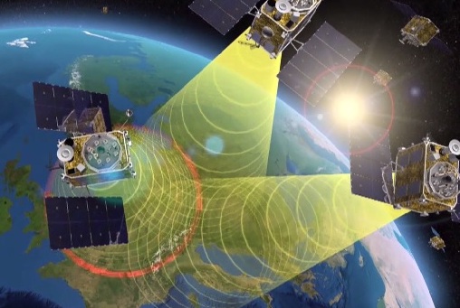
EGNOS is Europe’s first venture into satellite navigation. EGNOS broadcasts augmented information through a trio of geostationary satellites linked to a network of monitoring ground stations, to sharpen the accuracy and reliability of GPS signals across the continent. (artist’s concept: ESA)
News from the European Space Agency
The next decade’s aircraft pilots will be able to rely on enhanced, reliable satellite navigation signals on a seamless basis across much of the world, thanks to decisions made at the latest gathering of worldwide satnav augmentation system providers and experts.
The U.S. Wide Area Augmentation System (WAAS) and European Geostationary Navigation Overlay Service (EGNOS) are leading examples of satellite-based augmentation systems (SBAS) that apply additional ground stations and satellite transponders to sharpen the accuracy and reliability of existing satnav services across given geographical regions.
These performance enhancements permit satnav to be employed for safety-of-life services, especially aviation. Such systems are based on the U.S. GPS for now, but plans are being laid to move to a multi-constellation design employing Europe’s Galileo, China’s Beidou and Russia’s GLONASS satnav systems beyond 2020.
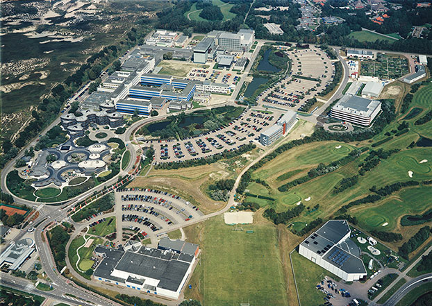
The 28th Satellite-based Augmentation Systems Interoperability Working Group (IWG), planning standardization of SBAS systems to come, was hosted at ESA’s ESTEC technical centre at Noordwijk, the Netherlands, on April 1-3.
The ESTEC facility in Noordwijk, The Netherlands. (Photo: ESA)
All participants unanimously endorsed the “message definition” for a new secondary SBAS channel — to be known as L5, along with the current L1 — for the planned second-generation SBAS systems, which will utilize dual-frequency multi-constellation signals.
Using dual frequencies greatly increases the accuracy of navigation systems, by allowing interference from the ionosphere — an electrically active outer layer of Earth’s atmosphere — to be largely subtracted from the final result.
“This definition is presented in what is called the Dual Frequency Multi-Constellation Definition document,” explained Didier Flament, representing ESA. “It represents the outcome of a four-year activity, which started at IWG 19 in Japan, back in 2010, coordinated between all IWG members under the technical leadership of ESA and French space agency CNES on the European side, and the Federal Aviation Authority (FAA) and Stanford University on the U.S. side.
“The formal IWG review loop for the document took six months to conclude, with this IWG 28 then allowing endorsements to be gathered by SBAS project managers, culminating in formal signatures to the document,” Flament said.
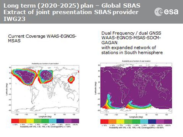
SBAS coverage for 2020: Comparing current worldwide SBAS coverage — based on WAAS, EGNOS and MSAS — to the situation envisaged for 2020–25: near-global coverage based on WAAS, EGNOS, MAAS, SDCM and GAGAN, with an expanded network of stations in the southern hemisphere, all based on a common dual-frequency/dual satnav standard being finalized by the SBAS Interoperability Working Group. (Image: ESA)
IWG members now intend to have this document accepted by the official international SBAS standardization bodies: the International Civil Aviation Organisation, the U.S. Radio Technical Commission for Aeronautics (RTCA) and the European Organisation for Civil Aviation Equipment.
“This next step is very important,” added Didier. “Not only for the coming 2016-22 implementation of the European EGNOS v3 but for implementation of other second generation SBAS in other regions of the world.”
The meeting also reported on the state of development of the other global SBAS systems. Along with the four operational systems — the U.S. WAAS, European EGNOS, Japan’s Multi-functional Satellite Augmentation System (MSAS) and India’s GPS-aided geo-augmented navigation or GPS and geo-augmented navigation system (GAGAN) — these comprise South Korea’s KASS, China’s Beidou SBAS, Russia’s System for Differential Corrections and Monitoring (SDCM) and the West African Agency for Aerial Navigation Safety in Africa and Madagascar (ASECNA) SBAS.
The follow-up IWG meeting will take place in October, hosted by the FAA in Washington, D.C., in conjunction with the next RTCA meeting.
Geodetics Inc. has teamed up with Silicon Valley’s Velodyne Lidar. Velodyne and Geodetics will work on a variety of initiatives to enhance each others technologies and products with the goal of offering a small-size integrated inertial navigation and LiDAR-based mobile mapping payload for UAVs and other autonomous platforms.
Payloads will include Velodyne’s HDL-64E, HDL-32E and VLP-16 real-time LiDAR systems combined with Geodetics’ Geo-iNAV inertial navigation systems.
Geodetics and Velodyne are exhibiting this week at AUVSI’s Unmanned Systems Show in Atlanta, being held May 4-7 (booth 1500J and booth 2838 respectively). See our show coverage page for more information.
Velodyne’s LiDAR sensors are the highest performance LiDAR systems on the market in their size, weight and power class. Geo-iNAV is a fully-integrated GPS-aided inertial navigation system that provides real-time, high-precision positioning and navigation for manned and unmanned air, sea and ground vehicles. It combines GPS and proprietary sensor fusion technologies to achieve centimeter-level real-time positioning and navigation for dynamic platforms.
“We’re delighted to work with Geodetics to ease the integration process for our customers,” said David Oroshnik, Technical Sales Engineer, Velodyne LiDAR. “Our decision to support Geodetics is based upon the growing demand for cost-effective, small-sized, fully-integrated mobile mapping payloads that deliver performance traditionally associated with higher-end systems.”
“Velodyne’s LiDAR systems enable Geodetics’ products to reach new markets and customers by delivering high performance in a smaller package and for a lower cost than competing devices,” said Lydia Bock, Geodetics president and CEO.
With recent advances in unmanned vehicle technologies, the GNSS ecosystem has expanded to support such mission-critical applications as mobile mapping. These applications increasingly require more accurate navigation to accomplish their mission. The Geo-iNAV family of inertial navigation products delivers this capability with features that support reliable and precise navigation with a low SWaP (size, weight and power) profile for autonomous vehicles and payloads on manned vehicles.
Geo-iNAV is offered in several configurations designed to meet a wide range of requirements. It is available in commercial as well as SAASM configurations, meeting a wide range of inertial navigation application requirements.
The next version (0.93) of the “gfzrnx” RINEX-2/3 Tool is now available. Because of user feedback, the developers have fixed bugs and have added these new features:
strict epoch interval handling via -sei command line parameter
support of the upcoming RINEX version 3.03 (BDS B1 obs. types, IRNSS support)
The software is still in a beta state, according to the GFZ IGS Analysis team. Any feedback (such as suggestions or bugs) is welcome and can be sent to [email protected].
Stani Licul, CEO of Maxena, displays some of its antennas for use in UAS (unmanned aerial systems) at Unmanned Systems 2015, held May 4-7 in Atlanta. Maxtena’s active rugged antenna is designed for L1/L2 GPS and GLONASS bands for GNSS satellite and RTK applications.
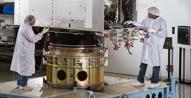
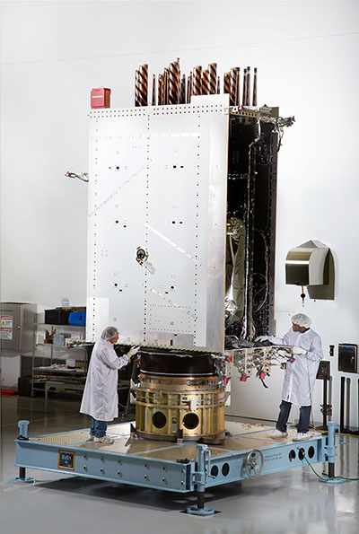
First Photo a GPS III Satellite: In April, Lockheed Martin fully integrated the U.S. Air Force’s first next-generation GPS III satellite. GPS III Space Vehicle One is now preparing for system-level testing this summer.
Using a 10-ton crane, Lockheed Martin engineers and technicians gently lowered the system module of the U.S. Air Force’s first next generation GPS III satellite into place over its propulsion core, successfully integrating the two into one space vehicle.
The April systems integration event brought together several major fully functional satellite components. The system module includes the navigation payload, which performs the primary positioning, navigation and timing mission. The functional bus contains sophisticated electronics that manage all satellite operations. The propulsion core allows the satellite to maneuver for operations on orbit.
“The final integration of the first GPS III satellite is a major milestone for the GPS III program,” said Mark Stewart, vice president of Lockheed Martin’s Navigation Systems mission area. “This summer, SV 01 will begin Thermal Vacuum testing, where it will be subjected to simulated harsh space environments. Successful completion of this testing is critical as it will help validate our design and manufacturing processes for all follow-on GPS III satellites.”
Lockheed Martin is under contract to build eight GPS III satellites at its GPS III Processing Facility near Denver, a factory specifically designed to streamline satellite production.
GPS III space vehicle one (SV 01) is the first of a new, advanced GPS satellite design block for the Air Force. GPS III will deliver three times better accuracy, provide up to eight times improved anti-jamming capabilities, and extend spacecraft life to 15 years — 25 percent longer than the satellites launching today. GPS III’s new L1C civil signal also will make it the first GPS satellite interoperable with other international global navigation satellite systems.
Planet Earth gained five new navigation satellites in late March, for four satellite systems.
GPS. The U.S. Air Force’s ninth GPS Block IIF satellite (GPS IIF-9) launched on March 25 from Cape Canaveral, Fla. The IIF-9 rode aboard a Delta IV rocket, the workhorse of the GPS fleet for successful launches. The satellite was declared operational on April 21.
“Many thought the Delta IV and GPS days were long gone, but the recent questions concerning reliable and proven launch vehicles have brought them back online, so to speak,” said GPS World Defense Editor Don Jewell. “The 20-year milestone for GPS space vehicles on orbit that occurred on April 27 translates to approximately 500 orbital years just for the IIR and IIF constellations alone. The IIAs may account for that many orbital hours as well.
“This is by far the most successful launch record ever put together by any nation or government. No other space-faring nation even comes close. The U.S. Air Force and all the players should be proud of all these records and more, plus we have one more GPS asset on orbit, providing GPS signals to the world and all they enable, courtesy of the USAF.”
Galileo. Two days later, March 27, a duo of Galileo satellites was successfully launched from Europe’s Spaceport in French Guiana. The seventh and eighth Galileo satellites rode aboard a Soyuz ST-B rocket. Both are in their planned orbits.
IRNSS. The next day, March 28, the fourth satellite (IRNSS-1D) ofthe IRNSS satellite navigation constellation was launched onboard PSLV-C27, and reached its orbital slot April 9. The Polar Satellite Launch Vehicle blasted off from the Satish Dhawan Space Center on India’s east coast, in the 28th consecutive successful PSLV mission.
BeiDou. On March 30, China launched the first of a new generation of navigation satellites, BeiDou-3 M1, for its BeiDou constellation. BeiDou-3 M1 is the first of 17 next-generation Beidou navigation satellites. It will have a new navigation signal system with inter-satellite links and other tests to verify the satellite navigation system. The new series of satellites is expected to mark an advancement in the completion of Beidou Phase III several years ahead of schedule, by as soon as 2017 rather than 2020.
GLONASS. Not making the March launch cut, GLONASS kept its hat in the orbit ring, so to speak, by issuing some far-sighted predictions. Nicholas Testoyedov, CEO of Information Satellite Systems Reshetnev, said that the first GLONASS-K2 spacecraft will be launched into orbit in 2018. “New code division (CDMA) signals will be emitted, so it will provide more accurate positioning for users.”
The GLONASS budget for 2015 will be cut by more than 5 billion rubles, a drop of more than 10 percent. GLONASS is also suffering through an embezzlement scandal, related to construction of a new ground control center.
Galileo’s worldwide ground segment as of March 2013.
Galileo Ground Upgrade
On April 9, the European Space Agency announced completion of a full-scale hardware and software migration to version V2.0 of its global Ground Mission Segment providing all Galileo navigation messages. The Ground Mission Segment was turned off Jan. 26, allowing the migration to take place over the month of February. March was taken up with detailed checking by operations and system, concluding in a final check on March 31 to validate the successful migration.
“The upgrade has provided better overall performance and availability, along with improved robustness, security and operability,” explained Martin Hollreiser, overseeing mission segment development for ESA, with Thales Alenia Space France as prime contractor. “An overall 25 percent performance improvement is confirmed.
“Three new sensor stations, Kiruna, Ascension and Azores — used to monitor the satellite navigation signals — were added to the operations chain, as well as a new uplink station in Papeete, to uplink corrections incorporated in the navigation message to the satellites for broadcast to the users.”
The Ground Mission Segment at its core is determining the exact satellite orbits and synchronizing all the satellite and terrestrial elements of that clock: the relevant control center is linked to a global network of ground stations (sensor and uplink stations). The Galileo signals currently undergo technical testing, with early services for the public projected for 2016. “A further update is foreseen for the end of this year,” Hollreiser added, although this will occur with no interruption of services.
GPS Glitch Dates from 2011
On April 15, the U.S. Air Force GPS Directorate said data analysis shows that a technical error affecting some GPS IIF satellites first appeared in 2011. The error affects the way the ground control system builds and uploads messages transmitted by the satellites, but does not affect the accuracy of GPS signals. It involves the ground-based software used to index messages. “A GPS message indexing issue was recently identified that affects a limited number of active GPS IIF satellites, but does not degrade the accuracy of the GPS signal received by users around the globe. The result is an occasional broadcast not in accordance with U.S. technical specifications. ”
This year’s European Navigation Conference in Bordeaux, France, got underway with “Good news from up there .…”
Galileo’s seventh and eighth satellites launched successfully in late March, the European Space Agency (ESA) plans four more satellites to reach orbit in 2015, and space maneuvers for Galileo 5 and 6 have been completed, with a recovery plan currently under study. ESA happily confirms that satellites 7 and 8 are in good position, under control, and behaving very well.
Fiammetta Diani, deputy head of Market Development for the European GNSS Agency (GSA), followed her keynote opener with “… some good news also from down here.”
The GSA predicts that the installed base of GNSS devices will triple by 2023, with per capita rates of 2.5 in North America, and 2.3 in Europe and Russia. Around the rest of the world, in eight years nearly every person, on average, will possess a GNSS device.
Axelle Pomies of Galileo Services, an association of industry players active in GNSS applications, stressed the need for a comprehensive, assertive industry policy to support the development of EGNOS/Galileo downstream sector, leading to growth, job creation and autonomy for Europe. She previewed the mid-May publication of a draft position paper in this regard, for wide consultation within the European downstream sector. Follow www.galileo-services.org for its first appearance.
Concluding the ENC plenary, Florence Ghiron of Topos Aquitaine, a regional council of satnav and intelligent transport companies in southwest France, focused on opportunities and risks for small-to-medium enterprises. One of her points: the long development paths of public and regulatory policy do not help SMEs grow.
The Galileo Services and Topos Aquitaine presentations receive more lengthy treatment in my online column mentioned above.
Diani and Ghiron closed with a call to return to Bordeaux in October for the Intelligent Transport Systems World Congress, themed “Towards Intelligent Mobility: Better Use of Space.” GNSS looks to take a more central role than ever in this far-reaching economic segment. Good news — for us — indeed.
DroneMetrex has captured high-quality near-infrared (NIR) mapping data with its TopoDrone-100 UAV. DroneMetrex said in a news release that this is the first time such high quality NIR imagery has been captured by a UAV.
High-quality NIR data is a tool to detect chlorophyll. Because chlorophyll is emitted by all vegetation to various degrees, experts from land and forest departments, agronomists, vignerons and pastoralists will be able to discriminate between health and vigor of vegetation and between different types of vegetation. The data collected helps determine vegetation stress, disease, pest infection, irrigation faults and nutrient variations.
“We say ‘unique high-quality mapping’ because the data are both radiometrically and geometrically unparalleled from a drone,” said Thomas Tadrowski, managing director of DroneMetrex. “From the one-flight sortie, TopoDrone-100 users are able to perform vegetation analysis mapping as well as accurate 3D contours/DTM mapping. The pixel resolution is unsurpassed. The data geometry is unsurpassed. The radiometric mapping is unsurpassed.”
DroneMetrex offers its Extended Spectrum Mapping (ESM) camera modification as an option with the TopoDrone-100. After ESM modification, the camera is supplied with three external screw-on lens filters. Simultaneously using the NIR filter and a high-accuracy L1/L2/L5/GLONASS/COMPASS (BeiDou-2) PPK direct georeferencing solution, the TopoDrone-100 captures three-band imagery, with the near-infrared band recording unparalleled radiometric quality and chlorophyll discrimination.
The high radiometric quality is achieved because DroneMetrex specialists perform the necessary camera modifications themselves, and have designed the external filters specifically to match the requirements of accurate, discriminative vegetation mapping, DroneMetrex said.