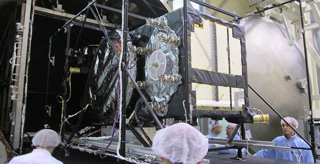
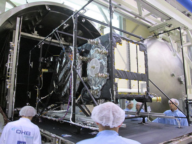
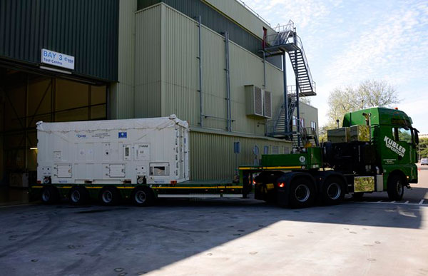
Weeks of testing simulated the airlessness and temperature extremes of orbital space, taking place at the ESTEC Test Centre in Noordwijk, the Netherlands during May 2015. (Photo: ESA)
News by the European Space Agency
Europe’s latest Galileo was unboxed at ESA’s technical centre in the Netherlands in May, bringing the total number of satellites at the site to four.
ESTEC in Noordwijk is the largest satellite test facility in Europe, with all the equipment needed to simulate every aspect of the launch and space environment under a single roof. It is an essential stop on the way to space for Europe’s Galileo satellites, built by OHB in Bremen, Germany, with navigation payloads from Surrey Satellite Technology Ltd. in Guildford, UK.
The 12th Galileo arrived by lorry from Bremen on May 13, in a custom-built environmentally controlled container. The satellite will begin with a thermal vacuum test in a 4.5-meter-diameter stainless steel chamber, subjected to about five weeks of hard vacuum and the temperature extremes of space.
Galileo-11 recently completed the same trial before moving on to final system testing, including a compatibility run with the ground network.
Meanwhile, the ninth and tenth satellites are in storage at ESTEC, having passed their own checks. They will be flown to Europe’s Spaceport in French Guiana in late July for launch by Soyuz in September, which will bring the total in orbit into double figures.
The 12th Galileo satellite, FOC FM-08, arrived at the ESTEC Test Centre on May 13. It was transported by lorry from Bremen in a protective air-conditioned container.
The first four Galileos, launched in 2011 and 2012, were in-orbit validation satellites, built by prime contractor Airbus Defence & Space. They confirmed that the overall system worked as planned, while also serving as the foundation of the full constellation to follow.
The follow-up Full Operational Capability satellites are now being launched regularly to increase the size of the constellation to the point where early Galileo services can begin next year.
European Partners. Galileo is a collaboration between ESA and the European Commission (EC). The validation phase was co-funded by ESA and the EC, while the full operational phase is funded by the EC. Under a delegation agreement, ESA acts as design and procurement agent on behalf of the commission.
The Multi Micro Hornet by OriginGPS was designed small with wearables in mind.
OriginGPS has launched the Multi Micro Hornet, a tiny fully integrated multiple constellation antenna module. The innovative architecture packs functionality and high-quality components in a small space to improve wearables’ fashion and function, the company said.
“A recent study by the European Global Navigation Satellite Systems Agency (GSA) showed that multi-constellation is becoming a standard feature in today’s user equipment,” said Gal Jacobi, CEO of OriginGPS. “Developers of wearables need modules with these features in the smallest size possible to be competitive in a market the GSA predicts will reach 14 million by 2023.”
The Multi Micro Hornet is designed for devices that require a small form factor, low power consumption, and high sensitivity. In keeping with the company’s “Mini + Mighty” corporate mantra, OriginGPS has reduced the total volume in size by over 68 percent of other GNSS antenna modules without sacrificing performance, the company claims.
The Multi Micro Hornet by OriginGPS.
The Multi Micro Hornet has features that will improve the navigation experience of wearables and other Internet of Things devices, including:
Small size, high performance: Despite its miniature outline of 10 x 10 mm and height of 5.9 mm, the Multi Micro Hornet module offers superior sensitivity and outstanding performance, achieving rapid Time To First Fix (TTFF) of less than one second, accuracy within as little as one meter, and sensitivity at -165 dBm by tracking both GPS and GLONASS constellations simultaneously.
High sensitivity and noise immunity: The Multi Micro Hornet continues to leverage OriginGPS’ patented and proprietary Noise Free Zone NFZ technology to ensure high sensitivity and noise immunity even under marginal signal conditions.
Reduced power consumption without compromising connectivity: It detects changes in context, temperature, and satellite signals to achieve a state of near continuous availability. By opportunistically updating its internal fine time, frequency and satellite ephemeris data, the Multi Micro Hornet is able to stay connected while consuming mere microwatts of battery power.
An intelligent design that shortens time to market: The Hornet family of GPS / GNSS antenna modules integrates a GNSS receiver and patch antenna in a single module. As a cornerstone of the OriginGPS portfolio, the Multi Micro Hornet’s pin-to-pin compatibility with the Micro and Nano Hornet modules ensures a seamless migration from GPS to GNSS and gives developers the ability to create new product offerings in the shortest time to market while minimizing costly design risks. Developers can connect it to a power source on a single layer PCB and be off and running.
Additionally, the Multi Micro Hornet module combines OriginGPS’ proprietary low-profile GPS+GLONASS antenna with a dual-stage LNA, RF LDO, SAW filter, TCXO, RTC crystal and RF shield with SiRFstarV GNSS system on chip.
The conference will be open with keynote speeches by Chris Cappelli (Esri Inc.) on “The Age of the Location Platform: How Mapping and GIS are Transforming the Work Environment” and Prof. Georg Gartner (TU Wien, Vienna University of Applied Sciences), president of the International Cartographic Association, on “The Future of the Map – the Map of the Future.”
“The agenda for the INTERGEO conference in Stuttgart is packed with exciting topics that are the focus of ongoing political debate on the digital world and will play a key role in shaping the way we work in future,” reads a statement by INTERGEO. “With keynote speeches and plenary talks delivered in English and simultaneous interpreting provided for one strand of the conference on the second day, it is clear that INTERGEO is also becoming increasingly significant on an international scale.”
The major topic of discussion at 2014’s INTERGEO remains a key part of the conference this year — INSPIRE examines geo-issues from a European perspective, providing practical examples and focusing on further development of the European directive. Other central themes include geodata as a basis for construction management and land development, a major concern for future development at regional and local level, as well as issues relating to property markets and valuation. These subjects are all crucial when it comes to discussing the “smart cities” and “smart villages” of the future, according to INTERGEO.
Another highlight of INTERGEO in Stuttgart this year will be the panel discussion on the second day on “Geospatial Information – A Key Element for Emerging Markets.” The high-profile panel of speakers include Bengt Kjellson (UN-GGIM Europe), Ola Rollen (Hexagon), Steve Berglund (Trimble) and Chris Cappelli (Esri Inc.).
A further key topic at the conference that is set to have a profound effect on the working world is geoinformation and mobility. DDGI and DVW will be addressing this together and discussing practical examples in two event strands.
The contributions on big data will focus on the rapid development of data capture, processing and presentation as well as the direct integration of data into business processes. Geoinformation as an element of networked processes is a subject of major international significance, as evidenced by the conference’s high-profile speakers. “In terms of digitization, the conference will be key to paving the path to Geospatial 4.0 and the networking of digital geodata,” said Prof. Karl-Friedrich Thöne, president of the event’s host, DVW, adding, “INTERGEO is the ideal forum for creating processes that could eventually benefit the entire value-added chain.”
As important as data may be in the digital world, it is also crucial to have the right visualization concepts in place. This will be demonstrated through presentations on the German Cartographers’ Day, which will form part of INTERGEO this year.
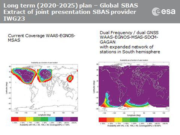
Current coverage (left) of WAAS, EGNOS and MSAS; long-term 2020–2025 (right) plan for dual-frequency, dual-GNSS WAAS-EGNOS-MSAS-SDCM-GAGAN.
SBAS Agree to Common Message
Aircraft navigation and safety will benefit from enhanced, reliable satellite navigation signals on a seamless basis across much of the world in the 2020–2025 timeframe. The 28th Satellite-based Augmentation Systems Interoperability Working Group (IWG) came to agreement on standardization of satellite-based augmentation systems (SBAS) in a meeting hosted by the European Space Agency in early April. The group planned a shift from reliance exclusively on GPS to a multi-constellation design employing Galileo, BeiDou and GLONASS after 2020.
The agreement centers around a message definition for a new secondary SBAS channel — to be known as L5, along with the current L1 — for second-generation SBAS systems, which will utilize dual-frequency multi-constellation signals, greatly increasing the accuracy of navigation systems available to airliners by largely eliminating ionospheric errors. Plans also call for an expanded network of stations in the Southern Hemisphere. The IWG document must now be accepted by the official international SBAS standardization bodies: the International Civil Aviation Organisation, the U.S. Radio Technical Commission for Aeronautics (RTCA) and the European Organisation for Civil Aviation Equipment.
The meeting also reported on the state of development of the other global SBAS systems. Along with the four operational systems — the U.S. WAAS, European EGNOS, Japan’s Multi-functional Satellite Augmentation System (MSAS) and India’s GAGAN (GPS and geo-augmented navigation system) — these comprise South Korea’s KASS, China’s Beidou SBAS, Russia’s System for Differential Corrections and Monitoring (SDCM) and the West African Agency for Aerial Navigation Safety in Africa and Madagascar (ASECNA) SBAS.
UAV Integration into Airspace
The Federal Aviation Administration (FAA) announced two new initiatives related to unmanned aircraft systems (UAS) at the Association for Unmanned Vehicle Systems International (AUVSI) Unmanned Systems 2015 conference in Atlanta, Ga., in early May.
FAA Administrator Michael Huertatold a large gathering of national journalists, “The unmanned aircraft industry is changing faster than any segment in the aircraft industry. A new project to harness that energy, the Pathfinder program, is partnering with three leading U.S. companies to expand unmanned aircraft operations in the United States.” The FAA is working with industry partners on three focus areas:
CNN will research visual line of sight (LOS) operations for newsgathering in urban areas. CNN will continue working with Georgia Tech University to improve newsgathering for all organizations.
PrecisionHawk will investigate agricultural operations for rural areas, flying outside LOS.
BNSF Railway, second-largest freight railroad network in North America, will undertake inspection of rail infrastructure, also beyond visual LOS.
Huerta said that the partners, collectively, “are trying to push the envelope, what can we accommodate safely and what can we learn from that.We’ll test a little, learn a little, then test some more. How do we see a staged implementation? To integrate unmanned aircraft, but to do it safely. We’re trying to push the edges of what we can allow, working with partners who have specific uses and resources.”
As to a timeframe to reach new UAV regulations, he replied, “I can’t comment a lot on the rule itself, but it’s fair to say that in the rulemaking comment process [closed on April 24], we received more than 4,500 comments. It’s too early to say how those comments will shape the final rulemaking.
“Assessment will be done in the coming months, perhaps by the end of the year, but that’s an aggressive timetable. That’s not accomplished in six months, nor should it take a million years.”
New Airbus EGNOS-Capable
The new Airbus A350 airliner, now entering service, comes fitted with EGNOS. The EGNOS system is being adopted by European airports to enable satellite-guided landing approaches. The A350’s Satellite Landing System allows pilots to perform precision-landing approaches guided by EGNOS or its U.S. equivalent, WAAS. The capability offers vertical landing guidance down to a minimum of 60 miles.
New Galileo Satellite on the Air
Monitoring by researchers at the German Aerospace Center (Deutsches Zentrum für Luft- und Raumfahrt, or DLR) indicates that one of the Galileo full-operational-capability (FOC) satellites launched on March 27 has begun transmitting standard L-band signals using pseudorandom-noise-code identifier 22.
The first E1 and E5 signals from GSAT0204, also known as FOC-FM4 and Galileo 8 and as NORAD object 40545, were received at an International GNSS Service Multi-GNSS Experiment tracking station in Windhoek, Namibia, at about 11:32 UTC May 21. The satellite’s signals were subsequently tracked by a station in Wettzell, Germany, and then by others.
The signals will be set unhealthy for use until satellite commissioning is completed.
News item courtesy of CANSPACE Listserv.
Euroship Gets eLoran as Backup
Container ship in port.
Ship management company EuroShip Services Ltd. has installed eLoran as a backup to GPS to ensure the safety of its vessels operating off the coast of the United Kingdom.
The trial installation may lead to implementation across the full fleet of16 vessels managed by Euroship, working routes in Northern Europe. The land-based radio navigation system is intended to seamlessly take over in the event of a GPS outage. EuroShip plans to simulate GPS outages to test eLoran provision of position, navigation and timing data automatically.
New GPS III RFP
The U.S. Air Force (USAF) has released a draft Request for Proposal for GPS III Launch Services, encompassing launch vehicle production, mission integration and launch operations.USAF reintroduces competition into the Evolved Expendable Launch Vehicle (EELV) program after more than a decade.
GPS III is the first of nine launches the Air Force intends to competebetween now and 2017, followed by 25 more from 2018 to 2022.
At the European Navigation Conference held in Bordeaux, France, April 7–10, a keynote session and ensuing panel discussion addressed the issue of “GNSS Resilience for Terrestrial and Naval Applications.” During the discussion, two questions from the floor drew these responses from panelist Jan Wendel of Airbus Defence & Space GmbH, a leading European aerospace company.
Do you believe that receiver manufacturers will be able to deliver resilient receivers in the future?
JW: In order to achieve resilience, regulatory measures can only provide a mid- to long-term solution. Therefore, resilience needs to be addressed at the receiver level as well.
Considering spoofing, I am not aware of any confirmed spoofing incident. Iran has been claiming to have spoofed a CIA drone, which became for me at least theoretically feasible when I heard the rumor that this drone was equipped with a GPS C/A code receiver. Also, there has been a wrongly configured repeater at the Hannover airport. Nevertheless, spoofing to me does not seem to be a current threat.
However, jamming is clearly a reality nowadays. In my opinion, we should first decide which level of resilience we actually want to achieve for which type of user receiver. If the simple receivers like in smartphones become more and more robust against jamming, the simple jammers available on the Internet will react with an increasing jamming power. This will leave less margin for the receivers used in more critical applications, which we really would like to see functioning permanently.
Therefore, resilience for low-end receivers might not be a good idea; maybe it would be better to see them fail in some scenarios.
Another aspect in the discussion we have had so far is the spreading-code encryption for authentication purposes. Actually, I see spreading-code encryption more as a means to restrict the access of a GNSS signal to authorized users and as an anti-spoofing measure, but not primarily as a means for authentication. Here, we must be aware that the access is not necessarily as restricted as we would like to think.
With directive antennas, blind demodulation techniques and a communication link, it is possible with a slight delay to achieve a position, velocity and time solution at a rover, without being an authorized user of the respective service.
We must understand resilience also in a more global sense, that such a possibility must not be detrimental to the applications assuming a restricted access to specific GNSS services.
Do standards help?
JW: In general, standards are a good thing, as they help in the construction of complex systems by assuring interface compatibility and also minimum performances. However, care needs to be taken when the standards are defined. For example, in the NMEA 0183 protocol, essential information is missing that is required for integration of a GNSS receiver with an inertial navigation system, for example, vertical velocity, full variance-covariance matrices of the receiver’s position and velocity, or raw data like pseudorange, delta ranges and ephemeris to name a few. Clearly, the NMEA protocol was not designed for GNSS/INS integration, and for its intended use the NMEA protocol fits perfectly.
However, for many applications, it is not usable. Being a de-facto standard offered by most receivers, I think it would be beneficial if this protocol would follow more a general-purpose spirit, like most of the proprietary protocols of the different receiver manufacturers do. So with the NMEA protocol lacking relevant information, we are in a situation where for many applications either the receiver manufacturers’ proprietary protocols have to be used — given these protocols offer the required information — or the receiver cannot be used at all. For me, this is an example where a standard is not of great help, also because the process of developing such a standard towards an extended scope takes considerable time, if possible at all.
Jan Wendel is a system engineer at Airbus DS GmbH in Munich, Germany, where he is involved in activities related to satellite navigation, including tracking, integrity and sensor integration algorithms. He received the Dr.-Ing. degree from the University of Karlsruhe, where he is also a private lecturer.
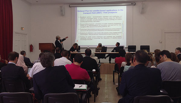
MEDUSA sponsored a Think Tank May 19 in Tunis focused on EGNOS in Intelligent Transport Systems (ITS).
Delegates from 10 countries met in Tunis May 19 for an “All-day-long Think Tank” organized by MEDUSA. The sixty participants represented Algeria, Belgium, Czech Republic, Egypt, Jordan, France, Italy, Morocco, Tunisia and Slovak Republic.
Focused on the Intelligent Transport Systems (ITS) market, the event addressed the advantages of satellite navigation, and particularly of EGNOS and Galileo. ITS concerns the integration of information and communication technologies to create new applications and services for transport and mobility. ITS applies to all transport modes and is oriented to both passenger and freight transport. Satellite navigation plays an important role in ITS.
The MEDUSA Think Tank opened with a keynote speech by Ammar Habib of the Ministry of Transport of Tunisia, who reaffirmed the country’s interest in the development of ITS and in the cooperation with Europe in relation to the exploitation of the services offered by the European GNSS in the various transport domains.
The Euromed and European panelists gave a wide overview of existing and emerging applications in their countries, such as tracking and tracing of dangerous goods transportation, tracking special regulated fleets, emergency call, road tolling, urban traffic management, control of service fleets, and freight transit monitoring. They presented the existing technologies and value-added services that can be delivered through EGNOS today, and services that will become more robust thanks to Galileo in the future. It was recognized that the European GNSS, EGNOS and Galileo, can provide benefits to more than European countries and that, though primarily conceived for the aviation needs, EGNOS has interesting perspectives of utilization in ITS, and particularly in those applications requiring accurate and reliable positioning.
The participants from different sectors (policy makers, users, technology and commercial players, experts) shared their experiences and lessons learned. They also had the opportunity for networking, establishing relationships, and strengthening cooperation on GNSS and ITS.
Organized in combination with the Elgazala Innovation Days 2015, an international exhibition on information and communication technologies, the Think Tank is one of the technical assistance actions undertaken by MEDUSA and in the frame of the program of GEMCO (Galileo EuroMed Cooperation Office), the regional cooperation structure in Tunis set up and operated by MEDUSA.
About MEDUSA — MEDiterranean follow-Up for EGNOS Adoption
Coordinated by Telespazio, the MEDUSA project belongs to the Euromed GNSS program, part of the Euromed Transport framework. MEDUSA aids the Euromed countries in the operational introduction and the exploitation of the European GNSS (EGNOS/Galileo) in various applications, mainly in the transport sectors. MEDUSA runs a program of technical assistance actions, aimed at capacity building, development of enablers and regional cooperation on EGNOS/Galileo.
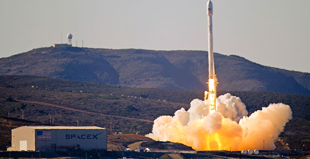
Team Vandenberg launches its first SpaceX launch from Space Launch Complex-4 Sept. 29, 2013. 30th Space Wing’s 1st Air and Space Test Squadron was the lead for all launch site certification activities at Vandenberg for SpaceX as an EELV New Entrant. The squadron evaluated SpaceX’s flight and ground systems, processes and procedures for the upgraded Falcon-9 rocket. (U.S. Air Force photo/Airman Yvonne Morales)
The U.S. Air Force has certified SpaceX’s Falcon 9 rocket to launch military satellites, clearing the way for SpaceX to bid on launches of GPS III satellites. The Air Force announced the decision May 26, which completed a nearly two-year process and establishes a competitor to United Launch Alliance.
SpaceX, based in Hawthorne, Calif., is now eligible for award of qualified national security space launch missions as one of two currently certified launch providers. The first upcoming opportunity for SpaceX to compete to provide launch services is projected to be in June when the Air Force releases a Request for Proposal for GPS III launch services.
“This is a very important milestone for the Air Force and the Department of Defense,” said Secretary of the Air Force Deborah Lee James. “SpaceX’s emergence as a viable commercial launch provider provides the opportunity to compete launch services for the first time in almost a decade. Ultimately, leveraging of the commercial space market drives down cost to the American taxpayer and improves our military’s resiliency.”
This milestone is the culmination of a two-year effort on the part of the Air Force and SpaceX to execute the certification process and reintroduce competition into the Evolved Expendable Launch Vehicle (EELV) program. The Air Force invested more than $60 million and 150 people in the certification effort which encompassed 125 certification criteria, including more than 2,800 discrete tasks, three certification flight demonstrations, verifying 160 payload interface requirements, 21 major subsystem reviews and 700 audits in order to establish the technical baseline from which the Air Force will make future flight worthiness determinations for launch.
“The SpaceX and SMC teams have worked hard to achieve certification, said Lieutenant General Samuel Greaves, commander of the Air Force Space and Missile Systems Center. “And we’re also maintaining our spaceflight worthiness process supporting the National Security Space missions. Our intent is to promote the viability of multiple EELV-class launch providers as soon as feasible.”
“This is an important step toward bringing competition to National Security Space launch. We thank the Air Force for its confidence in us and look forward to serving it well,” said Elon Musk, SpaceX CEO and lead designer.
The certification process provides a path for launch-service providers to demonstrate the capability to design, produce, qualify and deliver a new launch system and provide the mission assurance support required to deliver national security space satellites to orbit. This gives the Air Force confidence that the national security satellites being delivered to orbit will safely achieve the intended orbits with full mission capability.
The SMC, located at Los Angeles Air Force Base, Calif., is the U.S. Air Force’s center for acquiring and developing military space systems. Its portfolio includes GPS, military satellite communications, defense meteorological satellites, space launch and range systems, satellite control networks, space based infrared systems and space situational awareness capabilities.
It is heartening to see a burgeoning constellation and its operators move on from doubt to certainty, as Galileo prepares for fuller operational capability and the expectations that scope elicits.
To pick up the thread from last month’s column covering keynote speeches at the European Navigation Conference: plenaries subsequent to the opening session focused respectively on “GNSS for Aeronautical Applications: from GPS to Multi-Constellation with Galileo,” and “GNSS Resilience for Terrestrial & Naval Applications.”
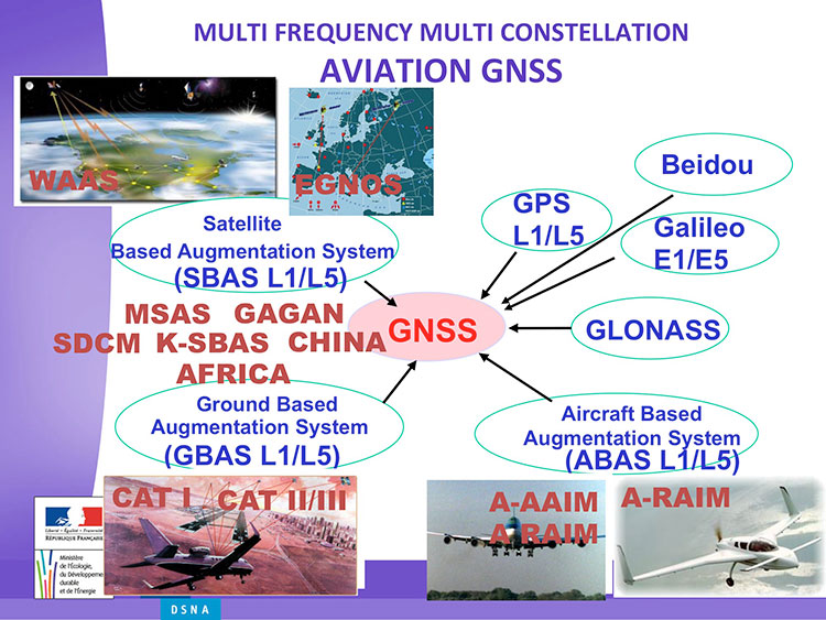
Avionics. Benoit Roturier, GNSS and Performance-Based Navigation program head for the French air traffic control agency, Direction des Services de la Navigation Aérienne (DSNA), reviewed the rather complex assembly of air navigation systems gradually coming together. Not quite — or not nearly — a system of systems, as I understand it, more a conglomeration of systems.
Slide from Benoit Roturier’s presentation on behalf of the French air traffic control agency. (Courtesy of Benoit Roturier)
Multi-constellation GNSS combos, with added context from satellite-based augmentation systems (SBAS), target provision of performance-based navigation (PBN) in all phases of flight, with increased robustness and availability, as well as escalating categories of precision approach and landing. Roturier presaged the SBAS message agreement that also took place in April with his observation that “[The] most benefits are achieved with two constellations — but which ones?” As four constellations and two frequencies deliver “many, many potential navigation modes,” how can air traffic controllers limit complexity while achieving maximum benefits? At the very least, there is a need to agree on main mode and reversion modes.
He gave an overview of upgrades planned, in progress, and completed at airports around France. 141 runways are as of January 2015 equipped with PBN, with GNSS and often EGNOS approaches, compared with 260 still relying on older systems. He concluded with a summary of DSNA views, including “SBAS/EGNOS is seen as a free of charge, performing, mature and here to stay technology, supporting navigation and surveillance (ADS-B) performance requirements.”
By the way, June’s EAGER enewsletter column will cover a recent EGNOS demonstration flight and the current state of runway approaches in Europe. Subscribe here for free.
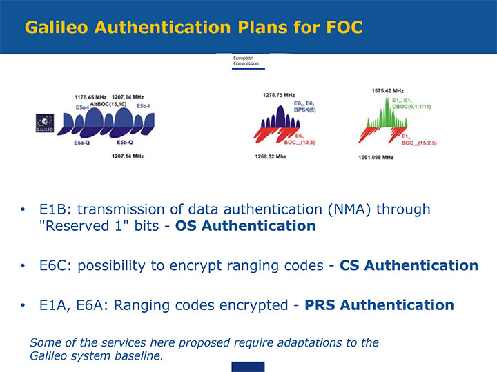
GNSS Resilience. The second plenary, on resilience, brought forth some of the most pointed commentary of the conference. Ignacio Fernández Hernández of the European Commission spoke on Galileo differentiators for resilience: its authentication plans for the Open Service, Commercial Service, and Public Regulated Service, respectively. “The proposed GNSS authentication services are 100 percent backward compatible and interoperable with other receiver-based technologies.”
Slide from presentation by Ignacio Fernández Hernández of the European Commission on Galileo differentiators for resilience. (Courtesy of the EC)
Hernandez proferred the caveat that “some of the required changes to deliver these services (particularly OS authentication) are pending on an impact analysis by industry/ESA and are not yet in the baseline. We hope however to have them in the baseline soon and we’re working hard for it.”
Matteo Paonni of the EC’s Joint Research Centre addressed spectrum management and regulatory issues, specifically the hot-button topic pseudolites. The EC is working closely with the United States and others to limit potential in-band interference risks. Outdoors, pseudolites are clearly undesirable; indoors, they offer some potential, but must be controlled.
Paonni stressed that there is a clear need to protect GNSS spectrum, and that the EC and its member states are doing their utmost to install such protections, and are also promoting GNSS radio-frequency interference detection and mitigation initiatives. Galileo’s PRS is more robust and resilient, but it is not invulnerable. GNSS vulnerabilities should be appreciated and backups put in place for critical systems; backups such as eLORAN, mini atomic clocks, GSM network, and so on.
Michel Monnerat of Thales Alenia Space focused on resilience in the road and LBS sectors. With a wide range of environments, devices and applications coming into play, “we need standardization” to specify levels of integrity and levels of performance for each different set of parameters. Thales Alenia is developing just such a set of performance requirements and references, with a first version set for release and discussion soon.
Slide presented by Michel Monnerat of Thales Alenia Space, which is working on a standardization protocol proposal, to be released soon. (Courtesy of Thales Alenia Space)
ESA BIC Bavaria, part of the European Space Agency’s Business Incubation Centre (BIC) program, is poised to expand its presence in the aerospace hotbed Bavaria with the opening of another branch office in Ottobrunn near Munich. The Bavarian state government — itself a longstanding ESA BIC partner and supporter — also hailed the program’s new partnership with Airbus Defence and Space at the Ludwig Bölkow Campus in Ottobrunn.
“The new ESA BIC Bavaria branch location in Ottobrunn will enable us to drive the creation of new start-ups based on the research endeavours pursued on-campus,” explained Ilse Aigner, Bavaria’s State Minister of Economics. “Smaller companies in particular have the ability to provide fresh, innovative ideas to Bavaria’s aerospace industry. Much of this sector’s supplier landscape also focuses on the midmarket, which makes these firms’ contributions all the more important.”
Airbus Defence and Space and the ESA BIC program expect their combined efforts to achieve another surge in the commercial use of space infrastructures and technologies.
“The aerospace hub of Ottobrunn and its newly constructed Ludwig Bölkow Campus offer an ideal setting for new companies to grow in collaboration with research and development. This new location promises to integrate Ottobrunn into the ESA BIC Bavaria’s outstanding partner program,” said Thomas Müller, member of the Executive Committee of Airbus Defence and Space and responsible for the Airbus site in Ottobrunn.
“The Ludwig Bölkow Campus is proud to figure amongst ESA’s Business Incubation Centres from now on,” added Alexander Mager, managing director of the Ludwig Bölkow Campus GmbH.
The ESA BIC program now offers start-up entrepreneurs extensive financial and technical support at 20 locations in eight countries: Belgium, France, Germany, Italy, the Netherlands, Portugal, Spain, and the UK.
“ESA’s incubation program has already helped to found 300 companies and is now supporting 100 new start-ups every year, making it the fastest-growing initiative of its kind in the space industry,” said ESA Director General Jean-Jacques Dordain, “and I am glad that the first one created was here in Bavaria with the strong support of the government and of the DLR.”
Anwendungszentrum GmbH Oberpfaffenhofen (AZO), which manages the ESA BIC Bavaria, has been responsible for 98 of these new foundations and the creation of more than 1,200 new jobs, which — along with its impressive network of partners — gives it a place of prominence among ESA’s incubation centers in Europe. Bavaria’s ESA BIC program works closely with the German Aerospace Center (DLR) and the Fraunhofer-Gesellschaft, Germany’s two largest research institutions. Further support is provided by the Wirtschaftsförderung Berchtesgadener Land (a local business-promotion association) and Bavaria’s two most financially sound savings banks, Sparkasse Nürnberg and Kreissparkasse München-Starnberg-Ebersberg.
Start-ups founded through the ESA BIC program benefit from a broad portfolio of space technologies and IP protection services, as well as from their cooperation with the various partners involved, according to ESA BIC Bavaria. “Europe’s space programs in satellite navigation (Galileo), Earth observation (Copernicus), and satellite communications also offer fantastic opportunities to established companies — and especially to those just getting their feet on the ground,” ESA BIC Bavaria said in a statement.
“Airbus Defence and Space is the first industrial aerospace company to join our incubation program,” said Thorsten Rudolph, CEO of AZO. “With its help, we’ll now be able to offer our incubatees and new companies an even wider range of support, from financing and R&D all the way to market launch.”
The 2014 Federal Radionavigation Plan, just released from the U.S. Department of Transportation, touches on funding for the Nationwide Differential GPS and the use of eLoran as a precision timing alternative.
The plan is signed by the Secretaries of Defense, Transportation and Homeland Security, and released by the DOT Office of the Assistant Secretary for Research and Technology. A PDF of the document has been posted to the NAVCEN’s website.
Nationwide Differential GPS (NDGPS). The nationwide differential GPS (NDGPS) service augments GPS by providing increased accuracy and integrity using land-based reference stations to transmit correction messages over radiobeacon frequencies. The service has been implemented through agreements among federal agencies including the Coast Guard, DOT and the Army Corps of Engineers, but a decision has not yet been made on funding beyond FY2016:
“The Department of Homeland Security, in coordination with the Department of Transportation, is analyzing the future requirements for the NDGPS to support investment decisions beyond Fiscal Year (FY) 2016. Future investment decisions might include maintaining NDGPS as currently configured, decommissioning NDGPS as currently configured, or developing alternate uses for the NDGPS infrastructure. Contributing factors to these decisions are: (1) the U.S. Coast Guard change in policy to allow aids to navigation (ATON) to be positioned with a GPS receiver using Receiver Autonomous Integrity Monitoring (RAIM), and to allow USCG navigation in all waters using the WAAS receiver; (2) limited availability of consumer grade NDGPS receivers; (3) no USCG DGPS carriage requirement on any vessel within U.S. territorial waters; (4) the Presidential Directive turning off GPS SA; (5) continuing GPS modernization; and (6) the Federal Railroad Administration’s determination that neither NDGPS, nor High Accuracy NDGPS, are requirements for the successful implementation of Positive Train Control.”
eLoran for Timing. eLoran is mentioned in the plan only briefly, in the following excerpt about precision timing alternatives:
“For precise timing applications, chip-scale atomic clocks are now available from at least one company, and others have active research and development programs in the United States and abroad. The U.S. Coast Guard has established a Cooperative Research and Development Agreement to assess a high-power wireless alternative for providing precise time using U.S. government facilities such as mothballed Loran-C sites, upgraded to eLoran capability. If successful, this effort would offer another solution suitable for integration with GPS, or use as an independent complement to GPS, that could together provide highly available and precise timing for many applications.”
JSC “Russian Space Systems” (RCC), together with ISS Reshetnev, plan to remove imported components in construction of GLONASS satellites, according to an Izvestia article.
Production of the advanced GLONASS satellite “GLONASS-K” is scheduled to begin later this year.
According JSC CEO Andrew Tyulina, the company intends to stop the use of foreign electronic components as soon as possible. The plan is to have 80 percent of the satellites’ electronic components payload be domestically produced by 2019.
The move seems to be spurred by international sanctions in response to Russia’s occupation of Ukraine. Following the occupation, the United States began to prohibit supply of electronic components to Russia, and the British company E2V failed to get permission to import equipment for the Russian space observatory Spektr-UV, Izvestia reports. Russia had difficulty securing components before then, however. In 2013, as relations with the U.S. cooled following Russia’s harboring of Edward Snowden and events in Syria, the U.S. State Department did not authorize a supply of components for the spacecraft Geo-IK-2.
The expected component supplier will be the largest designer and manufacturer of electronic components in Russia, Roselectronika, an entity that unites 112 companies, research institutes and design bureaus. The total investment in Roselectronika will exceed 210 billion rubles to 2020, including provision for modernizing industrial sites that produce electronic payloads for space.
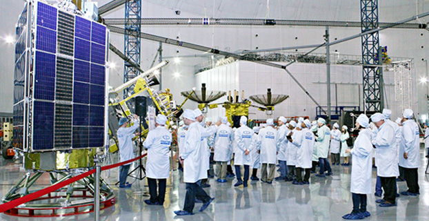
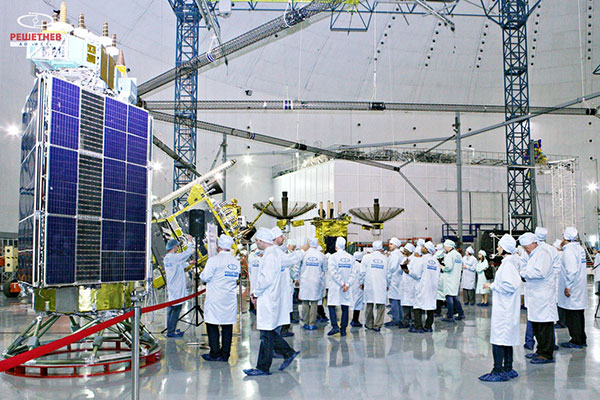
Seminar participants visit the GLONASS production facility. (Photo: Reshetnev)
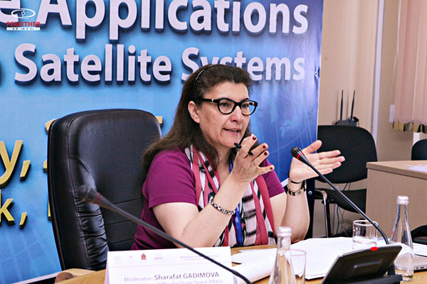
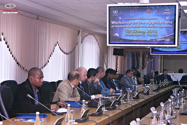
A United Nations workshop held in Krasnoyarsk, Russia, May 18-22 focused on sharing GNSS in various countries, as well as training in GNSS technologies.
The five-day workshop, organized jointly by the United Nations Office for Outer Space Affairs and the Russian Federal Space Agency (Roscosmos), sought to address the use of GNSS for various applications that can provide sustainable social and economic benefits, in particular for developing countries.
Titled “The use of global navigation satellite systems, GNSS/GLONASS,” the meeting was hosted by the Reshetnev Information Satellite Systems Joint Stock Company. This is the first time the workshop was held in Russia.
A key topic of discussion was the sharing of GNSS in different countries, according to the Reshetnev website. Particular attention was paid to training in the use of satellite navigation, with the most important outcome a proposal to create, under the auspices of the Reshetnev company, an international education center in the use of satellite navigation. The center will cooperate with the UN office in Vienna, as well as regional centers in Morocco, Nigeria, India, Brazil and China.
The seminar was held in nine sections. The sections considered topics such as the formation and development of GNSS, GNSS infrastructure, and national projects on the use of satellite navigation. Representatives from more than 20 countries in Asia, Africa, Europe, North and Latin America shared their experiences implementing GNSS services and spoke about the real and projected benefits of using these technologies for social and economic development.
During the seminar, participants visited the MFReshetnev satellite production company responsible for the space segment of GLONASS in Russia. Guests were shown current and future GLONASS-M and GLONASS-K satellites, as well as learned about the latest developments for GLONASS.
UN representative Sharafat Gadimova summarizes the workshop. (Photo: Reshetnev)Participants discuss the uses of satellite navigation. (Photo: Reshetnev)