The Russian GLONASS/GNSS Forum is conducting a survey on the future of GLONASS.
When translated, the page provides the following background:
“One of the priorities of the GLONASS system is determined to ensure its competitiveness in the global market for satellite navigation services.”Currently, public customers of the federal target program “Maintenance , development and use of GLONASS for 2012-2020 ” prepared proposals on bringing the main characteristics of the system to a level that ensures its competitiveness in the medium term ( 2020 onwards ).
“It seems appropriate that in the preparation of these proposals, the opinion of the main consumers of navigation service providers and manufacturers are taken into account.”
The survey asks the following questions (translation provided by Innovation editor Richard Langley):
What characteristics of the GLONASS system in your view are the most critical for competitiveness relative to GPS, Galileo, and Compass considering plans for their deployment and development (accuracy of the “Space Segment,” access, stability characteristics, compliance with international standards on the time scale UTC and coordinate system, others …)?
Is it important for the competitiveness of the presence of GLONASS that there be additional services such as transferring information on one of the new navigation signals to provide a highly accurate global positioning mode PPP (Precise Point Positioning) by analogy with the E6 Galileo and B6 Compass signals? What extra services could you offer for implementing in the system GLONASS for civilian users to increase its attractiveness?
Is it critical for civil GLONASS to have a complete set of new code signals (L1, L2, L3)?
Is it important in terms of competitiveness, for the GLONASS satellites, in addition to the planned new code signals in the traditional GLONASS bands (L1, L2, L3) to add another signal in the range L5? Why? If yes, for which consumers is this important?
What are the characteristics, in your opinion, that should be achieved to ensure the competitiveness of the system in 2014-2015, 2020, after 2020?
What do you see as the most effective ways to achieve the desired values of the main characteristics of the GLONASS system, including measures of state support?
Is it critical to the competitiveness of GLONASS availability to have a document of the type “Standard GLONASS civil service,” which would give the key performance characteristics of GLONASS and these characteristics would be guaranteed by the “provider” of the GLONASS system (similar to the standards issued by GPS and Compass)?
Responses are being accepted until February 14. Send responses to [email protected] with Questionnaire TTX in the subject line. Responses will be compiled and prepared for appropriate treatment to public customers of the federal target program “Maintenance, development and use of GLONASS for 2012-2020 years. “
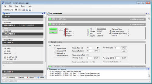
Spirent Communications, a testing navigation and positioning systems company, today announced the introduction of Spirent SimSAFE, a software solution that concurrently simulates legitimate Global Navigation Satellite System (GNSS) constellations and spoofed or hoax signals to evaluate receiver resilience and help develop counter measures. SimSAFE was developed in conjunction with Qascom, GNSS signal security and authentication experts.
As GNSS become increasingly embedded in modern infrastructure for application timing and device positioning, the opportunities for interference and spoofing attacks become greater, Spirent said. Hoax or spoofing attacks work by mimicking genuine GNSS signals, which mislead GNSS receivers. From mobile telephony to Internet banking, GNSS timing signals are used in many key systems, and yet there is no requirement on GNSS equipment to demonstrate any degree of robustness to block or even detect malicious attacks that disrupt performance. Often, affected receivers do not recognize when they are receiving fake signals and continue to operate normally, but provide false time or position information.
“GNSS signal vulnerability is becoming a significant issue,” said John Pottle, marketing director of Spirent’s Positioning Division. “SimSAFE is the first tool to help develop systems that will detect and counter spoofing attacks. This solution is unique in being able to provide a means of both emulating a spoof attack and monitoring a receiver under attack to evaluate mitigation strategies and countermeasures.”
SimSAFE is a fully controllable laboratory-based, non-radiated test solution to evaluate a receiver’s response to a wide range of spoofing attacks. The test tool generates simulated spoofing attacks that can be aligned with genuine signals from an antenna or locally generated “genuine” signals using a Spirent GNSS simulator. This allows users to simulate a wide range of sophisticated attacks, monitor the response of the receiver under attack and evaluate the effectiveness of proposed countermeasures to then improve resilience against such attacks.
screenshot: Spirent’s SimSAFE
In essence Spirent’s SimSAFE spoofing test bed does two things:
Generates simulated spoofing attacks where a Spirent RFCS is controlled to represent a hoax signal synchronized with a “genuine” signal which can be ambient GNSS or itself generated by simulation.
Monitors a GNSS receiver subject to simulated spoofing attack in order to evaluate and refine mitigation strategies or countermeasures.
The two principal applications of SimSAFE are:
The evaluation of the vulnerability of a user’s receiver when exposed to a wide range of simulated spoofing attacks.
The evaluation and refinement of spoofing mitigation techniques, signal authentication strategies or countermeasures. This work can be conducted using any receiver of the user’s choice; however, a range of receiver monitoring tools supplied with SimSAFE are enabled if the receiver supports Septentrio Binary File (SBF). A suitable Septentrio receiver is supplied in the standard configurations for this purpose.
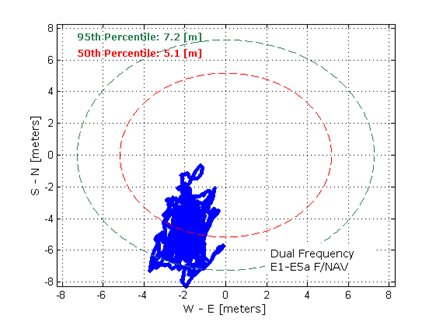
Dual-frequency Galileo positioning performance during the In-Orbit Validation phase: positioning accuracy is an average 8 m horizontal and 9 m vertical (95% of the time). Its average timing accuracy is 10 nanoseconds on average. Plot courtesy of ESA.
The in-orbit validation of Galileo has been achieved, according to the European Space Agency (ESA). Europe now has the operational nucleus of its own satellite navigation constellation in place — the world’s first civil-owned and operated satnav system.
Four is the minimum number of satellites needed to perform navigation fixes. In 2011 and 2012, the first four satellites were launched into orbit. In 2013, these satellites were combined with a growing global ground infrastructure to allow the project to undergo its crucial in-orbit validation phase: IOV.
“IOV was required to demonstrate that the future performance that we want to meet when the system is deployed is effectively reachable,” said Sylvain Loddo, ESA’s Galileo Ground Segment manager. “It was an intermediate step with a reduced part of the system to effectively give evidence that we are on track.”
Galileo Validated Video
On March 12, 2013, Galileo’s space and ground infrastructure came together for the first time to perform the historic first determination of a ground location, taking place at ESA’s Navigation Laboratory in the ESTEC technical centre, in Noordwijk, the Netherlands. From that point, generation of navigation messages enabled full testing of the entire Galileo system. A wide variety of tests followed, carried out all across Europe.
“ESA and our industrial partners had teams deployed in the field continuously for test operations,” said Marco Falcone, ESA’s Galileo System Manager. “More than 10,000 km were driven by test vehicles in the process of picking up signals, along with pedestrian and fixed receiver testing. Many terabytes of IOV data were gathered in all.”
The single most important finding from the test results? Galileo works, and it works well. The entire self-sufficient system has been shown as capable of performing positioning fixes across the planet.
Galileo’s observed dual-frequency positioning accuracy is an average of 8 meters horizontal and 9 meters vertical, 95 percent of the time. Its average timing accuracy is 10 billionths of a second. Its performance is expected to improve as more satellites are launched and ground stations come on line.
For Galileo’s search and rescue function — operating as part of the existing international Cospas–Sarsat programme — 77 percent of simulated distress locations can be pinpointed within 2 kilometers, and 95 percent within 5 kilometers. All alerts are detected and forwarded to the Mission Control Centre within a minute and a half, compared to a design requirement of 10 minutes.
“Europe has proven with IOV that in terms of performance we are at a par with the best international systems of navigation in the world,” said Didier Faivre, ESA director of Galileo and Navigation-related Activities.
In an article for The System section of the February 2013 GPS World, Peter Steigenberger, Urs Hugentobler, and Oliver Montenbruck discuss Galileo-only positioning. “Using an ionosphere-free dual-frequency linear combination of pseudorange measurements on the Galileo E1 and E5a frequencies, the position of the TUME reference station [at the Technische Universität München (TUM) in Munich, Germany] could be determined with a 3D position error of less than 1.5 meters,’” the authors said. Read more here.
Switzerland has signed a cooperation agreement to participate in the Galileo and EGNOS programs, the pillars of the EU’s Global Navigation Satellite System (GNSS). Switzerland will now fully financially participate in the programs, and will retroactively contribute €80 million for the period 2008-2013.
The agreement, signed in Brussels December 18, 2013, also covers cooperation in areas such as security, export control, standards, certification and industrial cooperation.
The Swiss government is not a member of the European Union, but does hold membership in the European Space Agency (ESA). Norway, another ESA member who is not a member of the EU, signed a similar agreement with the commission in 2010.
Swiss authorities will pay an annual Galileo fee of €27 million to the commission for access to Galileo services, but access to the Public Regulated Service (PRS) signals is still being negotiated. PRS signals will be restricted to authorized users by governments for sensitive applications that require a high level of continuity.
“I welcome Switzerland’s decision to fully step on board the European space programme,” said European Commission Vice-President Antonio Tajani. “This co-operation will not only help to provide better results for the EU’s satellite navigation services, it will also open up a series of business opportunities for small and medium sized enterprises both from Switzerland and the EU.”
Through its membership of the European Space Agency (ESA), Switzerland has contributed to Galileo’s development phase. For example, the state-of-the-art hydrogen-maser clocks used by the Galileo satellites originate from Switzerland. Such extremely accurate clocks are crucial to a number of sectors. Wireless telecommunication networks use Galileo satellites’ timing signal for network management, for time tagging and for synchronization of frequency references. Certified time stamps are also necessary for applications such as electronic banking, e-commerce, stock transactions, quality assurance systems and services.
With the signing of this agreement Switzerland will now participate in the EU satellite navigation programs and in their committees and working groups.
Studies show that Galileo will deliver around €90 billion to the EU economy over the first 20 years of operation, while from now until 2020, the EU will spend €7 billion on satellite navigation. Switzerland’s financial contribution for the period 2014-2020 will be calculated in accordance with the standard formula1 applied for the Swiss participation in the EU research Framework Programme.
The European GNSS Agency (GSA) is inviting European industries and Member State Competent Public Regulated Service (PRS) Authorities to share their views and ideas on which technologies at user segment level are important to support the adoption of the PRS. In particular, industries with potential interests and capabilities to support the development of Galileo PRS user segment technologies such as receivers, security modules, and dedicated infrastructure are encouraged to join the discussion.
PRS signals will be restricted to authorized users by governments for sensitive applications that require a high level of continuity. The PRS uses robust signals that are encrypted and resistant to jamming.
The GSA’s objective is to ensure that PRS service is affordable and secure for all interested users while also ensuring that European industry maintains its competitive edge in the global satellite navigation marketplace.
The GSA has already conducted several studies and projects aimed at identifying, developing and sustaining the necessary technology to support PRS market uptake. Additional initiatives are expected to be launched within the Horizon 2020 Framework Programme and in other programme initiatives in late 2014 and 2015.
Based on openly available information, the GSA has drafted a roadmap for developing and identifying the necessary secure technologies. This roadmap will be augmented by information gathered during the current consultations. It is expected that industry will provide additional inputs and ideas that may be
explored in the frame of Horizon 2020 and other initiatives. The GSA will use this information in planning long-term activities in support of PRS adoption, with a focus on technology preparation for a more effective market uptake.
Consultations will focus on the following topics:
Necessary steps for transforming the identified technologies into products competitive enough in terms of cost, power, dimension etc. to support the market uptake of PRS within the 2018-2020 timeframe.
Collection of information on the current European capability and capacity with the manufacturing sectors, with particular attention to nanotechnology manufacturing capabilities, and ideas of how to better use it for PRS market uptake.
Ideas of how to build, starting from the most promising technologies, the manufacturing lines capable of serving the PRS user segment need.
Main domains, elements and interfaces that will benefit from standardization, allowing for a stronger market adoption of PRS.
The deadline to receive requests is February 28. All consultations will be organized between February and April 2014. For more information and to arrange a one-on-one meeting, send an email to: [email protected].
Galileo PRS is restricted to governmental authorized users. It is intended for use with sensitive applications that require a high-level of service continuity. Authorized users include Member States, European Council, European Commission, EEAS, EU agencies and, subject to security agreements with the EU, third countries and international organizations.
BeiDou Releases Public Service Performance Document
In late December, director Ran Chengqi of China’s Satellite Navigation System Management Office announced the BeiDou Navigation Satellite System (BDS) Public Service Performance Standard. The document details the public service performance parameters of the BeiDou system, including service area, accuracy, integrity, continuity, and availability. It is a basic commitment to customers from BDS providers, but also an important basis for customers to choose, use, and evaluate the system performance.
Also released is Version 2 of the BDS Interface Control Document (ICD) for the Open Service Signal. Among other changes, it includes a description of the B2I signal on 1207.140 MHz.
The publishing of the Public Service Performance Standard, a common practice among GNSS operators, is also a prerequisite for BeiDou system involvement in international civil aviation, international maritime, 3rd Generation Mobile [phone] System, and other international standard-setting organization activities.
The document has Chinese and English versions. Because document download from the BDS government website can be difficult, Richard Langley has made them available at the University of New Brunswick website:
Analysis. John Lavrakas of Advanced Research Corporation posted the following comment to the online version of this news story:
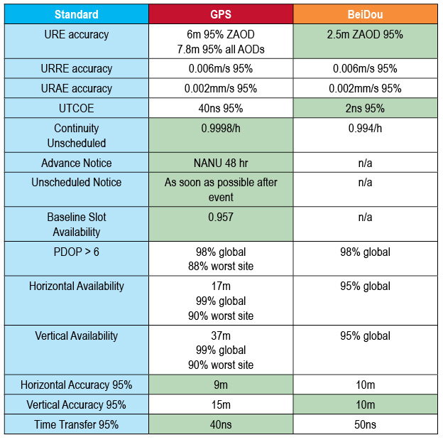
“I took a quick look at comparing the BeiDou Open Service Performance Standard with the GPS Standard Positioning Service Performance Standard and obtained mixed results.
“In some cases, the commitments from BeiDou were stronger (URE accuracy, the table to show green for the GNSS service committing to a more stringent standard over the other vertical position), and in other cases the commitments from GPS were stronger (continuity of service, advance notice of outages).
Table 1. Coded to show green for the GNSS service committing to a more stringent standard over the other. Courtesy of Advanced Research Corporation.
Galileo to Sail, Penalty-Free
Schedule Overruns Not a Problem, Avers Space Agency Director-General
Athough the European Commission (EC) sternly put in place financial penalties for late delivery and arrival on orbit of Galileo satellites, the European Space Agency (ESA) that manages the process will not suffer the consequences of a one-year delay in their launch. The EC did not sign an industrial contract with the ESA for the Galileo work, according to an announcement by ESA Director-General Jean-Jacques Dordain made the announcement in mid-January 17.
Dordain said under the agreement, the EC pays for ESA’s staff costs, while ESA acts as technical manager for the program. But the industrial contract itself to build the satellites — and specifying the penalities — was not encompassed by this agreement.
Galileo’s schedule is now firmly back on track, according to ESA,since the first OHB satellite passed thermal-vacuum testing in November, and the second satellite is in the test chamber. Signals are apparently “go” for their launch in June aboard Soyuz rocket from Guiana Space Center in South America. A second pair should launch in October, and a third in December.
Meeting an Aggressive Date. The EC committed some time ago to start initial Galileo services in 2014. Delivery on this promise has become increasingly unclear after recent testing delays. Getting new Soyuz launch dates withing this year is not a sure-fire thing, either.
The Galileo Supervisory Authority earlier announced that it had validated the four initial operating-capability (IOV) Galileo spacecraft in orbit as perform twice as well as expected in terms of signal accuracy. However, the satellites provide very limited use, about one hour per day when all are visible to the same user.
Once six satellites become visible inthe sky, sometime after the planned June launch, testing qualification of early services can begin. With eight, actual service qualification is possible but not certain. Finally, with 10 satellites — December? — early services may be able to start.
Earlier last year, EC Vice President Antonio Tajani had warned that financial penalties to those building Galileo would cover the cost overruns due to the delay in launching the system. His finger appeared to point at ESA as much as OHB AG of Germany and Surrey Satellite Technology Ltd. of Britain, who lead the industrial consortium building the satellites.
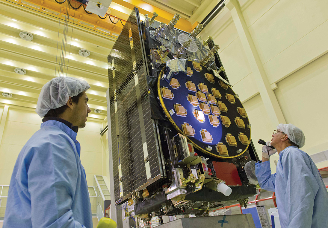
The main antenna of the second Galileo Full Operational Capability (FOC) satellite being inspected with a flashlight in advance of mass property testing at the European Space Agency’s ESTEC Test Centre in the Netherlands. Thermal-vacuum testing on the second model began in early 2014. The two FOC satellites will be launched on a Soyuz rocket from Europe’s French Guiana Spaceport in mid-2014. Whether four more can rise and begin providing initial Galileo services by the end of the year is the question of the hour.
U.S.Transport DepSec Takes Potshot at CNAV
The departing Deputy Secretary of Transportation, John Porcari, wrote a letter in the closing days of 2013 opposing the U.S. Air Force’s announced plans to begin broadcasting Civil Navigation (CNAV) message-populated L2C and L5 signals as early as April 2014. Military personnel are incensed over what they see as Porcari’s impugning, when not ignoring, the Air Force 35-year track record of broadcasting the gold standard of global navigation satellite signals — something in which Transportation has zero experience.
Porcari alludes in his December 27 letter to “non-standard engineering tools” and “non-standard operations” that he believes would come into play for early CNAV broadcast. “These have the potential to inject human error, which may result in unacceptable GPS constellation operation.”
What Porcari means by “non-standard” he does not specify, although he confesses to unease as “the ability to monitor these signals, [without which] the system will not know if the L2C and LS signals are within specification. Given these risks, DOT is concerned that the CNAV messages could provide hazardously misleading information, impacting GPS safety-of-life, protection of property, and economic security applications.” The full text of the Porcari letter is available here.
OCX Delay the Cause? Because the current GPS ground control system cannot generate CNAV, and the next-generation OCX —which can — will not be ready by April, anothercomputer will apparently develop the civil signal navigation data. However, neither the data or message is intended for actual use, nor will the FAA or any transport agency employ it. The advance project is designed to aid reciever manufaturers and developers in adpting to the new signal.
In addition to questioning Air Force 2 SOPS ability to broadcast an accurate, compliant signal containing CNAV, the letter appears to ignore — or be ignorant of — the 17 official U.S. government/military monitoring sites for GPS distributed around the world, not to mention thousands of other monitoring sites run by government agencies such as the Jet Propulsion Laboratory, the National Aeronautics and Space Administration, and the National Geospatial-Intelligence Agency, and by many universities such as Stanford, Ohio State, Cal Tech, and many other international institutions around the world. Many of these sites collaborate under the rubric of the International GNSS Service.
Finally, John Deere and Trimble Navigation both operate automated GPS signal monitoring systems that that report any anomaly in the navigation message for all GPS signals with an average two-second notification time.
“This letter is so much BS,” fumed one source who wished to remain anonymous, “coming from an agency that is in arrears in its GPS payments to the tune of more than $70 million and has no clue how to represent the global GPS user. GPS is a ubiquitous system, not just a tool for the DOT and the Federal Aviation Administration. GPS needs to implement these signals for all users and as a modernization program that was promised to be in place years ago.”
Porcari left for the private sector.
OCX Change Order to Ensure Proper M-Code Function
Raytheon Intelligence and Information Systems has been awarded a change order for work that costs up to $8.5 million on its existing contract to ensure that the new military signal, M-code, works with the GPS Operational Control System, according to an announcement from the Pentagon as reported by Space News.
Raytheon is building the ground station (OCX) for a new generation of satellites that will bring more safety and precision to GPS. The contract modification is to assure implementation of M-code capabilities across OCX Block 1 and 2. M-code is the new highly secure, anti-jam signal designed for the GPS III constellation. The current GPS ground control system lacks M-code capability.
The OCX is designed to work with the advanced GPS III positioning, navigation and timing satellites, slated to start launching in 2015, and also will be backwardly compatible with existing GPS satellites.
Raytheon won the $886.4 million prime contract to develop the OCX in February 2010. Work will be performed at Raytheon’s facility in Aurora, Colorado, and is expected to be completed by August 31, 2016.
The Air Force Space and Missile Systems Contracting Directorate, Los Angeles Air Force Base, California, is the contracting agency.
Details. Raytheon Intelligence and Information Systems, Aurora, Colorado, was awarded the unpriced change order (P00112) with a not-to-exceed of $8,595,748 on an existing contract (FA8807-10-C-0001) for M-Code Implementation on the Operational Control System. The contract modification is to assure implementation of M-Code Capabilities across OCX Block 1 and 2. Work will be performed at Aurora and is expected to be completed by August 31, 2016. Fiscal 2014 research and development funds will be obligated at definitization.
GAGAN Certified for Aviation over India
The Director General of Civil Aviation of India has certified the GPS-Aided Geo Augmented Navigation (GAGAN) system to Required Navigation Performance 0.1 Nautical Mile (RNP0.1) service level.
Aircraft equipped with satellite-based augmentation system (SBAS) receivers can now use GAGAN signals in Indian airspace for en route navigation and non-precision approaches without vertical guidance.
Mission control centers and uplink stations now operate on Indian soil. Messages carrying corrections to GPS signals are sent to satellites in geostationary orbit carrying the GAGAN payload.
The availability of the GAGAN signal over Indian airspace bridges the gap between European Union’s European Geostationary Navigation Overlay Service (EGNOS) and Japan’s Multi-functional Satellite Augmentation System (MSAS) coverage areas.
The SBAS consists of 15 Indian reference stations, three uplink stations, three mission control centers, and three GAGAN payloads broadcasting in C and L bands and with all the associated software and communication links.
GAGAN will provide augmentation service for GPS over India, the Bay of Bengal, South East Asia and the Middle East expanding up to Africa.
Car, Nav Makers Emulate NSA: Track, Store Consumer Data
U.S. Big Three automakers and some Japanese car companies track and store data from customers’ on-board navigation systems, according to a report from the U.S. Government Accountability Office. The document describes, in general fashion, practices at General Motors, Ford, Chrysler, Toyota, Honda, and Nissan, and further delves into data storage by GPS manufacturers Garmin and TomTom and nav app designers Google Maps and Telenav.
The GAO said the automakers collect data at times to assist customers with traffic updates, emergency roadside assistance, and to track stolen vehicles.None of the companies currently sell the data, according to the report, but most drivers do not know what information is being tracked and cannot opt out of the data collection programs.
The companies can “track where consumers are, which can in turn be used to steal their identity, stalk them or monitor them without their knowledge. In addition, location data can be used to infer other sensitive information about individuals such as their religious affiliation or political activities.”
The report claims the companies’ privacy policies are sometimes unclear, making it difficult for consumers to understand the potential risks of using their GPS navigation devices.
No federal law regulates GPS privacy; it is not illegal for private companies to collect, use, or sell personal information. Several proposals have been floated in Congress to protect the privacy of GPS data, but none enacted.
Exelis has successfully completed several software upgrades for the new Global Positioning System Next Generation Operational Control System, or GPS OCX. Integration and testing were recently conducted on iteration 1.5 of the OCX navigation, encryption and Mission Upload Generator, or MUG, software.
The new version of GPS software will help ground controllers better understand the satellites’ exact positioning in space. The encryption software is also designed to automatically code and decode GPS signals, facilitating the exchange of user information by securely transmitting navigation payload data between the OCX ground system and the orbiting constellation of satellites.
The MUG software is responsible for creating spacecraft payload updates to refresh the navigation data transmitted to all GPS users. This data is typically generated for each satellite multiple times a day and helps to consistently minimize user error.
“These software milestones demonstrate a clear path to improved GPS accuracy and integrity,” said Drew Trainor, OCX program manager for Exelis Geospatial Systems. “Civilian and military users will have more accurate and secure GPS signals, and these milestones bring us one step closer to GPS modernization.”
Under a February 2010 contract award from Raytheon, Exelis is providing software that will simulate the behavior of GPS signals in space. In addition, Exelis is building high-precision receivers for use in ground monitoring stations placed strategically around the world. Exelis is also providing data encryptors that help ensure secure information exchange between the ground and space segments of the system.
Once the new operational control segment is implemented, GPS will improve a variety of business and economic practices, including air traffic control, crop management, and environmental monitoring, among others. The new capabilities offered by GPS modernization will also provide military users increased accuracy, availability, anti-jam power and international interoperability.
The Lockheed Martin team developing the U.S. Air Force’s next generation Global Positioning System (GPS) recently turned on power to the bus and network communications equipment payload of the program’s second satellite designated GPS III Space Vehicle 2 (SV-02).
The successful powering on of GPS III SV-02, on December 19, 2013, at Lockheed Martin’s Denver-area GPS III Processing Facility (GPF), is a major production milestone which demonstrates the satellite’s mechanical integration, validates its interfaces, and leads the way for electrical and integrated hardware-software testing.
“The GPS III SV-02 bus power on is a significant milestone, positioning SV-02 in line with the Air Force’s first GPS III space vehicle, SV-01, in our GPF, where both satellites are progressing through sequential integration and test work stations specifically designed for efficient and affordable satellite production,” explained Mark Stewart, vice president for Lockheed Martin’s Navigation Systems mission area.
On November 11, 2013, the propulsion core module for SV-02 was delivered to the GPF from Lockheed Martin’s Space & Technology Center, in Stennis, Mississippi, where the core was manufactured. The structural backbone of the satellite, the core contains the integrated propulsion subsystem that allows the GPS III to maneuver on orbit immediately after launch, as well as to conduct repositioning maneuvers throughout its mission life.
The GPS III program will affordably replace aging GPS satellites, while improving capability to meet the evolving demands of military, commercial and civilian users, Lockheed Martin said. GPS III satellites will deliver three times better accuracy; provide up to eight times improved anti-jamming capabilities; and include enhancements which extend spacecraft life 25 percent further than the prior GPS block. The GPS III also will carry a new civil signal designed to be interoperable with other international global navigation satellite systems, enhancing civilian user connectivity.
Lockheed Martin is under contract for production of the first six GPS III satellites (SV 01-06), the first four funded under the original contract and the fifth and sixth recent fully funded by an exercised Air Force option on December 13, 2013. Lockheed Martin had previously received advanced procurement funding for long-lead components for the fifth, sixth, seventh and eighth satellites (SV 05-08).
The first GPS III satellite (SV-01) was powered on February 28, 2013. GPS III SV-01’s spacecraft bus and antenna assemblies were delivered to Lockheed Martin’s GPF this summer. SV-01 is now in the integration and test flow leading to delivery “flight-ready” to the Air Force.
The GPS III team is led by theGlobal Positioning Systems Directorateat the U.S. Air Force Space and Missile Systems Center. Lockheed Martin is the GPS III prime contractor with teammates Exelis, General Dynamics, Infinity Systems Engineering, Honeywell, ATK and other subcontractors. Air Force Space Command’s 2nd Space Operations Squadron(2SOPS), based at Schriever Air Force Base, Colo., manages and operates the GPS constellation for both civil and military users.
China’s BeiDou system claimed a user range error (URE) of 2.5 meters zero age of data (ZAOD) 95% recently. The parallel GPS specifications commit to 6 meters 95% ZAOD and 7.8 meters 95% all AODs. Does this mean that BeiDou is more accurate than GPS? Not so fast.
In late December, director Ran Chengqi of China’s Satellite Navigation System Management Office announced the BeiDou Navigation Satellite System (BDS) Public (or Open) Service Performance Standard. The document details the public service performance parameters of the BeiDou system, including service area, accuracy, integrity, continuity, and availability. It is a basic commitment to customers from BDS providers, but also an important basis for customers to choose, use, and evaluate the system performance.
A few important qualifications of BeiDou’s performance standard first:
According to the foreword of the document, “This document specifies the BDS open service performance standard at the current stage.” This is as it should be.
A paragraph on service volume, however, highlights the fact that BeiDou is as yet a regional service.
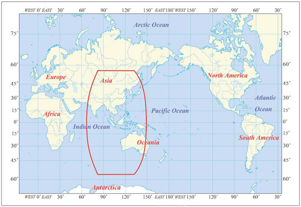
“4.4 BDS OS Service Volume
The BDS OS service volume is defined as the OS SIS coverage of the BDS satellites where both the BDS OS horizontal and vertical position accuracy are better than 10 meters (probability of 95%). At the current stage, the BDS regional service capability has been achieved, which can provide continuous OS to the area as shown in Figure 2 & Figure 3, including the most part of the region from 55°S to 55°N, 70°E to150°E.”
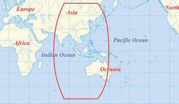
The BDS Service Area.
This means that BeiDou commits to 2.5 meter accuracy in China, as well as neighboring countries — and importantly, trading partners — in Southeast Asia plus Australia.
Does this mean that once BeiDou attains global status, it will provide 2.5 meter accuracy everywhere, on its basic single frequency, open service? Hard to tell. Much of its strength, its core strength, one might say, comes from 5 geostationary Earth orbit (GEO) satellites and 5 Inclined Geosynchronous Satellite Orbit (IGSO) satellites. The GEOs hover over the Equator more or less permanently, south of but in the general longitude of China’s sovereign national territory. The IGSOs move back and forth from the northern to the southern hemispheres in the same area.
When BeiDou achieves its planned global reach, an event scheduled for 2020, the constellation will consist of 35 satellites: 5 GEOs, stationed at longitudes so their footprints cover China, 27 medium Earth orbit (MEO) satellites encircling the globe in continuous paths as do those of GPS, and 3 IGSOs over the East and Southeast Asian regions.
Will globally available accuracy at that point match what is achievable in China? It takes a better geometric mind than mine to fathom this.
Even disregarding the geographic limit of the 2.5-meter claim, and ignoring for the moment the mathematical conundrum outlined above, there are reasons to scrutinize the BeiDou Performance Standard more closely, as John Lavrakas of Advanced Research Corporation has done. His notes, and an illuminating table, follow below after a bit more introduction and background on the general topic.
The publishing of the Public Service Performance Standard, a common practice among GNSS operators, is also a prerequisite for BeiDou system involvement in international civil aviation, international maritime, 3rd Generation Mobile [phone] System, and other international standard-setting organization activities.
The document has Chinese and English versions. Because document download from the BDS government website can be difficult, Richard Langley has made them available at the University of New Brunswick website:
John Lavrakas of Advanced Research Corporation posted the following comment to the an earlier online article announcing the Performance Standard document.
“I took a quick look at comparing the BeiDou Open Service Performance Standard with the GPS Standard Positioning Service Performance Standard and obtained mixed results.”
Table 1. Coded to show green for the GNSS service committing to a more stringent standard over the other. Courtesy of Advanced Research Corporation.
“In some cases, the commitments from BeiDou were stronger (URE accuracy, vertical position), and in other cases the commitments from GPS were stronger (continuity of service, advance notice of outages).
“The good news is that GNSS systems are documenting the service levels that users can expect. What we will need next is monitoring to verify these service levels are being met.
A final note. As the GPS stewards from the U.S. Air Force carefully and proudly remind us at each GNSS conference where they deliver a briefing, actual GPS performance has almost always bettered its specs over the last decade or two — often by a considerable margin.
And with that, I think we may all return to our various pursuits, secure in the knowledge that while the gold standard may — repeat, may — at times pass in limited special circumstances or under particular conditions, from system to system, overall GNSS Things Are Getting Better All the Time.
The regulatory announcement explains that Hexagon, Topcon Europe B.V. and Topcon Corporation have entered into a memorandum of understanding (MoU) related to Veripos, Inc. Hexagon Acquisition Ltd., an indirectly wholly owned subsidiary of Hexagon, has made an unconditional cash offer for all outstanding shares in Veripos not already owned by Hexagon Acquisition Ltd. Hexagon Acquisition Ltd. owns and has received acceptances and pre-acceptances for a total of 9,980,630 shares, representing 30.1 per cent of the outstanding shares in Veripos.
Under the MoU, Hexagon would establish a customer agreement between Topcon and Veripos, under which Topcon will act as a reseller of the satellite broadcast correction signal offered by Veripos. This “TerraStar Agreement” between Veripos and Topcon is intended to be an agreement with TerraStar GNSS Ltd., a wholly-owned subsidiary of Veripos and the contractual partner for all resellers and customers of the on-shore services. Under the TerraStar Agreement, Topcon will be entitled to offer the signal to its customers and to make its products compatible with the signal.
Also under the MoU, Hexagon and Topcon will establish a separate joint venture company on an equal partner basis for the purposes of pursuing joint efforts and cooperation in relation to the future development and direction of the services provided under the TerraStar Agreement.
GNSS receiver manufacturers who are partners with TerraStar include NovAtel, Altus Positioning Systems, and Septentrio Satellite Navigation.
The acceptance period for the unconditional cash offer expires on January 29, subject to further extensions but not beyond February 7.
It’s truly mind-boggling when I think of how early we are in the technology adoption curve — not just for geospatial technology, but technology in general. On the one hand, it’s scary to think about how much technology might penetrate and be further integrated into our lives, on the verge of threatening our privacy if we let it. On the other hand, it’s frustrating to think about how crashes, crimes and catastrophes can be avoided or minimized if today’s technology was deployed.
Crashes. There is no reason that something like the Asiana Airlines crash at the San Francisco International Airport or the Southwest Airlines Boeing 737 landing at the wrong airport in Branson, Missouri, earlier this month should have ever happened. Technology exists today that can prevent these sorts of incidents and tragedies caused by human error, and prevent some that are not caused by human error.
Simply put, if my automotive GPS receiver can steer me to the correct McDonald’s (one of many) within a city, there’s no reason a GPS receiver (with a current airport database) can’t guide a pilot to the correct airport. If I can load a CAD model into a bulldozer machine-control system and have it grade the surface material to within a few centimeters, a similar GPS system can certainly assist in landing an airliner at the San Francisco airport without hitting the sea wall.
Thinking on a broader scale, there is no reason that the vast majority of vehicle crashes should occur. That’s right, something that occurs every day and in every city in the world, causing billions of dollars of economic loss each year, should never happen. At a minimum, high-speed laser rangefinders on each side of a vehicle could monitor the distance from other vehicles/obstacles and automatically brake or warn the vehicle operator of an impending collision if preventive action is not taken. The advancement of Intelligent Transportation Systems (ITS) will change our daily lives, and that technology revolution is just beginning.
Crimes. Stolen vehicles should become nearly extinct. Just like nearly every rental car today has a GPS tracking system in it to track its location if stolen, there’s no reason that every personal and commercial vehicle should not have the same technology. In fact, every valuable (as deemed by you) possession such as your bicycle, your pets, your lawnmower, and even your kids, can be outfitted with some sort of inexpensive location technology.
How about monitoring convicted felons? Imagine the massive cost savings if prison populations could be significantly reduced because convicted felons could be “electronically incarcerated”?
Catastrophes. We can’t control Mother Nature’s power to wreak havoc with her weather phenomena, but people can be forewarned and bettered prepared to take timely action. Television has the Emergency Alert System, which is designed to enable the president of the United States to speak on television to the American population within 10 minutes. However, with services such as Netflix, Chromecast, and DVR recording devices, television viewing habits are changing. The mobile device is the new television. A tremendous amount of work still needs to be done to catch up with the rapid adoption of mobile devices.
SARSAT U.S. Rescues – 2013. Source: NOAA
The U.S. National Oceanic and Atmospheric Administration (NOAA) reported that it helped save 253 lives in 2013 using sensors on satellites to forewarn people of severe weather. According to NOAA, its satellites detected distress signals from emergency beacons carried by downed pilots, shipwrecked boaters and stranded hikers, and relayed information about their locations to first responders on the ground. It’s a powerful statement of what the combination of sensors and communications can accomplish.
“Each life we save underscores the undeniable value of NOAA satellites,” said Mary Kicza, assistant administrator for NOAA’s Satellite and Information Service.
The Common Denominator
The common technology denominator for eliminating or mitigating the effects of crashes, crimes, and catastrophes is sensors and communications. Those two technologies are the driving forces behind the next industrial revolution, and it’s going to be huge, perhaps a bigger economic impact on the world than the first industrial revolution, according to an article in the San Jose Mercury News.
The Mercury News article quotes a study published by General Electric (GE) concluding that sensors and communications (referred to as the Internet of Things in the article) could “add as much as $15 trillion to the global GDP, which it noted is roughly the size of today’s U.S. economy.” That’s a staggering number.
After I read the Mercury News article, I thought about many of the geospatial consulting projects I’m working on. The biggest challenges my clients face are related to one of three technologies: lack of inexpensive sensors, lack of communications, and lack of software to deal with the increasing volumes of data (for example, Big Data).
I’ve written about the value of sensors (GNSS, RFID, analog, etc.) quite a bit. I believe they will be the foundation of the next industrial revolution because they will provide a high level of granularity — in other words, very detailed data from which better decisions can be made. A great example is the Snapshot program that insurance company Progressive uses to dial in automobile insurance rates. Part of the Snapshot program is a device that you plug into your car’s OBD (On-Board Diagnostic) port. It monitors your driving habits for 30 days. It records how often and how hard you apply your brakes, how many miles you drive and times during the day that you drive. After 30 days, Progressive statisticians evaluate your driving habits and assign an insurance premium. If you’re a safe driver (by their definition), you’ll likely save money on your insurance premium.
According to Progressive, drivers respond to real-time feedback.
The industry publication Insurance & Technology reports that the newer version of Snapshot provides real-time feedback such as a “beep” when driver brakes too hard. Progressive General Manager Dave Pratt claims, “You do see the driving score change — we have data that says people who get that kind of feedback have fewer accidents. But I see that as real-time feedback 1.0. You want to do more, but you do not want to distract people while they’re driving either. There’s a balance to be struck.”
Progressive’s Snapshot program is a great example of using an inexpensive sensor to collect highly granular data in order to make better decisions. Think about how having access to granular data like this in your job may enhance your decision-making. If a farmer precisely knew the characteristics of the soil in all of his fields and within each field, wouldn’t he make better decisions about soil treatment and planting? If a municipal engineer precisely knew the condition of a water distribution system, wouldn’t she be able to make better decisions about maintenance and upgrade requirements?
Inexpensive sensors are only one piece of the puzzle. Without a method of real-time communication and software to process it, the value of the data suffers. Therefore, inexpensive sensors will drive the demand for both communications and data processing software.
Lastly, I’ll leave you with an image of a slide presented by Dr. James Canton, CEO at the Institute for Global Futures. The slide is part of a presentation of his entitled “Global Tech Trends 2014”. It is a concise illustration of the confluence of sensors, communications, and data.
The departing Deputy Secretary of Transportation, John Porcari, wrote a letter in the closing days of 2013 opposing the U.S. Air Force’s announced plans to begin broadcasting Civil Navigation (CNAV) message-populated L2C and L5 signals as early as April 2014. Military personnel are incensed over what they see as Porcari’s impugning, when not ignoring, the Air Force 35-year track record of broadcasting the gold standard of global navigation satellite signals — something in which Transportation has zero experience.
Porcari alludes in his December 27 letter to “non-standard engineering tools” and “non-standard operations” that he believes would come into play for early CNAV broadcast. “These have the potential to inject human error, which may result in unacceptable GPS constellation operation.”
What Porcari means by “non-standard” he does not specify, although he confesses to unease as “the ability to monitor these signals, [without which] the system will not know if the L2C and LS signals are within specification. Given these risks, DOT is concerned that the CNAV messages could provide hazardously misleading information, impacting GPS safety-of-life, protection of property, and economic security applications.” The full text of the Porcari letter is available here.
In addition to questioning Air Force 2 SOPS ability to broadcast an accurate, compliant signal containing CNAV, the letter appears to ignore — or be ignorant of — the 17 official U.S. government/military monitoring sites for GPS distributed around the world, not to mention thousands of other monitoring sites run by government agencies such as the Jet Propulsion Laboratory, the National Aeronautics and Space Administration, and the National Geospatial-Intelligence Agency, and by many universities such as Stanford, Ohio State, Cal Tech, Massachusetts Institute of Technology, and many other international institutions around the world. Many of these sites collaborate under the rubric of the International GNSS Service.
Finally, two private corporations monitor and correct all GPS signals both from space and on the ground: John Deere and Trimble Navigation. Both companies run commercial, automated GPS signal monitoring systems that that report any glitch, change, power fluctuation, or anomaly in the navigation message for all GPS signals with an average two-second notification time.
“This letter is so much BS,” fumed one source who wished to remain anonymous, “coming from an agency that is in arrears in its GPS payments to the tune of more than $70 million and has no clue how to represent the global GPS user. GPS is a ubiquitous system, not just a tool for the DOT and the Federal Aviation Administration. GPS needs to implement these signals for all users and as a modernization program that was promised to be in place years ago.”