Category: GNSS

  • The System: Compass Signal ICD this Month

    The long-awaited signal interface control document (ICD) for China’s growing GNSS will appear this month, according to representatives of the system who spoke in a “Compass: Progress, Status, and Future Outlook” workshop as part of ION GNSS and the CGSIC meetings in Portland in September.

    The ICD has been rumored to be available previously to receiver manufacturers within China, creating some disgruntlement among companies outside the country. One of the workshop panelists affirmed that GPS/Compass chips and receivers are being actively developed by many Chinese manufacturers and research institutes.

    The ICD announcement came among many valuable pieces of information presented during the pre-ION workshop, sponsored by the International Association of Chinese Professionals in Global Positioning Systems and chaired by Jade Morton, professor of electrical and computer engineering at Miami University, Ohio.

    Xiancheng Ding of the Beidou Program Office described Compass as a demo system in transition to an operating navigation system. Two more satellites will launch in 2011, making a total of five new space vehicles this year,as part of a total “simple navigational system” of nine satellites that has been built up, and what is termed a test system over the Asia-Pacific region, to be complete by the end of the year.

    Five more satellites will rise into orbit in 2012, and the system will gradually extend its coverage and improve its performance. Compass will start official regional service by the end of 2012, meeting user requirements in the Asia-Pacific region.

    ICD document v1.0 will be published in 2011, and probably in the month of October. It will be available for international download on the Compass website (as yet without an English version).

    There was some disagreement among panelists as to the final targeted number of satellites in the system: either 30, or 35. Subsequent comments indicated that much of the structure may still be under discussion. The impression given was very much of a dynamic system in formation and growing rapidly.

    In a presentation on “Preliminary Results of GPS/Compass Integrated Positioning and Navigation,” Uanxi Yang of China’s National Administration of GNSS and Applications reported integrated navigation with a Unicore UB 240 Compass/GPS receiver with up to 9-centimeter accuracy, and also mentioned a Shanghai Huace Compass/GPS receiver. Some systematic errors in Compass positioning were reported, and attributed to the sparse satellite distribution currently.

    Yang concluded with the exhortation, “Reasonable Wishes for Compass!” emphasizing the delegation’s desire to continue working diligently on, but with realistic expectations for, the new system.


    Orbit Roundup

    In other satellite news and debuts anticipated around the world:

    GPS. Back-channel reports say the cesium clock aboard SVN-63, the second IIF satellite, is not functioning properly, and that this is at least one reason why the satellite, turned over to 2SOPS control on August 19, has not been set healthy to users.

    [Correction: The September issue and env-gpsworld-integration.kinsta.cloud mistakenly reported that SVN-63 had been set operational on August 23. This is not the case. As of September 29, the satellite is still not healthy to users.]

    After repeated attempts to get the clock working, operators are ready to switch to a rubidium clock onboard, and may already have done so.

    GLONASS. The launch of GLONASS-M No. 42 from Plesetsk is scheduled for October 1. GLONASS-M Nos. 43, 44, 45 from Baikonur may occur as early as November 2. GLONASS-M No. 46 from Plesetsk is now scheduled for November 22. The launch of the next-generation GLONASS-K1 No. 12 from Plesetsk will likely slip to 2012.

    The K1 satellites will not be set healthy, but held in reserve only. The remaining M-generation vehicles launching this year will fill up the 24 almanac slots. GLONASS will have plenty of satellites held in reserve.

    Luch-5A, a Russian geostationary communications satellite that includes an SBAS payload, will launch on December 10 from Baikonur.


    FCC Calls for More Testing on LightSquared Interference

    The U.S. Federal Communications Commission (FCC)issued a Public Notice on September 14 stating that additional testing is necessary to ensure that LightSquared’s broadband network will not interfere with GPS.

    The notice states: “Following extensive comments received as a result of the technical working group process required by the International Bureau’s Order and Authorization dated January 26, 2011, the Federal Communications Commission, in consultation with NTIA, has determined that additional targeted testing is needed to ensure that any potential commercial terrestrial services offered by LightSquared will not cause harmful interference to GPS operations….

    “For more than three months, the technical working group, comprised of more than 120 participants including representatives from the Department of Defense, Department of Transportation and other federal agencies, the GPS community, various telecommunications companies and LightSquared, conducted an extensive set of tests, and LightSquared submitted a final report on June 30, 2011. The technical working group effort identified potential for harmful interference from LightSquared’s originally proposed deployment based on operation of terrestrial transmitters in both the upper and lower 10 MHz portions of its spectrum. The FCC issued a public notice on June 30, 2011, seeking comment on the report.

    “LightSquared submitted proposed mitigation techniques to remedy the interference to GPS simultaneously with the technical working group final report. Notably, LightSquared proposed to revise its planned deployment to operate terrestrial transmitters only in the lower 10 MHz of its spectrum. The results thus far from the testing using the lower 10 MHz showed significant improvement compared to tests of the upper 10 MHz, although there continue to be interference concerns, e.g., with certain types of high precision GPS receivers, including devices used in national security and aviation applications. Additional tests are therefore necessary.”


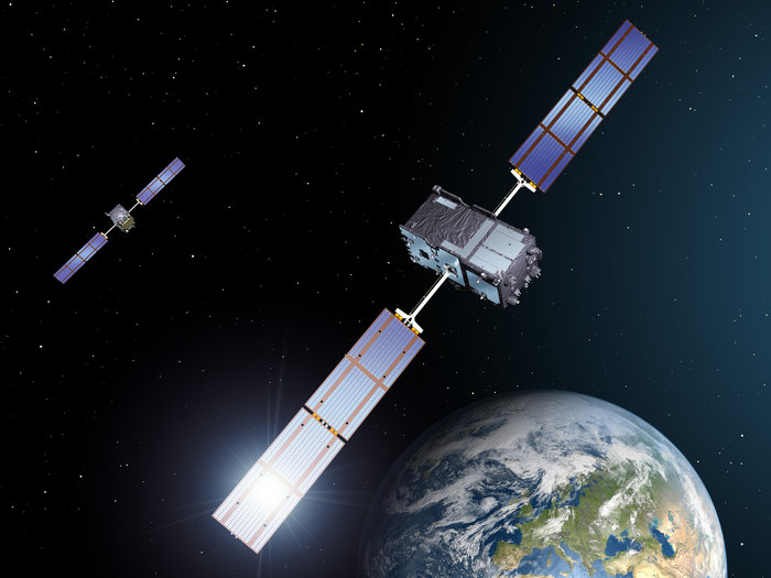
    Galileo Counts Down to October 20 for First Validation Satellites

    The first flight of a Russian rocket, Soyuz, from Europe’s spaceport in French Guiana will carry the first two satellites of Europe’s Galileo navigation system into orbit on October 20, and the European Space Agency is reporting on the preparations.

    The Soyuz launcher will be rolled out horizontally to the launch pad on October 14 and raised into its vertical launch position. The upper composite, comprising the Fregat upper stage, payload and fairing, will then be hoisted on top of Soyuz.

    The two Galileo satellites arrived from the Rome facility of Thales Alenia Space Italy, also in mid-September. In 2012, a second pair of satellites will join them in orbit, with the task of proving the design of the Galileo system in advance of the other 26 satellites. The four satellites, built by a consortium led by EADS Astrium Germany, will form the operational nucleus of the full Galileo satnav constellation. They combine reportedly the best atomic clock ever flown for navigation — accurate to one second in three million years — with a powerful transmitter to broadcast precise navigation data worldwide.

    The first Soyuz to rocket up from a port outside Baikonur in Kazakhstan or Plesetsk in Russia, the launch will take place from a new facility 13 kilometers northwest of the Ariane 5 launch site. French Guiana is much closer to the Equator than other launch possibilities, so each Galileo effort will benefit from the Earth’s spin, increasing the maximum payload into geostationary transfer orbit from 1.7 tons to 3 tons.

  • Compass ICD in October; Harmonizing GNSS

    China’s GNSS, Compass or Beidou, intends to publish its signal interface control document (ICD) in October. Representatives of the system made an unprecedented showing at ION GNSS in Portland, and referred frankly to “internal deliberations” that may be at the root of much of the public uncertainty about the system’s planned structure and timeline. Meanwhile, representatives of other navigation satellite systems also delivered updates on their status and plans. Everyone is concerned about LightSquared interference, but everyone continues to move forward.

    This month’s column is a two-parter: a guest appearance by Len Jacobson, editorial advisory board member for GPS World magazine and president of Global Systems and Marketing Inc.  Len writes on the “Harmonizing GNSS” aspect, the briefings by all systems and their efforts to achieve compatibility and interoperability. Then I’ll return with an account of the Compass panel that formed part of the CGSIC meeting immediately preceeding ION.


    len_jacobsonHarmonizing GNSS

    by Len Jacobson

    Representatives of the International Committee on GNSS (ICG) participated in briefings and a panel discussion at the ION-GNSS Conference in Portland on Thursday, Sept. 22, 2011. The ICG is a committee formed under the auspices of the United Nations Office of Outer Space Affairs. The purpose of the panel was to acquaint the audience with the activities of the ICG and to allow the global and regional satellite navigation systems providers to describe their policies and efforts with regard to interoperability and compatibility among the various GNSS and to advise how multi-GNSS services could be harmonized.

    Rick Hamilton from the U.S. Coast Guard Navigation Center organized the panel, and Jeffrey Auerbach, from the same U.S. Department of State (DOS) office as the U.S. ICG representative Dave Turner, moderated it.

    The first speaker was Sharafat Gadimova, from the ICG Executive Secretariat. She described the functions and make-up of the ICG and suggested visiting their web site www.icgsecretariat.org for further information. The next meeting of the ICG is scheduled for December 4–9, 2012 in China.

    David Turner, the deputy director of the Office of Space and Advanced Technology in the DOS, reiterated the President’s 2010 Space Policy and in particular the addition emphasizing international cooperation and more use of foreign systems by the U.S. government to enhance GPS. Turner co-chairs Working Group (WG)-A on compatibility and interoperability. He discussed a Multi-GNSS Monitoring Network using new and existing GNSS monitoring receivers and networks. He stated that the various GNSS geodetic and timing references can be found on the ICG web site.

    Dr. Sergey Revnivykh, deputy director-general, GLONASS Information and Analysis Center, stated his desire that all GNSS be considered equal. In this sense, Russian policy differs from U.S. policy, which considers GPS as the premier GNSS. Dr. Revnivykh discussed the GLONASS System of Differential Correction and Monitoring (SCDM), the Russian version of WAAS. It will augment both GLONASS and GPS. He had to leave after his presentation so was not able to participate in the ensuing panel discussion.

    Independently, we have learned from GLONASS communications that the launch of GLONASS-M No. 42 from Plesetsk is scheduled to take place on October 1 at 20:19 UTC. The launch of GLONASS-M Nos. 43, 44, 45 from Baikonur may occur as early as November 2. The launch of GLONASS-M No. 46 from Plesetsk is now scheduled for November 22. The launch  of the next-generation GLONASS-K1 No. 12 from Plesetsk will likely slip to 2012. Additionally, Luch-5A, a Russian geostationary communications satellite that includes an SBAS payload, will launch together with Amos-5, a Russian-built Israeli communications satellite, on December 10 from Baikonur.

    Next we heard a short briefing by Xavier Maufroid from the Galileo Implementation office of the European Commission in Belgium. He stressed compatibility with all services, and then interoperability. He stated that the European Union (EU) is concerned about LightSquared (LS) because LS transmissions could affect Galileo reception in the United States and also could expand to provide a similar disruption in Europe if they were to expand into that area. And if not LS, then someone else could attempt a similar broadband service over Europe with the same potential to interfere with Galileo. He later added that 7 billion euros are budgeted for Galileo between 2014 and 2021.

    From the Chinese Electronics Technology Group came Dr. Xiancheng Ding, the deputy director-general. He described Beidou (Compass) as having nine satellites with five more to be launched in 2012. This will provide regional service by the end of 2012, including over Australia and New Zealand. Beidou has a communications capability for short messaging, which is needed in rural China.

    Dr. Ding said the Beidou signal interface control document (ICD) would be released soon. Other sources indicate it to be as early as October 2011. He indicated that Beidou is fully funded for phase 2 (regional system) and will probably be funded for phase 3 (global system).

    The final briefer was Dr. Satoshi Kogure from the Japan Space Ageny. He gave a QZSS update similar to one given in other ION GNSS sessions.

    During the panel interchange and answers to questions from the audience, various combinations of signals were discussed as needing to be compatible. That is, to not interfere in same frequency band and to comply with International Telecommunications Union (ITU) regulations. Specific signal pairs mentioned in this context included: GPS L1 and L5 with Galileo; Compass and future GLONASS CDMA; the QZSS LEX with Galileo; and others.

    A WG-A workshop proposed jointly to ICG to study the potential noise impact of too many satellites. By 2020, more than 100 satellites are expected to be transmitting the myriad of GNSS signals, with up to 35 in view at any one place. This could cause mutual interference, which in turn could cause degradation in the levels of service of the various GNSS.

    Dr. Kogure described a Multiple GNSS demo campaign sponsored in part by the Japanese Space Agency consisting of tens of receivers monitoring GNSS signals over Asia and the Western Pacific. For multi-GNSS testing there is better availability in these region as there are initially more GNSS signals in view. This experiment is a prototype of a multi-GNSS monitoring network with 20 QZSS receivers by March of 2012 and 40 by a year later. China will supply Beidou receivers to Japan for the multi-GNSS Monitoring Network in cooperation with the ICG. There will be a workshop on this topic in November in Korea.

    There is still an issue between China and the EU on frequency compatibility for authorized services, but Dr. Xiancheng said a technical solution is known. Negotiations are still ongoing.

    All members of the panel were cognizant of the LS problem and are focused on providing interference detection and mitigation for their GNNS.


    Compass ICD in October

    The long-awaited signal interface control document (ICD) for China’s growing GNSS will appear this month, according to representatives of the system who spoke in a “Compass: Progress, Status, and Future Outlook” workshop as part of ION GNSS and the CGSIC meetings in Portland in September.

    The ICD has been rumored to be available previously to receiver manufacturers within China, creating some disgruntlement among companies outside the country. One of the workshop panelists affirmed that GPS/Compass chips and receivers are being actively developed by many Chinese manufacturers and research institutes.

    The ICD announcement came among many valuable pieces of information presented during the pre-ION workshop, sponsored by the International Association of Chinese Professionals in Global Positioning Systems. The workshop was chaired by Jade Morton, professor of electrical and computer engineering at Miami University, Ohio.

    Dr. Xiancheng Ding of the Beidou Program Office described Compass as a demo system in transition to an operating navigation system. Two more satellites will launch in 2011, making a total of five new space vehicles this year,as part of a total “simple navigational system” of nine satellites that has been built up, and what is termed a “test system” over the Asia-Pacific region, to be complete by the end of the year.

    Five more satellites will rise into orbit in 2012, and the system will graduallly extend its coverage and improve its performance. Compass will start official regional service by the end of 2012, meeting user requirements in the Asia-Pacific region.

    ICD document v1.0 will be published in 2011, and probably in the month of October. It will be available for international download on the Compass website, www.beidou.gov.cn (as yet without an English version), also at www.compass.gov.cn.

    There was some disagreement among panelists as to the final targeted number of satellites in the system: either 30, or 35. Subsequent comments indicated that much of the structure may still be under discussion. The impression given was very much of a dynamic system in formation and growing rapidly.

    In a presentation on “preliminary Results of GPS/Compass Integrated Positioning and Navigation,” Dr. Uanxi Yang of China’s National Administration of GNSS and Applications reported integrated navigation with a Unicore UB 240 Compass/GPS receiver, and also mentioned a Shanghai Huace Compass/GPS receiver. Some systematic errors in Compass positioning were reported, and attributed to the sparse satellite distribution currently.

    Dr. Yang concluded with the exhortation, “Reasonable Wishes for Compass!” emphasizing the desire of the delegation to continue working hard on, but with realistic expectations for, the new system.

  • Countdown to Galileo Launch via Soyuz Rocket Under Way


    Assembly of the three-stage Soyuz takes place. The Soyuz will carry the first two Galileo satellites into orbit. (Photo courtesy of ESA.)


    The first Soyuz flight from Europe’s Spaceport in French Guiana will carry the first two satellites of Europe’s Galileo navigation system into orbit on October 20, and the European Space Agency is reporting on the preparations.

    On September 12, final assembly began on the three-stage Soyuz ST-B, consisting of four first-stage boosters clustered around the core second stage, topped off by the third stage. The Launcher Flight Readiness Review in July gave the green light to begin assembling the rocket.

    The campaign began on August 16 in the assembly and testing building — known by its original "MIK" Russian acronym — with electrical and mechanical tests of the upgraded, reignitable Fregat-MT upper stage. It will carry an additional 900 kg of propellants for its double-satellite load. Fregat was then moved to the Payload Preparation Building S3B to fill its four spherical propellant tanks.

    Soyuz will be rolled out horizontally to the launch pad on October 14 and raised into its vertical launch position. A new 45-meter-tall mobile gantry was built specifically for Soyuz operations in French Guiana. It protects the satellites and the launcher from the humid tropical environment and provides access to the Soyuz at various levels for checkout activities. The upper composite, comprising the Fregat upper stage, payload and fairing, is then hoisted on top of Soyuz.

    October’s launch will be doubly historic: the first Soyuz from a spaceport outside of Baikonur in Kazakhstan or Plesetsk in Russia and the start of building Europe’s Galileo satnav constellation. The two Galileo satellites have arrived from the Rome facility of Thales Alenia Space Italy — the first on September 7, the second on September 14 — and are undergoing initial preparations.
       
    The next step will be to attach the satellites to Fregat, followed by the fairing.

    Next year, the second pair of satellites will join them in orbit, proving the design of the Galileo system in advance of the other 26 satellites. These first four satellites, built by a consortium led by EADS Astrium Germany, will form the operational nucleus of the full Galileo satnav constellation. They combine the best atomic clock ever flown for navigation — accurate to one second in three million years — with a powerful transmitter to broadcast precise navigation data worldwide, ESA reports.

  • First Galileo Satellite Arrives in French Guiana for October Launch

    The first Galileo navigation satellite has arrived in Europe’s Spaceport in French Guiana, ready to begin preparations for launch on October 20, reports the European Space Agency (ESA). Packed within a protective, air-conditioned container, the satellite known as Flight Model 2 (FM2) landed at Cayenne Rochambeau Airport aboard an Antonov aircraft at 06:45 local time on Wednesday after departing from Thales Alenia Space Italy’s Rome facility where it was built.

    A Thales and ESA team stood ready to receive FM2, having flown into French Guiana the previous week, along with all the testing and support equipment. The team loaded the satellite container on a lorry for transport to the Guiana Space Center, where it arrived at 10:00 local time and was moved into the preparation facility. It stayed there overnight for the temperature to settle before it was taken out of its container the following morning.

    The FM2 satellite is due to be launched aboard a Soyuz ST-B vehicle on October 20, together with a second Galileo satellite called the Proto-Flight Model (PFM), now being readied for its own flight to French Guiana.

    This will be the first launch of Russia’s Soyuz rocket from French Guiana, and the first Soyuz launch from a spaceport outside of Baikonur in Kazakhstan or Plesetsk in Russia. The launch will take place from a new facility 13 km northwest of the Ariane 5 launch site. French Guiana is much closer to the equator, so each launch will benefit from Earth’s spin, increasing the maximum payload into geostationary transfer orbit from 1.7 tonnes to 3 tonnes.

    The first four Galileo satellites, built by a consortium led by EADS Astrium Germany, will form the operational nucleus of the full Galileo satnav constellation.

    For more information, see the ESA website.

    Source: GPS world staff
    Galileo IOV satellite in its protective wrap.
    Source: GPS world staff
    Artist’s concept of Galileo IOVs in orbit.


  • The System: 2 SOPS Takes Over Second IIF

    The U.S. Air Force 50th Space Wing’s 2nd Space Operations Squadron took command and control of the second GPS Block IIF satellite on August 19. SVN-63 (PRN 01) was set healthy on August 23.

    The total of 12 next-generation GPS IIF satellites built by Boeing will provide improved accuracy through advanced atomic clocks, a longer design life than legacy GPS satellites, and a new signal, L5, that will benefit civil aviation and safety-of-life applications.

    The Space and Missile Systems Center’s GPS Directorate at Los Angeles Air Force Base remained in control of the satellite during a 30-day on-orbit check-out period before hand off.

    The constellation is more robust and capable than at any other time in its history, the GPS Wing said. Members of 2 SOPS operate the largest Department of Defense satellite constellation via the Master Control Station and a worldwide network of monitoring stations and ground antennas.

    Recalls IIA to Duty. For only the second time in a quarter century, Air Force officials plan to transition a decommissioned GPS satellite back to active status. 2 SOPS staff noticed in late May that the clock on the GPS IIA SVN-30 was starting to malfunction. 2 SOPS engineers and counterparts at Boeing and Aerospace Corp. developed a plan to bring SVN-35 back in to service to replace the ailing bird. The 18-year-old satellite was decommissioned from active service in 2009 to make room for the eventual deployment of the latest GPS Block IIR vehicle; however, its navigational signal continued to function properly.

    “We keep on-orbit spares for exactly this purpose,” said Lt. Col. Jennifer Grant, 2 SOPS commander. “The robustness of our current constellation and the recent completion of the Expandable 24 architecture provide us with the flexibility to perform replacements like this with minimal impact to global users.”

    OCX Hits Bump: Does Not Pass Preliminary Design Review

    The next-generation GPS Ground Control system (OCX) under the direction of prime contractor Raytheon did not pass the recently concluded initial Preliminary Design Review (PDR).

    Not passing this critical PDR inspection so early in the OCX process and in the current fiscal environment (Congress has already trimmed the modernization budget and shifted elements to the right) constitutes a blow to the GPS modernization effort. It adds to the worry concerning the OCX-GPSIIIA gap having to do with the ability to launch the Lockheed-produced GPS IIIA space vehicles (SVs) and payloads that are scheduled to be ready for launch a full 14–16 months before the OCX ground system was originally scheduled to be able to control the launch.

    That timeline undoubtedly stretches to the right with this development.

    The PDR is a formal inspection by the government acquisition agency — the Air Force’s GPS Directorate in this case — of the high-level architectural design of the OCX automated systems and the associated C2 software. The PDR, critical for any military project but especially so for the new GPS Ground C2 system, is conducted to achieve confidence that the design satisfies the functional and nonfunctional requirements and conforms with the overall enterprise architecture. Overall project status, proposed technical solutions, evolving software products, and all associated documentation are reviewed at a high level during the PDR to determine completeness and consistency with contractual standards. The PDR also serves to raise and resolve any technical and/or project-related issues, and to identify and mitigate project, technical, security, and/or business risks affecting continued detailed design and subsequent development, testing, implementation, and operations and maintenance activities.

    Typically during a PDR the government has several choices concerning the outcome. It can:

    • Approve
    • Approve conditionally
    • Withhold approval
    • Disapprove or fail the program.

    In this case, the government chose to withhold approval and not approve conditionally or formally fail until all PDR action items are reviewed.

    LightSquared Interference

    For the first time in several months, there is little in the way of concrete news to report on this topic — as of press date August 24. The Federal Communications Commission weighs its options and scrutinizes the further data that it has requested: the number and lifespan of GPS receivers that will be interfered with, and the number of terrestrial base stations LightSquared plans to deploy. Here are highlights from the “LightSquared Watch” webinar on August 18:

    GPS is arguably the most efficient use of spectrum the world has ever seen; almost a billion people benefit from the GPS signal that is available today. This use represents a massive installed base and source of innovative advantage for the United States. Most importantly, it represents a high degree of trust and confidence in the United States and its stewardship of GPS.
    — Scott Pace

    Misinformation is rampant, and the pressure for action before analysis characterized the early stages of this process. History was reinterpreted, and the facts twisted to fit desired reality. We have heard lawyers’ assertions versus engineers’ judgements — with only the latter supported by verifiable data.
    — Jules McNeff

    Launches Round the World

    China launched a fourth inclined geosynchronous orbit (IGSO) satellite in the Beidou/Compass navigation system on July 26. Its orbit is currently centered on an East longitude of about 93 degrees, some distance away from the other three IGSO satellites. Plans call for completion of a 14-satellite constellation by 2012.

    A single GLONASS-M satellite was set to be launched on August 26. Five further GLONASS launches are planned this year: a triple and a single GLONASS-M launch in October, and the second GLONASS-K1 satellite in December.

    The first two Galileo In Orbit Validation satellites are set to be launched from French Guiana on October 20, with two more following them into orbit by mid-2012.

  • The System: Technical Report on LS/GPS Interference

    Once again, developments in the news outpaced print technology’s ability to keep up in the LightSquared saga. Shortly after the July issue went to press on June 27, the TWG final report appeared on June 30. Thus you readers, who received the magazine circa July 15, held old news in your hands. Likely this will occur again.

    Chronologically in this section, from late June to mid-late July:


    Final Report of Technical Group

    The final report to the Federal Communications Commission (FCC) by the technical working group (TWG) tasked to analyze effects of powerful terrestrial L-band transmitters on the GPS signal and services finally appeared on June 30, nearly two weeks after its assigned date. LightSquared had requested an extension and used the time to write many pages of self-justification and legal argument of the company’s case. But the facts are clear: the LightSquared signal would devastate services for users of all GPS receivers tested.

    “Based on the analysis performed, LightSquared should not be permitted to use the L-Band spectrum for a densely-deployed, non-integrated terrestrial-only network. Such a network would cause unacceptable interference to GPS operations, wiping out an installed base of over 500 million units used in a wide array of public safety, aviation, industrial, and consumer applications. While mitigation techniques utilizing filters were discussed in theory, they could not be tested as part of the WG effort because filters do not exist, even in prototypes. No information considered by the WG demonstrated that any mitigation techniques — other than relocation of the proposed terrestrial network to an alternative band — would be successful.” (From the U.S. GPS Industry Council’s overview)

    The final report is not easy to find on the FCC’s labyrinthine website. Download it here.

    LightSquared COO, President Gone

    Harbinger Capital Partners, the hedge-fund firm that owns LightSquared, announced on July 6 that its chief operating officer had resigned by “mutual agreement.” Peter Jenson’s exact role in the application for a FCC conditional waiver is unknown at this time; however, it is certain to have been key.

    On June 30, the date of the TWG report, Harbinger Group Inc., a publicly traded company majority-owned by Harbinger Capital, appointed Omar Asali as acting president, replacing Harbinger founder Phil Falcone, who continues as chairman and chief executive.

    DoD, DoT Say Hands Off L-Band

    The U.S. Departments of Defense and Transportation declared their strong opposition to the LightSquared plan in a June 14 letter to the National Telecommunications and Information Administration (NTIA).

    In their official statement, “The Departments continue to support the National Broadband Plan, but cannot do so at the expense of a global, ubiquitous utility such as the Global Positioning System. The Departments encourage further assessment of any alternative spectrum and/or signal configuration plans.” See www.pnt.gov.

    The Department of Homeland Security was conspicuously absent from the signatory line, as it has been in most public goings-on. Under pointed congressional questioning about its reluctance to enter the ring, a DHS spokesperson averred that the agency had been “carrying a lot of water.”

    Javad Says End P-Code Encryption

    To solve the LightSquared versus GPS controversy, Javad Ashjaee, president and CEO of JAVAD GNSS, has appealed directly to President Obama to discontinue the encryption of P-code, the restricted military GPS signal. “This policy is not helping national security. It is hurting both precision users and the broadband project. We need more broadband, for global, fast, and inexpensive real-time kinematic (RTK) GPS.”

    IIF II Up, Up, and Away

    The U.S. Air Force successfully launched GPS IIF-2 Space Vehicle Number (SVN) 63 aboard a United Launch Alliance Delta IV Medium rocket on July 16 from Cape Canaveral Air Force Station, Florida. This is the second in the series of 12 GPS IIF satellites that Boeing has on contract with the Air Force. Boeing reported the first satellite signals from space received within four hours. On July 20, stations of the International GNSS Service tracking network reported a signal from SVN63’s L-band transmitter. Testing will ensure health of L1, L2, and L5 signals beforethe satellite is turned operational; this is expected in August.

    The satellite joins the GPS constellation of 30 operational satellites. SVN-63 will assume plane D, slot 2A, replacing SVN-24 after nearly 20 years of service.

    The IIF satellites will provide greater navigation accuracy to users through improvements in atomic clock technology and a more robust signal for commercial aviation and safety-of-life applications, through the third civil signal (L5). GPS IIFs will have a longer design life of 12 years, and will continue to deploy the modernized capabilities that began with the modernized GPS IIR satellites, including a more robust military signal.

    A Boeing statement concluded: “With safety checks completed, checkout will begin under the direction of the Air Force GPS Directorate. Checkout includes payload and system checks to verify operability with the GPS constellation of satellites, ground receivers, and the Operational Control Segment system. Boeing will officially turn over SVN-63 to the Air Force 50th Space Wing and the 2nd Space Operations Squadron this fall after the spacecraft completes on-orbit checkout.”

    GPS III Design Review Completed

    Lockheed Martin successfully completed on schedule a system design review (SDR) for the GPS IIIB satellite increment under the U.S. Air Force’s next-generation GPS III program. The company is under contract to produce the first two of a planned eight GPS IIIA satellites, with first launch projected for 2014. The contract, which features a “back to basics” acquis
    ition approach, includes a Capability Insertion Program (CIP) designed to mature technologies and perform rigorous systems engineering for future GPS III increments.

    The GPS IIIB SDR established requirements for the capability insertion planned for the follow-on GPS IIIB satellites and “validated the satellite design will meet the ever-increasing demand of more than one billion GPS users worldwide.”

    GPS IIIA will deliver signals three times more accurate than current GPS spacecraft and provide three times more power for military users, while also enhancing the spacecraft’s design life and adding a new civil signal designed to be interoperable with international global navigation satellite systems.

    GPS IIIB will provide higher power modernized signals, a fully digital navigation payload capable of generating new navigation signals after launch and a Distress Alerting Satellite System payload that relays distress signals from emergency beacons back to search and rescue operations.

    Galileo Finds LS Interference

    The head of the European agency overseeing Galileo filed an official FCC comment, expressing strong concern about the Lightsquared terrestrial signal. Analysis in Europe shows that LightSquared transmissions “have considerable potential to cause harmful interference to Galileo receivers.”

    Video. Meanwhile, the European Space Agency has a video of Galileo in-orbit validation satellite assembly and testing. The first two satellites are destined to launch together at the end of October aboard a Russian Soyuz rocket, from the European spaceport in French Guiana. They will join two experimental satellites already on orbit. See video.

  • Europe Finds LightSquared Harm to Galileo Signal

    The head of the European Commission’s Directorate General for Enterprise and Industry, the agency that oversees all operations of the Galileo program, has filed an official comment on the Federal Communications Commission’s (FCC) docket regarding the Lightsquared proposal to broadcast a powerful terrestrial signal. Heinz Zourek addresses Julius Genachowski, FCC chair, as follows:

    “I am writing to express our deep concerns about the LightSquared system that is proposed for operation in frequencies immediately below the radionavigation-satellite service (RNSS) allocation at 1559-161OMHz. This band is the core band used by global satellite navigation systems including GPS and you are no doubt aware that Europe is at the advanced planning stage for its own system, Galileo, which will be operational by 2014/15, and that will also use this RNSS allocation.

    The band immediately below 1559MHz, allocated by the Radio Regulations to the mobile-satellite service (MSS), has been used for satellite based transmissions for many years and has proved to be broadly compatible with RNSS systems above 1559MHz. The LightSquared proposal for a terrestrial network deployment in MSS spectrum would completely change the nature of radio transmissions in the band. What are now neighbour MSS transmissions at similar receive power levels to RNSS would in future be many orders of magnitude higher and with the potential to severely disrupt reception of RNSS signals.

    Analysis carried out in Europe, including by our own technical partner the European Space Agency, has shown that transmissions from LightSquared base-stations do indeed have considerable potential to cause harmful interference to Galileo receivers operating in the United States. Interference effects have been determined to occur in the range 100m to almost 1000km, depending on the type of receiver being used. This obviously presents a grave threat to the viability of providing a Galileo service covering US territory – a service which many studies have shown will not only benefit Galileo users, but those of GPS too as the two systems will be interoperable through a common signal design providing significantly improved coverage and accuracy in urban environments. The European Commission is also concerned about potential impacts to safety critical aviation applications. Europe is covered by the EGNOS system, which is equivalent and interoperable with the US WAAS, and so it is vital that EGNOS/WAAS receivers fitted to aircraft entering US airspace do not suffer degradation to the availability and reception of their navigation signals.

    The Galileo system will also contribute to the global COSPAS-SARSAT system through the MEOSAR programme and includes a dedicated space-to-Earth linle in the band 15441545MHz acting as a return channel to distress beacons, in accordance with Article 31 of the Radio Regulations. Intended for the maritime and aviation sector the possibility of disruption to this safety related application within US territory should not be ignored. Whilst recognising that the rules governing worldwide radio usage, enshrined in the ITU Constitution and the Radio Regulations, allow the USA freedom to decide on spectrum matters within its own territory, Article 4 of the Radio Regulations makes it clear that ITU Members States are expected not to cause harmful interference to systems of another country that operate in accordance with the Radio Regulations.

    We are confident that the process put in place by the FCC to deal with internal US concerns about the threat to GPS reception will reach appropriate conclusions and that these will take into account our own concerns about reception of Galileo signals. However, the receivers may not have identical characteristics and therefore we would be grateful that Galileo and EGNOS receivers will also be taken into account within the FCC’s decision making process, thus giving us sufficient assurance that users will be able to receive Galileo and WAAS signals in US territory without risk of harmful interference.

    Yours sincerely,

    Heinz Zourek

  • Exit COO and President at Harbinger, LightSquared Owner

    Harbinger Capital Partners, the hedge-fund firm that owns wireless-network company LightSquared, which recently launched a frontal assault on the GPS signal, announced on July 6 that its chief operating officer (COO) had resigned by “mutual agreement.” Peter Jenson had been responsible for all operational activities of the funds. His exact role in the application for a Federal Communications Commission (FCC) conditional waiver to broadcast a powerful L1 signal from 40,000 U.S.-based terrestrial cell towers is unknown at this time; however, it is certain to have been key.

    Harbinger and LightSquared received a recent rebuff of sorts when the FCC-appointed Technical Working Group filed its final report on June 30, calling for a move of the company’s signal out of the L-Band. Close on the heels of that report came an announcement that the U.S. Departments of Transportation and Defense asked the Administrator of the National Telecommunications and Information Administration to advise the FCC to continue to withhold authorization for LightSquared to commence commercial service per its proposed deployment of a terrestrial service within the 1525-1559 MHz bands.

    On that same June 30 date, Harbinger Group  Inc., a publicly traded company majority-owned by Harbinger Capital, appointed Omar Asali as acting president, replacing Harbinger founder Phil Falcone, who will continue to serve as chairman and chief executive.

    Harbinger faces investor requests to withdraw about $1 billion invested in its funds, The Wall Street Journal reported in June. According to the newspaper, Harbinger told investors withdrawing money that they would be paid in part with stakes in LightSquared; the paper also reported that Harbinger has shrunk to about $6 billion in assets from a peak of $26 billion in 2008.

    Asali is a managing director for Harbinger Capital and had previously served as the company’s head of global strategy, so his involvement in the GPS episode is also very probable. The personnel changes cannot be said to reflect a shift away from the contra-GPS initiative. LightSquared rhetoric has actually increased in vehemence on that topic. The moves can be conjectured to be strategic in nature, to satisfy or defuse investor discontent.

  • Final Report of FCC Working Group: Lose LightSquared from L-Band

    “Based on the analysis performed, LightSquared should not be permitted to use the L-Band spectrum for a densely-deployed, non-integrated terrestrial-only network. Such a network would cause unacceptable interference to GPS operations, wiping out an installed base of over 500 million units used in a wide array of public safety, aviation, industrial and consumer applications. While mitigation techniques utilizing filters were discussed in theory, they could not be tested as part of the WG effort because filters do not exist, even in prototypes. No information considered by the WG demonstrated that any mitigation techniques — other than relocation of the proposed terrestrial network to an alternative band — would be successful.” (From the U.S. GPS Industry Council’s overview of the WG report)

    The final report to the Federal Communications Commission (FCC) on three months of research by the technical working group (TWG) tasked to investigate and analyze effects of powerful terrestrial L-band transmitters on the GPS signal and services finally appeared on June 30, nearly two weeks after its assigned date. LightSquared had requested an extension, and apparently the lawyers on its staff used the extra time to write many pages of self-justification and further argumentation of the company’s case. But the facts are clear: the LightSquared signal would devastate services for users of all GPS receivers tested.

    The final report is not easy to find on the FCC’s labyrinthine website. Read the full “final report of the Working Group (WG) that was formed to study the GPS overload/desensitization issue as described by the Federal Communications Commission (FCC) in DA 11-133” here.

    See also four appendices:
    one, “Appendix A.1: MOPS Based Procedure for Minimum Recommended Testing of LightSquared RFI to GPS Aviation Receivers”
    two, “Appendix G.2: from Alcatel-Lucent Labs, LightSquared L-Band GPS Receiver Equipment Impact Evaluation Testing”
    three, “Appendix H.1.1: JPL/NASA Report on Laboratory Testing of Receivers for the Space-Based Sub-Team and the High Precision Sub-Team”
    and four, “Appendix H.1.10: High Precision Receivers – NAVAIR Anechoic Chamber Test Results.”

    Full data for all device tests conducted by the Working Group is available for download at: ftp://twg:[email protected]

    GPS World readers may also be interested in the thoughtful and intelligible analyses provided by the U.S. GPS Industry Council (“Overview of the Final Report of the Working Group”) and the Coalition to Save Our GPS (“FCC-Mandated Working Group Report Documents Pervasive Harmful Interference with GPS“).

    The TWG conclusions of widespread disruption and harm to GPS services are consistent with those reached by third parties that have reported independent analyses: RTCA, Inc., a Federal Advisory Committee that evaluates aviation, and the National Public Safety Telecommunications Council (NPSTC).

    “The TWG faced an extraordinary challenge of trying to determine if the laws of physics would allow the high-power LightSquared signals to co-exist in adjacent radio spectrum with the low-power satellite signals of GPS over and above the complex regulatory challenges of managing spectrum sharing,” said Charles Trimble, chairman of the U.S. GPS Industry Council. “In the end, the laws of physics won out.”

    Trimble, who co-chaired the TWG, added, “There is no single, simple solution that can eliminate interference for all classes of GPS receivers in the near term. GPS touches every aspect of our lives.  It goes beyond the most widely known navigation applications such as car navigation and cell phones to hugely important applications such as agriculture, electric power grids, communications networks, infrastructure monitoring and construction.”

    Regarding possible effective solutions, he offered the view that “greater separation of the LightSquared signals and those of GPS are necessary if the value of GPS is to be protected and broadband communications can grow to its potential over the long term.”

    In the area of high-precision receivers used for precision agriculture, survey, construction, machine control, mining, geographic information systems (GIS), structural deformation monitoring, and science, the group found that damaging interference existed at times at very long distances for the LightSquared transmitters. NovAtel president and CEO Michael Ritter said, “Allowing LightSquared to interfere with the utilization of these high precision receivers would eliminate the productivity improvements provided to these industries and applications during the past 20 years and will result in significantly higher prices for goods and services from these industries to the consumer.”

    Key Results and Findings from the WG Report:

    1. The LightSquared Terrestrial Broadband Service Will Cause Harmful Interference to Nearly All GPS Receivers and GPS-Dependent Applications

    2. Limited Testing of LightSquared Terrestrial Broadband Operations in the “Lower” 4G LTE Channel Does Not Eliminate Harmful Interference to GPS Receivers and GPS-Dependent Applications.

    3. Increasing Filtering on GPS Receivers Is Not an Available Mitigation Technique.

    •  No Suitable Filters Exist;
    •  Even if Filters Were Available, They Have Undesirable Performance Impacts on GPS Receivers That Have Not Been Evaluated.
    •  Increased Filtering Does Not Mitigate Interference to Hundreds of Millions of GPS Users in the Installed Base.

    4. The Only Feasible Solution to the Harmful Interference Effects LightSquared’s Proposed 4G LTE Terrestrial Broadband Service Will Cause to GPS Receivers and GPS-Dependent Applications Is to Relocate the LightSquared Service to Spectrum that is Not Adjacent to GPS/RNSS, outside of the L-Band.


  • The Economics of Disruption: $96 Billion Annually at Risk

    The Economics of Disruption: $96 Billion Annually at Risk

    The Economic Benefits of Commercial GPS Use in the United States and the Costs of Potential Disruption” was presented by Nam D. Pham, Ph.D., of NDP Consulting, during a June 21 webinar sponsored by the Coalition to Save Our GPS.

    The author stated that his study concentrated on GPS use in precision agriculture, construction, and surveying. It explicitly does not encompass GPS use in aviation, nor in the consumer sector, nor in timing or financial infrastructure.

    The report states: “The direct economic benefits of GPS technology on commercial GPS users are estimated to be over $67.6 billion per year in the United States. In addition, GPS technology creates direct and indirect positive spillover effects, such as emission reductions from fuel savings, health and safety gains in the work place, time savings, job creation, higher tax revenues, and improved public safety and national defense. Today, there are more than 3.3 million jobs that rely on GPS technology, including approximately 130,000 jobs in GPS manufacturing industries and 3.2 million in the downstream commercial GPS-intensive industries. The commercial GPS adoption rate is growing and expected to continue growing across industries as high financial returns have been demonstrated. Consequently, GPS technology will create $122.4 billion benefits per year and will directly affect more than 5.8 million jobs in the downstream commercial GPS-intensive industries when penetration of GPS technology reaches 100 percent.

    Further, “the GPS industry directly creates jobs and economic activities, which spur economic growth. Evidence shows that innovative industries, such as the GPS industry, create both high- and low-skilled jobs during economic expansions and downturns, pay their employees higher-than-national-average wages, raise output and sales per employee, increase U.S. competitiveness, which is reflected in increased exports and reduced U.S. trade deficits, and spend large sums on R&D and capital investment. In addition to creating these direct economic benefits, innovative industries create productivity benefits to the downstream industries, including increased sales, profits, and investment returns. Empirical studies have shown sustained productivity benefits support further growth and job creation in downstream industries and the U.S. economy as a whole.”

    Finally, “The direct economic costs of full GPS disruption to commercial GPS users and GPS manufacturers are estimated to be $96 billion per year in the United States, the equivalent of 0.7 percent of the U.S. economy. This annual total cost is the sum of $87.2 billion and $8.8 billion imposed on commercial GPS users and commercial GPS manufacturers, respectively. GPS user costs consist of $67.6 billion per year in foregone GPS benefits — increased productivity and input cost savings — and another $19.6 billion book value of investment losses in GPS equipment. GPS manufacturer costs consist of $8.3 billion per year in foregone commercial GPS equipment sales and an additional $0.55 billion per year in R&D spending and associated costs to attempt to mitigate the so-called LightSquared Problem.Systemn

    “If the operation of LightSquared will disrupt 50 percent of commercial GPS equipment, the direct economic impacts are expected to be $48.3 billion per year. Except the R&D spending and the opportunity cost of R&D spending performed by GPS manufacturers to find attempt to mitigate interference, direct economic costs to commercial GPS users and foregone GPS equipment sales are assumed to be half of total direct costs under the scenario of 100 percent degradation. In addition to direct economic impacts, there are other forgone direct and indirect economic and social benefits that are threatened by the LightSquared Problem. On the macroeconomic level, GPS disruption would reduce productivity and, consequently, hinder the competitiveness of GPS downstream users.”

    figure1
    Figure 1. Revenue shares of GPS equipment in North America, 2005–2010, according to Bone, Dominique and Stuart Carlaw, 2009, “Global Navigation Satellite Positioning Solutions,” ABI Research; and authors’ estimates.


    figure2
    Figure 2. Commercial GPS equipment revenues in North America, 2005–2010, according to Bone, Dominique and Stuart Carlaw, 2009, “Global Navigation Satellite Positioning Solutions,” ABI Research; and authors’ estimates.


  • The System: LightSquared Interference with GPS

    And the Beat Goes on

    Developments in the LightSquared saga came fast and furious in June; highlights are listed below and briefly recapped in the adjacent news story. It will be dated by the time you receive this issue, as it went to press three weeks prior.

    For current events, see Top Story and Latest News, and the full versions of stories abridged here. The Navigate, Survey Scene, and GNSS Design & Test e-newsletters, free at env-gpsworld-integration.kinsta.cloud/subscribe, will keep you up to date.

    In chronological order, from late May to late June:

    • LightSquared Las Vegas Test Towers Flawed, FCC Filing Shows
    • House Bill Ensures FCC Takes No Action that Would Harm Military Use of GPS
    • Test Data Shows LightSquared Slams Medium, High-Precision GPS Receivers
    • PNT Advisory Board Finds Interference, Says Move It
    • LightSquared, FCC Rebuttals Distort Record
    • NPEF Report on Military Receivers Calls for FCC Recision
    • LightSquared Asks for, Receives Extension on Final Interference Report
    • Claims of LightSquared Solution Discounted
    • Air Transport Association Tells Congress to Protect GPS
    • Interference with GPS Poses Major Threat to U.S. Economy
    • LightSquared Applies to International Telecommunications Union for Global Signal

    Flawed Test Towers

    Results from a key round of field tests conducted near Las Vegas, Nevada, may show overly optimistic results regarding the effects of the LightSquared terrestrial signal on GPS receivers. According to a LightSquared addendum filed with the Federal Communications Commission (FCC) a week after the May 16 Working Group report, the company’s equipment broadcast during the tests at lower-than-planned levels for its eventual deployment across the United States. Further, LightSquared may not currently be prepared or equipped to broadcast according to the terms of its business plan or its conditional waiver.

    LightSquared does not appear to have developed the full software suite nor possess the full equipment to implement the plan the company says has been in preparation for many years. Critical testing was conducted under conditions that do not truly replicate what may be the case should the FCC allow the plan to go forward.

    House Bills Target the Waiver

    On May 27, the U.S. House of Representatives passed a bill stating that the FCC shall not provide final authorization for LightSquared operations until Defense Department concerns about GPS interference have been resolved. The bill then went to the U.S. Senate for its action.

    On June 23, the House Appropriations Committee approved action that would stop the FCC from expending any funds related to the LightSquared conditional waiver until all concerns have been resolved about interference with GPS. The amendment passed in a unanimous voice vote by the full committee, underscoring growing congressional concern about harm to GPS.

    The House actions and a letter to the FCC signed by 32 U.S. senators may presage a showdown over the issue between Congress and the president, who has promised increased broadband access. A 4G wireless network providing this access could be facilitated by LightSquared sales of service via its tower transmitters to wireless carriers. LightSquared has already signed a $20 billion, 15-year deal with Sprint.

    Tests Slam High-Precision Receivers

    Data from Las Vegas field tests show that wide-bandwidth, high-precision GPS receivers started feeling the effects of the LightSquared transmission about 1,800 meters from the tower. Medium-bandwidth high-precision GPS receivers started feeling the effects of the LightSquared transmission at about 1,200 meters from the tower. In each case, there was about a 200-meter buffer from when the GPS receivers started to feel the effects of the LightSquared transmission to the GPS receiver being jammed, at 1,600 meters and 1,000 meters respectively.

    GPS World has received further details of the tests but has not been authorized to publish them yet.

    Deere & Company, a major provider of precision agriculture equipment and services, notified the FCC on May 26 of substantial interference with its GPS receivers by the LightSquared signal. Deere receivers registered impact of and interference by the LightSquared signal as far away as 22 miles from a transmitter. Further, the company has found no practicable technical solution to the problem.

    PNT Advisory Board: Move ATC

    At its June 9–10 meeting, the National Space-Based Positioning, Navigation and Timing (PNT) Advisory Board found that GPS services cannot be assured if the LightSquared plan is approved, and that the only viable option for continued availability of GPS as well as new wireless broadband is to find another spectrum for LightSquared not adjacent to the GPS frequency.

    The formal recommendation reads: “The provision of GPS services cannot be assured if the LightSquared proposal for satellite and terrestrial broadband provision using the MSS L-Band receives final approval.

    “The only reasonable and viable option to continue ubiquitous availability of GPS and the provision of a new 4G wireless broadband capability would be for the FCC to assign an alternate frequency spectrum to LightSquared that has little or no probability of affecting the delivery or utilization of GPS/GNSS services.”

    During the discussion, one advisory board member, a former goveronor of the state of Wyoming, told presenter Jeff Carlisle of LightSquared, “Your definition of mitigation seems more tied to a legal argument than a common-sense argument.”

    Rebuttals Distort Record

    Claims by LightSquared’s Carlisle and FCC chair Julius Genachowski, that the GPS industry knew long ago about LightSquared’s plan for powerful terrestrial transmitters, contradict the truth. Examination of FCC filings show that the GPS industry knew about and agreed to a plan by a previous ownership of the company, for a different purpose, with a different business concept, and employing a completely different technological approach, one that would not have harmed GPS transmissions and disabled GPS users the way the current LightSquared plan does.

    The terrestrial broadband operations first unveiled in November 2010 cannot be described as ancillary to the purpose for which Lightsquared predecessors Motient, MSV, and SkyTerra received their spectrum and licenses — that is, to provide a service that was primarily a mobile satellite service. The November letter to the FCC described a new business model that turns the original concept on its head. LightSquared for the first time revealed plans to build a “nationwide network of 40,000 terrestrial base stations,” and stated that “the capacity of its fully deployed terrestrial network across all base stations will be tens of thousands of times the capacity of either of [its] satellites.”

    The deviations from established policy required to accommodate LightSquared’s new business model are not technicalities. They represent a fundamental change to a complex and interrelated set of rules that were carefully designed to protect GPS users from interference.

    The predecessor companies had to protect their own primary satellite operations from interference. The protection that their own satellite operations required was also sufficient — at that time — to protect GPS receivers. The terrestrial network and powerful signal LightSquared now proposes bear no resemblance to the operations the FCC authorized in 2003.

    Military Report Calls for FCC Retreat

    The National PNT Engineering Forum concluded after testing classified and GPS receivers under LightSquared terrestrial transmission conditions: “Significant concerns remain that operation of an ATC integrated service as originally envisioned by the FCC cannot successfully coexist with GPS.”

    The NPEF report calls for rescinding the FCC waiver for LightSquared terrestrial transmissions, conducting more thorough studies on impacts, and revisiting the 2003–2010 authorizations. The group tested a variety of military receivers under classified categorization, also known as “government receivers.”

    Final Report Withheld

    At the last minute of a June 15 deadline for the final Working Group report on interference, LightSquared asked for a two-week extension. Federal regulators granted the request, and the final report is now due on July 1.

    A spokesperson for the Coalition to Save Our GPS revealed that “The Working Group results show devastating interference to GPS and no proven method of mitigation. Delay will not change these results. These results are the same results the FCC had had before it granted the waiver.”

    Some Solution. Three days after requesting the delay, LightSquared announced it had solved the problem, by proposing to broadcast only from the lower end of its permitted spectrum band. GPS experts countered that this would still disable the functioning of high-precision receivers.

    Air Transport Opposes Waiver

    The Air Transport Association and the Aircraft Owners & Pilots Association told Congress that the only acceptable mitigation is for LightSquared’s operations to be moved outside of the L-band and away from GPS. “With so much of the early evidence showing that LightSquared’s proposed network would potentially endanger nearly every flight operating in U.S. airspace, it seems evident that no further development of this system can be allowed.”

    Going Global

    LightSquared has filed documents relative to the International Telecommunications Union, signaling intent to use its entire band at the full authorized power. The company’s goal appears to be to work internationally, circumventing U.S. regulation, to obtain permits to broadcast a terrestrial signal globally.