Surplus fuel loaded in error onboard the launch rocket caused loss of three new GLONASS satellites on December 5. The mishap burdened the DM-3 booster rocket with an excess of 1.5 to 2 tons of fuel, causing it to deviate from its course after blast-off and dive into the Pacific Ocean instead of reaching orbit altitude — dashing hopes for an imminent, nearly full global operational GLONASS capability.
“The problem was not with the fuel service unit at the launching site, but with one of the sensors showing the fuel level,” said Gennady Raikunov, the head of the Central Scientific Research Institute of Machine Building. “We do not rule out the factor of human error,” he said, adding that the Russian corporation Energia may be linked to the incident.
News correspondent Peter de Selding, writing in the December 10 issue of Space News, reported that a new version of the Block DM upper rocket stage, which was used for the GLONASS launch, features larger propellant tanks than earlier versions. The DM stage is built by RSC Energia of Korolev, Russia.
“In what appears to have been a remarkable oversight,” de Selding wrote, “the personnel fueling the Block DM stage for the GLONASS launch did not account for the larger tanks. That led to loading between 1,000 and 2,000 kilograms more propellant on the Block DM stage than what had been planned for the mission. As a result of the excess propellant, the Proton’s third stage, suffering from the additional weight it was carrying, underperformed, placing the Block DM stage and the stack of GLONASS satellites into a lower-than-planned suborbital drop-off point.”
Get Back on That Horse. On December 12, the next-generation GLONASS-K1 satellite, serial number 11, was shipped to the Plesetsk Cosmodrome about 800 kilometers north of Moscow. According to manufacturer ISS Reshetnev, the satellite will transmit five navigation signals: two signals of normal and two of high precision in the L1 and L2 frequency bands, and a new code-division multiple-access (CDMA) civil signal in the L3 band (1205 MHz). The last is destined to shift the Russian constellation at least partly towards CDMA signal broadcast, in line with GPS and Galileo. It points towards possible and eventual interoperability of some kind between the systems.
Launch is scheduled for December 27 or 28 on a modernized Soyuz-2.1.b rocket equipped with a Fregat upper stage.
March FOC Vowed. Anatoly Perminov, the head of Roscosmos, the Russian Federal Space Agency, has stated that the setback is temporary and he plans to have a full 24-satellite constellation functioning by next March. He plans to accomplish this by repositioning one of the satellites now in maintenance and then bringing it back on line and by launching two more satellites over the next few months.
Galileo Supervisory Authority enroute to Prague
The Czech Republic has after an intensive multi-year lobbying effort landed a Galileo plum: the siting of the European GNSS Supervisory Authority (GSA) headquarters in its capital. The GSA has for the past three years worked out of Brussels, and longer prior to that, under the title Galileo Joint Undertaking.
An official with the GSA told GPS World informally, “I can confirm: the decision has been adopted today by the Competiveness Council. However the move might not be immediate. The Commission claimed (rightly) to be involved in the timing of the move to minimize disruption, to ensure continuation of the ongoing work, and to avoid the disruption of the progress towards the FOC of Galileo. The financial repercussions must also be assessed.”
In an interview on Czech television, Czech Prime Minister Petr Necas called the decision a success for the entire country. “This is very good news because this will bring the most advanced technologies to the Czech Republic and, accordingly, one of most technologically advanced systems in the European Union will be controlled from here, from the Czech Republic,” he said.
Necas’ statement was not entirely accurate, as the GSA does not actually control any technology. The Galileo constellation of current (two) and future (from four to 18) satellites remains firmly in the control of the European Space Agency (ESA), administratively based in Paris with many technical activities undertaken in Noordwijk, the Netherlands, and further under the thumb of the European Commission (EC), irrevocably grounded in Brussels.
Upcoming tasks faced by the GSA include most importantly the commercialization of Galileo — which may be seen as largely a marketing activity — and security accreditation and the operation of the Galileo security center.
Several countries vied to host the agency, and in the final days Prague was competing against Noordwijk itself for the post. The siting of the GSA outside the EU’s Western European core represents a nod to its pledge to include newer Eastern members in governing activities, specifically to give preference to new member states when looking for headquarters for its new agencies. Before the vote, the Czech Republic was one of four member states that joined the EU in 2004 that had not yet been chosen to host an EU agency or body. The X-37B, debriefing after its 220-day experimental mission.
Unmanned Spacecraft Returns Home
The U.S. Air Force’s first unmanned re-entry spacecraft landed at Vandenberg Air Force Base on December 3, after a 220-day maiden voyage, conducting on-orbit experiments. The X-37B, named Orbital Test Vehicle 1 (OTV-1), is a totally autonomous vehicle that depends a great deal upon GPS for
mission success.
GPS provided a significant contribution to the X-37B’s re-entry and landing — the first unmanned spacecraft that landed like an aircraft. It fired its orbital maneuver engine in low-Earth orbit to perform an autonomous reentry before landing.
The Air Force’s newest and most advanced re-entry spacecraft, X-37B performs risk reduction, experimentation, and concept of operations development for reusable space vehicle technologies.
The Air Force is preparing to launch the next X-37B, OTV-2, in spring 2011 aboard an Atlas V booster.
Overall, the program “has huge implications for the future of unmanned space flight and for the capabilities of the USAF and DoD missions in space. The GPS is a key component of this capability.”
“To go much farther,” an informed source told GPS World, “gets me into territory that I cannot discuss in this venue.”
Quoting industry sources, the Russian Federal Space Agency announced that the December 5 launch of three GLONASS-M satellites ended in failure when the Proton-M rocket’s Block DM upper stage and its three payloads crashed into the Pacific Ocean about 1,500 kilometers, or 932 miles, northwest of Honolulu. Although an investigation will look into the exact cause of the failure, early unconfirmed reports indicate a software error.
Apparently, the Proton carrier’s third stage deviated from its planned trajectory.
The three satellites were launched from the Baikonur cosmodrome in Kazakhstan. According to telemetry, the carrier rocket’s upper stage containing the satellites was launched into a “non-targeted orbit.” According to a BBC news report, the upper stage and GLONASS-M navigation satellite payload crashed into the Pacific Ocean near Hawaii. BBC news also reported that sources informed them that the launch rocket had deviated by eight degrees from its intended path after launch.
The Russian Federal Space Agency reported that a “special board has been established to find out the cause of the contingency and to define the next steps.”
According to the Russian News Agency RIA Novosti, incorrect calculations were loaded into the rocket’s onboard computer missiles. As a result, the rocket engine provided too much momentum, leading to the deviation of the vehicle from its planned trajectory.
RIA Novosti also reported that because of the accident, the pace of satellite launches will have to be accelerated. For example, the launch scheduled for September 2011 is likely to take place earlier.
The new generation GLONASS-K satellite is due to launch later this month from the northern Plesetsk cosmodrome.
Video of the pre-launch rocket delivery can be viewed here:
There are currently 20 operational GLONASS satellites, with another four undergoing maintenance and two reserved as spares.
On November 1, 2010, China’s state news agency reported that the sixth Compass satellite was launched from the Xichang Satellite Launch Center. This was the fourth Compass satellite put into orbit this year, following launches in January, June, and August. Joining the United States, Russia, and the European Union, China is deploying is own global navigation satellite system of five geosynchronous satellites, 27 in medium Earth orbit (MEO) and three in highly inclined geosynchronous orbits (IGSO).
Sometimes referred to as Beidou-2, Compass is a global RNSS (radio-navigation satellite system) that broadcasts one-way precision time signals to enable receivers to calculate their position. An earlier Chinese satellite navigation system, Beidou-1, was an RDSS (radio-determination satellite system) that provided regional coverage and required two satellites to get a position fix using two-way communications with a centralized ground station.
Like the U.S. GPS and the European Galileo system, signals from Compass use the CDMA (code-division multiple access) channel access method as distinct from the FDMA (frequency-division multiple access) method used by GLONASS. CDMA enables more precise positioning as compared to FDMA, and GLONASS is planning to shift to CDMA for its future satellites.
Compass is designed to operate on three primary L-band frequencies:
1559.052–1591.788 MHz,
1166.22–1217.37 MHz,
1250.618-1286.423 MHz
while offering both an open service and an authorized service. The latter is expected to require cryptographic keys for access and will be reserved for military and public safety-related uses. Compass is intended to provide service to the Asia-Pacific region sometime in 2012 and to attain global-service levels around 2020.
Reasons for Compass
The Russian GLONASS was developed to support the Soviet Navy, and the U.S. GPS arose from the merger of previously separate Air Force and Navy satellite navigation efforts. China began researching satellite navigation and positioning technologies in the 1960s, but it was not until 1983 that a plan for satellite navigation and positioning system was developed. The “Double Star Rapid Positioning System” was the basis for the Beidou-1 two-satellite RDSS system that was formally approved for development in 1994. The impetus for the Compass systems is not fully known, but press reports attribute it to military requirements for more accurate missile targeting.
The Chinese were close observers of the role of GPS in the first Gulf War. Chinese writings on military doctrine began to talk of “war under informationalized conditions” and how information from space-based systems such as GPS was changing the nature of modern warfare. Exploiting these new information sources required not just space capabilities but changes in how military forces were organized, trained, and equipped.
Chinese security interests encompass not only China itself and nearby areas, but also the sea lanes that enable the import of raw materials and export of finished goods. In recent years, China has shown an increasing interest in “maritime domain awareness,” in which satellite navigation is used for monitoring the transit of ships in the Indian Ocean (for example, oil from the Middle East) and the South China Sea (minerals from Australia, fishing zones). Satellite navigation is a dual-use, commercial and military, interest for China, and this may have prompted support for the more advanced, independent GNSS that would become Beidou-2 or Compass.
Regardless of the cause, People’s Liberation Army officials have said that China needs it own satellite positioning system to ensure its ability to conduct independent military actions. The later 1990s saw continued Beidou-1 satellite deployments while design of the newer Beidou-2/Compass satellites began. China joined the Galileo consortium in 2003 but abandoned it in 2006 in dissatisfaction over access to technology and work share arrangements. Efforts on Compass accelerated, and the first experimental satellite of the new system was launched in 2007.
In a September 2010 interview with Chinese press, Duan Zhaoyu, vice president of BDStar Navigation, said that there are currently more than 20,000 civilian users of the Beidou-1 navigation system, 60 percent of whom use products from his company. More than 10,000 of these users are fishermen in the South China Sea. Not surprisingly, the Chinese government and military constituted the majority of users as it was also reported that as of August 2009, there were only 60,000 Beidou users in total. The number of registered terminal users amounted to only 1 percent of the system’s capacity, leaving the satellite resource seriously under-used.
The underutilization of Beidou-1 is both a challenge and an opportunity for the Compass system in both domestic and international applications. The designer of the first Chinese satellites and current Beidou chief designer, Sun Jiadong has stressed the importance of actual utilization in arguing that “satellites in the sky should be coordinated with ground applications” and “pushing China’s Beidou satellite navigation system to bring as much economic and social benefit as early and as quickly as possible.” In order to do this, “…the state should promulgate corresponding policies, regulations, and systems as soon as possible to support development of the new satellite navigation application industry. It should guide, encourage, and attract even more Chinese enterprises and public institutions to actively participate in the construction of an industrial chain for ground applications.”
Internationally, China has stressed cooperation with other GNSS systems. At the June 2010 meeting of the Asia-Pacific Economic Cooperation (APEC) organization, the Chinese presentation said that Beidou-2 (Compass) would “provide high-quality open services free of charge from direct users, and worldwide use of Beidou is encouraged,” and that Beidou-2 will “pursue solutions to realize compatibility and interoperability with other satellite navigation systems.”
While satellite deployments have been accelerating, there continue to be delays in the public release of interface control documents (ICD) for incorporating Compass signals into GNSS receivers. The technical preparation of Beidou-2 Signal-in-Space ICD (version 1.0) has reportedly been finished but has not yet been posted on the Chinese government website for the program at www.beidou.gov.cn. In October 2009, Cao Chong, the director of the consulting center at the China Technical Application Association for Global Positioning System, gave a speech at Stanford University where he said that English and Chinese versions of the ICD have already been completed. But their release had been postponed due to pressure from domestic companies in China.
The point of an open ICD, as done with GPS, is that as soon as it is released, anyone can use it on an equal basis. Reported opposition from Chinese companies seeking to gain a head start on foreign competitors would seem to indicate a domestic misperception of RNSS systems and an internal contradiction in Chinese policy toward Compass. Like other RNSS systems, Compass does not use a two-way signal for which direct users fees can be easily assessed; thus the idea of “head start” is illusionary. The necessary technologies for RNSS receivers are all found in consumer electronics and software — areas in which C
hina is already capable.
In addition, efforts to discourage or delay foreign adoption of Compass signals poses the risk of the system being of limited relevance to global markets, as is the situation of Beidou-1 today. This is contrary to the stated intent of the Chinese government that Compass be a world-class GNSS system.
ITU System Coordination
A primary concern of all GNSS users and operators is compatibility, that is, the ability of multiple satellite navigation systems to co-exist in the same international spectrum allocations without causing harmful interference to any individual service or signal. The signals may or may not be interoperable but they should not harm each other. In the case of Compass, its signals do overlap some Galileo frequencies, particularly with respect to the Galileo Publicly Regulated Service (PRS) and to a lesser extent the edges of the GPS M-Code that is used exclusively for defense purposes. In general, however, Compass signals do not overlap the GPS or GLONASS frequencies. Informal Chinese comments suggest that they consider GPS and GLONASS to be well-established “legacy” systems that new arrivals should seek to avoid overlapping. On the other hand, Galileo and Compass are seen as having equal standing as new RNSS systems within the terms of the International Telecommunications Union (ITU).
Chinese presentations have identified several Compass signals that would overlap those of other GNSS providers. These include the Compass B1 at 1575.42 MHz with the GPS L1 signal, B2a at 1176.45 MHz with the GPS L5 signal, and B2b at 1207.14 MHz with the Galileo E5b signal. The Chinese believe that “the frequency spectrum overlap of open signals is beneficial for the realization of interoperability for many applications” and makes it easier to develop and manufacture interoperable receivers. While these claims are true to a point, GNSS providers experiencing the overlap may not agree.
Even if signals do not experience harmful interference from an overlap, the signal provider may suffer constraints on its ability to control the service it provides to specific users, as in public safety or military applications. The long negotiations between the United States and the European Union over Galileo proposals to overlay major portions of the GPS M-Code eventually resulted in the 2004 US-EU Agreement on GPS-Galileo Cooperation. More recently, the European Union has raised its concerns with China’s plans to overlay Compass signals on the Galileo signals used for the PRS service.
Within the ITU, RNSS operators (which includes the GNSS system providers) engage in direct coordination under what is known as a Resolution 609 process. This process was adopted at the 2003 World Radiocommunication Conference in Geneva, Switzerland and calls for “Consultation Meetings between administrations operating or planning to operate systems in the aeronautical radionavigation service (ARNS) and systems in the radionavigation satellite service (RNSS) in the 1164–1215 MHz frequency band.” It should be noted that the resolution does not encompass all GNSS signals, but does focuses on those at the GPS L5, Galileo E5, and Compass B2. The most recent meeting was the 7th Consultation Meeting of Resolution 609, June 23–25, 2010 in Toulouse, France.
EPFD Levels. As the Resolution 609 process has continued, calculations of aggregate, equivalent power flux density levels (epfd) show that levels from filed RNSS systems (some operational, some planned) are nearing the allowable maximum aggregate epfd level. This level is specified in Resolution 609 itself, as revised at the last World Radiocommunications Conference (WRC-07). The United States position is that it is important to discuss methods to ensure that this limit is not in fact exceeded.
The Toulouse Consultation Meeting discussed three potential methods to achieve this important objective:
use of actual operational characteristics (for example, maximum operational power levels, instead of filed parameters);
use of the actual number of satellites in orbit, instead of the filed number; and
technical revisions to the epfd calculation methodology (per ITU-R Recommendation M.1642-2).
The meeting also considered proposals in the case where calculations show the aggregate epfd level would be exceeded, to perform a second aggregate epfd calculation including only satellites that are in actual operation, or are planned to be in operation before the next Resolution 609 Consultation Meeting is scheduled to occur (that is, within the next 12 to 16 months). The point of the second calculation would determine that epfd actually being produced from RNSS satellites in the 1164–1215 MHz band will not in fact exceed the allowable epfd limit.
In addition to the Resolution 609 multilateral meetings, the United States and China have also engaged in five operator-to-operator coordination meetings under ITU auspices from 2007–2010. The United States has also offered the possibility of direct bilateral talks with China on GNSS services and applications — as was done with Japan, Russia, and the European Union.
Europe similarly has sought to have direct talks with China to coordinate their concerns over Compass-Galileo. There have been at least six meetings on frequency compatibility and interoperability during 2007–2010, alternating between Beijing and Brussels. While both sides continue to express support for compatibility and even interoperability, the European side continues to oppose Compass overlays of the Galileo PRS while China shows no indication of being willing to change its frequency plans.
Finally, with respect to Russia, a Beidou-GLONASS frequency compatibility meeting was held in Moscow in January 2007, but there seems to have been little follow-up. Given the lack of overlap between the frequencies used by the two systems, this is not surprising.
International GNSS Coordination
Compass is represented in broader GNSS coordination activities, not just those involving the ITU. The most important of these is the International Committee on GNSS (ICG) that was established in 2005 as an outgrowth of the United Nations Committee on the Peaceful Uses of Outer Space (COPUOS). The most recent, and fifth, meeting of the ICG was held in October 2010 in Turin, Italy.
The purpose of the ICG is to “promote the use of GNSS infrastructure on a global basis and to facilitate exchange of information.” Through meetings of the ICG, GNSS providers have adopted various principles such as transparency for open services, that is, every provider should publish documentation that describes signal and system information, policies of provision, and minimum levels of performance for its open services.
On a regional basis, China participates in the APEC GNSS Implementation Team. This team was established by the APEC Transportation Working Group in 2000 with a mission of promoting regional GNSS augmentation systems to enhance inter-modal transportation. The United States hosted the 14th APEC GIT meeting this past June in Seattle, Washinmgton; the next meeting is tentatively scheduled for Brisbane, Australia, in May 2011. The significance of the APEC meetings on GNSS is their recognition of the value of such systems to states at greatly varying levels of development, not just the providers of GNSS or major GNSS augmentations. Although the group has a transportation focus, the productivity, safety, and environmental benefits of GNSS uses provide an incentive for common efforts across the Asia-Pacific region.
In addition, the group calls for cooperating with non-APEC organizations (such as the ITU) as necessary to provide for seamless implementation.
Strategic Significance of Compass
Unlike Galileo, Compass is not a multinational cooperative program nor did it ever consider being a public-private partnership. Like GPS and GLONASS, Compass was created as an independent strategic effort by
a national government for military and economic benefits.
Unlike the history of GPS and GLONASS, however, the Chinese government from the beginning recognized the dual-use nature of Compass signals. Like GPS today, Compass plans to deploy CDMA signals at multiple frequencies to support a full range of application, from transportation to precision positioning and timing.
Like Galileo, Compass still has to demonstrate that its signals are stable, operationally reliable, and accurately represented by published interface control documents to attract manufacturers to build the capability into their products. Galileo, Compass, and GLONASS all have the challenge of meeting the expectation of the existing installed base of billions of GPS users — whether or not they know they are reliant on GPS.
The technical management of Compass is clearer than its policy management. Compass and Beidou-1 are the responsibility of the China Aerospace Science and Technology Corporation (CASC), the administrative holding company for the China Academy of Spaceflight Technology (CAST), the primary state-owned contractor for the Chinese space program. The military plays a large role in all Chinese space activities, and in recent years there has been uncertainty as to who is the government policy leader for space. In particular, the role of the China National Space Agency (CNSA) appears to have diminished in recent years. CNSA leaders scheduled to speak at major international conferences, such as the International Astronautical Federation, have cancelled at the last minute, while PLA speakers have presented instead.
When U.S. President Barack Obama and China’s President Hu Jintao met in Beijing in 2009, their joint summit statement included a call for the NASA administrator to meet with an unspecified Chinese counterpart. Some of this may be coincidence due to other time demands such as launch schedules, but the Chinese decision-making hierarchy for space remains as opaque as it does in so many other areas.
The opaqueness of Chinese political decision-making prompts speculation as to what China’s long-term strategic intent is with respect to Compass. The advent of open Compass signals would be potentially positive for the current installed base of GPS users — providing interoperable signals that improved the availability of positioning solutions. Internationally, the Chinese presence helps secure the international use of the RNSS spectrum and could be a potential ally in suppressing commercial sales of GNSS jamming devices — some of which are manufactured in China today. The view from Russia with respect to GLONASS is likely to be similar to that of GPS; Compass is largely a complementary system.
From a European perspective, however, Compass is more problematic, both technically and commercially. The signal overlay on the Galileo PRS is a potential complication for Europe being able to deny PRS access in times of emergency.
Perhaps more importantly, the rapid pace of Compass satellite deployments means that Compass may reach an initially operational capability sooner than Galileo. This is highly probable for coverage in Asia and increasingly likely on a global basis as Galileo faces criticism over cost increases and schedule delays. While Galileo has published an open service ICD and China has not, it would be a simple matter for China to time the release of an official Compass ICD one product cycle (that is, 18 months) before the 2012 completion of Asia-Pacific coverage. This would make Compass potentially very attractive to manufacturers looking to decide what would be of most benefit to the existing installed base.
In general, China pursues its space activities as part of broad approach to what might be termed “comprehensive national power” to include military power, economic power, diplomatic influence, scientific and technological capabilities, and even political and cultural unity. This need not necessarily mean that such power will be used for aggressive purposes.
If China’s strategic intent is to ensure its own independence and a place at the global table, then it is possible that Compass will not be harmful to U.S. interests. This outcome will depend on whether China continues to work with the international community in forums such as the ITU, the ICG, APEC, and so on, maintains open markets, and does not use Compass in military efforts to force changes in the status quo regarding Taiwan, the South China Sea, or the Indian Ocean.
Since China’s strategic intentions are unclear, it makes sense for the United States to seek bilateral discussions with China on Compass and to maintain a close strategic dialog with other countries in the region, notably Japan, Australia, Korea, Russia, and India. These countries are not only militarily and economically important, but also have their own GNSS-related systems and equities to consider.
The choices for China are whether Compass will be part of its “peaceful rise” and will serve truly national interests. Those interests could be seen as harnessing the kinds of dramatic IT productivity benefits other economies have seen in GNSS applications — enhanced by open, market-driven innovation and competition.
Alternatively, it is possible to imagine China closing off its domestic market, protecting domestic state-owned enterprises, and focusing on the space and military aspects of Compass rather than market-driven civil and commercial applications.
The question for Chinese leaders is whether they should measure the success of Compass just by the success of Chinese firms at home or by the global acceptance of Compass as a reliable brand name for GNSS services and signals.
Compass is like China itself, where there are both great promise and some concerns. The signs to date for Compass are positive and will hopefully continue on the path of engagement and cooperation. The United States and the global GPS community should continue to encourage those positive signs in working with China, commercially, diplomatically, scientifically, and (perhaps especially) with more direct military-to-military contacts. All of these efforts can increase the chances that China will join the United States as another good steward of GNSS.
SCOTT PACE is the director of the Space Policy Institute and a professor at George Washington University’s Elliott School of International Affairs. His research interests include civil, commercial, and national security space policy. From 2005–2008, he served as the associate administrator for program analysis and evaluation at NASA. Previously, he was the assistant director for space and aeronautics in the White House Office of Science and Technology Policy.
JAVAD Receivers Track the First Truly Interoperable Signal
JAVAD GNSS engineers in Moscow have released plots of the C/A, L2C, L5, SAIF, and the new L1C signals broadcast by Japan’s QZSS Michibiki, the first satellite to transmit L1C.
The company stated that all of its current GNSS receivers can track QZSS signals with a software update that is available as an option to purchase.
A new civil signal, L1C is designed to be interoperable among GNSSs. Currently, agreements are in place between the U.S. GPS, Europe’s Galileo, and Japan’s QZSS systems regarding broadcast and use of L1C. The U.S. system is not destined to add the L1C signal until the GPS III block of satellites, still more than three years out.
The SAIF (Submeter-class Augmentation with Integrity Function) signal is a GPS augmentation with information on positioning correction and system health. The QZSS L1-C/A, L2C, L5, and L1C signals are GPS augmentation signals that can be operated reciprocally with positioning signals provided by GPS. The figures supplied by JAVAD GNSS show SNR (top) and code-minus-phase (bottom) plots for L1C.
Plot of QZSS L1C signal, SNR.
Plot of QZSS L1C signal, code minus phase (above).
Paul Verhoef, the European Commission’s program manager for European Union (EU) satellite navigation programs, discussed current issues at length with GPS World, in a conversation on November 10. He addressed aspects of interoperability with GPS and prospects for further development in that area, the need for an ongoing political commitment by the EU to Galileo, the challenges of financing, the prospects for an 18-satellite constellation (which he dismisses as unrealistic), military considerations for both Galileo and GPS, and the recent uncertainty around Galileo’s Public Regulated Service.
Interoperability. “We have seen in the process with the U.S. that first of all there has been a quite clear political commitment on both sides, at the highest levels, that interoperability was wanted. Secondly, in the implementation we’ve had a very good working relation with our U.S. colleagues in order to establish that. The advantage that I see is that we have been able at a very early stage to deliver on such an interoperability agreement, that this is clear to industry, it provides for predictability. It allows industry to monitor clearly how the two systems are evolving, and when this interoperability is actually going to be available in the marketplace, and it allows them to time their investments, their R&D, their production, and all the rest.” [ . . . . ]
Challenges. “It is time that Galileo delivers something concrete. We’ve had many years of discussion behind us on whether the system will come, and if it will come, and how it will come, and what it will look like, and all the rest. For my part, I’m very happy to see that in 2011, we plan to launch.
The first four satellites are on the way; they are almost ready. About half the ground infrastructure is currently under implementation, we have every couple of months the opening of another ground station around the world. With this, the system becomes a reality, and I think once the satellite launches will go across television screens in the whole world, people will see that the system is becoming a reality. And I think that is desperately needed in order to give it a sense that things are moving forward. I’m really looking forward to that. That is a piece of good progress we have achieved over the last couple of years.
Constellation. “There is a bit of a discussion for some reason in Europe, for some reason some people seem to think that we could do away with 18 satellites. Well, from me you will hear a solid ‘No.’
“The availability figures for an 18-satellite constellation are around 90 percent on average, which means that for an aggregate total of some six weeks a year you would not receive sufficient views, not have sufficient satellites in sight to actually determine a position. There are going to be sectors like aviation where this is completely unacceptable, and they would never invest in anything if that is what we’re going to do. So my sense is that we will always have a lot of upward pressure in terms of constellation size. Of course it needs to be offset against costs and other considerations, but I think the pressure is always going to be there. It is very premature for people to be trying to take a shortcut, to think, well, maybe we could do with less. Because in the end you would have a constellation with a technical performance which the marketplace is not interested in, and then you would have a real problem.”
The U.S. Air Force 2nd Space Operations Squadron is scheduled to release the next software upgrade for the GPS ground system in early December, as part of an ongoing effort to improve and maintain the GPS Operational Control Segment before the next-generation GPS Control Segment is deployed in 2015. The upgrade is expected to be completed in early January 2011. The upgrade does not change the navigation message and should be transparent to GPS users. Tests have shown that the navigation message produced by the new software is identical to that produced by the current ground software. While no anomalies are expected, civilians experiencing any anomalies should contact the Coast Guard Navigation Center at (703) 313-5900.
GLONASS Launch Fails
The Russian Federal Space Agency announced that the December 5 launch of three GLONASS-M satellites ended in failure when the Proton-M rocket’s Block DM upper stage and its three payloads crashed into the Pacific Ocean about 1,500 kilometers (932 miles) northwest of Honolulu. Although an investigation will look into the exact cause of the failure, early unconfirmed reports indicate a software error. According to the Russian News Agency RIA Novosti, incorrect calculations were loaded into the rocket’s onboard computers.
Compass Settles, Moves
The Beidou/Compass G4 satellite launched on October 31 achieved geostationary orbit by November 6. The satellite is positioned at about 160 degrees east longitude. G4 is the furthest east of the operational Beidou geostationary satellites. Meanwhile, the orbital location of the Beidou 1A satellite has been changed.
On or about October 27, as indicated by NORAD tracking data, the satellite underwent a significant delta-V, raising its orbit by about 200 kilometers. Its orbit had been slightly drifting for a few weeks before the maneuver, and there was speculation that the satellite had been placed in a disposal or graveyard orbit. However, on November 24 a second delta-V was observed that returned the satellite to the geostationary belt.
The two maneuvers placed the satellite at a new location at about 60 degrees east longitude — the furthest west of any of the Beidou satellites. The satellite may eventually end up at 58.75 degrees east, one of the Beidou orbital slots registered with the International Telecommunication Union.
The geostationary satellite, the first for the demonstration regional Beidou system or Beidou-1, was launched on October 30, 2000, and positioned at 140 degrees east longitude. Following several years of use, there were unofficial reports that the satellite was no longer functional. However, station-keeping was maintained, implying some usefulness of the satellite. It remains unclear how functional the satellite is and whether it is still useful for the Beidou-1 demonstration system.
Two figures for your holiday mulling here. I keep putting one and one together, and coming up with three.
The first one points to a value of $1,000 billion. Or, as we like to say, one trillion dollars. That has a nice ring to it.
The second one hovers at a lower level, around $230 billion, not nearly as melodic as the first. But if the second one creates the first one, how much magic is there in that — do you see what I’m saying?
Let me elucidate the second one first. It emerged at the European Navigation Conference, when a spokesperson for Galileo Services put forth the assertion that, currently, European industry holds a market share of around 20 percent of global GNSS hardware, software, and services, a market size he estimated at 180 billion euros, or $230 billion. Thus the first figure.
The speaker’s point was that in other high-tech sectors, European industry held a market share of 33 percent, so really, they could be doing better. But that’s beside my point, which takes, as a rough estimate — and much subject to debate, granted — that the current global market of GNSS hardware, software, and services lies in the neighborhood of $230 billion.
Returning to the first figure, it comes from a conversation with Paul Verhoef of the European Commission; a lengthy interview treats other issues, but I don’t want to let this snippet get away. He stated, based on some market research the EC has done but not yet released (you bet I’m trying), that “at the moment, 6 to 7 percent of the European Union gross domestic product (GDP) is directly dependent on the availability of GPS. This is a GDP value of around 800 billion euros; this is more than $1,000 billion.”
A cool trillion dollars of European economy directly dependent on GPS availability.
Wouldn’t it be nice if we knew the similar figure for the U.S. economy?
Let’s just assume, for the sake of argument, that it roughly equals the European number. So United States and Europe combined, two trillion dollars of GDP directly dependent on GPS availability. Throw in the rest of the world and I’ll bet you’re at three trillion dollars.
Boy, I wish I had an investment portfolio that I could throw $230 billion at, and wind up with $3 trillion at the end of the day.
What, what, what are world governments doing, pinching pennies and cutting back programs and replenishing on need and sliding to the right — when they could be feeding a roaring economic engine, a behemoth that would support and stimulate so many other industries, and their GDPs as a whole?
Come to think of it, Russia and China are pushing forward with this capitalist plan. It’s Western countries that appear ignorant of, and thus unable to learn from, their own economic history.
A comprehensive methodology combines spectral-separation and code-tracking spectral-sensitivity coefficients to analyze interference among GPS, Galileo, and Compass. The authors propose determining the minimum acceptable degradation of effective carrier-to-noise-density ratio, considering all receiver processing phases, and conclude that each GNSS can provide a sound basis for compatibility with other GNSSs with respect to the special receiver configuration.
Power spectral densities of GPS, Galileo, and Compass signals in the L1 band.
As GNSSs and user communities rapidly expand, there is increasing interest in new signals for military and civilian uses. Meanwhile, multiple constellations broadcasting more signals in the same frequency bands will cause interference effects among the GNSSs. Since the moment Galileo was planned, interoperability and compatibility have been hot topics. More recently, China has launched six satellites for Compass, which the nation plans to turn into a full-fledged GNSS within a few years. Since Compass uses similar signal structures and shares frequencies close to other GNSSs, the radio frequency (RF) compatibility among GPS, Galileo, and Compass has become a matter of great concern for both system providers and user communities.
Some methodologies for GNSS RF compatibility analyses have been developed to assess intrasystem (from the same system) and intersystem (from other systems) interference. These methodologies present an extension of the effective carrier power to noise density theory introduced by John Betz to assess the effects of interfering signals in a GNSS receiver. These methodologies are appropriate for assessing the impact of interfering signals on the processing phases of the receiver prompt correlator channel (signal acquisition, carrier-tracking loop, and data demodulation), but they are not appropriate for the effects on code-tracking loop (DLL) phase. They do not take into account signal processing losses in the digital receiver due to bandlimiting, sampling, and quantizing. Therefore, the interference calculations would be underestimated compared to the real scenarios if these factors are not taken into account properly. Based on the traditional methodologies of RF compatibility assessment, we present here a comprehensive methodology combining the spectral separation coefficient (SSC) and code tracking spectral sensitivity coefficient (CT_SSC), including detailed derivations and equations.
RF compatibility is defined to mean the “assurance that one system will not cause interference that unacceptably degrades the stand-alone service that the other system provides.” The thresholds of acceptability must be set up during the RF compatibility assessment. There is no common standard for the required acceptability threshold in RF compatibility assessment. For determination of the required acceptability thresholds for RF compatibility assessment, the important characteristics of various GNSS signals are first analyzed, including the navigation-frame error rate, probability of bit error, and the mean time to cycle slip. Performance requirements of these characteristics are related to the minimum acceptable carrier power to effective noise power spectral density at the GNSS receiver input. Based on the performance requirements of these characteristics, the methods for assessing the required acceptability thresholds that a GNSS receiver needs to correctly process a given GNSS signal are presented.
Finally, as signal spectrum overlaps at L1 band among the GPS, Galileo, and Compass systems have received a lot of attention, interference will be computed mainly on the L1 band where GPS, Galileo, and Compass signals share the same band. All satellite signals, including GPS C/A, L1C, P(Y), and M-code; Galileo E1, PRS, and E1OS; and Compass B1C and B1A, will be taken into account in the simulation and analysis.
Methodology
To provide a general quantity to reflect the effect of interference on characteristics at the input of a generic receiver, a traditional quantity called effective carrier-power-to-noise-density (C/N0), is noted as (C/N0)eff_SSC. This can be interpreted as the carrier-power-to-noise-density ratio caused by an equivalent white noise that would yield the same correlation output variance obtained in presence of an interference signal. When intrasystem and intersystem interference coexist, (C/N0)eff_SSC can be expressed as
Ĝs(f) is the normalized power spectral density of the desired signal defined over a two-sided transmit bandwith ßT, C is the received power of the useful signal. N0 is the power spectral density of the thermal noise. In this article, we assume N0 to be –204 dBW/Hz for a high-end user receiver. Ĝi,j(f) is the normalized spectral density of the j-th interfering signal on the i-th satellite defined over a two-sided transmit bandwith ßT, Ci,jthe received power of the j-th interfering signal on the i-th satellite, ßr the receiver front-end bandwidth, M the visible number of satellites, and Kithe number of signals transmitted by satellite i.Iext is the sum of the maximum effective white noise power spectral density of the pulsed and continuous external interference.
It is clear that the impact of the interference on (C/N0)eff_SSC is directly related to the SSC of an interfering signal from the j-th interfering signal on the i-th satellite to a desired signal s, the SSC is defined as
From the above equations it is clear that the SSC parameter is appropriate for assessing the impact of interfering signals on the receiver prompt correlator channel processing phases (acquisition, carrier phase tracking, and data demodulation), but not appropriate to evaluate the effects on the DLL phase. Therefore, a similar parameter to assess the impact of interfering signals on the code tracking loop phase, called code tracking spectral sensitivity coefficient (CT_SSC) can be obtained. The CT_SSC is defined as
where Δ is the two-sided early-to-late spacing of the receiver correlator.
To provide a metric of similarity to reflect the effect of interfering signals on the code tracking loop phase, a quantity called CT_SSC effective carrier power to noise density (C/N0), denoted (C/N0)eff_CT_SSC, can be derived. When intrasystem and intersystem interference coexist, this quantity can be expressed as
where IGNSS_CT_SSC is the aggregate equivalent noise power density of the combination of intrasystem and intersystem interference.
Equivalent Noise Power Density. When more than two systems operate together, the aggregate equivalent noise power density IGNSS ( IGNSS_SSC or IGNSS_CT_SSC ) is the sum of two components
IIntra is the equivalent noise power density of interfering signals from satellites belonging to the same system as the desired signal, and IInter is the aggregate equivalent noise power density of interfering signals from satellites belonging to the other systems.
In fact, recalling the SSC and CT_SSC definitions, hereafter, denoted or as , the equivalent noise power density (IIntra or IInter) can be simplified as
where Ci,j is the user received power of the j-th signal belonging to the i-th satellite, as determined by the link budget.
For the aggregate equivalent noise power density calculation, the constellation configuration, satellite and user receiver antenna gain patterns, and the space loss are included in the link budget. User receiver location must be taken into account when measuring the interference effects.
Degradation of Effective C/N0. A general way to calculate (C/N0)eff, (C/N0)eff_SSC , or (C/N0)eff_CT_SSC introduced by interfering signals from satellites belonging to the same system or other systems is based on equation (1) or (4). In addition to the calculation of (C/N0)eff , calculating degradation of effective C/N0 is more interesting when more than two systems are operating together. The degradation of effective C/N0 in the case of the intrasystem interference in dB can be derived as
Similarly, the degradation of effective C/N0 in the case of the intersystem interference is
Bandlimiting, Sampling, and Quantization. Traditionally, the effect of sampling and quantization on the assessment of GNSS RF compatibility has been ignored. Previous research shows that GNSS digital receivers suffer signal-to-noise-plus interference ration (SNIR) losses due to bandlimiting, sampling, and quantization (BSQ). Earlier studies also indicate a 1.96 dB receiver SNR loss for a 1-bit uniform quantizer. Therefore, the specific model for assessing the combination of intrasystem and intersystem interference and BSQ on correlator output SNIR needs to be employed in GNSS RF compatibility assessment.
Influences of Spreading Code and Navigation Data. In many cases, the line spectrum of a short-code signal is often approximated by a continuous power spectral density (PSD) without fine structure. This approximation is valid for signals corresponding to long spreading codes, but is not appropriate for short-code signals, for example, C/A-code interfering with other C/A-code signals. As one can imagine, when we compute the SSC, the real PSDs for all satellite signals must be generated. It will take a significant amount of computer time and disk storage. This fact may constitute a real obstacle in the frame of RF compatibility studies. Here, the criterion for the influences of spreading code and navigation data is presented and an application example is demonstrated. For the GPS C/A code signal, a binary phase shift keying (BPSK) pulse shape is used with a chip rate fc = 1.023 megachips per seconds (Mcps). The spreading codes are Gold codes with code length N = 1023. A data rate fd = 50 Hz is applied. As shown in Figure 1, the PSD of the navigation data (Gd(f) = 1/fd sin c2 (f/fd) ) replace each of the periodic code spectral lines. The period of code spectral lines is T = 1/LTC. The mainlobe width of the navigation data is Bd =2fd.
Figure 1. Fine structure of the PSD of GPS C/A code signal (fd = 50 Hz ,without logarithm operation).
For enough larger data rates or long spreading codes, the different navigation data PSDs will overlap with each other. The criterion can be written as:
Finally,
When criterion L ≥ fc/fd is satisfied, navigation signals within the bandwidth are close to each other and overlap in frequency domain. The spreading code can be treated as a long spreading code, or the line spectrum can be approximated by a continuous PSD.
C/N0 Acceptability Thresholds
Receiver Processing Phase. The determination of the required acceptability thresholds consider all the receiver processing phases, including the acquisition, carrier tracking and data demodulation phases.The signal detection problem is set up as a hypothesis test, testing the hypothesis H1 that the signal is present verus the hypothesis H0 that the signal is not present. In our calculation, the detection probability pd and the false alarm probability pf are chosen to be 0.95 and 10–4, respectively. The total dwell time of 100 ms is selected in the calculation.
A cycle slip is a sudden jump in the carrier phase observable by an integer number of cycles. It results in data-bit inversions and degrades performance of carrier-aided navigation solutions and carrier-aided code tracking loops. To calculate the minimum acceptable signal C/N0 for a cycle-slip-free tracking, the PLL and Costas loop for different signals will be considered. A PLL of third order with a loop filter bandwidth of 10 Hz and the probability of a cycle slip of 10–5 are considered. We can find the minimum acceptable signal C/N0 related to the carrier tracking process. For the scope of this article, the vibration induced oscillator phase noise, the Allan deviation oscillator phase noise, and the dynamic stress error are neglected.
In terms of the decoding of the navigation message, the most important user parameters are the probability of bit error and the probability of the frame error. The probability of frame error depends upon the organization of the message frame and various additional codes. The probability of the frame error is chosen to be 10–3. For the GPS L1C signal using low-density parity check codes, there is no analytical method for the bit error rate or its upper bound. Due to Subframe 3 data is worst case, the results are obtained via simulation. In this article, the energy per bit to noise power density ratio of 2.2 dB and 6 dB reduction due to the pilot signal are taken into account, and the loss factor of the reference carrier phase error is also neglected.
Minimum Acceptable Degradation C/N0. The methods for accessing the minimum acceptable required signal C/N0 that a GNSS receiver needs to correct
ly process a desired signal are provided above. Therefore, the global minimum acceptable required signal carrier to noise density ratio (C/N0)global_min for each signal and receiver configuration can be obtained by taking the maximum of minima. In addition to the minimum acceptable required signal C/N0, obtaining the minimum acceptable degradation of effective C/N0 is more interesting in the GNSS RF compatibility coordination. For intrasystem interference, when only noise exists, the minimum acceptable degradation of effective C/N0 in the case of the intrasystem interference can be defined as
Similarly, the minimum acceptable degradation of effective C/N0 in the case of the intersystem interference can be expressed as
Table 1 summarizes the calculation methods for the minimum acceptable required of degradation of effective C/N0.
Simulation and Analysis
Table 2 summarizes the space constellation parameters of GPS, Galileo, and Compass.
For GPS, a 27-satellite constellation is taken in the interference simulation. Galileo will consist of 30 satellites in three orbit planes, with 27 operational spacecraft and three in-orbit spares (1 per plane). Here we take the 27 satellites for the Galileo constellation. Compass will consist of 27 MEO satellites, 5 GEO, and 3 IGSO satellites. As Galileo and Compass are under construction, ideal constellation parameters are taken from Table 2.
Signals Parameters. The PSDs of the GPS, Galileo and Compass signals in the L1 band are shown in the opening graphic. As can be seen, a lot of attention must be paid to signal spectrum overlaps among these systems. Thus, we will concentrate only on the interference in the L1 band in this article. All the L1 signals including GPS C/A, L1C, P(Y), and M-code; Galileo E1 PRS and E1OS; and Compass B1C and B1A will be taken into account in the simulation and analysis.
Table 3 summarizes GPS, Galileo and Compass signal characteristics to be transmitted in the L1 band.
Simulation Parameters. In this article, all interference simulation results refer to the worst scenarios. The worst scenarios are assumed to be those with minimum emission power for desired signal, maximum emission power for all interfering signals, and maximum (C/N0)eff degradation of interference over all time steps. Table 4 summarizes the simulation parameters considered here.
SSC and CT_SSC. As shown in expression (1) or (4), (C/N0)effis directly related to SSC or CT_SSC of the desired and interfering signals. Figure 2 and Figure 3 show both SSC and CT_SSC for the different interfering signals and for a GPS L1 C/A-code and GPS L1C signal as the desired signal, respectively. The figures obviously show that CT_SSC is significantly different from the SSC. The results also show that CT_SSC depends on the early-late spacing and its maximal values appear at different early-late spacing.
FIGURE 2. SSC and CT_SSC for GPS C/A-code as desired signal.FIGURE 3. SSC and CT_SSC for GPS L1C as desired signal.
The CT_SSC for different civil signals in the L1 band is calculated using expression (3). The power spectral densities are normalized to the transmitter filter bandwidth and integrated in the bandwidth of the user receiver. As we saw in expression (3), when calculating the CT_SSC, it is necessary to consider all possible values of early-late spacing. In order to determine the maximum equivalent noise power density (IIntra or IInter), the maximum CT_SSC will be calculated within the typical early-late spacing ranges (0.1–1 chip space).
Results and Analysis
In this article we only show the results of the worse scenarios where GPS, Galileo, and Compass share the same band. The four worst scenarios include:
◾ Scenario 1: GPS L1 C/A-code ← Galileo and Compass (GPS C/A-code signal is interfered with by Galileo and Compass)
◾ Scenario 2: GPS L1C ← Galileo and Compass (GPS L1C signal is interfered with by Galileo and Compass)
◾ Scenario 3: Galileo E1 OS ← GPS and Compass (Galileo E1 OS signal is interfered with by GPS and Compass)
◾ Scenario 4: Compass B1C ← GPS and Galileo (Compass B1C signal is interfered with by GPS and Galileo)
Scenario 1. The maximum C/N0 degradation of GPS C/A-code signal due to Galileo and Compass intersystem interference is depicted in Figure 4 and Figure 5.
Scenario 2. Figure 6 and Figure 7 also show the maximum C/N0 degradation of GPS L1C signal due to Galileo and Compass intersystem interference.
Scenario 3. The maximum C/N0 degradation of Galileo E1OS signal due to GPS and Compass intersystem interference is depicted in Figure 8 and Figure 9.
Scenario 4. For scenario 4, Figure 10 and Figure 11 show the maximum C/N0 degradation of Compass B1C signal due to GPS and Galileo intersystem interference.
From the results from these simulations, it is clear that the effects of interfering signals on code tracking performance may be underestimated in previous RF compatibility methodologies. The effective carrier power to noise density degradations based on SSC and CT_SSC are summarized in Table 5. All the results are expressed in dB-Hz.
C/N0 Acceptability Thresholds. All the minimum acceptable signal C/N0 for each GPS, Galileo, and Compass civil signal are simulated and the results are listed in Table 6. The global minimum acceptable signal C/N0 is summarized in Table 7. All the results are expressed in dB-Hz.
Effective C/N0 Degradation Thresholds. All the minimum effective C/N0 for each GPS, Galileo and Compass civil signal due to intrasystem interference are simulated, and the results are listed in Table 8. Note that the high-end receiver configuration and external interference are considered in the simulations. According to the method summarized in Table 1, the effective C/N0 degradation acceptability thresholds can be obtained. The results are listed in Table 9.
As can be seen from these results, each individual system can provide a sound basis for compatibility with other GNSSs with respect to the special receiver configuration used in the simulations. However, a common standard for a given pair of signal and receiver must be selected for all GNSS providers and com
munities.
Conclusions
At a minimum, all GNSS signals and services must be compatible. The increasing number of new GNSS signals produces the need to assess RF compatibility carefully. In this article, a comprehensive methodology combing the spectral separation coefficient (SSC) and code tracking spectral sensitivity coefficient (CT_SSC) for GNSS RF compatibility assessment were presented. This methodology can provide more realistic and exact interference calculation than the calculation using the traditional methodologies. The method for the determination of the required acceptability thresholds considering all receiver processing phases was proposed. Moreover, the criterion for the influences of spreading code and navigation data was also introduced.
Real simulations accounting for the interference effects were carried out at every time and place on the earth for L1 band where GPS, Galileo, and Compass share the same band. It was shown that the introduction of the new systems leads to intersystem interference on the already existing systems. Simulation results also show that the effects of intersystem interference are significantly different by using the different methodologies. Each system can provide a sound basis for compatibility with other GNSSs with respect to the special receiver configuration in the simulations.
At the end, we must point out that the intersystem interference results shown in this article mainly refer to worst scenario simulations. Though the values are higher than so-called normal values, it is feasible for GNSS interference assessment. Moreover, the common standard for a given signal and receiver pair must be selected for and coordinated among all GNSS providers and communities.
This article is based on the ION-GNSS 2010 paper, “Comprehensive Methodology for GNSS Radio Frequency Compatibility Assessment.”
WEI LIU is a Ph.D. candidate in navigation guidance and control at Shanghai Jiao Tong University, Shanghai, China. XINGQUN ZHAN is a professor of navigation guidance and control at the same university. LI LIU and MANCANG NIU are Ph.D. candidates in navigation guidance and control at the university.
Paul Verhoef, the European Commission’s program manager for European Union (EU) satellite navigation programs — namely Galileo — discussed current issues at some length with GPS World, in a conversation on November 10. He addressed aspects of interoperability with GPS and prospects for further development in that area, the need for an ongoing political commitment by the EU to Galileo, the challenges of financing, the prospects for an 18-satellite constellation (which he dismisses as unrealistic), military considerations for both Galileo and GPS, and the recent uncertainty around Galileo’s Public Regulated Service.
Alan Cameron (AC): All four GNSS operators are or have been in discussions about interoperability, to varying levels. In my perception, the U.S.-E.U. agreement on GPS/Galileo interoperability appears to be the strongest, most defined, and most committed result of all these talks. Do you agree?
Paul Verhoef: I think that’s correct. We have I think seen in the process with the U.S. that first of all there has been a quite clear political commitment on both sides, at the highest levels, that interoperability was wanted. Secondly, in the implementation we’ve had a very good working relation with our U.S. colleagues in order to establish that. The advantage that I see is that we have been able at a very early stage to deliver on such an interoperability agreement, that this is clear to industry, it provides for predictability. It allows industry to monitor clearly how the two systems are evolving, and when this interoperability is actually going to be available in the marketplace, and it allows them to time their investments, their R&D, their production, and all the rest.
I’m extremely happy with that. We have moved on with U.S. colleagues to look at a whole range of other issues between the two systems, be it safety-of-life service, be it all sorts of other issues, and I think also because we jointly tie in our industries, we are transparent about the results, we provide papers, as we have recently done on SOL, we provide clarity to users worldwide. I think it is an excellent example of how this work can be done, and I’m extremely happy with it.
There is possibly still quite a lot of work ahead of us. I would say there is work forever. There are evolutions in the thinking on GPS, there are evolutions in the thinking on Galileo, we need to adapt to new situations jointly, but there is a clear endeavor between the two sides to progress with that. There are suggestions every now and then, also some of the areas we haven’t been looking into, we should look into more closely, particularly referring to our PRS service, and whether we should have some closer contacts with the U.S. on how we would, on what we do jointly on PRS and GPS use, etc. But comments made, there is quite a lot of work underway.
This doesn’t mean we aren’t doing anything with the other systems. We have with most of them very good relationships. Sometimes, like with the Russians, interoperability is a bit more complex because of the different technologies used, but the interest is there. We are with Japan pretty well advanced with the number of discussions; it is of course in a bit more limited context in relation to what the result would be for the services over Japan and the Asian region. With India, we are moving forward. As you know, with our Chinese colleagues the situation is a bit more complex. Although we have good discussions, I think there is still a bit of length to go before . . . . We come first of all with clear notions of compatibility, and interoperability is yet beyond that. So we need to take that in the order of priority, and the first priority is obviously compatibility.
AC: How does this commitment to interoperability balance with the lagging arrival of Galileo satellites, relative to the speed with which Compass is establishing a constellation? For market acceptance and worldwide use, is a well-defined and interoperative signal structure more important than a fully operating constellation?
Verhoef: That’s a good question. It’s not easy for me to predict how the markets will see that. If I judge by the way that our interoperability agreement with the U.S. has been received, one would tend to think that the market would be in favor of some predictability and some transparency in terms of the plans of the deployment schedule, and the standing, the solidity of the program in having a visibility, the capabilities of the technology, in having a timely interface specifications available, and all that sort of thing. We have done that, obviously there are currently a number of delays. My sense from what I hear from the marketplace is they are not too worried about that. They are really interested in being able to follow that.
Whether the strategy of playing for speed is going to work, I guess is still an open issue. In my view it is rather a dangerous and rather tricky situation, because there is not too much visibility on the Chinese program. It is only recently that they have started lifting a bit of the veil on it. I’m not sure from what I hear from the marketplace, whether they think they know what the system is going to do, they don’t know the specifications, they don’t know what the exact planning is. And obviously there is a bit of an issue hanging in the air there: that if compatibility and interoperability with that particular system is not in place, what is going to be the consequence?
Those agreements from China are not in place with us. It is not in place with the U.S., it is not in place with Russia, it is not in place as far as I can see it with Japan or with India. So the Chinese give a bit of an impression that they’re quite willing to go at this alone. Now I must say that over the last two years they have come into the fold of the international community a bit more, we have managed to convince them to discuss these issues with us not only bilaterally but also multi-laterally, at the providers’ forum which is taking place in the context of the International Committee on GNSS of the U.N. I think that they see that this is a good place to be. They have now offered to host a meeting of that committee in 2012, so the first indications are there that they are ready to be more of a world citizen, so to speak. But I think in order to find acceptance not only at the level of governments, but also at the level of markets, they’re going to really come forward with clarity on their intentions on compatibility and interoperability. As long as there is uncertainty about that, my sense is that the marketplace will be holding back and will want to see how this develops before they move on anything at all.
So it could be a rather risky strategy for the Chinese if they don’t seek to come to rather clear agreements with the other providers. And not only the first time, like now, but on a continuous basis. We all have evolving systems, we all want to come with the possibility of new ideas. I don’t think there is anybody really trying to stop the others, but we are going to have to work very hard to make sure our respective plans all can be granted without undue impacts on the others. This is a continuous process which is going to last, I guess, forever. We’re going to have to really work at that. We are continuing everything we can in order to progress with the colleagues in China. I’ve recently had meetings with them, a couple of weeks ago, in August, to try and really understand what their concerns are and be able to address those. We still have hope to be able to
come to a satisfactory conclusion.
AC: Other than financing, what are the most significant challenges for the Galileo programme today?
Verhoef: My sense, Alan, is that the most significant challenge for the programme is that we need to be able to give from the EU levels, at a political level, a political commitment to the system, which is solid. Meaning investments in receivers, in applications are done on the basis of a belief that the political commitment to the system, to supply the necessary minimum technical performance, that commitment is sufficiently solid, and sufficiently underpinned in order to have users worldwide say, Yes, we believe in this, and we think our own investment in this, even if it is sometimes a few thousand euros or sometimes hundreds of thousands or millions of euros is really warranted.
Of course this commitment is currently in place in the U.S., the U.S. government has been able over the years to provide a very credible goal commitment as to its performance with GPS. There are sometimes discussions on it, but by and large people do accept that the commitment of U.S. government is very credible. Obviously, we seek to establish a very similar level of credibility of commitment, because otherwise there would always be doubt as to, well, there is a problem now and what would you do in the future, and would they continue doing this, and would I finance that, and all the rest, and you would have continuous discussions, and it brings a large measure of uncertainty in the marketplace. Given the rather difficult financial times everybody goes through around the world, this is not a good way to proceed. We are really working very hard with all the political levels in Europe to try and get such a commitment to the table, and with it of course the underpinning for it.
The other challenge is, I think it is time that Galileo delivers something concrete. We’ve had many years of discussion behind us on whether the system will come, and if it will come, and how it will come, and what it will look like, and all the rest. I think that for my part, I’m very happy to see that in 2011, we plan to launch. The first four satellites are on the way; they are almost ready. About half the ground infrastructure is currently under implementation, we have every couple of months the opening of another ground station around the world. We had recently Kourou, New Caledonia, we will have next month the opening of the new ground station in Kiruna in northern Sweden. We have Oberpfafenhoffen in Germany open, we have Fucino in Italy open. With this, the system becomes a reality, and I think once the satellite launches will go across television screens in the whole world, people will see that the system is becoming a reality. And I think that is desperately needed in order to give it a sense that things are moving forward. I’m really looking forward to that. That is a piece of good progress we have achieved over the last couple of years.
AC: And now, would you like to say anything about financing?
Verhoef: Financing of any big programs, be it in the U.S. or Europe or any other part of the world, is always a challenge. Whether it is for civil programs, for military programs, for space programs, for terrestrial programs, no matter what, these sort of programs always have an issue with financing. Obviously, what we are trying to do at the moment is come to a financial engineering of the program, if you wish, in such a way that we can, from the program management point of view, take a commitment that we are normally not going over certain levels of financing, of budget use. I think this is possible to do. Obviously, then we will need our political levels, as I just said, to come to the commitment for this financing. We have at the moment in the world, but also in Europe, a particularly harsh financial crisis which means that many programs, be it in infrastructure provision, or in space, or in other areas, are under pressure.
We think that the situation with Galileo is rather solid, not only have we already invested a lot, but I think the return on investment is important. The fact that we need an independent system is clear to everybody. Just to give you some figures on that, at the moment, 6 to 7 percent of the European Union GDP is directly dependent on the availability of GPS. This is a GDP value of around 800 billion euros, this is more than 1,000 billion dollars. This is a figure where you say, well, you know, is it acceptable that we have this all dependent on a single system, and I think that the view of most is, No, this is silly, this is a risk we shouldn’t take. Therefore our own system is well worth putting in space. I think the cause for Galileo is fully accepted, and on that basis I don’t feel too concerned.
What is important is that we get a good grip on the cost of such a program. We’ve had to struggle with that a bit because we have found out — and this is known — we have found out that a number of our estimates a couple of years have been underestimated, particularly in the area of launches, which is much more expensive that we had anticipated. It is always difficult to do a good estimation for a program like this, because basically what you are buying is a machine that has not been made, at least in Europe, ever been made before. And because it is completely custom-made, it is not entirely clear during the estimates what are the costs that would be associated with it. But we are slowly coming to grips with that.
We now have a much better view of where our cost envelopes would be going, and I think this is important for the European ministries of finance. I think they are not necessarily too worried about the actual costs, as long as those costs have some form of stability in them. As soon as there is any uncertainty, of course, ministries of finance become very nervous, because then they are heading for very uncertain futures, and they don’t know how to handle any possible program reserves, and all the rest of it. That is of course a very difficult situation for them. But I think these times are now almost over, we now know, after we have the majority of the initial procurements behind us, we know pretty well what the system is going to cost, and that is a good basis to proceed.
AC: Regarding the launches in particular, I’ve seen a proposal recently to move the launches away from Ariane and to Russia. Is this politically feasible?
Verhoef: This is obviously politically very complex, in the sense that there are a couple of elements. The number one element, we have in Europe an access to space policy with a clear strategy to make sure we have our own abilities to launch. This access to space policy is built on a philosophy that we need to have our own capacity, meaning that Ariane Espace is also used for commercial purposes, but it is particularly used for governmental launches. There is obviously a price tag attached to that, and I think that is then to be seen how we handle that.
The second thing is maybe a very formal issue, but in the end I think is very important. We have taken in the WTO a commitment that others could launch governmental satellites for us, but only the basis of reciprocity, meaning that we are willing to open our markets of governmental launches for launch providers from other regions of the world, but only if they open up their own governmental markets. This until now has not happened. So, if we would give access to either Russian or U.S. launchers, to take two of a number of theoretical possibilities, it would be difficult to see that we would see competition to our own launch system, without our own launch system having access to the governmental markets in the U.S. and in Russia. I think this is a basic political fact of life, and I don’t see quite easily that this position is going to be changed.
I know there has been an expressed interest, both from a couple of Russian quarters, also from U.S. quarters, and I have been very clear to them. At the moment that the two respective governments that I mentioned open up their governmental launch market for the European launch systems to compete in, then I can accept offers from them in any bidding phases that we have. This is an issue, one can say, well you are running over cost, maybe you should go out nevertheless. This is an easy way out, but on the one hand, it would completely undermine our WTO commitment and our policy in this, so I cannot see at the political level that there is going to be a change in this. We’re going to have to see how this proceeds. There is obviously a discussion on it, because one can now see what some of the price implications possibly would be, but this is where we are. I’m not too worried about that.
It is true that we receive the launch providers, they have their ideas, they have their suggestions they offer to us. I have been careful in making sure to them they understood the context in which they do this, and I think they know what the situation is. Obviously they still try because maybe they would be able to provoke a change at the political level, but for the moment I very much doubt that that would be the case. AC: Going back to the figures of GDP percentage dependent on GNSS, if these could be published, and if the U.S. could supply the corresponding figures for the U.S. economy, and even Russia and China, this would be of mutual benefit, to furthering all GNSSs everywhere.
Verhoef: These are indeed as you mentioned very important notions and they need to be well understood. This is where I see that the cooperation with us and the U.S. government is so good, because we have realized, on both sides, exactly that. We are very happy that there is a GPS system in certain ways complementary to ours, and in other ways a backup to us, and vice versa. You see it in the recent statement of the Obama administration, where they say they would want to extend their discussions with third countries to look at how these systems work together. My sense from what I hear is that this goes well beyond compatibility and interoperability. If we together provide a real important piece of infrastructure to the world, we need to be aware of the responsibility we carry with that. AC: When you say it goes beyond compatibility and interoperability, what would you call it?
Verhoef: There have been certain very informal suggestions already over the last couple of years from the U.S. as to whether we think it would be possible at some moment in the future to optimize operations between the two systems. For example, look at maintenance and outages jointly, so there is the least impact on the user community. To see whether certain optimizations would be possible between the two systems which would help that. Maybe to even go so far as looking into what sort of backup we could play to each other, etc., etc. I can well see for example that we have a need to have access to a large amount of territories around the world for our ground segment. So does the U.S., and I hear that this discussion is coming to the fore once more. Well, we can help each other with that. The European countries have access to quite a bit of territories around the world, the U.S. has as well, and there are other territories. Maybe we can co-locate a number of facilities with some joint security and all the rest of it.
One can imagine a whole lot of things where we say, well, you know, we are helping each other to make sure that in terms of operations and overall service provision, that we have a common strategy. This doesn’t mean we are going to be fully dependent on each other. It is more the reverse. Use the respective independencies to the maximum, but by having the common strategy, optimize the full use of those infrastructures so there are the least impact on users if there are issues.
AC: I’ve heard that kind of suggestion of optimization between the two systems from Brad Parkinson. Have you heard them from some kind of official entity, a negotiating body of the U.S. government?
Verhoef: I have personally been approached at a very high level in the U.S. government about this, but very, very, very informally. As to whether we would think that, not immediately but in the future, and these would be possibilities, and would we be interested to discuss that, and all the rest. Now, for the moment, it hasn’t come to much, because we have so much else to look at which is much more urgent. But the notion that this is maybe useful in the longer term is clear. Let’s face it, the current work that we are currently doing with the U.S. colleagues on defining safety of life service, which has a single standard across the two systems and which is then respectively implemented and supported, and being a future backbone for the aviation sector, is one of these things.
If one goes further, there have been indeed also by people more on the ground, there have been suggestions, maybe we could learn from each other. I recall a visit to the GPS Wing where the colleagues there were enthusiastic, saying we have learned all sorts of good things, and maybe you want to profit from that: you get certain experiences in the future from which we would like to learn. We should keep an open mind to see that we on both sides have some channels on that, etc., etc.
This is not to say — on the contrary — that we have received formal letters with requests for all this to be put on paper and negotiated. That is not the point. I think on both sides there is awareness that these are potentials that one moment we may want to develop.
AC: You mentioned earlier the words “commitment to a minimum necessary technical performance.” Is that 18 satellites, is that 24?
Verhoef: There are a number of factors in that. The first is, I think we need to be looking at where the users are going. The users are clearly asking for high figures in terms of availability, and in terms of accuracy. Those sort of demands, which I would only expect to increase over time, I would hardly expect to see that in this particular technological world, users are going to say, no, no, we can do with less availability and less accuracy — I just don’t believe it, I don’t think that is the normal trend where you go with technology. My sense is there is always going to be pressure from users for those, which translates certainly into more satellites. At the very simplest level, it militates in favor of more satellites. This is the first element.
The second element is I see, the discussion in the U.S. where there is a commitment of the U.S. government to provide 24 satellites, and as we saw at the ION conference once more serious discussions as to whether, with over 30 satellites in orbit, how comfortable the U.S. is positioned in providing that minimum technical performance. I think one has to come to the conclusion that this is to be looked at with some care. The question is, indeed, is 24 enough, or should we go to a higher minimum in order to look at that. Or should we adjust the spare strategy in order to have a much larger margin on that. Which effectively means that you also have more satellites in orbit, presumably.
There are obviously, there is a discussion in Europe, because the 30-satellite constellation that we had defined was in part dictated by a very high-performance safety-of-life service that we had foreseen. Now that we have come to the conclusion that that particular safety-of-life service, whic
h at that time was foreseen to be much more proprietary, to give a PPP consortium a chance of better revenues — now that we have come to the conclusion that that is no longer necessary, and no longer desired by the marketplace, because the marketplace is very clearly saying, sorry guys, we are much more interested in you having an agreed standard with GPS and implementing that. There is obviously a review needed to see whether the 30-satellite constellation we had foreseen is what we’re going to do.
There is another element. If I look for the moment at the performance charts and statistics which are put in front of me by the European Space Agency and a few other space agencies in Europe, it is clear that it is probably more satellites that are necessary rather than less. There is a bit of a discussion for some reason in Europe, for some reason some people seem to think that we could do a way with 18 satellites. Well, from me you will hear a solid No.
The availability figures for an 18-satellite constellation are around 90 percent on average, which means that for an aggregate total of some six weeks a year you would not receive sufficient views, not have sufficient satellites in sight to actually determine a position. There are going to be sectors like aviation where this is completely unacceptable, and they would never invest in anything if that is what we’re going to do. So my sense is that we will always have a lot of upward pressure in terms of constellation size. Of course it needs to be offset against costs and other considerations, but I think the pressure is always going to be there. It is very premature for people to be trying to take a shortcut, to think, well, maybe we could do with less. Because in the end you would have a constellation with a technical performance which the marketplace is not interested in, and then you would have a real problem.
AC: What about factors other than the marketplace? European governments and European militaries, what is their thinking about the PRS, and about having to work with an 18-satellite constellation, either for incomplete, as you say 90 percent availability, or perhaps a reconfigured constellation that gives continuous coverage over Europe but not over the rest of the world?
Paul Verhoef: The latter, I have not heard of. Presumably if Europe, there is an interest in using satellite navigation for strategic defense capabilities as you mention, my impression is that that is only in part an interest in Europe, but that is particularly of interest outside Europe, so I think you would still look at a sort of near-worldwide requirement.
Let me say it in different words. Everything that I have heard is that our governments are interested in a fully fledged PRS service which is accessible from around the world, which is uninterrupted, and which has the highest grades of security. All of that means 18 satellites is just not going to do it, and we need more. There is then a question, coming back to the discussion on interoperability, what is it GPS and Galileo could do together? I think that it’s early days, the discussion is not really fully on the table yet. There are a number who show an interest in possibly discussing this. We will see whether this comes to a discussion and how we would do that.
My presumption is, nevertheless, even if this would be done there is on both sides of the Atlantic an interest in having a basic level of autonomy and independence, even if there is a possible combined use, and it means that under the basic conditions of autonomy and independence, that you are fully capable of using that services for governmental purposes. From that perspective, we’re going to need a fully-fledged constellation.
So I think the discussion on the constellation size is particularly introduced by those who consider that the system is maybe expensive, and one can cut costs and thereby reducing the size of the constellation is an element of cutting costs. Which obviously, in theory is true. But I think that no matter what the size of the constellation, you’ll always have a basic level of costs, of operations which is linked to manpower and basic ground installations which is going to be necessary. The procurement of a number of satellites more or less, I don’t think is going to be making that much of a difference in the overall picture.
AC: In all European discussions, the military seems to take a very quiet and very backrow seat, if even perceived to be in the room at all. This is very different in the U.S., where the GPS is financed, largely, out of the military budget and obviously administered by the military. What influence on your activities and the Galileo program does the military in Europe play, and secondly, if there was a budget shortfall, can military funds be accessed to help get Galileo going?
Verhoef: It’s a bit of a theoretical question. You know, the EU budget is made available by our 27 member states, and we get money from them. There is no tag on that money which says, “this part is coming from agriculture and this part is coming from military and this part is coming from transport, and therefore it has to be used for that.” We get a certain sum of money and on the basis of that, on the total, there is then a discussion on for what purposes it is used. So the question in Europe is not so much where it comes from, but what it is being used for.
On the national level, of course, it is a bit different, because there you have a defense ministry or a transport ministry, buying with its budget a certain thing. Well in this case, it is the European Commission buying, on behalf of the EU, on the basis of a general budget which is made available.
But let’s come back to the military. There is at the moment, number one, there is a discussion ongoing in the Council, on the basis of a proposal which we have recently made in the Parliament on the access rules to the PRS service. That means, what are the agreed rules that the member states would like to establish, who is having access, under what conditions, to PRS? It is a fully controlled service with only government-authorized users. It is clear there is an enormous amount of use foreseen , including in the defense area. I think there is a very broad level of agreement in the EU, that the normal use in terms of logistics etc. etc. of the defense establishment should be completely possible. There seems to be an increasing majority of member states that is keen to see that the PRS is made available for certain peacekeeping missions and other things. You know this is defense/military use, but in the particular context.
What is still not being discussed is would Galileo be used for purely military purposes? Let’s put a word to it, for missile delivery, or not? This is where I think the discussion is not there. There are no doubt member states that have a view on that. I think everybody is aware of the sensitivity of that particular discussion. It is not something that the Commission gets involved in, because this is an issue would need to be decided by the member states and the European Parliament. Everybody knows that there are differences of views on this.
But with that sector excluded for the moment, this means that there is a large sector of agreement for civil protection purposes, for overall logistics purposes, for peacekeeping purposes, and all sorts of other purposes — PRS should be used. There are as a result in many of our member states, very advanced works taking place on shaping this up, on finance preparations at the national level, to put authorities in place at the national level who control this use. They will in turn interact with the system in order to organize the distribution of encryption keys and all the rest. There are going to be common minimum standards which are going to be developed. In a whole lot of ministries there are groups looking at how this technology is going to be used, under what circumstances industry can be licensed to build the receivers necessary for it, how they would use it in their respective operations, etc., etc.
So what you see in addition to the expenditure at the EU level for the system itself, and for the security of the system itself, there is quite a large investment in member states to prepare themselves for the use of PRS. It is true that in some countries, the military se this as an opportunity to have much more direct involvement in advanced satellite navigation technology, which with GPS is always under license form the U.S. DoD, which has a lot of strings attached. In this case too there will be strings attached, but they will be strings which we attach ourselves to it.
One also has to say that the use of GPS for military purposes in Europe, between member states is not equal. Not all our member states have access to military GPS, which means that for example if we would have joint peacekeeping missions from EU member states, and we would do that on the basis of GPS, that a number of member states would not be able to involve themselves in that, if that is a core technology which needs to be used, because they don’t have access to it. So this is another reason why there is an increased interest to see what we would do with the situation and how it would evolve.
My sense is that this is an area where there is a lot of discussion. There is a lot of effort being put into it. PRS service is clearly one of the key services that the system is going to deliver. Our governments are by and large very upbeat about using it, they are preparing for it, and this is a good issue.
AC: In September, you participated in GPS World’s Grand Game of GNSS, playing for the purpose of the game the role of a member of the U.S. Industry group. Any lessons learned, perspectives gained?
Verhoef: First of all, Alan, it was a fantastic game. I want to congratulate you personally for having put this into the very enjoyable evening, it was certainly part of a lot of fun. It was fun to play U.S. industry, and my colleague from the State Department playing a European operator, a funny situation.
What I learned from this, if you slip into these roles, basically everybody has similar roles across the world, industry, governments, same roles. One can easily understand — whether I did learn anything particular from it, I did learn that one can have a lot of fun together.
Once envisioned to orbit 30 satellites, Galileo’s constellation has over time been reduced to a planned, though still not space-borne, four initial satellites plus 14 operational satellites for a total of 18. The European Space Agency (ESA), under direction of the European Commission (EC), confirmed at the October 19–21 European Navigation Conference (ENC) in Germany that it plans to declare an Initial Operating Capability (IOC), or FOC-1 (Full Operating Capability, Phase One) — the terminology varies — once a constellation of 18 is achieved, in the 2014–2015 timeframe.
Such a reduced system will not enable global delivery of the Public Regulated Service (PRS), planned as a Galileo-only (that is, not in interoperation with or dependent upon any other GNSS) application. The PRS will use encrypted signals, and access will be limited to authorized governmental agencies. Much sought by the EC, its member states and militaries, and in some views the original and most compelling motivation for Galileo in the first place — to wit, independence from GPS — PRS now appears to recede from view. Quite simply, more satellites are necessary.
The same geometry-in-space and radio-frequency factors apply to some of the high-precision services once envisioned for intelligent transport systems (ITS) within Europe: tools to relieve traffic congestion and decrease environmental pollution, to enable more and denser high-speed rail links and freight, and similarly for marine (in-harbor and along-canal) operations.
Galileo finds itself face to face with the potential absence of its own raison d’être. It may need to collaborate with GPS to achieve what were Galileo-only goals. A possible alternative would be to reconfigure the reduced constellation somehow so that it can provide continuous service over the European continent only. This option would not satisfy the needs of European peace-keeping missions around the world, however.
Doubts from the Floor. An audience member at the E1NC posed the question of the hour to Edgar Thielman, Head of Unit, EU Satellite Navigation Programmes, in charge of Applications, International Relations and Security Issues:
“We are going to have Galileo-only applications like the Public Regulated Service (PRS) for governments. This cannot work with 18 satellites, unless maybe — this has to be investigated — the 18 satellites are configured in a constellation that will give optimum coverage of Europe. Has this been thought about yet?”
Thielman replied that European governing agencies are “in discussions about what to do.”
The EC’s problem is that there is no money available after 2014 — at least not until the next formal round of funding allocations is made.
A high-level representative of DLR, the German aerospace agency, spoke from the audience about simulations his agency had undertaken using a hypothetical constellation of 24 satellites. This seemed to hint that Germany might know where additional funding could be found for more satellites, but separate news developments (see following story) contra-indicated this possibility.
Proposal. Earlier in October, the EC released a proposal for better management of critical transport and emergency services, better law enforcement, improved internal security (border control), and safer peace missions — all through the PRS.
“The safety and security of each and every European citizen lies at the heart of this proposal,” said Antonio Tajani, EC vice president in charge of industry and entrepreneurship. “Given our increasing reliance on satellite navigation infrastructures, there is an urgent need to ensure that key services, such as our police forces and rescue and emergency services, continue to function in moments of crisis, terrorist threat, or disaster. Furthermore, the market for PRS applications offers an important opportunity for Europe’s entrepreneurs.”
Thielman Speaks. In a private conversation with GPS World, Edgar Thielman stressed that “PRS will be one of the first services of Galileo, as soon as it is functional. We envision that in the 2014/2015 timeframe, with 18 satellites enabling the IOC. We know that development of receivers and technical hardware is still to be done. Thus we put forward the proposal, to be on safe ground, to have a common understanding for industry and participants.
“The IOC constellation will provide in the beginning the Open Signal (OS), the Safety-of-Life (SOL), and the PRS. The interests are of these three services are different from one another. The PRS follows a completely different logic. But the Member States are interested in getting this specific service, and also the European Commission and the European Council.”
Thielman explained that these three collective entities anticipate PRS capabilities to deal with “crisis situations — where the Open Signal is jammed. Government services must be able to function in very difficult circumstances, for instance, peace-keeping missions.”
He added, “We want to open this service to other international organizations and states, subject to agreement.” Such discussion on cooperation with third countries, as well as discussions within the EC and among Member States on optimization — that is, ways to overcome the deficiencies of a constellation limited to 18 satellites — are ongoing.
“We have a lot of talks. The starting point is to have a system that satisfies the needs of the EU and EC with the means we have.”
It was not stated, but seems implicit to many observers, that such means to enable the PRS may require more cooperation with and use of GPS than Galileo proponents may have originally wished.
Space, Ground Work Package Signed
The EC signed the fourth of six procurement contracts for Galileo, this one for €194 million for operations of the space and ground infrastructure, with Space-Opal GmbH, a joint venture created by DLR GfR (Germany) and Telespazio S.p.A (Italy). EC VP Antonio Tajani maintained that “Galileo is becoming a reality. Europe will have its own independent satellite navigation system capable of high precision and reliability. We are fully committed to the roll-out of the system. Given the increased reliance of companies and citizens on satellite navigation, Galileo will play an important role in our daily lives.”
Procurement for Galileo’s full operational capability is divided into six contracts. In January 2010, three contracts were awarded to ensure system engineering support, satellites, and launchers. The two remaining procurement contracts, for the completion of the ground mission infrastructure and the ground control infrastructure, will be awarded in early 2011.
Money Trouble
The global financial crisis has European finance ministers trying to back away from current Galileo funding, let alone any projected future increases. The German government asked the EC to propose ways to cut current Galileo cost projections, said that country’s Transport Ministry. According to reports, one suggestion to realize savings calls for a switch from the planned Ariane 5 launcher (operated by a largely French company) to the Russian Soyuz launcher to place Galileo satellites in orbit.
Financial Times Deutschland cited an EC report forecasting extra costs of €1.5–1.7 billion ($2.1–2.4 billion), beyond the current €3.4 billion budget. FTD said the report labels Galileo as unprofitable in the long term, at an annual loss of €750 million.
In 2007, the European Parliament withstood such running tides and devised an unusual financing scheme to keep the program going, by raiding a massive surplus agricultural support fund. Such a maneuver may not be repeatable, as farmers have long memories; EC officials, still feeling the heat from that move, profess that, barring an unforeseen occurrence, Galileo cannot get any more money.
Notwithstanding, Edit Herczog, member of the European Parliament’s committee on industry, research, and energy, stated that “If it is too big to fail, then it can’t. This is something we can build on.”
Antonio Tajani, an EC VP, rejected the German press figures as “exorbitant” and “unimagineable.” He maintained that Galileo’s costs remain at €3.4 billion ($4.7 billion). “I don’t know where these figures come from,” he stated at a news conference.
Space Agency Acts on Security, IP Concerns
ESA abruptly withdrew six technical presentations on new Galileo developments from the European Navigation Conference (ENC) without immediate explanation. Probing by GPS World elicited a reply that “the papers were withdrawn by ESA because they contained too detailed information that could have led to knowledge transfer.” A further hypothetical, and emphatically unofficial, possible reason was posited later by one knowledgeable attendee, having to do with security issues.
Most of the presentations were due to be given during a session on “Galileo Development and Test Results” on Tuesday afternoon, October 19. The withdrawal created some consternation among the several hundred conference attendees, as the session would have been the technical highlight of the conference and was much anticipated, and further because no official explanation for the action was offered. A somewhat dated presentation was offered in place of the first paper, and the rest of the session was simply dismissed.
Later during the conference, GPS World heard speculation from a conference participant, who did not have any official knowledge or clearance, that one or more of the papers may have contained information about the Galileo ground control system that, if made public, might have created vulnerabilities to Internet hacking attacks.
The withdrawn papers covered the Galileo Orbit and Synchronisation Processing Facility, results from the first user receiver-autonomous integrity monitoring and interference mitigation tests at the Galileo Test Range (GATE) — although the GATE manager stated to GPS World that this particular paper was not withdrawn by ESA for any official reason, but by the GATE itself, because it had received the special test receiver necessary from ESA too late to perform the tests in question — the Galileo ground mission segment operability chain, cumulative distribution function overbounding, the Galileo constellation system verification processes and methods, and, from a later session on GNSS software and algorithms, a paper on coherent E5 ALTBOC processing with the Galileo TUS receiver.
In the closing session, David Broughton, secretary-general of the International Association of Institutes of Navigation, summarized,”Content of the conference generally was excellent, with the exception of coverage of Galileo, with many papers withdrawn by ESA. Understandably, this caused much annoyance from the delegates. It was disappointing to see the conference treated with such disdain — if the European Navigation Conference cannot be given a true account of Galileo’s progress, then who can?” This drew applause from the delegates.
The authors of three of the papers are staffers from ESA itself; the authors of the other three come from companies under contract to the agency.
SatNav Briefs
China’s next BeiDou-2 Compass-G4 satelliterose into orbit on October 31 from the Xi Chang Satellite Launch Center in Sichuan Province, 10 years to the day from the launch of the first BeiDou-1A.
Japan’s new QZSS vehicle Michibiki has reached its final quasi-zenith orbit.JAXA, the Japanese aerospace agency, stated “we started transmission of one of the positioning signals, namely the L1-SAIF signal from the L1-SAIF antenna of the Michibiki on October 19, after we turned on its onboard positioning mission devices.
“We will make sure that the L1-SAIF signal has compatibility with the existing positioning services, and then begin transmitting signals from the L-band helical antenna, namely the L1-C/A, L2C, L5, L1C, and LEX signals.”
SBAS for Latin America. A new satellite-based augmentation system signal covering the Caribbean, Central and South America was broadcast by GMV and Inmarsat. The demonstration of an SBAS in test mode took place in front of representatives from the International Civil Aviation Organisation (ICAO).
There’s something I’ve been wanting to write about since the ION-GNSS conference a few weeks ago. However, a nasty cold, a 10-day trip to Europe (INTERGEO conference), and some jet lag have kept me from it until now.
Here goes.
First of all, most of the presentations from the CGSIC meeting are available on the USCG Navigation Center website. You can view them by clicking here. There’s some very good reading and most of it is pretty light-weight and in PDF format.
One of the presentations at the CGSIC (Civil GPS Service Interface Committee) meeting during the ION-GNSS conference was “Integrating NDGPS and SBAS —
An Optimal Real-time GPS Mapping Solution,” presented by Jean-Yves Lauture of Geneq, Inc.
I’m publishing two of the slides from his presentation in order to:
Show the accuracy potential of WAAS and NDGPS given a high performance L1 receiver.
Discuss the statistical names/values used to express GPS accuracy.
First of all, each of the slides below are at the same scale. Each ellipse is 20 cm with the outside limit (radius) being one meter.
I’ve known for quite sometime that SBAS (WAAS in this case) is capable of sub-meter precision with a single-frequency GPS receiver. These results are a bit better than what I’ve seen personally, and keep in mind it’s a limited data set of 1,800 continuous epochs, but impressive none the less. Also, keep in mind that the WAAS Performance Analysis Report published quarterly by the FAA’s National Satellite Test Bed shows the 95% horizontal accuracy value for Denver, Colorado, (near where this data was collected) being .547 meters for the quarter ending June 30, 2010 (7,856,354 samples collected over three months).
30 minutes of WAAS-corrected data (each ellipse represents 20cm)
The results I didn’t expect were the slide below, which shows NDGPS-corrected results using the same receiver/antenna. Keep in mind this is a GPS L1 receiver using phase-smoothed pseudorange measurements, not a GPS L1/L2 receiver using a carrier-phase float solution. If you look closely, you’ll see it states the baseline distance is 200 km. Granted, this is a limited data set, and I’ll be interested in seeing further results. If this was a dataset presented by a manufacturer or other party with some sort of interest, I wouldn’t publish it, but this is data collected by an objective entity (a credible U.S. government agency) so that earns, in my mind, a level of credibility.
The results are pretty impressive. All data points fall within ~20 cm.
30 minutes of NDGPS-corrected data (each ellipse represents 20cm)
Keep in mind that this data was collected recently, and we are currently in a period of low ionospheric activity. In other words, data was collected under near-ideal conditions. At the end of the day, my point is that GPS L1 accuracy using SBAS and NDGPS has gotten pretty darned good.
Accuracy Statistics
The second reason I’m publishing the slides is to discuss accuracy statistics.
Look at the small box inside each slide showing 99%, 95%, 68%, and 50% accuracies.
If you look at the data points, it might not be immediately apparent how those values were arrived at. For example, how could a group of data points all within ~20 cm have a 95% confidence of 37 cm?
To explain this, there was a good article published in GPS World in 2007 titled “GNSS Accuracy: Lies, Damn Lies, and Statistics” by Frank van Diggelen. It does a good job explaining statistical expressions (RMS, 2DRMS, etc.).
Keep in mind that most manufacturers express horizontal GPS accuracy specifications based on 68% confidence. When the specification sheet states “sub-meter” HRMS (horizontal RMS) precision, that means 68% of the time; the horizontal accuracy will be less than a meter. In reality, that “sub-meter” receiver won’t consistently deliver sub-meter precision. If you convert the 68% HRMS value and express it with 95% confidence (2D HRMS), the actual horizontal precision for that same receiver will be well over one meter. That’s the precision you can expect from the receiver, not the 68% confidence value.
At the Civil GPS Service Interface Committee meeting in Portland, Oregon, on September 20, Sergey Revnivykh, Deputy Director General of Roscosmos’s Central Research Institute of Machine Building, reported on the status and future of GLONASS.
He provided a number of details on the present constellation and how it will be augmented in the future, stressing that GLONASS is doing well and that a full constellation of 24 primary satellites will be in operation within months. The average signal-in-space range error has improved by a factor of five in the past three years and presently stands at about 1.8 meters (one sigma).
Figure 1. The GLONASS satellite generations through GLONASS-K2.
The present constellation consists of 20 healthy satellites with two reserve satellites, GLONASS 714 and 726. Revnivykh stated that GLONASS 726 had a failure of its navigation payload. It is known that the signal generator on the satellite is faulty and it had been set unhealthy since August 31, 2009. Nevertheless, it was placed in reserve status on March 19, 2010. GLONASS 714 is nominally healthy and could be brought back to service if needed. These initial reserve satellites are also being used to train the ground team to operate spare satellites in a full or nearly full constellation.
GLONASS 727, in orbital slot 3, which was taken out of service on September 8, has also had a failure of its navigation payload and may not be returning to service. The three new satellites launched on September 2 are expected to enter service in early October. About 11 more GLONASS-M satellites will be launched by the end of 2012.
Revnivykh announced that there will be two versions of the new GLONASS-K satellites: GLONASS-K1 and GLONASS-K2. GLONASS-K1 satellites will have a 10-year design life and a daily clock stability of 5 x 10-14.
The first GLONASS-K1 satellite will be launched this December from the Plesetsk Cosmodrome about 800 kilometers north of Moscow. This will be the first launch of a GLONASS satellite from other than the Baikonur Cosmodrome. Only one more GLONASS-K1 satellite will be built and launched after that. The K1 satellites will test an open service CDMA signal on the GLONASS L3 frequency in the 1205 MHz band. Although the launch of the first GLONASS-K1 satellite will occur in December, the design process for the CDMA signal structure is not yet finished, according to a subsequent e-mail message from Dr. Revnivykh. When the process is completed, the structure will be made public.
A completely new design, GLONASS-K2, will start launching in 2013. GLONASS-K2 satellites will have a 10-year design life and a daily clock stability of 1 3 10-14. Besides the CDMA signals on L3, CDMA signals will also be transmitted on L1 and L2. The GLONASS-K satellites will transmit the legacy FDMA satellites in addition to the CDMA signals.
A modernized GLONASS-K satellite, GLONASS-KM, for launch after 2015, is now under study. In addition to transmitting legacy FDMA signals on L1 and L2 and CDMA signals on L1, L2, and L3, CDMA signals may also be transmitted on the GPS L5 frequency at 1176.45 MHz. Also being studied is an alternative to the present three-plane, equally spaced satellite constellation. A different constellation design would be possible using CDMA signals. Such a move would require that the legacy FDMA signals be switched off. Revnivykh stated that any such move would require at least 10 years’ advance notice.
The signals that will be transmitted by the future generations of GLONASS satellites as well as those transmitted by the initial GLONASS satellites and the GLONASS-M satellites now on orbit are shown in Figure 2.
Figure 2. Signals transmitted by the different generations of GLONASS satellites. OF 5 open-access FDMA, SF 5 special (military) FDMA, OC 5 open-access CDMA, OCM 5 open-access CDMA modernized.
Revnivykh also spoke on the satellite-based augmentation system under development, System for Differential Correction and Monitoring (SDCM). Correction and integrity data will be transmitted by Luch geostationary communication satellites now under development. Luch 5A, to be launched in 2011 and positioned at 16°W longitude, and Luch 5B, to be launched in 2012 and positioned at 95°E longitude, will transmit signals on an L1 frequency. Luch 4, to be launched in 2013 and positioned at 167°E longitude, will transmit on two frequencies. The three satellites will provide almost global coverage. The satellite payloads are under development.
According to Revnivykh, the SDCM will make use of 12 monitor stations currently in operation in Russia and one in Antarctica at Russia’s Bellingshausen research station. However, the SDCM website indicates only 10 Russian stations currently in the test network. This anomaly might be explained by the fact that some locations have multiple monitor stations. Eight more monitor stations will be added in Russia and five more outside Russia. Revnivykh showed a map revealing the locations of the additional overseas stations as Cuba, Brazil, Vietnam, Australia, and an additional station in Antarctica. It is not intended, at least initially, that these stations would be used in generating the orbit and clock data broadcast by the GLONASS satellites themselves.
Finally, Revnivykh stated that a GLONASS performance document will be released in the 2012–2013 time frame. His full presentation is available on the U.S. Coast Guard Navigation Center website (www.navcen.uscg.gov).
Meanwhile, the three GLONASS-M satellites launched on September 2 have arrived at their designated orbital slots: GLONASS 736, plane 2, slot 9; 737, plane 2, slot 12; 738, plane 2, slot 16.
The operating frequencies are not yet fully known. GLONASS 736, in physical slot 09, is currently undergoing experimental tests. It is included in the broadcast almanac at slot 16 and is transmitting on frequency channel -6. Stations in the International GNSS Service ground network are tracking the satellite. According to the Roscosmos Information-Analytical Centre, when the tests are completed, GLONASS 736 will transmit on channel -2 and be identified as slot 09 in the almanac. It is unclear if GLONASS 736 will replace GLONASS 722 also currently in slot 9, with the latter becoming a spare, or if GLONASS 736 will become the spare as previously inferred.
GLONASS 737 and 738 have not started normal transmissions. Their assigned shared frequency channel is not yet known but -6 would be a likely candidate.
Future GPS Control Segment Advances
The Raytheon Company team developing the next-generation GPS Advanced Control Segment (OCX) successfully completed on schedule an integrated baseline review with the U.S. Air Force.
When completed, GPS OCX will deliver a control segment designed to provide secure, accurate, and reliable navigation and timing information to military, commercial, and civil users. Raytheon is the prime contractor on the $886 million program. The team includes ITT, The Boeing Company, Infinity Systems Engineering, Braxton Technologies, and NASA’s Jet Propulsion Laboratory.
Power Flex Positive
From September 7 to 12, the U.S. Air Force Space Command (AFSPC) activated the long-awaited Flex Power demonstration for GPS, a power increase on L1 and L2. The trial of a new capability designed for military use under special circumstances was deemed a success, essentially going off without a hitch, according to Colonel David Buckman, AFSPC Command Lead for PNT, and Colonel Bernie Gruber, GPS Wing Commander.
Officially, the flex power assessment ensured that the GPS control segment baseline (AEP 5.5) is properly integrated with the space segment with regard to command and control of High-Y Flex Power, a capability that increases the nominal transmit power of the desired signal by shifting power between signals (M-code and P(Y)) within a particular L-band. The net sum gain remains the same. High-Y Flex Power does not change total transmit power, does not affect phase stability between L1 and L2, is ICD-GPS-200E compliant, and does not affect the navigation message.
Only a handful of 10-year-old reference receivers may have been adversely affected, possibly due to an outdated algorithm. Many government, commercial, and civil agencies were involved in the test, and hundreds of GPS receivers were closely monitored. As far as impacts to the overwhelming majority of global users, it was a non-event. The 2nd Space Operations Squadron (2SOPS) was able, over the course of five days, to make power changes to several GPS satellites without causing a phase shift and without the majority of users even knowing what was happening, although various announcements and press releases had appeared to alert them of the fact.
All GPS satellites and signals have now returned to their normal power levels.
Air Force Fends off GAO Zinger
The U.S. Government Accountability Office has issued a follow-up to its alarming and much-criticized report, issued 16 months ago, on the health and prospects of the GPS constellation. Senior officers at the Air Force Space Command and Space and Missile Systems Center have characterized the new report as “overly pessimistic.”
The report’s principal findings — that the Air Force continues to face challenges in launching its satellites as scheduled, which could affect the availability of the baseline GPS constellation, that on-orbit performance of IIF satellites remains uncertain, that a disconnect exists between GPS III and OCX, and that a predicted possible delay in GPS III could affect GPS constellation performance — are discussed and rebutted in detail by GPS World defense editor Don Jewell, with further commentary (paraphrased) by Air Force Space Command, in his October column.
New Galileo ICD Embraced
European Commission (EC) officials held a briefing during ION-GNSS in Portland for industry representatives, to discuss the new Galileo Open Service Signal-in-Space Interface Control Document (OS SIS ICD). Hosts Paul Verhoef and Michel Bosco said they were pleased with what they characterized as positive feedback from U.S., European, and Japanese industry representatives regarding collaboration and consultation over changes made in the ICD. The updated version is available.
The EC grants free access to the technical information on the future Galileo open service signal: the specifications manufacturers and developers need to process data received from satellites. Anyone who wishes to use the intellectual property rights contained in the document simply needs to send an e-mail to [email protected] mentioning their request for a license agreement, which is without any exclusivity or geographic limitation.
FAA Green-Lights ADS-B
The U.S. Federal Aviation Administration (FAA) gave the go-ahead signal for full-scale, nationwide deployment of the satellite-based surveillance system called Automatic Dependent Surveillance – Broadcast (ADS-B) following its successful roll-out at four key sites. Air traffic controllers are now able to use the new technology to separate aircraft in areas with ADS-B coverage. Controller screens in those areas will show aircraft tracked by radar as well as aircraft equipped with ADS-B avionics, which broadcast their positions.
The new system tracks aircraft with greater accuracy, integrity, and reliability than the current radar-based system, the FAA said. ADS-B targets on controller screens update more frequently than radar and display information including aircraft type, call sign, heading, altitude, and speed.
Nationwide ADS-B coverage is scheduled to be complete in 2013. According to the FAA, every part of the country now covered by radar will have ADS-B coverage. More than 300 of the approximate 800 ADS-B ground stations that will comprise the entire network have been installed.
By 2020, aircraft flying in controlled airspace in the U.S. must be equipped with ADS-B avionics that broadcast their position.
The Japan Aerospace Exploration Agency (JAXA) has controlled the orbit of the first quasi-zenith satellite system (QZSS) satellite, Michibiki. JAXA inserted Michibiki into the quasi-zenith orbit from the drift orbit starting on Sept. 21. The final orbit control operation was performed for about 50 seconds from 6:28 a.m. on Sept. 27 JST (Japan Standard Time).
After the operation, JAXA confirmed that the satellite was successfully injected into its preordained quasi-zenith orbit with its center longitude of about 135 degrees through the orbit calculation. The calculation results are as follows.
Michibiki was launched from the Tanegashima Space Center at 8:17 p.m. JST on Sept. 11.
JAXA will carry out the initial functional verification of the onboard mission devices in cooperation with organizations that will perform technological verifications for about three months. These organizations include the Geospatial Information Authority of Japan, the National Institute of Advanced Industrial Science and Technology, the National Institute of Information and Communications Technology, the Electronic Navigation Research Institute, and the Satellite Positioning Research and Application Center.
JAXA provided these definitions of drift and quasi-zenith orbit:
Drift orbit: The last step orbit prior to the quasi-zenith orbit. The orbit altitude and inclination (angle against the equator) are equal to those of the quasi-zenith orbit, but the longitude of the center of the figure-8 orbit is not above Japan. After being injected into the drift orbit, it will take a few days to maneuver the satellite to have its figure-8 center above Japan, thus it will ultimately fly in the quasi-zenith orbit.
Quasi-zenith orbit: While the quasi-zenith orbit has the same orbit period of 23 hours and 56 minutes as the geostationary orbit, it can let a satellite stay over Japan longer by taking an elliptical orbit with higher altitude above Japan and flying in a figure-8 orbit.
Global Positioning System experts from Air Force Space Command and the Space and Missile Systems Center will hold a media roundtable teleconference tomorrow, September 24, at 2:30 p.m. Mountain Time (4:30 p.m. Eastern Time) to discuss the recent GAO report titled “Global Positioning System: Challenges in Sustaining and Upgrading Capabilities Persist.” Colonel David Buckman, AFSPC command lead for positioning, navigation and timing, and Colonel Bernard Gruber, commander of the Global Positioning System Wing at Los Angeles Air Force Base, will participate in the teleconference.
Air Force Space Command, which has responsibility for sustaining and maintaining the Global Positioning System, feels that the GAO report is overly pessimistic and doesn’t adequately acknowledge what AFSPC has done to address constellation sustainment, according to a press release issued from the Air Force, Peterson Air Force Base, Colorado. “The Air Force has created the largest, most accurate constellation, with the greatest capability, in the history of GPS, with 31 operational satellites currently on orbit,” stated the press release. “This is well above the 24 minimum satellites needed for a full constellation and to meet constellation performance standards. Since 1995, GPS has never failed to exceed performance standards.”
The release continued, “AFSPC is working to mitigate the challenges identified by the GAO through a number of activities, including: applying a ‘back-to-basics’ approach to acquisition, continuing to identify additional ways to maximize the life of our operational satellites, implementing robust mission assurance processes, and transforming our launch enterprise.”
The first GPS IIF satellite completed on-orbit testing and checkout and was set operational on August 26 as planned, the Air Force said, The GPS IIF program is ready for full rate production and continues to build confidence in its production line. Through the institution of robust mission assurance processes, AFSPC is confident in the future of the GPS IIF program.
The follow-on program, GPS IIIA, recently completed critical design review, two months ahead of schedule, the Air Force said. “AFSPC is optimistic that its ‘back-to-basics’ approach, including stable requirements, mature technologies, and more government oversight, will ensure a successful program, providing the GPS IIIA and its ground segment, OCX, within a timeframe that maintains a robust GPS constellation and supports GPS users.”


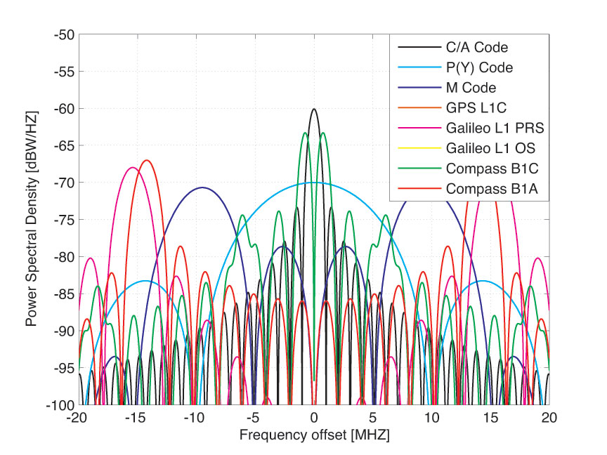
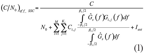
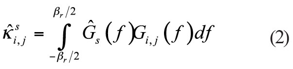
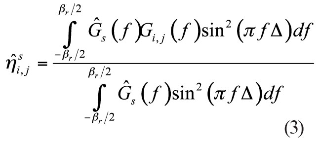
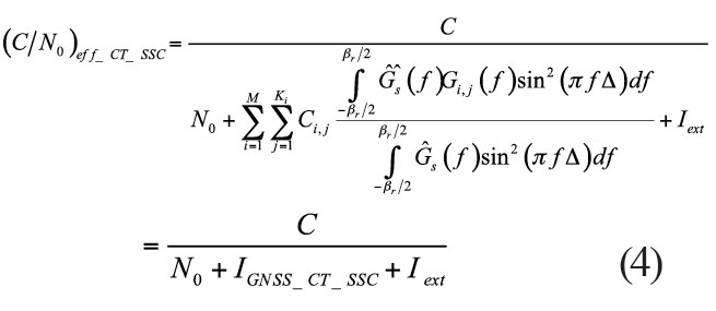
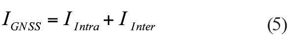


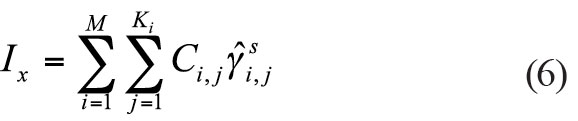
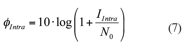
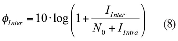
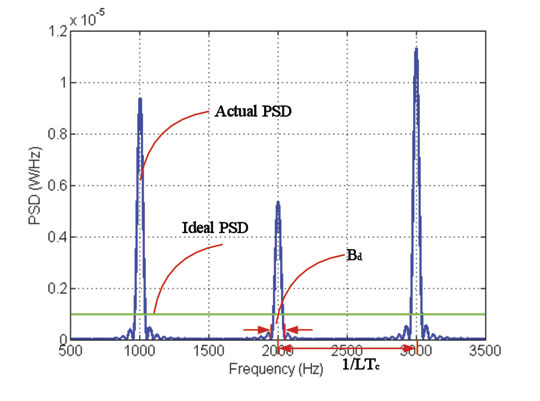
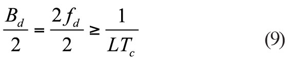
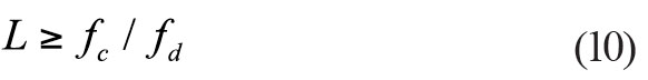
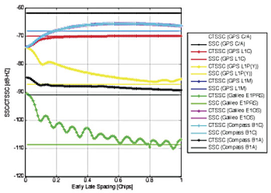
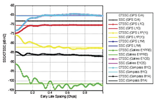


