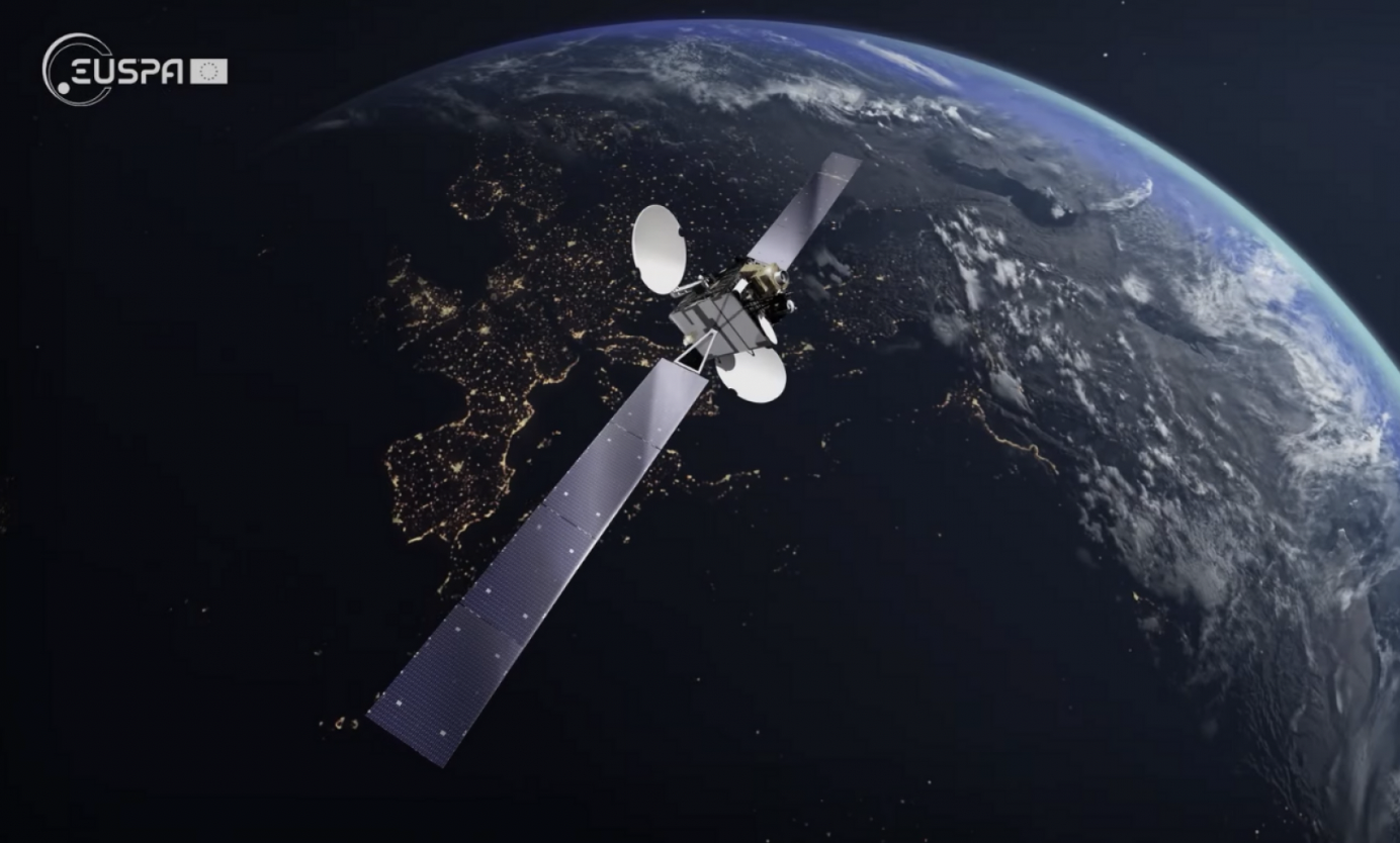
Europe’s regional satellite-based augmentation system (SBAS), EGNOS, has received upgrades to advance the reliability of GNSS positioning information, according to EUSPA.
Historically, EGNOS has provided safe, uninterrupted satellite navigation services to aviators, and some maritime, railroad, and land-based users in Europe. This system upgrade includes extending its service area, adding advanced functionalities, and reinforcing dual-frequency and multi-constellation services.
The EGNOS V242B system upgrade will expand services outside of its service area and enhance availability to users. Additionally, the upgrade ensures aviator access to lifesaving services such as Localizer Performance with Vertical Guidance (LPV)-200. The upgrade also includes more advanced data processing functions to cater to increased issues with peak solar activity and ionospheric phenomena that interfere with EGNOS signals and services.
Dual-frequency and multi-constellation services were also improved in the EGNOS upgrade. The improvements revamped EGNOS Version 2, and reinforced EGNOS services before launching EGNOS Version 3 (V3).
EGNOS delivers two frequencies and has amplified Galileo signals, hence creating a multi-constellation capability. When EGNOS V3 is launched, it will offer additional services and enhance protection against cyberattacks, further advancing EGNOS’ safety-critical applications across Europe.
The Ministerial Council of the member states of the European Space Agency (ESA) has pledged 351 million euros to ESA’s board of directors for navigation to aid in multiple satellite navigation endeavors.
This funding helps support ESA’s FutureNAV program, the Navigation Innovation and Support Program (NAVISP), and the Moonlight Initiative, developed for lunar telecommunications and navigation coverage and innovation.
The FutureNAV program is aimed at addressing the rapidly growing need for more ubiquitous, resilient and reliable positioning, navigation and timing (PNT). Its first mission consists of an initial in-orbit demonstration, small constellation of low-Earth-orbit (LEO) navigation satellites. The LEO-PNT satellites will test a multi-layer approach to deliver more accurate and robust PNT services, supplementing Galileo.
The second FutureNAV mission, GENESIS, will map the moving contours of Earth, while enhancing the accuracy of Galileo.
The expanded funding will also be invested in NAVISP. The program has already began working on over 200 projects relating to satellite navigation, PNT research, and backing Member States in research priorities.
Lastly, funding is being delegated to the Moonlight Initiative, a project designed by ESA to extend satellite navigation and telecommunications coverage to the Moon. The advancement and launch of Moonlight infrastructure on the Moon will undertake several missions bolstering future Moon exploration.
Position Partners has unveiled SmartSurveyor, which facilitates accurate, survey-grade aerial mapping and photogrammetry without the need for a connection between a camera shutter and a GNSS receiver.
The fully compact, handheld, aerial mapping survey rover is compatible with DJI Mavix 2 and 3 series and Phantom 4 Pro drones.
Image: Position Partners
The design is dissimilar to other drone mapping systems in that it works from a drone or smartphone and with two or more ground control points (GCPs) while using an ultra-matching technique.
Once data is captured by SmartSurveyor, all the photos and the GNSS file are uploaded to a PC and analyzed through the Agisoft UltraMatch workflow to confirm their accuracy before they are exported. Data can be managed in the cloud or on a local PC using software designed by MapSender.
Additionally, this mapping tool works in tandem with the AllDayRTK subscription GNSS network service so collected data can be uploaded to Tokara to remotely manage a project.
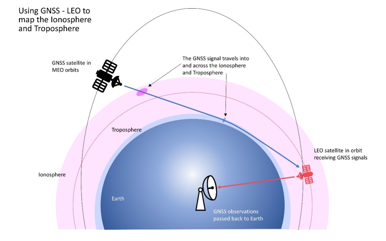
FrontierSI has signed a collaborative agreement with Geoscience Australia, Curtin University and the University of Newcastle to enhance Ginan with features specifically aimed at supporting low-Earth orbit (LEO) satellites as an important component of Geoscience Australia’s Positioning Australia program.
Ginan is Geoscience Australia’s GNSS analysis center software. It delivers a real-time positioning correction service through open-source software and additional positioning products to enable precise point positioning for Australian industry and users.
The design, development and deployment of LEO satellites has grown significantly over the last decade. The agreement with FrontierSI complements ongoing Ginan precise orbit determination (POD) development activities, focusing on the implementation of LEO satellite modeling and the orbit integrator/propagator capabilities needed to enable LEO GNSS data to be processed and high-precision LEO satellite trajectories estimated and predicted.
Such a capability will enable:
better monitoring of LEO satellites for station keeping, collision avoidance and end-of-life purposes
improved ionosphere and troposphere monitoring and modeling through the analysis of GNSS signal occultation, to provide data for weather prediction and precise positioning purposes.
What works well and what needs improvement in the GPS program regarding technology, policy, or management?
Jules McNeff
“GPS technology and operational performance continue to set the standard for GNSS, but necessary modernization is late to need, and becoming later by the day. This reflects what I see as loss of focus on ‘Job 1’ (delivering effective GPS service to the Joint Force) and a diminution in the sense of ‘GPS uniqueness and exceptionalism’ in its management as it was fragmented within the old SMC and is no longer the ‘shiny new object’ within the evolving Space Force. Even so, its value to its global user base, and particularly to U.S. and allied militaries, is stronger than ever and it remains the cornerstone among diverse complements within the Department of Defense PNT Enterprise. It is incumbent on the DOD to ensure the GPS services our warfighters will depend on can sustain that vital role.”
— Jules McNeff Overlook Systems Technologies
Ellen Hall
“What works well? There is good focus on the areas that need development: M-code, CRPA, resiliency. What needs improvement? More thorough and timely sharing of information by the government with industry.” — Ellen Hall, Spirent Federal Systems
Mitch Narins
“The ‘GPS program’ has set the standard for all other GNSS efforts, but there are always lessons to be learned. I have full confidence that USSF leadership is well equipped to deal with both the technology and management aspects of the program. As for policy, which supports military and civil uses worldwide, there is a clear distinction, based on mission areas and acceptable risk. However, risks to civil users have increased as GPS PNT services permeate all civil critical infrastructure systems. Therefore, system improvements directed at civil user PNT resilience should be given a higher priority and funded through appropriate civil channels. I encourage a policy to enable more resilient PNT services from space — and to consider that by looking both ‘up’ and ‘down’ for PNT services, unfortunate ‘situations’ might be avoided.” — Mitch Narins,
Strategic Synergies
Bernard Gruber
“One of the most consistent and enduring enablers of the GPS program is national policy. NSPD-39 re-baselined requirements buttressed by GPS being provided to the world for free, that it must be sustained and have an ever-present focus on performance improvement and robustness. Accordingly, NSPD-7 acknowledges an ever-changing world with a nod to cybersecurity, augmentations and direction to “improve NAVWAR capabilities to deny hostile use of United States Government space-based PNT services, without unduly disrupting civil and commercial access to civil PNT services.” — Bernard Gruber,
Northrop Grumman
The three new GPS satellites will be delivered under the third production option of the GPS III contract
Space Systems Command (SSC), a division of the U.S. Space Force, has exercised its third production option valued at $744 million for the procurement of three additional GPS III Follow-On satellites from Lockheed Martin.
The contract option covers GPS IIIF Space Vehicles (SVs) 18, 19 and 20.
GPS IIIF will provide several next-generation capabilities to meet increased demands of both military and civilian users. Building on the technical baseline of satellites 01 to 10, the newer satellites will provide increased anti-jam capabilities for the military with the addition of a Regional Military Protection capability.
Precision ranging measurements will be enabled by a laser retro-reflector array and will address the consolidation of telemetry, tracking and commanding frequencies.
Additionally, GPS IIIF leverages major international collaboration with the Canadian Department of National Defense and other U.S. government organizations such as the National Oceanic and Atmospheric Administration, the Air Force Rescue Coordination Center, and the U.S. Coast Guard Office of Search and Rescue (SAR) by hosting a new SAR payload.
This payload provides enhanced capabilities to the SAR mission with distress alert detection and location to 100 percent continuous global coverage and reduces location uncertainty to less than 5 km in support of 49 international partners.
Finally, the program will host a redesigned Nuclear Detonation Detection System that has a lower overall size, weight and power requirement.
“Along with our industry and government partners, the GPS IIIF team continues to add world-class capabilities that underpin U.S. national security needs to both our warfighters and civil users across the globe as the most utilized United States Space Force capability,” said Col. Jung Ha, GPS Space Vehicles senior materiel leader for SSC Military Communication and Positioning, Navigation and Timing.
The GPS IIIF SV11-12 satellites were included in the original GPS IIIF contract awarded to Lockheed Martin in September 2018 to build up to 22 GPS IIIF satellites. Under that contract, SSC exercised the first production option for SV13-14 in October 2020 and second production option for SV 15-17 in October 2021.
Artist’s rendering of a GPS III satellite. (Image: Lockheed Martin)
About Space Systems Command
Space Systems Command is the U.S. Space Force field command responsible for rapidly identifying, prototyping and fielding resilient space capabilities for joint warfighters.
SSC delivers sustainable joint space warfighting capabilities to defend the nation and its allies while disrupting adversaries in the contested space domain. SSC mission areas include launch acquisition and operations; space domain awareness; positioning, navigation, and timing; missile warning; satellite communication; and cross-mission ground, command and control and data.
GNSS researchers presented hundreds of papers at the 2022 Institute of Navigation (ION) GNSS+ conference, which took place Sept. 19–23 in Denver, Colorado, and virtually. The following five papers focused on atmospheric effects on GNSS signals. The papers are available at www.ion.org/publications/browse.cfm.
Addressing Scintillation Error
Mitigating the scintillation effect at low latitude is a complex matter: several kinds of experimental data must be collected, realistic models must be developed, and, most importantly, useful real-time indices and alerts must be made available.
The authors introduce a prototype based on a patent owned by SpacEarth Technology to address scintillation error detection and mitigation, supporting precision GNSS-based services at low latitudes in any season and space weather conditions. The patent relates to a method of total electron content (TEC) and scintillation empirical forecasting, in particular short-term forecasting (seconds to minutes). The output of the method is necessary to feed mitigation algorithms aiming at improving accuracy on GNSS precise positioning techniques (RTK, NRTK, and PPP) under ionospheric harsh conditions.
The prototype is designed with a Central Elaborating Facility, which collects the data provided by a network of GNSS monitoring stations detecting scintillation events, and broadcasts foreseen scintillation parameters. Users with a rover mitigation device can apply the parameters from the central facility for scintillation error mitigation.
Vincenzo Romano, INGV and SpacEarth Technology; Claudio Cesaroni, INGV; Luca Spogli, Alessandro Fiorini, INGV and SpacEarth Technology; Marco Fermi, Gter; Lorenzo Benvenuto, Gter and University of Genoa; Tiziano Cosso, Gter; Marcin Grzesiak, SRC/PAS; Joao Francisco Galera Monico, Italo Tsuchiya, UNESP; Gabriel Oliveira, Marcos Guandalini; “Ionospheric Scintillation Mitigation at Low Latitude to Improve Navigation Quality.”
Ring of Fire GUARDIAN
Commonly, natural hazards release energy into the Earth’s atmosphere in the form of acoustic-gravity waves, which propagate up to the ionosphere. The resulting traveling ionospheric disturbances (TIDs) can be detected using GNSS signals, through the computation of the integrated total electron content (TEC) along the lines of sight between GNSS receivers and satellites. The global distribution of ground-based GNSS receivers constantly tracking multiple GNSS constellations (GPS, Galileo, GLONASS, BeiDou, and others) provides excellent spatio-temporal coverage around the world, including in areas of limited coverage by existing warning systems.
The authors present the operational GNSS-based Upper Atmospheric Real-time Disaster Information and Alert Network (GUARDIAN). Based on dual-frequency GNSS data from the Global Differential GPS (GDGPS) network of the Jet Propulsion Laboratory, the GUARDIAN architecture computes slant TEC time series in near real time.
As part of the GDGPS network, 78 stations around the Pacific ring of fire monitor the four GNSS constellations: GPS, Galileo, GLONASS and BeiDou. Cycle slips are corrected and the time series are filtered, both in real time. The resulting data stream is output live to a user-friendly public website, benefitting the general public and the scientific community.
The current GUARDIAN focuses on the Pacific region. However, the architecture can readily be extended to a worldwide coverage.
Léo Martire, S. Krishnamoorthy, L. J. Romans, B. Szilágyi, P. Vergados, A. W. Moore, A. Komjáthy, Y. E. Bar-Sever, A. B. Craddock, NASA Jet Propulsion Laboratory, California Institute of Technology; “GUARDIAN: A Near Real-Time Ionospheric Monitoring System for Natural Hazards Early Warnings.”
Civil Aviation Interference
The authors provide a survey on GNSS receiver architectures with emphasis on new carrier-tracking techniques for mitigating the adverse effect of ionospheric scintillation within the context of civil aviation. The survey is complemented by results gathered from simulations on the impact of ionospheric scintillation in conventional receiver architectures. A review on scintillation mitigation techniques is carried out, covering several “technique families,” highlighting their potential for performance improvement, as well as their shortcomings and challenges in implementation.
A semi-analytical simulation campaign is carried out for different modulations: L1, L5 for GPS, and E1, E5a for Galileo. Here, the performance of a standard receiver tracking a set of GPS and Galileo satellites affected by ionospheric scintillation is analyzed to pinpoint existing vulnerabilities to this effect.
The simulation results show that ionospheric scintillations are responsible for large variations in carrier-to-noise ratio, which in turn can be responsible for losses of lock and large phase variations, increasing phase RMSE and in some cases leading to cycle slips of the phase estimation. Thus, the adopted solution must be robust to signal power fluctuations and the occurrence of cycle slips and able to maintain phase lock.
António Negrinho, GMV-PT Pedro Boto, GMV-PT Marta Cueto, GMV-ES Mikael Mabilleau, EUSPA Claudia Paparini, EUSPA Ettore Canestri, EUSPA; “Survey on Signal Processing Techniques for GNSS Ionospheric Scintillation Mitigation.”
Tonga Eruption Data Analyzed
Extreme natural disasters, such as volcanic eruptions, can create visible pressure waves in the atmosphere and trigger observable ionospheric wave responses that can travel hundreds of kilometers in the ionosphere. The acoustic and gravity waves generated can cause ionospheric TEC perturbations and variations. The TEC determines the GNSS ionospheric delay and can cause significant positioning errors, which may affect the performance of GNSS-based applications.
The researchers processed GNSS data collected from the Hong Kong Satellite Positioning Reference Station Network to analyze the ionospheric activity and positioning performance responding to the Tonga volcanic eruption on Jan. 15, 2022. To detect and repair cycle-slip jumps, the researchers applied theTEC rate and Melbourne Wubbena Wide Lane (MWWL) linear combinations. A Savitzky-Golay low-pass filter with a 30s window was used to improve the TEC accuracy.
The team investigated the changes in TEC, Rate of TEC index (ROTI) and positioning errors in the eastward, northward and upward directions after the anomalous ionospheric propagation to Hong Kong between 11:30 and 14:30. The team found the ionospheric anomaly could generate large changes in the three parameters, with peaks up to three times the calm period. Their prompt research contributes to a better understanding of the coupling of extreme ionospheric activities and dynamics caused by volcanic eruptions.
Xiaojia Chang, Kai Guo, Zhipeng Wang, Kun Fang, Hongxia Wang, Beihang University; Hailong Chen, China Academy of Aerospace Electronics Technology; “Ionospheric Anomaly and GNSS Positioning Responses to the January 2022 Tonga Volcanic Eruption.”
Toolbox for Monitor Network
The MONITORtoolbox is a set of Python-coded software tools to perform automatized large-scale processing of data from the Monitor network of the European Space Agency (ESA). The Monitor network aims to continuously monitor ionospheric scintillation events from multiple ground stations strategically located around the globe. It accommodates a repository with a large number of GNSS measurements containing scintillation events for users to analyze scintillation data or for research purposes.
This paper shows the potential of the MONITORtoolbox for providing access to a large amount of data that otherwise, without a systematic processing, becomes practically useless. The software developed implements the means to collect data and store it in a local database for quick offline access. It detects the presence of scintillation events based on certain conditions and criteria defined by the user and identifies its properties in terms of duration, time of occurrence, intensity and satellite location. It implements the tools to compute relevant statistics, providing insights on ionospheric scintillation phenomena.
Sergi Locubiche-Serra, Alejandro Pérez-Conesa, Diego Fraile-Parra, Gonzalo Seco-Granados, José A. López-Salcedo, Universitat Autònoma de Barcelona, IEEC-CERES; Juan M. Parro-Jiménez, Raúl Orús-Pérez, ESTEC, European Space Agency; “MONITORtoolbox — Software Tool for the Analysis of Ionospheric Scintillation Data from the ESA Monitor Network.”
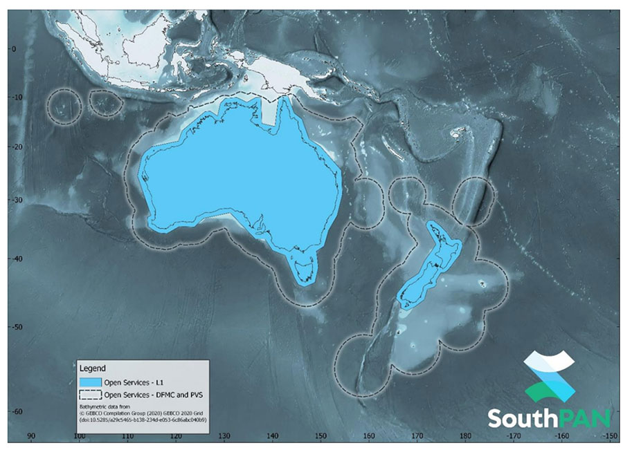
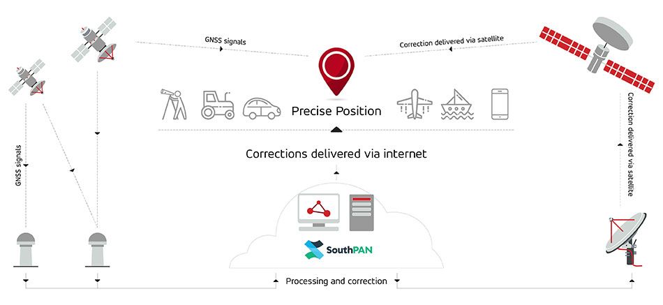
Multinational technology firm GMV has signed an agreement with Lockheed Martin Corporation to develop the processing and control centers for the Southern Positioning Augmentation Network system (SouthPAN). Lockheed is contracted to establish SouthPAN.
The project is a joint initiative of the Australian and New Zealand governments to provide a satellite-based augmentation system (SBAS) for navigation and precise point positioning (PPP) services. GMV will also be responsible for monitoring both of these services in the region and for ensuring compliance with the committed performance levels.
SBAS and PPP systems have applications in industries as diverse as agriculture and road, air, maritime and rail transportation, as well as in the field of geomatics. SouthPAN is expected to accelerate development of applications in these areas.
SouthPAN is also the first system with these characteristics available in the Southern Hemisphere. With this new program, Australia and New Zealand will be contributing to improved global coverage and interoperability for services of this type, joining the list of countries and regions that already have their own SBAS system: the United States (WAAS), Europe (EGNOS), India (GAGAN) and Japan (MSAS).
On Sept. 26, two weeks after the agreement was signed, the first services were provided by activating transmission of the system’s first signals. This was a significant milestone, because SouthPAN is the first project where an industry consortium provides an SBAS as a service, rather than as a turnkey system.
Image: SouthPAN
GMV’s role
GMV will be responsible for developing two key subsystems for SouthPAN: the Corrections Processing Facility and the Ground Control Center. The company will also be responsible for monitoring the system and ensuring it complies with the committed performance levels.
GMV also will provide support for the system’s operation and maintenance.
Corrections Processing Facility. The facility generates correction messages for signals transmitted by GPS and Galileo, improving precision for users by improving accuracy to as little as 10 centimeters.
The facility also detects malfunctions in the satellites and generates warnings for users. This will allow use of SouthPAN by civilian aircraft as a navigation system during various flight operations, including precision approaches to runways for landing.
Safety-of-life services such as these will be available in 2028.
SouthPAN early Open Services coverage. OS-L1 covers mainland Australia and New Zealand. OS-DFMC and OS-PVS cover Exclusive Economic Zones in both countries. (Image: Geosciences Australia)
Ground Control Center. The control center remains in operation 24 hours a day seven days a week, and will perform all the functions needed to monitor and control the system. It will also provide information to users about the system’s operation and availability of services.
In Australia, SouthPAN development, entry into service and operation are being supervised by Geoscience Australia in collaboration with Toitū Te Whenua Land Information New Zealand.
In 2020, the two agencies signed the Australia New Zealand Science, Research and Innovation Cooperation Agreement (ANZSRICA). Over the next 20 years, the Australian government will be contributing 1.4 billion Australian dollars to the SouthPAN project.
Swift Navigation has expanded the capabilities of its Skylark precise positioning service to several product tiers. With new services providing real-time kinematic (RTK) and differential GNSS (DGNSS) options, Swift meets the broadening needs of its growing customer base.
In addition, new BeiDou signal support and regional coverage has been added.
Skylark is Swift’s cloud-based GNSS corrections service designed to deliver affordability, high accuracy and fast convergence, eliminating the complexity of deploying and maintaining GNSS networks. The expansion of Skylark’s capabilities makes it possible for customers across industries to benefit from seamless corrections to applications across the globe, the company said.
Skylark RTK delivers Swift’s highest tier of performance to third-party GNSS receivers. Compatible with leading RTK receivers on the market, Skylark RTK delivers corrections for applications that require sub-2 cm accuracy, including agriculture, machine control, drones and robotics in the United States, Europe and select Asian countries.
Skylark DGNSS is suitable for mobile applications, delivering real-time, high-reliability differential GNSS corrections to mobile handsets, positioning engine modules and mass-market applications. Skylark DGNSS enables lane-level location accuracy, in turn enabling new consumer location experiences and improving location-based services to increase efficiency on a global basis.
With BeiDou coverage already available across the United States, Japan and Korea, Swift has now added BeiDou signal support for the European Union, supplementing existing support for Galileo and GPS by providing corrections for GPS L1/L2/L5, Galileo E1/E5b/E5a and BeiDou B1/B2a. In addition, support for BeiDou B1C has been added to all regions.
These additions help support newer mass-market RTK-enabled receivers to achieve high-accuracy performance in difficult GNSS environments and continue to push the envelope for positioning accuracy.
“Swift was founded on the notion of improving GNSS positioning performance for mass-market applications,” said Holger Ippach, executive vice president of product, Swift Navigation . “We are pleased to expand the functionality of Skylark to improve the positioning functionality for many more customers across the globe.”
The suite of Skylark products was built from the ground up for scale, resilience and ease of integration. Skylark delivers seamless corrections to continents and countries across the globe including the United States, Europe, South Korea, Japan, Taiwan and Australia.
Researchers at Delft University of Technology, Vrije Universiteit Amsterdam and VSL have developed an alternative positioning system that is more robust and accurate than GPS, especially in urban settings.
The aim of the project — SuperGPS — was to develop an alternative positioning system that makes use of the mobile telecommunication network instead of satellites and that has better accuracy than GPS.
The working prototype that demonstrated this new mobile network infrastructure achieved an accuracy of 10 centimeters.
The new technology is important for the implementation of a range of location-based applications, including automated vehicles, quantum communication and next-generation mobile communication systems.
Much of our vital infrastructure relies on GNSS. Yet systems that rely on satellites have limitations and vulnerabilities. For instance, their radio signals are weak when received on Earth, making accurate positioning no longer possible if the radio signals are reflected or blocked by buildings.
“We realized that with a few cutting-edge innovations, the telecommunication network could be transformed into a very accurate alternative positioning system that is independent of GPS,” said Jeroen Koelemeij of Vrije Universiteit Amsterdam. “We have succeeded and have successfully developed a system that can provide connectivity just like existing mobile and Wi-Fi networks do, as well as accurate positioning and time distribution like GPS.”
Illustration: TU Delft / Stephan Timmers
One innovation is to connect the mobile network to a very accurate atomic clock so that it can broadcast perfectly timed messages for positioning, just like GPS satellites do with the help of the atomic clocks they carry on board. These connections are made through the existing fiber-optic network.
“With these techniques, we can turn the network into a nationwide distributed atomic clock — with many new applications such as very accurate positioning through mobile networks,” said Erik Dierikx, VSL. “With the hybrid optical-wireless system that we have demonstrated now, in principle anyone can have wireless access to the national time produced at VSL. It basically forms an extremely accurate radio clock that is good to one billionth of a second.”
The system also employs radio signals with a bandwidth much larger than commonly used. “Buildings reflect radio signals, which can confuse navigation devices. The large bandwidth of our system helps sorting out these confusing signal reflections, and enables higher positioning accuracy,” explained Gerard Janssen of Delft University of Technology. “At the same time, bandwidth within the radio spectrum is scarce and therefore expensive. We circumvent this by using a number of related small bandwidth radio signals spread over a large virtual bandwidth. This has the advantage that only a small fraction of the virtual bandwidth is actually used and the signals can be very similar to those of mobile phones.”
The results of the peer-reviewed research have been published in Nature.
Speaking at the National Press Club on Nov. 3, Federal Communications Commission (FCC) Chair Jessica Rosenworcel announced a plan to reorganize the agency to include a Space Bureau and a standalone Office of International Affairs.
The rationale for these moves, as explained in a press release, is to “help ensure that the FCC’s resources are better aligned so that the agency can continue to fulfill its statutory obligations and keep pace with the rapidly changing realities of the satellite industry and global communications policy.”
While neither GPS nor Ligado were mentioned in the press release, some have taken establishment of a Space Bureau as a sign the FCC may be reconsidering its decision regarding Ligado Networks.
By creating a Space Bureau, the reasoning goes, the commission is acknowledging a need to better focus on space-based users. A report this summer from the National Academies of Science said that some GPS and Iridium users would be harmed if Ligado Networks is allowed to operate as planned.
Since the commission seems to be trying to prevent future Ligado-like controversies, it may also be ready to reconsider its Ligado decision. In February 2020 seven different petitions were filed by organizations and groups of organizations formally asking the FCC to reconsider. The commission has not yet responded to any of the petitions.
Few can disagree that aligning resources to more effective address constituent concerns is a good idea. At the same time reorganizations rarely, in and of themselves, prevent problems from recurring.
As one example, the FCC had been criticized for years for not including analyses of total costs and benefits to the nation of decisions it was considering. In January 2018, FCC Chairman Ajit Pai established the FCC’s Office of Economic Analysis to address those concerns.
Yet, despite Pai still being chair, the Office of Economic Analysis was not called upon to provide input to the commission’s deliberations on Ligado Network’s application. One of the pending petitions for reconsideration asserts that if the office had done a cost-benefit analysis, the commission’s decision would have been different. This is because the cost of even a small service degradation for potentially millions of GPS users would have very likely easily outweighed any benefit to the nation of granting Ligado Networks permission to operate.
Photo: Bill Oxford/iStock/Getty Images Plus/Getty Images
The companies will combine their experience to guarantee robust and reliable navigation thanks to the Galileo constellation
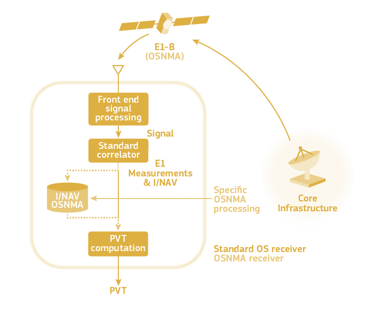
The OSNMA scheme. (Image: ESA)
UAV Navigation is participating in the OSNMAplus project consortium led by Qascom, an Italian enterprise in the domain of GNSS authentication.
The OSNMAplus project aims to develop services and technologies that make use of novel services provided by Galileo, particularly use of OSNMA and I/NAV improvements.
The OSNMA service is a data authentication function for Galileo Open Service users worldwide, freely accessible to all. OSNMA provides receivers with the assurance that the received Galileo navigation message is coming from the system itself and has not been modified. The I/NAV improvements are part of a recently released update of the Galileo Interface Control Document, aiming at optimizing the navigation performance of Galileo even further.
“With the OSNMAplus project, we’re providing technological solutions that will facilitate the adoption of OSNMA in new and existing navigation systems,” said Carlo Sarto, OSNMAplus project manager. “We’re also providing cloud-based services and multiplatform SDK that can be used in consumer devices to improve the OSNMA experience and increase the robustness of the navigation solution.”
The OSNMAplus technologies will be subject to an extensive test campaign. The OSNMA-based navigation will be tested in a flying drone to assess effective resilience against potential malicious GNSS interference.