Thales Alenia Space is a joint company between Thales (67%) and Leonardo (33%).
EGNOS enhances the accuracy, reliability and integrity of positioning signals by improving the performance of GNSS. For instance, the EGNOS safety-of-life service is used in aviation for landings, enabling precision approaches at European airports without requiring ground guidance systems. The service has significantly improved operational safety and efficiency for European aviation.
Thales Alenia Space will build on its expertise in engineering, development, testing and maintenance of the existing EGNOS, along with its current development of EGNOS V2, to provide maintenance of the EGNOS V2 system for EUSPA and the European Union satellite navigation community from 2023 to 2026.
Thales Alenia Space will provide operational support and servicing in case of incidents — especially hardware and software troubleshooting and repairs — to deliver optimal 24/7 support for EGNOS. In addition, it will provide the upgraded or modified versions needed to ensure safety-of-life service.
News from the U.S. Air Force Research Laboratory (AFRL)
The Navigation Technology Satellite-3 (NTS-3) Vanguard program has reached a milestone in preparation for launch of the satellite in late 2023. NTS-3 is expected to push the boundary of positioning, navigation and timing (PNT) technology, paving the way for a more flexible, robust and resilient architecture for satellite navigation.
Prime contractor L3Harris Technologies delivered the NTS-3 space vehicle to an Air Force Research Laboratory (AFRL) integration and test facility at Kirtland Air Force Base, New Mexico. The satellite integrates an agile PNT payload with a Northrop Grumman ESPAStar bus to provide a space platform for AFRL and partner organization experiments and integrated capability demonstrations.
In 2019, the U.S. Air Force designated NTS-3 one of the first three Vanguard programs to deliver innovative, game-changing capabilities to the warfighter at an accelerated pace. NTS-3 is managed by the AFRL Transformational Capabilities Office and has program partners in both the U.S. Space Force and the U.S. Air Force.
“This major milestone marks the transition from space system development at contractor’s facilities to the final stage of integration and test activities,” said Arlen Biersgreen, NTS-3 program manager. “The AFRL team will be overseeing and working closely with L3Harris and other key industry partners to apply an effective combination of contractor and government resources to successfully complete this phase of the effort.”
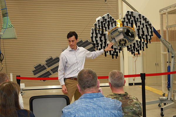
Arlen Biersgreen, NTS-3 program manager, uses a 1:3 scale model to describe the spacecraft and details of the one-year experimental mission during Media Day on June 23, 2022, at Kirtland Air Force Base. (Photo: U.S. Air Force/Andrea Rael)
AFRL and L3Harris are now completing the remaining intra-payload and payload-to-bus functional and performance tests, including the first radio frequency broadcast tests of the novel PNT signals that will be demonstrated from near-geosynchronous orbit after the NTS-3 launch.
Following those activities, the team will perform standard space environment tests that simulate the launch and space environments to verify that the system is ready for the rigors of experimental operations in space. Biersgreen added that experimental performance data from ground testing will be available for sharing with program partners in the next several months.
The Global Navigation Satellite System Test Architecture, or GNSSTA, developed by the Mitre Corporation in partnership with the AFRL Sensors Directorate, is crucial for meeting end-to-end NTS-3 mission objectives. GNSSTA is a reprogrammable software-defined receiver allowing users to receive both legacy GPS and advanced signals generated by NTS-3. It lays the groundwork for future operational receivers to provide the Space Force with options to prevent and respond quickly to common threats on the battlefield, such as GPS jamming and spoofing.
Joanna Hinks, NTS-3 principal investigator, worked closely with the Sensors team on GNSSTA development and testing. “The entire team is excited that earlier this month, we successfully generated signals on the actual spacecraft and received them with our experimental GNSSTA user equipment,” Hinks said. “Showing the space segment and user segment working together like that is an important step to being ready to conduct experiments on-orbit.”
NTS-3 is the first U.S. experiment of its kind in nearly 50 years, since the Navy Research Laboratory’s NTS-1 and NTS-2 spacecraft led the way for the GPS constellation in the 1970s.
“This Vanguard not only aims to support GPS users through vital development of new technologies and techniques, but also to show how an agile and responsive U.S. satellite navigation architecture is paramount to defeating the most challenging threats to warfighter success, both today and through the coming decades,” Biersgreen said.
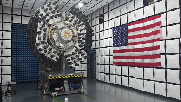
The NTS-3 spacecraft was placed in an anechoic test chamber for electromagnetic interference and electromagnetic compatibility testing in Palm Bay, Florida. (Photo: AFRL)
Lockheed Martin has developed a satellite-based augmentation system (SBAS), which uses signals from the GPS and Galileo constellations, according to a report by Space News.
The second-generation SBAS uses both GPS L1 and L5 and Galileo E1 and E5 signals to provide accurate navigation and positioning and to reduce dependence on just one system. The SBAS broadcasts on two frequencies to augment the signals from both GPS and Galileo.
Image: EUSPA
In September 2022, Lockheed Martin won a $1.18 billion 19-year contract to develop and operate the Southern Positioning Augmentation System Network (SouthPAN) for Australia and New Zealand. The company is also having discussions with other potential international customers.
As a part SouthPAN, the dual-frequency multiple constellation SBAS signal is being broadcast. As more GPS III and GPS IIIF satellites are launched, including one Jan. 18, service will continue to improve.
It was 2018. Representatives from the European Space Agency were visiting Google headquarters in Mountainview, California.
Under discussion was Europe’s plans to introduce a high accuracy and authentication service to their Galileo satellite navigation system. Galileo would broadcast precise point positioning corrections on the E6-B band and provide users decimeter-level accuracy. They would also be including a navigation authentication message enabling receivers to distinguish genuine messages from deceptive ones sent by spoofers.
Wouldn’t Google like to incorporate these capabilities in future versions of Android phones?
The answer from Google Distinguished Engineer, Frank van Diggelen, was a resounding “yes.”
Technologically Possible
Van Diggelen also had another thought. It should be possible to deliver precise positioning corrections and authentication data via the internet. This could allow phones with an internet connection to access the services as well. With an app, older smartphones would be able to take advantage of the services, and it wouldn’t be necessary to add new hardware to new phone designs.
The next logical step was to establish an internet-based high accuracy and authentication service for the United States’ GPS. Unlike the newer European Galileo and Chinese Beidou systems, GPS satellites don’t have the ability to transmit data to improve accuracy and authenticate signals.
Yet a couple of process challenges in the United States could make establishing such a service difficult and might prevent its creation entirely.
Data collection and use not yet an official program
The first is related to the way in which the U.S. collects and handles real-time tracking data of the Global Navigation Satellite Systems (GNSS) — GPS, GLONASS, Galileo, and BeiDou — to derive corrections needed for a high accuracy service.
NASA’s Jet Propulsion Laboratory (JPL) operates NASA’s Global GNSS Network (GGN) of more than 60 stations around the globe, which provide their tracking data to JPL’s Global Differential GPS (GDGPS) System. The GDGPS System also has access to real-time tracking data from hundreds of additional sites, all of which track GPS and other GNSS. This allows the GDGPS System to generate precise corrections for the navigation messages of GPS and other GNSS. It also enables real time decimeter-level accuracy for positioning applications anywhere in the world. These corrections are provided to some government agencies and commercial entities on a reimbursable basis.
NASA’s GDGPS capabilities are not part of a formal, official government program, though. Rather they have grown organically as part of JPL’s efforts to push boundaries in scientific and engineering applications of GNSS, and its ability to take on work paid for by other agencies. Thus, GDGPS efforts lack a sufficient and established government funding line, formal programmatic tasking, and other structures and procedures needed to ensure its long-term viability as a government-provided service.
NASA and JPL officials recognized this and in 2020 established a working group to advise on how they should go forward. The following year that working group made several recommendations to NASA and the PNTAB. Among them were to establish a consistent level of NASA funding, create a Level-1 capabilities document for GDGPS, and start discussions towards an interagency memorandum of understanding (MOU) for long-term government funding.
At the same time, a PNTAB task force investigated the GDGPS activity and made recommendations to the PNTAB. They included: that NASA/JPL document GDGPS capabilities, including architecture, facilities, functions and products; that a stable government funding line for GDGPS be established; that a security review of GDGPS be undertaken; and to maintain GDGPS entrepreneurial aspects in pursuing multi-agency usage of its services.
Civil GPS rarely needs addressed
The second challenge to establishing high accuracy and authentication service for GPS appears to be the lack of an identified agent or mechanism within the federal government to do so.
Europe’s Galileo is a civilian system established and operated to support economic activity and development. The U.S’s GPS is run by the military.
First created to “put five bombs in the same hole,” it was built and run for years by the U.S. Air Force and is now the responsibility of the U.S. Space Force. Its primary mission is support of military missions and almost all funding comes through the Department of Defense (DOD).
Yet, indisputably, 99% of GPS users are not in the military and the system has become essential to most technologies and nearly every facet of the U.S. economy.
Official government policy has long recognized this, at least at the strategic level. Presidential policies issued in 2004 and in 2021 provided for improvements in functionality for civil users – as long as they were required by and entirely funded by a civil agency.
At a more tactical level, though, attempts to fund civil requirements have always faced great difficulty and rarely succeeded.* Mandates in presidential directives for civil signal monitoring, interference detection and mitigation, increased resilience, alternative PNT, and responsible use have all faced uphill battles and received little funding.
According to former senior government officials, this difficulty stems from civil GPS use being caught in a bureaucratic “Catch-22.”
On the one hand, executive branch policy dictates that funding for GPS capabilities and applications benefiting civil users must flow through the Department of Transportation (DOT). On the other, within government programming and budgeting circles, GPS is seen as an expensive military capability funded through the DOD. Requests for GPS and PNT-related funding through DOT are more difficult to explain and are easier to deny.
Compounding this difficulty is the lack of a clear and empowered national leader to advocate for a comprehensive and national approach to GPS and PNT issues and overcome bureaucratic snags.
As a result, the path forward for adopting the recommendation for a GPS high accuracy and resilience service is, at best, unclear.
Yet many on the President’s advisory board and in government are hopeful. “Establishing a high accuracy and resilience service for GPS is the right thing to do” said one. “We have all the pieces to make this happen. We just need to bring them together.”
And as one of the board members commented at the recent meeting, if the U.S. doesn’t do this “It stinks.”
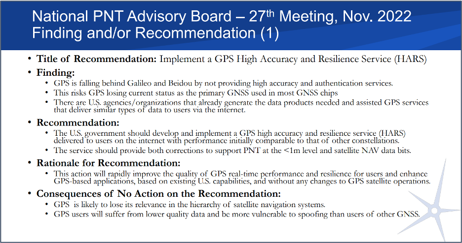
Image: Slide from the National PNT Advisory Board Meeting in November 2022
*The exception to difficulties funding civil GPS-related capabilities is the Federal Aviation Administration’s Wide Area Augmentation System. It was established as the result of heavy lobbying by the airline industry, which continues to give it strong support.
The high-accuracy service (HAS) offered by Galileo is now available and provides sub-meter accuracy over most of the globe. It will help enable emerging technologies such as UAVs and autonomous vehicles, which require stringent levels of accuracy for better navigation, safety and efficient traffic management.
Other industries expected to benefit include transportation, agriculture, geodesy and entertainment.
Thierry Breton, European commissioner for Internal Market, announced that the service was now live during the annual European Space Conference in Brussels, Belgium, on Jan. 24.
The European Union Agency for the Space Programme (EUSPA) developed Galileo HAS along with the European Commission and the European Space Agency (ESA). The new service will become a pillar of government programs such as EU sectorial policies and national policies by EU Member States.
“This new service has been made possible thanks to the outstanding cooperation and team commitment of all involved partners,” said Rodrigo da Costa, EUSPA executive director.
“Galileo is not standing still,” said Javier Benedicto, ESA director of navigation. “This new High Accuracy Service offers a new dimension of precision to everyone who needs it, while the Open Service Navigation Message Authentication — already available — allows users to authenticate Galileo signals as they make use of it, to minimize any risk of spoofing. An upgraded integrity message of the signal rolled out last year reduces the time to first fix while enhancing the overall robustness of Galileo.”
Galileo HAS delivers horizontal accuracy down to 20 cm and vertical accuracy of 40 cm in nominal use conditions, according to ESA. The service is transmitted directly via the Galileo signal in space (E6-B) and through the internet.
With HAS, Galileo becomes the first constellation worldwide able to provide a high-accuracy service globally and directly through the signal in space.
The service is freely accessible to all users with a receiver capable of processing the HAS corrections broadcast in the E6-B signal and via the internet. The precise corrections provided by Galileo HAS will allow users to reduce the error associated with the orbit and clocks provided through the Galileo Open Service broadcast navigation messages and the GPS Standard Positioning Service navigation data.
“With the Galileo HAS we are ready to unleash the full potential of new technologies such as drones and bring autonomous driving closer to reality,’’ da Costa said. “At EUSPA, our role is to link space to user needs. With the launch of this new service, we met a clear market demand for accurate, robust, and reliable navigation.”
While single-base real-time kinematics RTK can, under specific conditions, be the best option for certain applications in surveying and construction, corrections services typically eschew this solution in favor of network RTK, PPP, and PPP-RTK. There are, though, some agricultural networks made up of clusters of reference stations delivering RTK corrections. (Images: courtesy of Gavin Schrock and Courtney Townsend Bigmouse108/iStock / Getty Images/Gettu Images)
The boom in the development of corrections services for applications such as autonomy and robotics has brought a whole new slate of market players, and an expansion of services from established corrections providers. This has benefitted high-precision users as well as the new not-so-high-precision applications.
Whereas very high precision — centimeters — is of paramount importance to sectors such as precision agriculture, construction automation, surveying and mapping, new market sectors are less concerned with precision as they are with reliability, availability and resilience. There are many corrections services that can deliver reliable lane-level precision, decimeter precision, sub-meter or whatever the application requires.
Corrections have been around in various forms for nearly 30 years. Whereas traditional high-precision applications would access corrections services or network infrastructure directly, the user of a mass-market application, such as assisted or autonomous driving, receives corrections second or third hand.
A car manufacturer may install an integrated navigation and positioning system (GNSS is typically only one of many technologies in a complete system) from a vendor that receives corrections from one or more corrections services.
A Recap of the Technology
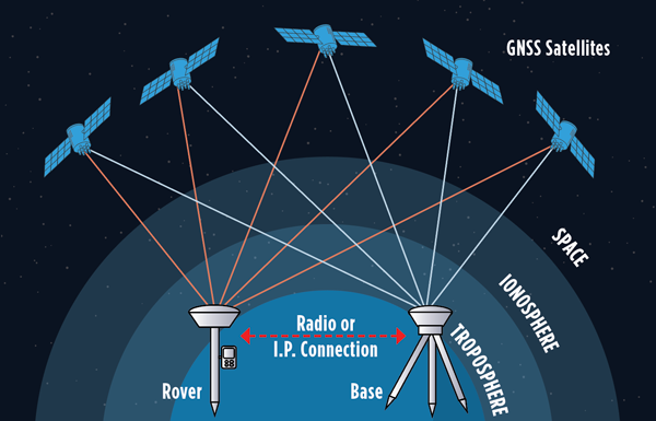
Uncorrected GNSS is limited to precisions in meters. This may be fine for many purposes, such as coarse navigation and local-based apps. However, for high precision uses, external augmentations (commonly referred to as “corrections”) add more and higher accuracy data to help mitigate multiple sources of error that otherwise limit standalone GNSS results. Various augmented data can be delivered via radio, the internet, or communications satellites. Delivery of augmentations by public or commercial generators of this add-on data is broadly referred to as “positioning services.”
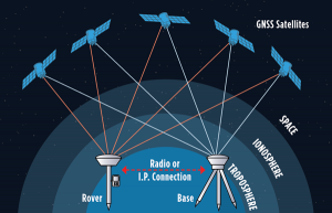
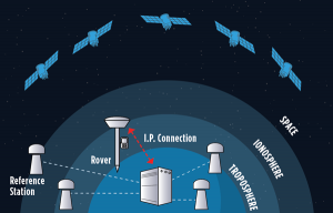
Network RTK, implemented as real-time networks (RTN), covers hundreds of localities, states, and entire countries and is a go-to for many applications in surveying, mapping, construction, monitoring and agriculture. One disadvantage, compared to PPP, is reliance on terrestrial IP communications. (Images: courtesy of Gavin Schrock and Courtney Townsend Bigmouse108/iStock / Getty Images/Gettu Images)
There are two fundamental approaches to generating corrections: Observation Space Representation (OSR) and State Space Representation (SSR). OSR uses observations of one or more base receivers to derive correction values representative of local conditions. Examples of OSR include base-rover real-time kinematics (RTK) and network RTK (NRTK). SSR provides “states” of conditions derived from terrestrial tracking networks, to improve clock and orbit “products,” and may also include data from global, regional, or localized ionospheric and tropospheric models. Examples of SSR include precise point positioning (PPP) solutions.
Players in the corrections services sector include vendors who manufacture GNSS hardware, RTK systems, and NRTK software. One example is real-time networks (RTN), which have grown to cover hundreds of localities, states, regions, and even entire countries. Some of these vendors now operate their own wide region RTN. The same large vendors also have developed global PPP services. The most recent decade though has seen rapid growth in new corrections service providers that focus on one or more key markets and develop approaches specifically to serve them. For instance, many agricultural regions of the world have large clusters of RTK stations operated by a vendor or a cooperative. Some newer vendors, focused on the autonomy market, have developed global PPP services, regional NRTK, or hybrids for decimeter to meter precision. One Achilles heel of PPP is its relatively poor vertical precision compared to RTK and NRTK. This partly explains why adoption has been slow for certain high-precision applications, such as surveying.
Where corrections services have become quite interesting, is in amalgams of these approaches. In recent years, the rapid expansion of corrections services for mass-market applications has given rise to what developers call PPP-RTK. Ostensibly, this is to take advantage of the strengths in each approach, however it may be more about trade-offs between precision and the practicalities of serving wide regions in a cost-effective manner. There are many variations on how this hybridization is achieved; for example, PPP- ambiguity resolution (PPP-AR). PPP-RTK can be somewhat of a nebulous term, much in the same way as the term “AI” gets used. Developers of the specific PPP-RTK approaches for the many corrections services keep certain details close to their chests. Clients are less concerned with how it works as they are with the results.
Examples of Vendors
In compiling the following list, we tried to provide examples of all aspects of the corrections service industry — from GNSS network software development to hosting of national and regional networks to providing global PPP. This segment continues to grow; new players continue to develop solutions and enter the market, some with great fanfare, while others seek to stay under the radar. This list does not include the many hundreds of RTN worldwide — local, regional, or national — though the key providers of the NRTK software these networks use are listed.
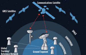
One advantage of PPP and PPP-RTK over RTK and NRTK is that they can deliver augmentations by satellites, eliminating reliance on terrestrial communications networks. Satellite delivery has a downside: the number of communications satellites broadcasting the augmentations is limited, which can be problematic in sky-view challenged areas. (Image: courtesy of Gavin Schrock and Courtney Townsend Bigmouse108/iStock / Getty Images/Gettu Images)
Note that other vendors are also not listed, such as some that seek to limit their visibility to specific clients and partners. For example, some offer corrections services as an adjunct to inside hardware/software sales, and others work with developers of certain integrated navigation/autonomy systems. In addition, some of the smaller vendors may be working in conjunction with some of the more established developers, often licensing elements of their software, and in many instances piggybacking on their global tracking networks.
In alphabetical order: Atlas. From Hemisphere GNSS. A global PPP service delivered by L-band satellites. It includes tiered precision for different applications, such as surveying, mapping, and asset management. Atlas Basic, Atlas H30, Atlas H10: bit.ly/3V42qxj. CHCNAV. CPS NRTK software: bit.ly/3FI6zlN. It also hosts various RTN and has a global network partner program: bit.ly/3VQugOr. CNH. Advance Farming Software (AFS) RTK+ network delivering corrections mostly via cellular to primarily precision agriculture users: bit.ly/3YiCZur. DigiFarm. DigiFarm VBN. An example of another network that serves primarily agriculture users, however, it now has a spinoff to serve other high precision markets: bit.ly/3hgnYZs. eSurvey. GNSS NET, a VRS management software: bit.ly/3Py0uMp. Fugro. Global PPP corrections services; tiered precision for various applications, mostly maritime and marine construction. StarFix, SeaStar, MarineStar, OceanStar: bit.ly/3W4LkA8. Geo++. One of the first developers of GNSS network and PPP solutions. Its GNSMART software suite provides NRTK and SSR broadcast capabilities: bit.ly/3FhGE2Z. HERE Technologies. HD GNSS, a PPP-RTK solution for mass-market applications: bit.ly/3Fnle4H. Hi-Target. Hi-RTP, a global PPP- RTK service: bit.ly/3hi2xHv. IGS. International GNSS Service, a federation of agencies and research entities with a global tracking network of more than 400 reference stations. The IGS is a vital component of the global geodetic infrastructure. RTS is its real-time PPP service. It is not fast converging like many of the commercial services, but it is free for many applications. It is not broadcast via satellites, only via the internet: igs.org. Leica Geosystems. Part of Hexagon. Provider of NRTK software (Spider), and host of its own RTN covering various regions around the world (SmartNet), and global PPP (SmartLink): bit.ly/3uEwHb9. NovAtel. Part of Hexagon. Includes various tiers of PPP-RTK: RTK Assist, RTK Assist-Pro*, TerraStar-L, Oceanix, TerraStar-C PRO*, and TerraStar-X* (what NovAtel calls“RTK From the Sky”): bit.ly/3HzuqWh. Point One. RTK correction service called Polaris, available also via partners such as Bad Elf: bit.ly/3uPJGqA. Premium Positioning. RTKcorrections service called RTK Premium: bit.ly/3uT0xZi. Rx Networks. A mix of tiered positioning approaches for location- based applications. Truepoint. io (DGNSS, PPP, PPP-RTK): bit.ly/3We1rvT. SBAS (Public). Satellite-based augmentation systems, national or regional services. Like commercial PPP, SBAS corrections are mostly served via satellites. Public safety and civil aviation are the primary drivers for providing such services. For instance, in North America, the Wide Area Augmentation System (WAAS) was chartered by the Federal Aviation Administration (FAA). There are equivalent systems in Europe (EGNOS), India (GAGAN), Japan (MSAS and QZSS), Russia (SDCM), China (SNAS/BDSAS, which is still in development) and Australia and New Zealand (SouthPAN). Other systems are in development in South America and the Caribbean (SACCSA), Korea (KASS) and in Africa and the Indian Ocean (ASECNA). Sino/Comnav. CDC.NET CORS software, RTN software: bit.ly/3W56hvm. Swift Navigation. Skylark RTK and Skylark DGNSS services: bit.ly/3HyWVn5. Tersus GNSS. Tersus Advanced Positioning (TAP), a PPP service: bit.ly/3hoZkWD. Topcon. TopNet and Topnet Live. RTN Software, regional RTN, and PPP services: bit.ly/3FRRcaw. Trimble. RTN software, VRS Now (regional RTN), and tiered PPP services: CenterPoint RTX, RangePoint RTX, ViewPoint RTX, and FieldPoint RTX: bit.ly/3V3bbax. u-blox. PointPerfect regional PPP and PPP-RTK: bit.ly/3FPVmQo. Veripos. Part of Hexagon. Tiered global PPP services, originally focused on maritime applications: Standard, Ultra, APEX: bit.ly/3BBjfsf. Verizon. Telecom infrastructure-based PPP-RTK service called ThingSpace: bit.ly/3Fw1U55. Vodaphone. Currently developing corrections services in conjunction with Topcon: bit.ly/3Pug4s0.
Whatever the application, there are now many options for corrections services. Non-mass-market applications, for traditional high- precision uses, have been tapping such services for (in some cases) decades. The prize of primacy in the autonomy market has been in the sights of many of these vendors for many years, yet there have been relatively few real-world applications to date. That should be changing soon. Early adoptions such as GM’s Super Cruise, which is powered by the same core PPP technology as RTX, have been quite successful. Which will come out on top? That might be a moot question. With the potential of such markets so great, perhaps there is room for all of them, and more.
What are your thoughts on the “geodesy crisis” and what do you propose to address it?
Bernard Gruber
“Evidence seems to be very clear that we, as a country, need geodesists and that there has been a decline in investments, training, and research in geodesy. While our decline relative to China may be shocking, it should not be surprising. U.S. industry and government relentlessly pursues STEM graduates, or those with relevant experience, but that does not meet current needs. Besides maybe surveying, it is unclear to the public what the geodesy profession is all about, why it is needed, and quite frankly, why it is an exciting career choice.”
— Bernard Gruber Northrop Grumman
Does crowding of low-Earth-orbit (LEO) space — with new satellites and space debris — pose any problems for the launch or operations of GNSS satellites in medium Earth orbit (MEO)?
Ellen Hall
“This was a focused topic at SATELLITE 2022, where the discussion centered on the 6,000 tons of space debris circulating in LEO. Even the smallest piece of debris can be lethal to a satellite, so the key is to track and maneuver where possible. Add to that about 5,000 active satellites and plans to launch tens of thousands of additional ones into LEO over the next few years, and you have a serious problem to overcome. While there are treaties and plans for tracking and maneuvering these satellites, the debris is the real challenge.”
The U.S. Space Force (USSF) has delivered two payloads to Japan for the Quasi-Zenith Satellite System (QZSS). The payloads will be integrated into two QZSS host satellites being prepared for launch, which will expand the QZSS constellation from five to seven satellites.
The QZSS hosted payload (QZSS-HP) is central to the USSF priority of expanding cooperation to contribute to international security. The mission is managed by the Space Domain Awareness and Combat Power Directorate (SDACP) of the Space Systems Command (SSC) within the USSF.
Massachusetts Institute of Technology’s Lincoln Laboratories (MIT/LL) is the primary payload developer for the QZSS-HP. MIT/LL and USSF personnel will travel to Japan to support the integration and test efforts with Japanese partners until both QZSS host satellites are launched.
The annual European Navigation Conference (ENC23), set for May 31-June 2, will be hosted by the European Space Agency (ESA) at its ESTEC facilities in Noordwijk, The Netherlands. Abstracts are due no later than Jan. 24, and notification of acceptance or rejection will be sent out by the end of February.
This year’s conference will focus on resilient navigation. Organized by The Netherlands Institute for Navigation (NIN), the conference will address resilience in the broadest sense, including navigation sub-functions, operational routines, standards and policies.
The ENC23 tech committee has broken down the overarching theme into a range of topics, including integral end-to-end navigation solutions, specifics in position, navigation and timing (PNT), routing, data integrity questions and more.
Early-bird registration is open now and ends March 15. General registration begins thereafter and the deadline to register is May 21. For more information about registration and abstract submission, visit the ENC23’s website.
As we begin 2023, GNSS development continues apace, as described in this issue’s annual “Directions” section by representatives of Galileo, GLONASS, and BeiDou. We plan to publish a similar update on the GPS program soon.
Galileo’s user base now stands at more than 3.5 billion, and the services it provides continue to improve and expand. Beginning early this year, free precise point positioning (PPP) corrections for Galileo and GPS (single- and multi-frequency) will improve real-time user position by up to 10 times. While the discontinuation of Soyuz launch services from the Kourou Space Centre in French Guiana, due to the Russia-Ukraine conflict, delayed the two Galileo launches that had been planned for last year, 2022 was a key year for the development of Galileo Second Generation (G2G) satellites. They will provide, among other innovations, a reconfigurable fully digital navigation payload, point-to-point connection between satellites, and advanced jamming and spoofing protection mechanisms.
On Nov. 29, 2022, Russia launched the 51st Glonass-M satellite, about 20 years after launching the first one. Currently, 13 of these satellites are operating beyond their guaranteed lifetime, with an average orbit lifetime of more than 10 years. Starting this year, the constellation will be renewed by Glonass-K and Glonass-K2 satellites, which provide CDMA signals to users.
Currently, 45 BDS satellites are operational in orbits, including 15 BDS-2 satellites and 30 BDS-3 satellites. The constellation says that it has reached a continuity of 99.996% and an availability of 99%, with a global positioning accuracy better than 1.5 meters horizontally and 2.5 meters vertically (95% confidence).
Tracy Cozzens, who has been a pillar of this magazine for 17 years, is retiring this month. We will miss her journalistic acumen, dedication to clarity and style, attention to detail, and wealth of institutional knowledge. We wish her a well-deserved retirement. At the same time, we welcome aboard Maddie Saines, our new managing editor, who is near the beginning of her career.
I am pleased to announce that Rob VanBrunt has joined GPS World’s Editorial Advisory Board. In mid-December, the board of directors of Spirent Federal Systems, a provider of PNT test solutions for the U.S. government and contractors, appointed him as the company’s president/CEO-designate, a role he will assume when the onboarding process is complete.
VanBrunt began his career at Spirent Communications in 1990 as product developer and manager, and then held posts of increasing responsibilities, moving to director and vice president roles focused on management, strategy and mergers and acquisitions. Most recently, he was executive vice president in the Office of Business Excellence. VanBrunt has a B.S. in electrical and electronics engineering from Rutgers University.
Spirent Communications is a global provider of automated test and assurance solutions for networks, cybersecurity and positioning. In July 2001, the company formed Spirent Federal Systems as a wholly owned subsidiary and U.S. proxy company. Spirent Federal markets and sells Spirent Communications’ products in North America. It also provides value-added features and ongoing customer support.
On Jan. 1, I lost my beloved mother, Maristella “Mimi” Luccio. She was 87.
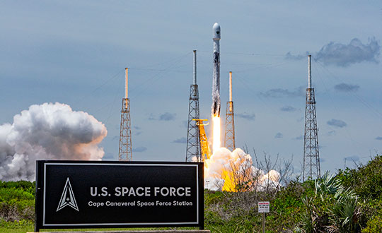
GPS III Space Vehicle 06 (SV06) was launched Jan. 18 from Cape Canaveral Space Force Station in Florida at 7:24 a.m. EST. It is the 18th GPS satellite to broadcast the L5 signal. On Jan. 12, the Space Force Space Systems Command (SSC) had completed encapsulation of SV06 within the Falcon 9 payload.
The launch of SV06 contributed to the SSC’s objective to create resilient GPS, which ensures all users have access to stable positioning, navigation, and timing (PNT) services. SV06, also known as SVN-79, will go through extensive on orbit testing after being introduced into the operational constellation on or about Jan. 25.
Lockheed Martin Space Systems is the main contractor for the GPS III SV06 space vehicle and SpaceX provided launch services. This is Falcon 9’s fifth GPS launch since SpaceX launched GPS III-2 in December 2018.
SV06 is named after the daring pilot Amelia Earhart — the first woman to fly solo across the Atlantic Ocean and to attempt to circumnavigate the world.
The next launch — GPSIII-07 — will take place in 2024.
Constellation Changes. The U.S Space Force Second Space Operations Squadron (2 SOPS) indicates that GPSIII-06, SVN-79/PRN-28, will expand the A2 node in the A plane. It will be identified as position A2F in the vicinity of SVN-52.
SVN-41/PRN-22, forecast unusable until further notice (FCSTUUFN) on Jan. 23, is being set unhealthy and will be used as a test vehicle in AEP.
On Jan. 5, FocalPoint announced an investment from GM Ventures, and collaboration with General Motors (GM), on the integration of next-generation GPS technology in the automotive industry. This collaboration will explore the deployment of electric and autonomous vehicles and aims to apply FocalPoint’s technologies into future vehicles produced by GM to make navigation more precise, especially in urban environments.
Image: FocalPoint
FocalPoint’s Supercorrelation is designed to increase positioning accuracy in urban environments and is highly resilient to spoofing attacks. It will be integrated into GM vehicles to provide more accurate navigation. The goal of the integration is to enhance and expand GM’s Super Cruise, and upcoming Ultra Cruise, hands-free, driving assistance technology.
Supercorrelation is already licensed to u-blox and is in advanced trials with other major manufacturers including Molten Ventures, Greshham House, Passion Capital, IQ Capital, Cambridge Angels and more.