Category: GNSS

  • Directions 2023: Galileo Offers New Services

    Directions 2023: Galileo Offers New Services

    In 2022, the Galileo GNSS continued to provide the world’s most precise satellite navigation information, to a user base that stands at more than 3.5 billion worldwide. Furthermore, provided services continue to improve and expand, with plans for high-accuracy positioning and signal authentication now reaching fruition.

    The European Union Agency for the Space Programme (EUSPA) and the European Space Agency (ESA) continue to enjoy an effective collaboration on the many development, deployment, and evolution activities of the Galileo Programme — each according to their respective responsibilities for service provision and system development with the European Commission (EC) acting as the program manager.

    Photo: Image 1 Directions 2023
    Ranging accuracy performance from January to September 2022.
    image002.Directions2023
    Positioning-related MPLS from January to October 2022.

    New Services Launched in 2022

    Excellent Performance
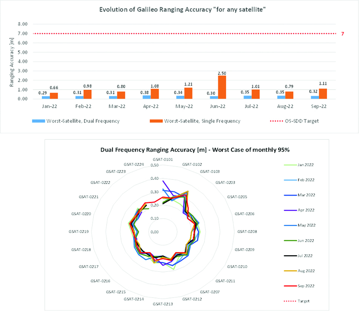
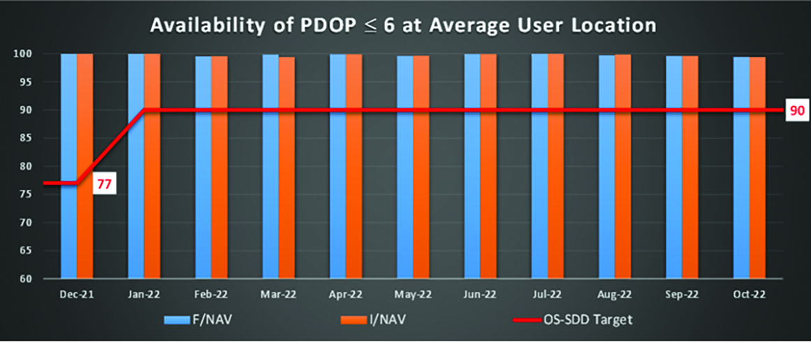
    Service delivery operations and maintenance of operational systems are managed by EUSPA, which supervises many contracts that carry out the day-to-day activities from dedicated control and monitoring centers throughout Europe. In 2022, Galileo timing, navigation, and SAR/Galileo services were delivered with excellent performances that continue to exceed the formal declarations for minimum performance levels (MPL), which were increased in January, both in terms of absolute accuracy and overall service availability. The entry into service of two additional satellites in May and August, have further consolidated the overall service availability to end users.

    image006.Directions2023
    Galileo FOC Batch 3 satellite under testing.

    Expansion of Service Portfolio
    The service provision teams have been able to focus on improvements to, and expansion of, the service portfolio.

    The I/NAV improvement will positively impact end users by enabling a faster time to first fix, and updates to the data validity status flags will lead to better protection of users against expired navigation data. These changes are implemented in updates of the onboard software of the satellites being rolled out across the constellation. At present, seven operational satellites have been successfully updated; the complete software upgrade campaign is planned to be completed this summer.

    Galileo’s new High Accuracy Service will provide free precise point positioning (PPP) corrections, in the Galileo E6-B data component and by terrestrial means, for Galileo and GPS (single and multi-frequency) to achieve real-time user position improved by up to 10 times. The infrastructure to support an initial service (Phase 1) is nearing completion, and the formal declaration of the service capabilities is planned for early this year.

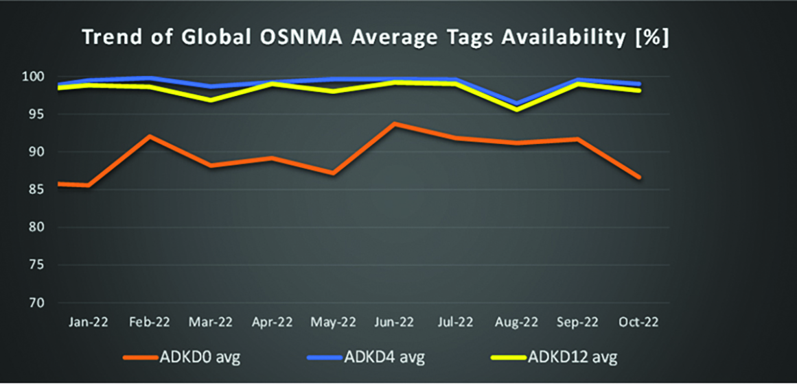
    To provide users with a method of authenticating the received Galileo signals, especially the satellites ephemerides and the Galileo timing parameters, the new Open Service Navigation Message Authentication (OSNMA) service enables a receiver to confirm that a navigation message originated from the EU Galileo infrastructure. Many application areas are expected to benefit from this capability, including smart tachographs, telematics and logistics, UAVs, location-based services, and timing services. Having successfully demonstrated the technology behind the service in 2022, including a public observation phase, the roll-out of the Initial Service is planned to take place by the end of the year.

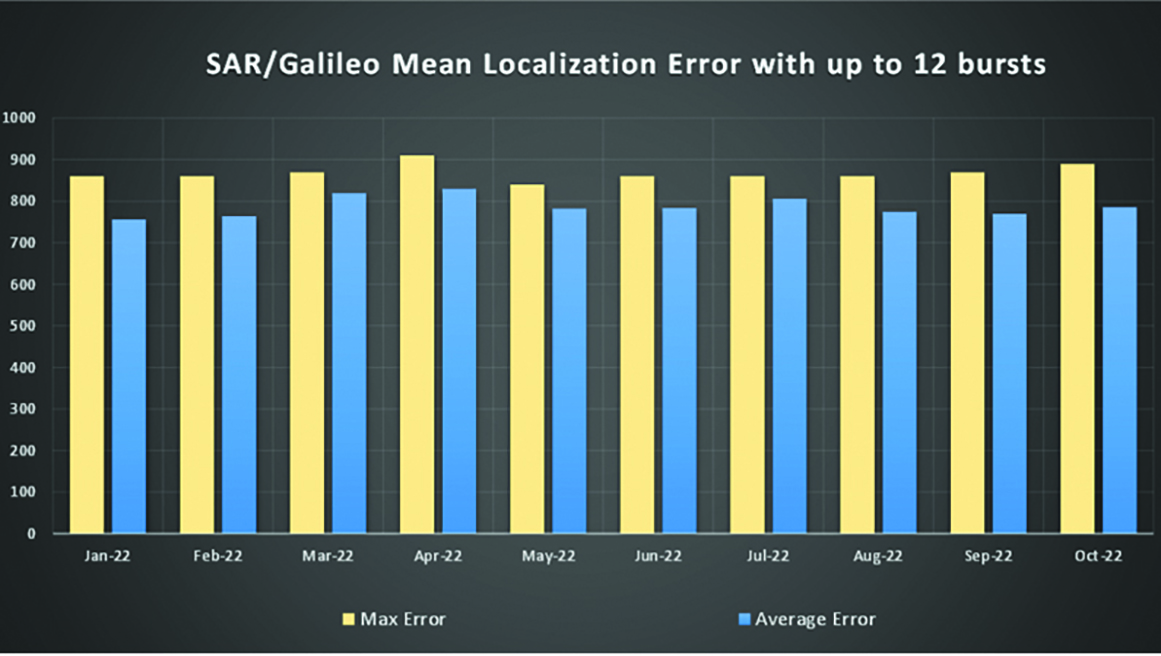
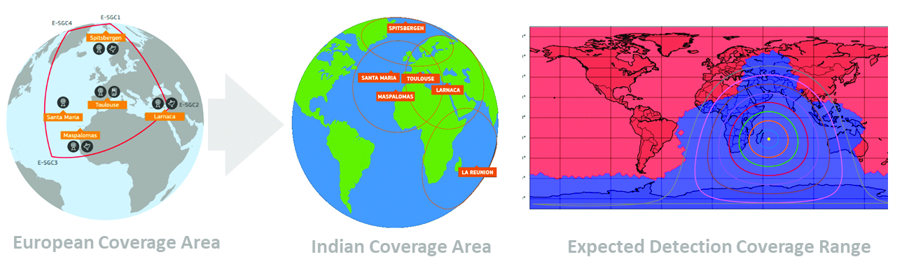
    A fourth Medium Earth Orbit Local User Terminal (MEOLUT) in La Réunion will extend the SAR/Galileo Forward Link Service Coverage Area over the Indian Ocean as part of the SAR/Galileo full operational capability (FOC) declaration expected in the first quarter of 2023. The Cospas-Sarsat commissioning of this new station was completed in September 2022, and operational data is already being distributed to Cospas-Sarsat.

    Reference documents for the above services can be found at the EUSPA European GNSS Service Centre website, including technical notes, interface control documents and service declaration documents.

    SAR/Galileo-related metrics from January to October 2022.
    SAR/Galileo-related metrics from January to October 2022.
    image005.Directions2023
    Extension of the SAR/Galileo Forward Link Service Coverage Area over the Indian Ocean.

    FOC Infrastructure Development Nears Completion

    Satellite Production
    The production of the third batch of Galileo FOC satellites advanced further in 2022 with the completion of the environmental tests and the system compatibility test campaigns at the European Space Agency Test Centre in Noordwijk, The Netherlands. After 10 years of successful testing, on Oct.18, 2022, the last Galileo FOC satellite (flight model number 34) left the test center to return to the premises of the satellite manufacturer, OHB Systems, in Germany. Testing of the remaining 10 satellites has confirmed that they have been correctly built and will perform well in orbit. The acceptance review of the last couple of satellites will take place this summer.
    At the beginning of 2023, the plan is to start in-orbit testing of a quasi-pilot signal on the E5 frequency using the Galileo GSAT201/202 satellites in elliptical orbit. The provision of a signal offering coarse acquisition in Galileo E5-A/GPS L5 can be a distinguishing feature for Galileo with respect to all other constellations to further improve the capability to acquire the E5 signal at low complexity. Following in-orbit testing, the strategy for roll-out of this capability will be assessed with the involvement of receiver manufacturers.

    New SAR Galileo MEOLUT Facility in Réunion island
    New SAR Galileo MEOLUT facility in Réunion island.

    Access to Space
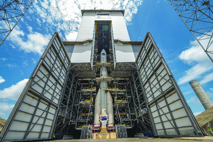
    The discontinuation of Soyuz launch services from the Kourou Space Centre in French Guiana, because of the Russia-Ukraine conflict, has caused delays in the two Galileo launches that had been planned for 2022. The Launch 12 campaign had to be interrupted and in March 2022 the FM25 and 26 satellites were put in storage at the Kourou launch base, then returned to Europe in November.
    Ariane 6 is the baseline launcher for Galileo satellites to ensure European independent access to space. The remaining Batch 3 satellites will be launched with the Ariane 62 launcher vehicle, the two strap-on solid booster variants of Ariane 6, now undergoing the final stages of development led by prime contractor Ariane Group. Ariane 6’s maiden flight is scheduled to take place in the fourth quarter of 2023.

    Ground Segment
    An upgrade of the ground control segment, in charge of command and control of the satellite constellation, is being developed by the industrial consortium led by GMV. The upgrades will address resolution of hardware and software obsolescence including cyber security, operability improvements, and a security monitoring overlay.

    With the planned increase in the number of satellites in orbit, an additional telemetry tracking and control facility (TTCF) is being deployed in Kourou leading to seven operational TTCF stations in early 2023.

    The ground mission segment, in charge of navigation control, is undergoing a complete technological refresh, including hardware/software virtualization performed by an industrial consortium led by Thales France. This upgrade will provide additional robustness, including a system extended contingency mode resilient to outages lasting up to seven days and a new state-of-the-art cyber security monitoring system. It will also provide ranging authentication through encrypted codes on the E6-C signal component for the implementation of the Commercial Authentication Service. Global coverage will be further increased with the introduction of two Galileo sensor stations in Wallis (Pacific Ocean) and Bonaire (Caribbean Sea), for a total of 15 sites around the globe.

    image004.Directions2023
    OSNMA-related metrics from January to October 2022.

    G2G Development Started

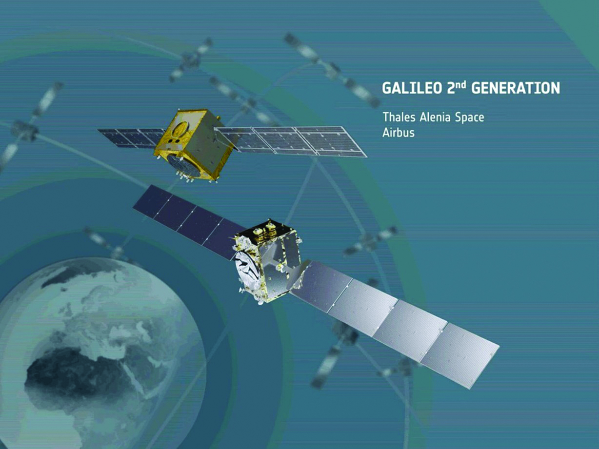
    Galileo’s second generation (G2G) will introduce many innovative technologies to offer unprecedented precision, robustness, and flexibility.
    2022 was a key year for the evolution of G2G activities with the fast development cycles of the first batch of G2 satellites, beginning development of the associated G2G in orbit validation (IOV) ground segment and system test beds, and the consolidation of the G2G final system capabilities — including the coordination of the mission/service roadmaps with the EC, EUSPA, and the EU Member States delegates.

    image007.Directions2023
    Ariane 62 launcher.

    G2G Satellite Manufacturing
    From the satellite development point of view, the two parallel contracts to develop and manufacture each of the six G2G batch one (G2SB1) satellites are progressing in a fast development environment, with the first hardware units ready for integration and testing.
    Following the completion of preliminary design review, these two contracts (for six satellites each) are preparing for unit-level validation/testing, which will lead to the critical design review.

    These satellites will provide the following key innovations:

    • Reconfigurable fully digital navigation payload
    • Point-to-point connection between satellites by inter-satellite-link for command and control, and ranging functionalities
    • Electric propulsion for orbit-raising capabilities
    • Advanced jamming and spoofing protection mechanisms to safeguard.

    The Galileo signals will improve with:

    • On-board authentication capabilities
    • Increased ground-to-space data rate
    • Improved time reference (number of clocks and advanced clock monitoring functions).

    G2G IOV Procurements
    2022 was also the year in which two key events took place with respect to G2G in-orbit validation (IOV) ground segment and system test bed procurements:

    • Finalization of the procurement cycle, now in the final evaluation/award phase, to be kicked off in the first quarter of this year
    • Confirmation of the IOV design through different coordinated actions with the EC and EUSPA, including the G2 system preliminary design review.
    • The contracts will provide Europe with the following capabilities:
    • G2SB1 satellite launch and early orbit phase, in-orbit testing and enhanced legacy services provision
    • G2 new capabilities in-orbit validation, including prototyping and validation of all the novel technologies that can exploit the full capabilities of the G2SB1 satellites.

    Eleven contracts will be issued to manage in synchrony all the G1 and G2 assets for the coming years:

    • G2 IOV ground control segment (G2 GCS) for satellites monitoring and control
    • G2 IOV ground mission segment/secured facility (G2 GMS-GSF) for the production, dissemination and monitoring of all enhanced legacy services and the dissemination of new G2 advanced capabilities for validation
    • G2 IOV security monitoring (G2 SECMON), for the cyber/security monitoring of the system
    • G2 filling device (G2 FD), to ensure proper initialization of system assets
    • G2 system test bed (G2STB), to generate and monitor new G2 capabilities for validation of the G2G mission/services
    • G2 PRS test bed (G2PRSTB), similar to G2 system test bed but focused on advanced PRS capabilities for validation purposes
    • G2 security chain (G2SC), a test bed to ensure proper satellite-ground segment qualification before launch
    • Four system engineering support contracts (G2 SETA), where the main GNSS technical experts from different industries in Europe provide their support to ESA and EUSPA in their different fields of expertise.
    • These contracts are complemented by a significant set of system research and development and test tools, such as test user receivers and radio frequency constellation simulators.
    Photo:
    G2G batch number one (G2SB1) satellites.

    Galileo Second Generation System PDR
    The Galileo Programme is not only focusing on short-term G2G development activities, but also looking forward to the future in terms of the consolidation and definition of G2G final operation capabilities. During the second half of 2022, more than 200 public representatives from the EC, EUSPA, ESA and Member States held countless meetings in the frame of the G2G system preliminary design review, which concluded in early December 2022.

    As part of this review, the long-term implementation (G2G in orbit capability, or IOC, and final operational capability, or FOC) was reviewed and an agreement was reached on future steps. The evolution of Galileo capabilities will not only provide better services through advanced technical solutions, but will also ensure continuity of service and enhanced backward compatibility for first-generation legacy users.

    Conclusions
    The efforts of ESA and EUSPA continue with the aim of providing users continuous and stable services and evolving space and ground infrastructure to maintain Galileo competitiveness with the other global navigation satellite systems.


    For analogous updates on the other three GNSS constellations, please see:

  • Directions 2023: BDS Development Continues Apace

    Directions 2023: BDS Development Continues Apace

    In 2022, the BeiDou Navigation Satellite System (BDS) continued to improve its service performance, expand global applications, and deepen and promote international cooperation.

    On Nov. 4, 2022, a white paper titled “China’s BeiDou Navigation Satellite System in the New Era” was published. The paper shows the continuous, stable and reliable operational capability of BDS, its applications achievements across the industries, international development with openness and integration, and unremitting pursuit of helping to build a community with a shared future for humanity and a better world.

    System Services Performances

    In orbit are 45 BDS operational satellites, including 15 BDS-2 satellites and 30 BDS-3 satellites. Figure 1 shows the number of visible BDS satellites worldwide as of BDT 06:00 on Dec. 6, 2022.

    Picture1.Directions2023
    Figure 1. Number of visible BDS satellites. (Image: www.csno-tarc.cn)

    BDS has reached a continuity of 99.996% and an availability of 99%. The innovative constellation involves inter-satellite links, signal system optimization, intelligent operation and maintenance, software reconstruction and upgrading of in-orbit satellites, and global test and assessment.
    As measured by the International GNSS Monitoring and Assessment System (iGMAS), the BDS global positioning accuracy is less than 1.5 m horizontally and 2.5 m vertically (95% confidence) — better than the nominal service performance parameters.

    So far, the measured signal power spectrum envelope of the BDS satellites remains consistent with the superior signal quality; the signal-in-space accuracy of any BDS satellite is better than 4.6 m. The time offset between BDT and UTC (NTSC) remains within 26 ns.

    The BDS Coordination Framework has maintained consistency with the International Terrestrial Reference Frame 2014, and the accuracy is better than 3 cm. The orbital accuracy of the broadcast ephemeris of the BDS-3 medium Earth orbit (MEO) satellite is better than 0.5 m, and the clock offset of the broadcast ephemeris of the BDS-3 satellites is better than 5 ns.

    BDS concentrates on construction of the application infrastructure and has established four major characteristic service platforms:

    • Short Message Communication Service
    • Satellite-based Augmentation System Service
    • Search-and-Rescue Service
    • Ground Based Augmentation System Service.

    These platforms will expand and upgrade the applications and provide more efficient and convenient services for users.

    The BDS Short Message Communication Service platform realizes the interconnection with ground mobile communication systems and networks, and integrates the BDS short message communication functionality into smartphones without the need to change the SIM card or contact number.

    For the BDS Satellite-based Augmentation System Service platform, the system’s ground segment includes 30 monitoring stations and two data processing centers. The system will provide single frequency (SF) and dual-frequency multi-constellation (DFMC) services through GEO satellites. The Civil Aviation Administration of China has initiated and organized the technical testing and certification of SF service before applications.

    The BDS Search-and-Rescue Service provides users with distress alert information access and distribution, as well as return link services. It is currently at the initial operational stage with sound performances. The operational status of the BDS SAR payload has been submitted to Cospas-Sarsat.

    The BDS Ground-Based Augmentation System Service platform’s real-time positioning accuracy can reach 2 cm horizontally and 5 cm vertically. The post-processing accuracy can reach 2 mm horizontally and 5 mm vertically. At present, the BDS ground-based augmentation network has provided the A-BDS positioning and the BDS high-precision services for more than 1.5 billion users in more than 230 countries and regions, with services delivered 2 trillion times in total, equivalent to nearly 3 billion on average per day. BDS has provided high-precision positioning services for more than 20 million mobile phones in the country.

    The BDS Applications Industry

    The BDS applications industry has achieved sustainable development. In 2021, the total output of China’s satellite navigation and location-based service industry reached about 469 billion yuan (about 67.4 billion U.S. dollars), with a compound annual growth rate of more than 20%. A complete industrial chain covering chips, modules, antennas, boards, terminals and services has been established.

    Industrial applications. BDS has been fully applied in various industries — including transportation, agriculture, forestry and fishery, public security, disaster mitigation and relief — and has been integrated into infrastructure such as electric power, water conservation, finance and communications.

    As BDS applications fields expand, its in-depth applications have been growing as well. As of June 2022, more than 8 million BDS terminals had been installed in the transportation sector. More than 1.3 million terminals were used in the farming, forestry, livestock and fishing industries, and more than 1.8 million terminals were adopted by public security agencies. Large-scale BDS applications have been advanced in communication and timing services, meteorological monitoring, emergency response and disaster mitigation, and urban management. In emerging applications sectors, BDS has served epidemic prevention and control, telemedicine, caring for seniors, promoting the realization of intelligent health services that serve everyone, and accelerating intelligence and modernization in related fields.

    Mass market applications. BDS has been widely used in mass market applications, such as mobile phones and wearable devices. In the first half of 2022, among all types of smartphones that applied for network access in China, 128 supported the BDS-based positioning function. More than 130 million smartphones supporting BDS services were shipped, accounting for more than 98% of the country’s total volume. The BDS positioning service is used more than 100 billion times daily on average for a platform that supports mobile map navigation. In particular, mobile phones have been fitted with high-precision positioning services. Lane-level navigation has been implemented in eight cities in China, including Shenzhen, Chongqing and Tianjin. The first mobile phone in the world that supports BDS-3 regional short message communication services has been officially released, enabling users to send short messages through BDS.

    BDS international applications. BDS has been applied in more than half the countries and regions in the world, with more diversified application modes and application fields.

    BDS products, technologies and services have been recognized by more international users:

    • In Mozambique, BDS-based UAVs have greatly improved the efficiency of plant protection operations
    • In Lebanon, BDS-based high-precision technology has been successfully applied to the construction and measurement of the port of Beirut
    • In Burkina Faso, BDS supported surveying and mapping during the construction of hospitals to prevent and control local infectious diseases, such as COVID-19
    • In Saudi Arabia, BDS is widely used in fields such as surveying and the collection of geographic information, the construction of urban and municipal infrastructure, and the positioning of personnel or vehicles in deserts
    • In Asia, BDS-based high-precision positioning services are contributing to the monitoring of Sarez Lake Dam in Tajikistan, the completion of the China-Kyrgyzstan-Uzbekistan Highway, the China-Kazakhstan crude oil pipeline, and the routine operation of China-Europe Railway Express.

    International Cooperation

    Following the principles of openness, cooperation and resource sharing, BDS has been actively carrying out practical international cooperation and exchanges as well as facilitating the development of global satellite navigation.

    Multilateral cooperation. BDS representatives continue to participate in international activities under the framework of the United Nations International Committee on GNSS and other multilateral forums, to advocate joint development of global satellite navigation by contributing Chinese wisdom and proposals. BDS has also participated in international academic conferences in the field of satellite navigation, such as the Institute of Navigation meetings, the Munich Satellite Navigation Summit, and the Multi-GNSS Asia Conference.

    Bilateral cooperation. The Ninth Meeting of the China-Russia Project Committee on Major Strategic Cooperation in Satellite Navigation was successfully held in September 2022. Under the framework of the Committee, BDS and GLONASS have carried out continuous cooperation in such areas as compatibility and interoperability, system performance testing and assessment, and joint applications. China’s Satellite Navigation Office signed cooperation documents in the field of satellite navigation with partners from the United Arab Emirates and the Arab Civil Aviation Organization, to carry out extensive cooperation and continue to deepen cooperation with Pakistan, Iraq, Thailand, Argentina, South Africa and other countries.

    International Standards. BDS is increasingly recognized by international organizations such as the International Maritime Organization (IMO), the International Civil Aviation Organization (ICAO), Cospas-Sarsat, IEC, 3GPP and RTCM. In November 2022, the BDS Message Service System (BDMSS) was ratified by the Global Maritime Distress and Safety System (GMDSS), making BDMSS the third GMDSS satellite communication system recognized by the IMO. The Declaration of Intent for Cospas-Sarsat MEOSAR Cooperation was signed between the cooperating agencies (from Canada, France, Russia, and the United States) of the International Cospas-Sarsat Program and the Maritime Safety Administration of China, meaning China formally becomes the provider of the Cospas-Sarsat space segment.

    The Future

    In the future, BDS will launch back-up satellites to ensure better performance by upgrading the constellation’s availability. While maintaining stable operation, BDS will speed up in combination with new technologies such as 5G, artificial intelligence and Big Data to build a more ubiquitous, more integrated, and more intelligent national comprehensive PNT system by 2035. BDS will continuously adhere to the development concept that “BDS is developed by China, dedicated to the world and aiming to be world class,” promote system development and make contributions to social development and construction of the community with a shared future for mankind.


    For analogous updates on the other three GNSS constellations, please see:

  • Directions 2023: GLONASS Renews Its Constellation

    Directions 2023: GLONASS Renews Its Constellation

    On Nov. 29, 2022, Russia launched the 51st Glonass-M satellite, completing a 20-year history that began on Dec. 10, 2003, with the launch of the first one. These satellites have been providing navigation signals in two frequency bands, L1OF and L2OF, to civil users since 2011.The average orbit lifetime for this type of satellite is more than 10 years, and 13 Glonass-M satellites operate beyond their guaranteed lifetime. The last set of seven satellites has been broadcasting the first CDMA civil signal, L3OC, by means of an additional antenna and onboard transmitter.

    Starting this year, the constellation will be renewed by Glonass-K and Glonass-K2 satellites, which provide CDMA signals to users. Furthermore, four Glonass-K satellites will be supplemented with additional Glonass-K satellites and the first Glonass-K2 satellite. The K2 satellite has passed all ground tests and is ready to be transported to the launch site (Figure 1). Table 1 lists the technical characteristics of GLONASS satellites.

    GLONASS image001
    Figure 1. Artist’s rendition of the Glonass-K2 satellite in orbit.
    Table 1. The evolutions of GLONASS satellites.
    Table 1. The evolutions of GLONASS satellites.

    The distinguishing feature of this satellite’s design is its two antenna arrays — one for CDMA signals with phase centers on the geometrical axis of the satellite, and the second for FDMA signals with phase centers shifted by 0.9 m relative to that axis.

    The optical reflector panel center is also located on the satellite’s geometrical axis and passed through its mass center. It seems to be a very interesting scientific task to estimate the satellite flight model parameters by International Laser Ranging Service stations with the objective to improve the accuracy of the navigation signals for both antenna arrays.

    Future GLONASS satellites will have a single antenna array for CDMA and FDMA signals (see Figure 2).

    GLONASS image002
    Figure 2. The evaluations of GLONASS satellites.

    For analogous updates on the other three GNSS constellations, please see:

  • EUSPA releases updated OSNMA documents

    EUSPA releases updated OSNMA documents

    EUSPA logoThe European Union Agency for the Space Programme (EUSPA) along with the European Commission, have published guidelines that specify the baseline applicable to the Galileo Open Service Navigation Message Authentication (OSNMA) receiver service provision phase. The new documents include the OSNMA Signal-in-Space (SIS) Interface Control Document (ICD), and OSNMA Receiver Guidelines.

    The OSNMA SIS ICD specifies, among other things, the interface between the Galileo Space Segment and the Galileo User Segment. This document is an addition to the Galileo Open Service (OS) SIS ICD.

    The OSNMA Receiver Guidelines provide generic instructions for the user segment implementation of the OSNMA functionality and complement the OSNMA SIS ICD. Additionally, the guidelines explain user capabilities and steps to implement to verify the authenticity of the Galileo navigation message.

    Both documents will be used for the upcoming OSNMA Service Provision Phase that will begin after the OSNMA Service Declaration. They have been developed as an evolution of the Galileo OSNMA User ICD for test phase (v1.0) and the Galileo OSNMA Receiver Guidelines for test phase (v1.1). Copies of the documents can be found here.

  • Last first-generation Galileo satellite leaves test site

    Photo:
    Image: ESA

    On Nov. 11, the last Galileo satellite of first-generation series was shipped from ESA’s ESTEC Test Centre, Europe’s largest satellite testing facility. Galileo is Europe’s largest satellite constellation and one of the most accurate satnav systems in the world.

    Galileo’s development began two decades ago with two test GIOVE satellites, followed by a series of other operational launches to add to the constellation. The current constellation consists of 34 Full Operational Capability satellites, the initial two GIOVE satellites, and the Galileo In-Orbit Validation satellite. Galileo Second Generation satellites are already in development.

  • Copernicus Sentinel-3 and Sentinel-6 GNSS orbital products available

    Copernicus Sentinel-3 and Sentinel-6 GNSS orbital products available

    Artist's depiction of the Copernicus Sentinel-6 satellite, launched in November 2020. (Image: ESA)
    Artist’s depiction of the Copernicus Sentinel-6 satellite, launched in November 2020. (Image: ESA)

    The Copernicus Precise Orbit Determination (CPOD) Service, in charge of computing precise orbits for the Copernicus Sentinel-1, -2, -3 and -6 missions,  routinely publishes GNSS and quaternions data and precise orbital products of these missions on the POD Data Hub of the Copernicus Open Access Hub.

    The following products are published:

    1. Sentinel-1, 2, 3 A&B GNSS RINEX observation files (AUX_GNSSRD)
    2. Sentinel-1, 2, 3 A&B Quaternions files (AUX_PROQUA)
    3. Sentinel-1 A&B CPOD Predicted Orbits (AUX_PREORB)
    4. Sentinel-1 A&B CPOD Restituted Orbits (AUX_RESORB)
    5. Sentinel-1 A&B CPOD Precise Orbits (AUX_POEORB)
    6. Sentinel-3 A&B CPOD Restituted Orbits (SR___ROE_AX)
    7. Sentinel-3 A&B CPOD Medium Orbit (AUX_RESORB)
    8. Sentinel-3 A&B CPOD Precise Orbits (AUX_POEORB)
    9. Sentinel-3 A&B CPOD Precise Platform data (AUX_PRCPTF)

    The following new products from Sentinel-3 and Sentinel-6 are now available as well. The Sentinel-6A GNSS RINEX observations include GPS and Galileo data — the first publicly available Galileo data obtained from an orbiting receiver.

    1. Sentinel-3A&B CNES Medium Orbit Ephemeris (SR___MDO_AX)
    2. Sentinel-3A&B CNES Precise Orbit Ephemeris (SR___POE_AX)
    3. Sentinel-6A CNES Medium Orbit Ephemeris (AX____MOED_AX)
    4. Sentinel-6A CNES Precise Orbit Ephemeris (AX____POE__AX)
    5. Sentinel-6A CPOD Restituted Orbit Ephemeris (AX____ROE__AX)
    6. Sentinel-6A GNSS RINEX observation files (AUX_GNSSRD)
    7. Sentinel-6A Quaternions files (AUX_PROQUA)

    The GNSS RINEX (AUX_GNSSRD) and Quaternions files (AUX_PROQUA), together with the final orbital products (AUX_POEORB, AUX_PRCPTF, SR___POE_AX, and AX____POE__AX) are available at the beginning of each mission.

    The other orbital products (AUX_RESORB, SR___ROE_AX, SR___MDO_AX, AX____MOED_AX, and AX____ROE__AX) are available for at least one month, until the final products are available.

    The typical accuracy of the orbital products can be found in the Regular Service Reviews carried out by the CPOD Service quarterly.

    Details about these products can be found in the POD Product Handbook.

    Auxiliary data needed for precise orbit determination, such as maneuvering information, can be found in the Sentinel online:

    Please send questions to mailto:[email protected].

  • Ukraine attacks changed Russian GPS jamming

    Ukraine attacks changed Russian GPS jamming

    Two Russian airbases deep inside the country were attacked on December 5: the Engels-2 base in the Saratov region and Dyagilevo near Ryazan. The next day an oil tank at the Kursk airfield closer to the border with Ukraine was hit and set on fire.

    Reports from Russian witnesses and unofficial sources in Ukraine indicate that the attacks were carried out with UAVs operated by the Ukrainian military.

    The Russian government has long interfered with reception of GPS signals, especially near and within its own borders. The early December attacks seem to have motivated an increase in this activity.

    More Interference

    Information displayed by the website GPSJam.org indicates that, on the first day of the attacks, GPS interference was detected around Moscow, at two airbases to the east, and near the Engels-2 airbase.

    Photo:
    Image: RNT Foundation

    GPSJam.org uses anomalies in crowdsourced aviation ADS-B data as an indicator of unreliable GPS signals. Note that no such information is available for much of Ukraine as commercial aircraft have been avoiding the airspace since the beginning of the current conflict.

    The GPSJam.org depiction of the region six days after the attacks is quite different and has stayed much the same ever since. It seems to show greatly increased interference in the vicinity of the Engles-2 airbase, and new interference around the Marinikova airbase to the south along the Volga River.

    Photo:
    Image: GPSJam.org

    A History of Jamming and Spoofing

    The Russian government has been deliberately and systematically interfering with GPS signals in some places since at least 2016.

    An article in the Moscow Times that year bragged “The Kremlin Eats GPS for Breakfast.”

    The article documented a tech podcaster’s discovery that GPS L2 and L5 signals were being jammed and GPS L1 was being spoofed in the vicinity of the Kremlin. The combination of jamming and spoofing caused receivers in the area to report that, rather than being downtown, they were at the Vnukovo international airport some 20 kilometers away.

    The author of the article speculated the spoofing was to protect government officials and buildings from surveillance and attack by UAVs. Since 2013 most larger UAVs have been programmed by manufacturers with the locations of airports and to avoid them. Making UAVs near the Kremlin believe they were at an airport could be an effective part of an overall defense system by causing them to avoid the area.

    In 2017 the Resilient Navigation and Timing Foundation examined maritime AIS data and found similar spoofing activity had been occurring in the Black Sea for at least two years. A 2019 report by the nonprofit C4ADS expanded upon this work and revealed spoofing activity at various times and places across Russia. Almost 10,000 instances were documented across ten locations between 2016 and 2018. The report also linked much of the spoofing to the Russian Federal Protective Service and movements of senior government officials. This reinforced the idea that the spoofing was part of VIP protection efforts.

    Questions Abound

    It is easy to conclude that Russia’s recent increases in interference activity were in reaction to the UAV attacks on December 5 and 6.

    Western intelligence and military officials may be arriving at additional conclusions and asking themselves some intriguing questions. One might be why it took six days after the first UAV attack to implement the new interference scheme. The report by C4ADS made it clear that Russian equipment used for wide area spoofing is quite portable.

    Perhaps the delay was one of decision making. Some observers have commented that much of the direction for the current conflict comes directly from the top, rather than being delegated to field commanders. It could well be that it took that long for the Kremlin to realize that UAVs were involved and direct equipment to be deployed.

    Another question likely being asked is about the selection of locations where interference is being used. Interference activity was observed at the Engels-2 airbase before it was attacked. This seems to have greatly increased after the attack. Airfields at Dyagilevo and Kursk were also attacked, but no interference activity has been observed at either location.

    At the same time, substantial new interference activity has been observed at the Marinikova airbase, which was not attacked. There are likely several contributing factors to why some locations have been protected with jamming and/or spoofing and some not.

    While Russian forces have a fearsome reputation for electronic warfare and their ability to interfere with GPS signals, the amount of equipment and the number of trained operators may be limited. C4ADS’ finding that spoofing equipment was moved around with VIPs rather than permanently located around the nation could indicate a limited amount.

    This would mean that the bases and facilities to be protected must be prioritized. The lack of interference around Kursk and Dyagilevo could mean Russia sees them as less important, or less likely to be attacked again. New interference at Marinikova could mean it is a high value target and in need of protection.

    Conversely, some of the new activity could be designed to deceive and draw Ukrainian fire away from higher value targets and toward lower ones. Such is the potential nature of military strategy in war.

    Analysts are also probably asking questions about the effectiveness of jamming and spoofing as a defense against a determined UAV-operating opponent.

    Interference had been detected at Engels-2 before it was successfully attacked by one or more UAVs. This likely shows that Ukrainian forces disabled any geofencing that might have been originally included as part of the UAVs’ original design. They may have also upgraded the UAVs’ navigation receivers with hardware or software to make them much more resistant to interference from the ground.

    Navigation Warfare Increasingly Important

    Regardless, the UAV attacks and observed changes in interference activity reaffirm the importance of navigation warfare in modern conflicts. Knowing the location of your forces and of your targets has always been important. In an era of precision strike and autonomous systems, robust and resilient navigation that resists or overcomes interference is even more important.

    The U.S. military has long recognized this, establishing its Joint Navigation Warfare Center in 2004. The center focuses on the intersection of positioning, navigation, and timing with electronic warfare and cyber operations. Undoubtedly Russia has identical concerns and probably an equivalent organization.

    The current conflict in Ukraine will continue to raise questions for both sides. Not in question, though, is the importance of navigation warfare to this conflict, and that it will be increasingly important in future ones.

  • Space Force enhances GPS ground communications for greater resiliency

    Space Force enhances GPS ground communications for greater resiliency

    Modernized communications lines were installed at seven locations worldwide in an overhaul of the global communications network that provides command and control of the GPS constellation.

    Kwajalein Atoll in the Marshall Islands is one of seven locations that received a GPS communications network overhaul.(Photo: USGS)
    Kwajalein Atoll in the Marshall Islands is one of seven locations that received a GPS communications network overhaul.(Photo: USGS)

    From 2018 to 2022, GPS Product Support Delta — in conjunction with the Defense Information Systems Agency (DISA) — performed a complete overhaul of the global communications network required to provide command and control of the GPS satellite constellation. GPS Product Support Delta is under Space Systems Command of the U.S. Space Force.

    The project, called GPS Operations Network Enhancements (GONE), connected multi-protocol label switching internet protocol (IP)-based routers to modernized communications lines at seven key GPS facilities, replacing older serial lines.


    “With the GONE project completed, we are seeing a 75 percent reduction in communication line interruptions.”


    The GONE initiative “has significantly enhanced communications for GPS weapon systems,” said Brian Botka, Product Support Delta GPS program manager.

    “These upgrades not only increase communications speed and reduce overall down-time and adding a new paradigm in network resiliency with the networks capable of recovering in mere seconds from an outage or issue,” said Sean Foley, DISA technical project manager. “The system upgrades will continue to improve service to the warfighter as well as enable increased resiliency and network diversity for DISA.”

    The modernized communications lines were installed at

    • Schriever Space Force Base, Colorado
    • Vandenberg SFB, California
    • Cape Canaveral Space Force Station, Florida
    • Facilities in Hawaii, Ascension Island, Diego Garcia and Kwajalein Atoll.

    Throughout the COVID-19 pandemic, many of these locations were under strict lockdown or required long quarantine periods, making coordination and travel to remote locations more challenging.

    Lockheed Martin was the contractor who supported Product Support Delta GPS on the GONE project. “This was a collaborative effort with Product Support Delta GPS and DISA that required significant logistical efforts due to the COVID-19 pandemic,” said Christina Mancinelli, Lockheed Martin GPS Ground Programs director.

    “With the GONE project completed, we are seeing a 75 percent reduction in communication line interruptions, and we expect that metric to continue to improve,” Mancinelli said. “The migration of the GPS communication lines to the modern MPLS [multiprotocol label switching] routers and Ethernet-based connections continues the significant improvements in GPS ground capability, cybersecurity and reliability.”

    SSC is the USSF field command responsible for rapidly identifying, prototyping, and fielding resilient space capabilities for joint warfighters. It delivers sustainable joint space warfighting capabilities to defend the nation and its allies while disrupting adversaries in the contested space domain.

    SSC mission areas include launch acquisition and operations; space domain awareness; positioning, navigation, and timing; missile warning; satellite communication; and cross-mission ground, command and control and data.

  • Experts urge jamming detection network – Free webinar shows easy method using smartphones

    Experts urge jamming detection network – Free webinar shows easy method using smartphones

    By all accounts, it is getting worse. Hundreds of internet sites sell inexpensive devices to interfere with GPS and other GNSS signals. Estimates place the number of devices extant in the United States in the tens of thousands or more. Studies show accidental interference happens about ten times more often than deliberate jamming.

    In January a high-power signal in the Denver area impacted GPS reception across 4,000 square miles of airspace. The source was located, and the signal terminated after 33 hours.

    October saw a similar event near Dallas that lasted for 44 hours before it ended on its own. The source of that signal was never identified.

    The United States spends more than $2 billion a year to operate, maintain, and refresh GPS. Its positioning, navigation, and timing (PNT) services underpin virtually every technology, every facet of the economy. Yet, as was dramatically demonstrated at least twice this year, the nation does not have the ability to quickly characterize, locate and mitigate even the most powerful jamming signals.

    The President’s National Space-based Positioning, Navigation, and Timing Advisory Board is a panel of GPS and navigation policy experts that meets twice a year to advise the government on such issues. In November, they recommended that the government establish a “National GNSS interference detection and reporting network based on mobile wireless technology.


    Photo:
    National Space-based PNT Advisory Board, November 2022 Image: NASA

    The board made a similar recommendation in 2018 as a part of a more comprehensive discussion of actions the nation should take to protect GPS signals and users.

    The group’s most recent recommendation is to implement a detection network based on crowdsourcing and smart phones. This would be done in collaboration with wireless service carriers.

    Photo:
    Image: Page 17  gps.gov

    Yet cooperation of wireless carriers, while helpful, may not be necessary, according to at least some experts.

    Dr. Dennis Akos of the University of Colorado has developed an app for Android smart phones that enables devices to detect and automatically report interference with GPS and other GNSS signals. The app uses four detection methods based on location data already used by Android devices. These are comparing GNSS and network locations, checking the Android mock location flag, comparing the GNSS and Android system times, and observing the automatic gain control (AGC) and carrier-to-noise density (C/N0) signal metrics.

    Akos recently presented his work at an Institute of Navigation (ION) webinar. Video of the webinar is posted on YouTube. His paper can also be downloaded for free from the ION website.

    Commenting on Akos’ work, GNSS expert Logan Scott suggests that the U.S. government could use this new capability to establish the first phase of a national GPS/GNSS interference detection network with very little cost or effort.

    “The US government provides managed phones to many government employees,” he said. “Having an app like Dennis’s operating on an opportunistic basis, [only when GPS is on in the phone] would give access to millions of phones as observers. Bottom line, the US could stand up a national observation network on an accelerated timeline, understand the nature of the threat, and avoid the embarrassments of [events such as those that occurred at] DIA [Denver International Airport] and DFW [Dallas Fort Worth airport]. And it would not cost much.”

    If an effective system of some sort is not implemented, American lives and property will be at continued and increasing risk. In the words of the Advisory Board recommendation:

    Photo:
    Dr. Dennis Akos. Image from University of Colorado’s website.

    “Without a reliable, automated means of detecting and locating sources of GNSS interference, space-based PNT applications, and the general U.S. public, will continue to be plagued by potentially life-threatening and/or costly service disruptions that take days or weeks to resolve.”

  • 2023 European Navigation Conference scheduled for May/June

    2023 European Navigation Conference scheduled for May/June

    The 2023 European Navigation Conference (ENC) will take place May 31-June 2 with a focus on resilient navigation. This conference, which will welcome professionals from the positioning, navigation, and timing (PNT) field, is organized by the Netherlands Institute of Navigation, a member of the European Group of Institutes of Navigation (EUGIN).

    Given the growing vulnerability of satellite-based position and timing, the conference will focus on resiliency, which requires redundancy in the signal domain, terrestrial and space infrastructures, and on-board implementation — as well as addressing vulnerabilities in navigation functions, data, and guidance control.

    Thanks to the hospitality of the European Space Agency, the ENC will be held at the ESTEC site in Noordwijk, The Netherlands, where the Galileo satellite system is designed and where navigation satellites are tested before launching.

    Photo: extravagantni/iStock/Getty Images Plus/Getty Images
    Photo: extravagantni/iStock/Getty Images Plus/Getty Images
  • Spirent to host two federal training seminars in 2023

    Spirent to host two federal training seminars in 2023

    Photo:
    Image: Spirent

    Spirent plans to host two seminars in early 2023 where experts will share PNT developments and provide training on Spirent’s products. Registration for the seminars is free and includes a two-week software license that can be downloaded to provide hands-on training.

    Seminar training topics includes fundamentals of GPS/GNSS testing, how to create realistic testing scenarios, GPS/GNSS vulnerabilities like jamming and spoofing, vulnerability mitigation and more.

    One session will be held in Huntsville, Alabama, March 8-9 and the other in Los Angeles, California, March 14-15. While registration is free, seats at both seminars are limited.

    To register for Spirent’s seminars, click here.

  • Satellite observation is helping to map lava from Hawaii’s Mauna Loa volcano

    Satellite observation is helping to map lava from Hawaii’s Mauna Loa volcano

    Image: USGS
    Image: USGS

    In late November, the Mauna Loa volcano in Hawaii erupted for the first time since 1984 and is currently in an active volcanic eruption. Scientists are using satellites and helicopters to record and map the flow of lava on the Big Island.

    The active eruption is in a remote area on the island, making it difficult to map it and the lava flow. It is critical to have accurate emergency information during the eruption in order to have appropriate resources and have ample time to evacuate, if necessary.

    The easiest and most accurate way to map the lava from this eruption is via satellite. Based on satellite observation, scientists have been able to create a mobile app to support helicopter crews in making maps of lava flow that update in real time. This real time evaluation is sent to emergency personnel and geologists tracking the eruption patterns.


    Photo:
    Image: USGS

    Mauna Loa has erupted 33 times, the most recent of which was 38 years ago. The volcano typically averages an eruption every 5 years, making Mauna Loa’s most recent dormant period longer than normal. According to the U.S. Geological Survey (USGS), this eruption was caused by an increase in earthquakes below the Mauna Loa Summit, an increase of inflation tracked by GPS stations, and several additional geologic factors.

    Live footage of the Mauna Loa eruption can be seen here.