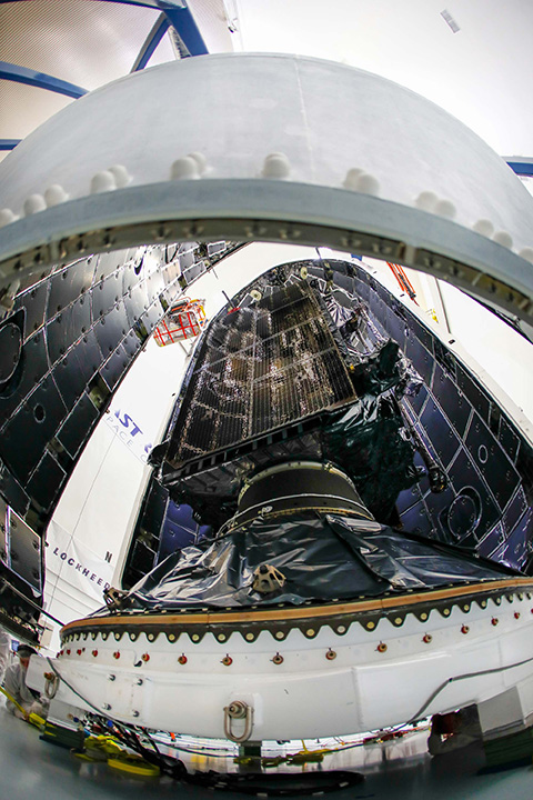
GPS III SV01 is now encapsulated and will be placed on the SpaceX rocket for Dec. 18 launch. (Photo: Lockheed Martin)
The U.S. Air Force’s first Lockheed Martin-built GPS III satellite is now encapsulated for its planned Dec. 18 launch from Cape Canaveral Air Force Station, Florida, on a SpaceX Falcon 9 rocket.
GPS III Space Vehicle 01 (GPS III SV01) underwent pre-launch processing, fueling and encapsulation at Astrotech Space Operations in Titusville, Florida. During encapsulation, GPS III SV01 was sealed in its launch fairing — an aerodynamic, nose-cone shell that protects the satellite during launch.
In the coming days, the fairing-enclosed satellite will be mounted to the rocket as launch preparations continue.
GPS III SV01 is the first of an entirely new design of GPS satellite that will help the Air Force modernize today’s GPS constellation with new technology and advanced capabilities.
GPS III has three times better accuracy and up to eight times improved anti-jamming capabilities. Spacecraft life will extend to 15 years, 25 percent longer than any of the GPS satellites on-orbit today. GPS III’s new L1C civil signal also will make it the first GPS satellite broadcasting a compatible signal with other international global navigation satellite systems, like Galileo, improving connectivity for civilian users.
“The world is dependent on GPS. More than four billion military, commercial and civilian users connect with signals generated by GPS satellites every day,” said Johnathon Caldwell, Lockheed Martin’s vice president for Navigation Systems. “The launch of GPS III SV01 will be the first step in modernizing the Air Force’s GPS constellation with the most powerful and resilient GPS satellites ever designed and built.”
Lockheed Martin developed GPS III and manufactured GPS III SV01 at its advanced $128-million GPS III Processing Facility near Denver. In September 2017, the Air Force declared the satellite “Available for Launch” (AFL) and had the company place it into storage.
In 2017, the Air Force “called up” the satellite for launch and Lockheed Martin delivered it to Florida on Aug. 20. The Air Force nicknamed the satellite “Vespucci” after Italian explorer Amerigo Vespucci.
GPS III SV01 is the first of 10 GPS III satellites originally ordered by the Air Force. GPS III SV03-08 are now in various stages of assembly and test. In August, the Air Force declared the second GPS III “AFL” and, in November, called GPS III SV02 up for 2019 launch.
In September, the Air Force selected Lockheed Martin for the GPS III Follow On (GPS IIIF) program, an estimated $7.2 billion opportunity to build up to 22 additional GPS IIIF satellites with additional capabilities.
GPS IIIF builds off Lockheed Martin’s existing modular GPS III, which was designed to evolve with new technology and changing mission needs. On Sept. 26, the Air Force awarded Lockheed Martin a $1.4 billion contract for support to start up the program and to contract the 11th and 12th GPS III satellite.
The ZALA Arctic drones are capable of successfully solving both civilian and military tasks, according to maker Kalashnikov.
Russian small arms manufacturer Kalashnikov presented the ZALA Arctic unmanned aerial vehicle (UAV) adapted for work in Arctic latitudes at the eighth international forum, “The Arctic: the Present and the Future,” reports Russian state news agency TASS.
The drone has its own GIRSAM alternative navigation system developed specially for the navigation of both UAVs and the ground-and water-based users amid the suppression or the absence of GPS or GLONASS signals.
The ZALA 421-08M and ZALA 421-16E systems are suited for their operation at freezing temperatures, which makes it possible to carry out numerous surveillance operations and regularly monitor the ice. The ZALA Arctic’s capabilities facilitate oil and gas extraction planning in areas where accurate weather and ice situation forecasts are required, according to the Kalashnikov website.
ZALA drones are equipped with the AIS system capable of detecting and identifying vessels at a distance of up to 100 kilometers, which exceeds the operational range of ground-based equipment. The user of the ZALA Arctic system receives information about each vessel: its name, size, course and speed.
The operators can autonomously live in the Arctic in a specially developed all-weather living module based on a marine 200-feet container. It is also designed for maintenance of unmanned aerial vehicles at the place of their operation.
“ZALA Arctic drones are capable of successfully solving civilian and military tasks for carrying out research in the Arctic zone, providing for the safety of sea shipping and the round-the-clock protection of the perimeters, organizing the full-fledged system of tracking the Arctic coast and territorial waters,” Kalashnikov Group CEO Vladimir Dmitriyev was quoted as saying.
The forum, “The Arctic: the Present and the Future,” organized by the Association of Polar Explorers, took place Dec. 5-7 in St. Petersburg.
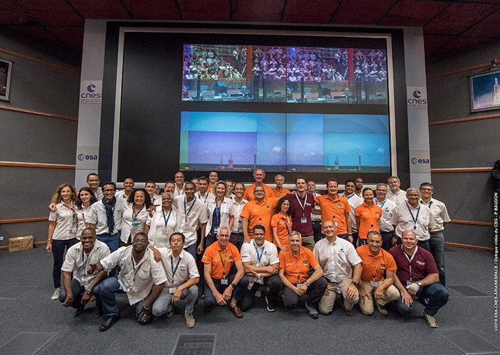
Countdown team at Kourou, Guiana control center for July’s four-satellite launch. (Photo: ESA/CNES/Arianespace, P. Baudon)
By Javier Benedicto Head, Galileo Programme department, European Space Agency
Since the declaration of initial services in December 2016, the European Space Agency (ESA) and the European GNSS Agency (GSA) have expanded Galileo’s system capabilities and service robustness with significant improvements of the ground segment and the last batch of four satellites launched by Ariane 5 in July. Once these satellites reach their final position and complete their in-orbit commissioning before the end of 2018, all 24 nominal slots of the Galileo constellation will be occupied.
Up to 22 satellites are planned to be commissioned in early 2019 and, eventually, the two FOC satellites injected in elliptical orbit should join the operational constellation after on-board software upgrade to provide for automatic health status flagging to users. This should lead to a total of 24 operational Galileo satellites supporting global PNT for users worldwide.
New Infrastructure Contracts
To further expand the system capabilities by 2020 and beyond, and reach Full Operational Capability (FOC), ESA has awarded new large industrial contracts in the context of the Exploitation Phase.
A contract to build and test another twelve Galileo satellites (so-called Batch-3) was awarded in 2017 to a consortium led by prime contractor OHB GmbH in Germany, with Surrey Satellite Technology Ltd in the UK as payload prime. These new satellites are based on the already qualified design of the previous Galileo FOC satellites. Production is advancing well, with first launch planned by late 2020.
With the Galileo constellation now expanded to 26 navigation satellites and plans to deploy additional Batch 3 satellites, the ground control infrastructure is undergoing a corresponding upgrades. In July, ESA awarded a new contract for the Galileo Ground Control Segment to GMV Aerospace and Defence, Spain. This contract includes upgrading the system architecture to manage a constellation of up to 41 Galileo satellites, updating obsolescent elements in the current system, improving operability linked to the provision of services and additional telemetry, tracking, and command capabilities to improve system robustness.
In October, Thales Alenia Space in France received a contract to upgrade the Galileo Ground Mission Segment and the Galileo Security Monitoring Centres (GSMC). This work includes upgrading Galileo’s system architecture to provide more accurate navigation products for broadcast by Galileo satellites, updating obsolescent elements in the current system and improving operability linked to the provision of services and enhanced robustness.
It will also include the construction of additional navigation message uplink and sensor stations. This contract will also augment the capabilities for implementation of the Public Regulated Service (PRS), the single most accurate and secure class of Galileo signals. Encrypted PRS signals will be made available only to authorized governmental users through approved national authorities. GSMCs in France and Spain will ensure the security monitoring functions for Galileo operational assets and manage PRS access and operations.
Growing Service Portfolio
The European Commission, GSA and ESA have jointly defined a broad range of service improvements and system capability enhancements to be deployed in 2019–2020, leading to FOC.
The newly qualified system infrastructure will support the broadcast of authentication information as part of the Open Service Navigation Message in E1; experimentation will start by end of 2019, leading to the possibility to offer trusted PNT to Galileo users.
Galileo will also be the first GNSS constellation to provide a Search and Rescue return link capability: as of 2019 the system will allow broadcast of acknowledgement of receipt message to users in distress with a very low latency, contributing to saving lives.
ESA has also started preparing the necessary modifications to the Navigation Signal Generation on-board the satellites to offer further capabilities to users after 2020. The signal-in-space will be enhanced with additional data transmitted in the I/NAV message, offering faster acquisition and more robust Galileo positioning on E1 and an encrypted navigation signal on E6 supporting authentication at signal level.
The new Galileo High Accuracy Service, soon entering the experimental phase, will consist in the delivery of un-encrypted high accuracy correction data in E6, enabling users to achieve sub-meter level positioning.
The usage of Galileo Open Service for aviation applications using horizontal advanced receiver-autonomous integrity monitoring techniques is being carefully assessed through measurements and review of the system design, including feared-events characterisation.
Longer Term Evolution
Galileo Second Generation has been the subject of technology pre-developments in the areas of platform and payload critical equipment, system techniques and processing algorithms, as well as system and segment Phase B studies over the past few years. We are now approaching the start of the implementation phase.
The European Commission, in close consultation with EU member states, has defined a decision roadmap aiming at very important future budget and programme implementation decisions in the course of 2019. In this context, ESA has launched a competitive procurement procedure for the first batch of so-called “Transition Satellites” with a broad range of enhanced and some new capabilities being considered. This includes improvements in the signal domain for faster acquisition and lower receiver power consumption, on-board clock technology, inter-satellite links, electrical propulsion, flexible payloads and power allocation by means of on-board digital technology and in-orbit re-configurability.
Transition satellites and related ground segment development contracts will begin by the end of 2019, aiming at in-orbit validation of second-generation capabilities from 2025 onwards.
EGNOS Evolution for Aviation
The adoption of Europe’s SBAS EGNOS by aviation is growing faster and faster. EGNOS will continue to evolve in the coming years. In particular, for 2019 and 2020, the evolutions under implementation focus on the obsolescence management of the hardware of some critical components, improvement of the system performances thanks to addition of new stations and system algorithms.
All these evolutions are planned to be qualified in 2021-2022, to continue to offer an excellent level of performance to Aviation Users until the operational take-over by the second generation of EGNOS V3,planned in 2025.
The European Performance-Based Navigation Implementing Regulation plans a growth from the current 35% to 66% in 2020 and 100% in 2024 of all European airports instrumental runways end-equipped with SBAS localizer performance with vertical guidance procedure.
On the aircraft manufacturer side, Airbus confirmed that it will continue equipping its aircraft; following the A350 family already equipped, both A320 and A330 families will be equipped for entry into service in summer 2020.
NAVISP
ESA’s Navigation Innovation and Support Programme (NAVISP), launched in 2017, will continue to boost member states’ industrial competitiveness and innovation in the upstream and downstream navigation sector, investigate the integration of satellite navigation with non-space technologies and complementary positioning and communication techniques, and study novel receiver-based techniques to counteract vulnerabilities and improve the robustness and reliability of GNSS.
Conclusion
The EU-built GNSS infrastructure systems EGNOS and Galileo are operational and serving users in Europe and worldwide. EC, GSA, ESA and European industries are committed to improvement plans over the next 2–3 years, with emphasis on endurance, resilience and robustness of the systems’ infrastructure, and delivering enhanced services.
For the longer term, the real challenge is to modernize the systems with new spaceborne and ground technologies, increase operational robustness and automation, and provide for additional system capabilities, while retaining a large degree of flexibility and in-orbit re-configurability to meet the long-term challenges and evolution of satellite-based navigation and timing.
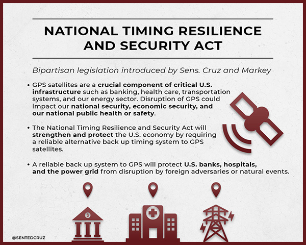
On Dec. 4, President Trump signed the Frank LoBiondo U.S. Coast Guard Authorization Act of 2018. Included in that bill was the National Timing Security and Resilience Act of 2018.
The act tasks the Secretary of Transportation with establishing a terrestrial backup timing system for GPS within two years.
Further, the bill ensures the availability of uncorrupted and non-degraded timing signals for military and civilian users in the event that GPS signals are corrupted, degraded, unreliable, or otherwise unavailable.
The law requires that, to the maximum extent possible, the backup system be:
terrestrial
wireless
synchronized to UTC
difficult to disrupt
able to penetrate underground and inside buildings
capable of deployment to remote locations
expandable to provide position, navigation and timing (PNT), and
able to work in concert with similar systems such as eLoran.
It also has provisions for the government to be able to establish the system through a commercial entity should it elect to do so. In such a case, it establishes several provisions that such a contract must meet.
Image: @SENTEDCRUZ
Timing a critical area. Timing has been an area of increasing focus and concern for both industry and government.
The U.S. Alliance for Telecommunications Industry Solutions (ATIS), the standards body for the wireless industry, has cited GPS timing as a point of failure for wireless systems. Last year ATIS wrote to key senators, encouraging them to establish an eLoran system to provide a second and much more resilient timing source for America.
In 2015 and 2016, the U.S. National Institutes of Standards and Technology issued reports that said America’s timing infrastructure was insufficient to support the growing internet of things (IOT).
The bill was sponsored by a broad coalition in the House led by Congressmen John Garamendi (D-CA) and Duncan Hunter (R-CA). Senators Ted Cruz (R-TX) and Ed Markey (D-MA) led the effort in the Senate, where the bill passed with an overwhelming majority.
U.S. Sens. Ted Cruz (R-Texas) and Ed Markey (D-Mass.) issued the following statements. “Establishing a reliable alternative timing system to GPS satellites is crucial to the national and economic security of the United States,” Sen. Cruz said. “If the current system were disrupted for even just a few hours, there would be an immediate threat to the American people, the economy, and our very way of life. Thankfully, Congress recognized the importance of addressing this issue. I am grateful for Sen. Markey’s leadership, and commend President Trump for signing this bill into law.”
“The nation’s banking, communications, electricity, and transportation sectors rely on the precise timing provided by GPS,” Sen. Markey said. “We cannot allow this vital system to be imperiled by natural phenomenon like solar flares or coordinated attacks like jamming. I am so proud that President Trump has signed this important bill into law, and I thank for Senator Cruz for partnering on policy that will enhance the resilience and reliability of this critical infrastructure.”
Defense attempt. Similar legislation that would have placed the responsibility for a terrestrial GPS backup system with the Department of Defense was introduced in 2015. While this was done with the acquiescence of senior DOD leadership, when the department later determined it did not want the responsibility, the measure failed.
While this new law is not a funding bill, Congress provided $10M for a technology demonstration in 2018. Also, having a law in place requiring the system paves the way for funding in future appropriations bills.
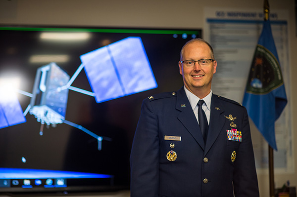
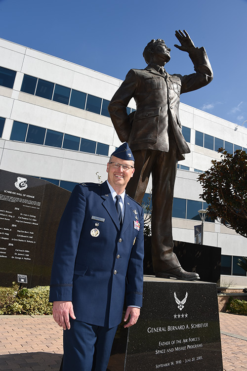
Col. Steve Whitney stands beside a statue of General Schriever at Los Angeles Air Force Base, home of the GPS Directorate. (Photo: U.S. Air Force/Joseph Juarez, Sr.)
By Col. Steven Whitney Director, Global Positioning Systems Directorate
Navigating across the world’s roads with GPS is easy. Navigating through the shifting construction zones, detours, and forks of the GPS Enterprise is not always so straightforward.
For that reason, the GPS Directorate has placed more emphasis on illustrating, both figuratively and literally, the roadmaps leading to the integration of the GPS Enterprise.
Before linking everything together, let’s start with an update on each major program effort. This way you can zoom out to see the path ahead; hopefully minimizing any “route recalculating” along the way.
Program Updates
The journey to build the new GPS III satellites has been full of twists and turns but we are now close to our destination – in this case the GPS orbit of 12,550 miles above the Earth.
We not only have 10 GPS III Space Vehicles simultaneously in production at Lockheed Martin’s manufacturing facility in Waterton, Colorado, but are also going full swing on preparations to launch our first vehicle in December 2018 on a SpaceX Falcon 9 rocket – more on this later. The GPS III satellites provide signals designed to improve the user’s ability to navigate.
In addition to the increased power and greater accuracy, GPS III adds a civil new signal, L1C, designed for compatibility with the international Global Navigation Satellite Systems (GNSS) community.
GPS IIIF. In September 2018, the Air Force awarded the GPS III Follow-on contract to Lockheed Martin. This $7.2B contract for 22 satellites was the result of a competitive process for a production effort. Based on the GPS III technical baseline, the GPS IIIF family of satellites embraces modernization and capability improvements in multiple areas.
First, a Regional Military Protection capability will provide increased anti-jam capabilities. Furthermore, a new Search-and-Rescue (SAR/GPS) payload will provide improved timeliness of global search-and-rescue operations. Additionally, a Laser Retro-reflector Array (LRA) payload will enable precise ranging measurements and the program will implement a Unified S-Band capability to address consolidation of telemetry, tracking, and commanding frequencies.
Finally, the program will host a redesigned Nuclear Detonation (NUDET) Detection System (NDS) solution that has a lower overall size and weight. We look forward to the continued partnership with Lockheed Martin and will be looking collaboratively at opportunities to add additional capabilities incrementally over the life of the 22 GPS IIIF satellite production line.
OCX, the Next Generation Operational Control Segment. Last year Raytheon delivered the initial system, known as OCX Block 0, to support the launch and on-orbit check-out of the GPS III satellites. This past year, we have actively utilized the system in a variety of exercises, training events, compatibility tests, and launch readiness events.
We also completed a comprehensive security review of the system to demonstrate our readiness to start operations. The system is ready to go. We continue to work the development of the OCX Block 1 system and are wrapping up the initial coding of the system early in 2019, leading into our integration and test campaign.
The journey over the past few years has been challenging, but we have emerged stronger, armed with better metrics, and a culture of integrated development (often called DevOps) which puts us on a path to success. There will be challenges and risks in the path ahead but rather than mountains to climb, I see these more as standard blocking and tackling of a software intensive program.
Col. Whitney next to an artist’s depiction of a GPS III satellite in orbit. (Photo: U.S. Air Force/Van Ha)
Legacy Ground Sustainment. Running in parallel to these modernization efforts is the all-important work to sustain our existing GPS infrastructure of our current Operational Control System (OCS). These sustainment efforts ensure GPS continues to be the gold standard in positioning, navigation, and timing but also are a crucial “on-ramp” to facilitate a smooth merge onto the modernized GPS capabilities.
Since 2014, the GPS program office has incrementally implemented several upgrades that not only maintain our satellite constellation delivery of GPS signal-in-space accuracy of 50 cm, but also significantly increases the cybersecurity posture of the legacy OCS.
These upgrades culminated with a deployment of the latest modification in October 2018, which finished a worldwide modernization of our entire control system hardware and software. This latest upgrade, known as Version 7.5, virtualized the network, implemented two-factor authentication, and improved encryption for mission data.
Legacy Ground Improvements. Given the delays in OCX, the Directorate is actively working two major upgrades to OCS to bridge the gap. The first is GPS III Contingency Operations (COps) modification which will allow the 2nd Space Operations Squadron (2SOPS) to command and control the GPS III family of vehicles in a mission state matching today’s legacy signals for all users world-wide. The second modification is M-Code Early Use, which enables 2SOPS to operationalize the Modernized GPS military signals (M-Code) navigation signals for the warfighter.
User Equipment. As I write this article, soldiers, sailors, marines and airmen are testing and integrating mature, next-generation GPS receiver cards providing more accurate and reliable position, navigation, and timing (PNT) solutions. In 2019, the first increment of Military GPS User Equipment (MGUE) is on track to complete card-level testing to inform Service procurement strategies.
This exciting work is the culmination of nearly two decades of modernization efforts throughout the GPS Enterprise. In the near term, we are utilizing M-Code capable lead platforms — USAF B-2 Bomber, USMC Joint Light Tactical Vehicle, USN Arleigh-Burke Class Guided Missile Destroyer, and Army Stryker combat vehicle — to prove out those capabilities.
The second increment of MGUE focuses on requirements for precision guided munitions, a joint common modular handheld unit, as well as circuit cards and components for low size, weight and power needs. With MGUE, the DoD and services are poised to have enduring PNT solutions the warfighter can leverage for years to come.
Integration Roadmaps
The delivery of individual programs is the stepping stone in the capability deliveries to the warfighter and our civilian users. However, it is our ability to unite a diverse collection of programs and stakeholders, across the GPS Enterprise, which defines our success as the GPS Green Monsters. We have done this by linking cross-program enterprise teams so the sum of the whole is greater than its parts.
Enterprise Road to Launch (ERTL). The goal is pulling together a series of firsts (new satellite, new ground system, and new launch provider), which has not been done before in the modern GPS Era, to deliver the spacecraft safely on-orbit and under control. Our journey to this historic launch has taken time and effort, and we are enthusiastically awaiting the final steps.
The first GPS III spacecraft is safely at Cape Canaveral and ready to go. The control system has been tested and run through its paces. The integrated launch team has conducted its exercises and reviews. All signs point to launch in December 2018.
The launch itself is a significant milestone, and marks a beginning of the orbital phase of GPS III. The Road to Launch team is prepared to execute the launch, the check-out and the day-to-day on-orbit housekeeping until the ground updates are complete to transfer the new GPS III satellite into the active constellation later in 2019.
Enterprise Road to Mission (ERM). The goal is bringing the GPS III satellites into the active constellation providing mission similar to today’s capabilities. A key enabler of the ERM IPT’s success is their development of the first-ever Enterprise “Integration Playbook”, which is the tangible, documented output of a significant dedicated planning effort.
The Playbook captures how all the pieces and efforts from each stakeholder community tie together to achieve Operational Acceptance of the first GPS III satellite, the USNDS payload, and the COps modification to OCS. The “Playbook” describes in clear and concise terms how these deliveries integrate across the GPS Enterprise, as well as how tasks and milestones from various stakeholders converge to achieve clear end states.
Enterprise Road to M-Code Mission, or ERM-M-Code. Shifting now to our military users, the purpose of the ERM-M-Code team is to lead the early delivery of a more robust, resilient, jamming/tampering-resistant PNT signal capability to warfighters.
The rollout of the operational M-code capability depends on the success of the M-Code Early Use modification to OCS, installation of new M-code signal monitoring equipment at sites around the globe, modification of mission planning software, Military GPS User Equipment Increment 1 development, service lead platform integration efforts, and operationalization of space receivers.
Our ultimate objective is to improve the ability of the Combined Space Operations Center (CSpOC) to respond to urgent PNT needs of the combatant commanders, as they engage more sophisticated adversaries. We remain closely aligned with our peers at USSTRATCOM, AFSPC and user communities.
Conclusion
It is an exciting time to be a GPS Green Monster! These roadmaps are by no means easy to create and execute. It is thanks to the remarkable people of your GPS Directorate that these multifaceted challenges are unraveled, aligned, and resolved. The team has worked incredibly hard this past year to position our systems for major, integrated deliveries over the next couple of years.
It has been the highlight of my career to serve with these men and women and I can’t wait to see where we — and the GPS Enterprise — go next.
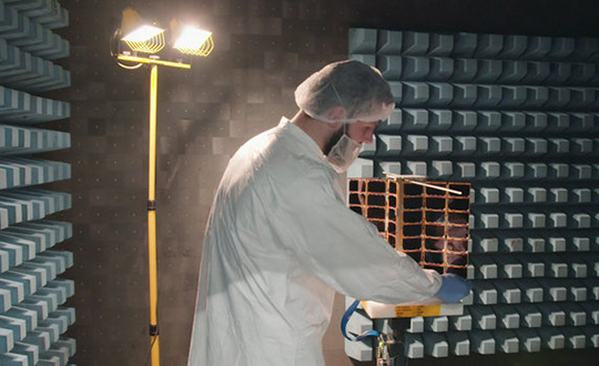
Two tiny GNSS-RO nanosatellites now circle the Earth, ready for action. The first European Pioneer mission lifted off Nov. 29 from Sriharikota, India, to put the satellites into orbit.
One of Spire’s Satellite Manufacturing Technicians (Tomasz Chanusiak) tests the Radio Frequency capabilities of a LEMUR2 nanosatellite in Spire’s cleanroom in Glasgow, Scotland. (Photo: ESA)
The shoebox-sized satellites were launched at 04:27 GMT into low Earth orbit by the Indian Space Research Organisation’s PLSV launcher, and opened their first communication windows with their owner, Spire Global, less than an hour after they separated from the rocket.
Both satellites were developed under ESA’s ARTES Pioneer programme, and will aim to prove the value of using nanosats for space-based GNSS Radio Occultation (GNSS-RO).
GNSS-RO. GNSS-RO is the process of using satellites to measure how GNSS signals are refracted by the Earth’s atmosphere. Experts can use these measurements to glean temperature, pressure and humidity information for weather forecasting and climate change monitoring.
In contrast, weather data gathered by weather balloons and aircraft can only reach certain altitudes, leaving the higher atmospheric layers untouched.
Satellites have no such restrictions. They can gather massive amounts of this data from the ground up to the mesosphere as they fly over the Earth. This is usually done by large satellites. Spire’s nanosatellites weigh just 5 kg each, and were assembled and tested entirely by Spire in under three months, at their headquarters in Glasgow, Scotland.
Named “Space as a Service,” the Spire Pioneer mission intends to prove that nanosat GNSS-RO is a commercially viable alternative to traditional methods.
Two nanosatellites built by Spire Global were launched into low Earth orbit Nov. 29. (Photo: ISRO)
The two tiny satellites will collect and distribute GNSS-RO data during their commissioning phase, after which they will go into full commercial data production mode, gathering weather information for meteorological institutions, maritime and aviation customers on demand.
ESA’s Pioneer initiative partners with companies like Spire to help them provide this kind of in-orbit demonstration and validation for third parties.
“We saw a gap in the market for what we call space mission providers: companies that offer all aspects of a space mission to validate a new technology or service for the benefit of others,” said ESA Pioneer Programme Manager Khalil Kably. “ESA is always looking to champion innovation in the space industry, and the idea of Pioneer is that these space mission providers can help this by being a one-stop shop for in-orbit demonstration and therefore reduce the barriers and complexity that can stifle new ideas.”
“Spire has been focused on developing unique data sources with high frequency updates for the entire Earth and has over 60 LEMUR-2 class satellites deployed in space complimented with a global ground station network,” Spire Global CEO Peter Platzer said. “Under Pioneer, we can offer our extensive experience in manufacturing and managing small spacecraft like these to those who cannot afford to waste money and time doing it themselves. This work with ESA helps further support the global development of commercial aerospace’s potential to make space access universal.”
“These incredibly clever shoebox-sized satellites built in Glasgow could slash the complexity and cost of access to space, presenting an exciting opportunity for the UK to thrive in the commercial space age,” UK Space Agency Chief Executive Graham Turnock said. “Through our £4m development funding, the government’s Industrial Strategy and by working closely with our international partners, we are helping UK businesses transform their ideas into commercial realities, resulting in jobs, growth and innovation.”
The Orientale Basin in a 4K NASA video of the lunar surface using observations from the Lunar Reconnaissance Orbiter. (Photo: NASA)
Russian positioning satellites could circle the Moon by 2040.
In a draft document describing Russia’s program for lunar exploration, plans include deployment of navigational and communications satellite groupings in lunar orbit.
The document, adopted at a Nov. 28 joint meeting of Roscosmos and Academy of Sciences officials, was obtained by Russian news agency Sputnik, which described it here.
According to the document, the tasks described for 2025-2030 include “the delivery to the Moon of a series of spacecraft for orbital research and the establishment of a global communications and positioning system.”
The concept envisions the deployment of a lunar satellite navigation constellation between 2036 and 2040.
Russia’s Earthly navigation constellation is GLONASS.
A Roscomos press release Nov. 28 says a moon base is the agency’s top priority. “The interest of mankind to the moon is associated primarily with the fact that unique regions with favorable conditions for the construction of lunar bases were discovered on the satellite. The implementation of the lunar program will be held in several stages until 2040.”
Russia will reportedly implement its new strategy in three phases: the launch of an orbital station, a manned mission to the surface, and the eventual construction of a permanent base.
Changes are in store, and soon to become real. (Isn’t that always the way?) But truly, while continuing to cover every front of GNSS and PNT development, both businesswise and technologywise, we are improving the methods by which we do so. After listening to your input, of course.
Among the questions we asked you in the course of the 2018 State of the GNSS Industry Survey was:
“Please share story ideas with the editors of GPS World and/or let us know if your company is doing something unique.”
Among the answers you gave — here’s where the bit about your future comes in — were these, and here’s some of the content with which we’ll be seeking to fill 2019’s pages:
Using a manned experimental jet aircraft to simulate low observable cruise missiles for countermeasures flight testing.
UAV remote sensing legal issues.
Transitioning from GPS to internal building locating.
Definition of safety standards for autonomous road vehicles.
IoT sensors for remote monitoring with GPS and mobile for asset monitoring, biofuel stockpiles, personal tracking.
Data point collection for integration into Esri parcel fabric / CadNSDI development.
Increasing lifespan of professional surveyors.
Modernizing National Height System, validating existing geoid model, running precise first-order leveling, and taking GNSS observations.
More on geodesy, for example, mapping projections, ellipsoids, geooids, and so on.
Augmented GPS for integration with the 911 Emergency system.
After 30 years in government doing threat analysis and 18 years consulting/contracting, I plan to smell the flowers, but keep my hand in where needed. I have noticed, on issues of national security that are technology driven, we are often filling even the lowest managerial level with non-technical persons, who are often not qualified to assess the analysis they must review. Hence the product and the analysis suffer. I’m guessing the same thing is happening at the systems acquisition world. And might be a major factor in the “business as usual” cost and schedule overruns. We need fewer “suits” and more sweatshirts.
Services of the Quasi-Zenith Satellite System (QZSS) officially started on Nov. 1, according to a statement from Japan’s National Space Policy Secretariat, Cabinet Office.
Government and industry hope the turn-on will generate new services worth nearly 5 trillion yen ($44.4 billion) by 2025 as players like SoftBank Group, Mitsubishi Electric and Hitachi plan applications in automated driving, farming and more.
“Our lifestyles would be impossible without GPS,” Prime Minister Shinzo Abe said at initialization ceremony marking the start of the service. The Michibiki satellite constellation, known officially as QZSS, would let Japan turn “a new page in history,” he continued.
The system keeps at least one of the current four Michibiki satellites over Japan at all times, offering an advantage over GPS-only services with a precise bird’s-eye view uninterrupted by mountains or tall buildings. With special receivers, the satellites can narrow margins of error to 10 centimeters.
The signal is free for anyone with a device capable of receiving the signal.
Prime Minister Shinzo Abe delivers a congratulatory address as QZSS is officially launched. (Photo: Japan Cabinet Public Relations Office)
Japan’s cabinet and other government bodies have invested 120 billion yen in QZSS. Expectations are particularly strong for applications in the rapidly advancing field of automated driving, with some businesses estimating the market for positioning services in that field alone at roughly 500 billion yen.
QZSS offers lane-level positioning capability, is a key step towards auto autonomy.
Michibiki means guidance in Japanese. In his remarks, Abe said the satellite-based augmentation system (SBAS) “will guide us to Society 5.0, the society of the future. There are high hopes for the ever greater use of this satellite system in a wide range of fields. The government aims to expand the system to a seven-satellite constellation by FY2023, with the goal of achieving an even more stable positioning service.
“More than 10 years have passed since its conception. I am sure that taking on this challenge, the first of its kind in the world, must have required much hard work. I would like to express my utmost respect for the efforts of the engineers responsible for the development and all those involved with this project.
“To what degree will the ‘Michibiki’ change our lives? I hope to follow its progress with great excitement, together with you all.”
By Senior Airman William Tracy, 50th Space Wing Public Affairs
The 2nd Space Operations Squadron took formal command of Architecture Evolution Plan 7.5, the largest GPS architectural change in operational history, after its successful installation at Schriever Air Force Base, Colorado, Nov. 16.
“AEP 7.5 is a milestone in GPS history and improves our cybersecurity capabilities and postures us to better operate in a contested, degraded and operationally limited environment,” said 1st Lieutenant Jonathan Campbell, 2nd SOPS assistant operations flight commander.
The 2nd SOPS installation replaced 600,000 lines of code in AEP and implemented more than $29 million worth of hardware and software changes.
Additionally, AEP 7.5 sets the platform for the installation of AEP 8.0, which will deliver the capability to command and control GPS III satellite vehicles — the first GPS III satellite scheduled to be launched from Cape Canaveral Air Force Station, Florida, next month.
Campbell said AEP 7.5 is a significant step up from the previous AEP 7.3, with overall improvements allowing Airmen to command and control satellites with better efficiency.
The program’s successful installation was the result of extensive training from a Mission Operations Transfer at the squadron’s Alternate Master Control Station at Vandenberg Air Force Base, California. Both rotations of the Space Mission Force crew structure were activated to ensure full operational capabilities at both sites, performing security control assessments on the system and taking other measures.
“Training consisted of acclimating to AEP 7.5, learning how to navigate it and utilize it to the best capability,” said Senior Airman Ryan Lape, 2nd SOPS satellite systems operator. “Because our constellation was so big, upon taking command at Schriever we had to iron out the changes on a large scale.”
Campbell said the hard work was worth it — the successful installation and command of AEP 7.5 through the squadron’s efforts will prepare for changes in the near future.
“This will provide combat ready space warfighters delivering position, navigation and timing to optimize the full range of Air Force, joint force and civilian operations, across all domains,” he said. “The updated hardware provided in the AEP 7.5 installation lays the foundation for a software update next year enabling the command and control of GPS Block III vehicles.”
Campbell added not only will the installation advance the 2nd SOPS’s mission, but the 50th Space Wing’s as well, helping evolve space and cyberspace warfighting superiority through integrative and innovative operations.
“The capabilities provided in this update, and those coming in the next year, provide a significant improvement to our warfighters,” he said.
With this milestone, Campbell said the continuation of the U.S. military’s dominance in position navigation and timing systems is secured.
“This update furthers the U.S. military’s and Schriever AFB’s position as the center of satellite command and control and space operations,” he said.
Lape said the milestone will make an impact outside of the military as well.
“We are the premier PNT system in the world with the largest satellite constellation,” he said.
“With measures like these, it will definitely make our adversaries think twice.”
The 2nd Space Operations Squadron operations floor is a flurry of activity during 2nd SOPS’s formal command of Architecture Evolution Plan 7.5. (Photo: USAF/Senior Airman William Tracy)
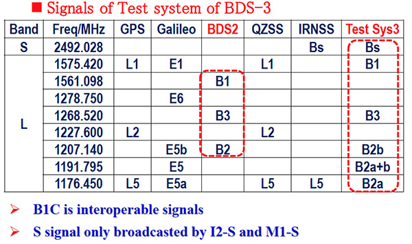
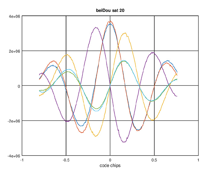
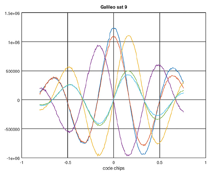
Recently launched satellites of BeiDou Phase 3 program have started broadcasting new signals. Javad GNSS announced successful tracking of these signals and provided the adjacent figures.
Interface control documents (ICDs) for B1C and B2A signals are available, while an ICD for the other signal, called B2B, has not yet been published. The company tracked the signal on the 1207.14 Mhz frequency on BeiDou’s satellites 32, 33 and 34, and subsequently saw that this signal is available on all recently launched BeiDou Phase 3 satellites, and tracked it successfully.
This B2B signal plus B2A signal together form an AltBOC(10,15) signal on 1191.795 MHz — JAVAD GNSS calls it BaltBOC. Assuming that BOC parameters of this signal are similar to Galileo’s, the company tracked this. Figures 1 and 2 show BeiDou andGalileo (BaltBOC and altBOC) discriminator curves; they appear identical.
Figure 1. BeiDou AltBoC signal. Red and blue: I of B2A(E5A) and B2B(E5b) sub-signals; purple and yellow: Q of B2A(E5A) and B2B(E5b) sub-signals (their sum is zero); green and aqua: I (early-minus-late) of B2A(E5A) and B2B(E5b) sub-signals. (Chart: Javad GNSS)Figure 2. Galileo AltBoC signal. Colors same as Figure 1. (Chart: Javad GNSS)
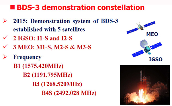
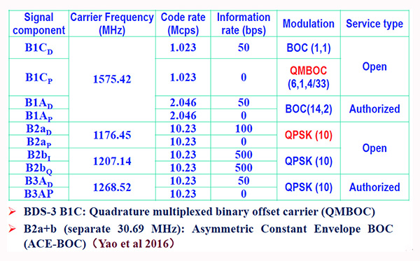
According to another source, the signals are mentioned in some publications (Figure 3, 4 and 5 from an official Chinese government presentation at the International GNSS Service Workshop, Oct. 2018) and intended to be open signals, but an ICD is presently missing. However there appears to be some clarity now, that the modulation of B2a+b is an “ACE-BOC” modulation, which is similar to but formally different from “AltBOC.”
Figure 3. BDS-3 demonstration constellation. (Chart: Javad GNSS)Figure 4. Signals of test system BDS-3. (Chart: Javad GNSS)Figure 5. BDS-3 signal modulations. (Chart: Javad GNSS)
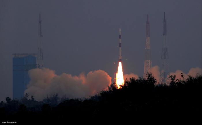
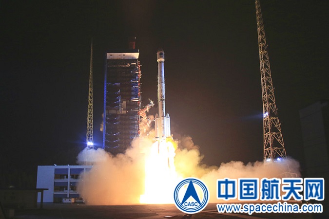
The launch and deployment of the 42nd and 43rd BeiDou satellites complete the basic BDS-3 constellation.
China has successfully sent twin BeiDou satellites into space by a Long March-3B launch vehicle (with an Expedition-1 upper stage) from the Xichang Satellite Launch Center, at 02:07 am, on Nov. 19. The twins, both medium Earth orbit (MEO) satellites, are the 42nd and 43rd of the BeiDou Navigation Satellite System (BDS), and the 18th and 19th of the BeiDou-3 family.
Photo: CASC screenshot
The satellites successfully entered their designated orbit after more than three hours of the launch, and will join the constellation with the 17 previously launched BDS-3 satellites, after completing in-orbit test.
The successful launch marks that the basic BDS-3 constellation has successfully been deployed. Networking of the constellation and assessment on its performances will be carried out in the near future.
Plans are for the BeiDou-3 constellation to be put into operation before the end of this year, to provide basic navigation services to countries and regions participating the Belt and Road initiative, which will be a key milestone for BDS in expanding service areas from regional to global.
The BDS-3 project was officially launched in 2009 with state approval, and a demonstration system was completed in 2016. Having verified the new-generation navigation signal system architecture, the BDS-3 development followed up with a three-step pattern, to construct its pilot, basic and nominal constellations respectively, according to the China Satellite Navigation Office,
On Nov. 5, 2017, the first pair of satellites for the BDS-3 constellation was launched from Xichang Satellite Launch Center. By the end of March 2018, a pilot constellation consisting of 8 BeiDou satellites was built.
At present, the project is progressing smoothly, and the basic constellation consisting of 19 BDS satellites will soon be operational. In the future, BDS with global coverage will be completed by the end of 2020.
Since November 2017, the past year has witnessed a highly intensive launch of the China’s BDS constellation. With the joint efforts of the whole team participating in this project, 11 launches have been completed within one year, while 19 BDS-3 satellites and 1 BDS-2 satellite have been successfully sent into space.
In particular, since July 2018, seven launches have been conducted to deliver 12 BDS satellites into orbit, with the shortest interval between launches being only 17 days. Both highly intensive and high success rate of launches set a new record in the history of the BDS constellation development.
The satellites and the launch vehicle (with an Expedition-upper stage) for this mission were developed by the China Academy of Space Technology and the China Academy of Launch Vehicle Technology respectively, both are affiliated to the China Aerospace Science and Technology Co., Ltd. The launch was the 291st mission of the Long March rocket series.
Currently, the BeiDou system comprises two families of operational navigation satellites; BeiDou-2, also known as Compass, presently consists of 15 operational satellites in Geostationary Orbit (GEO), Geosynchronous Orbit (GSO), Inclined Geosynchronous Orbit (IGSO) and Medium Earth Orbit (MEO).
The new BeiDou-3 series, on the other hand, only has operational MEO satellites at the moment, although China is testing the first BeiDou-3 GEO satellite (BeiDou-3G1) and plans to launch at least four GEO and GSO satellites in 2019.