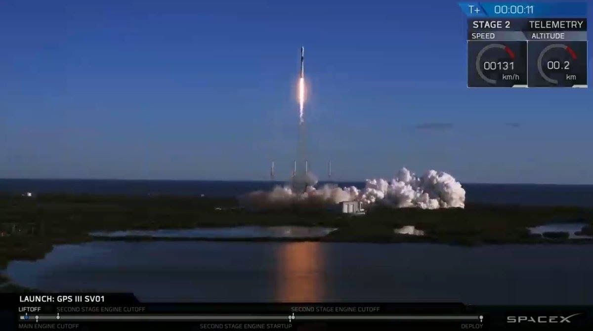
SpaceX’s Falcon 9 rocket orbited the first GPS III satellite on Dec. 23, 2018. (Photo: SpaceX)
On December 23, the first GPS III satellite entered an orbit around Earth, after a five-day delay. This first of a new breed of GPS satellite also experienced a four-year delay, with its original launch scheduled for 2014.
While the system has experienced more than its share of problems, at the start of a new year I want to focus on the benefits to come.
Few of us realized how much our lives would change when the first GPS satellite was launched in 1978. GPS III could bring about a similar trajectory of changes. Civilians can expect a more reliable and accurate service. The smartphone message “searching for signal” could become a dim memory.
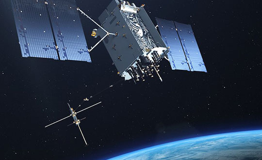
GPS III signals will be three times more accurate than the current GPS Block II models. The navigation payload has more than three times reduction in range error and up to eight times increase in power — its signals should be much easier to pick up under tree canopy, within urban canyons and inside buildings.
GPS III also has four civilian signals. The L1C signal is interoperable with international GNSS, meaning users can receive signals from any country’s satellites. Also, using two civilian signals means GPS III can directly detect and correct ionospheric errors.
In addition to a standard wide-angle antenna for broad coverage, the GPS III satellites include a high-gain directional antenna that will operate with 100 times (+20 dB) the power of the wide-angle antenna, and will be exclusively for use with M-code (military) transmissions. This directional antenna’s spot beam covers an area 120 miles at high power— boosting the power of military GPS signals by 100 times in specific regions, making military GPS even harder to jam.
These advantages may not reach the battlefield for a decade. The new constellation will take time to build. The GPS III constellation is projected to be fully capable in June 2023, when 10 Block IIIA satellites are expected to be in orbit. Ten follow-on satellites are planned to be placed into orbit from 2026 to 2034.
Back here on Earth, equipment makers will need time to develop and supply warfighters with military GPS user equipment (MGUE) that can take advantage of all that GPS III has to offer.
Calendar pages allows seem to fly by quickly, and 2018 was no different. While many of the items discussed in last year’s review continued to be topics of advancement, there are several new sources of technology, data collection and potential issues for surveyors going into the new year.
Let’s look back at the stories that affected the surveyor and their use of GNSS technology in 2018.
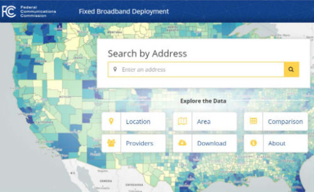
FCC broadband accuracy
The race across America to provide better broadband coverage hit a snag late in 2018 when critics of the Federal Communications Commission (FCC) voiced their displeasure with the accuracy of maps produced to depict the coverage of broadband access.
These critics are pressuring the FCC to verify internet coverage and speed of data availability in rural areas as reported by the broadband companies.
The FCC unveiled a new broadband map in February 2018. (Image: FCC)
These broadband companies are only required to report on the advertised availability and data speeds and not the actual coverage/speed of the installed networks. Critics of the FCC have found that information used from the broadband providers overstates the available speeds and number of internet service providers, thus allowing the FCC to produce mapping of broadband that is not correct.
Because of this incorrect reporting, it is estimated that almost 40 percent of rural America doesn’t have access to broadband data with no formal plan of rectifying this situation. The FCC has stated that they will investigate these coverage maps in order to determine if monies distributed to broadband providers were not used in accordance with the promised delivery of coverage and data speed.
Why does this matter to surveyors? As previously discussed in past columns, the reliance on the real-time network capability of GNSS is one of the biggest time and production savers for the surveyor and for those working in rural America is no exception.
Not just in small towns but out in the open where large parcels are being surveyed for many different reasons, including pipelines, wind and solar installations and title conveyances. By having broadband available use by surveyors, these tasks can be accomplished with shorter timeframes and less steps to keep critical data in compliance with established coordinate systems.
While this bill received lots of attention because of the FAA implications, the portion of the bill concentrating on geospatial oversight will have a lasting effect on the governance and development of the national mapping industry.
For many years, the ever-developing amount and sources of geospatial data has been growing within several different agencies of the United States government. This bill was established to help streamline the efforts and availability of geospatial data by assigning specific agencies to oversee the development and introduction of new technologies.
The biggest takeaway from this bill will be the reduction of agencies working on concurrent data sets for public and private use and therefore streamlining the opportunities to introduce newly acquired information into critical programs, (such as FEMA floodplain mapping, GAO asset management, etc.).
Part of the reason I wish to highlight this bill was the efforts of the National Society of Professional Surveyors (NSPS) to keep the state professional licensing laws intact, the use of private sector businesses for providing surveying services, and to keep quality-based selection (QBS) as the primary tool for awarding contracts for procurement services.
Because of the actions and reasoning by NSPS, the authors of the bill withdrew the language that would allow “low bid” opportunities within these contract awards. This influence by NSPS is a prime example of how a profession can influence legislation through our democratic process.
Galileo implementation, Beidou installation, GPS Block III launches
SpaceX’s Falcon 9 rocket orbited the first GPS III satellite on Dec. 23, 2018. (Photo: SpaceX)
In November 2018, the FCC opened a new chapter in GNSS observation by approving a waiver to allow GNSS receivers to utilize Galileo transmissions for location determination without a specific FCC license. Traditionally, the FCC would require licensing of public, receive-only GNSS equipment used with any foreign-based systems but worked with several US agencies to create a waiver to allow faster implementation to use the Galileo signals.
It should also be noted that the Chinese government has been rapidly building the latest stage of their own GNSS constellation, the BeiDou system. The United States and China have been promoting cooperation to allow each side to better understand the current workings of GPS and BeiDou, (GPS-BeiDou Statement). China is currently completing its third phase of the navigation system that potentially will surpass the United States GPS constellation in data availability and accuracy, (See GPS World“Directions 2019: BeiDou accelerates global deployment,” December 2018).
Not to be outdone, the U.S. has begun its implementation of their next wave of satellites, the GPS III containing the latest technology, the L1C civil signal, with improved accuracy and anti-jamming programming. On Dec. 23, the SpaceX Falcon 9 rocket delivered the GPS III SV01 into its intended orbit (SpaceX Launch) with more launches scheduled for additional satellite vehicles in 2019.
These efforts to increase satellite coverage and accuracy will only improve the use of GNSS receivers by surveyors. While I look forward to software and receiver upgrades to take advantage of the newer birds, we still need a backup plan in case of international conflicts and a reduction/discontinuation of GNSS service.
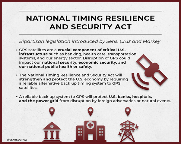
GPS and terrestrial backup
The Frank LoBiondo U.S. Coast Guard Authorization Act of 2018, which also included the National Timing Security and Resilience Act, was signed into law on Dec. 4 and directs the Secretary of Transportation to establish a terrestrial back system for the U.S. satellite navigation system within a two-year period (see “GPS to get terrestrial backup system”).
The bill lays out specific conditions for the backup plan:
terrestrial
wireless
synchronized to UTC
difficult to disrupt
able to penetrate underground and inside buildings
capable of deployment to remote locations
expandable to provide position, navigation and timing (PNT), and
able to work in concert with similar systems such as eLoran.
However, this bill did not provide any funding for the creation of this system but now allows the introduction of appropriations in future bills and acts. As I have written in past columns (see “The day GPS went away,” September 2017), it won’t be a matter of if but when something happens to our current GNSS capabilities and we need to develop this backup plan yesterday.
Dual-band GNSS cellphones as the new norm
My last submission featured the latest in chipset for cellphones and utilizing dual-frequency GNSS signal reception. Xiaomi, based in Beijing, China, introduced the Mi 8 phone with a dual-frequency GNSS chip in the Spring of 2018 to rave reviews.
This chip frequency reception (E1/L1+E5/L5) is targeted to embrace the Galileo and GPS constellations for increased accuracies (within a decimeter) well beyond the current norm for smartphones (typically 1-3 meters +/-).
Since then, Xiaomi has released the Mi Mix 3 and Huawei has released the Mate 20, Mate 20 Pro and Mate 20 X, all with dual-frequency chipsets. However, all of these phones are not available in the U.S., and the security issues with Huawei has been well documented (CNBC Report, February 2018).
The reason I still bring these up for the surveyor is because soon we will have dual-frequency capability on the phone in our pockets here in the U.S. Such phones can greatly increase efficiencies, especially when used during reconnaissance efforts. I believe many more phone manufacturers will begin to incorporate dual-frequency chips in their future models to increase location accuracies for the users and take advantage of upcoming network enhancements (see GPS World“Dual-frequency GNSS smartphone hits the market,” June 2018.)
Surveyors vs. technology disruptors
The Mi 8 smartphone offers dual-frequency capability. (Image: Xiaomi)
One of the biggest stories in the surveying world made national headlines after a start-up “GEO-spatial” consultant created by retired bankers was sued by the Mississippi Board of Licensure for Professional Engineer and Surveyors for having “engaged, and continues to engage in the practice of surveying while not licensed by the Board.” (Madison County, Mississippi, Chancery Court.) While the initial suit remained under the national radar, the countersuit by the consultant and subsequent articles in national websites brought the situation to the front page.
The issue at hand is the creation of “plats” combining a legal description for a parcel with a high-resolution photo (captured by various means, including UAV) and depicting said legal description on the photo for use by banks and other financial institutions for risk evaluation. Their argument is that they have “First Amendment rights” to provide public information (the legal description) on a recent aerial photograph in order to provide an exhibit for lenders to review and make loan decisions. Banks are now paying much less in fees to this company for an exhibit instead of a Plat of Survey provided by a licensed surveyor, yet the exhibit provides no assurance (or certification) to its validity and/or any metadata for the represented information.
The subsequent articles by both Bloomberg and Ars Technica writers liken the situation to Airbnb versus hotels and Uber/Lyft versus taxi drivers as a new “disruption in technology” brings forth change to previously licensed professions. In fact, the author of the Bloomberg article stated, “the clients are sophisticated, and they’re not complaining.”
Using this mentality, we could apply it to any licensed profession and allow services normally regulated by laws to be administered by non-professionals, as long as the client “is sophisticated and not complaining.” This means anyone can provide accounting, medical, dental or even law services if the client is satisfied. As previously published here, (see GPS World“Accuracy, precision and boundary retracement in surveying” July 2017), a boundary survey is not simply a mathematical figure from a legal description. It takes a trained person to know how to properly relate a legal description to a physical parcel and professional licensing provides that assurance (and protection) to the public.
This situation falls squarely in the GNSS wheelhouse for surveyors, especially as technology advances and accuracies become smaller with progress, (i.e. GPS Block III, BeiDuo, Galileo, etc.) and the ability to measure with higher positional accuracy, (i.e. Xiaomi Mi 8 and other to follow).
The surveying profession has joked for years that when these technologies do come forward, many unlicensed “professionals” will come forward with their measuring devices (phones) and locate property lines as part of their service.
But for now, it isn’t just the physical location by GNSS measurement we should worry about; it is the high-resolution photo software, GIS data sources and those folks enterprising enough to put all this information together. The surveying profession will need to ramp up its message to public to help better define what the licensed surveyor provides versus the “we can do it much cheaper and faster” stories. More often than not, you get what you pay for.
Data collection advancements
Emlid Reach RS with iPad. (Photo: Tim Burch)
While 2018 didn’t see any revolutionary changes to GNSS data collection, several small advances are noteworthy. Besides the previously mentioned dual-frequency cellphones, we are also seeing more integration with the cellphones themselves as data collectors in conjunction with stand-alone GNSS receivers (see GPS World“University research uses smartphones for precision GNSS,” September 2018).
Several of the major survey equipment manufacturers are joining a group of small GNSS start-ups by introducing single- and dual-frequency receivers to work with both Android- and iOS-based phones and tablets for more cost-effective positional solutions.
Another trend that is becoming very popular is the use of post-processing kinematic (PPK) solutions with many of the newest models of multi-rotor and fixed wing UAVs. The early (and expensive) trend of aerial vehicles produced by the major surveying equipment manufacturers insisted on installation of a dual-frequency RTK receiver in order to provide a more robust control system for the orthometric photo process. Because there is still a need to combine the still photos from the UAV flight via various “stitching” software, the need (and expense) of RTK within the receiver, while a nice feature, has become overkill for most aerial needs. However, there are times and applications when a fixed-RTK location could be useful, especially during emergency situations when needing to utilize the UAV for live streaming purposes.
The last big trend to gain popularity comes from Propeller, a young tech company from Australia that provides both a control point product and data reduction/reporting service. Their revolutionary ground control point (GCP) target, the Aeropoint, is becoming a very popular item for UAV pilots worldwide. These 24-inch (61-CM) square foam targets contain a single-frequency GNSS receiver that collects RINEX data while performing your UAV flight. Spread these targets around your site, setup and perform your survey, then download the target data to the Propeller app on your phone/tablet. The app automatically uploads the data to the company’s site and processes the geographical location for each target into your chosen coordinate system. It truly is that simple and the Propeller folks have made it easy to use. Their online software, Propeller Platform, is also available for photo/data processing and site analysis/visualization/volume computations. They, too, are now teaming with DJI to offer PPK solutions combining Aeropoint data along with Phantom 4 RTK photo data in a convenient, streamlined process.
For 2018, our firm (SPACECO Inc) expanded our UAV program in several ways to take advantage of these trends. First, we been using the Emlid Reach RS single-frequency GNSS receiver utilizing a Bluetooth connection to an iOS-based tablet to GCP’s for our UAV program. The receiver’s low cost and ease of use with an RTN network has been a pleasant change from typical surveying equipment. We also use Propeller’s Aeropoints in locations where the RTN coverage is not readily available. For sites that are substantial (typically 300 acres+), we often send our data to the Propeller Platform for photo stitching and data reduction to take advantage of their computing power.
WingtraOne. (Photo: Brian Kravets, SPACECO Inc.)
Lastly, we wanted to expand our fleet of quad-rotor UAV’s to include a fixed wing model for larger sites. A visit with the Wingtra crew at InterGeo 2017 in Berlin convinced me that a vertical take-off and land (VTOL) model would be a great addition, so we took delivery of our WingtraOne this past summer. The ease of use and amount of project space the Wingtra can cover was already great but we’ve added the PPK module to reduce the amount of GCP’s necessary, especially in inaccessible areas. All these additions to our survey department (carefully vetted and purchased; no freebies from any of the manufacturers!) have provided new ways to expand our services to our clients and allows us the opportunity to enjoy what we do along the way. It is my pleasure to report from personal experience that these trends are solid and will continue to increase our abilities and productivity for days to come.
What’s next for 2019?
Some of the items I see gaining traction in 2019 will include additional sensors for UAV’s (LiDAR, hyperspectral, infrared), continued improvement in cost effectiveness of laser scanners and LiDAR, increased interest in SLAM (simultaneous localization and mapping) technology and, of course, more geolocation services tied into autonomous vehicles/delivery. Will 2019 be the year Amazon drops my packages by UAV at my front door? As fast as these technologies are developing, I wouldn’t bet against it.
SpaceX’s Falcon 9 rocket orbited the first GPS III satellite on Dec. 23, 2018. (Photo: USAF)
After several launch delays, the first GPS III satellite successfully deployed from a SpaceX Falcon 9 rocket, rising from Cape Canaveral on Dec. 23.
By Jan. 2, the satellite had circularized its orbit at an altitude of 12,550 miles to begin a period of checkout and testing that could last up to 18 months, before entering service. The satellite, built by Lockheed Martin, will serve in space for 15 years.
Known as GPS III SV01 and nicknamed “Vespucci,” it is the first in a new generation of GPS navigation stations with improved services and longer lifetimes to ensure the U.S. military-run network remains available to troops and civil users around the world for decades to come.
“Launch is always a monumental event, and especially so since this is the first GPS satellite of its generation launched on SpaceX’s first national security space mission,” said Lt. Gen. John Thompson, commander of the U.S. Air Force’s Space and Missile Systems Center and the Air Force’s program executive officer for space. “As more GPS III satellites join the constellation, it will bring better service at a lower cost to a technology that is now fully woven into the fabric of any modern civilization.”
The satellite’s earlier scheduled launch date of Dec. 18 was scrubbed, reportedly due to liquid oxygen thermal limit constraints aboard the SpaceX Falcon 9 Block 5 rocket’s first stage reaching safety limits.
A second attempt on Dec. 19 was also ruled out due to ongoing evaluations into the sensor issue. Then ensued three days of weather delay, awaiting favorable wind conditions, until Dec. 23.
After several delays, the first GPS III satellite has successfully deployed from the SpaceX Falcon 9 rocket, which launched from Cape Canaveral Air Force Station in Florida at 8:51 a.m. EST on Dec. 23. (Photo: Lockheed Martin)
GPS III SV01 was originally scheduled to ride aboard a United Launch Alliance (ULA) Delta IV M+ rocket. ULA and its prime partners, Lockheed-Martin and Boeing, have conducted every GPS satellite launch since the start of the program. However, due to an assortment of issues variously involving delayed technology development and lawsuits regarding competitive bidding, the Air Force re-opened the contract process as part of its Evolved Expendable Launch Vehicle (EELV) program — “evolved” signifying that the rocket can be recovered and reused.
Recycling Rockets. ULA did not bid on the re-opened contract, citing concerns over the selection process and potential risks with the anticipated lower launch cost. In 2016, the Air Force selected SpaceX to take over most GPS III launches.
SpaceX’s Falcon 9 for this launch used a new first stage core, the B1054. Although it has re-use capability, it flew in an expendable configuration this time, with no landing legs and no grid fins. It was disposed of into the Atlantic Ocean after separation from the second stage.
In other missions, after the satellite-bearing stage separates from the rest of the rocket, the remaining core launcher fires additional fuel to return intact to land or to sea aboard an Autonomous Spaceport Drone Ship (ASDS), a converted barge awaiting in the Atlantic or Pacific Ocean.
New Generation. The GPS III constellation, once fulfilled, will bring three times better accuracy and up to eight times improved anti-jamming capabilities. Spacecraft life will extend to 15 years, 25 percent longer than GPS satellites on-orbit today. GPS III’s new L1C civil signal also will make it the first GPS satellite broadcasting a compatible signal with other international global navigation satellite systems, like Galileo, improving connectivity for civilian users.
Lockheed Martin developed GPS III and manufactured GPS III SV01 at its GPS III Processing Facility near Denver. In September 2017, the Air Force declared the satellite “Available for Launch” (AFL) and had the company place it into storage.
In 2018, the Air Force called the satellite to Florida, and it was delivered on Aug. 20. At that time, the Air Force declared the second GPS III AFL and in November called it up for 2019 launch. GPS III satellites SV03-08 are now in various stages of assembly and test.
NovAtel has been awarded a contract from the United States Federal Aviation Administration (FAA) to design, produce and deliver 40 next-generation Ground Uplink Station (GUS) Signal Generators to support the FAA’s safety-of-life WAAS navigation service. The service provides safety-critical infrastructure for the North American aviation navigation network.
GUS signal generator. (Photo: NovAtel)
The contract also includes ongoing engineering support services for NovAtel’s complete portfolio of satellite-based augmentation system (SBAS) products deployed by the FAA, including the WAAS G-III reference receiver platform.
The FAA has relied on NovAtel’s safety-critical SBAS technology for more than 20 years, starting with NovAtel’s first-generation WAAS reference receiver that was created in the 1990s.
Developed by the FAA, the WAAS network is a safety-critical navigation aid that allows aircraft to use GPS for all phases of flight. Every time an aircraft takes off or lands within the WAAS coverage area, NovAtel technology is generating and processing data that allows aviators to make precision approaches to any airport.
Since the program’s inception, NovAtel has provided the FAA with technology that delivers high-precision GPS receiver measurements and navigation information from WAAS Reference Stations and the GUS infrastructure.
Under this new contract, NovAtel will help modernize the WAAS network by upgrading and extending support for the network’s GUS infrastructure. The next-generation of GUS signal generators, which are designed specifically for SBAS ground uplink systems, will include independent L1 and L5 signal paths to precisely control the frequency and phase of L1 and L5 code and carrier for dual-frequency SBAS.
A GUS receiver system based on the WAAS G-III receiver platform will also be released along with the signal generator to complete the modernized GUS control loop.
“We have a long history with the FAA and have worked very closely with the WAAS program team to develop multiple-generations of SBAS infrastructure,” said Jonathan Auld, vice president of engineering and safety critical systems at NovAtel. “NovAtel remains committed to supporting the FAA and their safety of life WAAS service and we are excited to deliver this critical next-generation technology for SBAS modernization.”
The ground station will be built in Bengaluru, a city that is already home to the ISRO Telemetry, Tracking and Command Network (Istrac). Istrac will host the Russian ground station as well.
A memorandum of understanding was signed between the two nations in October 2016. In return, Roscosmos will host ground-measurement gathering stations in Russia for India’s NavIC, which will boost the operations of the IRNSS satellites.
RINEX 3.04 contains updates to support planned GLONASS CDMA signals, as well as new BeiDou III and QZSS II signals.
The International GNSS Service (IGS) and Radio Technical Commission Maritime Service, Special Committee -104 (RTCM SC-104) RINEX Working Group, announced the availability of RINEX 3.04.
RINEX 3.04 supports all publicly available signals from existing GNSS constellations: the U.S. GPS, Russia’s GLONASS, Europe’s Galileo, China’s BeiDou, Japan’s Quasi Zenith Satellite System (QZSS) and the Indian Regional Navigation Satellite System (IRNSS).
In addition to the new signals, the RINEX 3.04 text has been edited to improve the description of messages, fields and overall readability.
The RINEX 3.04 data standard documentation is available here:
Added new signals to the GLONASS (Table 5), QZSS II (Table 8) and BeiDou III (Table 9) signal tables and updated Table A23
Added section 9.12 to describe new signals from the GLONASS, QZSS II and BeiDou III constellations and to describe the differences between QZSS I and QZSS II
Updated Appendix Table A2 SYS/#/OBS TYPES to show new signal codes for: GLONASS, QZSS II and BeiDou III
Modified Appendix Table A5 TIME SYSTEM CORR section to clarify the GNSS time system and UTC difference fields
Added numerous small corrections and text improvements as listed in the RINEX 3.04 Revision History section.
After several delays, the first GPS III satellite has successfully deployed from the SpaceX Falcon 9 rocket, which launched from the Cape Canaveral Air Force Station in Florida at 8:51 a.m. EST on Dec. 23. The satellite, built by Lockheed Martin, will serve in space for 15 years.
Ten days following the launch, the satellite will circularize its orbit at an altitude of 12,550 miles to begin a period of checkout and testing that could last up to 18 months, before entering service in the GPS constellation providing navigation and timing signals worldwide.
The satellite, known as GPS III SV01 and nicknamed “Vespucci” after Italian explorer Amerigo Vespucci, is the first in a new generation of GPS navigation stations designed with improved services and longer lifetimes to ensure the U.S. military-run network remains available to troops, pilots, sailors and the public for decades to come.
“Launch is always a monumental event, and especially so since this is the first GPS satellite of its generation launched on SpaceX’s first national security space mission,” said Lt. Gen. John Thompson, commander of the U.S. Air Force’s Space and Missile Systems Center and the Air Force’s program executive officer for space. “As more GPS III satellites join the constellation, it will bring better service at a lower cost to a technology that is now fully woven into the fabric of any modern civilization.”
Ground System
The U.S. Air Force used Raytheon Company’s GPS Next-Generation Operational Control System, known as GPS OCX, to support the launch. Following launch, GPS OCX will maneuver the GPS III satellite into its final orbit, a process that takes the ground control system 10 days to accomplish.
Ground antenna at Schriever Air Force Base, home of the 50th Space Wing. (Photo: Raytheon)
“The GPS OCX Block 0 launch and checkout system is foundational to the improved precision, navigation and timing of the entire constellation,” said Dave Wajsgras, president of Raytheon Intelligence, Information and Services. “And we’ll all benefit from the system’s unprecedented level of cybersecurity protections.”
The fully modernized GPS OCX Block 0 launch and checkout system will support the launch of future GPS III satellites, enabling the introduction of a new civil signal, enhanced military signals, and anti-jam capabilities.
The ground system has achieved the highest level of cybersecurity protections of any Department of Defense space system, and its open architecture allows it to integrate new capabilities and signals as they become available, ensuring continued protection against future cyber threats.
In addition to GPS OCX’s role, RGNext, a joint venture between Raytheon and General Dynamics IT, provided operational launch support to ensure the safe launch of the Falcon 9 rocket that was carrying the GPS III satellite. RGNext operates the launch range on behalf of the U.S. Air Force, providing maintenance, range safety, weather monitoring, communication and surveillance support for all launches conducted by defense, civil and commercial companies at the range.
After several delays, the first GPS III satellite has successfully deployed from the SpaceX Falcon 9 rocket, which launched from Cape Canaveral Air Force Station in Florida at 8:51 a.m. EST on Dec. 23. (Photo: Lockheed Martin)SpaceX’s Falcon 9 rocket orbited the first GPS III satellite on Dec. 23, 2018. (Photo: USAF)
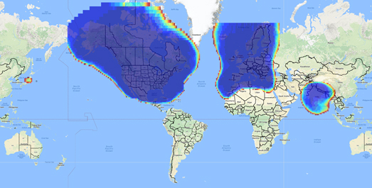
Space Based Augmentation Systems (SBAS) – known in North America as the Federal Aviation Administration’s (FAA’s) Wide Area Augmentation System (WAAS) – have been fully operational in one form or another for several years. The FAA’s incremental improvements to integrity, accuracy and reliability in WAAS have brought the system to a point where we have precision en-route navigation for aircraft, and we can also land aircraft using WAAS signals at thousands of airports in the US and in Canada.
Why not Mexico, which also benefits from the same WAAS coverage? More on that later, as we piece together the many parts of the complex SBAS mosaic.
SBAS precision approach coverage, May 2016. Graphic: FAA Tech Center, Lockheed Martin, GMV
Europe benefits from high-accuracy en-route navigation, and there are also hundreds of operational approaches using the European Geostationary Navigation Overlay Service (EGNOS) SBAS.
In India, the GPS Aided Geo-Augmented Navigation (GAGAN) system provides accurate en-route navigation and approach capability. However, ionospheric disturbance may limit some aspects of performance.
Japan established the Multi-functional Satellite Augmentation System (MSAS) SBAS, and has benefited from improved en-route navigation, but it’s possible that the more limited geographic distribution of GPS ground reference stations has restricted improvements to approach capabilities.
But what happened to the International Civil Aviation Organization (ICAO) concept from 2007, supported by all the ‘aviation-going’ countries of the world, that SBAS would evolve and eventually multiple national systems would provide coverage around the rest of the world, maybe even by 2016?
Countries in Asia, South America, Africa and the continent of Australia all appear to have looked closely into establishing their own SBAS, but nothing seems to have come out of these investigations. Technical issues, cost, and political obstacles have all hindered global SBAS progress.
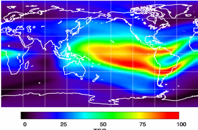
The ionospheric challenge. Graphic: GMV and Lockheed-Martin
Technical Issues. Ionospheric scintillation problems around the Equator seem to be at the root of most technical problems for SBAS. Getting to the required level of probable, bounded system error is hugely difficult. The iono disturbance ‘blob’ follows the sun around the Equator and wipes out any chance of satisfactory system performance when it passes over Equatorial countries.
As total electron count (TEC) increases, the ionospheric grid, which most SBAS use to predict ionospheric variation across their geographic area between fixed reference stations, well, it just doesn’t work anymore.
Cost. The capital cost of building a satellite-based augmentation system and the on-going cost of maintaining a bunch of geographically distributed reference sites, building and launching GEO satellites or renting transponders on someone else’s orbiting asset, establishing, operating and maintaining redundant uplink stations, redundant terrestrial data links, and setting up control systems that collect and create the SBAS uplink message — it all adds up. Millions and maybe even billions of dollars or equivalent, in total, have been spent by those select countries who could afford their own SBAS. Others named above have lesser financial resources upon which to draw.
Political Obstacles. One of the trickiest issues is sovereignty: the need for a country to control its own navigation and landing system. This has likely been the source of most resistance to more SBAS systems being set up and shared by bordering countries around the world.
For a large number of smaller countries, SBAS would only make sense if it was shared across a number of neighboring countries, but that means relinquishing sovereignty to some degree. In several regions of the world a number of geographically adjacent countries don’t particularly like each other, never mind thinking of such sharing/collaboration.
National sovereignty, by the way, isone of the main reasons that existing satellite navigation systems underpinning SBAS, such as Galileo, GLONASS, IRNSS (now NAVIC), QZSS and of course BeiDou have all been put in place.
Another problem with potential SBAS sharing across adjacent countries stems from responsibility for liability. Should something not work and an accident ensues from such a malfunction, who’s liable? Mexico seems to have adopted the view that since the US provides WAAS on what could be called an ‘as-is’ basis, then the potential liability issue seems to trump using the system.
Solutions? Technical issues with the ionosphere may soon be resolved by using dual-frequency L1/L5 airborne receivers that directly calculate their own ionospheric corrections, rather than using the computed SBAS iono grid. If we add in dual-frequency E1/E5a signals from Galileo, things start to get even better. New requirements and prototype equipment are already being developed for dual frequency multi-constellation airborne receivers. Airbus anticipates equipping aircraft with such receivers around 2025. Could this solve the SBAS technical issue for Equatorial countries?
ARINC (now a UTC/Rockwell Collins company) and SITA (in Europe) have been providing commercial aircraft with operational communications services on a pay-for-use basis for a number of years, and this is notarized as an accepted means of compliance within ICAO policy/requirements:
From ICAO Doc. 9161, Sec. 3.99: “A group of states or a regional organization might also undertake to operate the augmentation satellite service required, either by themselves or by contracting a commercial or government organization to do so on their behalf.”
ARINC en-route coverage. Graphic: ARINC
Aireon has partnered with NAV CANADA, the Irish Aviation Authority (IAA), Enav, NATS and Naviair, as well as Iridium Communications and Harris Corporation to provide real time ADS-B data (GPS position output from aircraft) to air-traffic control providers. Aireon’s payloads on the new Iridium NEXT Low-Earth Orbit (LEO) satellite constellation will receive aircraft ADS-B messages and relay them to Air Traffic Controllers in real-time.
There are 66 Iridium NEXT satellites in operation, with significant overlap and redundancy built into the system to enable this safety-of-life service to be provided on a pay-for-use basis to the aviation industry. We could at last know the location of every suitably equipped aircraft in the air, in almost real-time. The ICAO requirement is for an update rate of 15 minutes.
Inmarsat ADS-C is a similar service available to aircraft on a contracted, pay-for-use basis via Inmarsat GEO satellites.
Market Solutions. If a substantial company showed up with a worldwide distributed SBAS solution and offered it on a fee for service basis, why wouldn’t countries that are already accustomed to ARINC and SITA pay-for-use communications? The Aireon international aircraft tracking system, to be provided on the same basis, adds to the credibility of such a pay-for-use service.
So why wouldn’t these accepted services demonstrate to those countries concerned about control and national sovereignty that an SBAS service could be provided on this basis?
The liability for provision of service sits with the providers, so user countries/airlines would have someone to turn to about liability issues, and there presumably could be contract terms to provide system performance guarantees.
No huge capital costs, no system to construct, nor staff to operate or maintain, and yet a level of control similar to that which has been around for commercial aircraft communications for decades.
Would this be of interest to countries that have not yet jumped on the SBAS bandwagon? A definite ‘maybe,’ we could imagine? What’s not to like?
The punch line to all this is that Lockheed Martin and GMV (Spain) have teamed to challenge these non-SBAS countries with a solution which may appeal.
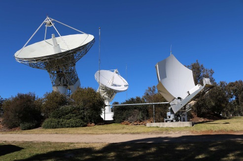
Uralla reference test site. Photo: Lockheed-Martin
To present convincing evidence that it would work, a dual frequency GPS (L1/L2) + Galileo (E1/E5a) reference site has been set up in collaboration with Geoscience Australia and Land Information New Zealand. The reference site is located at Uralla, New South Wales on Australia’s East Coast, where it gathers data demonstrating bounded errors within the operational range which could enable GNSS approach capability.
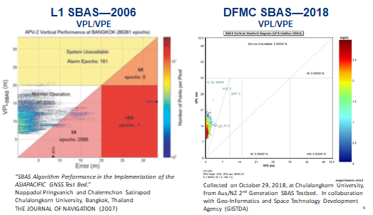
L1 (2006) vs. DFMC (2018) SBAS at Bangkok. Graphic: Lockheed-Martin, GMV
Another test site in Bangkok, Thailand has demonstrated that existing L1-only SBAS in this area cannot manage this performance (all current SBAS are L1 only), but that with dual-frequency multi-constellation (DFMC) GPS L1/L2+Galileo E1/E5a, the required performance limits could be met.
Lockheed Martin has also been using the Uralla uplink site to test the uplink and downlink of dual-frequency SBAS-like test messages.
The Moral of the Story. There are no miracles as yet, but interest in the pay-as-you-go SBAS concept appears to be growing, and the LM/GMV team continues to work to bring their approach to market.
A large number of countries could well benefit from the high accuracy, integrity and continuity of SBAS service if this all comes together.
The scheduled launch of the first GPS III satellite on December 18 was scrubbed, reportedly due to first stage liquid oxygen thermal limit constraints aboard the SpaceX Falcon 9 Block 5 launch vehicle’s first stage reaching safety limits. A second attempt on December 19 was later ruled out due to ongoing evaluations into the sensor issue.
The launch window may open again on Dec. 20.
This was to have been the first GPS launch aboard a SpaceX rocket, as well as the first SpaceX contracted U.S. National Security mission.
A Falcon 9 rocket awaits launch. (Photo: SpaceX)
The first GPS III satellite was originally scheduled to ride aboard a United Launch Alliance (ULA) Delta IV M+ rocket. ULA and/or its prime partners, Lockheed-Martin and Boeing, have conducted every GPS satellite launch since the start of the program. However, due to an assortment of issues variously involving delayed technology development and lawsuits regarding competitive bidding, the Air Force re-opened bidding for the contract as part of its Evolved Expendable Launch Vehicle (EELV) program — “evolved” signifying that the rocket can be recovered and reused.
Recycling Rockets. ULA did not bid on the re-opened contract, citing concerns over the selection process and potential risks with the anticipated lower launch cost. In 2016, the Air Force selected SpaceX to take over most GPS III launches.
SpaceX’s Falcon 9 for this launch will use a new first stage core, the B1054. Although it has re-use capability, it will fly in an expendable configuration this time, with no landing legs and no grid fins. It will be disposed of into the Atlantic Ocean after separation from the second stage.
In other missions, after the satellite-bearing stage separates from the rest of the rocket, the remaining core launcher fires additional fuel to return intact to land or to sea aboard an Autonomous Spaceport Drone Ship (ASDS), a converted barge awaiting in the Atlantic or Pacific Ocean.
New Generation of GPS. As attentive readers already know, GPS III SV01 is the first of an entirely new design of GPS satellite that will help the Air Force modernize today’s GPS constellation with new technology and advanced capabilities.
GPS III has three times better accuracy and up to eight times improved anti-jamming capabilities. Spacecraft life will extend to 15 years, 25 percent longer than any of the GPS satellites on-orbit today. GPS III’s new L1C civil signal also will make it the first GPS satellite broadcasting a compatible signal with other international global navigation satellite systems, like Galileo, improving connectivity for civilian users.
Lockheed Martin developed GPS III and manufactured GPS III SV01 at its GPS III Processing Facility near Denver. In September 2017, the Air Force declared the satellite “Available for Launch” (AFL) and had the company place it into storage. In 2018, the Air Force called up the satellite for launch and Lockheed Martin delivered it to Florida on Aug. 20. The Air Force nicknamed the satellite “Vespucci” after Italian explorer, navigator and cartographer Amerigo Vespucci.
GPS III SV01 is the first of 10 GPS III satellites originally ordered by the Air Force. GPS III SV03-08 are now in various stages of assembly and test. In August, the Air Force declared the second GPS III AFL and in November called GPS III SV02 up for 2019 launch.
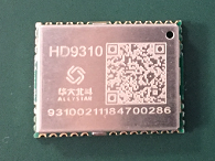
Allystar Technology Co. Ltd., headquartered in Shenzhen, China, has released a multi-band multi-GNSS chipset, the HD9310. The new product is based on the Cynosure III architecture integrating multi-band multi-system GNSS RF and baseband.
A multi-band, multi-system system-on-chip, it supports BeiDou-3 and is capable of tracking all global civil navigation systems (GPS, BeiDou, Galileo, GLONASS, IRNSS, QZSS and SBAS) in all bands (L1, L2, L5, L6), said Simon Sun, Allystar general manager.
Photo: Allystar Technology
Designed for high-precision applications, the HD9310 measures 5.0mm x 5.0mm. The architecture integrates floating-point arithmetic units based on ARM CortexM4, 160 KB RAM, 32KB backup RAM with VBAT, 386 KB embedded FLASH and peripheral interfaces UART, I2C, SPI, GPIO, CAN.
In terms of the manufacturing processes, it adopts a 40nm process and incorporates a variety of advanced design technologies, endowing it with very power consumption: less than 50mA.
The quad-flat no-leads package allows customers to reduce printed circuit board and bill of materials costs while reducing the number of peripheral devices. This chip supports CAN interface and can be widely used in vehicle management, car navigation, wearable devices, GIS data collection, precision agriculture, smart logistics, driverless, engineering survey and other fields.
“The HD9310 supports three options of RF setting — A, B, C — for product developers to quickly bring their ideas to the different application and markets,” added Shi Xian Yang, high precision project manager at Allystar.
Three available options for the HD9310 chipset. Graphic: Allystar Technology
Option A, focused on L5 band, L5/E5, maximizes measurement accuracy and improves multipath mitigation based on higher chip rate.
Option B is focused on L2 band, and suitable for relative position applications, for example, real-time kinematic (RTK), because worldwide continuously operating reference stations (CORS) commonly support L1/L2/L1OF/L2OF.
Option C is focused on the L6 band and is designed for PPP applications, receiving state space representation (SSR)-type corrections to be broadcast from satellites in the coming future, and supporting B3I already.
The HD9310 comes with built-in support for standard RTCM Protocol (MSM), supporting multi-band multi-system high-precision raw data output, including pseudo range, phase range, Doppler, SNR for any kind of 3rd party integration and application.
Module. Allystar Technology also has launched a multi-band multi-GNSS module, TAU1302, which integrates the HD9310 chipset and measures 12 × 16 × 2.3 millimeters.
With the features of small size, low power consumption (<50 mA), and ease of integration and mass production, HD9310 is suitable for high-precision applications such as vehicle management, car navigation, wearable devices, GIS data collection, precision agriculture, smart logistics, driverless, engineering survey and other fields.
Customer samples of the HD9310 chipset are available now.
Yury Urlichich, First Deputy Director General, Roscosmos. (Photo: Roscosmos)
By Yury Urlichich First Deputy Director General, Roscosmos State Space Corporation
The year 2019 will bring GLONASS users many new opportunities. Improving navigation services specifically at the user level, primarily assessed in terms of signal accuracy and availability, is our primary goal. Improving navigation accuracy is based on space system development, including both the orbital constellation (space segment) and ground control segment.
CDMA Signal
A Glonass-K2 spacecraft (SC) launch followed by flight testing will be the most important event in space segment development. This SC will enable navigation not only using legacy FDMA signals available for users for more than 35 years, but simultaneously with a full row of CDMA signals in all GLONASS frequency bands: L1, L2 and L3.
Currently the major navigation error contributors are the radio signal trajectory and the user terminal receiving environment. The new signals will allow lowering the hardware-dependent SC-user ranging error by an order of magnitude, reducing the influence of signal reflections from buildings, constructions and landscape (multipath effect), thus enabling their effective use for high-precision navigation with real-time errors below 0.1 m.
We are also finalizing in 2019 the newest edition of the GLONASS Interface Control Document containing recommended models for evaluation of tropospheric and ionospheric delays. Our forecasts show two times navigation accuracy improvement for users of these models.
High-Orbit GLONASS
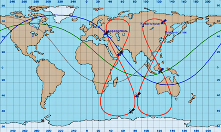
Improving signal availability is equally important. As large urban areas demonstrate growing use of navigation technologies, these users experience difficulties receiving signals from SC flying below the elevation angle of 25°. To provide a navigation solution in such environments, we will begin development of High-Orbit GLONASS in 2019.
High-Orbit GLONASS will consist of six SC distributed among the three orbital planes and forming two SC ground traces with 64.8° orbit inclination, eccentricity of 0.072, revolution period of 23.9 hours, geographical longitude of the ascendant angle – 60°, 120° (See figure below).
High-Orbit GLONASS — ground track in red. (Image: Roscosmos)
The new generation space segment will be populated with Glonass-B satellites designed on the proven Glonass-K platform, successfully providing services since 2012. Users will be offered the full spectrum of new CDMA signals in all three GLONASS frequency bands.
The first Glonass-B is planned for launch in 2023, with the full constellation of six SC to be deployed by the end of 2025, increasing by 25% the navigation accuracy in the Eastern hemisphere.
The satellite mass below 1,000 kg allows Angara-A5, the new Russian heavy launch vehicle, to perform a dual launch from either Plesetsk or Vostochny launch sites.
Much attention is being paid to the signal characteristics’ stability throughout the whole system lifecycle. For this purpose, ROSCOSMOS developed the GLONASS Monitoring and Performance Assessment System for civil users, including the distributed network of monitoring stations abroad, and dedicated radio telescopes capable of analyzing the navigation signal structure and power on the Earth’s surface.
Currently the planned user range error (URE) for signal in space is 1.4 m. Feb. 26, with URE of 1.13 m, became the best day of the ten-month long monitoring in 2018. Moreover, this value tends to decrease as Glonass-M satellites operating beyond their guaranteed life period are being replaced. For instance, on Nov. 3, Glonass-M satellite No. 57 launched, replacing No. 16 after almost 12 years of operation in orbit.
As already mentioned, the Glonass-K2 is planned for launch in 2019. Compared to Glonass-M and Glonass-K satellites, Mission Definition Requirements for Glonass-K2 define URE to be 0.3 m, qualitatively improving GLONASS user performance.
The new on-board frequency standard based on passive hydrogen maser (PHM) will also contribute to better performance. This PHM is undergoing its ground tests and will be installed onboard the SC by the end of the year. Its relative 24-hour stability of better than 5×10-15 ensures the required URE.
Following the 2018 Public Interface Control Working Group (ICWG) in September, the GPS Directorate invites additional public comments on the following Proposed Interface Revision Notices (PIRNs) due to the nature of changes since the June 2018 review.