Guided by the leadership of the U.S. Air Force, and now the Space Force, for four decades GPS has supported all aspects of military operations, from precision guided munitions to search and rescue missions. GPS, however, is also ingrained in our economy, enabling a wide range of civil and consumer applications, including aviation, precision agriculture, construction, banking and public safety.
It’s easy to take GPS for granted, because we use it every day and it works so well. But what if someone interfered with the reliability and accuracy of GPS on which we depend? A 2019 study sponsored by the National Institute of Standards and Technology (NIST) estimated a $1 billion-a-day impact to our economy if GPS were lost.
Regrettably, the Federal Communications Commission (FCC) rolled the dice on this scenario in 2020, when it approved an application from Ligado Networks, a satellite communications company, to repurpose satellite spectrum in the L-band for high-power terrestrial use.*
Ignoring the warnings of a broad coalition of stakeholders, including U.S. federal agencies, congressional leaders and businesses, the FCC moved to open the traditionally “quiet neighborhood” used by satellite-based navigation services like GPS to ground-based signals that are billions of times more powerful.
The FCC itself was clear on the risks when it issued the order, and so it’s no surprise they explicitly required Ligado to “repair or replace as needed any U.S. government GPS devices that experience harmful interference from Ligado’s operations.” At the time, however, a key constituency was excluded from these protections: the millions of U.S. consumers and businesses who rely on accurate, reliable GPS signals.
In fact, 99% of the more than 900 million GPS devices found in the United States are used by the private sector, consumers, as well as state and local governments. Under the FCC’s order, first responders, pilots, municipal governments, farmers and countless other GPS users have been left on the hook for costs associated with Ligado’s disruptions.
On June 22, a bipartisan group of senators, led by Sen. Jim Inhofe (R-OK), took a critical step toward addressing this inequality by introducing the Recognizing and Ensuring Taxpayer Access to Infrastructure Necessary for GPS and Satellite Communications Act (RETAIN Act). A bipartisan House companion bill was subsequently introduced on July 22. This carefully balanced proposal ensures that Ligado, as the license holder and source of interference, is the one responsible for paying the costs to upgrade or replace affected GPS receivers used by consumers and businesses.
Across the country, GPS is woven into the fabric of the economy and people’s everyday lives. More than 100 million vehicles are equipped with a GPS receiver, and trains and aircraft use GPS to move people and goods. Our farms depend on GPS to increase crop yields and reduce waste. Similarly, with accurate and reliable GPS,
America’s bridges, and roads are being built more accurately, improving safety, and reducing construction times.
The RETAIN Act also protects municipal fire crews that depend on GPS for improved situational awareness and to speed response times to people in danger. In the critical moments between a 911 call and the arrival of firefighters, seconds matter. An unexpected loss of GPS could therefore be catastrophic. This is why GPSIA and more than 100 industry organizations and companies are supporting the RETAIN Act.
The RETAIN Act also considers the thousands of businesses that are showcasing their grit and ingenuity to bounce back from the COVID pandemic. Many of these companies are implementing GPS-enabled solutions, including app-based delivery and contact-tracing tools to increase efficiency and protect the safety of their employees.
The GPS Innovation Alliance, an organization committed to furthering GPS innovation, creativity and entrepreneurship, is grateful to these leaders in Congress who are standing up in support of GPS users.
Consistent with the terms of their litigation settlements with Ligado, Garmin International Inc. and Deere & Company do not affirmatively endorse or oppose the deployment of Ligado’s proposed mobile communications network. To the extent this op-ed discusses Ligado’s deployment of its proposed 5G mobile communications network (or any interference therefrom), GPSIA is not authorized, and does not purport, to speak for Garmin and Deere.
Soon, global navigation will no longer suffice. Humanity is preparing to return to the Moon after more than half a century. U.S., European, Chinese, Indian, Japanese and Russian governments and companies want a slice of the “eighth continent.”
NASA’s Artemis program, which aims to put astronauts on the Moon’s south pole in 2024, will explore more of the lunar surface than ever before. Robots and humans will search for, and potentially extract, resources such as water, which also can be converted into other usable resources, including oxygen and fuel.
Astronauts searching for spots where robotic spacecraft have pointed to the ice on the lunar map and for equipment sent on ahead of them will need precise navigation guidance. So will astronauts and ground controllers operating the Gateway outpost in Moon orbit and the Orion spacecraft. This will require extending the reach of our Earth-centric positioning, navigation and timing (PNT) systems to cover our planet’s nearest neighbor.
A permanent and reliable source of PNT on the Moon will reduce the amount of gear each mission will have to develop and carry, making more funding and rocket-lift capabilities available for scientific equipment. It also will free bandwidth on NASA’s communications networks, which have historically provided navigation services near the Moon.
NASA and the European Space Agency (ESA) are laying the foundations for this navigation system. Their efforts include the development of a special receiver able to pick up GPS signals that, already very weak on Earth, are extremely so on the Moon; NASA’s LunaNet communications and navigation architecture; ESA’s public-private Pathfinder satellite navigation and communication mission, due to launch into lunar orbit by the end of 2023; and ESA’s Moonlight initiative, which will establish lunar communication and navigation services.
Studies already have proven that it is possible to navigate between Earth and the Moon, as well as on the latter’s surface, using the side lobes of the signals from GNSS satellites. In 2023, the Lunar GNSS Receiver Experiment (LuGRE), developed in partnership with the Italian Space Agency, will demonstrate and refine this capability on the Moon’s Mare Crisium basin. NASA will use data gathered from LuGRE to refine operational lunar GNSS systems for future missions.
Besides the low signal power, other challenges to using GNSS satellites for Moon navigation include geometry, with all the signals coming from a relatively small portion of the sky; the fact that in polar regions the Earth would be low on the horizon and therefore GNSS signals could easily be blocked by hills or crater rims; and the complete occultation of the signals when moving beyond the side of the Moon always facing Earth. Meeting this last challenge will require at least a couple of Moon-orbiting satellites. (Artificial satellites orbiting our planet’s natural satellite as a supplement to the artificial satellites orbiting our planet…)
The Moon will be our steppingstone to Mars. I bet it will not be long before the Institute of Navigation establishes a Planetary Navigation division!
Earlier this year, we looked back at 2020 and reviewed how surveying has dealt with the worldwide pandemic while adapting to the new tools and technology being created. We discovered the need for surveyors did not diminish during this crisis, and in many places the demand has gone up significantly. Instruments, computers and measuring methods continue to increase in capability and complexity to help with the shortage of qualified field crews, yet we still need to expand our efforts to find the next generation of surveyors.
How do we find those future geospatial experts, data collectors and surveying professionals? The answer is right under our noses, and our current group of practitioners needs to get the word out.
What is the word, you ask?
Technology.
Younger generations understand technology better than most practicing surveyors. New devices, methods and operations are being invented at a fast pace, and our best and brightest should be considering using that technology in a rewarding career. Before we make the big pitch to them, however, we should refresh our understanding of recent surveying history to better understand why technology is a good thing.
How did we get here? A short historical look at measuring
The measurement methods, devices and instruments used by surveyors have radically changed in the past 50 years, and we have covered their evolution in past columns (Survey SceneMay 2016, May 2017 and Sept. 2019).
Instruments and devices used by surveyors vary in their function and output of information. Some are used to physically measure the distance from a stationary point to another, determine horizontal and vertical angles at a specific location, or determine grade differentials between various points. Other instruments are used to determine horizontal or vertical positions to establish locations and elevations. All these instruments are being used to gather positional data on any number of items, but the quality of the information may vary depending on the technology and method used. How?
Devices and methods for measuring distances
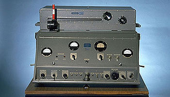
AGA Geodimeter NASM-2A. (Photo: NOAA)
Tools for measuring distances have been around for centuries. The Egyptians are famous for their “rope stretchers,” while early surveyors in Europe and the New Colonies were known to use the Gunter’s chain and a measuring wheel. In the early 1800s, steel tapes were invented to replace the chain. These measuring tapes continued to evolve well into the 20th century with varying metals, fiberglass and nylon-coated plastics.
In the mid-20th century, scientists and physicists began to experiment using light waves as a means of measuring terrestrial distances. These experiments led to the development of the first electronic distance meter (EDM), commercially produced by the Swedish company Svenska Aktiebolaget Gasaccumulator (AGA) in the early 1950s. Other methods of electronic measurement, including microwave and infrared wave technology, were also developed in the years following the introduction of the lightwave EDM.
For many years, the EDM was used independently from transits or theodolites to measure long distances. For those who needed to consistently measure long distances, the invention of the EDM was not just a time saver, but also provided much higher accuracy than manual measurements.
Other technologies were developed in the latter part of the 20th century, introducing the surveyor to laser scanning, but we can defer this topic until later in this column.
Devices for measuring angles
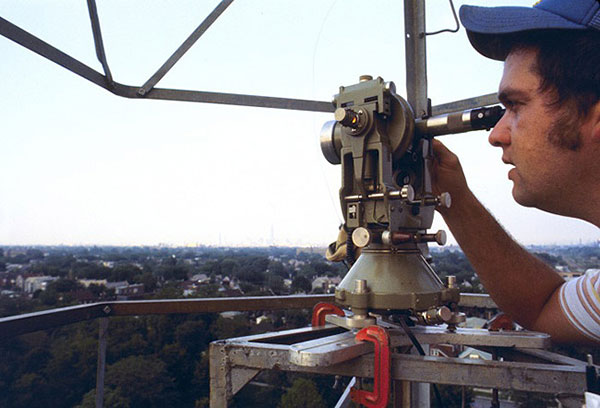
The T3 theodolite was introduced in 1925. With its 10.5-inch telescope, this theodolite had a range of up to 60 miles. It saw heavy use between 1952 and 1984. (Photo: NOAA)
The surveyor, like the astronomer, has consistently been at the forefront of developing optical instruments. The key has been combining high optical quality with a means of measuring horizontal and vertical angles within the instrument. The creation of the theodolite and the transit revolutionized the ability of the surveyor to accurately measure angles and apply trigonometric functions to determine mathematical computations. In addition, the surveyor’s compass was also developed to assist with angle measurement — with less accuracy but greater flexibility.
By the 1920s, optical theodolite technology was rapidly improving through the work of Switzerland’s Heinrich Wild. Beginning with the T2 and T3, these instruments provided accuracy and precision not previously available to the surveyor. Other manufacturers followed suit with similar instruments for the next several decades and were used in conjunction with the EDM for larger surveys. Anticipation grew with the competition to see which instrument company could marry the theodolite and the EDM into one easy-to-use, yet accurate, optical instrument.
Introducing the total station
By the late 1960s, technology had firmly entered the surveying world with a few electronic advancements. In 1968, Zeiss — a German company known for its lenses and optical systems — produced the first known tachymeter, combining a theodolite with an electronic distance meter. The tachymeter became better known as the total station, as it was capable of measuring angles and distances in one instrument. While somewhat crude and hard to use, the Elta 14 total station introduced the world to a future generation of surveying instruments that would revolutionize the field.
In the course of a few years, several manufacturers developed their own total stations. The biggest hurdle was combining the optics of the scope with the measuring axis of the EDM. By the end of the 1970s, most total stations were coaxial, therefore measuring angles and distances was done with one sighting.
Robotics were introduced in the early 1990s, with two servo motors to drive the horizontal and vertical movements of the total station. These movements were controlled remotely by the tracking system connected to the prism pole and data collector. Not requiring a human being to remain stationary and manually operate the total station provided cost savings and additional efficiency for the field crew.
Positions, everyone! Positions!
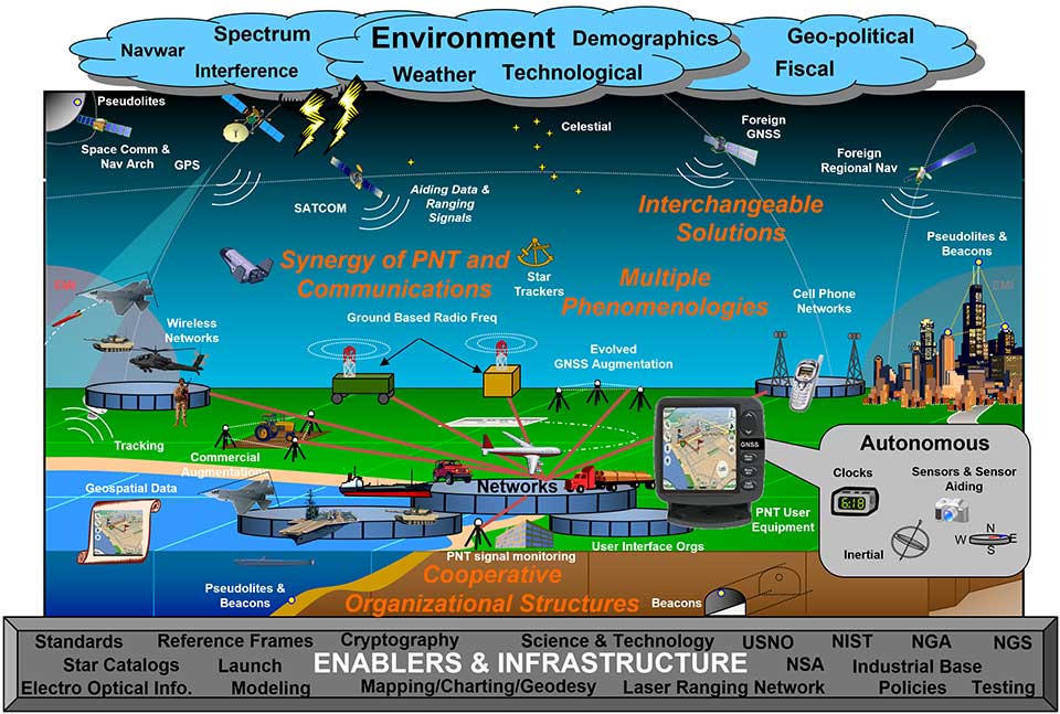
U.S. National PNT Architecture. (Graphic: U.S. Department of Transportation)
Positional measurement has revolutionized not just the surveying profession, but a large portion of everyday tasks as well. From monitoring travel times for your commute to providing your food-delivery driver with your location, position determination is the key element to these services. Satellite navigation is now the primary technology used for positioning, navigation and timing (PNT) and a big part of most aspects of surveying.
Remote sensing
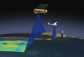
Here is where we can discuss laser scanning and other remote sensing technologies. Remote sensing is the science and technology of gathering data from a distance. Traditionally this has been mostly done from aircraft, satellites and vessels. However, technology has expanded so that most practitioners now consider the use of laser scanning, lidar, photogrammetry, hyperspectral cameras, bathymetric sonar and simultaneous localization and mapping (SLAM) to be included in the category. Keep in mind that all these technologies are types of measurements; they are not the vehicle or instruments used for the measurement.
Image: NASA
These various sensor types can collect millions of data points in a short amount of time. While surveyors are adapting to working with point clouds and gigabytes/terabytes of data, it is a radical departure from our recent past using only total stations and GNSS receivers. Significant advancements in computer processing, data storage and programming have simplified the manipulation of point clouds, but they remain a challenging task for even newer surveyors to tackle.
Autonomous vehicles
Hobbyists have been building (and crashing) model airplanes and helicopters for many years. Most of the public does not realize that the big advancement in remote-control aircraft was the introduction of GNSS technology into the flight system. Sure, we all have GNSS receivers in our phones, but now to be included in our toys? This somewhat simple addition has turned unmanned aerial vehicles (UAV) into a revolutionary tool for several occupations, not just surveyors. More control and stability of the UAV means expanded uses for emergency personnel, utility providers, parcel delivery and much more. Being able to program a specific flight provides the UAV user with higher accuracy and precision, but it takes away the element of human control.
Image: Department of Transportation
Another vehicle gaining market share is the unmanned surface vessel (USV), used for performing hydrographic surveys. Like its UAV cousin, the USV is autonomous and is programmed to follow a specific route for greater accuracy and precision. Because of the shallow draft of a USV, it can be used in many areas deemed inaccessible by manned vessels.
An additional aspect of newer technology working with autonomous vehicles is collision avoidance systems. These systems have been implemented on newer UAVs and continue to improve, allowing their the use in tighter confines and spaces. By having a radar-based avoidance signal surrounding the entire UAV, collisions become less likely.
Geofencing is another advancement being implemented into more UAVs to help keep them from intruding into unauthorized spaces, by programming into their computer specific geographic areas that are off limits. UAVs are often also programmed to return to its takeoff location under certain circumstances.
Other technological advances to consider
Image: State Department
How much technology do you have in your home and office? Probably more than you realize. While one may immediately think about a smart speaker or home automation system (Alexa, Echo, Nest, etc.), other components offer simple yet productive solutions.
Remote control systems enable you to check whether your doors are locked and your garage door is shut. If not, a touch of a button does the job. Motion sensors enable you to detect intruders around and inside the house, of course. Environmental sensors now monitor for water leaks, moisture and gas/carbon monoxide and provide alerts. How about home automation that utilizes robotic technology? The Roomba vacuum, automatic pool cleaners, and even window washing systems activated when dirt is recognized on your exterior windows are just some of the robotic devices in the modern home.
Precision agriculture utilizes autonomous vehicle control to increase the precision of planting, spraying and harvesting crops. This increase in efficiency has led to higher yields and lower operating costs for the equipment. Another market starting to see more interest is the robotic lawn mowers that functions like the Roomba vacuum. While significantly more expensive than manual mowers, they offer features that can be considered for trade-offs for your time. Depending on your location and needs, they can be set on timers to run day or night and return to base when their battery runs low.
Adapting today’s technology to tomorrow’s surveying tasks
Another relevant technology that does not fit into any of the topics above is the inertial measurement unit (IMU). These sensors are now routinely paired with GNSS receivers in UAVs to help them compensate for pitch and roll. Because of their small form factor, IMUs will increasingly be incorporated into other measurement devices.
It is also safe to say that more handheld devices and smartphones will include lidar scanning capability, as the iPhone 12 Pro and iPad Pro already do. Application and software developers are writing code to make use of data from these devices, so plan on other hardware makers following Apple’s lead.
Voice and motion control will continue to be integrated into data collectors and workstations. By minimizing physical entries into an input system, computers will begin to recognize patterns and automate procedures to increase efficiencies. Programmable voice commands during field data collection will activate various procedures (for instance, specific roadway cross sections or curb island locations) and walk the user through a predetermined set of steps. The possibilities are endless, but we should prepare to take advantage of the technology.
Enticing future generations into a geospatial career
Image: Digital.gov
A geospatial career is so much more than just being a surveyor. Our profession needs bright minds who see the world differently. What does that mean?
Most surveying and mapping tasks used to produce 2D deliverables on paper. Today’s geospatial technicians fly UAVs, use point clouds, draft existing conditions in 3D, and analyze data for future applications. By applying what they are learning with new devices, technologies and software platforms, our younger generations can help the surveying and geospatial profession evolve into a data-rich environment that helps facilitate change for our planet. These efforts can help with climate change, provide better data for our communities, and bring societies back together.
Our profession is much more than gathering data; it is helping to make our world a better place through better data analysis and knowledge. Who would not want that?
Alternative. Complementary. Backup. Co-primary. These are some of the terms used to refer to sources of positioning, navigation and timing (PNT) data other than GNSS satellites.
The four current GNSS constellations — supplemented by two regional ones and by public and private augmentation systems — have firmly established themselves as the primary source of PNT data by virtue of their accuracy, reliability, global coverage and ubiquitous use. Yet, this widespread dependency on them — especially on GPS — coupled with their well-known vulnerabilities to jamming, spoofing, other RF interference, multipath, solar flares and space debris (see page 10) — make the development of alternative sources of PNT data imperative. In fact, the U.S. Congress has repeatedly mandated it.
Typically, when talking about alternative PNT, we are referring to sources of PNT data that either were not originally developed for navigation purposes — such as television broadcast towers used as “beacons of opportunity” — or that use a higher broadcast power or a different frequency band than GNSS. They include legacy systems and new versions of legacy systems, such as eLoran.
“The only replacement for a GNSS is another GNSS.”
Other non-GNSS sources of PNT data have a wide range of benefits, limitations and costs, including infrastructure requirements. Most provide only the P and the N, or only the T, in PNT. Inertial systems, for example, once initialized can provide positioning and navigation, but need to be periodically re-initialized to compensate for their drift. Therefore, while excellent for maintaining the navigation solution during short GNSS outages and very helpful in identifying false GNSS measurements due to multipath, they are no replacement for GNSS. Cameras, radar and lidar, while often excellent sources of relative positioning, cannot provide absolute positioning.
It is even harder to replace GNSS when it comes to timing. Already enormously important in synchronizing the Internet, financial transactions and broadcasting, this service is essential to the development of complex new systems, such as integrating autonomous and legacy vehicles into digital traffic networks.
As in other human enterprises, the key to resiliency in PNT is diversity: a mix of systems based on sufficiently distinct technological foundations so that a threat to one does not imperil the other ones. Additionally, having a variety of available sources of PNT data will enable users to choose the ones most suited to their platforms.
However, we need to distinguish between technologies that can assist GNSS, such as inertial, and those that could substitute GNSS. I agree with Chuck Schue’s definition of the latter (see cover story, page 28): “an alternative PNT solution is one that is readily available; provides an easy and seamless transition to/from the primary or other alternatives; allows continuity of operation at a possibly degraded, yet usable, level of accuracy, availability, integrity or continuity; and is dissimilar enough from the primary solution to withstand the effects that might be affecting it.”
Ultimately, Schue pointed out to me, “the only replacement for a GNSS is another GNSS.” So, let us stop referring to systems that are not true substitutes for GNSS as “alternative PNT.” Complementary is a more appropriate adjective.
What is the most promising development or project in alternative PNT?
John Fischer.
“PNT from LEO (low-Earth orbit) satellites offers the most immediate alternative to GNSS because the signals are ~30 dB or more stronger, reducing jamming vulnerability. With these new constellations being launched to improve communications, PNT services can ‘piggyback’ on the secure two-way links and avoid spoofing attacks as well. Geometric dilution of precision (GDOP) will not be a problem in these large second-generation constellations with dozens of satellites in view. Wide bandwidth links should yield accuracies to rival GNSS. There may be subscription fees to get this added resiliency, but nothing worthwhile is ever free.”
John Fischer, Orolia
Bernard Gruber
“It depends on the application. I believe that alternative PNT, and specifically systems that complement GPS/GNSS, will continue to drive forward at a very rapid pace. Quite frankly, the ‘affordability of GPS’ from a commercial and military user business case was impossible to ignore for years. Today, the threat to GNSS signals is very real. History illustrates that ‘alternative’ systems that employ environmental data (magnetic, celestial), radio navigation (Loran, VOR), sensors (gyros, accelerometers), seekers (SAL, EO/IR) and IMUs all have new and promising developments today.” Bernard Gruber, Northrop Grumman
Thibault Bonnevie
“Inertially aided GNSS solutions are now mature and provide excellent navigation performance in many challenging conditions. On the research side, there are many exciting alternative PNT projects ongoing. RF-based solutions, such as Bluetooth/Wi-Fi or LEO satellite ranging, give promising results but are still subject to jamming or spoofing. Just like GNSS. Vision-based SLAM is probably the most exciting technology as it enables navigation in a wide range of situations and does not rely on any kind of infrastructure. It only requires low-cost sensors to be operated.” Thibault Bonnevie, SBG Systems
Ismael Colomina
“We all know that predictions are hazardous, especially about the future. This said, I confess that I am particularly interested in the technical, regulatory and commercial development of the LEO-based PNT technology with either dedicated constellations, like XONA’s Pulsar, or broader scope ones such as Iridium Next, Starlink or Kuiper. While GNSS has progressed tremendously in recent times — it plays a large role in the navigation of autonomous vehicles — it is still vulnerable to intentional or unintentional jamming. Integration of LEO-based PNT with current GNSS and other motion sensors appears to be a fascinating field ahead of us..” Ismael Colomina, GeoNumerics
The stated goal of a recently published RAND study was to answer a question from Congress about what should be done to back up and complement the nation’s GPS. One of its findings was that the government should consider investing in a national timing network.
Yet the study’s report emphasizes the wrong things, according to some. So much so that it is working against establishment of a timing network to reinforce GPS.
Report Misleading
“The main thrust of the study’s report is that we don’t need another GPS-like, system,” said Pat Diamond. “That has always been fairly obvious. I don’t know anyone who has ever advocated for duplicating GPS.” Diamond is CEO and founder of a network company and is a member of the president’s National Space-based Positioning, Navigation, and Timing (PNT) Advisory Board.
“By pounding so hard on the ‘don’t duplicate GPS’ drum, RAND hides its more important findings,” he said. “The public message comes across as there is no need to do anything.”
Diamond thinks the study should have better highlighted the things the federal government should do. “That is really the question Congress wanted answered,” he said.
RAND’s study supports four federal initiatives that “… appear to be cost-effective or close to cost-effective.” Included are a “timing-only” GPS-backup and support of high performance “geographically limited” systems.
Timing Essential, GPS Backup Needed
Cover: NSTAC
GPS timing signals are used in a wide variety of technologies including cell phones, IT networks, digital broadcast, first responders’ hand-held radios, and to synchronize electrical grids. Yet these signals from space are weak and easily disrupted.
A timing backup for GPS is also a long-standing recommendation of the president’s National Space-based PNT Advisory Board.
“There are few things more important to tech infrastructure today and tomorrow than timing,” according to Marc Weiss who was a lead researcher at the National Institutes of Standards and Technology for 35 years.
The RAND study was a cost-benefit analysis, which some have argued was not the best approach.
“Cost-benefit is always tricky,” says Greg Winfree, Director of the Texas Transportation Institute. “There are always a lot of assumptions. Small changes to any of the inputs can radically change the outcomes.” Winfree led civil PNT efforts during the Obama administration as an official at the Department of Transportation (DOT).
“One of my big concerns is that GPS is so important to so many things in America, that it is one of the most attractive targets for our adversaries. At least one alternate PNT that most people can access takes the bullseye off GPS,” Winfree said.
Scott Pace, director of the Space Policy Institute at George Washington University (GWU) agrees a diversity of PNT sources is important. At a recent GWU event, Pace commented having an alternative to GPS will contribute to national security and improve global stability. It will “lower the pressure on us to escalate and respond” should GPS satellites be damaged, or services disrupted. Pace was the Executive Secretary of the National Space Council in the Trump administration.
In the book The Russia Trap, author George Beebe has similar concerns, citing the lack of a backup for GPS as a technology resilience gap. Russia, China, and Iran all have terrestrial backups for PNT signals from space while the United States does not. Beebe says this is a weakness that can be exploited and could lead to an escalating series of exchanges resulting in all-out war.
Government Investment in Location Services
The RAND study suggestion for the government to invest in highly accurate PNT services in some limited geographic areas cited emergency responders’ needs for precise location. Federal investment will likely be required, it says, as commercial entities cannot make a business case everywhere service is needed.
GWU economics professor Diana Furchtgott-Roth has written that the federal government needs to provide a complement to GPS. She served as a Deputy Assistant Secretary at DOT from 2019 to 2021 leading civil PNT issues for the government.
“Without federal participation, commercial providers won’t ensure adequate resilient services for everyone. Some sectors, such as finance, will have it, but others won’t. This is a matter of national and homeland security. The RAND report did not emphasize this sufficiently.”
Questionable Timing and Motivation
“This is a particularly bad time for a confused message,” said a congressional staff member speaking about the RAND study. “Congress mandated a timing backup for GPS in 2018, though the project was never funded. There is real momentum this year to provide that funding, but the way this study reads works against that.”
Others see the structure of the study’s report and the timing of its release as a deliberate effort to derail budget negotiations. One retired Department of Homeland Security (DHS) official sees a pattern but is at a loss to explain the motivations behind it.
“RAND’s study was completed in 2019, and it was used as the basis for a DHS report to Congress in April 2020. But DHS didn’t tell Congress about RAND’s findings on a timing network and other actions the government should take,” they said.
“The study being made public now saying ‘do not back up GPS’ smells like a deliberate attempt to derail funding for the timing system. Something two presidential advisory boards, telecom leaders, RAND and so many others agree is needed.”
“Why would someone want to do that?” they asked. “Why would they want to keep America’s PNT so much weaker than China’s, Russia’s, and those of other countries?”
There is a lot of UAV action taking place this month. An anti-drone defensive system is being trialed by the U.S. Department of Homeland Security (DHS). DJI drones get the green light again for use by government agencies. The U.S. Navy/Boeing refuel an F/A-18 aircraft using a drone, and the Mars helicopter drone has a non-fatal in-flight problem.
DJI drones cleared for government use
There’s good news for operators who might have been scared away from using drones manufactured by Chinese company DJI. Two “government” models have now been cleared by the Pentagon for use by agencies who had previously been instructed to cease and desist operating them. The Matrice 600 Pro and the Mavic Pro government models were cleared, because “no malicious code or intent” was found. These types of drone are now “recommended for use by government entities and forces working with U.S. services.”
DJI Matrice 600 Pro (Photo: DJI)
The drones have been modified from standard models to provide a customized control application, prevent automatic software updates being applied without user approval, and implement an operational control-zone capability.
The U.S. Interior Department was behind the modifications, with the objective of resuming use of its grounded fleet of more than 500 DJI drones. They may need them again soon for forest-fire monitoring — it’s the season again. Allegations of potential “sharing of data” with the Chinese government were previously investigated and apparently debunked by Booz Allen Hamilton, in a report released in June 2020. Now the Pentagon seems to affirm these earlier findings.
Nevertheless, DJI remains on the Commerce Department’s don’t-buy list, and the Justice Department has banned agencies from buying foreign drones that could be vulnerable to tampering with data, or otherwise might be a threat to the U.S.
DHS trials anti-drone system
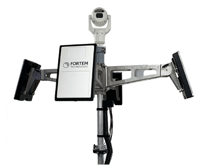
In recent “bad-drone” incidents, people have tried to smuggle contraband into prisons, flown into landing flight paths at airports, and even successfully inflicted significant damage on oil storage facilities in Saudi Arabia — never mind a failed assassination attempt in Venezuela. And with illegal immigration and drug smuggling becoming crisis issues, DHS has decided that its probably time to build a level of protection at U.S. borders. A trial is now scheduled at the quieter and more orderly Canadian border so that DHS can fully focus on evaluating the Fortem SkyDome system.
TrueView radar detects and calculates the location and trajectory of hundreds of airborne objects quickly and accurately. (Photo: Fortem Technologies)
Bad actors attacking a facility using a drone, sometimes with explosives strapped to it, have set their target as a waypoint and switched off the radio control link. The drone then carries on to its target, without fear of radio “sniffer” detection systems picking it up and jamming the control link.
Fortem built a drone defense system that uses radar for “RF silent drone” detection. Not only does the Fortem SkyDome system detect unwanted intruder drones, but it also can send out a DroneHunter UAV which hones in on and fires a net to capture, immobilize and bring back the offending drone so the defenders can investigate the attack.
Boeing UAV refuels F-18 fighter aircraft
Boeing is engaged in development of an unmanned tanker vehicle for the U.S. Navy. The company has built and flown the first test drone, known as Stingray MQ-25 T1. Boeing has another seven unmanned refueling tankers on order. T1 is the first test article for the program. Following a number of successful initial handling, control and envelope extension test flights — including several with the Navy refueling pod installed under the T1 left wing — fuel was loaded, and on June 4, a Navy F/A-18 Super Hornet fighter aircraft accompanied the T1 into the air on another test flight.
T1 Stingray refuels a Navy F/A-18. (Photo: U.S. Navy/Boeing)
The F/A-18 flew close to and maneuvered around the drone for some time, and when the pilot and test managers concluded that both were in joint, controlled, stable flight, the MQ-25 was commanded to extend the refueling pod hose and drogue. The F/A-18 normally refuels in the air from another F/A-18 configured with the same refueling pod and refueling boom, so the actual transfer of fuel which then took place was somewhat commonplace for the F-18 pilot, save that the slipstream buffet was probably less significant. Nevertheless, this was the very first time that a Navy aircraft has been refueled by an unmanned aircraft.
After further MQ-25 T1 test flights, the tanker-drone will be transported to Norfolk, Virginia, for deck handling trials aboard a U.S. Navy carrier later in the year. The MQ-25 Stingray is planned to take over this airborne refueling work which is currently handled by other F/A-18s, freeing up the fighter aircraft for operational fighter missions.
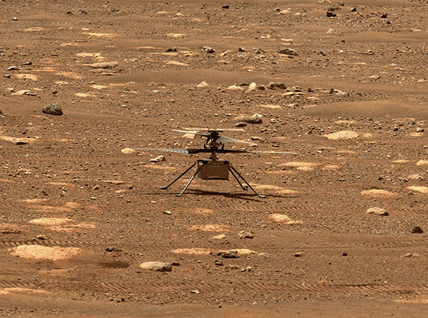
Mars drone flight experiences navigation anomaly
On May 25, the Mars drone Integrity had been commanded to take its sixth longer, higher flight. Like a good little tech package on the end of a 220-million-mile distant signal, Integrity did as it was told. However, after around 490 feet in the Mars atmosphere, Integrity started to change speed and dramatically oscillate back and forth. Even so, the UAV managed to complete the transit to within about 16 feet of the new intended parking spot.
NASA analyzed the data sent back from the drone through the Perseverance rover. NASA discovered that the flow of images from the navigation camera had been disrupted by a missing image, and the time-stamps for the images had become incorrect.
Integrity sits safely on Mars following an in-flight anomaly. (Photo: NASA)
Integrity’s navigation system is fed by an inertial measurement unit with images from the nav camera, so the time-stamp discrepancies between what the camera was saying and what the IMU was saying gave it an unforeseen issue to resolve. The resultant bucking in flight was an effort to resolve the data time differences. Images are not used in the landing phase, so the oscillations ceased as the rover descended, and the landing was as graceful as usual.
Fortunately, it appears that Integrity has not been damaged, and NASA is working to send the little drone on further scouting missions for its companion rover. NASA’s website indicates that the drone should have flown again on June 6, but right now there doesn’t seem to be any further evidence that a flight did or did not take place.
Summary
The testing that the Pentagon has done on a couple of models of DJI drones appears to have cleared them of possible malfeasance, but otherwise the report is classified. I wonder what secret science DOD used to detect/eliminate possible illicit communications with China by the drones? And it’s high time everyone realized that these “drone -thingies” can also be used to hurt us — as new technology in the hands of people who do not wish us well almost always can.
This month I discovered that Navy F/A-18s could fly further by hanging refueling pods on other F/A-18s, thereby taking the tanking aircraft out of the regular training and combat rotation. I’m glad we’ve got a drone alternative coming that must cost a lot less and also will free up fighting assets.
Finally, it doesn’t seem that we have to worry the Mars helicopter is too broken to keep seeking the best route for the rover. There were enough margins in the navigation algorithms that the little guy didn’t wreck when the image processing hiccupped. Let’s get flying again, NASA!
The April column also highlighted one of NGS’ four use cases – “Use Case 1: Flood Mapping.” The case study discusses the Elevation Certificate (CE) Example, Flood Insurance Rate Map (FIRM) and Flood Insurance Study (FIS).
The column highlighted the potential effects of subsidence on published heights in the Houston region, which implied that most of the published heights that are based on older surveys in the region are not current or accurate.
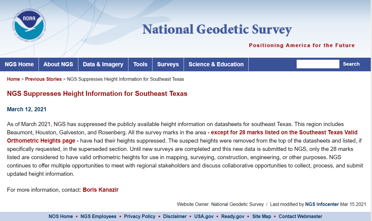
This column will provide more details of the suppression of heights in the Southeast Texas region, and potential effects of crustal movement on published heights in other regions of the United States.
NGS announcement that it suppressed height information for Southeast Texas. (Image: NGS)
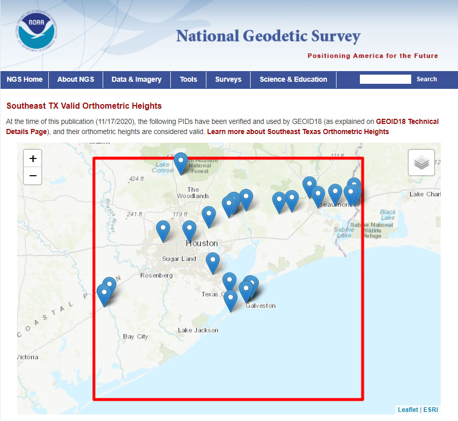
According to NGS’ announcement, only 28 marks will have publicly available orthometric heights on NGS datasheets in Southeast Texas.
The “Link to Map: SE TX Valid Ortho. Heights” button provides the benchmarks available to users (see the box titled “Link to Map SE TX Valid Ortho Heights”). The website provides links to the published stations.
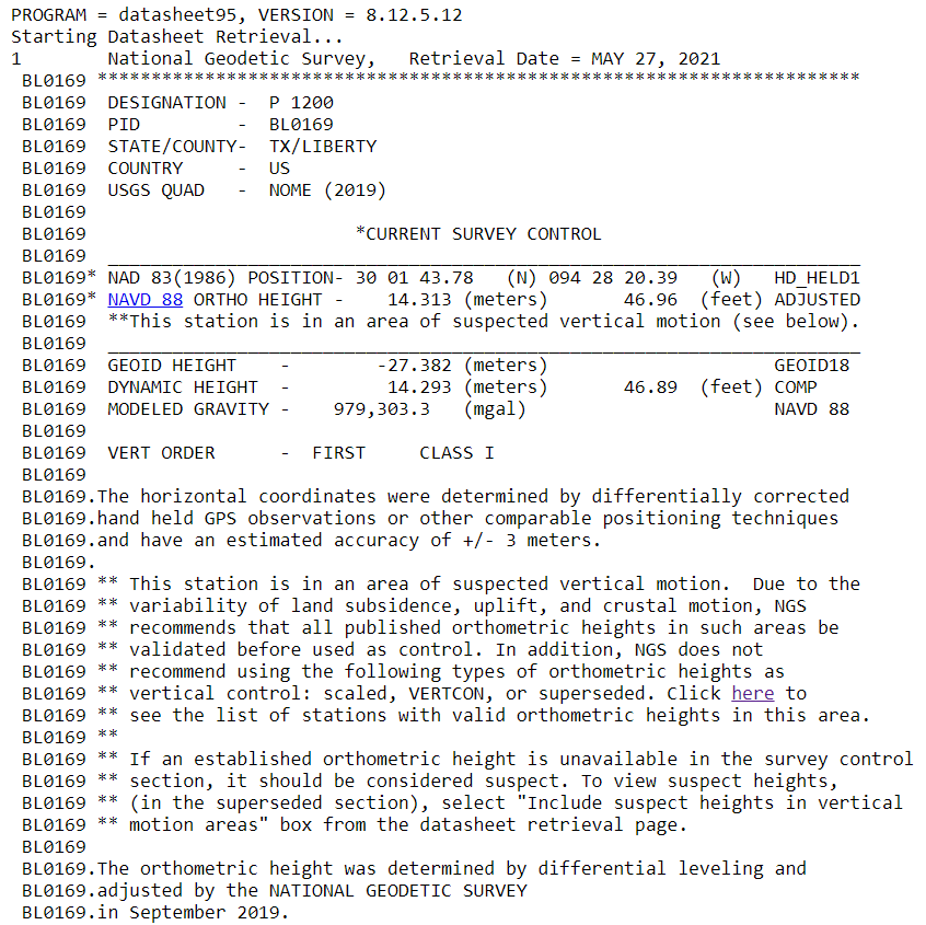
Clicking on an icon provides the PID and name of the station with a link to a datasheet. Click “Get Datasheet” for a datasheet of the station. Below is an excerpt from the datasheet of Station P 1200.
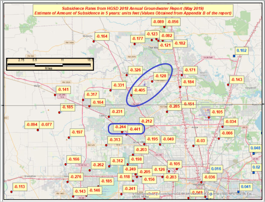
Let’s address why NGS is suppressing the stations in Southeast Texas. My last column provided plots depicting the amount of movement in the Harris-Galveston, Texas, region. See the box titled “Estimate of Amount of Subsidence in 5 Years in Harris-Galveston, Texas, Region – Units Feet.”
As indicated in the plot, some of the marks are estimated to have moved almost ½ foot (approximately 0.15 meters) in 5 years. In addition, some of the relative height differences approach 1/3 of a foot (approximately 0.1 meter) between neighboring stations. See the highlighted stations in the box titled “Estimate of Amount of Subsidence in 5 Years in Harris-Galveston, Texas, Region – Units Feet.”
The last major releveling incorporated into NGS’ Database in the Harris-Galveston, Texas, region was performed more than 30 years ago in the 1986/1987 timeframe. Therefore, some of the published stations in the region could have subsided more than three feet (or about a meter).
As stated in NGS’ Blueprint 3, “Most leveling data in NGS archives comes from the mid-20th century, in support of the NAVD 88 project.” Of course, most regions of the United States are not subsiding at the same rates as in the Houston-Galveston, Texas, region.
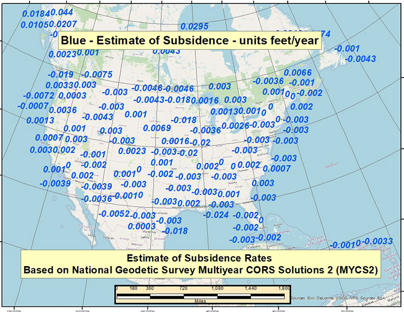
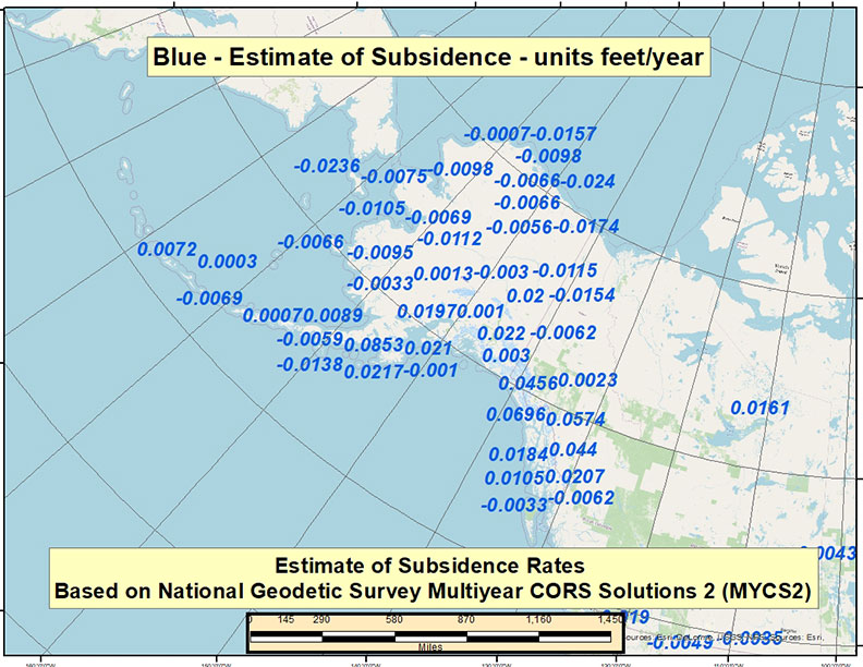
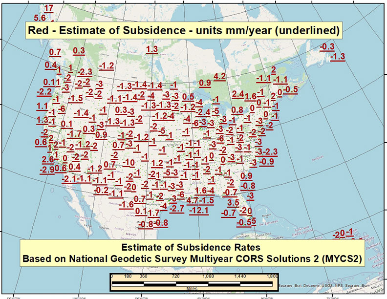
In a previous newsletter, I discussed NGS’ second Multi-Year CORS Solution of the National CORS (MYCS2). I downloaded the coordinates and velocities from NGS’ website and created a plot of the vertical velocities. For those who prefer to use feet as opposed to meters, I provided velocities with units in feet/year and mm/year.
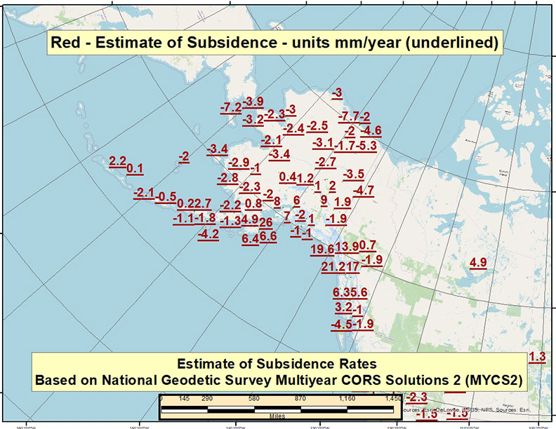
See the boxes titled “Estimate of Velocity Rates Based on MYCS2 – CONUS (feet/year),” “Estimate of Velocity Rates Based on MYCS2 – Alaska (feet/year),” “Estimate of Velocity Rates Based on MYCS2 – CONUS (mm/year)” and “Estimate of Velocity Rates Based on MYCS2 – Alaska (mm/year).”
It should be noted that the intent of these four plots is to provide a wide-ranging view of the values and some of the variation in rates across the United States.
Estimate of Velocity Rates Based on MYCS2 – CONUS (feet/year). (Image: David Zilkoski)Estimate of Velocity Rates Based on MYCS2 – CONUS (feet/year). (Image: David Zilkoski)Estimate of Velocity Rates Based on MYCS2 – CONUS (mm/year). (Image: David Zilkoski)Estimate of Velocity Rates Based on MYCS2 – Alaska (mm/year). (Image: David Zilkoski)
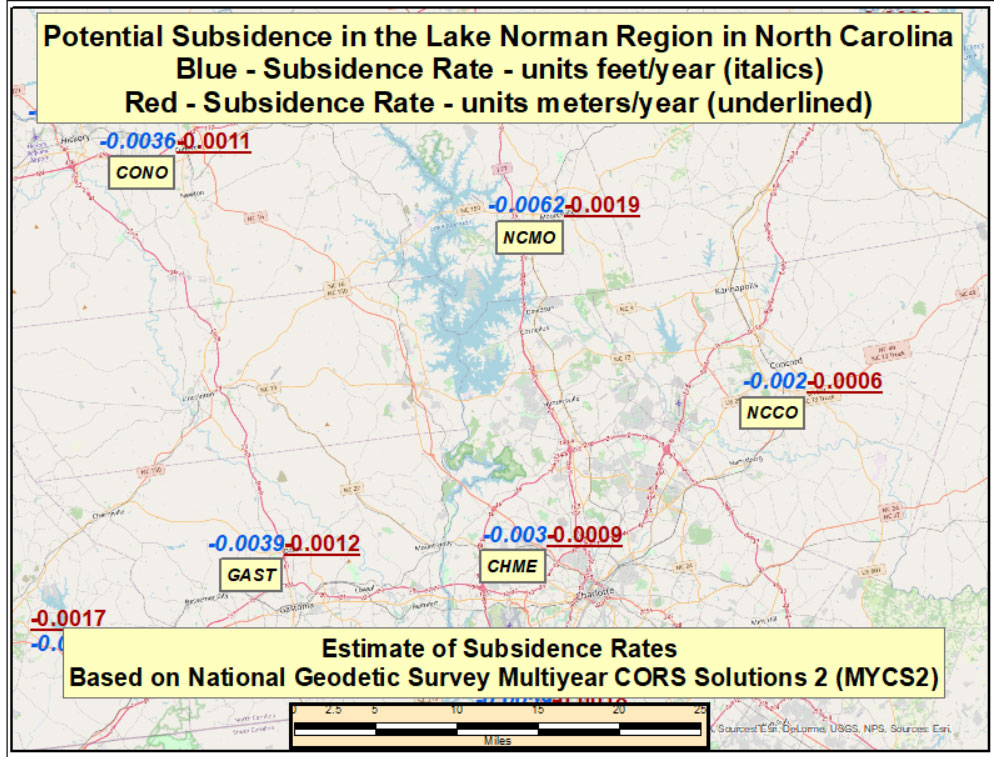
The rates appear to be small in most regions of the United States. As an example, the rates are all less than -0.0062 feet/year (-0.0019 meters/year) in the Lake Norman region in North Carolina (see the box titled “Potential Subsidence Rates in the Lake Norman Region in North Carolina). It would take many years for the crustal movement to make a difference to some projects in this region.
Potential Subsidence Rates in the Lake Norman Region in North Carolina. (Image: David Zilkoski)
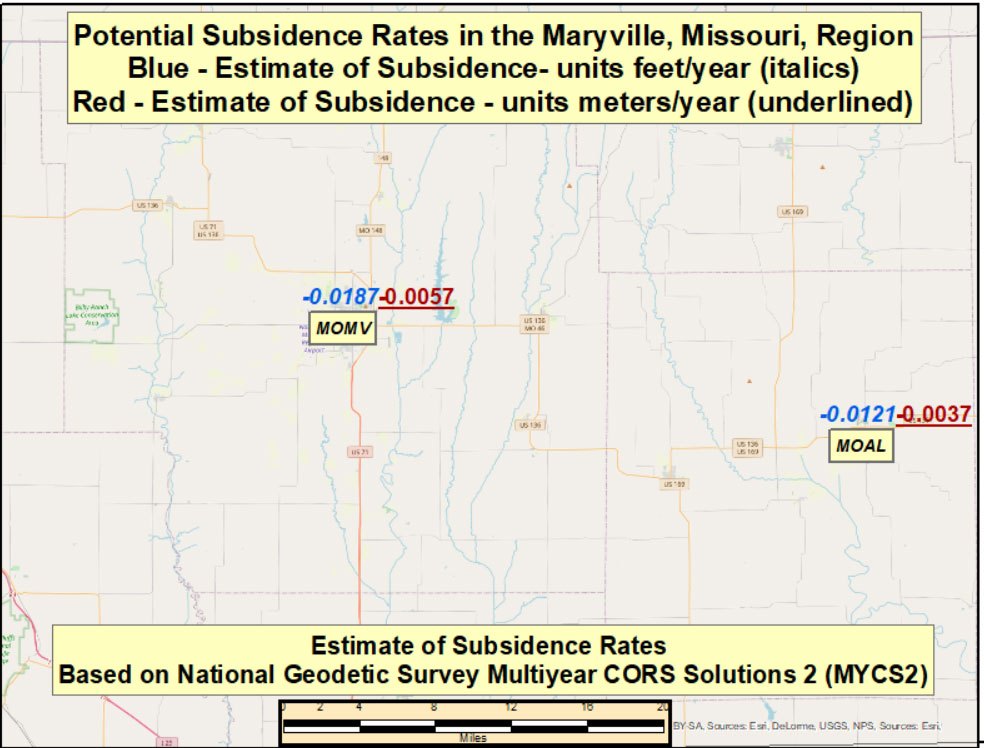
That said, let’s look at another region of the country. For example, in the vicinity of Maryville, Missouri, the rate of subsidence is around -0.0187 feet/year (-0.0057 meters/year). See the box titled “Potential Subsidence Rates in the Maryville, Missouri, Region.” These subsidence rates don’t appear to be large values but if you take into account the last time the height of a mark was established by leveling data it could result in a large difference from the true orthometric height.
Potential Subsidence Rates in the Maryville, Missouri, Region. (Image: David Zilkoski)
According to NGS’ database, it appears that many of the marks in the Maryville, Missouri, region were last leveled in 1935. I used NGS’ Passive Mark Lookup tool and Leveling Project Page tool to identify the marks and associated leveling lines in the area of the CORS stations in the Maryville, Missouri, region.
I described the Passive Mark Lookup webtool in a previous column. As previously mentioned, these subsidence rates all seem very small, but if you take into account the last time the height of mark was established by leveling data, the subsidence value can be very large.
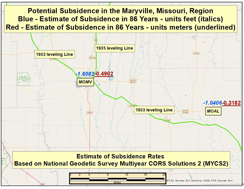
See the box titled “Potential Subsidence in 86 Years in the Maryville, Missouri, Region.” The box indicates that, if you account for the last 86 years (2021 – 1935), the potential subsidence exceeds 1½ feet (-1.6082 feet, -0.4902 meters).
Potential Subsidence in 86 Years in the Maryville, Missouri, Region. (Image: David Zilkoski)
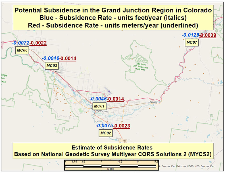
Continuing across the country to Colorado, the box titled “Potential Subsidence Rates in the Grand Junction Region, Colorado,” provides the estimate of subsidence rates in Mesa County, Colorado. As the plot indicates, the rates vary between -0.0046 feet/year (-1.4 mm/year) and -0.0128 feet/year (-3.9 mm/year). Once again, these rates all seem relatively small but many of the marks near CORS MC06 were last leveled in 1985. This means the potential change in height could be as large as 0.2592 feet (0.0792 meters).
Potential Subsidence Rates in the Grand Junction Region, Colorado. (Image: David Zilkoski)
Obviously, this is only an estimate of the subsidence in the region and the actual amount of subsidence is unknown since the last time the mark was leveled. These estimates are based on the MYCS2, which uses current data to estimate the velocity. The processing included data spanning 1996 to 2016 (week 0834 to 1933), 1099 weeks or about 21 years in total.
The point of this column is not to provide the exact change in height of a mark, but to highlight that the publicly available orthometric height on a NGS datasheet may not be up to date based on crustal movement. The new modernized National Spatial Reference System will enable users to determine an accurate, current height on a mark and be able to efficiently and effectively monitor changes in a mark’s height.
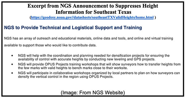
As stated in NGS’ announcement to suppress the heights in Southeast Texas, the agency has developed tools to assist users in submitted data to NGS. See the box titled “Excerpt from NGS Announcement to Suppresses Height Information for Southeast Texas.”
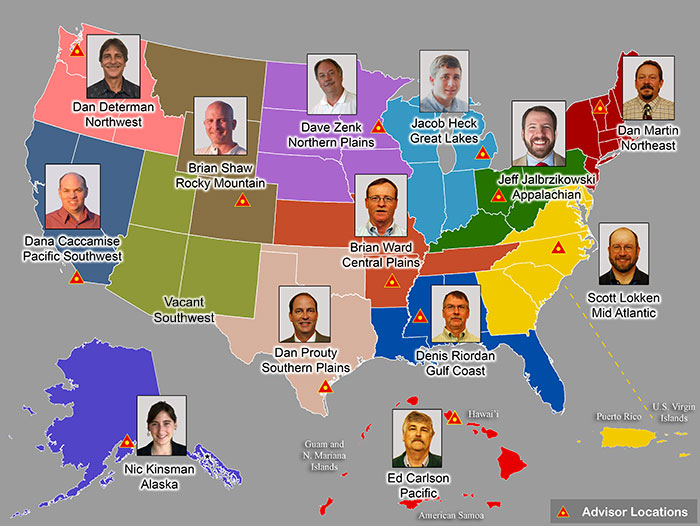
This assistance is for every user, not just for individuals performing surveys in Southeast Texas. NGS has Regional Geodetic Advisors throughout the United States.
The Regional Geodetic Advisors provide guidance and assistance to constituents within their region. They are subject-matter experts in geodesy and regional geodetic issues. These individuals can assist users that are planning GNSS campaigns to re-densify the network.
As mentioned in previous newsletters, a benefit of the new modernized National Spatial Reference System (NSRS) will facilitate the establishment of consistent, accurate NAPGD2022 GNSS-derived orthometric heights.
This column provided details on the suppression of heights in the Southeast Texas region, and potential effects of crustal movement on published heights in other regions of the United States. NGS suppressed the heights in the Southeast Texas region because of the large amount of crustal movement since the last time the heights of the marks were established.
As indicated by NGS’ MYCS2 velocities, every mark could be affected by crustal movement. In my opinion, the question a user should be asking is “How much has the height of the mark changed since it was last determined? Not, “Has the height of the mark changed?”
As the number of GNSS constellations and satellites in orbit continues to grow,
will we reach the point of diminishing returns?
Ellen Hall
“More satellites equal more data, and redundant constellation systems — through GNSS interoperability — can give us more robust PNT, as restated in the January Memorandum on Space Policy Directive 7. That said, there are always diminishing returns. Treaties place liability on the launching country if something goes wrong, but with tens of thousands of small satellites expected to be launched over the next decade, it will be getting increasingly crowded. Concerns are growing about the necessity of increased maneuvers to keep these satellites from a chain reaction of collisions, which ultimately could cause debris to fall to inhabited areas of Earth.” — Ellen Hall / Spirent Federal Systems
Jean-Marie Sleewaegen
“With already more than 130 GNSS satellites in orbit, the benefit of new satellites decreases while the risk of satellites interfering with each other increases. However, this is only considering GNSS as we know it, in the MEO orbit (altitude about 22,000 km). The future of GNSS may well be closer to Earth, in the LEO orbit (<1,000 km), with well-known benefits in terms of convergence time and resilience to jamming. Sooner than later, we can expect constellations of hundreds or thousands of LEO satellites carrying a GNSS-like payload supporting PNT services. No worries, there is still growth potential!” — Jean-Marie Sleewaegen / Septentrio
Stuart Riley
“With the current four GNSS constellations and a typical survey elevation mask of 10˚in North America, we average around 30 visible satellites. Far more are visible in Asia with the addition of the regional systems. In an area with a clear view of the sky, this provides more than enough satellites for precision centimeter positioning. However, most professional GNSS users do not have the luxury of operating exclusively in open areas with ideal conditions. Accessing many satellites across multiple constellations increases the probability of receiving sufficient satellites that produce high-quality measurements in obstructed areas. As the constellations expand, we observe improvement in precision position availability in these locations. The large number of satellites, coupled with independence across the four systems, improves system integrity and continuity while also helping to reduce the converge time in PPP solutions.” — Stuart Riley / Trimble
Bernard Gruber
“In a utopian vision of navigation, data gluttons and like-users of GNSS would say that there will never be enough! If capabilities remained static, then yes, I believe we would reach the point of diminishing returns. I would offer that innovation and competition will continue to drive capability improvements via power, signal quality, coverage, integrity and clock/timing accuracy. These innovations, coupled with user equipment flexibility utilizing signals from space, will drive an ever-maturing market balance and increasing return.” — Bernard Gruber / Northrop Grumman
Last year, GPS World marked its 30th anniversary. That is a testimony to this magazine’s continued relevance, its commitment to its marketing partners, and its unmatched audited audience of 54,000 GNSS/PNT buyers, integrators and specifiers.
Taking on my new role on GPS World’s edit team was a homecoming of sorts because I began my current career a little more than 20 years ago as this magazine’s managing editor. I look forward to an ongoing conversation with many of you in the GNSS/PNT community — scientists, engineers, civil servants, uniformed service members, company executives and product managers. You may get an email message from me, and I will always welcome yours, at the e-mail address below.
“I look forward to an ongoing conversation with many of you in the GNSS/PNT community.”
Let me tell you a little about three passions that led me to this job.
Navigation has been one of my passions since I was a kid. When I was five years old, I lost track of my mother as she entered a store in Berkeley, California, and I kept walking down the street. It happened again when I was seven and had insisted on walking home alone from school in Milan, Italy. I was determined never to get lost again. So, when I was 11 and my family moved to Pisa, I was the only kid I knew who walked around — from school to sabre-fencing practice, to piano lessons, to my bus stop — studying a map and a compass. When I was 13, in shop class, I built a crude optical-range finder, based on trigonometry. Next, came the topo maps I used for hiking the hills and mountains of Tuscany. A few years later, as a graduate student at MIT, I began to sail around the Boston Harbor islands and off the coast of Maine. I learned to navigate using nautical charts, sextants, radio direction-finders, sonar, radar, Loran-C and, finally, GPS receivers.
Magazine journalism has been another one of my passions, since I co-founded a public policy magazine, Oregon’s Future, 25 years ago and became its editor. That was the first of seven editorial positions with magazines I have had over the past quarter century. Finally, my passion for public policy led me to degrees in political science and to my previous career as a research analyst — first for an independent research institute, then for state and local government. It gave me a solid grounding in public policy, statistical analysis and querying large databases.
So, this navigation enthusiast, policy wonk and experienced writer and editor is now in position to report on and advocate for the continuing growth and development of GNSS. I will also showcase new products and projects, and present facts and opinions from across the GNSS/PNT community.
This month’s cover story on autonomous vehicles is a perfect example. It confirms the central role of GNSS in one of the most significant technological advances we can expect to see in the coming decade — having vast implications for our society and environment — with facts and opinions from four industry leaders.
19% of tracked space objects threaten GPS and other GNSS satellites. While there are many fewer objects in MEO than in LEO, the risk in the former is arguably greater because GPS is so critical to almost all of our technology.
The Risk
GNSS satellites, especially GPS satellites, are critical to the well-being and smooth functioning of economies and national security. This is especially true in Europe and the United States, which do not have complementary terrestrial systems able to provide vital positioning, navigation and timing (PNT) services when signals from space are not available.
While the probability of debris damage to GNSS in medium Earth orbit (MEO) is much less than for satellites in low Earth orbit (LEO), the consequences of such an event would be much, much higher. The loss of one satellite would be a concern; that of multiple satellites, a major problem. The unthinkable chaos, national security damage, and severe economic impacts to the $21 trillion U.S. GDP make the risk unacceptable.
For those who think we need not worry about the low probability of collisions at MEO, the Galileo collision avoidance maneuver in March 2021 should be a wakeup call. The problem is here. We need to act now.
Background
Much like a nuclear fission reaction, the problem of space debris starts small then grows exponentially, as each collision creates more pieces that, in turn, can collide with other objects.
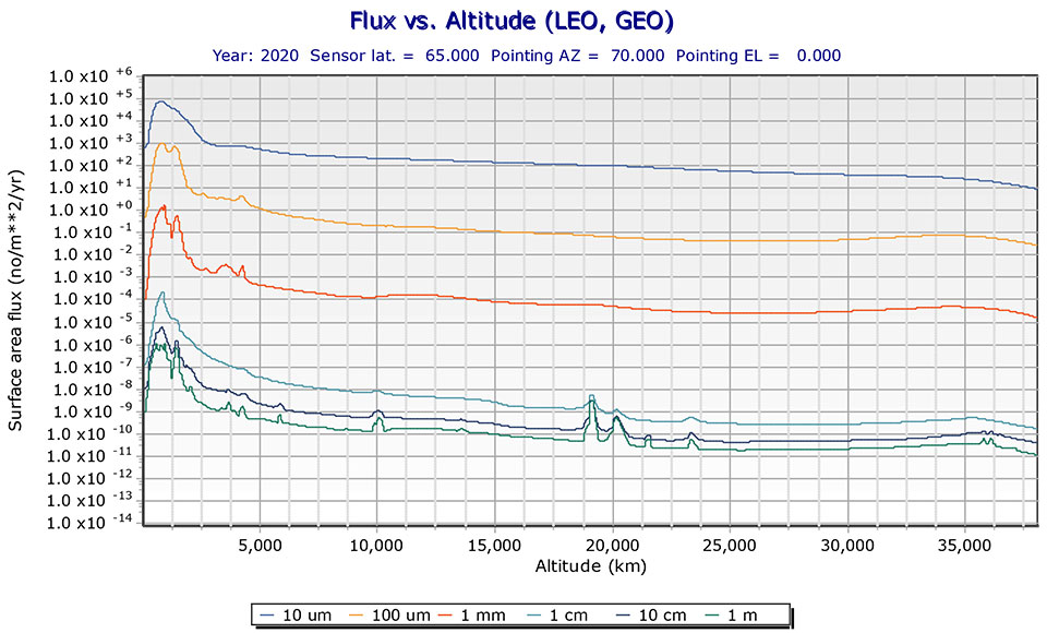
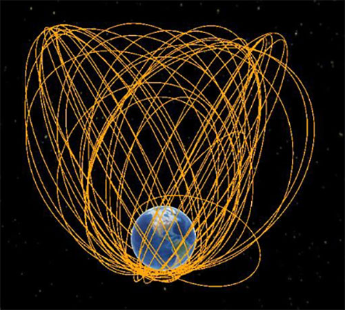
The MEO debris environment is 100 times less dense than the LEO. The spatial density of orbital debris in LEO (up to 2,000 km), shown in Figure 1, suggests that LEO is the likely location where a runaway chain reaction will initiate. This could easily result in a region of space so dangerous that it would effectively deny access to MEO, where the GPS constellation resides.
While the debris situation at MEO is much better, there are still 4,021 tracked debris objects that could impact GPS and other GNSS satellites. Because future orbital debris collisions in LEO will be responsible for more debris in MEO, the situation is guaranteed to get worse. The dead and debris objects in highly elliptical, or Molniya, orbits, shown in Figure 2, could be responsible for such collisions pushing LEO debris into MEO.
Contributions to the general MEO debris population come from launch systems and other factors. Early GPS satellites (Block II/IIA/IIR) used internal orbital-insertion motors to avoid leaving uncontrolled stages in the operational orbit range when moving from transfer orbit to MEO. For survivability reasons, they were also deployed with sufficient fuel to make several major orbital moves. Unfortunately, later versions used separate orbital-insertion stages, which were left drifting in the orbital neighborhood and carried less fuel, resulting in fewer possible maneuvers to avoid collisions.
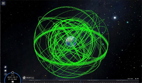
Using the CelesTrak visualization interface to extract space situational awareness data captured by the Combined Force Space Component Command’s 18th Space Control Squadron (18 SPCS) reveals a much more dire image of MEO. Of the 21,266 total tracked objects in Earth’s orbit, 157 are active GNSS satellites, as shown in Figure 3.
Figure 3. Active GNSS satellites. (Image: Celestrak)
However, a total of 4,021 objects reside or pass through MEO, which are either active (331), dead (668), debris (1,761), rocket bodies (1,100) or unknown (161) objects, as shown in this video.
These 4,021 objects represent 19% of the total number of tracked objects from the 18 SPCS space catalog. While the total 21,266 tracked objects is a far cry from the 100 million objects NASA’s Orbital Debris Program Office represents, one can imagine that a significant portion of untracked debris objects, under 10 cm in size, reside or pass through MEO as well. This is significant, according to NASA, which says that objects with a diameter of 1 cm to 10 cm are the most dangerous due to the lack of tracking data, which essentially makes them invisible.
False Sense of Security
The growing orbital-debris concern is a threat too big to ignore. Unfortunately, to date attempts to manage space traffic have amounted to passive measures, such as establishing policy, characterizing the environment, and creating orbital protection guidelines. Even the highly touted, $6 billion U.S. “Space Fence” is a passive measure that contributes nothing active to solve the problem. Not at all a “fence,” it is merely a way to detect the larger and more dangerous debris.
These efforts may, in all actuality, be counterproductive if they instill a false sense of security in the public and government leaders that the problem is being adequately addressed.
A Proactive Solution
Since 1978, the orbital debris population has been touted as our biggest space problem. It is important to do as much as we can with policies and procedures to keep the problem from getting worse faster. However, even if we humans were to completely resist our seemingly natural impulse to pollute everywhere we go, collisions with existing debris would continue to increase the number of dangerous objects in orbit.
Active debris removal (ADR) is the only solution. The sooner it begins, the safer we will all be. Like the oceans and cyberspace, orbital space suffers from the tragedy of the commons. Everyone wants to use it, but no one owns it. No one is responsible for ensuring it is cared for and maintained. As a result, user behavior is difficult to control, and the environment often suffers. Government action, presumably supporting the best interests of all users, is the default answer.
The proposed Space Debris Act of 2021 is a great start. It paves the way for persistent funding and creates an industry responsible for safeguarding humanity’s orbital infrastructure. It would introduce tax credits to incentivize non-government funding contributions and reduce the price of debris removal, so that satellite operators and the emerging space tourism industry can afford to clean up space where they plan to operate.
The bill is currently being presented by OrbitGuardians to members of Congress for sponsorship. Organizations wishing to support these efforts should contact Ken Eppens at OrbitGuardians at [email protected].
GPS/GNSS and other critical space assets are at an unacceptable level of risk from debris. It is time to safeguard orbital infrastructure to protect the interests of the United States and humanity’s future in space.
This month, the four-pound Integrity dual-rotor UAV on Mars continues to fly and may be moving into a scouting role. Plus, there are continuing efforts to move UAV electronics towards a “certifiable” level to support integration in regular airspace. Finally, a newly launched parcel delivery drone has increased carrying capacity.
The excitement around flying an unmanned helicopter on Mars is gradually dissipating as Ingenuity racks up more flights and the NASA team prepares for an elongated flight schedule following the initial 30-day flying experiment. Data from the Martian UAV passes back and forth through the Perseverance rover, which now has things of its own to do and places to go. An initial 30-foot crawl a couple of days ago signaled the beginning of the rover’s ground activities, which are the main focus of the mission.
However, the little UAV has achieved plenty and appears to have lots of life left to fly. We’re now up to five flights, with the latest taking Ingenuity more than 420 feet, flying at a height of 15 feet to a new landing spot, ahead of where the rover intends to travel.
Before landing, NASA took the UAV up to 33 feet, where future flights should be able to better view features for the rover to investigate. Integrity’s role may now transition to scouting an advance path for rover exploration — one of the principle objectives for the little UAV.
A tiny speck in the distance, NASA’s Ingenuity UAV flies on Mars looking for a new landing spot during its fourth flight. (Photo: NASA)
NASA is planning a few additional trips for Integrity in the next week or so — adequate power is being captured by the top-mounted solar cell to fly and keep the vehicle warm through the cold Mars nights, and the miniaturized avionics systems are holding up well. Hopefully, we will still hear of new accomplishments in weeks to come. Incidentally, Perseverance can now capture the sound of the UAV’s spinning blades and the background wind on the surface of Mars.
FAA certification for drones
News here on Earth is about much more capable unmanned vehicles, new innovations and new applications, and efforts seem to be gaining ground toward certifying UAS and their systems to recognized Federal Aviation Administration (FAA) standards, so integration into the National Airspace System (NAS) might roll out sooner than expected.
When a manufacturer produces an electronic component and qualifies it to the necessary FAA standards, it does not automatically make it a certified product. It only becomes certified on a particular model of aircraft or UAV when the vehicle is certified for operational use by the FAA. There are similar standards and certification requirements in Europe and around the rest of the world.
Enter George
Photo: uAvionix
uAvionics in Leesburg, Virginia, recently launched a new certifiable UAS autopilot — with the cute name of “George.” As older aviation enthusiasts might recall, this moniker was what the World War II pilots of long-range piston engine bombers sometimes called their rudimentary autopilots, which held wings level on long-endurance flights.
With triplex gyros and accelerometers, dual processors and compasses, and a barometer, the unit is lightweight and low power, but has been developed to all the principal aviation requirements, including software and environmental standards.
George joins uAvionics’ line of other aviation qualified/certifiable hardware for UAVs. This includes the ping200X ADS-B for beyond-visual-line-of-sight (BVLOS) detect and avoid, and the trueFYX TSO-C145e certified GPS receiver.
Seeking Certification
Sagetech in White Salmon, Washington, is another supplier working hard toward certifiable equipment for unmanned aircraft. Sagetech’s detect-and-avoid (DAA) solution makes use of its ADS-B transponder, which can be paired with other airborne collision avoidance system (ACAS) components.
Sagetech offers a design engineering service to enable UAV operators and manufacturers to come up with a certifiable solution while FAA standards are still being developed.
Embention in Alicante, Spain, also advertises several certifiable autopilots, power and control components for unmanned aircraft. It manufactures a variety of Nmand-branded UAVs along with multi-rotor UAV solutions, including a drone recharging station.
Three times the cargo
Meanwhile, drone-delivery capability continues to advance with the recent introduction of the certifiable Wingcopter 198.
The Wingcopter 198 drop-winch cargo drone. (Photo: Wingcopter)
The vertical-take-off-and-landing (VTOL) delivery drone has a triple-drop winch mechanism that allows for delivery of up to three packages per flight. The UAV takes off and lands vertically, thanks to its tilt-rotor design, and can carry a payload of up to 13 pounds. It can travel up to 47 miles on one electrical charge at up to 93 mph; with fewer packages, a range of up to 68 miles may be possible.
The VTOL UAV has redundant design elements that position it to support FAA certification. It has eight redundant motors. Also, the autopilot, airspeed sensor and battery are dual redundant. Consequently, the Wingcopter 198 is undergoing FAA-type certification in the United States.
The Wingcopter 198 also has artificially aided downward-looking cameras to support management of parcel delivery, as well as obstacle avoidance and landing.
To sum up, life may not yet be over for the Integrity UAV on Mars as it moves into a route-scouting role for the rover. There is more progress toward certifiable configurations of equipment to support unmanned integration into the NAS. Finally, last-mile parcel deliveries could benefit from higher capacity certified drone carriers.