Category: Opinions

  • How public safety GIS saves us when disaster strikes

    How public safety GIS saves us when disaster strikes

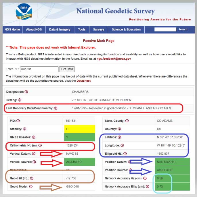
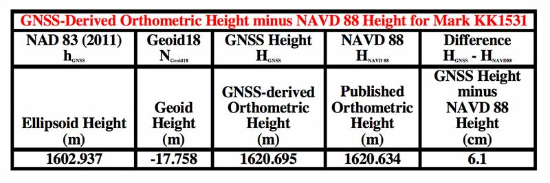
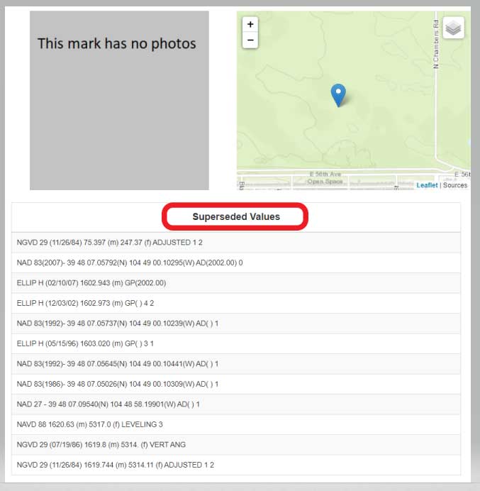
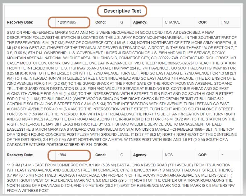
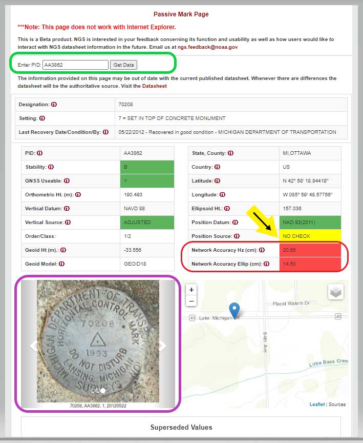
    Tenacity of spirit is one of the great virtues. Supporters of geospatial technology have often had to endure steadfast resolve convincing others of the multi-dimensional value GIS provides. It is a battle best won by seeing and doing rather than by words.

    Jack Maple proved the value of GIS to public safety in the early 1990s by using it to fight crime. But, in the context of firefighting and disaster operations, GIS had not been used.

    Then, in the early 2000s, due in large part to 9/11, the government’s interest in GIS increased.

    It was a necessary evolution. Technologies at the time were rapidly advancing. Computer graphics, computer processing power, the internet, shared databases, GPS, digital imagery, and mobile devices needed to merge. GIS was the only solution to bring them all together.

    At the same time, disasters became increasingly destructive. Public safety and emergency management needed solutions, but most of the funding is by the government with tight budgets, so investments into geospatial technologies and specialized staff were limited.

    It wasn’t until 2010 that FEMA hired the first Geospatial Information Officer. And, the Geospatial Data Act did not become law until 2018. The need was there but not the resources.

    Logo: NAPSG Foundation

    A small group of individuals saw that gap and together they began providing support to the public safety sector. The first organization they were able to work with was the National Association of State Fire Marshalls. Word quickly spread. Soon, other organizations began asking for geospatial services.

    Eventually, 11 national organizations came together to provide support, structure and purpose for the fledgling team of GIS volunteers. This group became the founders of the National Alliance for Public Safety GIS (NAPSG) Foundation.

    Now, 15 years later, NAPSG has contributed to recovery after every major disaster and many minor ones throughout the United States. Its success extends internationally — NAPSG has helped other countries set up their own public safety GIS support teams.

    Image: NAPSG [https://www.napsgfoundation.org/]
    Image: NAPSG

    Membership in NAPSG has grown to more than 65,000. Its members are involved in supporting operations for fires, flooding, search and rescue, earthquakes, storm and tornado damage, health crises, chemical spills, and more. They have become central to emergency management operations, helping coordinate efforts of multiple groups through GIS platforms.

    During and after events, NAPSG hosts debriefs to evaluate and improve ongoing and future operations. The result advances the field of public safety. NAPSG also provides education to its constituent communities and makes its training available to the public.

    NAPSG and its members are highly valued. Every state GIS council has the group as a point of contact. NAPSG is a trusted entity at the community level up through to the highest levels of the federal government, and they are one of the first calls FEMA makes in a crisis.

    Tari Martin
    Tari Martin

    I had the opportunity to interview Tari Martin (GISP), the director of national and federal programs, one of the leaders in NAPSG. Speaking with Tari made me realize that GIS is still early in its adoption phase. Tari is one of the founders of GIS at the state level. Earlier in her career she was the first person in the state of Maryland dedicated to supporting emergency management operations.

    She helped build Maryland’s emergency management framework coordinated efforts with the National Incident Management System (NIMS), and she began pulling in federal data such as the Homeland Infrastructure Foundation-Level Dataset (HIFLD) for use in local operations.

    Now, Tari serves on the Maryland GIS Council for the Public Safety/Next Generation 911 Subcommittee in addition to her regular duties as a director for NAPSG. Tari also serves as a program manager, working to create a universal symbology for public safety and emergency management.

    Maps and map symbology are revered. Map symbology emerged from a long, proud, history of cartography dating back to a time before the Golden Age of Exploration when maps were adorned with beautiful, hand-drawn symbols of wind roses, sea creatures, and exotic plants and animals; including inscriptions, such as that within the cartouche of the Typus Orbis Terrarum (Atlas of the World) by Ortelius in 1573. Therein are inscribed the words from Cicero’s Tusculan Disputations, “Quid ei potest videri magnum in rebus humanis, cui aeternitas omnis, totiusque mundi nota sit magnitudo,” which translated means, “For what human affairs can seem important to a person who keeps all eternity before his eyes and knows the vastness of the universe?”

    Map symbology has been more an art than a science driven predominantly to support specific purposes, such as navigation, war, surveying, mining, construction and recreation. Additionally, symbologies may not translate across professions, regions or cultures. Even when the symbols are the same, the colors may be different giving symbols different meanings.

    Symbols are a visual language, and as the world becomes increasingly smaller and emergency events more international, the need for the language of maps to become universal is necessary. NAPSG has taken on that challenge, coordinating input from multiple stakeholders.

    In essence, NAPSG is working with groups like Urban and Regional Information Systems Association (URISA) to create the Rosetta Stone of map symbology for public safety and emergency management, and Tari Martin is one of the central figures working on that project. The symbol library is free and publicly available on the NAPSG website.

    Tari also reminisced about her early days when she first got into GIS just before Hurricane Katrina, and how many of her co-workers in Maryland mobilized to go down and help out with recovery operations. She stated that was one of the moments in her career that cemented her understanding for the value of GIS in post-disaster operations. Tari now teaches a course on GIS in Emergency Management for URISA.

    NAPSG is involved in cutting-edge technologies helping to shape and educate the public safety community. Its members are working with autonomous vehicles, indoor mapping technologies, augmented reality and virtual reality, wearables, and other opportunities as they arise.

    NAPSG makes its content available online. Explore its best practices, guidance and standards, education and training, events, qualifications and credentialing, toolkits and more. Become a NAPSG member at no cost.

    Prior articles referenced:


    William Tewelow works for the Federal Aviation Administration. He is a graduate of the FAA management fellowship program and while on special assignment to the U.S. Department of Transportation William led a national strategic geospatial project for the White House Open Data Partnership. He is a Geographic Information Systems Professional (GISP) and a Maryland STEMnet Scholar Speaker. He has degrees in Geographic Information Technology and Intelligence Studies, and is currently pursuing a masters degree in Organizational Management. He was among the first in the nation to earn a Geospatial Specialist Certification from the U.S. Department of Labor while working at NASA Stennis Space Center.

    William retired from the U.S. Navy after serving 23 years as a Geospatial and Imagery Intelligence Specialist, a Naval Aviator, a Meteorologist, and a Tactical Oceanographer. He is married, enjoys writing, traveling, solving problems, and is fascinated by new technology and historical context. His favorite quote is, “A man’s mind changed by a new idea can never go back to its original dimension.” ~ Oliver Wendell Holmes

  • The surveyor and the mapper — sharing the same stage

    The surveyor and the mapper — sharing the same stage

    The world of mathematics has always been a mysterious one. It is universally loved by those who enjoy STEM-related fields and occupations, while being generally loathed by those who prefer the arts and humanities (similar to the argument with cats versus dogs, but let us not go down that rabbit hole). It would be easy to believe that if each side sticks to their side of the road, there would be peace and harmony in the world.

    While I cannot speak for the art and humanities group, I can say with certainty that the STEM-related mathematics professions have been known to disagree with each other on various roles within the surveying and mapping world. While surveying has been around since the beginning of time, various forms of organized mapping systems began in earnest in the 1960s.

    When attempts were made to bring the two professions together, each side bristled at being mentioned in the same breath as the other one. The surveyors were the outdoor cowboys with theodolites and tapes, measuring properties and improvements with low precision and accuracy. The mappers, now beginning to be known by the acronym GIS (geographical information system) technicians, were the office computer nerds with punch cards and slide rules.

    Each side did not care much for the other — mostly because they did not understand each other’s role in creating the modern infrastructure database. This relationship would last for decades with no relief in sight.

    Early (and unresolvable) differences

    Each side brought a good argument to the table regarding why the other side was not as important to the authoritative role of map/plat making. For instance, here are the typical stances of each side in the 1970s, before the introduction of personal computers and electronic data collectors.

    • Surveyors worked on the ground and with actual monuments and improvements. They measured angles and distances to collect the pertinent data and drew by hand said information graphically on paper. Because of the accuracy and precision of the field measurements, adjustments were made to the calculations to resolve the unknown errors within the data collection.
    • GIS technicians used a combination of hand calculations, drafting and primitive computers to depict information obtained by existing maps and plats. Because the information being reviewed was not obtained through field methods, parcel lines were forced to fit, improvements to be shown with 90-degree corners, and ambiguities with most data issues to be dismissed.

    Each side stood their ground (in the field or the office) and maintained the distance and differences until more technological revolutions began to infiltrate their vision. At first blush, one could assume these advancements would bring the two factions together; one would be wrong.

    Would you like to play a game?

    Photo: RyanJLane/E+/Getty Images
    Photo: RyanJLane/E+/Getty Images

    The 1980s are known for many things, but for the surveying and mapping communities, it brought a new way of reviewing and storing spatial data. The introduction of the personal computer and vector-based software in the early part of the decade set the pace for rapid and revolutionary upgrades to each profession.

    It was now possible to see on a computer screen what had only been previously possible through manual computation and drafting. As the decade went on, computing speed and storage continued to increase along with the features of software packages.

    However, these advancements did little to bring the surveying and mapping professions together; in fact, the technology has been blamed for causing even more of a divide between the two.

    Again, each side has their reasons for maintaining their hold on being recognized as the authority on the creation of the cadaster layer.

    • Surveyors continued to insist because they worked on the ground and with actual monuments and improvements, the process of putting the data into a computerized format only solidified their position.
    • GIS technicians continued to insist that the refinement of their previous calculations of drafting and mapping into a computerized version further extended their expertise in the mapping world. Also, because many in GIS were specifically trained on computers in college, the work being produced by these members was superior to surveyors.

    Even with the improvements in technology from computers, the divide between the two grew. The relationship between surveying and mapping was at an all-time low, so there must be nowhere to go but up, right? Not so fast.

    GPS + spatial = data custody battle?

    Photo: Magellan
    Photo: Magellan

    Through the 1990s and beyond, the introduction and subsequent rapid implementation of GPS/GNSS gave new meaning to a previous but rarely used term: geospatial data. Only geodesists and higher-end scientists truly worked with geospatial data because of their professional environment and expertise, but now anyone with a GPS receiver became a geospatial data collector.

    Previously, surveyors would measure on a global scale (latitude/longitude and/or state plane coordinates), but this would typically consist of solar and lunar observations under ideal conditions. GIS technicians could only rely on data provided to fit within the location parameters of their projects, which has usually scaled from quadrangle maps.

    However, this new technology was being used with data collectors programmed for almost anyone to use with little to no geodesy experience. Turn it on, press a button and voila — a geospatial location in a variety of coordinate systems. No more sun shots, lengthy traverses from obscure NGS monuments, or scaling from the quad sheets.

    Finally, the surveying and mapping communities have common ground to work on! It would be easy to assume that walls came down and the two professions mended their fences. The short answer is no; they once again did not. Here is each side’s general take on geospatial abilities:

    • Surveyors (once again!) continued to insist that because they worked on the ground and with actual monuments and improvements (though now with improved positioning), the process of putting the data into a georeferenced format only solidified their position.
    • GIS technicians now contended that they, too, could collect the necessary field data using GPS and bypass the need for surveyors. Also, because many in the GIS field were specifically educated to work with spatial data, the information being produced by these members was superior to surveyors’ data.

    We now find ourselves flipping the calendar pages well into the 2020s, with little movement on resolving this relationship. But we can change that if we introduce a little friendlier dialogue.

    In this corner, the surveyor. In the opposite corner, the GIS technician

    When it comes to high accuracy/high-precision data collection for locating existing properties and improvements, there will be little argument that this role is strictly designated to the surveying profession. Technological improvements have made our work more precise and accurate; all while being collected in a georeferenced system. The relationship between the surveyor and geospatial data was previously discussed to demonstrate the importance of our work and determining existing conditions, (see GPS World July 2020 column). The surveyor’s ability to be able to collect an enormous amount of geospatial data for surveying purposes is not being questioned, but the line to where the work encroaches into GIS territory. Spoiler alert: Practically everything the surveyor collects can be considered GIS information as well.

    Let us look at the relationship from the GIS perspective. The input and oversight of the parcel layer must rely on the licensed land surveyor to provide, while the GIS community is charged to collect necessary information to include into their database. It would make sense to update existing infrastructure information using current technology or historical archives in which the position of the data can be verified. Either way, it is now going to be referenced by its geospatial position rather than a relationship to a parcel line.

    Also, the GIS technicians have the same or better capability to utilize data collectors with GNSS receivers for locating existing improvements for inclusion into their system. Most of these technicians have access to the same sources providing the GNSS equipment and coupled with their education and skills, they can collect the data as well as any survey crew. B

    ut does this data collection by a GIS technician fall under most state statutes for surveying without a license? Spoiler alert: The short answer is yes, it does if any data collection includes parcel monumentation and could depict a relationship to a parcel line.

    The whole is greater than the sum of its parts

    Before both parties of this discussion get their pitchforks and torches to have a “talk” with this author, let us take a step back and reassess where we are today with technology and looking toward a future together. The common element here is the data, but how each party uses the data does vary.

    The surveyor typically uses geospatial data for several applications; boundary determination, existing planimetric and topographical conditions, and physical depiction of proposed improvements. The surveyor’s data should be considered as a snapshot in time of the conditions of a particular site or project area.

    Because of emerging technology, it is not just manually collected survey points using conventional equipment; it can be point clouds and 3D photographs not possible 20 years ago. The surveyor can be considered a high-tech record keeper and can update information as sites change. All because the collected geospatial data is timestamped and memorialized in a digital database.

    GIS professionals, on the other hand, require similar information but for many different purposes. Attributes play a much bigger role in the geospatial data requirements than surveyors because the information found within tells them an important story.

    Photo: aydinmutlu/E+/Getty Images
    Photo: aydinmutlu/E+/Getty Images

    The biggest improvement because of the increasing accuracy of the data is infrastructure. As aging utilities require replacement, locating old facilities can be difficult based upon old mapping. Geospatial data collection provides more reliable locations once old facilities are found, existing conditions are reported, and crucial information about its lifespan is collected for future consideration.

    Newly installed utilities will have the luxury of significant attribute data applied to each structure to help with future monitoring and maintenance. These are some of the factor that apply to effective asset management and can be applicable to both public and private clients.

    While the surveyor and the mapper use geospatial data for similar yet different uses, the product is generally the same. But this discussion is not just about merging data into one big global database; we need to dig a little deeper on how to grow each side of our professions together.

    Growth is never by mere chance; it is the result of forces working together

    The surveying and mapping professions have been at a crossroad for some time and both sides continue to ignore each other. Both believe that geospatial data is theirs to control, and they both are right. However, each have a different stake in this geospatial data discussion and need to learn to respect each other’s role. Each side brings a different perspective how to grow and advance our world through effective and efficient surveying and mapping, but they must start talking to realize how much they can grow together.

    With a little more focus and education of each other’s roles on both sides, an overlap of responsibilities could mean faster approach to modernizing many aspects of our respective professions. For instance:

    • Cross training of surveyors in GIS software, data collection requirements, parcel modules, and layer nomenclature
      • Encourage surveyors to apply for GISCI Certified GIS Professional (GISP) testing
    • Cross training of GIS professionals and technicians with survey technician programs
      • Encourage GIS personnel to apply for NSPS Certified Survey Technician (CST) testing
    • Both surveyors and mappers cross training with data collection systems capable of collecting geospatial data containing specific positional information and attributes
      • Identifying limitations of various equipment and techniques (i.e. using the right “tool” for the job)
      • Understanding of positional tolerance (precision versus accuracy) and metadata
      • Comprehension of coordinate systems and zones, including low distortion projections (LDP)
      • Distinguishing between surveying and mapping data collection (i.e. boundary/right-of-way determination versus infrastructure collection for inventory)

    Light at the end of the tunnel

    Technology has introduced our world to many advances not thought possible for our entire existence. The Fourth Industrial Revolution (see GPS World July 2019 column) is now taking aim at industries like surveying and mapping through automation and artificial intelligence capability.

    Data is crucial to everything and our respective professions are in the center of the revolution. 2020 and our worldwide pandemic of COVID-19 has been (unfortunately) perfect example of how data affects our world in real time. The more critical and accurate data that is collected, the better we can make assessments of situations.

    Surveyors and mappers are doing the same thing with data; survey data helps design our world through establishing accurate conditions, while GIS data helps to evaluate our current conditions and plan for future situations. Both professions rely heavily on data, collected in similar methods, but for separate but similar uses. Each has their strengths to bring to the collective table and can increase the effectiveness of digital modeling going forward.

    Photo: PeopleImages/E+/Getty Images
    Photo: PeopleImages/E+/Getty Images

    Let’s make a plan

    The world is moving toward digital twins, augmented and virtual reality along with autonomous travel; it would be in our best interest that the data used to identify the surroundings for those advancements be correct and seamless from all sources. Let us begin by dropping all the delusions of grandeur for our respective professions and formulate a plan to move forward together. The clock is ticking, and time continues to march on.

    Technology continues, and soon Generation Z will be trying to do our work with their laptops and smartphones from the coffee shops without our help. Because they can. See, it is important, isn’t it?

  • How drones are helping with COVID-19, first response applications

    How drones are helping with COVID-19, first response applications

    A solution for these COVID-19 days, getting to injured people really fast, and potentially even faster first response applications are all new drone applications featured in this month’s UAV summary.

    As people welcome back football this fall — although playing in empty stadiums – most people are staying home to watch the game on TV. Even though some sports teams like the MLB Dodgers resorted to cardboard cut-outs of fans, maybe to encourage players, nothing beats having real people stamping and cheering in the stands.

    So its not surprising that when the Atlanta Falcons play the Carolina Panthers this month at Atlanta’s Mercedes-Benz Stadium, they are planning on having a limited number of real live fans at the game to cheer on the teams. Even in these pandemic days of social distancing and masks, it would seem that a reduced number of fans might space out well in the huge 71,000 seat capacity stadium.

    But the drone angle comes with the clean-up afterwards — 71,000 seats, handrails and partitions take a lot of manual wiping down – so the Atlanta Falcons are bringing on disinfecting drones to do the job, potentially with only 5% of the effort it normally takes.

    There are two D1 drones being used in Atlanta supplied by Lucid, each equipped with a 2.5-gallon tank filled with nontoxic disinfecting chemicals. The sanitation solution is distributed by specially designed ‘electrostatic nozzles’ which spray evenly and mist the area as the drone passes over.

    Disinfecting drones have been used before in places which include several locations in China, the city of Dubai, and company EagleHawk in New York offers drone sanitizing for stadiums and other large public facilities. If this approach works we’ll probably see it in many more stadiums in an effort to safely bring back the fans.


    Not sure how this next item fits into the unmanned category for this month’s article — because its certainly manned. But what the heck, its certainly interesting and worth a whirl.

    Jet packs have been around for a while, but the U.K. company Gravity has come up with a configuration that appears to be reliable and works well. They recently pitched their system for search and rescue in the Lake District — a mountainous area in the North West of England which is extremely popular for hiking, walking and climbing. So visitors will sometimes get hurt falling off a ledge or a high path on the side of a mountain, or just tripping while walking and injuring an ankle, leg or knee. The rocky hilltops, mountains and many lakes of the Lake District attract around 15 million visitors each year, so there is plenty of opportunity for injuries.

    With five miniature jet engines and carrying around 35 liters of jet fuel, the Gravity system range/endurance isn’t that great, but boy is it quick if you want to run up the side of a mountain to find an injured hiker. So more rapid response rather than search — provided you already know where the person is located.

    The system is powered by a double jet-engine held at the end of each arm and a single engine with equivalent thrust housed in the actual backpack. Altogether, over a 1000 horse power, which is apparently enough to pick a person up and keep them suspended at around 10 feet off the ground. Guess you would need quite some strength to hold onto the arm units, supporting one-third of your weight on each arm, but apparently you get some level of stability assistance from a flight control system in the backpack.

    A recent demonstration test in the Lake District with the Great North Air Ambulance Service certainly showed off the suit’s capability to go from the foot of a mountain up to near the crest of the hill in no time flat. Then a regular air-rescue helicopter was immediately called in to take the victim to hospital. However, the current system apparently costs somewhere around $400,000, so its doubtful it will show up for anything but special appearances and demos until there has been significant engineering cost reduction.


    The "Recruit" hi-speed drone is aimed at rapid first response users (Photo: Sonin)
    The “Recruit” hi-speed drone is aimed at rapid first response users (Photo: Sonin)

    Sonin Hybrid has taken another angle to building a drone by developing a hybrid gas powered propulsion system which charges the vehicle’s batteries while in flight, uses a lightweight carbon-fiber frame with folding landing-legs, and is able to fly at up to 140 mph when pressed to do so. Nominal cruise flight is at 60mph, and flight endurance is claimed to be up to 3 hours – over 5 times that of similar competitor drones.

    The Recruit’s options include a stabilized 4k camera, a night vision/IR camera, 30x optical/12x digital zoom camera, a 6k lumen spotlight and a loudspeaker/siren.

    With several trials currently underway with first responders, Sonin is eager to establish the requirements for police, fire and military applications. Let’s hope that the trials all involve getting eyes on a location as quickly as possible so hi-speed drone capabilities are needed. Otherwise all the drone racers will probably scoop up these 140mph puppies.


    So to enable people to perhaps return to watching sports in person during the ongoing pandemic we have drones pumping disinfecting spray all over sports stadiums which can potentially save huge amounts of manual cleaning effort, provided they can adequately sanitize the target areas — specialized spray nozzles help. Then we have a jet-pack system which was demonstrated getting to injured people as quickly as possible to administer immediate care, followed up by helicopter air rescue. And finally if you want a hi-speed, lightweight drone with good payload capability, Sonin has launched the 140mph Recruit aimed at first responders who need a very quick first response.

    These are all completely different applications, all with completely different solutions.

  • Behind GPS is the people

    Behind GPS is the people

    Headshot: F. Michael Swiek
    F. Michael Swiek, president, Mike International LLC

    It is often said that “Behind every successful man there is a woman.” Likewise, if we look behind every significant event, policy statement, technological achievement and milestone in GPS history, there are people. They make the textbook chronologies of impressive progress both personal and human.

    My own 30-year association with GPS has tracked closely with that of GPS World. Here are vignettes that sit most warmly in my “family snapshot album” of great moments in GPS.

    In December 1994, the Civil GPS Service Interface Committee (CGSIC) held its first international meeting in Edinburgh, Scotland, hosted by the Northern Lighthouse Board (NLB). The small team of Americans attending the meeting were invited the following day to participate as the “International Team” in the annual NLB quiz competition held in a venerable pub. The competition is hotly contested each year among the NLB divisions, with the winning division commemorated with a brass medallion on a large wooden plaque kept for decades in NLB headquarters. To everyone’s chagrin, the Americans won. The good humor and boisterous camaraderie of that evening laid the foundation for close and candid dialogue between U.S. and European institutions on a wide variety of satellite navigation issues for years to come.

    In 1996, Charlie Trimble was to introduce Vice President Al Gore in a ceremony at the White House to announce a Presidential Policy Statement on GPS. On the scheduled day, Charlie was unable to enter the White House, despite being vouched for by White House officials, because he was carrying no photo ID. White House security asked me if I had anything official with Charlie’s picture. They finally accepted a copy of the Trimble Navigation annual report, because in the words of one security officer, “I’ve heard of fake driver’s licenses, but not fake corporate annual reports.” Charlie was admitted.

    On September 11, 2001, all of us attending CGSIC and ION in Salt Lake City sat stunned in our conference room watching the news reports from New York. Our meeting sessions were canceled, but we came from our hotel rooms because we needed to be together as friends in our shock and confusion, worrying about our families and friends and what the days ahead would be like. Anyone with a cell phone able to get a line out gladly shared it.

    “I’ll only be a minute, just want to check with my family.”

    “Talk as long as you want.”

    In the mid-1990s in the ION exhibit hall, I was walking and talking with Charlie Trimble, Randy Hoffman (founder of Magellan Systems) and Gary Burrell (co-founder of Garmin), who were engaged in good-natured trash talking about each others’ companies, products and personalities. Glen Gibbons, founder of this esteemed publication, came across us, smiled, and said he was surprised to see such a congenial group of competitors. Charlie responded that in the marketplace they were competitors, but at ION they were all colleagues.

    Glen added, “So, all friends!”

    All three blurted, “Don’t go that far!” amid more laughs and grins.

    The Japan GPS Council became one of the earliest and most influential industry groups in helping to guide the evolution and growth of GPS policy and industry, due to the personal passion of Hiroshi Nishiguchi. When meetings were held in Washington, Nishiguchi, other international representatives, industry and government officials would be guests in our home for convivial dinner chats. Nishiguchi became so comfortable, we considered him like family. He would leave a cardigan sweater in our coat closet between visits, and upon entering our house would remove his tie and suit jacket, go to the closet, and put on his sweater — like Mr. Rogers — before relaxing for the evening. He performed this ritual even when accompanying senior Japanese officials.

    So, while technological milestones and policy commitments tell a great deal of the story of GPS, there are also the unique and cherished people, and the privilege it has been to know them as friends.

  • GPS/GNSS industry recollections and predictions from the GPS World Editorial Advisory Board

    GPS/GNSS industry recollections and predictions from the GPS World Editorial Advisory Board

    Members of the GPS World Editorial Advisory Board share their memories and thoughts about the GPS industry over the past 30 years.

    Find out what they had to say.

    Stuart Riley: GPS: Obscurity to ubiquity
    John Fischer: Modern miracle brings timing to the ‘Information Superhighway’
    Terry Moore: Transiting to GPS and beyond
    Ellen Hall: History of the GNSS industry and milestones ahead
    Jules McNeff: GPS and GNSS: confronting dual-use realities
    Miguel Amor: Four decades of leadership
    Julian Thomas: From racecars to boundless opportunities
    Alison Brown: NAVSYS’ role in WAAS
    Ismael Colomina: Discovering a new GPS journal
    Greg Turetzky: Putting GPS in smartphones
    Clem Driscoll: The evolution of GPS
    Mitch Narins: What it means to be a Gold Standard
    F. Michael Swiek: Behind GPS is the people


    Feature image: Smithsonian; Charlie Trimble provides the 4000A GPS Locator to the Smithsonian Museum. Introduced in 1984, the Trimble 4000A was the first commercial GPS positioning product.

  • What it means to be a Gold Standard

    What it means to be a Gold Standard

    Mitch Narins
    Mitch Narins, principal consultant & owner, Strategic Synergies LLC

    Recently there have been conversations within the world’s position, navigation and timing communities regarding the use of the term “Gold Standard.” Many systems aspire to be a Gold Standard, but what does this mean and how should one rightfully claim this meritorious distinction? For me, to be called a Gold Standard, a system must meet a number of hard and soft performance requirements that instill users with trust and confidence. What are these performance metrics., and how should we measure them?

    I propose that for a PNT system to be a Gold Standard, it must embody and embrace three basic operational aspects in its vision, mission and goals, which drive its design, development and operation:

    Requirements. First, a PNT Gold Standard system must have clear, concise, published and independent operational requirements, established through recognized and appropriate standards — that is, the PNT “promises” of accuracy, availability, integrity, continuity and coverage provided by the system are available to all users, and any changes to these “performance requirements” are communicated and implemented in a formal and transparent process.

    Monitoring. Next, a PNT Gold Standard must continuously monitor the system “health” to ensure that it is meeting all of its promised requirements (accuracy, availability, integrity, continuity and coverage). The measurements and monitoring information must be available to all users so they can, with confidence, independently verify performance in support of their missions and needs.

    Transparency. Finally, and most importantly, a PNT Gold Standard must not only maintain transparency during normal operations, but at the most crucial times when the PNT system is not meeting its promised performance. When “things go wrong,” user communications and constant, continuous, and reliable information flows are essential to retaining trust (that is, the measure of the system operator’s integrity). “We don’t know what happened yet, but we will let you know as soon as we do” is acceptable; saying “no comment” is not. As soon as the cause of the problem is known, it must be promptly shared, in detail, along with the schedule for restoration of normal operations. All changes that will be implemented to preclude such an occurrence in the future and all lessons learned must also be communicated openly and honestly to users.

    So, what is a PNT Gold Standard? It is a system that makes operational promises based on known and controlled standards and requirements and openly shares how performance against those promises is being monitored and assured. It is a system defined by mission, values, standards and operating principles that is committed to free and open communications when promised performance is being met and when it is not. It is a system that transparently documents, communicates, investigates and reports health and status to users without delay. It is a combination of known, measured and exceptional performance provided by a system operated with open, honest, inclusive, transparent and complete communications that evoke user trust. For me, that is what it means to be a PNT Gold Standard.

  • China expanding Loran as GNSS backup

    China expanding Loran as GNSS backup

    An August 2020 paper published by the journal Sensors revealed China’s plans to expand coverage of its terrestrial Loran positioning, navigation and timing (PNT) system with three new transmitter sites in the western part of the country. The article indicates that this is a part of providing a backup system for GNSS.

    According to the paper, “…the vulnerability of GNSS to unintentional and intentional interference signals can be found frequently nowadays. For national security and economic effectiveness, a reliable and complementary navigation system is needed desperately. The suitability of the Loran for a backup navigation system has been evaluated and reported.”

    China has operated a Loran system for decades. While the system is capable of operating independently, its signals are also compatible with systems operated by South Korea and Russia. These are coordinated through the Far East Radio Navigation Service (FERNS) to ensure the systems are complementary and reinforce each other where coverage overlaps. The United States and Japan were also members of FERNS until they terminated Loran transmissions in 2010 and 2015, respectively.

    Image: RNT Foundation
    Image: RNT Foundation

    Little public information about China’s Loran system has been available and our queries have gone unanswered. One of the few documents available in the west is a 2014 paper about Loran-C from the Chinese Academy of Sciences in Shaanxi, China which can be accessed through the RNT Foundation website. It shows substantial Loran coverage in the eastern part of the nation, but only a broken circle indicating “projected coverage” in the west.

    Graphic from 2014 Chinese Academy of Sciences paper on Loran showing projected coverage in the western part of the country with a dotted circle. (Image: RNT Foundation)
    Graphic from 2014 Chinese Academy of Sciences paper on Loran showing projected coverage in the western part of the country with a dotted circle. (Image: RNT Foundation)

    The single transmitter in that area projected by the 2014 paper could provide a strong, difficult to disrupt timing signal for fixed receivers with known locations.

    Three new transmitters will be installed according to the August 2020 paper titled “High-Accuracy Positioning Based on Pseudo-Ranges: Integrated Difference and Performance Analysis of the Loran System.” The increased service in the western part of the country will provide “full coverage” positioning, navigation and timing usable by both fixed and mobile receivers.
    The August 2020 paper is the first known documentation in over a decade of specific Chinese intentions regarding its Loran system.

    Still, it is not a surprise to many observers. At 2019’s Stanford PNT Symposium, Xiaochun Lu of China’s National Time Service Center described the nation’s plan for a “comprehensive” PNT system. This system will include a wide variety of PNT sources including low earth orbit satellites, inertial systems, local positioning systems, and Loran.

    Like Ms Lu, the authors of the August 2020 paper are employed at China’s National Time Service Center, which is part of the Chinese Academy of Sciences.

  • NGS releases beta tool for obtaining geodetic information

    NGS releases beta tool for obtaining geodetic information

    NGS has developed a new beta tool for obtaining geodetic information about a passive mark in their database. This column will highlight some features (available as of Oct. 5, 2020) that may be of interest to GNSS users. It provides all of the information about a station in a more user-friendly format. The box titled “Passive Mark Lookup Tool” is an example of the webtool. The tool provides a lot of information so I have separated the output of the tool into several boxes titled “Passive Mark Lookup Tool — A through D.”

    I will highlight several attributes that I believe will be very useful to users, especially users of leveling-derived and GNSS-derived orthometric heights. I’ve highlighted several attributes in the box titled “Passive Mark Lookup Tool — A” that are important to users such as published coordinates, their datum and source, Geoid18 value, GNSS Useable, and the date of last recovery. All of these values are available on a NGS datasheet but, in my opinion, this provides the information in a more user-friendly format.

    Passive Mark Lookup Tool — A

    (https://beta.ngs.noaa.gov/datasheets/passive-marks/index.html)

    Image: National Geodetic Survey
    Image: National Geodetic Survey

    One calculation that the user can easily compute for marks that have been leveled to and occupied by GNSS equipment, is the difference between the published leveling-derived orthometric height and the computed GNSS-derived orthometric height. This may indicate that the mark has moved since the last time it was leveled to or that its height coordinate has been readjusted since the creation of the published geoid model.

    The table below provides the calculation using the data from the box titled “Passive Mark Lookup Tool — A.” The calculation [HGNSS = hGNSS — NGeoid18; Difference = HGNSS — HNAVD 88] has been described in several of my previous columns (this one, for example).

    Data: National Geodetic Survey
    Data: National Geodetic Survey

    In this example, the difference between the GNSS-derived orthometric height and the Published NAVD 88 height is 6.1 cm. NGS is looking for comments on this beta webtool so if users would like this computation added to the tool, they should send a comment to NGS using the link provided on the site (This is a beta product. NGS is interested in your feedback concerning its function and usability as well as how users would like to interact with NGS datasheet information in the future. Email us at [email protected].) So, the user should ask the question, did the station move since the last time it was leveled?

    Another attribute that would be nice to be part of this tool is which station was used to create the hybrid geoid model. As of Oct. 5, 2020, users have to go to the Geoid18 webpage to get the information. The Excel file and shapefiles provide whether the station was used to create the Geoid18 model. In the case of this example, KK1531, CHAMBERS, the mark was not used in the creation of Geoid18 so NGS felt that the station may have moved and/or the GPS on Bench Mark residual was large relative to its neighbors. See NGS’s technical report on Geoid18 for more information on the creation of Geoid18. The GPS on Bench Mark residual analysis was described in several of my previous columns (see “The differences between Geoid18 values and NAD 83, NAVD 88 values” and “NGS 2018 GPS on BMs program in support of NAPGD2022 — Part 6” for examples).

    The webtool provides a map depicting the location of the station, photos (if available), and previously published, superceded values of the mark. See the box titled “Passive Mark Lookup Tool — B.”

    Passive Mark Lookup Tool — B

    Image: National Geodetic Survey
    Image: National Geodetic Survey

    In the example of Chambers, KK1531, no photos were available. It would be helpful if a user would provide photos to NGS when visiting this station. (Note: NGS has a webtool for users to submit recovery information about a mark as well as to provide current photos of the station.) The new Passive Mark webtool also provides information about the survey projects that the mark has been involved in such as leveling and GNSS projects.

    In this example, mark CHAMBERS was leveled to in a 1984 first-order, class 2 leveling project (Leveling Line number L24838/6) and, in 1995, the mark was part of a GNSS project (GNSS Project GPS1010). It also provides all the descriptive text and recovery information (See boxes titled “Passive Mark Lookup Tool – C” and “Passive Mark Lookup Tool – D”).

    Passive Mark Lookup Tool — C

    Data: National Geodetic Survey
    Data: National Geodetic Survey

    Passive Mark Lookup Tool — D

    Image: National Geodetic Survey
    Image: National Geodetic Survey

    I want to highlight a few other attributes of this webtool. The station, PID AA3862, has an interesting attribute that users should take note of; that is, the NAD 83 (2011) position source is NO CHECK. See box titled “Passive Mark Page for PID AA3862.”

    This means that the mark’s NAD 83 (2011) coordinates were determined without redundant observations. This is not a good survey practice but there are times that a project may contain check observations for some purpose or, more likely, the mark did contain other GNSS vector but they were rejected in the final adjustment. Either way, a good survey practice would be for users to verify the coordinates of these marks before using them.

    Passive Mark Page for PID AA3862

    Data: National Geodetic Survey
    Data: National Geodetic Survey

    As previously mentioned, the tool provides the location of the station on a map and photos if they are available. This is a really nice feature for anyone searching for the mark. The map can be enlarged as well reduced by clicking on the box. See boxes titled “Passive Mark Page for PID AA3862” and “Photos of Mark PID AA3862.” The box titled “Photos of Mark PID AA3862” provides all three photos of mark PID AA3862.

    Photos of Mark PID AA3862

    Photo: National Geodetic Survey
    Photo: National Geodetic Survey
    Photo: National Geodetic Survey
    Photo: National Geodetic Survey

    Photo: National Geodetic Survey
    Photo: National Geodetic Survey

    It should be noted, according to the Geoid18 GPS on BMs dataset that users can download, this station, AA3862, was not used in the creation of Geoid18. The table below provides the difference between the GNSS-derived orthometric height and the published NAVD 88 height.

    In this example, the difference between the GNSS-derived orthometric height and the published NAVD 88 height is 9.9 cm. Also, the webtool provides the network accuracy values for the station. In this example, the horizontal network accuracy is 20.65 cm and the vertical network accuracy value is 14.50 cm (see highlighted values in box titled “Passive Mark Page for PID AA3862”). These are very large network accuracy values. This should be a flag to anyone that is using this station as control.

    Data: National Geodetic Survey
    Data: National Geodetic Survey

    As I previously mentioned, as a beta site, users should verify all information from the site. NGS is requesting feedback on this tool so they can improve it and make it an operational webtool. I encourage everyone to access the tool and check out a few of their favorite marks, and then send an email to NGS informing them of what you like, what you would like to change, and what you would like to see added to the tool.

    NGS is releasing this tool as a beta product to get feedback from users. As NGS states in the heading of the tool, they are interested in your feedback concerning its function and usability as well as how users would like to interact with NGS datasheet information in the future. Email NGS at [email protected].

    One last item that may be of interest to GNSS users is that NGS, working with the University Corporation for Atmospheric Research (UCAR), developed another online GNSS lesson (see box titled “New GNSS Lesson by NGS and UCAR”). These lessons are free but users must sign up to access the website and lesson.

    New GNSS Lesson by NGS and UCAR

    Image: National Geodetic Survey
    Image: National Geodetic Survey
  • Discovering a new GPS journal

    Discovering a new GPS journal

    Headshot: Ismael Colomina
    Ismael Colomina, chief scientist, Geonumerics

    Believe it or not, I remember clearly when one of my colleagues, at the beginning of 1990 in my office, made me aware of the upcoming GPS World journal. He went through the list of the already-appointed members of the editorial board and found some key names; Vidal Ashkenazi comes now to my mind. Later on, we received the first issue which, I am sure, must be carefully stored in the library of, at the time my employer, the Institute of Cartography of Catalonia (ICC).

    I also remember the day we were processing GPS kinematic measurements of an aerial survey conducted with Sercel NR52 and TR5SB C/A-code L1 GPS receivers (one was 33 x 38 x 33 cm3 and 18 kg; the other was even bulkier, and both operated on valves). That was for the new GPS aerial triangulation method.

    Shortly after, the application to airborne laser scanning came, and then INS/GPS integration for airborne remote sensing and mobile mapping. Then came the reinforcing high-speed loop of new applications, technology and challenges. The rest is history. An invariant of these 30 years has been that on our tables there were always one or more issues of GPS World. GPS World issues are always around us, part of our offices’ landscapes.

    Last but not least, I cannot tell apart the early days of the journal from its founding editor, Glen Gibbons, who has to be credited for about half the life of the magazine. He brought me onboard GeoConvergencia and, later on, when GeoConvergencia was stopped, to GPS World. I used to share with him ideas and results, and he used to scold me about not publishing them in his journal.

  • GPS technology will continue to transform agriculture

    GPS technology will continue to transform agriculture

    By Al Savage, John Deere

    Headshot: Al Savage
    Al Savage, John Deere

    While GPS technology originally started as a product of the space race, it has transformed in recent decades to be used in a variety of different industries. Its positioning and navigation capabilities make many everyday tasks easier to achieve. One industry that has continuously benefitted from this technology is agriculture.

    The world’s population is expected to reach nearly 10 billion people by 2050, effectively increasing global food demand by 50%, according to the United Nations. To meet these demands, global agricultural productivity will need to increase by 1.75% a year.

    Currently, productivity is only growing at an average rate of 1.63%, according to the Global Harvest Initiative. Precision agriculture and advanced technologies, such as automation, computer vision, artificial intelligence (AI) and machine learning are already on the farm helping farmers meet this demand, and GPS technology plays an especially significant and transformative role in making this happen.

    Game-Changer

    The development of automated driving and self-driving tractors has changed the game for farming by allowing technology to drive the machines with great accuracy, while farmers focus on other value-added tasks.

    Over time, that technology further developed in conjunction with other technology on the farm, such as GPS. Having a reliable way to keep equipment from running over crops is incredibly important to farmers.

    The GPS technology we use at John Deere is accurate within centimeters and complements the computer vision and sensors within the tractors with precise positioning in the field. This allows the farmer to drive faster without running over and damaging the crop. It also means farmers no longer cover the same ground twice.

    Other technology has also been installed on farming machines to provide added value, especially when paired with GPS. When used alongside sensors, GPS offers the potential to enable real-time data collection. Sensors throughout the field let farmers know things such as where each seed was planted or environmental conditions while spraying nutrients on their crops.

    Historical data from the farmer and garnered through the technology are turned into maps that, when combined with real-time information from the sensors, enable farmers to have even more accurate and precise information about what is happening next in the field, to ultimately optimize operations. This is critical as almost every job that gets done on the farm has to be completed in short time windows.

    Spatial intelligence provides a more vivid representation of what is happening in the field at all times so the farmer can make real-time decisions and plan for the future.

    Tasks such as tilling, planting, spraying and harvesting are easier when farmers have a more precise way to track their position. GPS technology, working in conjunction with computer vision cameras and sensors, allows crops to be distributed more evenly across a field and enables seeds to be planted at exactly the correct spacing and position to maximize yield.
    All of these tasks boost productivity and sustainability on the farm by providing farmers with the data to make informed, sustainable decisions.

    Photo: John Deere
    Photo: John Deere

    Machines Talking to Each Other

    Technology on farms has evolved to the point where machines can wirelessly communicate to each other in the field. This concept, known as machine-to-machine (M2M) communication, is also linked closely to GPS technology. Enabling machines to know where in the field another machine is and what work it has done in real time means the machines work as a team to get the job done in the most efficient way possible with no overlap. Coordination among machines helps farmers avoid redundant effort and the overuse of valuable inputs, which allows for more efficient use of resources and unlocks the potential of automation.

    As the agriculture community continues to work to meet the rising demands for food, fuel and fiber, GPS technology will play a key role to help farmers make more food more efficiently, sustainably and with greater consistency in results. This not only benefits the farmer’s business, but it impacts every single person in the world.


    Al Savage is the StarFire Network manager at John Deere.

  • L5-only receiver designed for mobile phones

    L5-only receiver designed for mobile phones

    Greg Turetsky, oneNav Inc.
    Greg Turetsky, oneNav Inc.

    GNSS receivers first reached the commercial domain in the early 1980s. They were bigger than your average carry-on suitcase, weighed more, and consumed so much power that they needed to be plugged into an outlet. But technology advanced quickly, and by the mid-1980s commercial GNSS receivers were appearing in survey and marine markets.

    Generation 1. The first generation of truly mobile receivers, in the late 1990s, used only L1 C/A code and were typically found in rugged handhelds for outdoor enthusiasts. The receivers began appearing in mobile phones in the late 1990s.

    Gen 2. The second generation added GLONASS. These receivers had to have wider bandwidths on the order of 20-30 MHz to support the GLONASS FDMA signals at a slightly offset frequency from GPS L1.

    Gen 3. These receivers added support for Galileo. They started appearing in mainstream cellphones in about 2014. These phones still retained a single frequency front end in the L1 band, but had separate digital processing chains for all three satellite systems.

    Gen 4. This evolution added support for BeiDou and a single sideband L5 receiver where BeiDou, Galileo and GPS all have modernized signals. These receivers first appeared in phones in 2019 because of the added size, power and complexity of supporting a dual-band receiver. The front end is a burden on many phone models, especially with the rise of 5G. Plus, the L1 band has reliability issues with jamming and interference. The receivers only support a single sideband at L5 and are not utilizing the full capability of L5.


    Read the full white paper from oneNav.


    Why Consumer Devices Need L5

    Every GNSS user in every segment benefits from using the new, modernized signals in the L5 band. L5 signals are more accurate, reliable and available in sufficient numbers to support all user segments. Here are the major advantages of L5 over L1.

    • Signal structure (narrow correlation peak) accuracy
    • Wide bandwidth (multipath mitigation) accuracy
    • Pilot codes (longer coherent integration increasing SNR)
    • Multiple constellations and signals with common signal structure
    • Stronger signal transmission
    • Cleaner band with less interference
    • Signal availability

    The benefits of L5 are clear. That’s why many GNSS suppliers have started building L1/L5 solutions, and they are starting to appear in smartphones. It seems to be a natural progression to add an L5 receiver chain on top of an existing L1 solution and be able to reap the benefits. But bringing along the legacy L1 solution could actually have a negative impact on the overall solution.

    The oneNav L5 mobile GNSS system architecture. (Image: oneNav)
    The oneNav L5 mobile GNSS system architecture. (Image: oneNav)

    L5 Wideband Receiver

    We set out to build a fifth-generation GNSS receiver for mobile consumer products. Its single-frequency design only uses the modernized, wideband signals at L5. It has an acquisition engine sophisticated enough to acquire L5 signals directly and a navigation engine that uses artificial intelligence/machine learning (AI/ML) techniques to fully exploit all the signals in 50-MHz wideband at L5.

    Optimized engine. Building an acquisition engine for the L5 signal is a huge mathematical task. Since the codes are 10 times longer and have a 10 times faster chipping rate, it’s a 100 times more difficult search problem. The oneNav engine solves that problem with a customized array processor that has a GPU-like approach, maintaining TTFF.

    Single-frequency architecture. Pure L5 architecture eliminates the need for a second RF chain. The oneNav L5 engine uses common hardware for signals from all GNSS systems.

    Increased sensitivity. The L5 signal has a modernized signal structure that allows for increased sensitivity for both acquisition and tracking. With wideband architecture, all parts of the L5 signal can be combined for maximum performance and significantly more signal strength than L1.

    Improved time to fix. Dual-band receivers first get a fix on L1 and then begin the acquisition process on L5. By performing the L5 acquisition directly, we save time.

    Acquisition reliability. The L1 signal structures do not have the longer primary codes and the secondary codes like modernized signals on L5 that mitigate many of the reliability problems associated with cross correlation, jamming and spoofing.

    Improved tracking and measurement. Using the full bandwidth allows a more sophisticated channel estimation than a simple pseudorange measurement. With multiple signals contained within the L5 wideband signal, we gain advantages from channel diversity.

    AI/ML navigation engine. A cloud-connected navigation engine uses advanced AI/ML techniques to further improve navigation accuracy. Sophisticated ML techniques to predict if the received signal is line of sight and predict the measurement error caused by multipath. The cloud service allows reflected signals to be used correctly in the navigation solution rather than being excluded due to their multipath content. A sophisticated pattern-matching-based positioning algorithm combines the pseudorange measurements and the environment’s 3D building map model to enhance positioning accuracy in deep urban canyons.

    IP Core

    We designed the oneNav receiver as a licensable IP core rather than a discrete silicon solution. The complete solution includes all the firmware and an RF front-end reference design from antenna to A/D converter. This allows customers to determine how to best bring the oneNav advantages to their products.

    The IP core can be integrated into a larger ASIC such as a modem or an SOC. It could also be implemented as a discrete silicon solution. The RF could be combined into any of these solutions or implemented with other RF components in the system. The measurement and position engine firmware can be run on a dedicated CPU or shared in either the same or different CPUs for flexible system integration optimal for various applications. The IP core is both process independent and scalable. An integrated GNSS core means that GNSS performance can be maintained across multiple platforms and silicon generations, providing consistency of measurement and positioning performance needed to maintain system reliability and fusion.

    In my opinion, the Pure L5 wideband receiver can be considered a next generation — or fifth generation — of GNSS for mobile consumer products.


    Greg Turetzky is vice president, Product, for oneNav, and a member of GPS World’s Editorial Advisory Board. Read the full white paper from oneNav.

  • From racecars to boundless opportunities

    From racecars to boundless opportunities

    Headshot: Julian Thomas
    Julian Thomas, founder & managing director, Racelogic

    When I started Racelogic nearly 30 years ago, I could not have foreseen how intrinsically embedded GPS would become in my life. I started out with the goal of supplying electronic control systems to the motorsport world. From traction control systems to paddle shifters for automatic cars, our technology rapidly built a reputation for quality and accuracy. It was this pursuit of accuracy that led me to GPS.

    GPS can be used for a wide variety of applications, but still not many people realize just how accurate it is for measuring the speed of a moving object. It was whilst looking for a solution to measure ground speed to use as a reference for a traction control system for a 4-wheel drive rally car that we came across an Ashtech 20-Hz GPS engine and were amazed to find out just how accurate the speed output was. This was a turning point in Racelogic’s history, which led to the development of one of our best-known products, the Velocity Box (VBOX), which is used to measure speed, distance and acceleration of vehicles for use in the test and development of new cars.

    It is undoubtedly an exciting time for GNSS. New signals and constellations are delivering a huge improvement in performance, which has spurred the release of new, lower cost, game-changing products into the marketplace. With cm-level position now becoming affordable for almost any application, it will be fascinating to follow how this changes the face of the positioning market, and see what innovations and novel applications will appear.

    Delivering solutions to these emerging applications will require agility and flexibility to integrate GPS with sector-specific technology. If this can be combined with solutions that overcome some of the limitations of GPS, then the opportunities are boundless. I for one am excited to see where the next 30 years takes us.