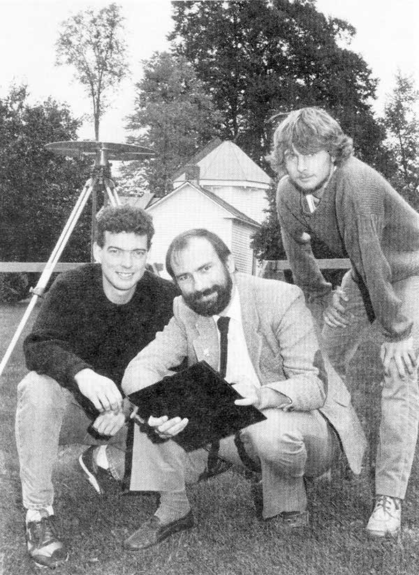
1990: UNB Professor Richard Langley and two graduate students use a GPS antenna (recognize it?) on a tripod to re-measure a historical baseline. (Photo: UNB Perspectives)
When GPS World published its first issue in January 1990, only 15 GPS satellites had been launched, including the 10 prototype or Block I satellites. And four of those early satellites had ceased operation. But there had been enough satellites in orbit for more than a decade to permit early commercial and scientific use of the system. There were even handheld receivers for personal navigation, albeit somewhat larger than those we have today. But it was clear that GPS was going to take off in a big way, and that there was a business case for launching a monthly magazine (bimonthly in its first year) about GPS for professionals in the positioning, navigation and timing communities.
The new magazine was to feature a blend of news, product announcements and articles about GPS, including cutting-edge research on GPS technology and its applications taking place at universities and research institutes around the world. That is why Glen Gibbons, the founding editor of GPS World, reached out to the University of New Brunswick (UNB), an early leader in GPS research and education, to manage a column to be called simply “Innovation.” Glen stipulated that “the column should deal with issues that have broad application and interest and are presented in terms that are accessible to as wide a range of readers as possible.”
Four faculty members were engaged in GPS research at UNB back then: David Wells, Alfred Kleusberg, Petr Vaníček (who famously foretold of the GPS watch back in 1983), and me. Dr. Kleusberg and I volunteered to manage the column and to scour academia and government and industry labs to find authors to write the column’s articles — or to write them ourselves, which we sometimes did. Beginning in 1997, I took over as the sole coordinator of the column — a role I have continued to this day.
There have been close to 300 “Innovation” articles since the first one in the premier issue of the magazine. I’ve also contributed to a number of news and feature articles in the magazine over the years. I might just be the longest-serving active GPS “journalist.” I’m still a full-time teaching and research professor at UNB, and recently took over as the editor-in-chief of The Institute of Navigation’s journal NAVIGATION, but I still have time to write for GPS World and hope to continue to serve the magazine in the years to come.
1976: The first military GPS five-channel receiver built in one of several programs that studied the feasibility of GPS. The receiver weighed more than 270 pounds and had seats for two operators. (Photo: Rockwell Collins/Smithsonian)
Like the internet before it, GPS started as a niche technology and became a universally recognized one, though much misunderstood and often taken for granted. Both systems originated in the U.S. Department of Defense (DOD) to support military missions, and then exploded into mass-market civilian technologies. While the internet passed from military to civilian hands very early in its history, GPS is still operated by the U.S. Air Force, making it a unique experience for the DOD: a system for which it is responsible that has orders of magnitude more civilian applications and users than military ones.
GPS has transformed entire professions — most notably, surveying; created new industries — such as ride sharing; boosted innumerable fields of scientific research — from archaeology to zoology; facilitated many aspects of everyday life — such as finding retail outlets and getting there; and given an advantage to U.S. military forces. One application discussed 30 years ago that has not yet lived up to its promised return on investment is precision agriculture.
Challenges and debates that loomed large in the early days turned out to be growing pains —most notably, Selective Availability (SA). In 1990, Javad Ashjaee reflected the attitude of much of the GPS industry and user community when he said, “I can’t think of a word to say how bad it is.” Other debates have proven more persistent — such as the interference threat posed by LightSquared, reborn after bankruptcy as Ligado Networks.
GPS first drew considerable publicity in the wake of Desert Storm, when it became the subject of television features, newspaper reports, and special sections in the pages of recreational catalogs. “Ironically,” Brad Parkinson pointed out in September 1994 in GPS World, “civil companies [such as Garmin] developed most receivers used in Desert Storm, with no help from military sponsorship.” Later that decade, while most people were finally aware of GPS technology, it began disappearing deep into its applications and the systems that use it.
In September 1991 — three and a half years before U.S. Air Force Space Command declared the system’s full operational capability (FOC) on April 27, 1995 — in a speech to the International Civil Aviation Organization in Montreal former FAA Administrator James B. Busey said: “I want to emphasize that we fully support the eventual replacement of [GPS] by other systems — and we are certain that will happen.” That may still happen, in the distant future. However, what Busey did not foresee is that GPS became but an element, though a key one, in a much larger positioning, navigation and timing (PNT) system. This worldwide system includes three other GNSS and two regional ones, several publicly and privately operated augmentation services, and a wide range of complementary and alternative technologies. These include inertial navigation (which has advanced much in the past three decades) and RF signals of opportunity. It may soon include navigation signals from non-GNSS satellites, eLoran, enhanced distance measuring equipment, and Earth-fixed navigation using very low frequency.
I began my current career in geospatial technologies exactly 20 years ago, as this magazine’s managing editor, just a few months after the end of SA increased GPS’ accuracy by an order of magnitude, and equally expanded the number of its potential applications. Yet today, I still marvel at how pervasive this technology has become and how much further it will transform our lives.
I will end with a quote from an early GPS World columnist, Hale Montgomery, who wrote in October 1991, “GPS users show an insatiable appetite for ever more precise data. Give them a mile and they want an inch.”
Seeking back issues: I have the entire collection of GPS World’s print edition, except for the first issue, the 10 issues in the second year (1991), and the September through December 1993 issues. I would be thrilled to receive those missing issues, or facsimiles, from anybody who has them. Email [email protected].
Our ongoing battle with COVID-19 has shown we can adapt to radical changes. A big, but worthwhile, change would be to convert our existing land databases to a cadastre system.
Any place that one may travel around the globe, they will find boundary lines that define properties and regions. For some countries, these parcels may be primarily owned by the government while in more developed nations, a large percent of the land is owned by private citizens.
These parcels, when looked at together, together create a large jigsaw puzzle that seemingly fits together perfectly. Visually, all the lines should fit snugly to their adjacent neighbor so that the sum of the parts equals the whole. This system, called a cadastre, has many redeeming qualities and makes for an efficient choice of keeping an inventory of a region or country’s parcels and infrastructure.
Origins of the cadastre system
The cadastre system of parcel registration is the database of choice for determining land ownership and taxes on property through much of the developed world. Most of the places where this system of parcel registry consists of centralized governments usually have more oversight and legislative power than more “free” countries like the United States.
Also, these countries in which these systems exist are typically small and/or have a manageable number of parcels so the development of the cadastre is much more controlled and maintained.
To help us understand the origin of this parcel system, let us explore the background of cadastre and its beginnings:
Definition: an official register of the quantity, value, and ownership of real estate used in apportioning taxes Origin: Mid-19th century from French, from cadastre ‘register of property’, from Provençal cadastro, from Italian catastro (earlier catastico), from late Greek katastikhon ‘list, register’, from kata stikhon ‘line by line’. (Source: Merriam-Webster.com)
In the years after the fall of the Roman Empire and through the end of many feudal societies, land ownership was transferred to individuals and families with the expectation of paying a tax to the government for this opportunity. Landowners could plant and harvest their own crops, raise farm animals for labor, and provide various goods and services to the community.
Besides a small fee for conveyance, the government would ask for a “meager” tax to be paid regularly. Land that was sold to these individuals was recorded in a “cadastre” for tracking of ownership and tax payment. These records were primitive in nature and relied heavily on associating a parcel number to the owner versus an actual legal description to describe the property.
It was not until more sophisticated and elaborate surveying instruments were developed that physical descriptions of the land were used to determine boundaries.
Cadastre system gives way to legal descriptions
This cadastre system of parcel management continues to exist in modern times in many parts of the world with one notable exception: The United States. Some will equate our parcel indexing system as being a traditional cadastre, but this numbering procedure is secondary to the means and methods of parcel conveyance in the U.S.
For the non-surveyor reader, in the U.S. over the past few centuries a multitude of land systems have been used to establish parcel boundaries , each with their own unique system of describing land and conveyances. These types of land transactions began after the establishment of the colonial states and rapid expansion into previously unmapped territories.
The push westward across the country introduced the Public Land Survey System (originated by Thomas Jefferson) and established sectional land divisions. As we encountered (and acquired) new territories, including the Louisiana Purchase and Texas, existing land measuring units and description methods were maintained to preserve these systems. No matter how the parcels are described, we rely heavily on the grantor/grantee system of transfer of ownership and rights throughout most of the country, with parcel numbering being applied post-transaction.
So why is the grantor/grantee system the weak link in the chain of parcel establishment and conveyance? Many times, it comes down to the legal description and how it was created. Our system allows for the creation of a parcel by varying means by the professional land surveyor. The biggest issues occur when parcels are defined by a metes and bounds description with little to no reference to adjoining property or known monuments.
When the legal descriptions of these parcels come into play, that is when the trouble starts, with calls made to attorneys and surveyors to help straighten everything out. To the common layperson who owns land or is looking to buy a parcel, it may seem unthinkable that parcels do not naturally fit seamlessly together with no gaps or overlaps. While the quality of survey data has increased in precision, the accuracy of marrying old data with the new suffers in many ways. How did we get to this point? Let us step back in the not-so-distant past to review how things have progressed throughout my short career.
Set the flux capacitor to the early 1980s…
Before computers and CAD, most agencies adopted a system of parcel and right-of-way mapping manually drafted on large sheets of durable paper or film. Depending on the municipality or county one was in, each sheet could represent either a quarter section (approximately 160 acres) or one half of a quarter section (approximately 80 acres) within a standard section of the Public Land Survey System (PLSS) established by the General Land Office (GLO) of the U.S. (now known as the Bureau of Land Management).
These maps were based upon standard measurements within the given quarter section and drawn using 90-degree corners at the edges of the sheet. The linework depicting the parcels within blocks and larger areas was drawn as close to scale as possible but was intended to be a graphic representation of the shape rather than an accurate reproduction. Considering the technology and measuring devices/capabilities of the time, these records were very helpful in performing retracement surveys of existing properties.
Because these surveys and parcel recordkeeping were performed long before computers, plotters, and CAD software became the norm, surveyors calculated and documented their work using manual computation and drafting from handwritten notes collected in the field. Not every parcel has 90-degree corners and lengths that are integers, so mapping departments for governmental agencies drafted new surveys and parcel boundaries to fit within the existing base sheets. Throw in the varying measurements from different surveyors and we have the real-life jigsaw puzzle that does not fit.
Because the aforesaid mapping departments produced parcel numbering after the creation and conveyance of the property, the damage is already done in conforming with adjacent properties. This is an important factor in the professional surveyor’s responsibility to protect the public when performing an original survey for a new parcel and/or subdivision and utmost care must be observed.
We have an army of land surveyors across the country shaping parcels to fit within a large jigsaw puzzle with an instruction sheet that must be strictly followed. One missed measurement or corner monument is in the wrong position, and we now have two or more parcels that will not fit together in the puzzle.
Many mapping professionals will point, however, to the geographical information system (GIS) and how it improved this convoluted method of parcel databases. But did it?
The digital spaghetti bowl
For a large part of the U.S. where a data-intensive GIS has been created and maintained, it is a step in the right direction, but it still lacks the overall efficiency of a cadastre. Very few GIS databases contain survey-grade parcel establishment on recognized horizontal and vertical datums. Most are parcels and roadways digitized from old mapping and records that are vague graphical representations at best.
One of the most important pieces of the GIS database are the base layers that contain control points and parcel/right-of-way lines that coincide with the datums that govern the region or state. Many governmental agencies do not employ a professional surveyor or surveying staff educated and trained to establish these datums within the database.
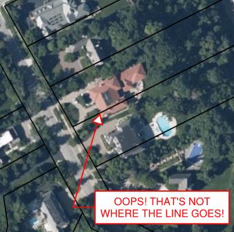
Incorrect GIS parcels information. (Image: Tim Burch)
Most times, the base layers are established “close enough” using aerial mapping and other data, including handheld GNSS receivers to collect infrastructure improvements. This is not a knock on these departments or individuals; they created the best possible database with the information on hand.
When merged with aerial mapping and/or survey-grade data, the graphical information from the archival records can be confusing and misleading, especially to those who are not educated to understand the data.
Is the cadastre an upgrade?
The reason to consider converting all the existing parcel mapping and subsequent infrastructure/improvement mapping to a cadastre are simple: technology. We have previously discussed cities building digital twins (“Surveying and Geospatial Data,” GPS World, July 2020) utilizing remote sensing and a multitude of GNSS-capable products.
Besides surveyors, many professions and trades use GNSS technology as a tool within their work environments. Our nation has experienced rapid growth in the last 150 years. The Industrial Revolution and the advancement of machinery, materials and building techniques have greatly impacted the ability to build more infrastructure and improvements. Many of these improvements and utilities have exceeded their useful life but have no timelines for replacement.
Developing accurate maps of this aging infrastructure will ensure a proper data set from which a replacement design can be made. Couple this ability to work in a geospatial environment with other datasets, including aerial/satellite photography and lidar acquisition, and it gives us a nearly unlimited ability to map our world in appropriate datums with greater accuracy and precision. Governmental agencies could utilize this system to monitor illegal activities (such as dumping, mining, unpermitted construction) and gauge environmental concerns (drainage issues, problematic runoff, deteriorating infrastructure) to better protect the public. This system could also be used to refine our property tax system and work towards a more equitable means of assessing our properties.
None of these potential changes and upgrades would have been possible 40-50 years ago; the invention and adaptation of GNSS have allowed these technologies to emerge. We continue to find new ways of measuring and mapping, so using these new techniques should be foremost on our minds to make these previous tedious tasks much easier to accomplish.
The hurdles to change
The biggest challenge, in my professional surveying opinion, will be adapting millions of parcels and deeds to a new database and applying them to the current datums. For instance, here is an example of potential (and recordable!) legal description:
“Beginning at the northeast corner of the parcel, said corner being the intersection of the south right-of-way line of Smith Street with the east right-of-way line of Jones Street; thence easterly on the said south line of Smith Street to the northwest corner of the Williams parcel per Deed No. 12345; thence southerly on the west line of said Williams parcel to the north right-of-way line of Main Street; thence westerly on the said north line of Main Street to the intersection with the said east right-of-way line of Jones Street; thence north on the said east right-of-way line of Jones Street to the point of beginning.”
Example of “bounds” legal description. (Image: Tim Burch)
While this is only a made-up example, it does represent a generally accepted legal description for parcel conveyance in most recording agencies. What does a mapping department do with this kind of legal description to place it accurately within a GIS or cadastre? Unless the four adjoining legal entities (Smith Street, Jones Street, Main Street, and the Williams parcel) exist geospatially within the database, the technician will have a tough time inserting this parcel into the records. Unless the entire surveying community is up to the challenge of working solely in an approved geospatial datum for all their work, much of this effort will not accomplish anything.
The other roadblock to converting our current systems to a cadastre is the rest of the parties who work with legal documents, plats, and infrastructure; they may not be up to the challenge for making a radical change for the better. From the assessor’s, recorder’s, and mapping offices to the title companies and attorneys, many have an attitude that the system is too big to revamp. Because they only work in one part of the overall system, they do not see the benefit of blowing it all up to make it a more robust and useful database.
Practically speaking…
Revamping of any system within the varying levels of government is costly, no matter what branch or region is discussed. Governmental agencies are being asked every day to do more with less and provide more value in their services with few numbers of staff.
While there may be a large upside to converting our existing databases to a cadastre, the downside is the effort and cost to do so. Yes, the new system would be scalable and easily adaptable for more infrastructure growth and could be expanded in an infinite number of ways. We can liken this proposed idea to converting all weights and measures to the Metric System: going metric will make lots of tasks and procedures easier, but flies in the face of everything we know as a society.
However, our ongoing battle with COVID-19 has shown we can adapt to radical changes. The cadastre is a better system, but I do not want another worldwide disaster to convince us to change.
While connected cars provide wonderful advantages, their integration with cloud connectivity come with a heightened risk for cyber attacks.
Commentary by Alexander Meisel
When it comes to connected cars, automakers are innovating fast. Consumers are experiencing increasing amounts of futuristic features, be they passenger connectivity, automated speed regulation or autonomous driving capabilities.
However, these innovations and their integration with cloud connectivity come with a heightened risk for cyber attacks. A recent study conducted by U.K. self-driving hub organization Zenzic found that becoming cyber-resilient will be the biggest technical obstacle to successfully deploy self-driving cars on roads by 2030. This mountain will be a big one to surmount, and it’s only growing in size: The auto industry has seen a 94% year-over-year increase in hacks since 2016.
How can automakers prioritize security while keeping up with the demand for innovation in today’s connected cars?
Carmakers must consider security from day one
To make sure that security is built into the very foundations of a car, automakers must make it a priority from the first day of design. This focus is lacking amongst carmakers at the moment. In fact, 19% respondents to one survey said they don’t do enough security testing in the design phase, and only 28% said that they do a lot of the testing during the design stage.
Automakers can use design principles to build in security from the outset. For example, the principle of complete mediation allows for enhanced security as it ensures that a software stem “requires access checks to an object each time a subject requests access.” This means that attackers are only invited to exploit a system on one single occasion due to checks on subjects’ permissions.
Carmakers can also ensure that they are not sacrificing security by considering its importance when purchasing components from separate suppliers. These components must be specific enough to enable security in the system, but generic enough to allow for innovation.
Automakers must make cybersecurity a priority from the first day of design.
Here, companies can leverage the software engineering principle of interface segregation. This means that a shrunken, clear interface should be supplied by the vendor, so that the customer only uses the methods that are of interest to them.
In turn, this allows systems to remain decoupled and thus easier to then build a rich interface on top of. However, carmakers will have to stay on top of the security of the part in the development phase, and ensure that dormant functions are not abused by at least logging their execution once somebody tries to call them out of context.
Developers and cybersecurity experts must become a core part of the team
Software development is relatively new territory for carmakers. Now, cybersecurity is a key component of building connected cars, and automakers need to embrace developers that have expertise in this area and make them part of the core team.
This cultural change must be championed by the business leaders to allow car security to advance alongside the innovative features that the industry is building. This can be done by implementing DevSecOps ideology into the team, in order to “build the mindset that everyone is responsible for security.”
Car development teams will likely need a group of cybersecurity experts who can educate the rest of the developers and are willing to participate in the development process in order to check and implement safe and secure functions. If a company doesn’t have this kind of expertise in-house, they can partner with an expert third-party to help them along this journey.
Innovation and security can complement each other
Cybersecurity doesn’t mean sacrificing feature innovation: developments are being made in the field of security too, such as biometric technologies that can be integrated into car design.
For example, Blackberry’s QNX technology “has built in concepts for hardware and software trust validation, hypervisor to maintain a separation between the safety critical and infotainment systems, and a core operating system which passes all the functional safety standards,” according to the company’s senior VP SVP, head of QNX, John Wall. Innovation need not suffer at the hands of security, and vice-versa.
Potential AV thieves would first look to use GPS data to disable or falsify a car’s GPS system, making it untraceable.
In addition, the world’s leading electric vehicle provider, Tesla, ensures security in its cutting-edge, connected cars by sending security updates to cars’ operating systems overnight, and even providing awards for hackers that manage to hack its cars.
Looking ahead to the possibilities of autonomous vehicles (AV) that can drive passengers without needing to have their owner inside, innovation in GPS will be necessary to ensure security and accountability of the car. Potential AV thieves would first look to use GPS data to disable or falsify a car’s GPS system, making it untraceable.
However, carmakers can make this impossible for hackers by not just logging the data in its raw form, but also combining it with other car data using cryptographic algorithms. This ensures that the GPS data remains traceable even after the hardware has been taken apart and sold on the auto-parts black market. In this way, the signature of the original data combined with the GPS position adds an additional layer of security.
Integrating security into connected car design is no simple feat, but it’s a necessary one for carmakers that want to ensure the safety of their passengers while on the roads. By using design principles, diversifying expertise within development teams, and understanding that security and innovation need not be a trade-off, they can do just that.
Alexander Meisel is an automotive cybersecurity engineer at intive. He has a computer networking diploma from Hochschule Furtwangen University, and he has served as a CTO and Development Team Director in previous companies. He has experience with venture capital, successful M&As, and product and technical marketing strategies. He is also a public speaker at technical conferences and trade shows.
A recently unclassified CIA drone program provides us with perspective on UAS development. Also, U.S. high-altitude surveillance capabilities are being tested, another record has been achieved, and an award for the U.S. Air Force space plane.
1960s CIA Bird-Drone
Back when the U.S. was flying U2 spy planes over the Soviet Union and Gary Powers was on Russian TV after being shot down, the CIA got to thinking of another approach for gathering airborne intelligence.
Project Aquiline was an early drone project aimed at making overflight much less conspicuous — because the drone was built to resemble a bird.
Project Aquiline was contracted to McDonnell Douglas, which produced five prototypes. (Photo: CIA Archives)The Project Aquiline bird drone in flight. (Photo: CIA Archives)
With a two-stroke engine driving a pusher-propeller and an 8-foot wingspan, five prototypes were built and tested through 1967-68. The concept was to fly at lower altitudes than the U2, carrying equivalent camera and electronic surveillance equipment, but to be very difficult to observe from the ground.
Although a two-stroke engine might have been somewhat noisier than a large bird, later phases of the program envisaged a miniature nuclear power source which presumably would have been much quieter with a relatively huge range.
The project began in 1966, and prototypes began operational testing in 1968. The prototypes established a range of around 130 miles, took high-resolution images and successfully returned to the control site.
However, with many stages of development still to go (the cost to complete was maybe too high), the project was canned in November 1971.
Maybe this initial “bird” concept is where the name of today’s high-altitude, long-endurance Global Hawk drone originated — who knows?
NASA High-Altitude Long-Endurance (HALE) UAVs
But the U.S. government seems to have other objectives than just high-altitude reconnaissance. NASA has operated the Global Hawk drone for science missions for a number of years, alongside the U-2 and ER-2 high-altitude manned aircraft.
Armstrong Flight Research Center operates two Global Hawks with support from Northrop Grumman out of Edwards Air Force Base.
Global Hawk is flown with a pre-loaded mission profile at upwards of 60,000 feet, sometimes for as long as 24 hours and more than 8,000 miles. Nevertheless, the aircraft is monitored over both satellite and terrestrial links, with direct sensor payload access throughout.
The Global Hawk. (Photo: NASA)
Global Hawk is powered by a Rolls-Royce AE3007H turbofan engine. It has a wingspan exceeding 116 feet, measures 44 feet from nose to tail, has a gross takeoff weight of 25,250 pounds and carries a 1,500-pound payload.
But this aircraft is massive compared to another recent high-flying project that NASA funded through a Phase I and II Small Business Innovation Research/Technology Transfer (SBIR/SBTT) program.
The Swift HALE unmanned aircraft system (Photo: Swift Engineering/NASA)
With the help of NASA’s Ames Research Center, Swift Engineering in San Clemente, California, completed a two-hour flight test on July 7 of its High-Altitude Long-Endurance (HALE) UAS, aiming to join the group of companies already in the high-altitude UAV club.
The 72-foot wingspan, solar-powered HALE weighs <180 pounds, carries a 10-15-pound payload and is destined to fly at up to 70,000 feet for more than 30 days.
This HALE aircraft is expected to complement existing NASA observation platforms and provide unique material alongside existing satellite data. Swift Engineering has been working with NASA Ames since 2016 on a proof-of-concept solar-powered UAS aimed at sustained flight for a month or more.
Swift researched solar panels and high-power, multiple-cycle rechargeable battery technologies to develop a system that could survive harsh temperatures as well as the radiation encountered at high altitude.
During the first of a series of flight tests at Spaceport America in New Mexico on July 7, operations at low altitude were completed to verify systems, aerodynamic control and power-system models. The July 7 flight was the first in a series to collect data and further validate the design.
With NASA, Swift has developed a UAS to not only meet observation objectives, but also one that aligns with the Federal Aviation Administration’s view of HALE deployment and maintenance during extended flights. For the test flight, the vehicle carried a NASA FluidCam for science missions, with a focus on mapping coastal reef systems.
NASA teams are exploring how aircraft such as Swift’s could perform as pseudo-satellites for air-quality monitoring, image coastal zones, map landslides and geologically active regions, and for real-time forestry and agricultural monitoring.
The next step in the development is expected to be a Phase III series of scientific observations at high altitude for days and even weeks.
Boeing X-37B Team Wins Collier Trophy
The Air Force/Boeing X-37B autonomous space plane has won the Collier Trophy for best in U.S. aeronautics/astronautics performance and safety in 2019.
The X-37B set a new 780-day on-orbit record and descended through the controlled U..S National Airspace System (NAS) to land at NASA’s Kennedy Space Center.
Initially launched in 2010, the reliable, reusable and unmanned X-37B has provided space access and subsequent analysis for a large number of key experiments.
The Air Force/Boeing X-37B autonomous space plane has won the Collier Trophy. (Photo: USAF/Boeing)
The space plane has now broken its previous on-orbit record of 718 days and has orbited for 2,865 days and more than 1 billion miles in total. Originally designed for only 270 days in space, the X-37B has established endurance records in every one of its last five flights.
Since 1911, recipients of the Collier Trophy have included Orville Wright, the Apollo 11 lunar landing team, the International Space Station team, the U.S. Navy F/A-18E/F Super Hornet team and the Boeing 787, 777 and 747 passenger aircraft teams.
Intelligence Gathering
News about the 1960 CIA drone developments, aimed at gathering unobserved photo reconnaissance intelligence, provide new perspective on NASA’s current-day use of high-altitude observation assets. These are the same types of assets that the U.S. currently uses for intelligence gathering, despite being recently intercepted by Russian jets off the coast of Alaska. It makes for interesting aspects of drone history, along with new aspects of (very) high-altitude unmanned capabilities.
“We cannot have GPS signals be a single point of failure for transportation and other critical infrastructure sectors. More safety applications will depend on PNT in the future. Public confidence in these will be critical.
“People will not be comfortable getting into an automated vehicle or with platooning driverless trucks heading down the highway if they think that their invisible hand is not reliable and that their GPS might be spoofed.
“Getting public adoption of other PNT capabilities — space-based, terrestrial, and self-contained — integrated with GPS technology will be critical to the success of any such system.”
— Diana Furchtgott-Roth, Deputy Assistant Secretary for Research and Technology, U.S. Department of Transportation, Nov. 20, 2019, Edinburgh, U.K.
A Single Point of Failure
The Department of Transportation (DOT) is responsible for leading civil positioning, navigation, and timing (PNT) issues for the United States. At the moment, the U.S. GPS provides the vast majority of PNT services in the U.S. and around the world. Yet, like all space-based systems, its signals are weak and very vulnerable to interference.
A recent example of how dangerous that can be in automated transportation systems was revealed recently in an accident report released by the British government. Interference from an unknown source caused a 15.5 kg drone to get away from its operator and crash. Fortunately, no one was hurt. The report cited analysis showing that such a weight could have easily killed someone on the ground.
Even more concerning, GPS signal characteristics are well known and therefore easy to imitate. Thousands of cases of “spoofing” have been documented with government and malicious actors causing receivers to report they are far from their actual location. In the worst cases, this can cause accidents or enable criminal acts.
One result of all of this is the President of the United States issuing an Executive Order encouraging “responsible use” of PNT systems. It also directs steps to encourage development and adoption of alternative systems. This includes a White House-level plan for research and development of non-Global Navigation Satellite System (GNSS) PNT.
In Europe the European Union (EU) has warned that space based PNT alone is insufficient for “…critical applications requiring continuous availability and fail-safe operations.” The EU has also established a monitoring system to detect sources of GNSS interference, and the European Space Agency (ESA) has established an on-going program funding study of both space and terrestrial alternate PNT systems.
Multiple Cooperating Systems
The ultimate solution, though, according to senior government officials, will be development and use of many diverse PNT systems working together to ensure users have what they need when and where they need it.
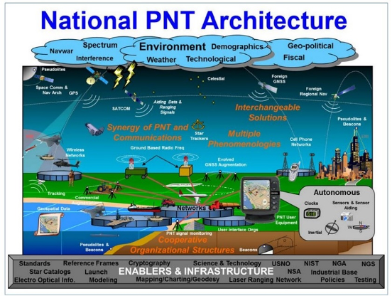
Image: DOT
The National PNT Architecture, jointly developed by the US departments of Defense and Transportation, envisions a multitude of PNT sources ranging from GNSS provided by national governments, to inertial and clock suites acquired by users as needed.
“Many people are fond of talking about a GPS backup,” said one administration official.
“It’s more appropriate to use the plural ‘backups’ since one system isn’t going to meet everyone’s needs. Even GPS doesn’t meet everyone’s needs which is why we require complementary PNT capabilities.”
The idea that multiple redundancies are required for an essential function as long been a core principle of systems engineering. This is clearly foundational in the National PNT Architecture.
It is also a feature in more recent documents.
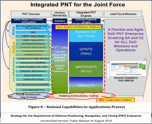
One example is the U.S. Department of Defense’s (DoD) PNT strategy publicly released in August of last year. It envisions use of a multitude of systems as a way of “Ensuring a U.S. Military PNT Advantage.”
Image: DOD
It categorizes these in three layers. A global layer of GNSS and other satellites, a regional layer that includes STOIC and eLoran, and a local/autonomous layer populated by inertial, clock, lidar, radar, scene matching and beacon-based systems.
Another project taking the architecture approach is described in detail by the recently completed MarRINav report. Sponsored by the European Space Agency, it analyzed the PNT needs of maritime commerce in the United Kingdom.
The project concluded that a “hybrid approach” using GNSS, eLoran, and the short-range R-mode VDES would be the best and least expensive combination for maritime. It also recommended a local navigation system such as Locata for port cargo operations. The study found that such a combination of systems would also benefit other transportation and infrastructure sectors.
Implementation
Yet identifying solutions is often much easier than making them happen. Especially for national projects with dozens of stakeholders. Stakeholders who may often have competing interests. And there is always the question of “Who pays?”
In the United States both the Congress and the executive branch of the U.S. government are addressing these issues, and in potentially complementary ways.
Congressional Mandates. With GPS as the cornerstone, both the DoD strategy and the National PNT Architecture show the need for one or more complementary systems to “overcome PNT capability gaps, predominantly resulting from the limitations of GPS.”
According to one senior official close to the issue, these systems need to be, “integrated with GPS and each other” and within the U.S. “serve all parts of the country — urban, rural, wilderness — even coastal maritime areas.” The idea being that they will constantly reinforcing GPS services while also serving as a safety net for users when during GPS disruptions.
The National Timing Resilience and Security Act of 2018 requires DoT to begin filling this layer in the National Architecture by the end of this year. The law, passage of which was overwhelmingly supported by both parties, mandates the department establish a difficult to disrupt, wide area, terrestrial timing system to backup (and complement) GPS timing signals. The system also must be expandable to provide navigation services. Even as a timing service, though, it has the potential to make navigation more reliable. Studies have shown that combining such a timing signal with GPS and other GNSS signals can dramatically decrease users’ vulnerability to jamming and spoofing.
The law also enables the system or systems to be established by leveraging commercial entities and expertise through cooperative agreements, public-private partnerships, and similar arrangements. These tend to be the most expeditious and least costly methods for putting such services in place. As such, they are expected to be very attractive to government program and contracting officials.
On military side, the in-process National Defense Authorization Act for 2021 requires DoD to quickly complete this part of their architecture also. Hinting that the department has failed to respond to combatant commanders “Joint Urgent Operational Needs,” it directs DoD to provide warfighters non-GPS PNT by 2023. It also directs the department to “enable civilian and commercial adoption of [these] technologies and capabilities”.
Presidential Order. The administration’s approach is outlined in a February 2020 presidential Executive Order. The order focuses on commercial entities that contract with the government, critical infrastructure, and research and development.
It calls for, within the next 24 months, agencies to “develop contractual language for inclusion … n the requirements for Federal contracts … with the goal of encouraging the private sector to use additional PNT services and develop new robust and secure PNT services.” The hope is that these new services will be adopted beyond just those companies who routinely serve government needs.
The departments of Energy, Transportation, and Homeland Security are also required to publish plans on how they will engage various critical infrastructure sectors to evaluate the degree of responsible use of PNT by each.
Also, the White House Office of Science and Technology Policy (OSTP) is tasked to “coordinate the development of a national plan… for the R&D and pilot testing of additional, robust, and secure PNT services that are not dependent on global navigation satellite systems (GNSS).” OSTP has already begun this and is seeking input from the public.
Competition and Many Players
Because PNT user needs are so varied and nuanced, most industry observers see growing opportunities for existing and potentially new providers.
“Systems and equipment that improve GNSS services, or that complement and augment GNSS are likely to find ready markets,” said Andrew Bach, a consultant on financial and other PNT issues. “User demands and needs are only going to become more sophisticated as their economic exposure increases.”
Congressional and administration focus on alternative PNT should enhance and multiply such opportunities. So, while there may be no silver bullet for solving national PNT concerns, the need for a robust and resilient architecture of PNT systems will likely mean abundant opportunities for providers.
Recent completion of China’s BeiDou satellite navigation system has rekindled privacy and security concerns among some in the West. China has incorporated a two-way messaging capability into BeiDou that many fear will be used to track individuals and install malware on user devices.
Most satellite navigation experts view such concerns as far overblown.
At the same time, though little discussed, BeiDou’s completion does signal a new phase for China’s status as a world power and its ability to challenge the West on many fronts.
Two-way communications
It is possible for specially equipped receivers to communicate back to the BeiDou constellation. But this is not true for the vast majority of receivers (including those in cell phones). Industry experts say that all mass market chips for every GNSS system, including BeiDou, are “receive only.” Only specially equipped devices will be able to take advantage of its two-way communications capability, and it should be quite apparent to users when it is in operation.
Users, they say, should be much more concerned about location privacy and security issues that have been around for decades. Mobile phones have long reported user locations through the cellular network based upon information derived from GPS, WiFi ranging and other position calculations. The ability to hack and compromise a cell phone or other receiver will not be affected by the addition of BeiDou as a receive-only location source.
It is also important to note that using specialized equipment for two-way communication with a Global Satellite Navigation System (GNSS) is not something new to BeiDou. While the Chinese system may have improved upon the capability, users with the right equipment can send messages using the Search and Rescue functions to the United States’ GPS, Europe’s Galileo, and Russia’s GLONASS.
China has risen
Completion of BeiDou, unquestionably a significant technical achievement, does signal a significant step up for Chin’s status as a world power and influencer. It is a declaration of technical independence from the West with wide ranging geo-political impacts.
“(1) address national security requirements by ending military reliance on GPS;
(2) build a commercial downstream satellite navigation industry to take advantage of the quickly expanding market; and
(3) achieve domestic and international prestige by fielding one of only four such global navigation satellite systems (GNSS) yet developed”
Military Power and National Security. The Chinese military has long sought its own GNSS. This was amplified during a crisis in 1996 when it fired three missiles toward Taiwan as a warning. One struck the sea about 11 miles from a Taiwanese military base, but the other two disappeared. China claims that the United States interfered with GPS signals and was to blame. The Chinese military was both horrified and humiliated.
Having a sovereign GNSS eliminates the problem of relying on the U.S., Russia, or Europe for satellite navigation. That it is the world’s newest system also certainly has its advantages. China has undoubtedly incorporated state of the art anti-jamming and anti-spoofing capabilities into the version of BeiDou used by the military. After decades of observing others interfering with GNSS signals, and doing a fair bit of it on their own, it would be hard to imagine Chinese engineers not including the latest resilience features.
An operational BeiDou also means that China’s military is much freer to interfere with GPS and other GNSS in pursuit of tactical and strategic advantage without endangering its own services and infrastructure. It is likely that the levels of jamming and spoofing seen near the Spratley Islands and mainland ports will increase. Even if they do not, the increased possibility of Chinese interference will add yet another degree of complexity and uncertainty for western military forces.
Economic Power. The technological and commercial benefits of BeiDou for China are unquestionably substantial as well. Direct benefit from the manufacture and sale of equipment, plus spinoff industries and technologies, add to an already impressive national technology and economic portfolio. This is especially true since positioning, navigation, and timing (PNT) services are a “silent utility” underpinning so many network and other technological systems. The huge domestic market and robust overseas sales continue to grow (by 20% per annum according to Chinese reports) providing huge returns.
Prestige and Soft Power. “BeiDou launch marks China’s rise to ‘major space power’” read a recent headline in the Asia Times. This is perhaps understated as, with BeiDou complete, there is, technologically, little the West has achieved that China has not equaled. This has greatly enhanced China’s global standing and made it, in the eyes of many in the developing world, an ally and provider as good or better than the U.S. or Europe.
And China is eager to share its new PNT utility with others to further, not just its economy, but more importantly its long-term strategic interests.
Forsaking GPS
Regionally, China has been encouraging neighbors to adopt BeiDou for national PNT and forsake GPS. As one example it provided Thailand with nearly $300M in foreign aid targeted to promoting BeiDou use by Thai government organizations.
Writing in July in The Diplomat, Dr. Namrata Goswami observed
“… BeiDou is located within China’s ‘Information Silk Road,’ a subset of its land and maritime silk routes under the Belt and Road Initiative (BRI). China is now able to extend influence in a multidomain environment (land, sea and space) via its BeiDou space system, which provides navigation to aircraft, submarines, missiles, as well as commercial services dependent on such navigation. China’s Ministry of Industry and Information Technology sells the Information Silk Road, to include BeiDou and 5G networks, to global audiences as a completely self-sufficient technology infrastructure that anticipates life in the 21st century.”
This extends China’s influence through BeiDou even farther and has led a number of nations to seek closer ties with China through BeiDou.
Mohamed Ben Amor, secretary general of the Tunisia-based Arab Information and Communication Technology Organization, an organization of the Arab League, told GPSDaily.com, “Cooperation on the BDS is of special significance for the Belt and Road construction…The next step of the China-Arab cooperation is to achieve further connectivity and both sides can apply the BDS to promote regional technological and economic development.”
Iran’s view
Iran has had a Memorandum of Understanding with China about BeiDou since 2015. It provides for BeiDou ground stations in Iran, access for Iran to high-precision services, and establishment of an Iranian center for space data collection.
And In a tweet last week Iran’s Ambassador to China cited BeiDou’s completion as the “…end to the monopoly of the U.S.’s GPS.” He said, “There is great potential for aerospace cooperation with China,” and went on to suggest that Iranian aerospace students could work as a bridge between the two countries.
Similar comments have been published from entities in India, Indonesia, Malaysia, and throughout Southeast Asia.
China is indeed to be congratulated for a significant achievement with the completion of BeiDou. Even more noteworthy, though, is how it has integrated BeiDou seamlessly into its national plans for technology, economic, military and diplomatic efforts — a comprehensive, coordinated program to boost its standing in the world, especially relative to the United States and Europe.
Dana Goward is president of the Resilient Navigation and Timing Foundation. He is the proprietor at Maritime Governance LLC. In August 2013, he retired from the federal Senior Executive Service, having served as the maritime navigation authority for the United States. As director of Marine Transportation Systems for the U.S. Coast Guard, he led 12 different navigation-related business lines budgeted at more than $1.3 billion per year. He has represented the U.S. at IMO, IALA, the UN anti-piracy working group and other international forums. A licensed helicopter and fixed-wing pilot, he has also served as a navigator at sea and is a retired Coast Guard Captain.
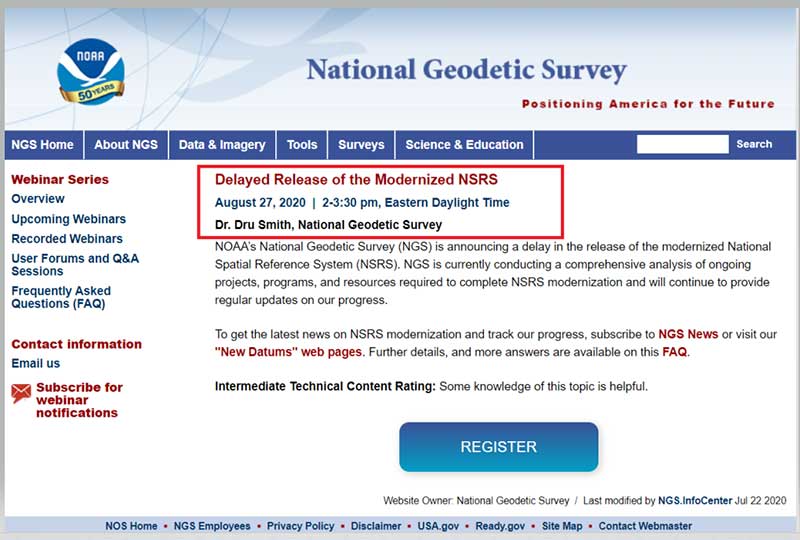
The National Geodetic Survey (NGS) recently announced two new items related to the modernized National Spatial Reference System (NSRS). First, it announced that there will be a delayed release of the modernized National Spatial Reference System (NSRS). See the box titled “Updates notices from NGS Homepage” for the link to the notice.
The box titled “Delayed Release of the Modernized NSRS” provides a summary of the notice. The announcement stated they are performing a thorough review of all tasks and will provide regular updates on their progress. What this means is that the modernized NSRS will not be completed by 2022. Even if it’s delayed a couple of years, it’s never too early to obtain an understanding of the new, modernized NSRS, and start preparing for the transition to the new NSRS.
NOAA’s National Geodetic Survey (NGS) is announcing a delay in the release of the modernized National Spatial Reference System (NSRS).
In 2007, NGS began planning for the modernized NSRS, acquiring its first airborne gravimeter, creating and initiating the Gravity for the Redefinition of the American Vertical Datum (GRAV-D) project and by 2008 had codified its modernization plans into a Ten Year Plan. At that time, the target completion date was 2018. By 2013, that date seemed unlikely, due to both the broadening of the GRAV-D coverage area and the experience of five years of operational planning and execution.
In 2013, NGS revised its 2008 Plan, and targeted 2022 as the date of the release of the modernized NSRS. This date was reinforced with a 2018 Strategic Plan revision. By 2017, confidence in hitting the 2022 target was high enough to reach final agreement with Canada and Mexico on a naming convention for certain components, to include “2022” in their names.
Since 2017, operational, workforce, and other issues have arisen and compounded, causing NGS to recently re-evaluate whether a successful roll-out by 2022 is possible. The most significant impacts have been in workforce hiring and retention, and in meeting GRAV-D data collection milestones, which underpin the NSRS modernization efforts.
NGS is currently conducting a comprehensive analysis of ongoing projects, programs and resources required to complete NSRS modernization and will continue to provide regular updates on our progress. To get the latest news on NSRS modernization and track our progress, subscribe to NGS News or visit our “New Datums” web pages.
The second important announcement by NGS was that two Federal Register Notices related to the modernized NSRS were published on July 24. See the box titled “NGS News.”
Image: National Geodetic Survey
The first Federal notice was titled “Upcoming Changes to the National Spatial Reference System.” See the box titled “Federal Register Notice titled Upcoming Changes to the National Spatial Reference System” for the summary. This announcement provides a statement about the new, modernized NSRS and that it’s going to be published between 2022 and 2025. The information about the modernized NSRS shouldn’t be new to anyone that’s been reading my newsletters, but the Federal Notice makes it official and NGS provides dates of when the modernization will be rolled out.
Federal Register Notice titled “Upcoming Changes to the National Spatial Reference System”
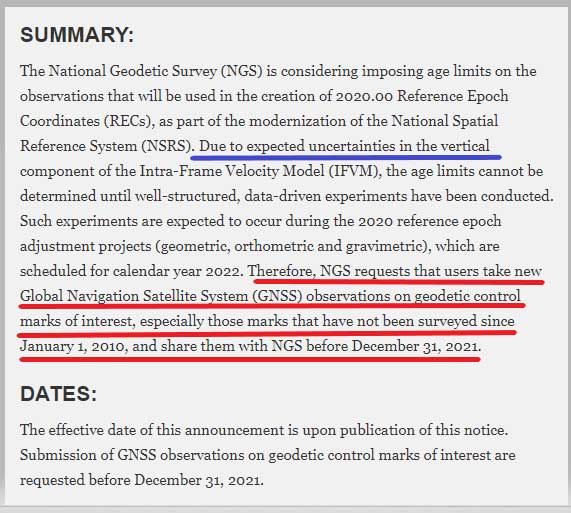
The second Federal Notice was titled “Consideration of Potential Age Limiting Observations To Be Used To Compute 2020.00 Reference Epoch Coordinates in the National Spatial Reference System.” This is a very important notice that users of NGS published coordinates should read and understand. NGS is considering imposing data age limits that will be part of the new, modernized NSRS. See the box titled “Imposing Age Limits of Data in 2022” for a summary of the Federal Register Notice announcement.
My last column highlighted that in the modernized NSRS the only way to get “into the datum” will be through a GNSS survey. It noted that leveling projects generate relative height differences not absolute heights. It emphasized that in the new modernized, time-dependent NSRS, the absolute height will be provided by up-to-date GNSS data; and the relative height differences between leveling marks will be provided by the leveling data. Many of my previous newsletters have explained different aspects of the new NSRS and how it may affect the surveying and mapping community products and services. As the Federal Register Notice implied, at this moment, NGS expects large uncertainties in the vertical component of the Intra-Frame Velocity Model (IFVM) which will translate into the GNSS-derived height Limiting the age of data will help to reduce the amount of uncertainty in the vertical component based on older data. Saying that, this could have an impact on users that rely on coordinates established using data acquired prior to 2010. NGS is requesting that users take new GNSS observations on all stations of interest that haven’t been occupied since the year 2010. The supplementary information in the Federal Register notice contains some very important statements. I have highlighted several statements in the box titled “Supplementary Information from Imposing Age Limits of Data in 2022.”
NGS hasn’t decided on the date of the age limit but the notice states that “For instance, it is unlikely that such an age-limit will be fewer than 10 years.” This is why NGS recommends the following “that users take new GNSS observations on geodetic control marks of interest that have not been surveyed since January 1, 2010, and asks the users to submit the observations to NGS before December 31, 2021.” Another important item in the supplemental information section is that NGS is enhancing the OPUS-Projects tool to include real-time kinematic and real-time network (RTK/RTN) observations. This should help to facilitate users submitting data on marks of interest so that they will have 2020.0 Reference Epoch Coordinates (REC).
Supplementary Information from Imposing Age Limits of Data in 2022
SUPPLEMENTARY INFORMATION:
In 2017, the National Geodetic Survey (NGS) announced its plans to estimate RECs on a five-year cycle in NOAA Technical Report NOS NGS 67, 2019, starting with the first reference epoch at 2020.00, as part of the modernization of the NSRS. In the Technical Report, the exact observations to be used for this estimation were listed as “To Be Determined.” NGS is considering imposing age limits upon the observations that will be used, particularly because of expected uncertainties in the vertical component of the IFVM. These age limits cannot be determined until additional well-structured, data-driven experiments are conducted. Such experiments are expected to occur during the 2020 reference epoch adjustment projects (geometric, orthometric, and gravimetric), which are scheduled for calendar year 2022.
However, since the cut-off for new observations to enter those adjustment projects is December 31, 2021, any decision to age-limit input observations will come too late for submissions to impact the 2020 RECs. While the cut-off for age-limited observations is unknown, certain assumptions are safe to make. For instance, it is unlikely that such an age-limit will be fewer than 10 years. Older observations may be used in the estimation of 2020 RECs, but this cannot be guaranteed. As such, NGS requests that users take new GNSS observations on geodetic control marks of interest that have not been surveyed since January 1, 2010, and asks the users to submit the observations to NGS before December 31, 2021. Users may either (a) submit existing unsubmitted observations through the OPUS-Share tool or (b) conduct new GNSS observations and submit the data to NGS via the OPUS-Share tool.
In order to increase the submission of GNSS observations on marks, NGS is prioritizing the finalization of an expanded OPUS-Projects tool, which will allow real-time kinematic and real time network (RTK/RTN) observations to be submitted, rather than the standard four-hour observations required in OPUS-Share. Initial roll-out of this new tool is expected to occur during calendar year 2020.
This action is designed to increase both the number and the coordinate accuracy of geodetic control points, which in the modernized NSRS will have an estimated 2020.00 REC. Historically, NGS has combined data across multiple decades to estimate geodetic coordinates, yet such efforts have not fully accounted for the lack of information about vertical motion of geodetic control points throughout the years. Since height information is critical to the understanding of floods, failure to compute heights accurately can have negative impacts on property and lives. NGS views periodic re-surveys of geodetic control points, rather than the estimation of coordinates from observations that are years (or even decades) old, as the most effective way to maintain accurate and up-to-date knowledge of geodetic coordinates, including heights. As such, this announcement provides users of the NSRS with advance notice that geodetic control points of interest to them should be re-surveyed for the most accurate representation of geodetic coordinates, including heights.
NGS has scheduled a webinar for August 27, 2020, to discuss the delayed release of the modernized NSRS. See the box titled “Webinar on Delayed Release of the Modernized NSRS” for the announcement and web link to register for the webinar. I would encourage all users of the NSRS to register for this webinar.
Many users are probably wondering if the delay in the new, modernized NSRS will change the dates of other deadlines. The FAQs webpage addresses some of these questions. I have highlighted a few FAQs in the box titled “Questions from NGS FAQ Website.”
How will the delay affect the GPS on Benchmarks Phase II deadlines?
The deadline for submittal of GPSonBM data for the 2022 Transformation tool will remain December 31, 2021
If SPCS2022 zone designs are completed before other parts of NSRS modernization, will SPCS2022 be released sooner?
No. SPCS2022 is explicitly defined with respect the four 2022 terrestrial reference frames (not NAD 83), and SPCS2022 will be released along with the roll-out of those frames. If the frames are rolled out prior to other parts of the NSRS modernization, the frames will be accompanied by SPCS2022 (see the previous FAQ about phased roll-outs).
However, complete definitions of all SPCS2022 zones will be made available as soon as they are finalized. NGS expects that to occur by the end of 2021. Providing zone definitions early will give software vendors, database administrators, and others ample time to adopt and test them in their systems. Doing so will ensure SPCS2022 is available for immediate use upon roll-out of the 2022 terrestrial reference frames.
My projected height change seems to return me to NGVD 29 heights. Is this a coincidence?
This is coincidental. It so happens that, in some areas of the country the actual orthometric height in a region happens to be numerically closer to NGVD 29 than NAVD 88. NGVD 29 itself has biases and tilts which make it as inappropriate of an estimate of true orthometric heights as NAVD 88
[NOTE: I have heard this question from many of my readers so I provided an approximate estimate of the differences between NAPGD2022 orthometric heights and NGVD 29 height values in my June 2017 Survey Scene column. See figure below labeled “Figure 2 from June 2017 Survey Scene Newsletter.”]
Image: National Geodetic Survey
Figure 2 from June 2017 Survey Scene Newsletter
Future newsletters will address updates on the modernized NSRS as they become available to the user community.
New players are offering GNSS correction services — pushing prices down and offering new business models. What opportunities does this open up?
Jules McNeff
“This trend is encouraging, as new entrants bring energy and new ideas, keeping the PNT technology sector fresh. GNSS corrections enhance the value of dynamic mapping coupled with grid-coordinate systems such as the U.S. National Grid in producing user-friendly geolocation values for delivery of people and things and especially enabling efficient, precise, land mobility activities such as spatial awareness for autonomous vehicle movement and command and control of emergency response operations.” — Jules McNeff Overlook Systems Technologies
Greg Turetzky
“In a 5G world where most devices regardless of size are connected, it make sense that those devices that are mobile are going to need to be located. Correction services are key to providing enhanced accuracy, and new business models are needed to address these new markets that are fundamentally different than traditional high-accuracy markets.” — Greg Turetzky Consultant
Jean-Marie Sleewaegen
“Traditional correction services rely on bidirectional communication between a user and a local correction provider. They offer centimeter accuracy over small regions. Instead, new services broadcast corrections applicable to larger areas and with flexible accuracy levels, from centimeters to decimeters. They bring benefits not only in pricing, but also in terms of accessibility, scalability and ease of use. They make accuracy transparent to the user, opening up the opportunity of high accuracy to mass-market and industrial applications.” — Jean-Marie Sleewaegen Septentrio
The Mark 3 Plotting Board was used in single-seat aircraft flying in the Pacific. (Photo: National Air and Space Museum, Smithsonian Institution)
On June 25, 1945, in the last few months of World War II, troops from around the globe were headed home and navigation technology was in its infancy.
On that date, the first organization meeting of the Institute of Navigation (ION) took place on the Los Angeles Campus of the University of California with 55 people in attendance. A temporary organization was established to carry on until the fall, when a second general meeting would take place on the east coast.
The first ION Annual Meeting was held Oct. 25–26 that same year at the Hotel New Yorker, with 95 ION members and 35 non-members attending. Proposed Articles of Incorporation were adopted and a council was elected.
By late October, two organizational meetings, two regional meetings and the annual meeting had taken place; bylaws were adopted with plans for incorporation; a permanent organization was established; a National Office was set up at UCLA; and plans were made for future meetings and publication of a journal.
ION’s global impact is documented in more than 2,600 technical papers published in Navigation, the Journal of the Institute of Navigation, first published in March 1946.
On June 25, ION wrote to its members, “Thank you to the thousands of ION members who have committed themselves to our field; and thank you for 75 years of technological advancements that have helped us all discover where we are, where we are going, and when we will get there.”
Last week, 27 members of the U.S. House Agriculture Committee sent a letter to Federal Communications Commission (FCC) Chairman Ajit Pai. In it, they urged him to reconsider the FCC’s decision to allow Ligado Networks to operate a terrestrial nationwide network that the executive branch says will cause harmful interference to GPS signals for many users.
This concern and opposition from a sector not traditionally engaged in GPS or positioning, navigation and timing (PNT) issues is just one example of how the FCC’s decision — rather than putting the issue to rest — has instead recruited a whole new set of actors from across multiple sectors for the opposition.
Many observers don’t see this as surprising.
According to one observer, previously it was easy for many to assume the FCC would reject Ligado’s proposal. The entire executive branch had been vehemently opposed for years. So had aviation groups, the weather community, geospatial interests and some satellite communications concerns. With such opposition from so many important quarters, it was reasonable for many to assume they need not become involved. Now that the FCC has acted to the contrary, these interests have become well energized.
The FCC decision also empowered opponents to educate and recruit others who don’t normally think or worry about GPS and PNT issues, folks like farmers and agricultural interests.
As one insider said, “The existing opposition can now go to just about anyone in any sector and say, ‘This is going to happen and it will harm your operation. There are no ifs, ands, or buts. The FCC has decided’.”
Photo: Avalon_Studio/E+/Getty Images
Agriculture’s reliance on GPS
Agriculture is a good example. While not the sector that first springs to mind when most people think about GPS, farming has become dependent on augmented GPS for precisely and automatically driving machinery, minimizing fertilizer and pesticide use, and a wide variety of other productivity gains over pre-GPS operations.
“GPS is critically important to the commercial agriculture, mining, forestry and rural manufacturing industries. In fact, GPS has become the single most significant technological advancement for American farm equipment in the past two decades… [A 2019 RTI study] found that during planting season, if GPS were interrupted, the economic impact to the agriculture sector could amount to losses of $15 billion due to lower crop yields. Moreover, an earlier study suggested GPS-enabled precision agriculture could save farmers an estimated 10 to 15 percent in operating costs and purchased inputs. This same study estimated the benefits of GPS to precision agriculture between $10 and $17 billion.”
Department of Transportation studies have shown that high-precision GPS receivers, such as those used in agriculture, could be impacted within 3,000 meters of a Ligado transmitters. With tens of thousands of transmitters deployed in a nationwide network, this could pose a real problem for American farming.
Other sectors have also become involved in the opposition. The recently formed Keep GPS Working Coalition has members representing aviation, surface transportation, maritime, agriculture and equipment manufacturing.
This formal and public coalition, though, seems to be just the tip of the opposition iceberg.
Almost 100 dissenting organizations
According to some involved with protesting the FCC’s decision, there are nearly a hundred organizations and companies that are working in some way to have it overturned. These include multiple aviation, delivery service, agriculture, surface transportation, geospatial, weather, maritime, space and technology interests.
One sign of the influence they are having is an increase in concerns being expressed by members of Congress.
In addition to the agriculture letter, some of the most powerful recent examples are statements made during meetings of the influential House Committee on Appropriations. Rep. Ken Calvert (R-CA), ranking member of the Defense Appropriations subcommittee, spoke at length in opposition to the FCC’s action. His comments were followed in a similar vein by the vice chair of the Appropriations Committee, Rep. Peter Aguilar (D-CA).
Many of the questions being asked by the public and members of Congress alike were reflected in the letter from the Agriculture Committee members:
How did the FCC know that “its” tests were representative and valid?
Why does the FCC find that some degradation of GPS reception is acceptable?
Why did the FCC reject the executive branch’s testing criteria?
Was there a cost/benefit analysis?
The letter also asked the question that is on almost everyone’s mind: If and when there are problems, who is going to fix them?
By David Zilkoski, contributing editor, survey scene
David B. Zilkoski
I attended The Ohio State University (OSU) to obtain my graduate degree in Geodetic Science in 1979. Therefore, I will admit that I am a little biased — once a geodesist, always a geodesist. The basic definition of geodesy is the applied science for determining the size and shape of the Earth, designing and realizing reference frames, and determining where you (and anything else) is on the Earth.
In OSU’s geodesy heyday (1960–1990s), many Americans trained were sent by federal agencies: National Geospatial-Intelligence Agency (NGA), NOAA/National Geodetic Survey (NGS), USGS, Army, Navy and Air Force. During the 1970s, NGS was sending two employees back to school every year. These agencies needed geodesists because they were undertaking major projects such as NGS’ to readjust the U.S. national horizontal (NAD83) and vertical geodetic (NAVD88) networks.
I was one of the employees that NGS sent to OSU to be trained to support the NAD83 and NAVD88.
The advancements in satellites and computers have enabled geodesy to expand into many different disciplines. Geodetic science and technology now underpin many sciences, large areas of engineering (such as driverless vehicles and drones), navigation, precision agriculture, smart cities and location-based services. Geodesy is actually more important than ever.
Today, the environment is different. U.S. federal agencies still need geodesists for developing enhanced and refined geodetic models and tools. However, major U.S. companies, such as Google and FedEx, as well as the automobile industry, precision farming companies and mining companies also need more accurate geodetic models, tools and algorithms. Therefore, these companies also need trained geodesists to perform important research on topics that address their specific geodetic requirements.
Today, OSU’s Geodesy Department is training very few American citizens. As the U.S. moves toward achieving geodetic-grade positioning in real-time in support of new applications such as driverless vehicles and drones, the number of trained geodesists should be increasing, not decreasing [Note: In 1990, there were 92 geodetic science graduate students. In 2019, there were 25; only three were U.S. citizens]. OSU and other universities need to educate and train the next generation of the nation’s scientific workforce of highly skilled research geodetic scientists that will expand industry’s research expertise.
The shortage of American geodesists poses a significant economic risk for the U.S. Europe and China train many more geodesists than the US. There are very few geodetic science programs in the U.S. today, and education in geodetic proficiencies has been fragmented. The OSU graduate program is one of few surviving geodetic science programs.
Users of geodetic products and services need to support geodetic departments in universities so that U.S. geodesy programs can grow to meet the geospatial demands of the future. The geospatial component of the economy is worth about $500 billion/year. So why are we allowing its foundational discipline to shrink in this country?