UAV developments are taking flight across the globe.
In one development, older technology might enable new capabilities for a pseudo-satellite UAV. Meanwhile, new technology adds significant landing capability to an Air Force drone. Finally, further trials are expected to help develop drone operational procedures and regulations in India.
Spain’s Skydweller moves to Oklahoma
An unmanned aircraft builder from Spain — Skydweller — is setting up operations in Oklahoma. This latest outfit to relocate is establishing its headquarters in Oklahoma City to develop a pseudo-satellite vehicle with a large payload capability.
For anyone who has kept tabs on the Airbus Zephyr, the UAVOS ApusDuo, The Aurora/Boeing Odysseus, or the Softbank/AeroVironment Hawk30 high-flying drone programs, you might have noticed that the stratospheric pseudo-satellite business is not easy. None have yet made it to true operational status — loitering for months at +60,000 feet and living off only sunlight, while carrying significant payloads to provide communications services. That said, some trials to date have apparently been quite successful.
All those existing UAVs are huge, flimsy, flex-wing aircraft that take an inordinate amount of care to handle in the difficult phases of take-off and landing. Airbus’ second prototype crashed in Australia in October 2019, and several other companies’ earlier prototypes have crumpled somewhat when they inadvertently contacted the ground.
Now enter Skydweller. Skydweller is designed to carry a relatively large payload and fly persistently in the stratosphere.
The payload includes one or more communications relays: 4G/5G cellular, day/night full-motion video, satellite communication, and imaging radar. This looks like it could be one capable vehicle. The makers hope to capture business in commercial and government telecommunication, geospatial, meteorological and emergency operations. Skydweller has apparently been around since 2017 and has a lot of capability, so let’s see how they do with their new venture in Oklahoma.
If you were wondering where this technology came from, it is today’s carry-over of the famous around-the-world flight by the Solar Impulse aircraft from 2016, which circled the globe without fuel, using electrical power generated by solar cells on its wings.
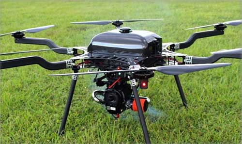
GA Makes Improvements with Reaper
In another life, I was quite attuned to what it took to “automatically” land a passenger jet, so a recent release from General Atomics (GA) about improving the auto-landing system on Reapers (new-generation Predators) caught my eye. GA has a U.S. Air Force contract to update these unmanned reconnaissance/attack drones with the latest and greatest, so making a working system better is one of those improvements.
Actually, GA made three changes. The first enables the drone to divert to an alternate landing zone if the planned landing area is compromised — another word to express the possibility that hostile action or weather forced home base to send the vehicle elsewhere. Quite clever, in that the alternate site might not have a ground control station, along with someone who can fly the aircraft.
MQ-9A Reaper drone, (Photo: USAF)
The ground pilot at home base has to either enter coordinates for the new alternate landing zone and the aircraft flies there and lands itself, or he needs to overfly the landing zone so that the Reaper can collect its own waypoint with which it can automatically align and land.
The second improvement has increased the speed limit of the cross wind in which the drone can land
The third enhancement allows the drone to land heavier than previously — both essential elements of being able to divert in an emergency, when weather may be poor and the aircraft could be carrying unused ordnance and fuel.
All this is a far cry from landing civilian air transports with GPS-based guidance, which is much more restrictive and with a whole mess of mathematical probabilities of the unlikeliness/likeliness of failure. Not so much for a Reaper drone on a mission during a “time of unrest.”
Home Deliveries in India
For those of you eagerly waiting for Amazon to start speedy deliveries of your online orders by drone, or Grubhub to drop in with an order of curry in a package dangling from a friendly unmanned air vehicle in your yard, there may be hope… especially if you live in India.
Following our earlier report of anticipated food deliveries by drone in India, more trials are leading to regulations and control systems. Altitude Angel from the United Kingdom has teamed with Indian Sagar Defence Engineering for a series of beyond-visual-line-of-sight (BVLOS) drone trials.
Altitude Angel’s GuardianUTM platform will be used to monitor and control these flights through real-life scenarios. Scenarios include medical and cargo transport, surveillance operations, survey and mapping, and search-and-rescue operations. Sagar will operate the cargo carrying drones; feedback from the GuardianUTM system will enable the BVLOS flights.
While the Indian government has begun to grant permission for some commercial UAV undertakings, the intent is apparently to use the output from the Sagar/Altitude Angel BVLOS trials, taking place August through October, to help develop regulations for safe operation of drones over increasingly longer distances in Indian airspace.
To sum up, intellectual property from an around-the-world photo-voltaic airplane may become a substitute for low-cost satellite TV and Wi-Fi, while auto-land is old hat for a Predator cousin and the Air Force has gained even greater landing flexibility for a principle recon/attack drone.
Finally, we can expect at least one continent to get to regulations that allow drone deliveries to become a reality at last. As usual, there is a lot cooking in drone-land….
By Alexander Meisel, automotive cybersecurity engineer at intive
Alexander Meisel
When it comes to connected cars, automakers are innovating fast. Consumers are experiencing increasing amounts of futuristic features, be they passenger connectivity, automated speed regulation, or autonomous driving capabilities.
However, these innovations and their integration with cloud connectivity come with a heightened risk for cyber attacks. A recent study conducted by U.K. self-driving hub organization, Zenzic, found that becoming cyber-resilient will be the biggest technical obstacle to successfully deploy self-driving cars on roads by 2030. This mountain will be a big one to surmount, and it’s only growing in size: The auto industry has seen a 94% year-over-year increase in hacks since 2016.
So, how can automakers prioritize security while keeping up with the demand for innovation in today’s connected cars?
Carmakers must consider security from day one
To make sure that security is built into the very foundations of a car, automakers must make it a priority from the first day of design. This focus is lacking amongst carmakers at the moment. In fact, 19% respondents to one survey said they don’t do enough security testing in the design phase, and only 28% said that they do a lot of the testing during the design stage.
Automakers can use design principles to build in security from the outset. For example, the principle of complete mediation allows for enhanced security as it ensures that a software stem “requires access checks to an object each time a subject requests access.” This means that attackers are only invited to exploit a system on one single occasion due to checks on subjects’ permissions.
Carmakers can also ensure that they are not sacrificing security by considering its importance when purchasing components from separate suppliers. These components must be specific enough to enable security in the system, but generic enough to allow for innovation.
Here, companies can leverage the software engineering principle of interface segregation. This means that a shrunken, clear interface should be supplied by the vendor, so that the customer only uses the methods that are of interest to them. In turn, this allows systems to remain decoupled and thus easier to then build a rich interface on top of. However, carmakers will have to stay on top of the security of the part in the development phase, and ensure that dormant functions are not abused by at least logging their execution once somebody tries to call them out of context.
Developers and cybersecurity experts must become a core part of the team
Software development is relatively new territory for carmakers. Now, cybersecurity is a key component of building connected cars, and automakers need to embrace developers that have expertise in this area and make them part of the core team.
This cultural change must be championed by the business leaders to allow car security to advance alongside the innovative features that the industry is building. This can be done by implementing DevSecOps ideology into the team, in order to “build the mindset that everyone is responsible for security.”
Car development teams will likely need a group of cybersecurity experts who can educate the rest of the developers and are willing to participate in the development process in order to check and implement safe and secure functions. If a company doesn’t have this kind of expertise in-house, they can partner with an expert third-party to help them along this journey.
Innovation and security can complement each other
Cybersecurity doesn’t mean sacrificing feature innovation: developments are being made in the field of security too, such as biometric technologies that can be integrated into car design.
For example, Blackberry’s QNX technology “has built in concepts for hardware and software trust validation, hypervisor to maintain a separation between the safety critical and infotainment systems, and a core operating system which passes all the functional safety standards,” according to the company’s senior VP SVP, head of QNX, John Wall. Innovation need not suffer at the hands of security, and vice-versa.
In addition, the world’s leading electric vehicle provider, Tesla, ensures security in its cutting-edge, connected cars by sending security updates to cars’ operating systems overnight, and even providing awards for hackers that manage to hack its cars.
Looking ahead to the possibilities of autonomous vehicles (AV) that can drive passengers without needing to have their owner inside, innovation in GPS will be necessary to ensure security and accountability of the car. Potential AV thieves would first look to use GPS data to disable or falsify a car’s GPS system, making it untraceable.
However, carmakers can make this impossible for hackers by not just logging the data in its raw form, but also combining it with other car data using cryptographic algorithms. This ensures that the GPS data remains traceable even after the hardware has been taken apart and sold on the auto-parts black market. In this way, the signature of the original data combined with the GPS position adds an additional layer of security.
Integrating security into connected car design is no simple feat, but it’s a necessary one for carmakers that want to ensure the safety of their passengers while on the roads. By using design principles, diversifying expertise within development teams, and understanding that security and innovation need not be a trade-off, they can do just that.
Alexander Meisel is an automotive cybersecurity engineer at intive. Alexander has a Computer Networking diploma from Hochschule Furtwangen University, and he has developed as a CTO and Development Team Director in previous companies. He has experience with venture capital, successful M&As, product and technical marketing strategies. Meisel is also a public speaker at technical conferences and trade shows.
Everywhere we look, data is being collected, reviewed, analyzed and stored. It used to be that data was a static piece of information, like a piece of paper in a filing cabinet. Millions of pieces of data being created yet almost all of it never to be used again. The computer and electronic storage began a revolution of how we warehouse this information but that was only the beginning. Technology has turned data into a living, breathing beast few understand yet it controls most of our lives in various ways.
Mapping of the earth has not always been about establishing boundaries and parcels; many of the early maps and plats were created to depict the topography of our world. While there are some indications that Middle East maps depicted parcels, the first examples of topographic maps were created during the Roman Empire era of 300 A.D. It is common knowledge that the Romans utilized primitive yet cunning engineering for roads, buildings, and waterways but it was the initial topography that was mapped that allowed them to design those forward-thinking infrastructure components. Because of the lack of sophistication in the measuring methods and data collection, these topographic maps covered small areas and often crude because of the materials available. Considering what they were working with, it is still incredible what they were able to map, design and build.
Measuring devices and methods of data collection expanded over the centuries like most occupations and professions. By the 16th and 17th century, mathematics has been introduced at a wider scale through many educational facilities. Another profession, geographers, also advanced with the evolution of measuring devices and mapping techniques. It was during this period that we began to see a crossover with surveyors with geographers to create topographic maps with greater accuracy and precision through triangulation.
In the 18th and 19th century, instruments became more sophisticated to assist in the determination of elevations and more accurate angle measurements. The concept of triangulation flourished during this period and significant mapping was made for most of the civilized world. The early 1800s saw the westward push of expansion in the United States and Thomas Jefferson, U.S. president and former surveyor, led the charge to map the existing states and divide the west into sectional land for sale to settlers.
Besides the establishment of the Public Land Survey System, surveyors also provided topographic information for map of all sizes for future development planning. The late 1800s brought a large amount of topographic mapping information to paper through efforts by the U.S. Geological Society to map the entire United States. This information has been called the first land database; although crude in overall nature compared to today’s standards, it contained an enormous amount of topographic information.
These surveys continued well into the early 20th century until a revolutionary invention coupled with a current technology merged: the use of a mounted camera taking aerial photographs from an airplane. Geographers and photogrammetrists were able to use surveying data to assist with scaling orthometric photographs to create aerial images of thousands of acres of land. These aerial photos became the base layer for determining topographic features and contouring, covering much more land than ever before. Additional innovations included advancements in stereo plotting and photogrammetric techniques to further create high sophisticated topographic maps for the era. This type of mapping was the gold standard for decades depicting existing condition and topographic features for most of the world until the early 1970s and the computerized data revolution.
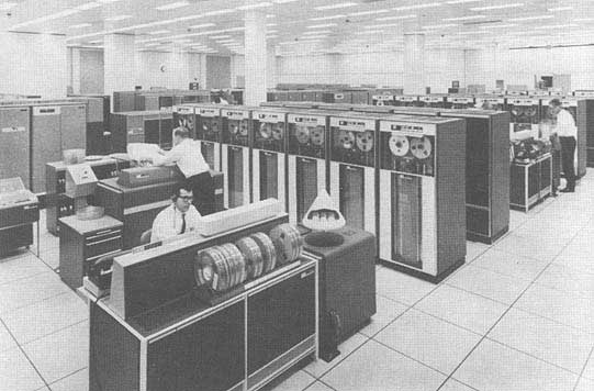
Computers take over the world (literally)
1960s mainframe computer (Photo: NASA)
While mainframe computers became more universally used in the 1960s, their use was contained to governmental agencies and large corporations. As the physical size of the computer reduced, the computing capacity increased, programming became easier to complete, and more applications were created to perform a variety of tasks. One of the biggest advancements for the era was electronic storage and analyzation of data through programming. Relational databases became a hot ticket for large datasets; geographic data was the perfect fit for this type of application. Modern mapping was on its way forward at warp speed.
Topographic mapping was not lost in this shuffle. The survey itself is based upon data points located on the face of the earth so each point is just another chunk of information within the database. Programming continued to advance and soon methods previous completed by manual methods over long periods of time were completed in a fraction of previous efforts without fail.
This effort was also joined with advancements in graphical technology to display this data on a computer video screen instead of lines of green text and numbers. Vector-based graphics, together with enormous point databases, helped create large topographical and geographical maps for many uses. During the same time the US put a man on the moon, mapping and platting of topographic information was also out of this world.
The turn of the century brings big changes
For the next decade, there were small advances in technology for topographic surveys and data points, but most were in presentation of data and increases in computing power. Pen plotters and smaller yet more powerful computers were becoming affordable to smaller companies, but it was still a large investment to get into the computerized data game for a surveyor. By the mid-1980s, electronic data collection with a total station was becoming the norm, but only meant collecting more points in a more efficient timeframe. The computing component did get faster but is still producing the same information of static data points.
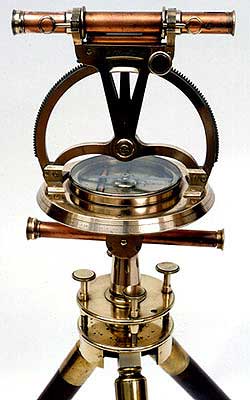
Ancient techniques and new technologies (Image: ngs.noaa.gov)
The mid-1980s also brought us a shiny new object: GPS technology. By the end of the 1990s, we were able to get out of our vehicle, start the receiver and collect geolocated points in minutes rather than hours. The big takeaway from this advancement is the geolocation component of the data point. Now everything can be related to one big dataset of topographical points. By creating a database with all our project data collected in the same georeferenced datums (horizontal & vertical), we can create digital models that replicate existing conditions.
We can also add another big advancement in data collection: remote sensing technology. From laser and lidar scanners, photogrammetry, SLAM technology and ground penetrating radar, the innovations to collect data at locations we can “see” through sensing are now a reality. Another significant improvement with this technology is the amount of data points remote sensing can collect, both in timing and spacing. We are now talking small scanning projects that consist of billions of points within the site point cloud. We are fortunate that our computing power and storage capabilities has increased exponentially along with the remote sensing. (Remember doing a “regen” on your CAD file and having time to get a cup of coffee?)
Lots of data — now what?
Data is powerful, especially when it is harnessed in a robust system that can analyze and model for future use. Yes, this condition also applies to the surveying world, even though you may not be thinking about it now. We can use this data to create a virtual world that mimics the one we live in; the difference is that we exist in ours yet model and manipulate the digital version in our computer system. The technology is now available, and we can make a replica of our current world; however, why would we want to do that? There are lots of reasons to use technology and data to make sophisticated topographic maps (because that is what they are) for recording the world around us.
One of the big differences now is that we have much more information about the data points we collect within our topographic maps. Sure, many surveyors will say that their data has not changed or evolved during their careers, but they would be wrong. Unless they are still manually writing it all down for hand plotting… (Hello! The 1960s called, and they want their field book back!) Every electronically collected point has attributes associated with the data.
These attributes, while they may be simple, contain important information about the datapoint it represents. Horizontal location? Check. Vertical elevation? Check. Assigned point number? Probably. Field code? Most likely. But it also has one other important component: time. We now know exactly when that point was collected. Why is that important?
Because, like a lot of instances, things change. Something collected today might not be there tomorrow. Time is just as important as the physical location and the type of point it represents.
Gather these points together, throw them in one big model and you have yourself a graphical database that can be analyzed, reviewed, and used for planning and design. It may be hard to visualize with just simple survey data using GNSS and/or a total station, but couple it with a scanner or photogrammetry, you have a powerful hunk of data for which to work.
Why is this workflow and modeling procedure important enough to dedicate an entire column about surveying and GNSS to? Because it used to be far in the future, but the need and availability to use it is now here in front of us. Surveying and GNSS are an important part of this effort to create three dimensional models. By using survey-grade data in conjunction with point clouds collected from remote sensing equipment, we can replicate the world around us in real time.
Yes, Virginia, there is a name for the modeling process…
Photo: iStock.com/alexsl
The name for the proposed modeling of this dataset is a digital twin. It represents a digital representation of a physical object or system. NASA famously used the concept for their space program to simulate situations and procedures of many different types of events. The concept has grown with the technology to graphically create almost anything through digitalization and computer modeling. Once the model is created, both actual and proposed data points can be included to represent the existing and future opportunities.
The idea of a digital twin is not new; technology, however, has pumped more life into its existence by leaps and bounds with computing power and data storage capability. I remember, early in my career, going into an architect’s office and seeing the scale model mockup of a new development or building. The streets in the model were perfect, there were no drainage issues, and it was a neat as a pin. Fast forward to the construction of the development and field changes were at every turn. A digital twin will allow for better planning, more thorough design and creating more cost-effective development. Many large cities have started compiling data and building their digital twin, including New York, Singapore, Boston, and Rotterdam. Engineering and planning for new and replacement facilities is very expensive yet analysts predict that having a digital twin to work will save a significant amount of money and time.
As a surveyor, what’s in it for me?
Software capability for the surveyor is already here. Companies, such as Hexagon, Trimble, Topcon and Esri to name a few, have been developing their software to accommodate this concept for many years. Still, lots of surveyors do not know about it. And we should. Many of us live in places where the infrastructure is well past its useful life period and should have been replaced long ago. By starting now with survey-grade data to be put into a real-time model, we can help our governmental agencies and their consultants to move towards a digital twin that will ultimately save money and possibly lives.
What this means for the surveyor is to further embrace technology and include remote sensing into your operation. If you have not started at least looking into UAVs and photogrammetry, you are already behind. Many aerial operations are making the next leap into mounting a LiDAR unit on their UAV to gain even more capability. Early adopters of laser scanners were probably second guessing their decision during the 2008 Depression but if they stayed with it, it will be a big payoff in the long run. The next leap will be into handheld scanning devices, including ones using SLAM (simultaneous localization and mapping) technology for locating interior and close-up improvements. These technologies will cost a significant amount of time and money to implement but municipalities, engineers and architects are going to be clamoring for the data any day now.
When it comes to surveying and mapping of existing facilities, the surveyor and technology makes a great team. Do not let point clouds, remote sensing, or terabytes of data scare you away from providing badly needed information to help assemble your local digital twin. In the long run, it will pay off for all who take on the challenge of building it.
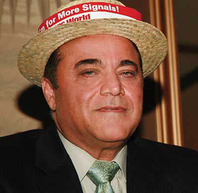
Dr. Javad Ashjaee, Founder and CEO of Javad GNSS, 1949–2020. (Photo: Javad GNSS)
The GNSS community was deeply saddened by the loss of Dr. Javad Ashjaee — Javad, as he liked to be called — on May 30. Following are excerpts of comments by GPS World Editorial Advisory Board members and others, all of whom also expressed their heartfelt sorrow.
Message from The Ashjaee Family
“Once in a while an individual comes along with a spirit seemingly superhuman, a resolve and constitution seemingly indestructible. Dr. Javad Ashjaee was one such individual. His talent, intellect, commitment and sheer guts were head and shoulders above the rest, much to the chagrin and frustration of his competitors and naysayers. But those closest to him know that he was also simply, beautifully, erringly human. He brought out in the rest of us the strength and wisdom we could not always see in ourselves. Yes, he was a force of nature, as many describe, but Javad never did anything alone. Throughout the years, he has had a sizable family and team, by blood as well as by love, behind each of his many achievements and contributions to his field. He once told us his name, Javad, means ‘generous.’ And that he was. All that he has given to, and all that he has inspired in, his family, team, and professional industry, forms a legacy that will continue for years to come. We, his family, his team, his protégés and protectors, are here to stay and stronger than ever. If he were here, he would surely wonder how his competition would proceed without that fire only he could ‘light up their asses.’”
Jules McNeff VP of Strategy and Programs Overlook Systems Technologies
“Javad was a brilliant innovator, although he could be a bit infuriating at times. He loved to place ads in GPS World in part to poke fun at the DoD for our Selective Availability policies, for which I was the principal defender at the time. Javad was a unique and talented person of tremendous fortitude and intellectual confidence who was never afraid of controversy. The GNSS community will miss his energy.”
Mitch Narins CISSP/FRIN Strategic Synergies
“When I think of Javad, the words that come to mind are ‘brilliant, dedicated, driven, and committed.’ The last time I saw Javad at an ION GNSS+ conference, he knew he was on the side of an argument opposing many other experts in our GNSS community. That did not bother Javad. He was never one to go along to get along — which was one of the reasons he was able to develop such innovative and capable systems. Our GNSS community has lost a leader, innovator and contributor to the science and engineering behind position, navigation and time.”
Paul McBurney Ph.D., CTO and co-founder OneNav
“Javad was a one-man army who was not afraid to fight. From his days at Trimble, where he developed major advancements in receiver software, and through all of his endeavors, Javad produced an impressive amount of truly innovative solutions. He used the LightSquared crisis as an opportunity to add novel front-end filtering to his products, and cleverly marketed it. His writing was unmistakable, featuring the wordsmithing of both an engineer and a salesman. He was a role model to many aspiring GPS entrepreneurs.”
Tim Burch Director of Surveying SPACECO
“Javad’s contributions to the surveying profession helped turn every practitioner into a geospatial information provider. From his early days at Trimble pioneering the commercial-grade receiver to creating his company at Ashtech and embracing GLONASS with GPS, he continued to expand the capability of the GNSS receiver. Many surveyors today, however, only know his name through his latest company, Javad GNSS, and its unique line of receivers and measuring devices, with their distinct green color. Javad was a big part of the GNSS revolution, so the next time someone starts up his/her receiver to collect survey data, take a moment to thank him. His departure leaves a giant hole in the geospatial world.”
Michael Swiek Managing Director, Executive Branch and International GPS Innovation Alliance
“The ‘Original Cast’ of GPS innovators is dwindling. Javad was a complicated, self-made, innovative, and entertaining man. In the many years we knew each other, we worked on shared visions, many challenges, laughed a lot, and disagreed and argued more than a bit. We always remained friends, honest to each other. Javad was a true GNSS pioneer.”
Ellen Hall President and CEO Spirent Federal Systems
“What a loss for everyone. Such a talented person who truly made his mark on the world.”
Greg Turetzky consultant
Dr. Ashjaee leD the signals team of the “Satellites vs. Signals” after-dinner debate at the GPS World Leadership Dinner held during ION GNSS 2008. (Photo: GPS World)
“I have very fond memories of Javad from the many years we attended
ION GNSS+ and other industry conferences. I will always remember a spirited ‘Satellites vs. Signals’ debate we had at a GPS World Leadership Awards Dinner. We were equally passionate about the debate — despite not having chosen the opposite sides to which we were attached. These are the memories of Javad I treasure. He was passionate, informed, innovative and really good at playing the game. His spirit of innovation will be missed, but I am confident it will be carried on by other members of the GNSS community of which he was such an important part.”
Alison Brown President and CEO NAVSYS
“I am so sorry to hear about Javad’s passing. He was an innovator and an originalist. We worked together after he left Trimble and was in the process of starting Ashtech. I particularly remember his championing the cause, with me, against Selective Availability. He ran an ad with the iconic image of the Mona Lisa as part of this cause, with the slogan “Why ruin a work of art?” It is tragic that Javad fell victim to COVID-19. He will be sorely missed.”
As we bid farewell to the last GPS-IIA satellite and read of delays to both the launch schedule for GPS III satellites and roll-out of the OCX program, we are mindful of the need to maintain GPS as the “Gold Standard” in GNSS.
Certainly, new signals, enhanced resilience and expanded capabilities are offered by the modernized GPS playbook. Delays relative to both the BeiDou and Galileo constellations could seriously impact the position of GPS on the medals podium — maybe not in the longer term, but certainly in the coming few years.
This may have a secondary impact on the receiver market, shifting focus away from GPS to more capable signals in the near term. Once GPS has caught up, receiver manufacturers may choose to retain the technology that they developed to capitalize on BeiDou and Galileo signals, rather than developing their legacy GPS capabilities.
GPS L2C is currently “pre-operational,” transmitted by slightly more than half the existing mixed-generation satellite fleet and waiting for OCX support. As of Feb. 20, a realistic estimate for operational capability of GPS L2C is now 2023.
GPS L5 is also pre-operational, transmitted by slightly less than half of the GPS satellites and waiting for OCX support. As of Feb. 20, a realistic estimate for GPS L5 is 2027.
The forecast for GPS L1C operational capability is the late 2020s. This is intended to be the signal that offers international interoperability with the current interoperability signals offered by existing BeiDou and Galileo satellites.
Delays to the implementation of GPS L1C may mean that GPS misses the interoperability boat entirely. During the delay, new interoperability capability with even more robust signals could be devised and lofted aboard Galileo, BeiDou and GLONASS satellites. By then, other countries could also develop their own constellations, possibly regional or even global systems.
Potentially, GPS could be left behind as other nations discuss non-GPS internationally interoperable signals on yet-to-be launched satellites. This may have a profound impact on SBAS, too. Differential corrections provided by the Japanese MSAS, Russian SDCM and European EGNOS SBAS systems might evolve to support “beyond L1C” interoperability signals. Aircraft landings at world airports could mandate the use of corrections to these new signals. This might mean that U.S. receiver manufacturers could be frozen out, or will have to incorporate these new interoperable signal standards.
GPS Block III satellites along with OCX offer improved signals, capabilities and resilience, but the satellites need to be flying, OCX needs to be operational and receivers need to be in the hands of the users. Sooner rather than later is a must for Gold-Standard GPS.
Paul Crampton is a senior systems engineer at Spirent Federal Systems with more than 30 years of GPS experience.
A drone-versus-piloted attack aircraft, deliveries of medical supplies in North Carolina, unmanned meal deliveries in India and anti-drone protection for the Kennedy Space Complex are just a small sample of unmanned air vehicle news this month.
Even the U.K. BBC TV network picked up the news over the weekend that the U.S. Air Force (USAF) plans to pit an unmanned drone against a manned fighter aircraft, maybe even as early as July next year. The candidate fighter drone is thought to come from the USAF’s “Skyborg” research program — a wide ranging initiative aimed at incorporating artificial intelligence (AI) into unmanned vehicles which can out-think and out-fight the opposition.
The logic seems to be that if you could somehow ‘can’ all the experience of today’s pilots – somehow distill all their knowledge and stuff it into electronic memory and have AI use this data-base – then an unmanned fighter drone would somehow do better in combat against a hostile, manned aircraft. Probably a good idea, but how could it be made to work?
The Loyal Wingman in its first test flight. (Photo: U.S. Air Force 88th Air Wing Public Affairs)
And the prime candidate to try all this is out could be the “Loyal Wingman” which was recently rolled out by its manufacturer Kratos. With a target price-tag of only $2 million each (for qty 100), USAF apparently foresees a future with lots of these “disposable’”guys accompanying the manned F-18, F-35, F-22 and future fighters into battle. Perhaps the airborne pilot could even coach his unmanned colleagues through an upcoming dogfight, augmenting the onboard knowledge carried by the drone? Seriously Si-Fi sounding stuff, but its apparently already well on its way.
And would current day autonomous drone operations count as using AI? Well such a drone uses a GNSS nav system and an operator pre-programs a route prior to launch, which the drone then refers to when airborne — even dropping off a package on cue when it arrives at destination, and turning round to fly the same route back home. So referring to an on-board waypoint data-base and executing a beyond visual line of sight (BVLOS) flight on its own — its somewhat limited AI, but the drone is independently doing a task once instructed.
Which brings us to the recent pandemic-related operations that operator Zipline has just begun running out of Kannapolis, North Carolina – from a vacant lot near a Novant Health logistics center — to the Huntersville Medical Center. With only regular capability to operate in accordance with Part 107 regulations, Zipline applied for a waiver to not only fly around population centers, but also to fly beyond visual line of sight (BVLOS). The Federal Aviation Administration (FAA) granted emergency authorization for Zipline to support Novant’s hospital and clinic COVID-19 response.
Fortunately, Zipline is coming off over four years of proven medical drone delivery operations in Rwanda and Ghana, so they have very credible capability to perform similar deliveries in North Caroline. Its possible that FAA took this excellent operational record into account in granting this Zipline waiver.
Nevertheless, Novant and Zipline plan to continue with their efforts to gain full FAA Part 135 authorization to regularly operate this medical package delivery service to Hospitals and Clinics in North Carolina. Meanwhile, this first of a kind long-range BVLOS service in the U.S. will continue to gather more airborne miles each day and demonstrate good confidence in safety and reliability. With over 1.8 million miles already flown during their African medical delivery service, Zipline is apparently coming from an established baseline capability.
In India — a country which has been testing drone services for the express deliveries of food to people’s homes — looks like they are ready to see if drones can be given the OK to operate all the time. The Directorate General of Civil Aviation (DGCA) has authorized a consortium of 13 companies to test drones flying BVLOS over longer distances to complete deliveries. DGCA apparently may have also been motivated to speed up shipments during the COVID-19 pandemic and SpiceXpress, one of the consortium members, will initially focus on delivering medical emergency/essential supplies after the trials are complete.
But overall, the objective for most consortium members is to get approval for meal deliveries by drone to become common practice in India. This will depend on the reports which the trial participants are required to submit to Airport Authority of India by September 30, 2020 from at least 100 hours of flight operations — hopefully without any serious incidents.
Not sure if everyone watched the SpaceX/NASA Demo-2 launch of the manned Dragon capsule on May 30, but I was glued to the NASA TV broadcast throughout. A truly significant event with not only a manned launch to the ISS by a commercial company, but a launch from Kennedy Space Center pad 39A — the first in nine years from U.S. soil.
Turns out we managed to get a ‘drone’ angle into the launch — or actually an absence of pesky drone interlopers at the launch site. Kennedy has been operating an anti-drone system for several previous launches — detecting and alerting any drone activity within the restricted airspace volume around pads 39A &B.
A mobile, all-weather Moog “Gauntlet” detection/alert system has been deployed for some time at Kennedy, watching for anything drone like within the confines of the launch area. The system is apparently visual, records evidence and provides alert indications over a secure VPN network, presumably to launch control and Kennedy security.
So this month we have news of a potential UAV-manned aircraft showdown, long-range drone deliveries of medical supplies in the U.S., Indian delivery drone qualification, and a drone detection system in use to protect the recent SpaceX crewed launch to the ISS. There is a lot going on, with high levels of complexity and good news in the fight against the pandemic for at least one hospital group in North Carolina.
This column will address why users will be required to perform GNSS occupations when submitting a leveling project to the National Geodetic Survey (NGS) after 2022. It will highlight a section of NGS Blueprint for 2022, Part 3, “Working in the Modernized NSRS,” that discusses the process of performing leveling projects after 2022. My October 2017 column briefly discussed NGS’ preliminary plans for incorporating geodetic leveling data into the North American-Pacific Geopotential Datum of 2022 (NAPGD2022) to establish orthometric heights consistent with GNSS-derived NAPGD2022 orthometric heights. It emphasized that after NAPGD2022 is established, the primary means for deriving orthometric heights on monuments will be using GNSS observations combined with the geoid model.
As a side note, NGS just released NOAA Technical Report NOS NGS 72–GEOID18, a report that provides a comprehensive explanation of the data and methods used to create the latest NGS hybrid geoid model. My February 2020 column provided an analysis of the differences between the latest published hybrid Geoid18 values provided on NGS’ Datasheet and the computed geoid height value using the published NAD 83 (2011) ellipsoid height and NAVD 88 orthometric height.
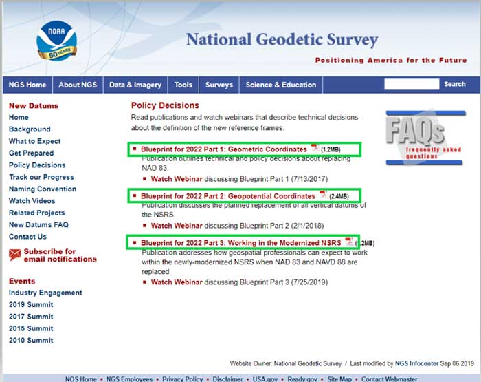
In support of the modernization of the National Spatial Reference System (NSRS), NGS has published three documents denoted as Blueprints for 2022 that describe the modernization of the NSRS (see the box titled “NSRS Modernization NGS Blueprint Documents”).
There are several sections in NGS Blueprint for 2022, Part 3, “Working in the Modernized NSRS,” that discuss the process of performing leveling projects after 2022. Something that will be new after 2022 is that NGS will require users to perform GNSS occupations in order to incorporate their leveling results into the new modernized NSRS.
NGS realizes that in the immediate future GNSS will not replace geodetic leveling for determining the most accurate local orthometric height differences. NGS’ plans include preparing a new leveling manual that will explicitly explain how to work in the modernized NSRS. Some of the new surveying procedures are described in Section 2.10 of Blueprint part 3. In section 2.10, NGS states that there will be substantial changes in how they process and serve up survey data, and that there will be some new ways of executing surveys. This column will focus on sections “2.10.2 Leveling” and “2.11.5 Leveling on Passive Marks” that discuss the new procedures for executing leveling surveys in the modernized NSRS. One major change is that leveling surveys will require Global Navigation Satellite System (GNSS) occupations to ensure orthometric heights computed in leveling surveys are up-to-date and are connected to the NSRS through the NOAA CORS Network. After the modernization of the NSRS in 2022, the NOAA CORS Network will be the primary access to the NSRS. This means leveling and classical surveys will require GNSS surveys to be part of the project. NGS’ plans include creating an OPUS option for processing all types of surveys. Users will be able, within OPUS, to adjust their projects using any mix of CORS data and passive control. Saying that, these same projects, on submission, will be deconstructed at NGS and reduced to the raw observations, then adjusted solely to the NOAA CORS Network to determine Final Discrete coordinates every GPS Month. The GPS Month concept may be new to some users. Blueprint Part 3 describes the concept in section “2.11.3 GNSS on Passive Marks.” The basic concept of a GPS Month is that it is four consecutive GPS weeks, with the first week in the GPS month having a GPS week number that is a multiple of four (see box titled “Definition of a GPS Month”).
Definition of a GPS Month
GPS month: Four consecutive GPS weeks, with the first week in the GPS month having a GPS week number that is a multiple of 4.
In this fashion, NGS defines:
GPS month 0 = GPS weeks 0, 1, 2, and 3 (1/6/1980 through 2/2/1980)
GPS month 1 = GPS weeks 4, 5, 6, and 7 (2/3/1980 through 3/1/1980)
GPS month 2 = GPS weeks 8, 9, 10, and 11 (3/2/1980 through 3/29/1980)
…
GPS month 513 = GPS weeks 2052, 2053, 2054, and 2055 (5/5/2019 through 6/1/2019)
etc.
So, what does this really mean to the user when performing a leveling project in 2022? For a leveling project to be processed using NGS software and/or submitted to NGS for inclusion into the NSRS database, the user must follow specific rules.
The following is from Blueprint, Part 3, section “2.10.2 Leveling:”
“As GNSS occupations are required for geodetic leveling, the rules for how many and how frequently will be:
For a leveling project to be processed using NGS software and/or submitted to NGS for inclusion into the NSRS database, its field observations should not span more than one year. Longer projects should be broken into sub-projects of less than one year.
A minimum of three “primary control marks” must be in the level network for every project.
More primary control marks should be added so there is never more than a 30-kilometer linear distance between marks in the entire network.
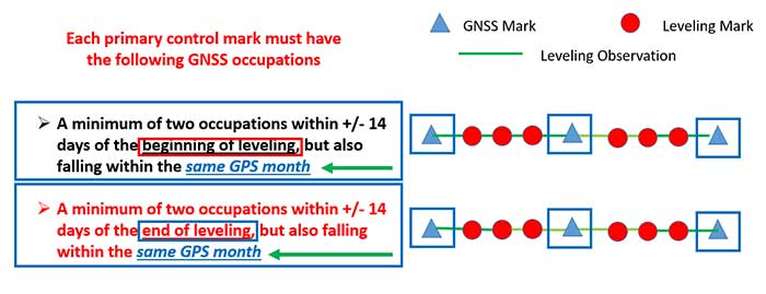
Each primary control mark must have the following GNSS occupations (details on using GNSS occupations to work in the NSRS will be found in the update to NGS 58):
A minimum of two occupations within +/- 14 days of the beginning of leveling, but also falling within the same GPS month and whose local start times are separated by between 3 and 21 hours.
It is preferable, but not required, that all occupations on any primary control mark occur within the same GPS month as those of all other primary control marks.
A minimum of two occupations within +/- 14 days of the end of leveling, but also falling within the same GPS month and whose local start times are separated by between 3 and 21 hours.
It is preferable, but not required, that all occupations on any primary control mark occur within the same GPS month as those of all other primary control marks.
All projects exceeding six months must have a third set of GNSS occupations on all primary control marks some time near the middle of the project, without a rigorous rule as to when. They must follow the “minimum of two occupations” rule as per above, and each mark’s occupation is required to fall in the same GPS month, with a preference that all primary control marks are occupied in the same GPS month.”
The box titled “GNSS Procedures for Leveling Projects” highlights the GNSS rules that need to be adhered to when performing leveling projects in 2022.
GNSS procedures for leveling projects
For the Immediate Years Following 2022, NGS Will Require That all Leveling Projects Turned in Have GNSS on Primary Control
Minimum of 3 Points with a Maximum Spacing of 30 km
At Least Two Occupations of Each GNSS Primary Control:
+/- 14 days of Beginning of Leveling
Within the Same GPS Month
+/- 14 days of Ending of Leveling
Within the Same GPS Month
Diagram: David B. Zilkoski
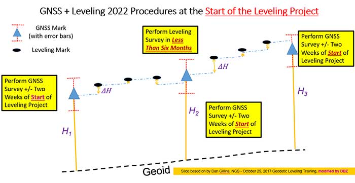
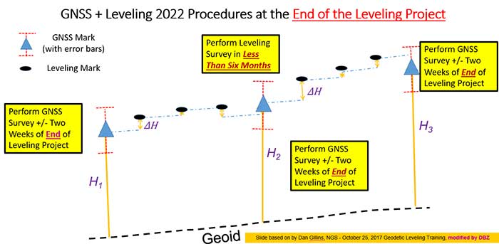
The boxes titled “GNSS + Leveling 2022 Procedures at the Start of the Leveling Project” and “GNSS + Leveling 2022 Procedures at the End of the Leveling Project” provide conceptual diagrams that illustrate what this means to a typical leveling project.
Diagram based on information from Dan Gillins, NGS, and modified by David B. ZilkoskiDiagram based on information from Dan Gillins, NGS, and modified by David B. Zilkoski
So, why is NGS requiring users to perform GNSS observations in support of leveling project. Leveling is a differential measurement technique; it generates relative height differences not absolute heights. In NGS’ modernized, time-dependent 2022 NSRS, the absolute height will be provided by up-to-date GNSS data; and the accurate relative height differences between leveling marks will be provided by the leveling data. (See box titled “Why NGS Requires GNSS Occupations on Primary Marks.”)
Why NGS requires GNSS occupations on primary marks
The Connection to NAPGD2022 is Obtained Through GNSS and a High-Accuracy Geoid Model
Network Accuracy
The Accuracy of the Height Differences are Provided Through the Leveling Data
Local Accuracy
Combining the leveling and GNSS increases the redundancy in a survey network
NGS is developing models and tools to facilitate the incorporation of leveling survey data and adjustment results into the new modernized NSRS in 2022. Blueprint, Part 3, section “2.13.3 OPUS for Leveling,” describes NGS plans to support leveling surveys through the use of the OPUS web tool. The box titled “OPUS for Leveling” outlines how NGS will modify the OPUS web tool to support leveling surveys.
OPUS for leveling
Support for leveling surveys will follow many of the best aspects of OPUS
Uploading and processing digital data files
Using a web-based graphical interface
Submitting data to NGS
Leveling is a differential measurement technique
It generates relative height differences not absolute heights
For users who need absolute heights in the NSRS
OPUS will support a mix of GNSS and leveling in a single project
NOTE: NGS will require a GNSS survey to be performed at specific times before and after leveling surveys in order for the data to be submitted for inclusion in the modernized NSRS after 2022.
NOTE: Leveling surveys longer than one year must be broken up into multiple projects. Leveling surveys between 6 and 12 months in duration require a third, intermediary GNSS data collection.
This column highlighted that in the modernized NSRS the only way to get “into the datum” will be through a GNSS survey. It noted that leveling projects generate relative height differences not absolute heights. In NGS’ new modernized, time-dependent NSRS, the absolute height will be provided by up-to-date GNSS data; and the relative height differences between leveling marks will be provided by the leveling data. A major requirement will be that users must collect GNSS data both at the beginning and at the end of a leveling survey project. Leveling survey projects that take longer than one year to complete must be broken up into multiple projects. NGS is developing model and tools to facilitate incorporating all types of survey data into the new NSRS. I would encourage all readers to read NGS’ Blueprint for 2022 documents to obtain a better understanding of the new, modernized NSRS.
Spectrum regulation is much like land-use zoning: certain services are kept separate to avoid disturbing the neighbors. The U.S. Federal Communications Commission (FCC) has in effect allowed Ligado to build an outdoor concert venue next to a monastery, and by way of compensation, they offer free earplugs.
GPS/GNSS signals are extremely weak and the receivers are extremely sensitive. To give some perspective, by the time they get to the GPS receiver, GPS signals are about a factor of 20 less powerful than cosmic background noise. Ligado’s spectrum was licensed for mobile satellite services (MSS) and so was not likely to interfere with GPS.
“The U.S. Federal Communications Commission (FCC) has in effect allowed Ligado to build an outdoor concert venue next to a monastery, and by way of compensation, they offer free earplugs.”
With its new, and much more valuable license, Ligado now has a legal right to build a terrestrial cellular service. Exhaustive testing over the past 10 years has repeatedly demonstrated that such a system will interfere with high-precision GPS/GNSS receivers used in surveying, timing and Earth observation. The Department of Defense (DOD) has also made strong claims that such a system will cause harm to its systems. In all cases, the effect is much like riding a bicycle at night. You can see fine until someone comes around the corner with the high beams on and blinds you.
In its earlier filings, Ligado had asked for permission to transmit at a power level of 1500 Watts. In an amazing piece of legerdemain, they convinced the FCC, but not the Department of Transportation (DOT) or DOD, that by reducing transmit powers to 10 Watts, there would be no harm. This is a stunningly erroneous claim. As you lower the transmit power, you need many more cellular base stations to cover a given area. To use an analogy from my backyard, I can install one high-flow sprinkler head to cover the entire yard or a bunch of low-flow heads, each covering a small portion. Either way, the grass doesn’t care about anything other than inches of water, and I’m going to get wet if I run across the yard. Ligado’s core argument is equally wet. Nonetheless, it has great appeal to people who don’t understand how cellular systems work.
So, moving forward and assuming the license stands, interference events will become more prevalent and GPS will be deemed “less reliable.” Because interference sources are largely untraceable, blame will rarely attach to Ligado. I expect that GNSS receiver vendors will incorporate improved filters into receivers and pass the cost along to buyers. Ligado, or more likely whoever it sells the spectrum to, will quickly move to petition for increased transmit powers to lower capital costs; after all, more base stations cost more. And so, the Visigoths have arrived, 4G in hand with a 5G label.
Logan Scott is founder and owner of Logan Scott Consulting, www.gpsexpert.net.
A Loyal Wingman drone rolls out, the U.S. Air Force (USAF) sponsors air taxi-cargo UAS development, and medical deliveries take place in Scotland and Florida — we have quite a wide selection for this month’s news.
Fighter support drone
Boeing Loyal Wingman prototype (Photo: Boeing)
Boeing Australia has just rolled out the first “Loyal Wingman” for the RAAF (Royal Australian Air Force) — in essence what looks like a completed first article of three prototypes on order for Australia’s Loyal Wingman Advanced Development Program.
The concept is to develop an “inexpensive, expendable” UAV which will fight alongside today’s frontline fighter aircraft, controlled from the ground or from the air. A “force-multiplier” which doesn’t risk either pilot or the heap-expensive interceptor/ground attack aircraft themselves, a real bonus for smaller air-forces, and a less costly way of increasing numbers.
The first prototype will now go into a ground and flight test program to prove out systems and flight capabilities – first flight would likely be later this year.
A team of 35 Australian aerospace companies are supporting the Loyal Wingman project, including BAE Systems Australia which has been selected to supply the flight vehicle management system, flight control computers and navigation equipment.
Flying cars?
The U.S. Air Force wants a fleet of them by 2023!
So in a novel way to stir interest in the concept of flying cars, or perhaps cargo carrying drones, the Air Force launched a program known as “Agility Prime.” The program may have begun conventionally with seed contract(s) to drone manufacturers, but their latest “webcast” approach provided an extensive overview of what this could mean to the U.S. industry.
From April 27 through May 1, a panel including Air Force leaders, two U.S. Senators, NASA and Federal Aviation Administration management, and key Air Force and Defense Department players participated in an open presentation to industry, investment and State Government participants — all with the aim of accelerating civilian development of “advanced air mobility vehicles.”
Recognizing that a principle problem is overcoming regulatory hurdles, USAF intends to provide a route to commercial revenue service such as logistics transport and disaster recovery by perhaps providing access to its key testing capabilities and facilities. With broad participation in the program by industry, government and investors (i.e. USAF don’t intend to pay for it all) the program would satisfy an operational safety and security baseline and provide a platform for the “Race to Certification” of commercial drone product(s) the USAF might also want to buy.
One of the possible solutions for a cargo drone already funded includes the Sabrewing Cargo Drone – known currently as Rhaegal-A.
Four electric powered ducted fans rotate for Vertical Take-Off and Landing (VTOL) and are powered by a Safran (French) Ardiden 3 helicopter turbine engine – giving this large UAV a design speed of 245 mph, a ceiling of 20,000 feet and range of 1000 miles.
Sabrewing has received $3.25m under a two year USAF sponsored Small Business Incentive Research (SBIR) project in the hope that the design could be eventually adapted to military logistics applications. The vehicle is intended to be able to fly autonomously, has detect and avoid capability, and can even operate when GPS is continuously jammed — something the military would probably appreciate. Potential casualty evacuation is also of great interest.
Medical supplies delivery
Meanwhile in the U.K., in cooperation with the U.K. Civil Aviation Authority (CAA), Skyports drone company is playing in the CAA’s “Sandbox.” This is another term for an umbrella/sequence of trials under CAA safety and security constraints where innovative approaches are given a chance to demonstrate that new aviation related things are possible, that they actually work and that they meet the CAA criteria. Skyports wants to test out Beyond Visual Line of Sight (BVLOS) operations for its upcoming trial of medical deliveries between Oban and Mull off the West Coast of Scotland.
As front-line health professionals fight to beat the COVID-19 pandemic, deliveries of essential medical supplies between medical facilities can be speeded-up significantly using drones. Skyports will begin the week-long trial between Mull and Oban medical centers in the last week of May.
The planned BVLOS flights will be over a 17-mile route in unrestricted airspace and avoid the Oban airport, crossing the narrow sea channel and onto the North coast of the Isle of Mull. Skyports already has experience transporting medical and other high-value cargo in other parts of the world. The candidate drone is equipped with Iris Automation Casia detect-and-avoid computer vision system, and Thales Remote ID, and the Skyports drone team is also supported by Thales SOARIZON flight management and mission planning system.
Drones to deliver prescriptions
And finally, something quite helpful during the current coronavirus pandemic — CVS and UPS having linked up some time ago, are to begin delivering prescription medication to customers in Florida. The process has been previously checked out during November last year trials in Cary, N.C.
UPS will use the Swiss Matternet M2 delivery drone, picking up medication at specific CVS location(s) and flying it to a delivery point at “The Villages” in Central Florida, then the “last-mile” delivery is by road — presumably by an outfit which knows the layout of this huge facility where something like 130,000 retirees live. Useful during this phase of Florida’s self-quarantine for elders who may find it difficult to get out to the drug store. Hope they start running the same service out of my local CVS.
Wrap-up
So from the extreme military application of drone support for fighter attack missions, and USAF sponsored development of air-taxis and cargo drones, through to medical supply deliveries by drone in remote areas of Scotland and prescription deliveries in Florida — activity never seems to abate in this growing industry.
The world so close has never seemed so far away. Locked up and adrift, somewhere between the comfort of the past and the anxiety of the future, the present slowly passes by in a procession of nameless days. The living room has become a sundial. Shadows pass from one wall in the morning to the far side by day’s end. Outside, spring has sprung, but inside, winter lingers on.
Alone, we can do so little. Together, we can do so much. —Helen Keller
Times like these, detached and disruptive, are opportunities in disguise. Ironically, while the world is confined and socially distanced from one another, humanity is more connected than it has ever been. Hard to believe, but smart mobile devices began just over a decade ago; and we are in the midst of a growing tsunami of connected devices, cloud computing, big data and open source. These events, coinciding with the exponential growth of geographic information systems and data analytics, have set the stage for crowdsourcing and citizen science. The era of empowering individual contributors has begun.
It has probably gone unnoticed due to all the political wrangling in Washington, D.C., but over the last two administrations, with bi-partisan support, without recognition or renown, a monument to American ingenuity was christened. Beginning in 2010, the America COMPETES Reauthorization Act was passed. Then, in 2014, the White House elevated homegrown inventors and creators calling it the Maker Movement and hosted the first-ever National Maker Faire. In 2015, the STEM Education Act became law and in the same year the Senate introduced The Crowdsourcing and Citizen Science Act. In 2017, the American Innovation Competitiveness Act became law formally coining the term, crowdsourcing. In 2019, the White House Office of Science and Technology Policy (OSTP) delivered the first-ever comprehensive report to Congress about federal agencies activities involving crowdsourcing and citizen science (FedCCS). Also in 2019, OSTP along with the General Services Administration (GSA) hosted the U.S. Government Open Innovation Summit.
The OSTP FedCCS report to Congress titled, “Implementation of Federal Prize and Citizen Science Authority,” cites 169 FedCCS prize competitions conducted by 18 federal agencies, such as the National Aeronautics and Space Administration (NASA), the Centers for Disease Control (CDC), and the National Institute of Science and Technology (NIST). However, the number of FedCCS projects is much greater than what is covered in the report. On Challenge.gov the amount of competitions rose from 744 in 2016 to 875 in 2018, and the prize awards ranged from $0 to $20 million with an average payout of $75,000 in FY2018. The next report is due in 2021.
Governments tapping into the resources of its citizens for innovation is not new, but it has never been on this scale and granted such authority. One of the first official attempts was the United Kingdom’s Longitude Prize in 1719 offering a King’s ransom of £20,000 [see article: From the Pyramids to GIS/GPS] to solve positioning at sea. Great Britain still honors the original Longitude Prize using the name for their national grand crowdsource competition. Similarly, in the United States the grand challenge is the X-Prize, the most famous one being the Ansari X prize. You may not know the prize by its name, but as NASA’s Space Shuttle Program phased down, the Ansari X-Prize kicked-off the space race among private companies. Scaled Composites won the $10 million prize in 2004 reaching space in a reusable craft, which became Virgin Galactic.
The term “crowdsourcing” means a method to obtain needed services, ideas, or content by soliciting voluntary contributions from a group of individuals or organizations, especially from an online community. —15 USC Chapter 63 §3724 (2): Crowdsourcing and Citizen Science
The U.S. Federal Government already relies on the public for information to help improve and maintain its products and better serve the country. The National Oceanic & Atmospheric Administration (NOAA) has had an ongoing cooperative with the U.S. Power Squadrons since 1963 to report safety hazards to navigation and help maintain the information on maritime nautical charts. The agreement to support NOAA was renewed in 2013 for another 50 years.
Image: U.S. Geological Survey
The Federal Aviation Administration (FAA) accepts reports from the general public, especially aircraft pilots regarding the accuracy of information in the products it publishes which can affect changes to aeronautical charts and flight operations.
The U.S. Geological Survey (USGS) has The National Map Corps (TNMCorps), which began in 1994 with the Earth Science Corps and the Adopt-a-Quad program. These two programs consolidated into a single online crowdsourcing effort to support USGS in 2013. TNM Corps helps maintain USGS’s maps and allows private citizens to do feature collection activities. It is easy to join and simple to use making it a way for all ages to join the crowdsource movement. What is also significant about USGS is that Dr. Sophia Liu, Co-Chair of the Federal Community of Practice for Crowdsourcing and Citizen Science resides there. Dr. Liu helped stand-up FEMA’s crowdsourcing and citizen science unit in 2007. She is now the coordinator of FedCCS activities and helped co-write the 2019 OSTP FedCCS report to Congress.
Crowdsourcing is about actively engaging people in a certain task, sometimes a very specific micro-task that includes a two-way feedback loop with the public. We need to leverage the human power that is better at understanding, processing, and communicating information.
—Dr. Sophia B Liu, Innovation Specialist, USGS
Some of the most popular sites for GIS enthusiasts to get involved are Open Street Maps (OSM), GISCorps, GeoHIVE and Zooniverse. OSM has more than 2 million contributors worldwide and has been on the front line of international disasters beginning with the 2010 Haiti Earthquake. Through its Humanitarian OpenStreetMap Team (HOT) it has supported operations of the Red Cross, FEMA, and United Nations. Through the power of the crowd, OSM contributors rapidly map transportation networks in disaster areas to show the most accessible routes in order for rescue operations and emergency supplies to reach the most impacted communities.
The GIS Corps, founded in 2003, operates under URISA and coordinates short-term mapping volunteer projects for humanitarian relief, human rights, disaster response, and other important efforts. Over 4,500 volunteers have helped support 195 missions around the world such as Hurricane Katrina, Ebola outbreaks in Sierra Leone, and the Nepal earthquake, in fact, if there is a crisis somewhere in the world, GISCorps is most likely going to have an effort in place to support it.
GeoHIVE (Geospatial Human Imagery Verification Effort) is an imagery based geospatial crowdsource platform which began in 2015 eventually replacing Tomnod in 2018. Digital Globe formed a collaboration with Radiant Solutions, SSL and MDA combining efforts and resources creating a more robust crowdsourcing platform. GeoHIVE’s 3,000 volunteers have contributed to nearly 700 campaigns. Registering for GeoHIVE requires an Amazon Mechanical Turk account, which allows contributors to be compensated for crowdsource tasks.
Zooniverse began as an astronomy site to enable hobbyists to help classify galaxy types but quickly grew into a crowdsource platform that encompasses all sorts of projects in addition to its cosmic origins including art, biology, literature and there are several spatially related projects to be found, as well. With Zooniverse you can contribute to science by studying gravitational waves or categorizing auroras as the ionized plasma washes up onto our cosmic shore.
90% of all the scientists who have ever lived are alive today. —Steven N. Rader, Deputy Manager, NASA, Center of Excellence
That quote by Steven Rader of NASA is accredited to Derek de Solla Price in 1961 referring to the exponential growth in the number of PhD’s and patents throughout the world. But now, science is in the hands of the Makers — those with 3D printers or those who can program a virtual world, or design an augmented reality, or those who can extract patterns from data and provide meaningful intelligence in geography, demographics, genetics, biology, and every field of study.
Citizen scientists are making a significant mark upon the world. Take for example CeCe Moore, a genealogy hobbyist who became a self-taught expert and now tracks down killers solving several cases using her laptop and open source DNA records. Gary Hug, a backyard astronomer, who built his own observatory in Topeka, Kansas, has discovered over 300 asteroids in near Earth orbits, and in March, Michael Mattiazzo, a citizen scientist astronomy enthusiast, discovered comet (C/2020 F8) SWAN which will make its closest approach to Earth on May 13th inside Earth’s orbit. Then there is Ted Ground, a citizen scientist hero. Ted is a winner in multiple citizen science competitions winning the NASA ideation challenge for the Mars ballast payload, the Bureau of Land Reclamation challenge for identifying insect invertebrates in rivers and estuaries, and the INNOcentive challenge for identifying trace minerals in livestock.
The day before something is truly a breakthrough, it’s a crazy idea.
—Peter Diamandis, executive chairman of the X Prize Foundation
Challenges are competitions sponsored by governments, private industry, non-profits and international entities. At the end of this article are listed several challenge sites. Agencies of the U.S. government post their challenges on Challenge.gov and CitizenScience.gov. Challenges are opportunities to work on projects for NASA, DOD, EPA, NOAA, FEMA, USGS, DARPA, and a growing list of agencies and companies. Most of these projects can be worked on at home with a laptop. Some challenges are for money or other prizes and some are just for the recognition, but all of them are ways to improve skills, build connections, and enhance a resume.
In closing, the legislation signed into law since 2010 culminating in the America Innovation and Competitiveness Act of 2017 requiring bi-annual reports to Congress directs federal agencies to use Crowdsourcing and Citizen Science. This movement empowers the individual. There has never been a better time for an idea whose time has come.
All achievements, all earned riches, have their beginning in an idea. —Napoleon Hill, Author of Think and Grow Rich
A final note: The four-part television series, “The Crowd & the Cloud,” sponsored by the National Science Foundation (NSF) and hosted by Waleed Abdalati, former NASA chief scientist, can be seen here.
Open space: the final frontier. These are the voyages of the professional surveyor and their crew. Their mission: to explore and survey strange new lands. To retrace old boundaries and to create new parcels and subdivisions. To boldly go where no one has gone before (unless it has been previously surveyed and platted…)!
With a nod to Star Trek fans (and apologies to Mr. Roddenberry), the surveyor has been the terrestrial version of the Captain Kirk and Science Officer Spock, exploring existing and uncharted territories. While most surveys completed in the modern day are retracements of previous parcels, there are still areas where surveyors are completing various tasks where no one has been before.
There are very few instances where a survey is performed near others. By this simple fact, one can argue that the surveyor is the original social distancer. The real question, however, lies within the determination of the value of the surveyor and if the work we perform is an “essential service.”
This article is not attempting to debate the value of the surveyor versus all the first responders, doctors, nurses, healthcare personnel and the hardworking employees doing their best to keep up with our basic needs. We are here to discuss the challenges faced by the surveyor and how technology has provided much-needed tools for crossing this abyss of doom and despair called COVID-19.
But first, let us talk about how we arrived at this extraordinary time for nearly everyone on the planet.
Photo: LeoPatrizi/E+/Getty Images
Worldwide upheaval or some close facsimile thereof
Every generation has a historical event, moment or era for which they remember exactly what they were doing:
“Greatest” generation (born before 1924): the Stock Market crash of 1929 and subsequent depression
“Silent” generation (born 1925-1945): Pearl Harbor and World War II
Baby Boomers (born 1946-1964): Korean War, the Kennedy assassination, the Moon landing and the Vietnam War
Generation X (born 1965-1980): Reagan assassination attempt, Challenger explosion, death of Princess Diana
Millennials (born 1981-1996): 9/11, Aurora and Sandy Hook shootings
Unfortunately, the series of events leading up to the nationwide shutdown because of the COVID-19 pandemic will unseat most of those events and eras. While previous pandemics (for instance, the Spanish flu of 1918) struck and killed many more people, the mobility of today’s population coupled with instantaneous media coverage provides a much different environment for this situation.
Image: CDC.gov
Obviously, we are not alone, and this virus has spared few countries and races. Different cultures across the globe have adapted for the pandemic in a variety of ways, and the U.S. has faced the same challenges across our diverse environments.
Depending on where one is located, they face a different set of challenges due to the pandemic. Several heavily populated urban areas are subject to a strict lockdown while states with mostly rural areas are less restrictive. One size does not fit all when dealing with limiting public exposure to others, but let us leave the debate of how much restriction is needed to the scientists and public officials. Many today do not agree with the rules we have been dealt with in going about with our lives. That is a discussion for another time and different forum.
Instead, let us discuss what we face going forward with our “new reality” of some form of social distancing and how the need for surveying and geospatial information remains for a large portion of this world. We must simply adapt to this situation with the adoption of new technologies and a revamped workflow.
Everything changes, whether we like it or not
The surveying profession is not unlike many other service-oriented and public-serving occupations, even with most of the field work being performed in solitude. We still deal with clients, governmental agencies, other consultants and the public.
The COVID-19 pandemic has changed the way we are now interacting with those outside partners with technological advances and modified communication conduits. Many of these methods existed well before this situation, but the rapid advancement of the pandemic forced many companies and employees into adapting very quickly.
Surveyors are no different, so let us run through the changes we have seen within the industry.
Project communication
The biggest challenge facing most surveyors in dealing with the pandemic atmosphere has been communication. Whether it is with employees, clients, government agencies or other consultants, communication has been affected mostly because of the elimination of face-to-face opportunities.
Technology to allow remote communication has existed for many years, but not many of us have taken advantage of it because of the convenience of in-person interaction. Who does not want to leave the office to meet with a client, shake their hand and close the deal? Or have the client come to your office and go over the intricacies of a complex survey?
Regardless of whether one is introverted or extroverted, human contact has always helped establish and solidify relationships. For most of us, this is how business has always been done, be it your client or your employees.
Obviously, the biggest area affected has been daily interaction with employees. Controlling workflow, handling projects and troubleshooting any situation is more difficult when the team is not physically in the same location. If a team member is overwhelmed, another one can immediate meet with them and help. Work is easily passed between teammates with little effort.
But working remotely? That takes more effort, consideration and technology to accomplish. Yes, video conferencing has been in place for many years, but mostly in large companies and only implemented it in a dedicated conference room. Not many employees were previously afforded a webcam, microphone and speakers along with the necessary software; all of these components are now standard issue. For many, programs like Zoom, Skype and Microsoft Teams are now a critical communication tool for timely and efficient sharing of information.
What about communication with field crews? Many would say that even a pandemic would not change how we stay in touch with field crews, but even these relationships have been affected. While there are survey companies operating with limited physical contact as a norm (large firms with projects regionally or nationwide), most surveyors still have a substantial amount of direct communication between field and office. This situation has forced many firms to take precautions, with crew members only handling specific pieces of equipment or performing a thorough cleaning if sharing during a project.
Project documents and files have typically been been handled manually with some electronic data files being transferred via email or internet. Depending on the size of the original document, having a full-size paper copy of a previous survey or subdivision plat has advantages to looking at a PDF image on a tablet or computer screen while in the field. Many companies outfit their field crews with 11 x 17-inch printers to be able to print larger detailed areas of bigger documents. Additional care must be taken if these items will still be used for field operations.
Image: Tim Burch
The transfer of data between office and field has become faster, more efficient and safer with technology. As data collectors have become more capable, direct connections via the internet to cloud storage is making transfer of project files and photos faster and more secure by providing immediate backup to guard against data loss. What used to take a trip to the office, connecting to a computer and downloading is now done in a matter of minutes without leaving the job site.
Field personnel are also benefiting from technology within our devices. Apps like FaceTime and programs like Microsoft Teams provide a gateway to video chatting so teammates can discuss projects in real time. Shared pictures, computer screens and face-to-face interaction provides an avenue to more effective communication and enhancing relationships between team members.
The pandemic has forced many surveyors to adapt and learn several new apps and programs to connect in new ways; however, this pandemic has also affected how we go about our field operations, too.
Enhanced data collection
Not many of the surveyor’s field activities are affected because of social distancing requirements, but the pandemic has forced our profession to be compliant with the new rules in case we are in proximity with others. Newer technology, using both terrestrial and aerial platforms, are now being utilized by more surveyors for their data collection needs.
Train employees now. As many companies have seen a slowdown in work due to pullbacks from projects moving forward, now is the time to get employees trained with the new technology and software to be better prepared for when the market comes back.
Using photogrammetry tools. Photogrammetry, lidar and laser-scanning systems are being purchased and implemented for everyday use and not just “special” projects with larger budgets. Not only are surveyors finding it keeps them further away from other people, it also allows for more efficient data collection and representation of existing conditions.
Flying unmanned aerial vehicles. UAVs continue to grow in popularity, and like the other technology discussed above, many firms are investing in becoming remote pilots and implementing aerial photography and lidar into their workflow. Previously, most surveyors (and the general public) would use Google Earth, Bing and other resources for aerial imagery to gain a better perspective on their project sites. Vendors are coming out with aerial products with more recent flights at a higher resolution, but do not offer the ability to extract reliable topographic data easily. In-house UAVs provide more flexibility and control over the information needed, and many are using their downtime to become familiar with aerial products.
Photo: GPS World
Dipping toes into remote sensing. Another sector of surveying equipment seeing increased use during this situation are new total stations with remote-sensing capability. Many surveyors may not have the need for a standalone laser or lidar scanner, so several manufacturers have introduced a total station that provides limited remote sensing for everyday use. While the built-in scanner is not nearly as robust as a traditional remote-sensing unit, it provides enough capability and accuracy for most users. This intermediate step of remote sensing helps a firm decide how much scanning they will produce and if an investment in a full function unit is right for them.
Upgrading GNSS receivers. We would be amiss if we did not mention that more surveyors are now upgrading their GNSS receivers to take advantage of more constellations, integration with IMUs and increased computing power of the latest data collectors. Some surveyors who are not as economically affected during this pandemic are taking advantage of great deals on new equipment and using this time to increase their capability and efficiency. As more satellite vehicles become available, the ability to gain accurate and precise locations is better than ever, so staying ahead of technology is still important in these times. We will continue to see more gains with L5 and L1C signals from the new GPS Block III satellites within the next few years, so staying current now is very important.
QA/QC — The electronic method
One trouble spot seen within the new paradigm is the ability to provide a thorough quality assurance/quality control (QA/QC) process on all surveying operations. Without the ability to print/plot original surveys at full scale, it becomes a more difficult procedure to review and analyze information on a computer screen.
The monitors used for drafting and calculations are getting bigger, but studies have shown the human eye will focus differently on an electronic screen compared to a survey on paper. There must be many other professions and occupations using similar technology who have yet to solve the QA/QC dilemma. Hopefully, our industry will find a way to help address this issue and provide guidance.
Image: Tim Burch
More connected than ever, yet still so alone
The COVID-19 pandemic of 2020 (let us hope that is all it encumbers) will be forever etched in our memories as frightening and unbelievable. More than 100 years has past since the last pandemic of this proportion has overwhelmed our population. We are much more advanced in our education of health, medicines and technology than the previous event, yet we were caught off-guard by the speed in which the virus spread throughout our lands. It taxed most of our health infrastructure beyond its limits and took its toll emotionally and financially to most of the population.
We were forced to adapt very quickly to a new norm of working remotely and independently of our co-workers and teammates. Did it hurt our productivity and profitability initially? Absolutely. Were our employees forced to learn new ways of doing their work and communicating by other means. Yes, they did. Was there a need for rapid troubleshooting of new procedures and task management? Of course. Has every transition of remote work been a success story? I doubt it, but it was not for lack of trying.
We are doing the best we can, and the surveying profession is rapidly trying to adapt. Like the rest of the world, the surveying profession will not be the same coming out of the restrictions placed upon us because of the pandemic. We have learned more about ourselves and how capable we are with tools we have. We also learned how we will transition with these skills into new technology not invented yet.
Surveyors are a tough bunch, so the social distancing and adaptation required to survive the COVID-19 pandemic of 2020 — while not easy by any stretch — has been handled with grace and professionalism. I would say to bring on the next one, but would rather this pandemic be in our rearview mirror quickly and not see anything like it ever again.
America’s space assets are in danger from an array of kinetic, non-kinetic, electronic and cyber threats. These are wielded by nation states, primarily China, Russia, Iran and North Korea, though there are other countries as well as non-state actors.
On March 30, the Center for Strategic and International Studies (CSIS) Space Threat Assessment 2020 released a catalog that highlights the ways essential space-based services Americans rely upon can be degraded or eliminated. But it doesn’t do much to “assess threats.”
That said, it is still an impressive, useful and informative document. Some of what it doesn’t say can be inferred, and it provides a clear conclusion for policy makers and others.
Threat assessments are typically undertaken to:
Identify potential dangers,
Evaluate their credibility,
Weigh potential impact, and
Estimate the probability of the threat turning into an incident
This CSIS report generally stops after accomplishing the first two tasks.
Nonetheless, it is very instructive in a several ways.
Interference with Space Systems
First, it is packed with examples of how America’s adversaries have armed themselves, and stories about interference with space-based systems. Whether it is information about China training troops to use direct-ascent weapons, or reports about Russia’s mass GPS spoofing, the report’s matrix of threat categories is well supported by examples of real-world events.
Second, while the report doesn’t overtly rank threats and adversaries, it is possible to infer some generalities by the attention the report devotes to each. Among potential adversaries, China was mentioned the most by far — 429 times. It was followed by Russia (275), Iran (206), India (141), and North Korea (132).
This word cloud from CSIS Space Threat Assessment 2020 shows that China received by far the most mentions, followed by Russia. (Image: RNT Foundation)
Jamming and spoofing
Jamming and spoofing seem to be the most credible threats and were mentioned 188 times, with ASAT and direct-ascent closely following with 179 mentions. This particular word count might not be reflective, though, as the report contains many more examples of real-world jamming and spoofing than ASAT and direct-ascent.
And of all the types of satellites that could be threatened, GPS/GNSS was the clear leader at 98 mentions, with communications and surveillance coming in at 42 and three, respectively.
In all fairness, at only 80 pages, it’s not possible for Space Threat Assessment 2020 to be an exhaustive analysis. And doing more would likely require making it classified. Then this exceptionally educational reference would not be nearly as available for the policy making audience that sorely needs it.
And it does provide an excellent bottom line for those making macro-level decisions about space policy and budgets going forward. From the report’s “What to Watch” section:
Electronic counterspace weapons continue to proliferate at a rapid pace in both how they are used and who is using them. Satellite jamming and spoofing devices are becoming part of the every-day arsenal for countries that want to operate in the gray zone — i.e., below the threshold of overt conflict. The jamming and spoofing of satellites has become somewhat common, and without strong repercussions these adverse activities could gradually become normalized…
One should expect that the rate of satellite jamming and spoofing incidents will only increase as these capabilities continue to proliferate and become more sophisticated in the coming years.