Leaders in the GNSS/PNT community are reacting to the Federal Communications Commission (FCC) decision to approve an order to allow Ligado Networks to deploy a low-power nationwide 5G network. The departments of Defense and Transportation have criticized the decision, concerned about interference with GPS signals.
Below are statements we have received from our readers.
Logan Scott, LS Consulting
Logan Scott
Spectrum regulation is much like land use zoning in that certain services are kept separate so as to avoid disturbing the neighbors. The FCC has in effect allowed Ligado to build an outdoor concert venue next to a monastery and by way of compensation, they offer free earplugs. GPS / GNSS signals are extremely weak and the receivers are extremely sensitive. To give some perspective, by the time they get to the GPS receiver, GPS signals are about a factor of 20 less powerful than cosmic background noise. Ligado’s spectrum is/was licensed for mobile satellite services (MSS) and so was not likely to interfere with GPS.
With their new, and much more valuable license, Ligado now has a legal right to build a terrestrial cellular service. Exhaustive testing over the last 10 years has repeatedly demonstrated that such a system will interfere with high precision GPS/GNSS receivers used in surveying, timing, and earth observation. The DoD has also made strong claims that such a system will cause harm to their systems. In all cases, the effect is much like riding a bicycle at night. You can see fine until someone comes around the corner with the high beams on and blinds you.
The FCC has in effect allowed Ligado to build an outdoor concert venue next to a monastery and by way of compensation, they offer free earplugs.
In their earlier filings, Ligado had asked for permission to transmit at a power level of 1500 Watts. In an amazing piece of legerdemain, they convinced the FCC, but not the DoT or DoD, that by reducing transmit powers to 10 Watts, there would be no harm. This is a stunningly erroneous claim. As you lower the transmit power, you need many more cellular basestations to cover a given area. To use an analogy from my backyard, I can install one high flow sprinkler head to cover the entire yard or a bunch of low flow heads, each covering a small portion. Either way, the grass doesn’t care about anything other than inches of water and I’m gonna get wet if I run across the yard. Ligado’s core argument is equally wet. Nonetheless, it has great appeal to people who don’t understand how cellular systems work.
So, moving forward and assuming the license stands, interference events will become more prevalent and GPS will be deemed “less reliable”. Because interference sources are largely untraceable, blame will rarely attach to Ligado. I expect that GNSS receiver vendors will incorporate improved filters into receivers and pass the cost along to buyers. Ligado, or more likely whoever they sell the spectrum to, will quickly move to petition for increase transmit powers so as to lower capital costs; after all more basestations cost more. And so, the Visogoths have arrived, 4G in hand with a 5G label.
John Fischer, Orolia
John Fisher. (Photo: Orolia)
At Orolia, we support the position of the DOT, DHS and DOD and the measures they are taking to protect the GNSS band. However, interference is a fact of life in this band as the GNSS signals are very weak, so additional measures must be taken for resiliency, especially for critical infrastructure. Adversarial interference is much worse than this, so a range of solutions are possible: from the simple – for example, a horizon blocking antenna that shields energy from a nearby tower – to full multi-layer defenses that include RF filtering, advanced DSP filtering/detection, alternative PNT from STL signals, atomic clock and IMU backup, and CRPA antennas. No one solution covers every case, but the problem can be managed.
Mitch Narins, Strategic Synergies
Mitch Narins
It is quite concerning when a panel of lawyers makes a decision, despite the results of years and years of studies, and over the objections of our nation’s technical and operational Position, Navigation and Timing (PNT) experts. While I have championed the need for a complementary and resilient PNT system for many, many years, one cannot dispute the worldwide benefits that GPS and other GNSS have brought — from safety, security, and economic perspectives.
As noted in the FCC’s press release, “The order also requires Ligado to protect adjacent band incumbents by reporting its base station locations and technical operating parameters to potentially affected government and industry stakeholders prior to commencing operations, continuously monitoring the transmit power of its base station sites, and complying with procedures and actions for responding to credible reports of interference, including rapid shutdown of operations where warranted.” I believe that it is imperative that GPS users, both within the Government and in the private sector, understand:
How base station location information will be disseminated, what power levels and radiation patterns will be utilized, and what recourse GPS users will have to object to the proposed location and service;
How the service will be monitored for each base station location, what systems will be used to do the monitoring, and how the monitoring information will be publicly disseminated;
How reports of interference will be filed, how and by whom they will be determined to be “credible”, how and in what timeframe will a “rapid shutdown of operations” be accomplished, and how appropriate mitigations will be identified and implemented; and
Given the importance and concern associated with this action, what special oversight mechanisms, involving civilian and military participants, should be put in place to avert potential safety, security, and economic impacts to our nation’s critical infrastructure.
While one can model, and even test problems based on the location of facilities where aircraft would be expected to be operating close to the ground (e.g., airports and heliports), one can never be sure where a medevac or other first responder helicopter may have to set down in response to an accident or incident site. In keeping with the FCC’s own press release, it is unclear how a pilot experiencing problems with GPS (if, in fact the pilot could recognize such a problem) would be able to report the issue and have it mitigated in real time to support a safety or security mission — unless all areas around all ground transmitters were mapped and first responders could request specific ones to be turned off when operations were expected in a known area. Unfortunately, the limits of these operating areas are, many times, unknown or rapidly changing (e.g., forest fires) and any delay in reaction to unforeseen events could prove detrimental to safety, security, and economic wellbeing.
Mitre conducted a test wherein small Unmanned Aerial Systems (sUAS) could detect and avoid an aircraft based on receipt of its ADS-B squits. Perhaps these ground transmitters should include ADS-B receivers and automatically go off-air if a helicopter comes within a certain distance. I have no doubt that Ligado would not appreciate this solution …
I would hope that those who disagree with this decision will seek out a means to correct this through either the legislative or judicial branches or both. Personally, I cannot see how this either “promotes the general welfare” or “provides for the common defense” (I didn’t have to go to law school to come to those conclusions). I also believe that (1) the ever growing importance and criticality of PNT services should provoke the Congress to modify the makeup of the FCC to include PNT expertise at the very top; and (2) the FCC Office of Chief Engineer needs to become an independent point of expertise akin to the Office of Inspector General to preclude undue pressure and potential political “bending” of technical analyses.
Finally, regardless of whether one agrees or disagrees with the FCC’s order, no one can possibly believe that this decade-long tale of woe is an example of governmental “best practice.” As it took the energy and significant resources from so many more important PNT initiatives, I hope that a quality/leadership body (perhaps GAO and/or a group of IGs) take up the task to do an independent “lessons learned” assessment of this decade-long tale of woe needs to be carefully examined, as it took the energy and significant resources from so many more important PNT initiatives — we should never have to go through this ever again.
Mitch Narins is the principal consultant and owner of Strategic Synergies, LLC, a technical and management consulting firm that he formed after retiring following over four decades of U.S. government service with the FCC, US Navy/Marine Corps, and the Federal Aviation Administration.
Alison Brown
Allison Brown
GPS user equipment needs to be designed to be more resilient to interference. The threat to GPS has been well understood for many years but agencies and vendors have been slow to respond to improve national resiliency against jamming threats. The President signed into law the National GPS Timing Resilience and Security Act in 2018 and on 2/12/2020 signed an Executive Order on Strengthening National Resilience through Responsible Use of Positioning, Navigation, and Timing Services recognizing “the disruption or manipulation of these services has the potential to adversely affect the national and economic security of the United States.” The onus is now on vendors and agencies to develop resilient solutions that can operate in the presence of intentional and unintentional interference. These solutions would also mitigate any potential impact from the use of adjacent bands by operators such as Ligado to deploy 5G and Internet of Things services.
Ellen Hall
Ellen Hall
Overall, the GPS industry should be encouraged to do more to protect themselves from harmful interference. While it is too late for today’s receivers, the next generation needs to introduce more resilience. I agree with the House Armed Services Committee Chairman in saying, “While I strongly support development of the world’s most robust, safe and secure network, using L-band spectrum in such close proximity to critical GPS, as Ligado’s proposal requires, carries an unacceptable risk….”
The FCC said the approval order included stringent conditions aimed at ensuring that GPS would be vulnerable to harmful interference. It seems the only way to prevent harmful interference, would be to permanently fund an oversight commission to monitor Ligado’s system. I believe only Congress can appropriate funding for this effort, therefore the FCC’s decision should be a recommendation to Congress to implement. It is not enough to leave it to a five-person committee to “encourage” that “stringent conditions” are implemented. Enforcement is crucial. Critical infrastructure should be regulated to ensure that we can cope better with “noisy neighbors.”
Image: ChakisAtelier / iStock /Getty Images Plus /Getty Images
By Eric Colard
Head of Emerging Products, Frequency & Time Systems
Microchip Technology
Mobile operators are investing heavily in the deployment of LTE-Advanced and 5G networks that will transform cellular communications and connectivity.
They face big risks, though: the high-performance mobile services delivered over these networks are extremely dependent on precise time from GPS and other similar regional constellations broadly known as GNSS so they can synchronize radios, enable new applications and minimize interference.
If GPS/GNSS becomes unavailable due to jamming, spoofing, failures or other events, the resulting service disruption would have a catastrophic impact on system performance.
Just like the energy grid is extremely vulnerable to climate, heat, winds and dry vegetation that can lead to fires on a large scale as seen in California recently, 5G networks are vulnerable to disruptions in the distribution of precise time that can lead to total systems outage.
New technologies enable mobile operators to protect their networks from these threats. These technologies make use of existing deployments while creating new architectures for distributing very high-precision time over long distances. They minimize additional costs while offering the necessary performance to meet the demanding requirements of 5G.
Technology landscape
The latest LTE-Advanced and 5G mobile networks bring tremendous capacity and bandwidth gains that are being used to deliver new services to consumers, industries, cities and specific market segments. From high-bandwidth video delivery for smartphones to autonomous vehicles, smart cities and the internet of things (IoT) for smart factories, these new services all rely on the synchronization of numerous sensors, base stations and other devices.
Accomplishing this requires the delivery of very precise time over long distances. Without it, mobile operators cannot maximize deployment investments by minimizing disruptions and risk.
They also must devise plans they can leverage in case of GPS/GNSS malfunction. At the same time, they need to take advantage of optical networks and other existing infrastructure so that they don’t require expensive new investment in dark fiber.
Photo: iStock.com/NicoElNino
Meeting stringent requirements
Standards bodies have defined stringent requirements for precise time and synchronization such as Prime Reference Time Clock (PRTC), which includes 100-nanosecond (ns) PRTC Class A (PRTC-A), 40-ns PRTC Class B (PRTC-B) and 30-ns enhanced PRTC (ePRTC) performance specifications.
To meet these requirements, a high-quality source of time is an absolute must and a very resilient, efficient and performant distribution mechanism is required to transport time from the source to the various devices consuming time (for example, base stations, sensors and vehicles).
The problem with relying on GPS/GNSS for meeting these requirements is that its deployment can be expensive given the increasing densification of endpoints. There is also a technical vulnerability associated with GNSS receivers located at cell sites.
If the GNSS receiver cannot track satellites properly for whatever reason, the radio must be removed from service quickly to avoid interference issues due to the short holdover period of the oscillator technologies used in the radios. Because of these technical and financial considerations, operators are very motivated to find solutions where GNSS dependency is reduced or even eliminated at many locations.
Another set of considerations for operators includes:
the distribution of time from the source to the endpoints using the network;
the network nodes; and
the various synchronization capabilities these network nodes can support.
Typically, a precision time protocol (PTP) grandmaster is located at the beginning of the timing chain and complies with 100ns PRTC-A or 40-ns PRTC-B so it can deliver precise time to the end of the chain within +/-1.5 microseconds. The network nodes on the path typically embed a Time Boundary Clock (T-BC) capability that meets either Class A (50-ns) or Class B (25-ns).
A new type of time-distribution architecture is needed to address these requirements and considerations so operators can protect their mobile network against GNSS disruption and distribute precise time over long distances for national coverage. This architecture must also deliver the necessary performance to meet end-to-end budgets for 5G needs.
A different time-distribution architecture
There are multiple capabilities a high-precision time-distribution architecture should feature so that operators can most effectively mitigate GPS/GNSS vulnerabilities and solve other challenges in their 5G networks. The architecture should:
leverage the existing optical network (thus avoiding high cost dark fiber expenses)
use a dedicated lambda in order to transport time in the most rapid manner
protect, to the utmost level, a redundant source of time that meets the highest, 30ns ePRTC performance and uses a combination of Cesium and GNSS as the source of time
have two directions for the flow of time (East and West) so that a redundant path can be leveraged in case of any issues along the way from source to endpoint
have a chain of high-precision boundary clocks (HP BCs) that can meet the highest level of performance defined by today’s standards (T-BC Class D 5ns)
A multi-domain architecture of this type offers the redundant, sub-microsecond end-to-end timing capabilities that are required to affordably deliver the high performance, 5-nanosecond per node distribution of precise time over hundreds of miles.
An example of this type of solution is Microchip’s TimeProvider 4100, which can be configured as either an ePRTC at the source of the timing chain with PRTC-A and PRTC-B time-delivery capabilities to various end nodes, or an HP BC on the optical network path.
This type of product can also be configured for application-specific requirements, end to end, with up to nanosecond precision time-delivery capabilities over long distance.
Assuring precise timing
The success of a coming generation of high-performance mobile services will depend on how well operators address today’s critical GPS/GNSS vulnerabilities. Jamming, spoofing, failures or other events can disrupt the precise GPS/GNSS timing that 5G networks need for synchronizing radios, enabling applications and minimizing interference.
The latest high-precision time-distribution architectures mitigate these risks with minimal additional cost and give operators the performance they need to support demanding new 5G services ranging from IoT-based applications to receiving high-bandwidth video on smartphones.
Microchip has released version 2.1 for its TimeProvider 4100 timing grandmaster.
Eric Colard leads product line management for Microchip’s TimeProvider 4100 and Integrated GNSS Master solutions for the telecom, utility and other industries. Colard’s leadership includes product definition, customer interaction, outbound promotions and business development.
He has held successive technical and leadership roles at technology companies in the U.S. and Europe. He began his career as an engineer in the networking arena on X.25, frame relay and other protocols at companies including Alcatel and Cap Sesa Telecom. He later held successive product management and business development leadership roles in networking, security, and other areas at Novell, Tumbleweed, FaceTime and Vernier Networks.
As the industry rapidly progressed, Colard increasingly became involved in wireless data compression and TCP/IP optimization. In 2007 he joined Symmetricom and architected and built the SyncWorld ecosystem with partners Alcatel-Lucent, Ericsson, Nokia Siemens and Cisco. Through acquisition Symmetricom became part of Microsemi, which today is part of Microchip.
Colard holds bachelor of science and master of science degrees in computer science, both from Ecole Nationale Superieure des Telecommunications (now Telecom ParisTech) in Paris, France. He is a member of the Metro Ethernet Forum (MEF), Open Compute, Telecom Infra Project and Small Cell Forum. He has received an award for his industry contributions from the Small Cell Forum.
With the rise in public unrest from COVID-19 and increasing numbers of remote operations, the susceptibility and vulnerability of a cyber attack has never been greater.
On a regular basis, we hear intelligence experts proselytize an eventual cyber doomsday where our critical infrastructure (CI) — communications systems, information technology (IT) capabilities and financial networks — are compromised or disabled. These kinds of attacks could devastate our national and economic security and even disrupt basic day-to-day activities like turning on lights or buying groceries with a debit card. Even worse, a significant cyber event could escalate to the point of military actions between nation-states.
In 2012, Defense Secretary Leon Panetta warned about a potential “Cyber Pearl Harbor.” These threats were echoed by then head of Cyber Command, Gen. Keith Alexander, with hope the public, private and CI sectors would take notice of the broad, detrimental impacts of cyber threats.
Geoff Hella, Centauri Corp.
In kind, the Obama administration took aggressive steps to protect CI networks, and the Trump White House followed suit by enacting measures to strengthen the resilience of other technologies integral to our CI.
The latest White House Executive Order specifically addresses our reliance on position, navigation and timing (PNT) services and directs agencies to work in close coordination with the private sector to identify, secure and continue to improve the resilience of these technologies.
PNT services, such as GPS, are an extension of our IT systems, but despite this, PNT has been a relatively invisible utility and is oftentimes unknowingly utilized by most CI owners and operators. In the coming years, our reliance on PNT will only increase, making now a critical time to foster close collaboration between public and private sectors and determine which systems, networks and assets are dependent on PNT services. Identifying these dependencies will allow us to verify appropriate resilient PNT services being used, determine downstream effects of the disruption and manipulation of PNT services, and manage the associated risks to dependent systems.
The new directive is fast paced — outlined in 90-, 180- and 360-day increments — and instructs agencies to utilize existing public-private sector cybersecurity and CI information sharing relationships, such as Sector Specific Agencies (SSA), to share threat data, educate stakeholders and promote a responsible use of PNT.
What’s the rush?
So, why is this happening right now? PNT systems are crucial to American life, and successfully securing them requires a coordinated response and sooner rather than later. In fact, malicious nation-states, such as Russia, are spreading their wings into new threat vectors to inflict damage and are shifting their attention to PNT.
Because of these risks, we must do more as a country to establish safeguards around these technologies. That being said, agencies and organizations cannot expect their current workforce to become PNT security experts overnight. Rather, business owners and operators would be better served bringing in third-party experts that have been building security into PNT even prior to this directive.
These private-sector partners can map out a systematic approach to prioritize PNT security in a three-step plan:
Find. Identify PNT systems and “profile” them — establish point A.
Fix. Find and correct vulnerabilities — many can be non-material/tactics, technique and procedures (TTP) solutions.
Fortify. Develop TTPs, timelines and guidance for users to upgrade CI where needed — the path to Point B.
When PNT services were first developed, the systems could be openly used by anyone and security was not built into the original PNT architecture — similar to when the internet was created. This has made it easy for adoption into almost everyday life and revolutionized the world. Likewise, it has also made it easy for bad actors to access and compromise it, forcing the country to scramble, backtrack and implement cybersecurity best practices.
The good news is that we aren’t completely starting from scratch. The Department of Defense has been working to secure its PNT systems and will be updating its processes and practices as part of the recent White House directive.
The security community can also look to best practices in assessing risk of vital systems and model PNT security measures on existing guidelines such as Federal Information Processing Standards (FIPS) and NIST Special Publication 800 Series.
Path Forward
Per the Executive Order, lead agencies such as the Department of Transportation and the Department of Commerce will work in concert with the private sector to define “PNT profiles” and share these attributes with stakeholders. The coalition of partners will then be able to account for where and how PNT is used by CI owners and operators and will promote the responsible use of PNT services moving forward.
Beyond defining PNT profiles, the EO allocates new research and development funding for Commerce to develop an alternative to GNSS, which provides real-time PNT data to planes, trains, ships and automobiles that transport vital goods and resources — all in an effort to reduce the level of acceptable risk.
The White House also requires the public and private sectors to develop vulnerability testing and incident response plans and, simultaneously, encourage the private sector to use and develop more robust PNT services in anticipation of new Federal Acquisition Regulatory Council (FARC) contract requirements.
While these changes may seem like a fast moving and overwhelming process, there are many cases where CI owners and operators will not be required to integrate material solutions, but rather procedural training and behavioral adjustments. The information sharing processes already exist to provide improved situational awareness, coordination among the public and private sectors, increased reporting, solidified baseline risk assessments and a broader understanding of how systems rely on PNT. The challenge is facilitating widespread adoption across all stakeholders, increasing collaboration and education among and across the CI groups.
For this effort to be successful, it will require a whole-community, multi-pronged approach to operating in a new “threat top-of-mind” paradigm that is grounded on cross-sector information sharing, training and education. Both public and private sectors should also outsource expertise and leverage existing models like the DoD PNT doctrine, NIST standards and incident response capabilities.
Gregory Gerten is director of PNT Operations at Centauri, supporting the PNT enterprise through innovative use of modeling and simulation, hardware-in-the-loop and field testing, and process automation. He earned his master’s degree in electrical engineering from the University of Dayton, and has completed post-graduate courses in GPS from the Air Force Institute of Technology. He has more than 20 years of experience in system design, development and integration in the areas of communications, navigation, electronic warfare tactics and weapon systems.
Geoffrey Hella is a senior engineer for Centauri assigned to a Space Command contract through the Joint Navigation Warfare Center (JNWC). He has worked to achieve a Master of Aeronautical Science (MAS) from Embry-Riddle Aeronautical University in 1994. During his 40 years of experience, he has been a leader in product development and system design to successfully carry out a vast range of assignments in multiple engineering disciplines. His assignments include: aircrew member of the United States Air force (USAF); National Air Space (NAS) engineer for the Federal Aviation Administration (FAA); Special Nuclear testing and safeguards engineer for the Department of Energy/Sandia National Laboratories; and Supervisory Control and Data Acquisition (SCADA) engineer for both public and private Industry, electric and gas utility companies. Hella currently holds a six-sigma certification and a general radio operator license from the Federal Communication Commission (FCC) and a remote pilot operator certificate from the Federal Aviation Administration (FAA).
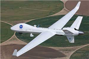
General Atomics MQ-9 Predator. (Photo: General Atomics)
There has been a lot of scene stealing by General Atomics recently with Predators flying hither and thither, new orders for the Boeing-Navy unmanned re-fueling drones and a UAV flying on Mars — this month’s unmanned aircraft summaries.
The Predator is the archetypical unmanned aircraft which most people might visualize as a “drone” as a result of numerous news reports and photos. Its what we might refer to a “Large UAV” with a 65-ft. wingspan, a 35 ft.-long fuselage and weighing in at around ~10,500 pounds fully fueled.
The SkyGuardian. (Photo: General Atomics)
In fact it’s bigger than a small manned aircraft, like the single engine Cessna 182 which checks in at 36ft wingspan/29ft fuselage. So its clear that something this big and without an on-board driver has to watch where its going, especially when flying within in the US National Airspace System (NAS).
So it was no small feat when General Atomics recently flew a new MQ-9 Predator on a delivery flight from its flight ops center in Palmdale, California, to the Holloman Air Force Base in New Mexico. There was significant coordination by the flight teams in both locations, and with the approval by the FAA. Delivering a new Predator by air saves the Air Force significant manpower, as normally new ones arrive in a crate and require effort to re-assemble.
It’s a sign of progress towards achieving approval to allow regular flights of such large UAVs in the NAS. Nowadays a Cessna 182 pilot can file a flight plan and then basically fly anywhere in unrestricted airspace. Hopefully one day — as a consequence of following rigorous certification verification and FAA approval – pilots of such Large UAS will be authorized to operate in a similar fashion.
General Atomics is working with the U.K. Royal Air Force (RAF) to develop and certify the all-weather, long-endurance SkyGuardian MQ-9B variant to meet NATO-standard Type-Certification requirements, which will then enable the UAV to be flown in civil airspace. The Australian Defence Force (ADF) has also selected this UAV variant for its unmanned applications in and around Australia. In late March, General Atomics flew the first production representative SkyGuardian – known to the RAF as the ‘Protector’ – out of its flight ops facility in El Mirage, California.
Staying with the military theme, Boeing has been working with the US Navy to develop a UAV that can land on aircraft carriers, and following a concept change by the Navy, won a contract to provide tanker UAVs. Tanker UAVs will fill up with aircraft gas on an aircraft carrier or land base, then take off and fly to rendezvous with fighter aircraft to transfer fuel and extend fighter endurance and range.
Right now tanker aircraft are usually quite large aircraft – like the Boeing KC-46A tanker which is based on the Boeing B-767 civil transport aircraft which many of you may have flown on as passengers.
The MQ-25 is still in its initial phases, with four test UAVs slated to undertake the initial flight test program. The first test vehicle has already begun exploring the UAV flight envelope and has 30 flight-test hours under its belt. The Navy has just shown confidence in the program by ordering another three aircraft, bringing the total initial build to seven vehicles.
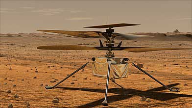
Its easy to see that UAVs are showing themselves to be extremely useful to military forces, but it might be difficult to understand how a UAV might find itself in the U.S. space program. The “Mars Helicopter” has just been mated to the underside of the next Mars Rover — now called “Perseverance” — both are slated to leave on their eight month journey to Mars in July this year.
Mars UAV being mater with Perseverance. (Photo: NASA)
With two ~4ft rotors which spin in opposite directions, the UAV will have to wait patiently for up to 90 Martian Days after Perseverance touches down in February 2021 until it gets a chance to prove that it can fly in the thin Mars atmosphere — chamber tests here on Earth in simulated Mars air have already shown that flight should be feasible.
Built to withstand high g launch and vibration forces and those of the Mars landing, the UAV carries a high resolution camera which is used for navigation, landing and survey of Mars’ surface. Its also designed to withstand the extreme temperatures and high radiation environment on the surface of Mars. The UAV is equipped with a dual-processor flight controller linked to sensors which include a gyroscope, an altimeter, visual odometer, hazard detectors and a ‘visual inertial nav system’ developed by JPL. Although the Mars Helicopter operates autonomously, it communicates with and receives control inputs from the lander, so controllers on Earth load up the flight plan ahead of time into the lander, and then wait for the helicopter UAV to execute the commands. Don’t expect vast coverage of huge panoramas of Mars – its flights are each intended to be more of an extensive hop lasting around 90 seconds at 10-15 ft above the terrain.
Mars Helicopter on simulated Mars surface. (Photo: NASA)
With a body no larger than a softball and weighing less than 4 pounds, the Mars Helicopter is an experiment to see if its possible to fly in the extremely thin Martian atmosphere. With less than 1% the density of our sea-level atmosphere, its necessary to spin the rotors at 2,800 rpm, ten times faster than on Earth. The UAV collects power from its own small solar panel and needs several days to recharge after each flight — of which five are planned. The main objective if flight is possible is to pre-survey interesting potential routes for the lander.
So preparations for large UAVs to regularly fly in civilian airspace, a new approach for Navy refueling systems, and a helicopter UAV destined to fly on Mars next year — completely different unmanned applications, all making progress.
Social distancing and stay-at-home orders are affecting every sector of our economy. How are companies in our industry rising to this enormous challenge? What are they doing to keep their staffs, customers, and communities safe and to help slow down the spread of the pandemic? What are they learning in the process?
We asked our marketing partners, Editorial Advisory Board members and “Innovation” Editor Richard Langley the questions below so that we could share their collective wisdom with you, our readers. The advertisers’ responses appear in alphabetical order by company, followed by the responses by EAB members.
We will continue to publish these responses here as we receive them; we will also publish a selection of them in the May print issue of GPS World.
Professor, Department of Geodesy and Geomatics Engineering,
University of New Brunswick, Fredericton, Canada
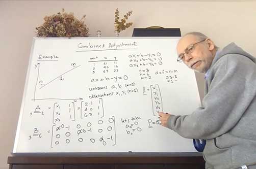
“Innovation” Editor and UNB Professor Richard Langley lectures to his students online. (Screenshot: Richard Langley/UNB)
On March 13, the president of the University of New Brunswick announced that as of the following day due to the Coronavirus-19 outbreak in the province of New Brunswick, all in-person classes would be suspended for the remained of the school term, and that starting March 23, classes would resume using alternative methods to support delivery outside the classroom. Faculty members like me had a week to find other ways to deliver our courses to the students. Some of us turned to pre-recorded video presentations and some, like me, to live class sessions using online video conferencing tools like Zoom and Microsoft Teams. I tried both but ended up using Teams on the advice of the university administration.
This term I was teaching GGE 3111: Introduction to Adjustment Calculus. Basically, it’s an introductory course on the mathematical technique of least-squares analysis. Least squares, where one seeks to find the minimum of the sum of the squares of the estimated errors in measurements, is a fundamental technique for analyzing data in many application areas in the sciences and engineering disciplines, including the processing of GNSS data. It was pioneered back in the early 1800s by Gauss, the great German mathematician and father of modern geodesy.
Incidentally, Kalman filtering also widely used for processing GNSS data, is essentially a recursive approach to the least-squares problem. The example I am doing on the board (see screenshot) is how to fit a straight line to data pairs x and y where both the x and y values contain random measurement errors. I have always taught GGE 3111 using the blackboard or, since lecturing from the dining room of my house by video link, a whiteboard.
I recorded my home-delivered lectures and provided these to the students through the Desire to Learn platform that UNB uses for teaching. Not all of the students could attend the live lectures as some had returned home to provinces with several hour time differences from New Brunswick making it inconvenient to attend a morning lecture. Others no longer had a good Internet connection to view real-time video.
The recordings also provided a useful resource to the students for reviewing the course material. When we eventually return to normality, I might continue to record my lectures. They could even form the basis of an online version of my course available to UNB students and non-students alike.
CAST Navigation has overcome many obstacles and challenges to be able to provide our customers with the products and services that are valuable to them during this difficult period. The company has instituted a set of strict policies and procedures that allow us to manage our facility hours and employee “distancing” practices.
We have also enabled employees to work remotely if necessary and we continue to work very closely with our vendor supply chain to minimize delays and impacts to our schedule. These policies and procedures, along with a very focused and devoted staff, have allowed us to continue to provide the superior quality products and services on which our customers rely.
Eos Positioning Systems’ employees are able to work remotely in most cases. In fact, prior to the pandemic, a number of full-time employees worked remotely across Canada, the United States, and the Asia/Pacific region. Now, we’ve transitioned all employees to remote working and transitioned the tasks of individuals whose routine work was directly affected by the virus. We’ve also added a weekly all-staff video Zoom meeting to address everything from company questions to individual wellbeing.
We were already grateful for our ecosystem of staff, partners, and customers, but everyone has shown their positive colors even more in response to this pandemic. Everyone remains responsive across platforms and time zones. The uptick in social media engagements of our customers and partners has been particularly great to see.
In addition, we’ve heard from some customers that they are using our GNSS receivers more during this time. Because our receivers are easy to use for the novice, office workers who would typically not do fieldwork are being trained on field work, which can be a naturally socially distanced, one-person job.
As expected, many of the events we enjoy sponsoring have been postponed or canceled. We’re working with event coordinators and our own team to ensure that when events start up again, we are prepared to go back to business as usual. We are really, truly looking forward to seeing our customers, partners, and colleagues in person again!
At GeoNumerics, we are all OK, including our families. As we are an R&D-intensive company focused on algorithms, software, and consultancy, we are lucky these days. Furthermore, some of our employees —women with young children — were already teleworking most of the time. Therefore, it was easy to extend this to the rest of the company.
Since mid-March, everyone is at his/her place teleworking. This enables us to:
keep the company running
keep our employees busy like in “normal” days
protect our customers by meeting deadlines
protect the economy by not stopping the business
on a case-by-case basis, help our providers/partners who had to stop their business.
Internally, we share a “good morning” short communication via WhatsApp and a daily 20 minute “virtual coffee break” after lunch via Skype.
Miguel Amor, Chief Marketing Officer, Autonomy & Positioning Division
Editorial Advisory Board Member
Miguel Armor
COVID-19 is affecting everyone on a global scale, which means that we all must work together to limit the spread of the virus and protect the people at risk. At Hexagon, our priority is keeping our employees and customers safe, and we are following all guidelines and recommendations set up at national, regional and local levels to do so.
Through all of this, we recognize that our employees and our customers are relying on Hexagon more than ever. Rest assured that we are taking all necessary steps to protect our employees and to minimize risk to the supply of our products and our services to our customers.
At Hexagon | NovAtel, we believe our size, reach, and position not only provide great opportunities but also carry great responsibilities. We understand that the GNSS community in general is relying on NovAtel more than ever and we are taking all the necessary steps to support the community and our customers.
Just like many of you, we at JAVAD GNSS are quickly and actively adapting to the changing times caused by the global COVID-19 pandemic. We recognize that JAVAD plays an important role in many of your operations and in supporting the critical missions of our customers. To that end, we are following best practices to curtail the spread of this virus and protect the well-being of our employees and partners, while ensuring we meet the commitments to you that you have come to expect.
Our primary message today is JAVAD GNSS is Open for Business! Our support team is here and ready to assist you as it always has. Please do not hesitate to contact us.
While there was a short pause in March when news broke in the U.S. about COVID, much of this now seems to be subsiding. At the same time, the value for instantly accessible aerial maps is more obvious than it ever was. As teams work from home and push to keep projects on track, the need for remote access to aerial photography remains strong at a time when travel and remote site inspection is lower than it ordinarily would be. Judging from very recent activity (all April 2020), there’s high interest from city government, engineering, construction, solar/energy and land development.
For Orolia, this crisis has highlighted the importance of the word “resilient.” As a leader in resilient positioning, navigation and timing (PNT) and as an essential business, we need a resilient organization that can keep delivering the critical solutions that our customers need. We can’t let our customers down because they support defense and critical infrastructure programs worldwide. Now more than ever, we recognize the essential nature of what we provide, and we must keep supporting our customers, even in times like this.
Orolia plays an essential role in the Defense Industrial Base (DIB) in the Critical Infrastructure Sector, as defined in the Department of Homeland Security (DHS) Memorandum on Identification of Essential Critical Infrastructure Workers During COVID-19 Response and the DHS Guidance on the Essential Critical Infrastructure Workforce: Ensuring Community and National Resilience in COVID-19 Response.
Many global companies need to continue operating as normally as possible to provide much needed capabilities in order to help governments, members of the armed forces and critical infrastructure to stay operational.
Our Supply Chain/Sourcing team conducts regular risk assessments to ensure that Orolia partners can continue to provide uninterrupted service by securing materials and products. Our service, support, business development. and engineering teams also remain ready to respond to requests.
We use Skype extensively, to keep in touch with our customers and partners but also for internal conference calls and meetings. There isn’t really a substitute for face-to-face meetings, but Skype is as close as you can get. In terms of communicating with our partners we have very much moved into the digital space. We have instead held webinars using WebEx which have been very well received. We have more planned so watch this space!
We have learned that we can work very well under pressure! With COVID-19 postponing some of our favorite shows we didn’t want to sit back and do nothing. We had to act very quickly and look at other ways of communicating our message. Not only have we as a business been agile enough to do this, despite working remotely, our channel partners have really taken on board what we’ve been trying to achieve and helped us exceed our goals.
Don’t use COVID-19 as an excuse to rest on your laurels. Take it as an opportunity to do some of the things that you otherwise wouldn’t have done.
To collaborate remotely, a safe distance from each other, we use video messaging (MS Teams) with team(s) daily, as well as Confluence (engineering documentation) and Jira (task management) for remote collaboration.
Much of our team is able to continue efficient operations while working remotely. Collaborating with our customers has always been a service we offer – which, we believe, leads to better product performance and reliability. This pandemic has pushed the majority of the country/world into remote working. While we aren’t able to be in person with customers, accessible remote tools and collaboration help us continue to provide hands-on customer service, without actually using our hands.
Parker LORD designs and produces MicroStrain inertial sensors that are used in robots that aid in delivery, mapping, and surveillance activities. Our inertial measurement units (IMU) and inertial navigation systems (INS) are designed to allow quick time-to-market development. We offer IMU/INS integration with our recently updated Robot Operating System (ROS) drivers for ease of use. By using our sensors, we have reduced development time while also offering top performance and competitive pricing. There are different levels of inertial sensors based on the performances available depending on the application being used.
As the need for measurement and navigation solutions increase with the demand for delivery, safety and automated robotic monitoring, our new 3DMGQ7-GNSS/INS dual antenna RTK-enabled INS provides next level performance with integrated custom IMU, dual integrated RTK-capable multi-constellation GNSS receivers, integrated barometric pressure sensor, and magnetometer. Beyond the integrated sensors the GQ7 offers hardware support for wheel odometry and API support for external velocity sensor measurements. This sensor has been designed for use in markets such as beyond visual line of sight (BVLOS) unmanned aerial vehicles (UAV), unmanned vehicle navigation, legged robots, and autonomous vehicles. It’s an all-in-one system solution (GNSS-INS + RTK + SensorCloud RTK).
Get ready for the robot revolution. There was momentum in that direction before, in areas such as delivery, recon and mapping. Acceptance of these technologies will only increase now and in the future.
Racelogic, the company behind LabSat GNSS simulators, is based in Buckingham, UK. Like many companies, we are adjusting to new ways of working and remote collaboration. With the majority of our 100 staff now working from home, I have few concerns about their ability to adapt and am confident that the outcome will be one of success. However, I am also aware that the paths taken over the coming weeks or months are unlikely to be without a few bumps in the road.
I am hearing reports from all corners of Racelogic about how staff are dealing with these unprecedented circumstances. For example, Katie Harland, our LabSat Support and Applications Technician, is continuing to support our customers from home. However, without a rooftop antenna on her building she has had to be a little inventive about how she gains a live satellite feed to record test scenarios. Her solution was to mount an antenna on a ground plate devised from the lid of a biscuit tin and set it on her garden wall. An effective solution, but one that is not straight forward when you are 5’2” and the garden wall is 7’ tall.
I am also noticing changes to what a “normal” day at work now looks like. With so many staff working remotely I find myself walking through the office and instead of checking on project progress I am rebooting computers, connecting equipment, accessing server files, and generally servicing those who are working remotely. I think it is easy to fall into the trap of obsessing about perfecting remote working. I don’t think you can go too far wrong if you focus on the things you can do, even if you need a ladder to get there.
During these challenging times, Septentrio continues to be operational and to serve its customers. We have taken measures to ensure health and safety within the company. Most of my colleagues and I are working from home, while manufacturing has been divided into two shifts to guarantee continuity and provide the safest possible working conditions. Although international travel is suspended for the moment, we continue to have regular meetings via phone or web with our partners, customers and prospective clients.
This virus is forcing us to rethink the way we work and interact. As we adjust to the new situation, we are finding ways to continue working with as little disruption as possible, leveraging the efficient communication networks and remote-control solutions available to us today. Along the way we might even discover new more efficient and environmentally friendly ways of working.
In addition to ensuring employee safety, Septentrio is also dedicated to help fight the virus by providing reliable high-accuracy positioning solutions to technologies that are making a difference. For example, aerial drones have been used by police in Europe to announce new government regulations in public places and to scope out large areas for public gatherings. To ensure public safety it is vital that the sensors aboard these aerial drones, such as their positioning receivers, are robust and reliable even in challenging conditions.
Other delivery drones such as Zipline and Wing are expected to ramp up speed with the increase of automation required to fight the coronavirus. In the European Union and the United States regulations around drone use are stricter than in China and thus the full potential of drones is not yet realized to its maximum.
Since our inception, a few of our employees have worked from home due to traffic issues, work/home responsibilities, or simply geographical location issues. Over the years, we decided as a company not only that this was working very well, but that everyone who could work from home should be allowed to have the same privileges. In the past two years, we have allowed everyone to work from home, only requiring to come into the company offices those who must be in a lab or for security reasons. Everyone has a laptop computer and remote access to files. We use Zoom, email, and cell phones to communicate with each other and our customers.
When the recommendations from the CDC and the President of the United States were issued to work from home, we were already doing this, so there were no adjustments needed. Those that must work in the lab are practicing social distancing and working on alternate days in some cases.
When we first contacted our customers to attempt visits, we were told that they were not receiving visitors and that it was going to take a few days or weeks to get everyone outfitted with laptops and other technology to continue working from home. We were a bit surprised to learn that others were going through this as we were not having any of these issues.
This crisis has taught us that being prepared and trusting our team to work independently pays off when we really need it. Everyone is being a little extra patient, kind, and understanding. We are seeing this general compassion outside of the office as well and we hope that this has a lasting effect on the world.
Jackie Ferreira, Director of Corporate Communications
Jackie Ferreira, Topcon
We are fortunate in that our team is well-versed in online collaboration software, including teleconferencing and online digital asset management systems. We are leveraging tools such as those to keep productive in this crisis.
We are working very well together via safe distancing practices. Our employees around the world are staying active with ongoing conference calls across multiple time zones. Our primary concern is the health and safety of everyone we interact with and we continue to be impressed with how all involved have responded.
Topcon operates with a primary goal of the health and safety of its employees, customers, and suppliers and in accordance with applicable state and local orders, including social distancing requirements. To this end, we provide on-going guidance from the World Health Organization (WHO) and Center for Disease Control (CDC) to our employees to support their health in these critical times.
We encourage compliance with applicable governmental orders concerning their ability to continue to operate, with the understanding of roles within the critical infrastructure supply chain.
We are dedicated to supporting our customers at this critical time and have specific teams working to meet demands to the best of our ability.
Our relationships with our customers and partners are important to us. Topcon strives to work closely together with our partners to protect the industries we serve and accelerate the economic recovery needed in light of the current world crisis. Together we can serve as a beacon of cooperation and commitment to successfully weather these unusual times.
The outbreak of COVID-19 started around the Spring Festival, and strict control measures to stop the spread of the virus were taken even before the holiday ended. Unicore postponed the return-to-job date by one week and encouraged working from home, except for the key R&D and ST engineers, who cannot perform verification, testing, or debugging outside the labs. However, even then strict social distancing measures were guaranteed. As of February 10, Unicore’s return-to-work rate was more than 80%, with nearly 40% of the employees doing it from the office, while now nearly 90% of Unicore’s labor force is back to normal working mode. Thanks to the 4G networks, fast mobile and Web communications, as well as cloud computing technologies, we were able to easily organize video conferencing, online meetings and group messaging.
Our R&D and product delivery were slightly affected by the COVID-19 due to the delays at some supply plants. However, Unicore has a well-run and organized inventory management system, so most of the orders can be fulfilled on time.
Some of Unicore’s clients use drones to perform disinfectant spraying and logistics transportation, which help to ensure an uninterrupted supply of food and goods. Other clients make intelligent and autonomous sweepers that reduce the need for manual labor and keep the workers safely at home. In order to avoid personal injury, infection and transmission in epidemic areas, drones and/or unmanned vehicles with GNSS high-precision positioning technology have been used for cleaning and disinfection, supplies delivery, and aerial photography in engineering construction.
The scale and speed of the COVID-19 crisis has left policymakers searching for new tools to address an unprecedented challenge. Everything from faster testing to new treatments to more supplies for frontline providers is needed, and smart deployment of these resources requires an ability to track infections that is not yet available for a problem of the scale of COVID-19.
The recent economic stimulus package passed by Congress — the Coronavirus Aid, Relief, and Economic Security Act (“CARES Act”) – looks to fund this kind of tracking. Among its many priorities, the CARES Act appropriates half a billion dollars to the Centers for Disease Control and Prevention (CDC) for modernization of its public health data surveillance capabilities, and specifically directs the CDC to report to Congress on the development of a “public health surveillance and data collection system for coronavirus within 30 days.”
The legislation does not give much in the way of additional direction to the CDC, meaning that the CDC is likely to think expansively and look for proven models in other highly developed public health systems.
Disease surveillance efforts around the world have taken a variety of approaches, in many cases informed by experience in battling prior pandemics. Public health systems in places such as South Korea, Singapore and China were built on the lessons of the outbreak of Severe Acute Respiratory Syndrome (SARS) and similar conditions over the past several years.
Location-based tracking using GPS provides greater insight and precision than, for example, asking an infected patient to remember and re-trace his or her steps.
Among many other elements, these systems frequently employ GPS-enabled smartphone apps both to gather information and to target alerts to local populations. Location-based tracking using GPS provides greater insight and precision than, for example, asking an infected patient to remember and re-trace his or her steps.
As discussions of similar solutions have begun in the United States, privacy advocates have rightly pointed out the risks inherent in systems that necessarily gather and communicate health information and pair that information with location-based information provided by GPS. But both legally and practically, there need not be an exclusive choice between health information privacy and using GPS and other technology to gather and provide information about COVID-19.
On the legal front, HIPAA broadly exempts disclosures of protected health information for public health activities, allowing disclosures to public health authorities without first obtaining patient consent. Similarly, HIPAA permits data to be de-identified — subject to recognized standards laid out in regulations and guidance — and thereafter shared and used for research purposes, including public health research and similar purposes.
Legal avenues certainly exist to permit significant information sharing about COVID-19 in order to help protect public health.
Furthermore, federal authorities tasked with enforcing HIPAA have already signaled in guidance that they will take a flexible approach to enforcement in order to meet the exigencies of the crisis. Thus, while it is true that HIPAA has not been applied directly to a public health emergency on the scale of COVID-19, legal avenues certainly exist to permit significant information sharing about COVID-19 in order to help protect public health.
On the practical front, HIPAA also points the way to sensible decision-making that balances privacy interests with the needs of the crisis. First, de-identification provides a significant opportunity to share data in a way that is protective of privacy. Second, we should not assume that widespread participation — both in information gathering and information dissemination — must be involuntary in order to be widely adopted.
Smartphones users can — and should — be given a choice before enabling tracking features on their devices, just as they can and should be informed in a transparent way about what data would and would not be shared. HIPAA establishes a “minimum necessary” standard that should provide the guiding principle here: no more information should be shared than is necessary to accomplish the intended objective.
As we search quickly for tools to enable the kind of tracking that we have not undertaken before, we should be careful not to construct a false dilemma between privacy and efficacy — the two go hand in hand. Strong and transparent privacy protections are both possible and necessary to secure the public buy-in that is necessary to make public health surveillance work.
Jeremy Meisinger is a Boston-based attorney at Foley Hoag LLP.
My February 2020 column provided an analysis of the differences between the latest published hybrid Geoid18 values provided on NGS’ Datasheet and the computed geoid height value using the published NAD 83 (2011) ellipsoid height and NAVD 88 orthometric height. The column highlighted issues on differences due to published heights that have changed since the database pull for Geoid18. It mentioned that future columns will address differences in other portions of CONUS. This column will focus on differences between published Geoid18 values and Geoid12B values in Southern Louisiana. Why are users seeing large differences between the two models?
My last column mentioned that the technical report on Geoid18 provided a good explanation on the stations used in the United States Gulf Coast region. See box titled “GPS on Bench Marks for GEOID18 in the Gulf Coast Region.”
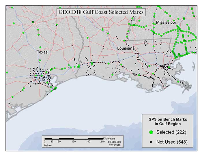
GPS on Bench Marks for GEOID18 in the Gulf Coast Region
Figure 1: GEOID18 Gulf Coast selected marks: There are areas of complex vertical crustal motion in the Texas/Louisiana Gulf Coast region of the United States which render many control station elevations in the region invalid. The selection of GPS on Bench Marks in this region was limited to the small number of marks where the leveling and GPS data agreed to minimize the influence of crustal motion in the hybrid geoid model. Figure 1 depicts the selection of stations used in the hybrid geoid model along the Texas/Louisiana Gulf Coast. (Image: National Geodetic Survey)
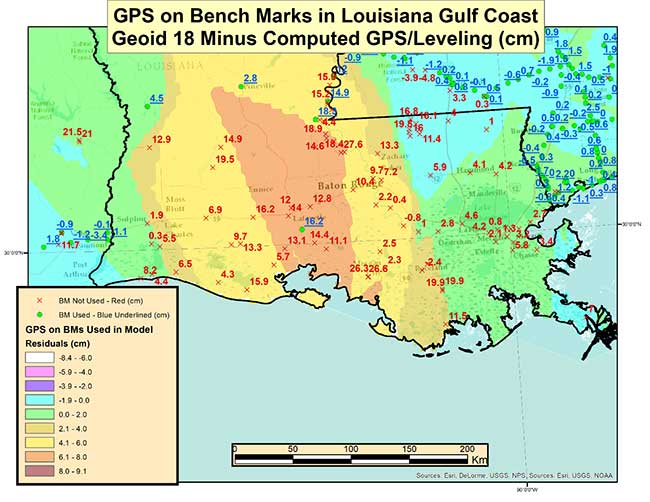
As highlighted in the last column, very few stations in Southern Louisiana were used in the creation of the Geoid18 hybrid geoid model. As provided in my last column the box titled “Differences on GPS on Bench Marks in the Gulf Coast Region” depicts the differences between the published Geoid18 value and the computed geoid value using the latest NAD 83 (2011) ellipsoid and NAVD 88 orthometric height.
Differences on GPS on Bench Marks in the Gulf Coast Region
Image: National Geodetic Survey
The plot indicates that there are many large differences. Many of these differences are to be expected because the Southern Louisiana is an area of known crustal movement. NGS recognizes this and includes the statement below on datasheets for stations published in Southern Louisiana (see box titled “Statement on NGS Datasheet for Stations in Southern Louisiana”).
Statement on NGS Datasheet for Stations in Southern Louisiana
This station is in an area of known vertical motion. Due to the variability of land subsidence, uplift, and crustal motion, NGS has, determined the orthometric heights for marks in these suspect subsidence areas should be considered valid only at the epoch date associated with the orthometric height. These heights must always be validated when used as control. All previously superseded orthometric heights are now considered suspect and are available in the superseded section. NGS does not recommend using suspect or superseded heights as control.
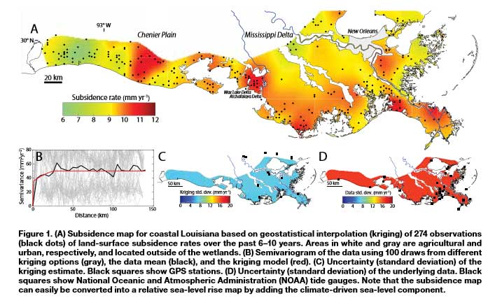
Looking at the figure indicates that there is a significant variation of subsidence occurring in coastal Louisiana. The legend indicates that the subsidence rates range between 0.6 to 1.2 cm/year.
Figure 1 from A New Subsidence Map for Coastal Louisiana
The box titled “Excerpt from Anthropogenic and Geologic Influences on Subsidence in the Vicinity of New Orleans, Louisiana” depicts estimates of crustal movement between 2009 and 2012 in the vicinity of New Orleans. Several of the areas in the plot indicate subsidence rates exceeding -1 cm/year. Once again, the figure shows the local variability of subsidence rates.
Excerpt from Anthropogenic and Geologic Influences on Subsidence in the Vicinity of New Orleans, Louisiana
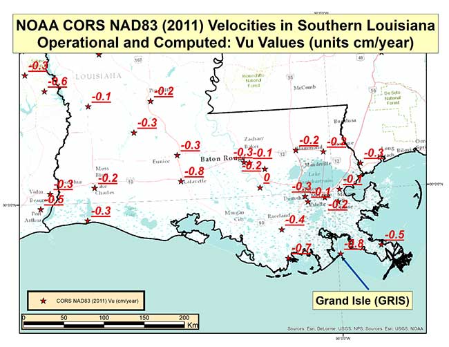
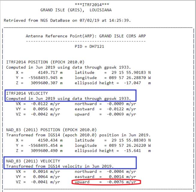
Last year, NGS performed the Multi-Year CORS Solution 2 (MYCS2). This was described in previous columns, which can be viewed here and here. The MYCS2 process generated computed and modeled velocities for CORSs. The box titled “CORS NAD83 (2011) Vu Velocities” is a plot that depicts the velocities in the “upward” component in cm/year for NOAA CORS that are operational and have a computed velocity in Southern Louisiana. So, what does this mean to estimating a hybrid geoid model in Southern Louisiana?
CORS NAD83 (2011) Vu Velocities
Image: National Geodetic Survey
The plot indicates that the rates vary from -0.1 cm to -0.8 cm. It should be noted that these stations are CORS and they are typically installed on structures that may not capture the entire amount of subsidence at the land surface. The box titled “CORS Position and Velocity for Station GRIS” provides an example of a CORS sheet from NGS CORS website.
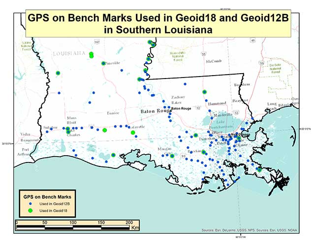
Now, let’s look at differences between Geoid12B and Geoid18 in Southern Louisiana. The box titled “GPS on Bench Marks Used in Geoid18 and Geoid12B” depicts the stations used in Geoid12 and those used in Geoid 18. As indicated in the plots, there were a lot more stations used in the generation of the Geoid12B model than those used to create the Geoid18 model.
GPS on Bench Marks Used in Geoid18 and Geoid12B
Photo: National Geodetic Survey
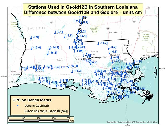
The box titled “Differences between Geoid12B and Geoid18 in Southern Louisiana” provides the values of Geoid12B minus Geoid18 in centimeters on the GPS in Bench Mark stations used in Geoid12B.
Differences between Geoid12B and Geoid18 in Southern Louisiana
Photo: National Geodetic Survey
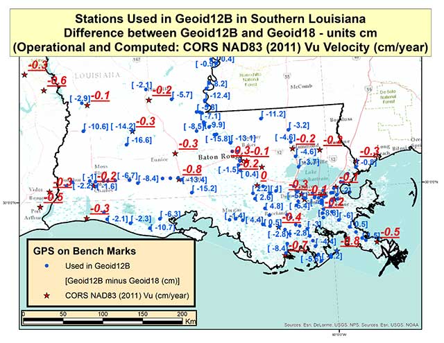
As indicated in the plot, there are some large differences between Geoid12B and Geoid18 values; a few differences exceed 15 centimeters. Based on the previous discussion of crustal movement in Southern Louisiana, this probably shouldn’t come as a surprise. The box titled “Differences between Geoid12B and Geoid18 with Vu Velocity Values” depicts the differences in the hybrid geoid models and the NAD83 (2011) CORS Vu rate.
Differences between Geoid12B and Geoid18 with Vu Velocity Values
Photo: National Geodetic Survey
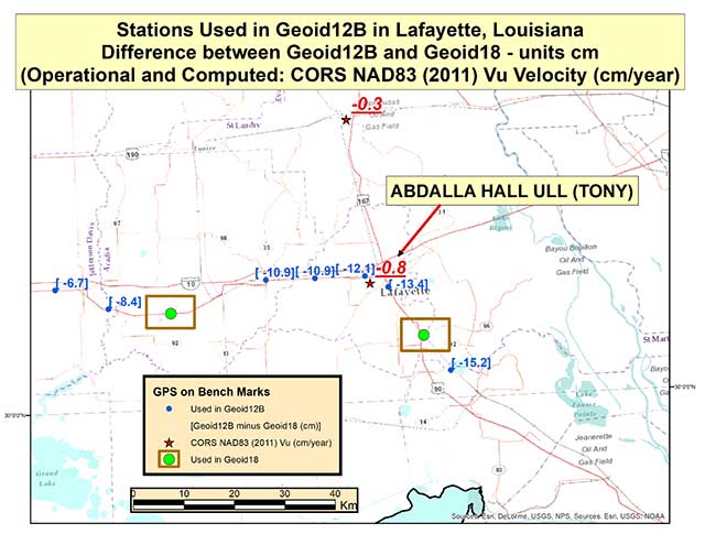
The box titled “Differences between Geoid12B and Geoid18 in Lafayette, Louisiana” depicts the differences in the two hybrid geoid models and the NAD83 (2011) CORS Vu rate values in the Lafayette, Louisiana, region. This region has some of the largest differences between Geoid12B and Geoid18 values in Southern Louisiana. As indicated in the plot, CORS station TONY has a Vu rate of -0.8 cm/year which is fairly large, and the differences between Geoid12B and Geoid18 values are fairly large at the -10 to -15 cm level. Once again, users should expect differences between the two hybrid geoid models because there has been movement in the area and because different GPS on Bench Mark stations were used in the generation of the hybrid geoid models. In the Lafayette region the two stations used in the generation of Geoid18 were not used in Geoid12B (see stations highlighted in a box).
Differences between Geoid12B and Geoid18 in Lafayette, Louisiana
Photo: National Geodetic Survey
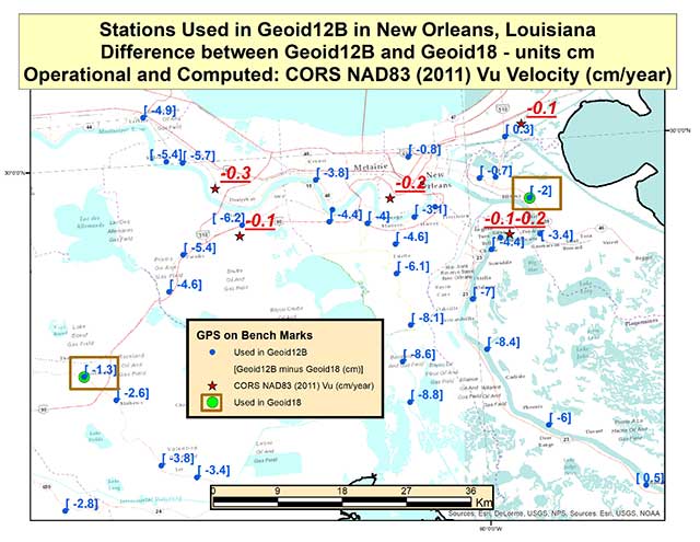
The box titled “Differences between Geoid12B and Geoid18 in New Orleans, Louisiana” depicts the differences in the hybrid geoid models and the NAD83 (2011) CORS Vu rate values in the New Orleans, Louisiana, region. Two of the same stations that were used in the development of Geoid12B and Geoid18 are highlighted with a box. The difference between the two geoid model values are much less in this region compared with the Lafayette region. The CORS Vu velocities are also less than the CORS station (TONY) value in Lafayette. Saying that, the differences on stations not used in Geoid18 have differences ranging from -4 to -8 cm going southward toward the Gulf of Mexico. Once again, Southern Louisiana is subsiding so these differences are not surprising.
Differences between Geoid12B and Geoid18 in New Orleans, Louisiana
Photo: National Geodetic Survey
This means if someone uses NGS’ OPUS web tool to compute a GNSS-derived orthometric height, the NAVD 88 GNSS-derived orthometric height could be significantly different than the published stations in this region. Some of the difference could be due to the difference between the Geoid12B and Geoid18 published values, and some could be due to crustal movement in Southern Louisiana. Saying that, I mentioned in my last column that NGS performed a large GNSS network project in Southern Louisiana in 2016. The GNSS-derived ellipsoid heights were loaded in NGS’ database in March 2019, but the GNSS-derived orthometric height from the 2016 project are not yet finalized so they have not been loaded into NGS’ database. Once finalized and loaded into the database, the 2016 GNSS-derived orthometric heights should be more consistent with GNSS-derived orthometric heights estimated using the NGS’ OPUS web tool. This column focused on differences between published Geoid18 values and Geoid12B values in Southern Louisiana. It provided reasons why users may see large differences between the two models.
Technology continues to develop and put more capability, data storage and ease of use into many professional’s hands, and surveyors are no different in their needs.
Spatial data collection has become an important task in the diverse service world of today’s surveyor with a variety of platforms, sensors and techniques being used to provide this operation.
The movement toward completing a “digital twin” of existing improvements and facilities worldwide has opened the door for new means and methods for data collection. Surveyors are taking a front-line role in producing the spatial data necessary for much of the internal and external infrastructure being used in today’s cutting-edge digital modeling.
Necessary accuracy and precision
However, not all data-collection systems offer the accuracy and precision deemed necessary by today’s surveying profession. These systems also need to be tough enough to handle the environmental conditions surveyors face in their everyday work, yet be user-friendly enough to make the data-collection process efficient.
Surveyors require a system designed for rugged use, yet built with a high-visibility screen, easy-to-use interface and reasonable battery life to allow effective and confident data collection. Many data collectors tout these features, but many of them fail when subjected to the harsh conditions of surveying and construction sites.
Times, however, are a changing and a new tablet is raising eyebrows.
DT Research Inc., a Silicon Valley electronics provider, has provided mobile and medical computing devices to many professions for more than 20 years. They have taken one of their most popular models, the DT301, and added integrated significant upgrades that brings it squarely into the surveying and geospatial world.
This rugged tablet can now include a multi-frequency GNSS module and a second, 3D-capable, stereo-imaging camera for capturing photometric information.
High-capacity, hot-swappable battery pack with power-saving modes
IP65-rated for water and dust resistance
MIL-STD-810G for shock and vibration protection
MIL-STD-461F for EMI and EMC tolerance
Multi-frequency GNSS (including GPS, GLONASS, Galileo and BeiDou)
External GNSS antenna capable
Intel RealSense Depth camera, 2D barcode scanner
Long-range Bluetooth, 4G LTE, digital pen support
Sturdy external keyboard with various mounts for static installation
Rugged yet reasonable weight of 3.1 pounds
Multiple mounting options for precise measurement
Rugged, but not too heavy
The first impression a new user of the DT301X-TR will notice is that while it is heavier than the normal personal tablet, it is very rugged yet not noticeably heavy. The additional weight it does carry, however, gives the user a sense of durability and confidence to take it into fouler environments without fear of infiltration or hazardous climate concerns.
The external bumpers can take significant abuse, and the rubber rear guard is used for gripping the tablet effectively during data collection tasks. Several mounts are available for this unit, including a pole mount in conjunction with the external GNSS antenna for higher accuracy location determination.
This unit runs the Microsoft Windows 10 IoT (internet of things) Enterprise operating system, so most users will already have a general feel for the overall interface. All the normal Windows tools are there (email, browser, etc.), so little training is needed for beginners.
Connectivity is available through dual-band Wi-Fi and/or 4G LTE communications as well as long-range Bluetooth connections where needed. The unit runs on an Intel 8th-generation core processor and SSD storage for fast computing and data access needs.
In addition to computing performance, this model also exceeds expectations with its robust screen. Where most high-def screens on phones and tablets suffer in daylight conditions, the DT301X-TR allows the user to maintain great visibility and keep working with visual confidence.
GNSS module and antenna
The DT301X-TR can be loaded with several data-collection software packages, depending on your application. For traditional surveying, Microsurvey’s Field Genius is used for locating survey points with the GNSS module. Several programs for data collection are available, depending on the accuracy required by the user.
Photo: DT Research
A helical mobile dual-frequency GNSS antenna is mounted directly on the tablet for receiving survey-grade positions with an RTK correction service. The tablet can also be used with an external GNSS antenna mounted on an extendable pole for a more conventional surveyor-style method of data collection while providing stability for the user.
The data-collection process for mapping is intuitive and allows for uploading existing shapefiles for reference to existing conditions. Exporting information after the data-collection task can be completed in two different formats: shapefiles and KML files.
Photo: DT Research
For the higher accuracies typically required for surveyors, the unit utilizes the pole mount to ensure the accuracy level is not compromised by human interaction, and it connects to an external GNSS antenna. The software allows the user to collect more precise locations through several means: static, real-time kinematic from the user’s base station, or through a real-time network solution from an external source.
The data collection process in Field Genius is very user friendly and allows for customized point naming and automatic linework between points. Field Genius also contains standard COGO tools and routines that allow the user to perform field calculations right on the job, saving valuable time and money for the practitioner and the client.
Exporting of field data is robust and allows for creation of DXF/DWG files of linework and LandXML files for surface and point downloads. The user can also export raw data in a GNSS Survey format or the industry standard “field book” format as well. Importing background files is just as simple, so the user can have additional information at their fingertips for reference during their data collection process.
Also, the DT301X-TR can be utilized for construction staking with an extensive array of staking reports available for user verification. Proposed TIN surface models can be imported for site and roadway staking for placing cut/fill points on the fly.
Cameras make it shine
The DT301X-TR, however, is not just a fancy conventional surveying data collector; the Intel RealSense Depth camera and DOT3D Pro software from DOT Product is the latest development to be added to the rugged tablet that makes this platform shine. This latest technology from Intel allows the user to photograph and video spaces that even the newest laser and lidar scanning equipment can’t access.
Stereo depth modeling is enhancing the data-collection process for surveyors as a new tool to collect important information for engineers, architects and contractors. By collecting close quarters information in real time, a more complete BIM and/or “digital twin” data set can be accomplished faster and more cost efficiently than ever.
This version of remote sensing is becoming very popular with other vehicles and platforms (such as UAVs), yet being integrated into a single unit with GNSS capability is key to making the DT301X-TR a game changer.
The divide between the macro (GIS mapping) and micro (traditional surveying) of spatial data collection is closing, but it will take some time before satisfying the surveying community. The DT301X-TR is closing that gap by marrying the accuracy of GNSS measurement with the precision of 3D analyzation technology.
DT Research began by creating a bulletproof tablet made for durability and dependability, but has raised the bar with a state-of-the-art satellite measurement module and remote-sensing capability through the RealSense camera system.
Wrapping all this technology into a rugged unit running on an industry-standard software platform, DT Research has provided an insight to what the future of data collection looks like, no matter what profession one is in.
The U.S. Department of Transportation (DOT) announced competitive grant solicitation for a new University Transportation Center (UTC) specifically on Highly Automated Transportation Research.
Photo: Resilient PNT Foundation
“People will not be comfortable getting into an automated vehicle or with platooning driverless trucks heading down the highway if they think… their GPS might be spoofed,” according to Diana Furchtgott-Roth, Deputy Assistant Secretary at the U.S. Department of Transportation at a recent presentation. She believes getting robust and resilient navigation right is a prerequisite for success with automated and autonomous systems.
As part of this effort, her office is looking for a U.S. non-profit institution of higher learning to become a University Transportation Center (UTC) focusing on “Highly Automated Transportation Research.” A critical component of this new center’s efforts will be work on resilient positioning, navigation and timing (PNT) services.
From the abstract:
“Progress on the path toward integrating automated systems into the transportation domain for all modes of transportation (surface, aviation, and maritime) will be aided by additional research addressing challenges associated with ensuring resilient Positioning, Navigation, and Timing (PNT) services to support automated systems.
“This University Transportation Center will complement the new Center of Excellence for Highly Automated Transportation Systems being implemented within the USDOT. Among the critical needs is research to support securing cyber resilient PNT receivers for use in automated systems. This UTC will carry out research to support the development of standards and or prototypes and incorporate existing U.S. Government guidance.“
The department is also looking for UTCs for Communications Technology and E-Commerce Effects on Travel Demand; Implications of Accessible Automated Vehicles and Mobility Services for People with Disabilities; and Strategic Implications of Changing Public Transportation Travel Trends.
According to a press release issued March 30, one institution will be selected in each of the four areas. The total initial funding available to is just shy of $5 million.
What are the key obstacles to widespread adoption of 3D positioning and guidance in the construction industry?
Ismael Colomina, GeoNumerics
“Construction site monitoring with UAVs requires regulated standard scenarios that allow flying over people and in urban areas without spending weeks obtaining the needed permissions. It also requires the development of critical UAV components, especially the guidance, navigation and control (GNC) systems. Safe UAV navigation — guaranteeing positional accuracy with small probabilities of actual errors larger than the specified ones — is still under development and will involve a multi-sensor navigation system. Current GNSS augmentation systems, such as WAAS and EGNOS, may not be appropriate for flights in the very-low-level (VLL) airspace.” Ismael Colomina, GeoNumerics
Members of the EAB
Tony Agresta Nearmap
Miguel Amor Hexagon Positioning Intelligence
Thibault Bonnevie SBG Systems
Alison Brown NAVSYS Corporation
Ismael Colomina GeoNumerics
Clem Driscoll C.J. Driscoll & Associates
John Fischer Orolia
Ellen Hall Spirent Federal Systems
Jules McNeff Overlook Systems Technologies, Inc.
Terry Moore University of Nottingham
Bradford W. Parkinson Stanford Center for Position, Navigation and Time
No, I’m not talking about the line at the grocery store to buy toilet paper and hand sanitizer. Or the line at the doctor’s office. I’m talking about that gray privacy line invisible to the naked eye, but all too accessible on our mobile devices.
On March 16, Israeli Prime Minister Benjamin Netanyahu and his cabinet approved using citizens’ smartphones to track the locations of people infected with the novel coronavirus (COVID-19), as well as anyone they might have had contact with.
Such a strategy might work — some citizens reported receiving smartphone alerts when they were near an infected person. However, it does raise the ubiquitous privacy concerns of allowing your government to know your every move.
Some may think this an acceptable use of tracking, except that the Israeli Knesset — the citizenry’s representative legislature — was not involved in the decision. The tracking didn’t require a court order, and records were to be kept until the new regulation expired.
A few days later, Israel’s top court put a stop to the program, saying there would be no tracking of Israelis by the Shin Bet without Knesset oversight.
Of course, Israel is a democracy, and Netanyahu’s move is nowhere near the draconian measures undertaken by the Chinese government in response to the virus. Those actions included forcibly removing people from their homes and placing them in quarantine.
Yet China’s actions worked. As of press time, the outbreak there is under control, with no new cases reported on March 19. That’s impressive, if one can trust the state news. After all, this is the same country that warned the doctor who discovered the virus not to talk about it. Dr. Li Wenliang died in February of the disease.
Privacy versus public health: Something to think about while social distancing at home.
A couple of interesting drone applications came up this month — marine smoke emission monitoring and studies from a little known European drone manufacturer.
Monitoring marine emissions
Climate change: Some might say these are words we don’t really need to hear. Such a big to-do about how much human activity is affecting the weather changes that we are now seeing globally. Or is it all part of a natural cycle that the Earth is going through as many might say?
I don’t really want to get into that argument, but it would seem useful that someone is doing something to reduce the use of dirty fuels by ships. After all, we seemed to readily acquiesce to unleaded fuel for our vehicles without a lot of protest; why would we accept this as the norm when marine transport still uses dirty bunker fuel, belching out a significant amount of pollution?
If it’s good for people and their cars, and we quite possibly incurred some costs getting there, why not stick it on the marine industry too?
So that’s what the International Maritime Organization (IMO) did in January this year, reducing the allowable sulphur content in marine fuel from 3.5 to 0.5%. Enforced under the international convention for the prevention of pollution from ships, this is aimed at cutting sulphur oxide emissions from ships by 77%, equivalent to a reduction of about 8.5 million metric tons annually.
That’s the tricky bit – enforcement. Ships spend most of their time miles away from land, so knowing what their smoke emissions contain is somewhat difficult. Now (this is where I manage to tie things back to what I’m supposed to be reporting on) its useful that Schiebel, along with its partner operator Nordic Unmanned, thought about enforcement of the new regulations.
Schiebel Camcopter S-100. (Photo: Schiebel)
With a range of up to 200 kilometers (~125 miles) the Camcopter S-100 can get out to the shipping lanes to check on what’s coming out of the smokestacks. Equipped with an automatic identification system (AIS), a sulphur sniffing sensor and an L3 Harris Wescam MX-10 real-time electro-optical/infrared (EO/IR) camera, the “enforcement drone” can determine which ship it’s flying over, what the smoke plume sulphur content might be, and even take geo-coded pictures to show in which jurisdiction the ship is sailing. If necessary, it can even take pictures of who’s throwing what at the overflying UAV.
In recent tests, the Camcopter flew out of Gniben, Denmark, where European regulations on emissions applied, and marine exhaust fumes are limited to contain no more than 0.1 percent sulphur oxide. The Camcopter S-100 performed two 4- hour flights and provided real-time readings of the sulphur level in ships’ exhaust plumes.
With these successful tests in the bag, Nordic Unmanned has indicated its capabilities to worldwide maritime authorities that they are ready and able to help enforce the new IMO regulations.
European-built multi-rotor drone
Acecore Technologies in the Netherlands makes multi-rotor drones which have found some unique applications:
The NEO 8-rotor UAV. (Photo: Acecore)
Stringing power-lines using NEO (SPIE website)
In order to extend power transmission line capacity, the approach used is often to first pull a lead cable. This normally involves several power company personnel and a whole bunch of specialized equipment.
However, in a first-of-its-kind test, SPIE Nederland used an Acecore NEO drone to pull a lead cable over 150 meters between high-voltage pylons.
Equipped with suitable cameras and other sensors, Acecore drones have also been used for power-line and gas-plant thermal inspection, movie making (including Game of Thrones), live broadcasts, autonomous aerial surveying, and tethered security applications. They also make crop health monitoring possible.
Designed with durability in mind, Acecore drones are weather-proof, built with strong carbon-fiber frames, have triple redundant autopilots, and are ADS-B-ready to broadcast GPS position to support sense-and-avoid capability.
Acecore is also promoting the fact that its drones and controllers are manufactured entirely with European parts. In other words, they would like to grab a chunk of DJI’s huge market share by jumping on an apparent global move to switch over from Chinese sourced goods and equipment.
So, drones are taking on environmental monitoring. They’re reducing the environmental impact of transmission-line build-out. And they’re moving toward building drones locally — all are interesting new applications of unmanned aircraft systems.