Guest column by Brian Wynne AUVSI President and CEO
Brian Wynne, AUVSI president and CEO
A recent analysis found that just 10 percent of the unmanned aircraft systems (UAS) included in the Unmanned Systems and Robotics Database maintained by the Association for Unmanned Vehicle Systems International (AUVSI) can operate beyond the visual line of sight (BVLOS) of its operator.
While the technology for BVLOS operations has existed for years, under current federal regulations, only the military is permitted to use it. The absence of federal regulation allowing BVLOS operations hinders the full value and benefits that the UAS industry has to offer.
Regulations that provide guidance and rules for operating unmanned systems are necessary for the industry’s advancement. Earlier this year, the Federal Aviation Administration (FAA) issued a proposed rule for UAS operations over people, and the UAS community is eagerly anticipating the agency will offer an additional rule requiring UAS to be equipped with remote identification.
“Remote ID is a crucial next step to gain the confidence of federal defense and security agencies, manned aviation users and the public.”
However, the rulemaking process for remote ID has been delayed by the FAA twice this year and is now slated to be released in December. The need for remote ID cannot be overstated, as the advancement of the UAS industry depends on identifying and tracking UAS flying in the airspace.
Furthermore, remote ID is a crucial next step to gain the confidence of federal defense and security agencies, manned aviation users and the public. With this confidence, UAS can further integrate into the national airspace to perform important BVLOS operations such as inspection of utility rights of way, widespread search-and-rescue missions, and package delivery.
A clear, national regulatory framework and the support of the federal government is needed to drive the adoption of unmanned systems technology and its applications. Currently, the UAS industry is working with our government partners on remote ID and tracking standards, but we recognize that more needs to be done and at a faster pace than the regulatory process allows. That is why the UAS industry is stepping up to explore near-term solutions before remote ID regulations are finalized and published.
In May, AUVSI and the Airports Council International-North America commissioned a Blue Ribbon Task Force on UAS Mitigation at Airports. The task force is working to refine procedural practices and provide a policy framework to address the timely and critical issue of incursions by unauthorized UAS at airports and how best to mitigate this threat, including industry and government recommendations for remote ID. The task force will release a report this year.
Applications of unmanned systems aren’t limited by technology or imagination; they’re only limited by regulations. We need a streamlined regulatory environment that allows for the safe deployment of unmanned systems into our nation’s transportation infrastructure so we can begin to reap the full benefits of this technology.
We used to divide GPS receivers into consumer grade, resource grade and survey grade. Have these categories been replaced by a continuum of GNSS capabilities?
Clem Driscoll
“In the U.S. commercial telematics market, GPS remains the primary source of location data, with very little reliance on other GNSS networks. A bigger issue is the generation of cellular networks used to transmit GPS data, with 3G network sunsets pending and 5G on the horizon. As autonomous commercial vehicles become closer to a reality, multiple GNSS networks and differential techniques will become essential. These solutions are currently in development.” Clem Driscoll
C.J. Driscoll & Associates
Greg Turetzky
“No. These categories still define important hardware distinctions (such as antenna) and required correction services that define the achievable specifications. Although they all have correlators, they have very different architectures; however, resource and survey have a blurrier line.” Greg Turetzky
Consultant
Members of the EAB
Tony Agresta Nearmap
Miguel Amor Hexagon Positioning Intelligence
Thibault Bonnevie SBG Systems
Alison Brown NAVSYS Corporation
Ismael Colomina GeoNumerics
Clem Driscoll C.J. Driscoll & Associates
John Fischer Orolia
Ellen Hall Spirent Federal Systems
Jules McNeff Overlook Systems Technologies, Inc.
Terry Moore University of Nottingham
Bradford W. Parkinson Stanford Center for Position, Navigation and Time
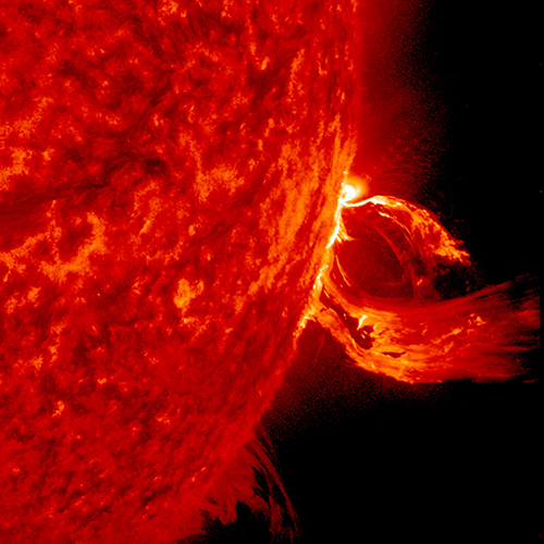
A solar flare in 2015. (Photo: Photo: Solar Dynamics Observatory, NASA)
You wake up and turn on the TV. Your usual shows aren’t airing. You flip on the radio and learn that the Paris and Tokyo stock markets have closed. Back on TV, CNN is trying to use Skype in an attempt to cover what’s happening around the world following a solar superstorm.
In a U.S. bunker, the military has lost contact with armed drones flying over hostile areas in the Middle East. Loss of global communication satellites makes it difficult to send commands and surveillance data to soldiers, ships and aircraft, rendering them vulnerable to attack.
Throughout the day, more challenges arise. First responders don’t have access to their location systems. Delays in ground and air traffic begin to develop. Systems that depend on GPS time stamps — ATMs, power grids, computer-data and cell-phone networks — begin to fail, and the cloud becomes unstable. The internet soon collapses.
These events take place just a few hours into “A Day Without Satellites” as presented by Pål Brekke, solar physicist and senior advisor at the Norwegian Space Agency. Brekke spoke at the plenary session of ION GNSS+ on Sept. 17 in Miami.
Brekke reviewed the Carrington Event of September 1859, the first documented solar superstorm. In that event, a solar coronal mass ejection (CME) hit Earth’s magnetosphere, and its effects were observed and recorded by British astronomers. The storm wrought havoc with telegraph systems.
Today, a solar storm of this magnitude would cause widespread disruptions, blackouts and damage from extended outages of the power grid, communications networks, and of course, GNSS. The solar storm of 2012 was probably as big, but we were lucky — Earth wasn’t in the ejection path.
Without more data, it’s difficult to predict how often such superstorms take place, but it’s a sure bet that the scenario Brekke presented will happen eventually. To prepare, agencies around the world are studying and planning for the phenomenon, including the United Nations Office for Outer Space Affairs (COPUOS), the World Meteorological Organization (WMO) and the International Civil Aviation Organization (ICAO). Space and emergency agencies in the U.S, European countries and other countries are also developing plans.
Good to hear in the face of a threat that would undoubtedly affect us all.
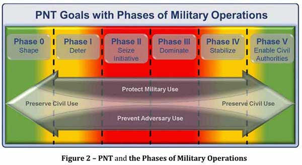
Calling PNT “foundational,” the strategy observes that the U.S. military has over the years structured its weapons systems and business processes around GPS PNT. This has created a tremendous dependence and associated vulnerability.
Added to this threat is the realization that “At the same time, it is increasingly clear… GPS will be targeted and will not always be available in contested military operating areas, or perhaps globally.”
Multiple diverse sources of PNT
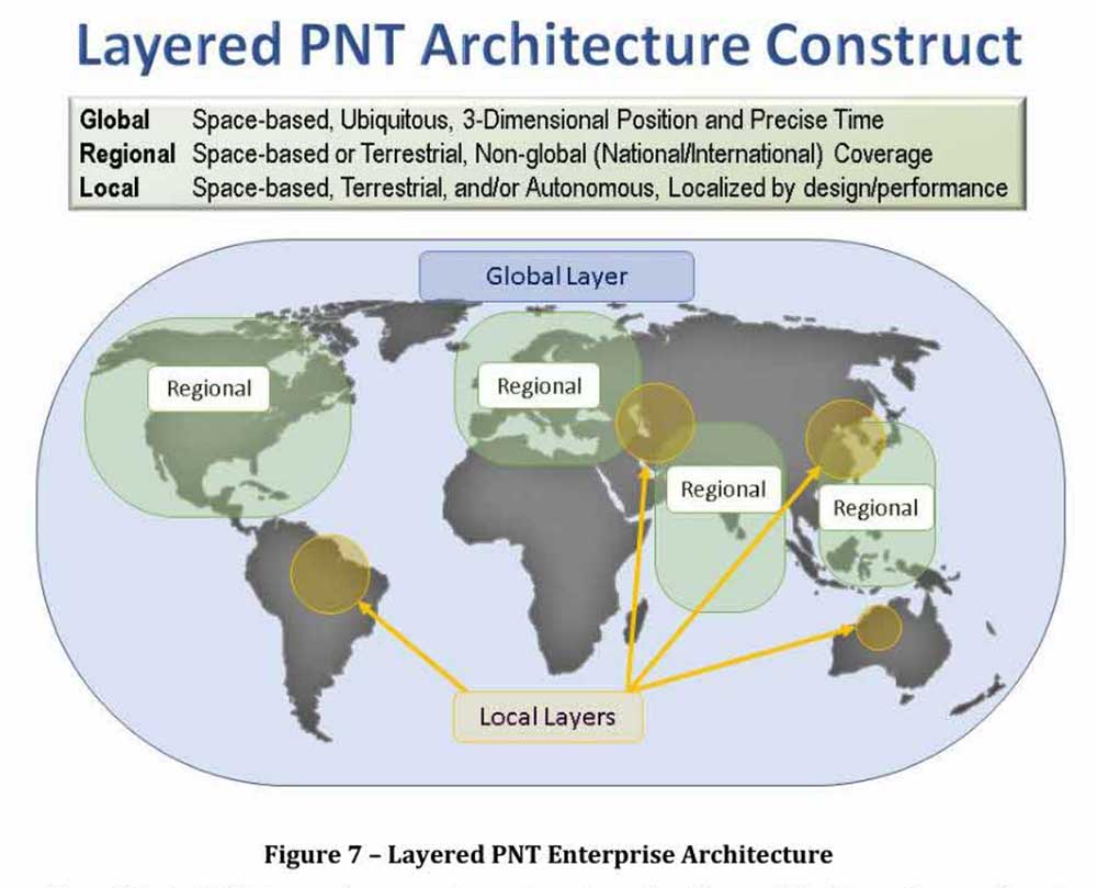
One of the primary ways DoD will deal with is this is to access multiple diverse sources of PNT. These will be in a multi-layered architecture of global, regional and local services.
The strategy envisions GPS, paired with military-grade receivers, as the primary global layer source. It recognizes that allied GNSS will be available, but observes that DoD has not done any accuracy and integrity assessments to determine their usefulness. And, since “…all are vulnerable to the same interference and jamming effects” as GPS, “…other sources of PNT information with different characteristics are necessary.”
The regional layer is defined by systems that service large areas such as a few countries or even continents. Recognizing that regional sources can be in space, the strategy discusses two low-frequency ground-based systems with characteristics much different from satellites — enhanced Loran (eLoran) and spatial, temporal and orientation information in contested environments (STOIC).
“Their high power and low frequency enable regional/nationwide coverage, spectrally separate from GPS services, accessible in buildings and under water, and transmitted from dispersed terrestrial locations. Each can be considered as a possible complement to GPS, depending upon operational circumstances and requirements.”
Short-range radio frequency systems, clock, inertial, sensory and hybrid PNT services integrated with wireless networks are all cited as possible contributors to the local layer of DoD’s PNT architecture.
Modular, open-systems approach
Receivers that employ a modular, open-systems approach that can ingest and integrate the various sources of PNT information are needed to take advantage of this multi-source, multi-layer strategy. And integration of the various sources must be seamless and invisible to the user, unless they decide otherwise.
“The employment of multiple PNT sources should not require user awareness or intervention to switch among alternatives during mission execution unless the user elects that option.”
A critical need for implementing this approach, according to the strategy, is the establishment of PNT input/output standards. The document notes that candidate standards have been developed, and it is vital to finalize and approve the standards and bring them into operational service as soon as possible.
Other provisions
The strategy includes a number of other provisions regarding internal DoD processes, the complicated governance process for PNT within the department, and some complex graphics that may be of interest to the larger PNT community.
It also sends several messages about the department’s desires, intent and concerns in the world of PNT that are worth noting.
NAVWAR. The department’s main defensive capability during navigation warfare will be the use of its layered architecture of PNT information and modular, open-systems integration. For offensive operations, it cautions warfighters to not shoot themselves in the foot. PNT is so vital to a wide variety of allied systems, it warns, that denying it to hostiles could do as much damage to friendly forces.
PNT dominience/superiority. At at time when there are more of China’s brand new BeiDou satellites in the skies of many cities, and China is negotiating with Russia for closer BeiDou/GLONASS integration, the strategy calls for the U.S. DoD to achieve PNT dominance. To date, U.S. PNT leadership has been a big contributor to the nation’s political and military leadership in the world. The strategy seeks to continue this.
Accelerate M-code receivers. The need to get more M-code GPS receivers into the hands of warfighters is mentioned several times. GPS III satellites have been transmitting M-coded signals that are much more resilient to jamming and spoofing than civil signals since late 2018. These are useless, though, without properly equipped receivers in the field.
Future support to Civil PNT. The strategy also seems to show the department is distancing itself from support of future civil PNT endeavors. While GPS has been an incredible economic engine and boon to civil users, this has not always been in DoD’s best interests.
“It must also be recognized that in this context growing civil dependence on GPS services for critical infrastructure and public use will continue to constrain the ability of the DoD to maintain a military PNT advantage from GPS.”
It goes on to warn that future DoD PNT systems and efforts will not follow the same path to civil-military use as was taken by GPS.
“DOD must take steps to ensure the civil agencies are aware of and are sensitive to the dual-use implications inherent in GPS and other PNT Enterprise applications. From this point forward, many of the specific PNT capabilities and combinations of PNT capabilities employed by the DoD for military purposes will increasingly be classified.”
The way ahead for the 99%
It is clear that the Department of Defense, through the very capable leadership of its CIO, Dana Deasy, has a clear idea of where it is with PNT, its critical challenges, and how to overcome them.
This does not appear to be the case for those in the federal government charged with safeguarding the interests of civil users. With responsibilities fragmented across a host of departments and agencies, efforts on behalf of the public at large are barely visible compared to those the Defense Department is taking to protect itself.
According to officials, this may change. They report that leadership of civil PNT within the executive branch is under review with an eye to making it more efficient and effective.
Perhaps it will result in a PNT strategy for the 99% of GPS users who are not connected with the Defense establishment, making them safer and more secure as well.
“Strategy for the Department of Defense Positioning, Navigation, and Timing (PNT) Enterprise” is available online.
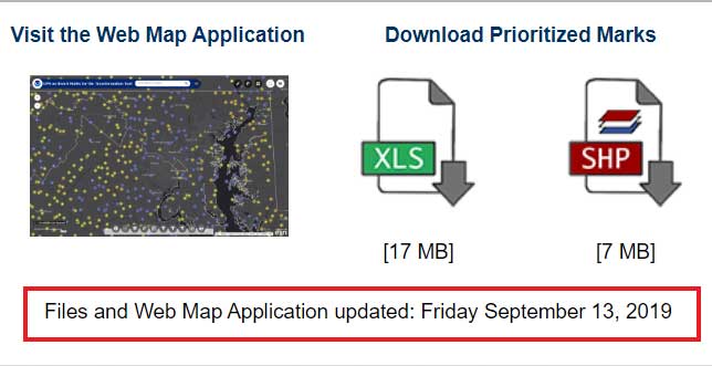
My last column highlighted the next phase of the National Geodetic Survey’s (NGS) GPS on Bench Marks program; that is, the development of the 2022 transformation model. It provided web links to material explaining the new GPS on Bench Marks program. NGS continues to update this site so I would encourage users to periodically check the site for updates. At the time of this column, the site was updated on Sept. 13. See the box titled “GPS on Bench Mark Web Page.”
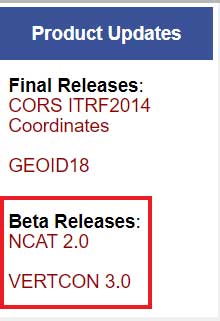
This column is going to focus on the newly released beta version of NCAT 2.0, which includes the new beta version of VERTCON 3.0. See the box titled “NGS Product Updates.”
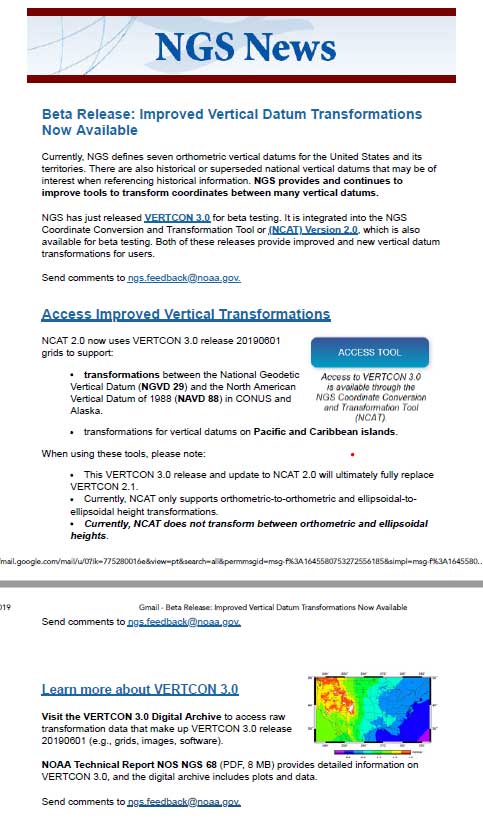
On Sept. 24, NGS sent an NGS News Update through its data delivery system. See the box titled “NGS News Announcement of VERTCON 3.0.”
NGS News Announcement of VERTCON 3.0
Image: National Geodetic Survey
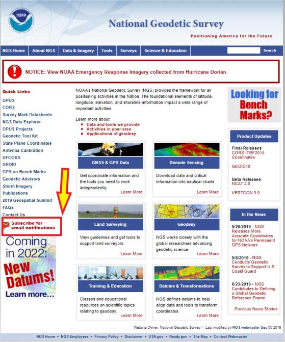
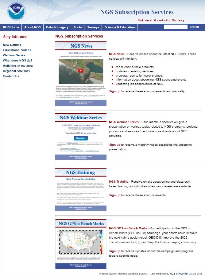
As a side note, anyone can sign up for NGS News announcements by clicking on the button titled “Subscribe for email notifications” on the left side of NGS Home Page. See the box titled “Subscribe for NGS Email Notifications “
First, NGS published a technical document that provides a brief history of previous versions of the VERTCON model and the technical details of the new beta VERTCON 3.0 model. The report is titled “NOAA Technical Report NOS NGS 68,The VERTCON 3.0 Project” and can be downloaded here.
NGS decided to update the existing VERTCON tool with two primary purposes in mind:
to support as many of the vertical datums of the NSRS as possible, and
to prepare users for the new North American-Pacific Geopotential Datum of 2022 (NAPGD2022).
NGS plans include incorporating the new VERTCON 3.0 model into its integrated products and services. See the box titled “Excerpt from NOAA Technical Report NOS NGS 68, The VERTCON 3.0 Project: Motivation for VERTCON 3.0.”
As a matter of fact, the beta version of VERTCON 3.0 is included in an updated beta version of the NGS Coordinate Conversion and Datum Transformation Tool (NCAT). This column will provide examples converting NGVD 29 heights to NAVD 88 heights using the new beta versions of NCAT and VERTCON.
Excerpt from NOAA Technical Report NOS NGS 68, The VERTCON 3.0 Project: Motivation for VERTCON 3.0
The greatest driver for VERTCON 3.0 was the pending release of NAPGD2022, expected in late 2022. As part of that release, NGS intends to release grids to transform between existing vertical datums and NAPGD2022. As the build software used to create all previous versions of VERTCON was no longer available, it was decided (like NADCON; see Smith and Bilich, 2017) to completely recreate the entire suite of VERTCON build software.
However, unlike horizontal datums, the history of vertical datums at NGS is, as mentioned earlier, quite limited. As a transformation can only exist if two datums are released in a region, this limits what expansion to VERTCON 2.1 might be possible. Nonetheless, most regions at least had “Local Tidal” heights published by NGS as well as some other official vertical datum of the NSRS, so a decision to support transformation in these regions was made.
Knowing that such a re-build would replace VERTCON 2.1, the new project and its build software were designated from the beginning as “VERTCON 3.0”.
Other expected advantages with this project were the chance to update documentation and the delivery of the transformations, through incorporation into newly integrated products and services like the NGS Coordinate Conversion and Datum Transformation Tool (NCAT, available at https://www.ngs.noaa.gov/NCAT/) and VDatum (available at https://vdatum.noaa.gov/).
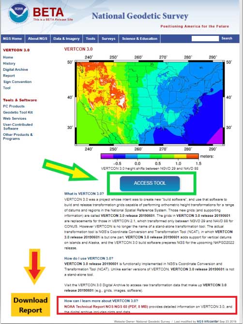
Users can access the VERTCON 3.0 model by clicking on the VERTCON 3.0 link on NGS Home Page. It will direct the user to this website.
See box titled “VERTCON 3.0 Web Site.” The user can also download the Technical Report from this site.
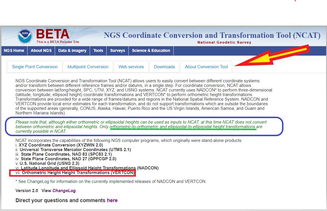
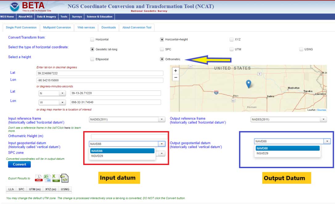
Clicking on the “Access Tool” button” connects the user to the Beta NCAT website. See box titled “Beta NCAT Website.” Two links have been highlighted in the box: “About Conversion Tool” and “Horizontal+height.”
The default values for the beta NCAT are “Horizontal” and “Geodetic lat-lon.” If the user wants to use the VERTCON 3.0 option, he or she must click on the button “Horizontal+height.”
Clicking on the “About Conversion Tool” provides a brief description of the tool. I’ve highlighted a section in the description that should be pointed out to users. See the box titled “NCAT Brief Description” and the statement below.
“Please note that, although either orthometric or ellipsoidal heights can be used as inputs to NCAT, at this time NCAT does not convert between orthometric and ellipsoidal heights. Only orthometric-to-orthometric and ellipsoidal-to-ellipsoidal height transformations are currently possible in NCAT.”
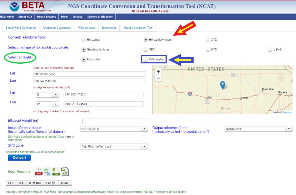
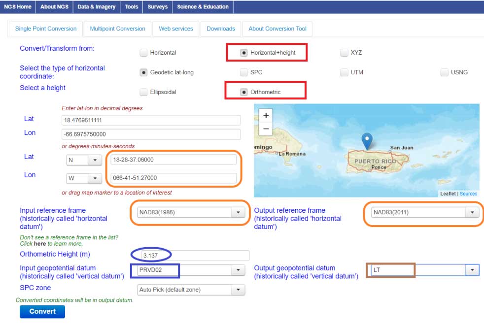
What this means is that you can convert, at this time, stations located in the Conterminous United States and Alaska from NGVD 29 to NAVD 88, and from NAVD 88 to NGVD 29. In order to convert from one orthometric height system to another, you have to click on another button. I’ve highlighted the button in the box titled “Single Point Conversion – Horizontal+height.” Clicking on the button “Horizontal+height” initiates another set of buttons under the section titled “select a height.” There are two options ellipsoid or orthometric. The ellipsoid button is the default option. If you want to convert a height from the NGVD 29 datum to the NAVD 88 datum the user needs to select the button titled “orthometric.”
Single Point Conversion – Horizontal+height
Image: National Geodetic Survey
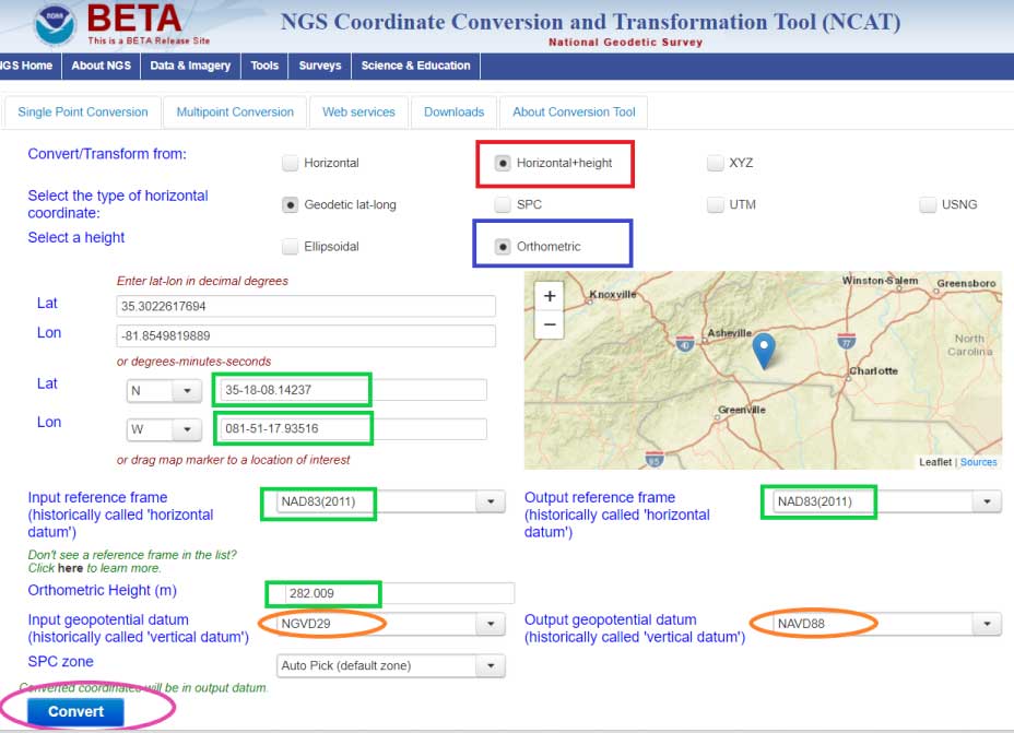
The box titled “Select a Height Option” is a screenshot of the site after the user clicks the “Orthometric height option. The user can now select the input and output vertical datums. The input and output datum options are highlighted in the box.
Select a Height Option
Image: National Geodetic Survey
Once you select the input and output vertical datums, you need to input the latitude and longitude of the station, select the reference frame, and input an orthometric height value to be converted. You must enter an orthometric height that you want to be converted. The box titled “Converting from NGVD 29 to NAVD 88 – Input Parameters” provides an example for station RU 36 (PID FA1337) located in Rutherford County, North Carolina.
Converting from NGVD 29 to NAVD 88 – Input Parameters
Image: National Geodetic Survey
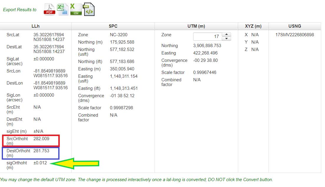
After you enter your input parameters, click on the button titled “Convert.” The box titled “Converting from NGVD 29 to NAVD 88 – Output Solution” provides the output from Beta NCAT tool. The input height and output heights are highlighted in the box. The solution also provides an estimate of the accuracy of the value (SigOrthoht).
Converting from NGVD 29 to NAVD 88 – Output Solution
Image: National Geodetic Survey
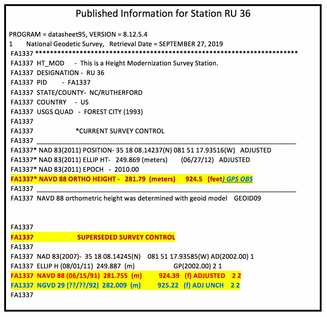
The published information for RU 36 (PID FA1337) is listed in the box titled “Published Information for Station RU 36.” The NGVD 29 height converted to a NAVD 88 orthometric height from the Beta NCAT tool agrees with the superceded NAVD 88 height to within a couple of millimeters (281.753 m minus 281.755 m = -0.002 m). Saying that, the station was superseded with a GNSS-derived orthometric height and the difference is a little larger, 281.79 m minus 281.753 m = 0.037 meters. I’m not saying that there’s anything wrong with the conversion model, I’m only highlighting that, in this case, it agrees with the NAVD 88 leveling-derived heights even though that station has been superceded by a GNSS-derived orthometric height. Users should be aware of this.
Published Information for Station RU 36
Data: National Geodetic Survey
Also, it should be noted that the current version of VERTCON is based on published NAVD 88 heights as of a certain date. If a station has been readjusted since VERTCON 3.0 was generated, then the difference between the modeled value and the published value may be different. The actual difference will depend on how much the newly published orthometric height differs from the previously published orthometric height. If a single station’s height changed due to being disturbed by a local phenomenon such as road construction equipment, then the VERTCON value should still be valid.
However, if the heights of several stations in a region changed due to a regional phenomenon such as crustal movement and/or a large adjustment distribution correction due to a regional vertical control network adjustment, then the VERTCON values may not provide the best estimate of the difference between the two datums.
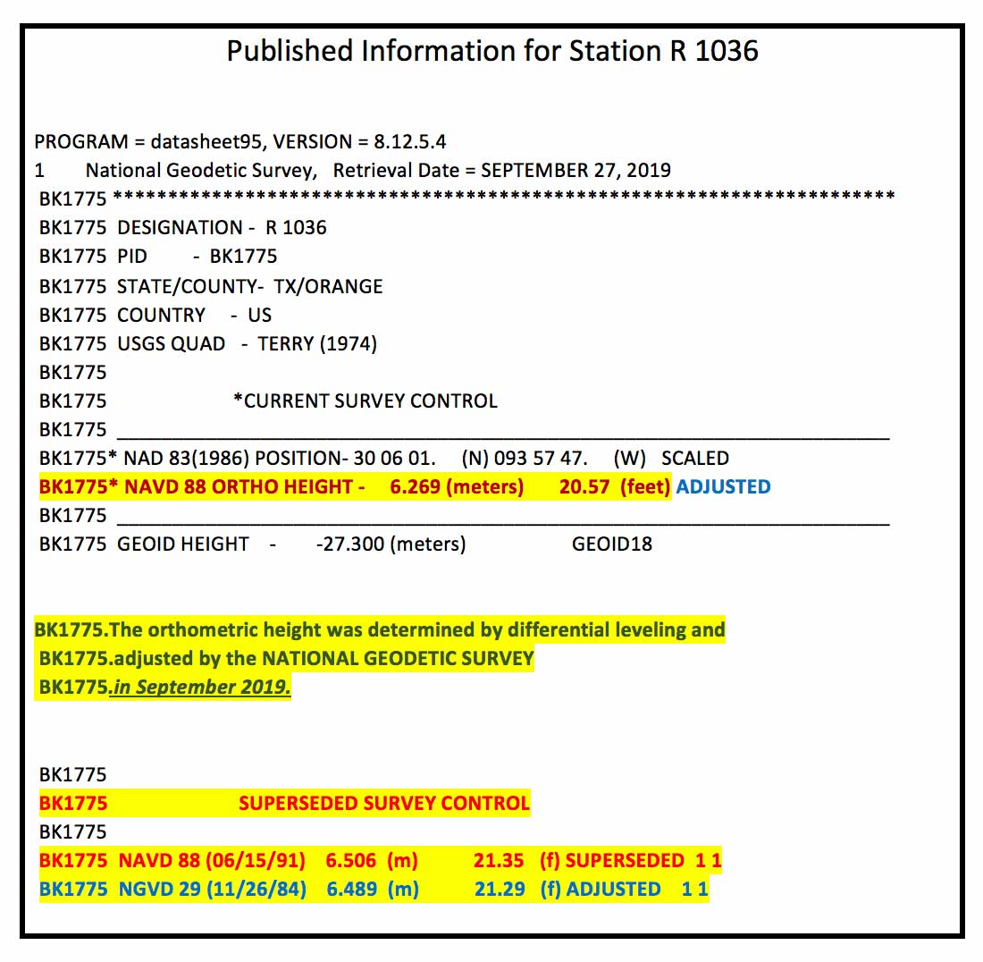
An example of this is provided in the boxes titled “Published Information for Station R 1036” and “Converting from NGVD 29 to NAVD 88 – Output Solution for Station R 1036.” Station R 1036’s NAVD 88 height was updated in September 2019 ,which was after the creation of the VERTCON model. This means that the latest published NAVD 88 height (6.269 m) would not have been used in the model. The newly adjusted NAVD 88 height and the superseded height differ by –23.7 cm (6.269 m – 6.506 m). In this case, this is not an isolated change of a single station’s published height. The adjusted heights of the stations in the region have all changed due to apparent crustal movement and/or a large distribution correction due to a vertical network adjustment.
Published Information for Station R 1036
Data: National Geodetic Survey
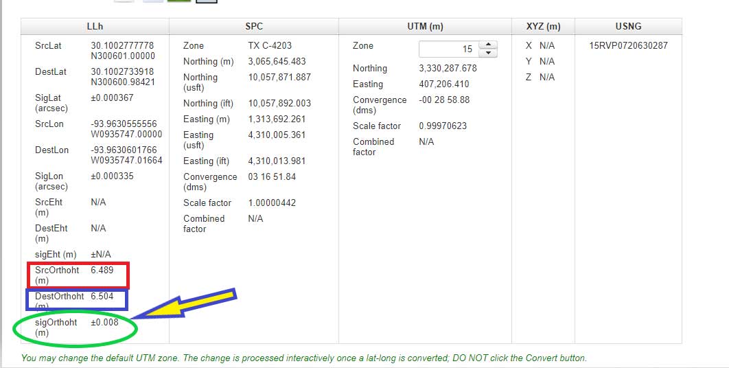
The box titled “Converting from NGVD 29 to NAVD 88 – Output Solution for Station R 1036” provides the converted NAVD 88 height using the NCAT tool. The converted NGVD 29 to NAVD 88 value differs by 23.5 cm (6.504 m minus 6.269 m). Which is expected because the newly published height and superseded height differ by 23.7 cm. It agrees to within 2 mm of the previously published NAVD 88 height (6.506 m minus 6.504 m = 0.002 m). Once again, this is not implying that there is something wrong with the VERTCON model. It’s only to note the limitations of the model. Users need to remember that it is a model and it does not produce geodetic quality coordinate values.
Converting from NGVD 29 to NAVD 88 – Output Solution for Station R 1036
Image: National Geodetic Survey
Users can also convert from other vertical datums published by NGS. These datums include:
Puerto Rico Vertical Datum of 2002 (PRVD 02)
American Samoa Vertical Datum of 2002 (ASVD 02)
Northern Mariana Vertical Datum of 2003 (NMVD 03)
Guam Vertical Datum of 2004 (GUVD 04)
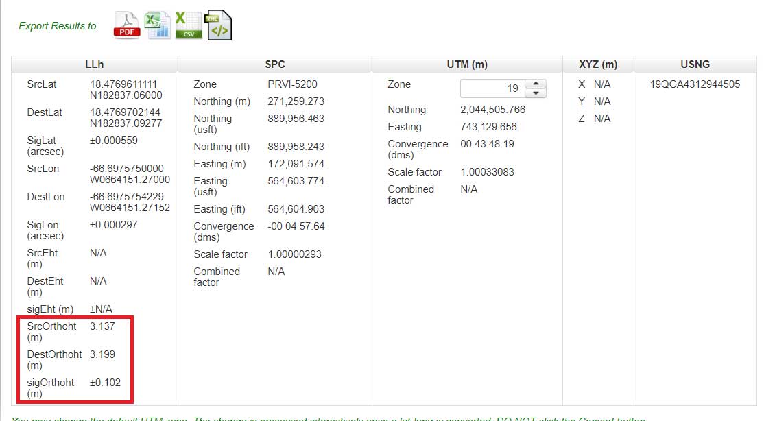
An example of converting a station with a PRVD 02 orthometric height to a Local Tide (LT) value is provided is the boxes titled “Converting from PRVD 02 to Local Tide (LT) – Input Parameters“ and “Converting from PRVD 02 to LT – Output Solution for Station 11 R RESET.”
Converting from PRVD 02 to Local Tide (LT) – Input Parameters
Image: National Geodetic Survey
Converting from PRVD 02 to LT – Output Solution for Station 11 R RESET
Image: National Geodetic Survey
Notice that the difference between the PRVD 02 and converted LT value differ by 0.062 m but the accuracy estimate is +/- 0.102 m.
In my opinion, the VERTCON model and the NCAT tool are extremely helpful tools to the surveying and mapping community. NGS is developing these models and tools to support the implementation of the North American-Pacific Geopotential Datum of 2022 (NAPGD2022). I would encourage all users to download the technical report and perform a couple of conversions in your area of interest.
NGS would like individuals to use the beta products and services and provide feedback. What do you like about the tool and its features? What would you like changed or added to the service? I hope everyone will try the beta version and contact NGS with their comments.
NGS is in a listening mode and wants to develop models and tools to assist users in their transition to the new reference frames in 2022. This is your opportunity to let NGS know what you need (desire) to implement the new reference frames.
The MQ-9B SkyGuardian will participate in NASA-sponsored flight tests in 2020. (Photo: General Atomics Aeronautical Systems)
The defense segment is going from strength to strength — despite a phase not too long ago when defense spending appeared to be dropping. Widespread drone use received a boost with specialized equipment developed for defense forces applications.
The Predator Advances
The General Atomics Predator has gone from a long-distance loiter-and-observe UAV to frontline precision-strike capability, and has been adopted by many military forces around the world.
From first flights in 1994 to initial production in 1997, the Predator has now evolved into many configurations equipped with piston engine, turboprop and jet; line-of-sight radio and satellite command and control; synthetic aperture radar and multi-spectral targeting system; video, TV and thermographic cameras; and laser designators and other payloads.
From pure reconnaissance to various strike and attack configurations, the names have also changed. Predator, Reaper, Gray Eagle, Avenger, Protector, Guardian and SkyGuardian have a host of RQ/MQ designations. For instance, In the RQ-4 Global Hawk name, the “R” means reconnaissance, the “Q” means unmanned aircraft, and the “4” is the series.
The SkyGuardian version of the Predator is a certifiable variant anticipated to ultimately become fully authorized for controlled airspace. It will take part in the NASA Systems Integration and Operationalization (SOI) demonstration program in mid-2020, which will highlight commercial UAS missions using larger drones in the national airspace.
The Predator family has now been evolving for more than 25 years. Unfortunately, the popularity of the Predator family of military unmanned aircraft has led to recent headline news about Predators shot down in the Gulf of Hormuz, or crashed in Afghanistan — such is the price of success!
Global Hawk Gathers Intel
The Northrop Grumman Global Hawk has become a U.S. mainline, high-altitude intelligence gathering asset, deployed by both the U.S. Air Force (RQ-4 Global Hawk) and Navy (MQ-4C Triton). Other friendly nations have also shown various levels of interest in acquiring variants, including Germany, Australia, Canada, Japan and South Korea.
Northrop Grumman has reintroduced the Firebird as a contender in the airborne intelligence, surveillance and reconnaissance (ISR) field. The Firebird can be configured as unmanned (ground control), autonomous or piloted, and has payload flexibility through open architecture, plug-and-play integration.
The North Dakota UAS test range facility at Grand Sky has initiated procurement of two Firebird UAVs, which they intend to supply to their customers for mapping, inspection and monitoring applications using their extensive, long-range BVLOS capabilities.
Skyborg Equipped with AI
And then there’s this U.S. Air Force Skyborg program, which aims to drag the most possible out of artificial intelligence (AI) and automation in an airborne fighter support roll. Kratos has flown the drone hardware a couple of times – the XQ-58A Valkyrie is a “low-cost” unmanned aircraft designed to fly alongside front-line attack aircraft like the F-35 and F-18.
The Air Force Research Laboratory (AFRL) is researching the technology, new sensors, payloads and networking capability these drones will be outfitted with to fly alongside manned fighter jets.
A whole slew of other extremely capable drones are already being operated by the U.S. Army and Navy in a variety of support roles.
Anti-Drone Detection and Prevention
On the flip side, an entirely new related industry segment has come about in the last several years, usually adapting existing radar, sound, infrared or other ground detection systems.
This segment is aimed at circumventing unwelcome drone encroachment over sensitive facilities. Airports, governments, prisons, and energy and water utilities are among the facilities who want to prevent unwanted drones penetrating their airspace.
Solutions may be portable and short range, or ground-based and longer range, with the capability to take down an invading drone or detect where it came from and provide significant warning time.
One solution uses an attack drone that ensnares an intruder-drone in a net and brings it the defender’s location to support second-level investigations. Whatever the solution, drone defense is a growing field.
In a case of fortuitous happenstance, I found myself in an operations support center for an undersea expedition with two, large, flat screens mounted on a wall peering into the deep through the remote viewer slowly gliding through a dark blue barren abyss.
The NOAA ship Okeanos Explorer. (Photo: NOAA)
Deep dive into ocean exploration
That encounter led me on a deep dive of my own into undersea expeditions and becoming this month’s article.
I have been interested the deep sea since my youth growing up in the age of Sealab and watching The Undersea World of Jacques Cousteau. Later in life, I served in the U.S. Navy and took part in one of the first successful real-world tests of a geospatially enabled, full-spectrum battlespace using tactical oceanography, which ultimately steered me into the field of Geographic Information Systems and Imagery Analysis.
That accomplishment helped in my being selected to establish one of the first operational GIS units for supporting Special Operations Forces.
After retiring from the military, I briefly worked as a nautical charts cartographer. So, from a practical perspective, for five years I worked supporting maritime, near-shore and riverine environments. However, going back another 10 years, I was formally trained in oceanography as part of my overall career in the Navy as an aerographer, which also included the disciplines of meteorology, astronomy and astrophysics.
Many years I spent observing and contemplating the ocean of air above, the waters below, and the heavens beyond. One cannot meditate upon the firmaments and assuage the wonder within. Whether for war or love, to ponder the sea and sky emotes an imprint on the heart.
Ocean, the larger part of Earth, alive and thriving, captivates our imagination. What must we, the conscious beast, have wondered when the first of us standing at land’s end looked out upon the mysterious deep of the Great Waters stretching from where he stood to the base of the celestial dome? Did he think it marked the end of the habitable world where mortals dwell and that the great expanse of waters separated us from the heavens where the sun rises and sets and where the moon and stars reside?
I shall reveal a secret; it is a mystery [of the gods] I tell you. There is a plant that grows at the bottom of the ocean, it has a prickle like a thorn, like a rose; it will wound your hands, but if you succeed in taking it, you will hold that which restores lost youth to a man.
— Utnapishtim, Epic of Gilgamesh (Sumeria 2100 BC)
Coral treasures
The Greeks, the race of ancient seafarers knew well the secrets of the sea. Aristotle, the wise philosopher of the ages, still teaches us through his pupil Theophrastus, who spoke of a deep sea plant, red and hard like a stone. He named it korallion. We call it coral.
Photo: NOAA
Aristotle also observed that sponges were better from deeper depths and invented the diving bell to collect them. Another of his students, Alexander of Macedonia, the warrior king, had a diving bell made of glass, a Colimpha, so he could walk the seafloor. Perhaps, on his conquest of Babylon, Alexander heard about the secret of Gilgamesh and sought the plant for himself. How valuable would such a plant be to a warrior king?
Corals have always fascinated man, like treasures from another world — not from this dry land called Earth ruled by air-breathing, upright beings, but from a world of water with bizarre and terrifying creatures and plants made of stone.
Photo: NOAA
Corals, as it turns out, are not a plant at all. They are the smallest of animals, called a cnidarian, and millions of them together form the broad-limbed, rock-like structures. They take many thousands of years to develop into the large, picturesque arrangements beneath the waves.
Colonies of corals form reefs. The largest of these is the Great Barrier Reef in Australia’s northeastern waters. The second largest is the Mesoamerican Barrier Reef in the Caribbean Sea. wherein lies the Great Blue Hole off the coast of Belize. The Great Blue Hole was deeply explored this summer.
Corals are the cornerstone of the ocean. By some estimates, the world’s corals are worth nearly $10 trillion, but that diminishes their real value because if they perish the ocean itself could die. Corals are the proverbial canary in the coalmine, and throughout the world they are ailing.
The ocean’s health is in decline. There have been six severe coral bleaching events in the past 30 years and they are occurring more frequently and for longer periods each time. Over 20% of the world’s corals are already gone. Saving them is a concern for us all.
The United States is leading the effort to protect the ocean’s corals and the National Oceanographic and Atmospheric Administration (NOAA) is at the forefront. The President’s Budget for 2020 funds NOAA for Ocean, Coastal and Great Lakes Research at $218.5M, which is an increase of $12.7M from FY 2018.
A team of scientists and researchers at NOAA are mapping deep sea corals in Alaska and Hawaii and along the coastlines of North America. Operations are underway aboard the Okeanos Explorer, one of NOAA’s ocean exploration vessels. It is on the second leg of Expedition 19-05 taking place from Tuesday, Aug. 27, through Sunday, Sept. 15.
The expedition begins in Canada’s largest underwater canyon, a marine protected area called The Gully 125 nautical miles (NM) off Nova Scotia, and then continuing south along the continental shelf. A deep-sea remotely operated vehicle (ROV), a modern-day Colimpha, is exploring the depths to over 10,000 feet (3,050 meters).
The ship’s location can be tracked online. Clicking on the ship icon will reveal details of the ship’s speed, heading, weather conditions and bathymetry
The Okeanos Explorer tracker allows users to follow the course of an Okeanos cruise. (Screenshot: NOAA)
NOAA’s Deep Sea Coral Research and Technology Program maintains the National Database for Deep-Sea Corals and Sponges, which is an interactive map portal with more than 650,000 records. It can be accessed here.
A Calling for the Ocean
I had the honor and privilege of interviewing Kasey Cantwell, an expedition coordinator for NOAA, after she returned from Halifax helping setup the command center for Expedition Deep Connections 2019 (EX1905).
In June and July of this year, Kasey led the Windows to the Deep Expedition (EX1903) from onboard the Okeanos Explorer, diving into a vast field of deep-sea corals known as the Blake Plateau about 100 miles off the coast of the southeastern U.S. It is one of the largest, most dense and diverse coral fields discovered at those depths.
Control room of the Okeanos. (Photo: NOAA Office of Ocean Exploration and Research)
Kasey’s seven years working at NOAA has been her dream come true. How every mission unfolds is what holds her fascination for the job. As the ROV Deep Discoverer descends, no one knows what they will find, but everyone knows they will be exploring an area never seen before.
They might find a shipwreck, or a plane crash, or a new species, or some strange geological formations. She very much enjoys listening to experts from around the world who are tuned in to the live feed from the ROV, discussing what they are seeing and — even with all that expertise — how often they are all surprised or stumped coming across something unexpected or never before seen.
Better ROVs on the Horizon
Deep-sea exploration is relatively new. Technology continuously improves. The ROV’s ability to remain in place with its high-resolution zoom camera makes exploring and observing the deep-sea environment possible like never before. New discoveries happen with almost every dive.
Limitations exist with the present class of submersibles because they are loud, bulky and bright, scaring off much of the marine life. But the next evolution of deep-sea submersibles are being developed.
The next generation will be stealthy, artificially intelligent, autonomous systems with improved battery life and a suite of sensors able to accomplish much more than we can today. Several of these submersibles will be able to operate in a network, providing us new and fascinating discoveries and observing marine life more naturally.
The best way to stay informed about NOAA’s expeditions is subscribe to NOAA’s Faceook page.
Protecting Our Oceans
America can be proud of its ocean services. NOAA is standing as the vanguard protecting our seas, balancing environmental concerns and commercial demands helping ensure our oceans remain thriving and healthy into the future.
NOAA is identifying areas to be designated as marine protected areas (MPAs) that need safeguarding. There are 15,059 MPAs in the world, and more than 10% are in U.S. waters. MPAs prevent over-fishing and minimize the effects of pollution and further damage to coral reefs and marine environments.
In closing, the biome of the sea has been under explored and undervalued, resulting in less funding, care and attention; but recent discoveries in biotechnology have scientists believing corals hold potential for medicines and life-saving drugs.
Already, more than 40,000 compounds from aquatic resources have been identified for possible medical benefits. This interest is stimulating investment into undersea exploration and development.
In the future, doctors will prescribe pharmaceuticals originating from coral farms on the ocean floor — a secret revealed over 6,000 years ago inscribed on clay tablets in the Epic of Gilgamesh, one of the earliest writings in human history.
The sea summons us to its edge providing a moonlit path by night, and by day a diadem of sparkles herald the sun.
The majestic ocean, rhythmic and soothing yet chaotic and raging, is a tempest that both calms and terrifies the soul. And we, the conscious, land-dwelling beast seeks understanding and harmony with our sister the Sea. That calling is the mission of NOAA’s Ocean Exploration Research.
Strange fluid extrusions found on the escarpment of Verrill Canyon at a depth of 7,972 feet (2,430 meters) on Aug. 30, 2019. (Screenshot: NOAA Okeanos Explorer ROV livestream)
NOTE TO THE READER: In the Epic of Gilgamesh, Utnapishtim preserved mankind from destruction, and as a reward was given eternal life. He was ferried across the “Great Waters” known as Ea, separating the land from the heavens, and sent to live in the city of Dilmun where the Sun rises. Urshanabi, the boatman, was the only one who could pass over the waters between the two worlds. Gilgamesh tricked Urshanabi into taking him in his boat to the edge of Ea to the gates of Dilmun where Utnapishtim came and told Gilgamesh the secret.
As George Bernard Shaw said, “Progress is impossible without change.” Our industry is a great example of that. We have grown from a single GPS service to multiple GNSS constellations, to today’s increasing integration of GNSS solutions with other positioning, navigation and timing (PNT) technologies.
Since its founding 30 years ago, GPS World also has been constantly adapting and advancing so we can better report on, and help shape, our brilliant GNSS/PNT industry.
GPS World now includes expanded coverage of PNT solutions and related integration trends. We also dive deeper into GNSS/PNT developments through Q&As with leading industry suppliers, and we deliver more leading-edge application stories in high demand by our readers.
Other recent changes at GPS World revolve around our editorial staff. This month, we say goodbye to Alan Cameron, our editor-at-large, who served our media brand for 19 years. We wish Alan well.
“Our commitment to delivering timely, accurate, insightful GNSS/PNT intel has never wavered.”
Matteo and Sofranec. (Photos: GPS World)
Please join us in welcoming Diane Sofranec as GPS World’s staff editor. Diane brings with her more than 30 years of experience writing and editing content for business-to-business magazines and digital media. GPS World also is excited to welcome Matteo Luccio as a regular contributing editor.
Luccio possesses almost 20 years of experience as a writer and editor for GNSS and geospatial technology media. Luccio began his career in the industry in 2000, serving as managing editor of GPS World and Galileo’s World, then as editor of Earth Observation Magazine and GIS Monitor. Luccio earned a master’s degree from the Massachusetts Institute of Technology.
In 2020, Luccio will pen GPS World cover stories detailing trends and new solutions in receivers, antennas, simulators and PNT technologies, as well as monthly secondary features on wide-ranging topics.
During the evolution of GPS World over the past 30 years, one thing has remained constant: Our commitment to delivering timely, accurate, insightful GNSS/PNT intel has never wavered. Our stable of staff editors and regular contributors collectively possesses 200 years of GNSS/PNT experience, and our audited audience reach tops 237,000 across all media platforms.
We’re excited to continue to serve you, our family of loyal readers and marketing partners, for decades to come. Together, we remain committed to advancing our knowledge, organizations, profession and world.
The last two U.S. presidential administrations failed to follow through on promises to protect GPS and the nation with a system to backup GPS. A recent Department of Transportation (DOT) appointee is aiming to fix that.
Diana Furchtgott-Roth is deputy assistant secretary of Transportation for Research and Technology. Her office has a broad range of responsibilities including as the federal government lead for civil GPS and PNT issues.
Since Furchtgott-Roth arrived at the department in February, she has been adamant about the need to establish a complementary and backup system that users can access when GPS is not available or signals need reinforcing. She notes that this has been a presidential policy requirement for DOT since 2004.
There are also two Congressional mandates on this issue. The first mandate was in a law passed in 2017. The National Defense Authorization Act tasked the Departments of Defense, Transportation, and Homeland Security to jointly conduct a technology demonstration of GPS backup technology.
Congress funded this project in 2018 through the Defense department, even though DOT was the lead agency. Bureaucratic delays in transferring the funds between departments has meant that, rather than concluding in the summer of 2019 as initially required, the demo is behind schedule by about eight months.
Much of this transpired before Furchtgott-Roth arrived on scene and she is determined to make up for lost time.
A Request for Information (RFI) seeking candidate GPS backup technologies was issued in early May of this year and closed 30 days later. Twenty-two responses were received, though some just offered comments and observations rather than proposing technologies.
Working through the Volpe National Transportation Systems Center, Furchtgott-Roth’s goal is to demonstrate as many of the technologies as possible and conclude the effort by March of next year.
“We want to thoroughly understand all of the proposed technologies, including their ability to penetrate indoors and underground without assistance,” Furchtgott-Roth said.
The department’s procurement website forecasts a Request for Proposals for this effort this month (the site says it will be issued in the fourth quarter of the fiscal year which ends on Sept. 30). The opportunity is described as “Backup Global Positioning System (GPS) Technical Consulting Services for participation in a technology demonstration” with an estimated value of between $700,000 and $2,000,000.
Small businesses that want to be on the notification list for this can do so through the FedBizOpps announcement page.
The second legislative mandate was signed into law in December 2018. The National Timing Resilience and Security Act requires the Department of Transportation to establish a timing system to back up GPS by December 2020.
Among the requirements specified in the Act are that the system must be terrestrial, wireless, have wide area coverage, be difficult to disrupt, and be capable of expansion to provide positioning and navigation services.
Furchtgott-Roth plans to integrate the department’s responses to both taskings as much as possible. “What we learn from the tech demo should very much inform the implementation of the National Timing Resilience and Security Act,” she said.
She also wants everyone on the project to keep in mind that establishment of the timing system is just the first phase of creating a more robust and resilient national PNT architecture. “Timing is important, and we are going to reinforce it first,” she said. “But it is not going to provide resilient positioning and navigation for drones, autonomous vehicles, and all our other transportation needs. America must have a combination of systems available that, when used together, will be very difficult to disrupt.”
To keep things moving quickly, Furchtgott-Roth says she is leaning toward signals provided by a commercial entity, rather than a government-built system.
“The Act suggests we consider a public-private-partnership, and there are a lot of advantages to that,” she said. “The government wouldn’t need to stand up a big acquisition staff or have a large appropriation of funds from Congress. Also, private entities are often able to act faster and be more agile. And they assume most of the project risk.” The aviation safety ADS-B system was created using such a procurement model.
The only snag is that while Congress has appropriated money for the tech demo, it has not yet done so for the mandated operational system. Sources in Congress point out that although the House version of the 2020 budget has $32 million for Air Force “Resilient PNT,” nothing has been allocated for civilian users.
“$32 million would go a long way for DOT’s efforts to protect the 99.9% of GPS users who are not in DoD,” said one congressional staff member. He was hopeful the Senate would designate funds in its version of appropriations for DOT and the issue would be resolved positively in conference.
“GPS has become an invisible utility that so many of our technologies depend upon,” observed Karen Van Dyke, who leads PNT efforts for Furchtgott-Roth’s office. “Providing a complementary and/or backup capability ensures users have PNT even when GPS is disrupted. It may also help protect the signals themselves by deterring malicious actors who might otherwise want to jam or spoof GPS.”
“President Trump’s top priorities are national and economic security. We can’t have GPS signals be a single point of failure for transportation and other critical infrastructure sectors,” Furchtgott-Roth said.
Dana A. Goward is the president of the Resilient Navigation and Timing Foundation.
With the calendar pages turning rapidly and as we get closer to the witching hour of geospatial voodoo, more items have surfaced to discuss and educate ourselves on in relation to “the change.”
Let’s delve into these topics and break each down into what the common surveying and geospatial practitioner will need to know with the advancements in coordinates, geodesy and our everyday uses.
NATRF2022: The continental U.S. replacement for NAD83 and NAVD88
It is no secret that with the advancing use of GNSS technology, flaws in both existing horizontal and vertical datums establishing our National Spatial Reference System (NSRS) have been identified and exposed.
NGS estimates that NAD83 is non-geocentric by over two meters, while the model establishing NAVD88 contains a tilt of approximately one meter across our continent.
For most geospatial practitioners, these flaws are minimal to the integrity of their data. It does, however, give us a glimpse of how assumptions of geodetic information can produce incorrect modeling of surveying and mapping data and could lead to more flawed earth models without significant changes to their structure.
With a great number of surveying and mapping practitioners using GNSS technology with little or no knowledge of the origins of our NSRS, it is a good time to provide the primers below to explain the history of our geodetic datums.
Besides my previous article, follow these links for much more thorough technical information:
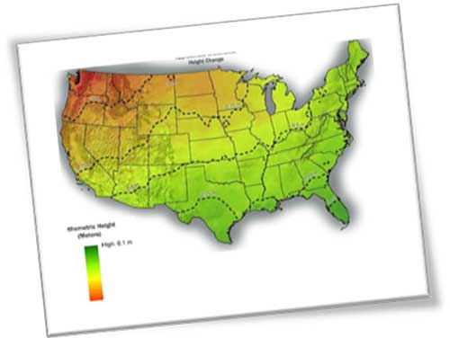
With changes in both horizontal and vertical datums, slight variations in the data we are used to seeing will seem insignificant, but will require the user to pay close attention to potential data traps when converting between the old and new systems. The NGS graphics below depict the severity of datum change in the horizontal and vertical component across the U.S.
Image: NGS
Depending on where you are working, new state plane coordinates will vary from –2 meters to +4.5 meters from previously published values, with elevations fluctuating up to one meter from previous norms. All these changes are due to the increased knowledge of our world using various forms of emerging technology not thought possible several decades ago.
These new measuring methods and studies, including GNSS and gravity monitoring, have allowed scientists and geodesy experts to establish more accurate geographic location systems than past terrestrial ways and procedures.
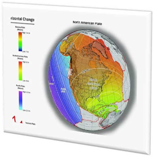
We have geodetic monuments and marks everywhere; will they still be usable?
The short answer to this question is an unequivocal yes, but with some caveats. Use of GNSS monitoring has proven we reside on tectonic plates that move slowly over time; thus, the geographic values (latitude and longitude) used to calculate any number of coordinate value systems are changing as well.
Image: NGS
Relational data between established points are not likely to change, but studies have shown significant shifts in areas that result in movement of our previously considered “unmovable” monuments.
With additional parameters and characteristics being introduced with the 2022 datum, time and tectonic plate shift are main factors in establishment of a point.
The concept of a “permanent” point no longer exists in relation to a published and unchangeable coordinate value of horizontal and vertical data. The surveying and geospatial data collector must recognize that the user is establishing a particular X/Y/Z or N/E/Z value for that exact moment in time and it, theoretically, will change from the moment one steps away from the point.
This may be too “splitting of hairs” for most users, but the new system simply recognizes the reality of the moving data-collection stage, no matter how minute.
This datum re-establishment has been a monumental undertaking (no pun intended), and NGS deserves many kudos for coming up with a realistic solution for a complex problem.
However, most of its users still have a problem, and it lies within the standard unit of measurement: the U.S. survey foot. NGS (and its predecessor, U.S. Coastal and Geodetic Survey) have always used the meter for the basis of all units of measurement (as does the rest of the world.) The new 2022 datum is bringing us, the surveyors and mappers, to a new reality — nationwide adoption of the international foot. Let the grumbling and arguments begin!
The meter vs. international foot vs. US survey foot
The unit of measurement aptly named the “foot” has existed since early times, with most sources crediting King Henry I of England making a decree that his foot shall become the standard for measurement.
No matter where the definition of the foot came from, it has varied slightly throughout history. The origin of the meter (or metre, as it’s known worldwide) also has a variety of beginnings. The most established story starts from John Wilkins, an English philosopher, who published in 1668 what he described as a new standard of measurement based upon the length of a pendulum that swings approximately 38 inches across in one second. This length was eventually named the meter by an Italian scientist.
Another century later, King Louis XVI of France issued a integration law establishing the modern metric system with weights and measures having a base-ten system of units and sub-units. Within this system was the meter with a new length definition of being one ten millionth (1/10,000,000) of the distance from the North Pole to the Equator.
Upon completion of the calculations, a rectangular bar made of platinum and iridium was created to establish the “standard” meter from which all future measurements would be based.
The United States first recognized in 1866 the metric system and the meter (set forth as one meter equaling 39.37 inches). During this time, the International Commission of the Meter officially adopted the physical meter bar as the standard.
Over the next 100+ years, many studies were undertaken to re-establish the length of the meter. Using wavelengths of various elements, including cadmium, mercury, neon, zinc, helium, thallium and krypton, new definitions were created. In 1983, the current definition of the length of the meter was finalized.
The meter is now based upon the speed of light in a vacuum (299,792,458 m/s) with the meter being the length traveled in 1/299,793,458 of a second. While the length is very close to the original measurements set forth over the centuries, it is better defined for reproduction worldwide without having to possess a standard bar or other device.
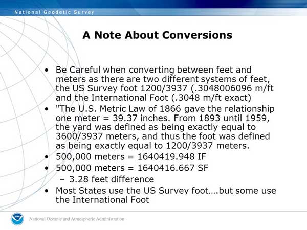
To further muddy the standardization of units, in 1959 an international agreement was made by Australia, Canada, New Zealand, South Africa and the United Kingdom so one yard would equal 0.9144 meters. Meanwhile, the U.S. National Bureau of Standards published a notice that all survey-related measurements will remain based so one one yard equals 3600/3937 meters or 0.91441083 meters.
Image: NGS
We have two different measurements for the foot. What’s the big deal?
The difference between the two standards is two parts in one million; while that doesn’t affect everyday physical measurement, it does cause havoc on coordinate systems with values beyond the millions. (See NGS video “Two Right Feet?” for details).
What makes it even more confusing is that states across our country vary on which “foot” is standard within their legislation and daily practice. Currently (at the date of publication), six states recognize the International Foot as their standard unit of measurement, with four states not defining it. The remaining states have officially adopted the U.S. survey foot as their standard unit of measurement.
NGS has suggested that starting with the 2022 datum change, the U.S. survey foot will not be supported in applications and software produced by them for geodetic computations. It will be limited to meters and the international foot, so they are recommending that states update their existing definitions to change to the international foot along with recognizing the 2022 datum as the official coordinate-system base.
How to train our profession, the construction industry and John Q. Public on the new datum
I would be lying to you if I said I’m not concerned with the rollout of the new datum and with converting all surveying and mapping work to the international foot. My biggest concern is not with those direct relationships I have with my staff and fellow professionals within my company.
My main concern starts with these two areas: the tens of thousands of surveying practitioners working within projects containing state-plane coordinate systems in addition to contractors and other mapmaking providers using survey-grade equipment for construction and other mapping applications.
Both groups have little to no technical knowledge of the intricacies of state-plane coordinate systems and the geodesy network “behind the curtain.” To paraphrase a well-known mortgage company with an app-based home loan system, “push button, get data” is the limit of most users’ knowledge when it comes to state-plane coordinates.
Add to this the double-edged sword of real-time networks, where the user does not have to be concerned with setting up a base station, and the potential problems could get worse.
While there will be a few early and timely embracers of the new datum, the majority will dig their heels in and refuse to switch. When the conversion to the 2022 datum is upon us, many users will drag their feet on learning about the new system as existing projects continue under the old datums.
Until there is a mandate by government agencies and others, many newer projects beginning around the adopting time will remain on NAD83 and NAVD88 until directed otherwise.
Most practitioners I have spoken with on this issue agree that it will be a tricky period for surveying and mapping. Rather than get bogged down with negativity and fight change, the surveying, mapping and geospatial community should do the following:
Rally our professions around these significant changes to educate our technicians and future professionals.
Coach contractors and other trades who rely on the technology to understand the new system.
Work with governmental agencies at all levels to educate them about what these changes entail and why to make the appropriate revisions to codes and statutes now.
Capitalize on this opportunity to teach the public about who we are and how spatial data is part of everyone’s life.
All these points are paramount to the success of the datum upgrade and need to be followed through to the end. Ultimately, the faster we adopt and adapt, the better our geospatial world will be. There is lots of work ahead of us, but as the staff at NGS has shown us, the hard work necessary to make significant change is well worth the effort.
CALLING ALL SURVEYORS AND GEOSPATIAL PROVIDERS!
NGS announces GVX data format for GNSS vector processing
The National Geodetic Survey (NGS) is requesting input and feedback on a new data format for sharing real-time kinematic (RTK) GNSS vector information.
The new format will be like the static GNSS standard, Receiver Independent Exchange (RINEX), and is utilized by most software packages and the Online Positioning User System (OPUS).
The new GNSS Vector Exchange format (GVX), will introduce a new industry standard for sharing of RTK vectors across differing platforms and software packages.
Earlier users of GPS-based data collection remember the number of proprietary files created by each manufacturer, and having their own unique format for data and attribute interpretation. In response, the NGS created RINEX to help standardize data collection as a universal file format that would easily be adopted by receiver and software producers.
That same goal is being set with the introduction of the GVX format as the next step in data-collection standardization for GNSS RTK vectors. GVX elements include (but are not limited to) the following:
A-priori coordinates for the end points of each vector
Receiver and antenna types
RTK and real-time network (RTN) settings, if applicable
Quality control metadata (e.g., PDOP, number of satellites used, orbit type, etc.)
The introduction to the new format along with technical specifications and examples are on the NGS website.
The National Society of Professional Surveyors (NSPS) works directly with NGS to provide input on maintaining and updating the National Spatial Reference System and will include significant assistance with educating geospatial data providers with the upcoming 2022 datum change and implementation of the North American Terrestrial Reference Frame of 2022 (NATRF2022).
The surveying, mapping and geospatial professions have exciting times ahead with these cool upgrades from NGS, so we need to take advantage of the calm before the storm to educate ourselves to make the most of the opportunity.
Geospatial data surrounds all of us, and we are the profession specifically educated for correctly and efficiently keeping a handle on it all. It all starts with growing your knowledge a little bit each day. Please join me in growing the profession as well.
Some ups and downs for unmanned aircraft this month — good news that there is further progress on the pseudo-satellite front, but we also have MIL-SPEC drones lost to shoot-downs and recent crash landings. Amazon continues to advance toward deliveries really soon after orders, and another police department takes up drone use for aerial observation.
High-Altitude Pseudo-Satellite UAS
HAPSMobile (Softbank 95% and AeroVironment 5% JV) is funding further development and testing of the Hawk30 family of high-altitude pseudo-satellite (HAPS) solar-powered unmanned aircraft, with the expectation of long-duration flights above 65,000 feet — “a super cell-tower up in the stratosphere…providing connectivity for everybody that needs it,” according to AeroVironment President and CEO Wahid Nawabi.
HAPSMobile is collaborating with the Pan-Pacific UAS Test Range Complex (PPUTRC), which is managed by the University of Alaska (UA) Fairbanks, and with the University of Hawaii (UH) to conduct stratospheric test flights using the HAWK30 prototype HAPS vehicle. On behalf of this group, UA was recently granted a Certificate of Authorization by the U.S. Federal Aviation Administration (FAA) to fly HAWK30 as a stratospheric telecommunications platform system over the Hawaiian island of Lanai.
The HAPSMobile team will prep test flights at Lanai during 2019, conducting safety verifications and working with island authorities to comply with local regulations. During the program, HAPSMobile will also explore contributions to environmental conservation and to agriculture. Hawaii — not a bad place to run test flights, you might say…
Predator UAV downed
Following the shooting down of a U.S. Global Hawk (really expensive) and one or two Iranian drones (not very expensive) in the Gulf of Hormuz, U.S. forces on Aug. 13 just crash-landed an MQ-1C Grey Eagle (Predator UAV family) southwest of Baghdad on farmland in the town of Radwaniyah. The following pictures were released by a local news group:
The aircraft doesn’t appear to be too badly damaged, and seems to have been deliberately brought to rest in soft undergrowth on the edge of a field. So crash-landing might be an overstatement — rather an unplanned landing, perhaps? Then again, the landing gear appears to be significantly bent out of shape, so the U.S. Army 52178 drone’s contact with the ground might have been heavier than normal.
The news source indicated that the drone might have been brought down by “electronic interference or have been intercepted by a cyber-attack.” perhaps references to potential jamming of some kind? Nevertheless, the aircraft landed safely and was then recovered by Iraqi Security Forces. There were no injuries or damage to property.
The U.S. Army MQ-1C Gray Eagle provides both combat and intelligence forces with a long-endurance, armed, unmanned aircraft system (UAS) with significant range, altitude and payload flexibility.
And another report hit the internet today that back in June, a £6 million U.K. Watchkeeper WK050 drone on a training flight met a somewhat messy end after overshooting its landing and coming to rest in a tree. But the report also mentions that there was some indication of possible operator error.
Amazon Drone Deliveries?
Fresh on the heels of Fed Ex deciding to dump Amazon as a customer because they would appear to be developing a competing delivery infrastructure, Amazon is proposing a semi-autonomous drone that could automate short-distance deliveries.
In a recent letter to the FAA, Amazon is proposing trials in “sparsely populated” regions of the U.S. using its latest 88lb MK-27 Prime Air delivery drone. The UAV apparently has well-developed sense-and-avoid for the flight phase and uses optical capability for the delivery phase.
If obstacles were to be detected in flight (other UAVs, low-flying manned aircraft, helicopters or birds) the MK-27 would avoid and fly round each obstacle. If an obstacle were detected during delivery (maybe the customer waving frantically to stay out of the cabbage patch) the delivery may be aborted and the drone would return to base. But would it automatically dispense one of those “We-called-while-you-were-out” postcards, fluttering down into the backyard so you could go pick up your package later?
Seriously, though… The initial trials would be managed by an operator who can command a return to base if the drone gets into any trouble, but Amazon claims that the fail-safe autonomy built into the MK-27 will make this unlikely. The hardware and software have gone through extensive simulated testing, and the drone has already completed more than 10,000 simulated delivery flights into representative backyards.
Amazon’s objective seems to be to eventually deliver packages within 30 minutes after the customer places an order — to Prime customers within ~8.5 miles from an Amazon fulfillment center.
Growing Police Use of Drones
The Oneida County, New York, Sheriff’s Office just announced that it is are now drone-trained and drone-equipped — with five certificated operators and a fleet of eight DJI Mavic drones for indoor and outdoor use.
The DJI drones will not be modified and will be used as is. The Mavic 2 drones will provide all manner of aerial surveillance including flood and disaster monitoring. In addition, active shooter investigations and the like could involve initial indoor surveillance using Mavic Air drone(s) to provide armed police with situational awareness before any take-down efforts. Accident investigations, location of missing persons, house fires, and rescue efforts are other applications for the drones.
The Sherriff’s department has been preparing for drone use for two years — five officers have already completed FAA-certified drone training, and others are expected to undertake training over time.
Summary
We have potential stratospheric “cell towers” being tested over Hawaii, landing accidents, preparations for potential rapid deliveries by Amazon drones, and another police department launching a drone unit. These are some of the expanding uses for drones, and the unfortunate reality that drones can sometimes get into operational difficulties.
The Geospatial Management Office (GMO) is the designated coordinator of geospatial activities throughout the core of the Department of Homeland Security headquarters and its component agencies.
Part I described how and why the GMO was formed and some of the early activities when resources were limited and expectations were low. Following the devastation along the Gulf States from Hurricane Katrina, the efforts to coordinate and empower the GMO gained focus and energy.
Image: USDHS
Needed: Better coordination
The magnitude of devastation caused by Hurricane Katrina, the uneven response and the inability for all levels of government to act in a unified manner prominently showed the gaping hole in the nation’s geospatial coordination mechanisms. The irony in this lack of coordinated government action, and the blame placed on President Bush’s administration, was that the lack of a geographic framework had been identified as a vulnerability since the late 1800s following the Civil War and never fully addressed.
A patchwork of Executive Orders and other stop-gap actions were in place, but action was needed by the Legislative Branch to finally address this, and, as is too often the case, it took a major disaster to cut through the politics and make this happen, resulting in the Geospatial Data Act. For a more in depth analysis of the Geospatial Data Act read the November 2018 Geospatial Solutions article “Geospatial Data Act Will Bring Huge Changes to America and the World.”
Hurricane Katrina had a sobering influence on federal agencies, providing renewed focus to find new ways to share information, and communicate openly and effectively using a common standard and language.
Dan Cotter, director of the GMO from 2005 through 2007, understood this challenge. Following his predecessor, Ryan Cast (the first director of the GMO), Cotter furthered the relationship with the Federal Geographic Data Committee (FGDC), establishing a Homeland Security Working Group with several sub-groups to advance DHS’s mission. Heavy lifting began on the symbol standards, data model and the U.S. National Grid (USNG).
This collaborative effort was furthered when the GMO secured funding for the first agency-wide enterprise license agreement (ELA) with Esri for GIS applications, training and services. The ELA reduced the cost and administrative difficulties surrounding procurement of GIS software. This dramatically increased the number of GIS practitioners seeking to partner with DHS, FEMA and the GMO.
Cotter was tapped to be the DHS chief technological officer in March 2007, passing leadership to Jeff Booth, who advanced the portfolio and led significant efforts to optimize the geospatial toolset of DHS while migrating it into the federal data-center environment.
Establishing a culture of trust does not come easy in bureaucracies, and this was no different for DHS. Being a relatively new agency, agility and eagerness were key traits, especially with a very fast-paced and high-stakes environment. People would volunteer to take on requested tasks, but that blurred the lines of responsibility.
The launch of GeoCONOPS
The HSE GeoCONOPS is a strategic roadmap to understand and improve the coordination of geospatial activities across the entire spectrum of the Nation. Updated on July 22, 2019, (Graphic: GeoPlatform.gov)
The FGDC and other working groups helped make introductions for the DHS GMO, which furthered the need to clarify each department’s role in the bigger geospatial picture. Defining these various operational roles and responsibilities led to the creation of the Geospatial Concept of Operations, or GeoCONOPS.
GeoCONOPS was a multi-year initiative, and is a playbook for a range of disaster-related events. Though initially limited to the disaster response and FEMA’s mission, GeoCONOPS was a structured community effort to clarify the types and timing of critical geospatial data and analysis needed in a disaster and continues to grow to address other DHS mission areas.
GeoCONOPS was initially published annually as a book, but changes were made too often and it is now only maintained as a website. GeoCONOPS describes the use of geospatial technology in the five mission areas of DHS:
Prevent
Protect
Mitigate
Respond
Recover
It also contains a curated inventory of geospatial resources available to the homeland security enterprise. The final version of the book (v.6, 2015) is available for download. Though often seen as a product, it is likely that the process behind the GeoCONOPS development was of equal or more value as it helped to define the lanes and build much-needed trust among the federal geospatial actors.
Cover of HSE GeoCONOPS resource book, v.4. (Image: Geoplatform.gov)
Through this effective collaboration model, the GMO benefitted from other significant advances elsewhere in the agency and the broader geospatial community. The development of the Homeland Security Information Network (HSIN) delivered value as a portal for the exchange of information and geospatial products on a common operating network among DHS member partners. If there is a major event taking place, such as political conventions, the Super Bowl, or the Boston Marathon, HSIN is sure to be part of the event’s command and control.
Its value was further proven by leveraging HSIN’s user-authentication capability, providing a trusted access-control mechanism for HSIN and other web-hosted geospatial capabilities. These access controls greatly reduced the deployment burden on the Geospatial Information Infrastructure (GII), which is an on-premises version of Esri’s ArcGIS Online suite.
The GII allows for trusted partners to gain access to hosted data, create working groups, and develop and share maps and geospatial applications. The GII also provides access to customized Common Operational Picture (COP) applications providing geospatial situational awareness for a number of operational partners.
These COPs are a result of their own evolutionary pathway, leveraging technology developed by and for the National Geospatial-Intelligence Agency (Palenterra) and through a first-generation viewer called the Infrastructure Critical Asset Viewer (iCAV). Now, with the tools in the GII, highly customized COPs and dashboards are developed for specific events and incidents and shared on an as-needed basis with the full range of stakeholders.
Where NGA and DHS intersect
DHS’s development of a national geospatial dataset put NGA and DHS on intersecting paths. The National Geospatial-Intelligence Agency (NGA) only focused on foreign threats and supporting the warfighter, but after the attacks of September 11, 2001, homeland defense was added to its mission.
NGA’s proven success internationally allowed it to quickly focus on acquiring and developing the best available sources of data. This conventional mission for NGA led to the formation of a new stakeholder group; hence, the creation of the Homeland Foundation Level Data (HIFLD) committee, which developed the first national dataset designed for homeland security and critical infrastructure protection, the Homeland Security Infrastructure Program (HSIP).
Having been initiated in the intelligence community, HSIP’s distribution was strictly limited, which inhibited its adoption across the mission space. To broaden its use, plans were developed to migrate all or much of the program to DHS and to shift the burden of restriction from the need-to-justify sharing to the need-to-justify restricting. With this new emphasis on sharing and openness, HSIP evolved to the current HIFLD Open and HIFLD Secure versions.
The GMO solidified its mission and purpose with the elements of community, transparency, security, technology and data falling into place. Through the leadership of the former GMO directors, the foundation they laid established the GMO as a respected and strong advocate throughout the agency and its partners, from local governments up to the federal level, becoming known as the Homeland Security Enterprise (HSE).
The HSE established a very real link extending from the on-scene first responder to the White House. By the time David Alexander, Ph.D., passed the baton to David Lilley in 2016, the GMO could deliver on its promises and was ready to expand outward. Lilley focused on realigning efforts to match DHS’s policy supporting National Special Security Events (NSSE) and community outreach through its network of 78 fusion centers.
Shortly after Lilley departed DHS, Hurricane Harvey’s torrential downpours and historic deluge began. Acting Director Michael Donnelly agreed to an innovative HIFLD solution to support FEMA operations to help mitigate the flood of data and requests that typically accompanies events of this magnitude.
Hurricane Harvey was Donnelly’s initiation. Following this and storms that followed, Donnelly focused on steadily maturing the GMO through deliberate outreach efforts and strengthening partnerships, building on outreach to regional fusion centers and non-traditional mission areas such as cybersecurity.
While not typically an operational player, the DHS Geospatial Management Office has become a trusted partner to those on the front lines, providing expertise, data, insights and architecture. The GMO is a foundational resource for operators, elevating their capabilities as a force multiplier.
While we can only hope against another cataclysmic natural disaster or major attack, when one does occur, the nation’s geospatial community is better prepared to respond to and recover from whatever comes.
As the saying goes, the better one strives to become, the greater becomes one’s enemies; so, as threats continue to evolve, our investments into geospatial technologies and critical infrastructure will pay dividends now and in the future helping to secure America’s safety here and abroad.
Remember, next time you are watching a large, national level sports game or a big storm approaching, know that others are watching, too. Behind the scenes another game is being played — one with much higher stakes. The players, you’ll not see, and the names, you’ll never know, but safety is their mission and GIS one of their primary tools.
Nate Smith — co-author and main contributor because of his work with the GMO — gave the following presentation to GeoDC, Washington, D.C.’s, geospatial community of interest on GeoCONOPS.
Epilogue
An inspiration for this article was to recognize the DHS GMO and its partners for their growth and utility as demonstrated during Hurricane Harvey, on the assumption that it was not otherwise acknowledged by the community. Well, awkwardly, in between this two-part drama, recognition did come from the Federal Geographic Data Committee in the form of the 2018 Doug D. Nebert National Spatial Data Infrastructure (NSDI) Champion of the Year Award.
Nate Smith has worked at the confluence of geospatial information and disaster management in both the domestic (U.S.) and international domains since 1992. He has been an innovator and pioneer in this discipline through his work supporting USAID’s Office of Foreign Disaster Assistance, FEMA’s GIS Solutions Branch and the DHS Geospatial Management Office.
He refined his knowledge of requirements through work as an emergency first responder and international humanitarian, and has shared his knowledge and experience through courses delivered at a number of Universities. His background includes deployments to disaster locations around the world in support of operations and coordination efforts for events ranging from insect infestation to conflicts.
He is currently an independent consultant affiliated with the Florida International University Extreme Events Institute and FIU’s Academy for International Disaster Preparedness. He earned a BA in Geography from UMBC and a Masters in Urban and Regional Planning from Virginia Tech.