Law enforcement agencies have been quick to adopt GPS monitoring of offenders on parole or awaiting trial. An estimated 300,000 people in the U.S. are wearing ankle bracelets. Proponents say the systems enhance public safety, reduce prison costs and provide social benefits.
However, technology is only as good as the people who use it, as a tragic case from Ohio illustrates. In February 2017, 21-year-old Reagan Tokes was kidnapped and murdered after leaving work in Columbus. The man convicted of killing her had been recently released from prison. Yes, he was wearing a GPS monitor, but no one was tracking his movements until after he robbed six people and killed Tokes.
In response, Ohio lawmakers introduced a bill to improve real-time monitoring of parolees by shrinking the workload for parole officers, who now are responsible for 90 to 100 offenders at one time.
In cases in Florida and New York, the system worked as intended and alerts were sent, but authorities took no action. In the Florida case, no one was on duty, despite the suspect having triggered more than 100 alarms.
An offender in Syracuse, New York, was able to remove and reassemble his ankle bracelet in less than a minute, using techniques he learned when he watched the officers put the bracelet on him. Because of numerous false alarms, the monitoring company had set a five-minute limit before officers were notified, at the police department’s request. Having beat the monitoring system, the offender committed a murder.
A nationwide investigation by ABC’s “20/20” news magazine program found at least 50 murders allegedly committed since 2012 by people ordered to wear monitored ankle bracelets.
“Public safety is only as good as the supervising entity we provide our products to,” Jennifer White of monitoring company BI Analytics commented on “20/20.” Criminal justice experts say the monitoring system should not be used for anyone who is a risk to the public.
While policymakers and law-enforcement authorities determine the most effective use of such systems —and how to address issues of monitoring response, overtaxed officers and tight budgets — the monitoring industry continues to improve the “tamper-resistant” devices as well as the services offered.
After all, no one wants to live with a false sense of security.
A new investigative report by the Russian independent media group “The Project” into luxury dachas owned by high-ranking government officials revealed that most all include GNSS jammers among their amenities. Attempts by the journalists to photograph the dachas from the air using drones were routinely foiled by jamming.
Most all nations’ military and security services have equipment that can block GPS and other satellite navigation signals over areas both large and small. Russia, though, has advanced this to a fine art which it regularly demonstrates.
Russian forces always been proud of their electronic warfare capabilities. They see them as an essential counter to the effectiveness of western high-tech weapons. The news outlet “Sputnik” reported in 2015 Russian military claims that their ability in electronic warfare “makes aircraft carriers useless.”
GPS is an underlying technology for many western weapons, and for much of the west’s critical networked infrastructure. As a result, jamming and spoofing GPS and other GNSS has long been a priority for Russian forces.
In 1997 a Russian company offered a handheld four-watt GPS and GLONASS jammer that was effective at ranges of up to 150 to 200 kilometers. They also reported working with the Russian military on directional antennas for this jammer. These antennas would focus the disruption on a particular target while leaving most other users unaffected. The U.S. Army was sufficiently interested that, in 2002, they reportedly spent almost $200,000 to purchase the jammers for testing and evaluations.
In 2016 Russia announced a program to add GPS jammers to more than 250,000 cell towers as a partial defense against a U.S. cruise missile attack.
That same year a Moscow Times headline proclaimed, “Kremlin Eats GPS for Breakfast!” GPS users near the Kremlin had been regularly finding their cell phones reporting that they were 20 kilometers away at an international airport. This was playing havoc with Uber and Lyft drivers, as well as delivery services that depended upon satellite navigation. This spoofing, or sending false information to receivers, was reported to be an effort to protect the Kremlin and leaders from attack and surveillance by drones. Most drones are programmed at the factory with the locations of airports and to fly away from them. Convincing receivers near the Kremlin or elsewhere that they are really near an airport helps keep the area drone-free.
Independent technologists in Moscow also reported that this spoofing employed a classic electronic warfare technique called “herding.” GPS L2 and L5 signals and Russia’s GLONASS satellite navigation signals were jammed. This forced receivers to rely upon the L1 signal which was spoofed.
That same year this same kind of activity was also detected in the Black Sea. The RNT Foundation reported that over 600 ships had been “transported” to airport locations ashore. A subsequent report in 2019 by the non-profit group C4ADS revealed almost 10,000 instances of ships being spoofed in the Black Sea, the Baltic and in Russia’s west near Vladivostok between 2016 and 2018. It also drew a strong correlation between the movements of Russian President Vladimir Putin and the spoofing events.
Russian jamming and spoofing has not been limited to its homeland. Vehicles, ships and aircraft in other nations, as well as in international waters and airspace, have been impacted. This despite Russia’s treaty obligations under the International Telecommunications Union radio regulations which provide that “All transmissions with false or misleading identification are prohibited.”
The C4ADS report documented a massive Russian “smart jammer” operating almost continuously in Syria that had impact far beyond that nation’s borders. Smart jammers, by their definition, transmit messages that seem to be valid GPS signals, but with content that does not allow receivers to calculate a location. The operation in Syria has caused multiple warnings by the U.S. Maritime Administration of GPS disruptions in nearby international waters, and the European air traffic agency issuing warnings for international airspace in the eastern Mediterranean.
The Baltic and Scandinavia have also seen Russian GPS jamming in recent years. In 2017 the Secretary General of NATO complained about Russian naval jamming that also degraded cell phone service in Latvia, Norway and Sweden.
Early this year Norway protested Russian jamming in its far north, some of which was timed for NATO exercises. Five significant jamming events in the previous 17 months impacted, aviation, construction and other users.
Russia regularly demonstrates that GNSS jamming and spoofing can be a useful tool for internal security and an effective method of power projection. Its actions, along with the portability and proliferation of jamming and spoofing equipment, are undoubtedly meant to remind the west that Russia can take away essential GNSS services at any moment with a just the flip of a switch.
Welcome to Part 2 of our coverage of the mammoth AUVSI Xponential 2019 show in Chicago, which drew 8,000 attendees, featured 300+ speakers on its technical program, and furnished a temporary home for more than 800 exhibitors. It was “Everything Unmanned” and a challenge to cover. Last month we looked primarily at new vehicles. This month’s column focuses on sensors, capabilities and apps aboard those and other airborne drones — and even an anti-drone drone!
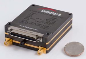
Sagetech: For UAVs to gain entry to the US National Airspace System (NAS) and to other controlled airspace all around the world, sense-and-avoid capability is paramount. Sagetech comes from the world of Mode-S transponders, with which the majority of piloted aircraft are equipped. These devices transmit aircraft identification and provide the moving IDs on air-traffic controller display monitors. In the military sector, Identification Friend or Foe (IFF) interrogator-transponders enable similarly equipped aircraft of NATO countries to determine which are friendly aircraft within their immediate airspace, and which are not.
The MX12B Mode 5 IFF with FAA-certified civil modes. (Photo: Sagetech)
Sagetech has just released a micro-mode 5 MX12B aviation transponder that enables small unmanned aircraft to interoperate within NATO airborne units. The transponders weigh around 10lb, so mil-spec UAVs operating in NATO airspace can now also carry this light-weight unit.
For civilian UAVs, GPS has been added to provide aircraft position outputs in Automatic Dependent Surveillance Broadcast (ADS–B) message format, allowing other aircraft and UAVs to receive a vehicle’s location. The Sagetech ADS-B transponder is small, certified to Federal Aviation Administration (FAA) standards (TSO C-166b) and is affordable. Boeing Scan-Eagle UAVs apparently already carry Sagetech transponder capability.
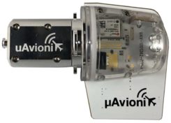
The tailBeacon ADS-B retrofit. (Photo: uAvionics)
uAvionix: Another avionics supplier has brought out certified ADS-B capable transponders, but with a novel way to add the required capability to general aviation (GA) aircraft, typically smaller private planes. The FAA has mandated that all aircraft should be fitted with ADS-B capability by January 1, 2020 in order to fly within controlled airspace, so uAvionix has simplified ADS-B retrofit for older GA aircraft.
All aircraft have wingtip and/or rear-tail beacon lights; this update replaces their existing beacon with a light which also includes ADS-B capability when paired with the aircraft transponder.
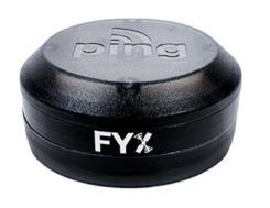
The FYXnav TSO CERTIFIED GPS navigation source. (Photo: uAvionics)
uAvionix also supplies a couple of GPS sensors for external mounting on UAVs: the FYXnav sensor is FAA-certified to TSO-C199 Traffic Awareness Beacon System Class B.
Sensefly released a new inspection application for their eBeeX UAV, specifically designed for solar farms. With a dual thermal/video sensor for data collection and data processing using application-specific Raptor Maps software, Sensefly claims to reduce the inspection time required for a 150MW solar farm to around 1 day, a 300-times improvement on ground inspection using a hand-held thermographic sensor.
Provided an inspection operation could support five 70-minute eBee-X flights during one day, the UAV could over-fly up to 161 acres of solar panels at an altitude of 138ft, gathering anomalies during each flight. This adds up to 150MW of solar panels over the 5 flights. Sensefly claims this to be twice as fast as with multi-rotor dones. The Raptor Maps software then generates an inspection report identifying each anomaly, using the eBee X’s video and thermal imagery to identify, classify, and localize the detected problems.
The Fortem DroneHunter intercept drone. (Photo: Fortem)
Fortem makes an anti-drone defense combining a radar detection system with a DroneHunter drone that attacks other UAVs, releasing an 80ft net to capture intruders. For those nefarious drones which are hardened against RF countermeasures, this system is also touted as capable of recovering the offending drone without damage, returning it to the operator in a net at the end of a tether. The DroneHunter flies autonomously on its intercept mission, carrying a compact radar system integrated with a ballistic net release system.
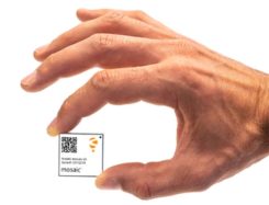
Septentrio continued promotion of its Mosaic chip-level GNSS at Xponential. The new chip uses the same proven core DSP with a new RF front-end and a new processor, working with more than 30 signals from the existing six GNSS constellations, and with L-band and satellite-based augmentation systems (SBAS).
The chip appears to be aimed at the high-precision market, replacing the AsteRx-m2 board level receiver family.
The chip runs Septentrio RTK algorithms, is quite small (1.29 x 1.29 x 0.15 in), is designed for high-volume surface mount manufacture, and comes with a set of popular interfaces. The chip is sampling now, with production planned for later this year.
NovAtel is growing, opening new offices in the US and needing more local real-estate to fit its headquarters in Calgary, Canada. The company is now part of Hexagon Positioning Intelligence (Hexagon PI), a partial re-branding that includes VERIPOS correction services and recently purchased AutonomousStuff, specializing in ground vehicles. Each organization still operates individually through its own brands. On the NovAtel booth, existing products were presented through a number of new applications, including those of the growing mil-spec products group.
Summary. While AUVSI Xponential was over in early May, the companies who were there have not rested. All are developing new approaches for UAVs and unmanned ground vehicles, sensor systems for even wider applications than seen in Chicago, and all manner of other added capabilities. This business only gets bigger and more innovative.
When I was a kid, two of my hometown’s burger drive-ins attracted the hungry attention of my sister and myself, causing us to hound our parents to take us “out to dinner” upon the slightest pretext. Only one of them, however, boasted a sign claiming “400 million served.”
This was a staggering number to an eight-year-old. I hypothesized that everyone in the world must have consumed several by now — a very good argument for me to have one tonight.
The desire to provoke similar reasoning could form part of the motivation for the China Satellite Navigation Office to announce that sales of BeiDou-based chips have exceeded 80 million. Ran Chengqi, director of the CSNO, delivered the number in a report on the 10th China Satellite Navigation Conference held in Beijing on May 22.
“It would be stretching a point to say that satnav chips are the burgers of the future, but it’s not an exaggeration to assert that they are becoming a commodity on the world market.”
Now, 80 million falls short of 400 million, but that next hurdle is well within reach, considering the size, potential and explosive growth of the Chinese market, to say nothing of others along the Great Belt and Road, a global development area of infrastructure development and investments in 152 countries and organizations in Asia, Europe, Africa and the Middle East.
The BeiDou number pales in comparison to the 3.15 billion units of total GNSS chips that global consumption is expected to hit in 2022. By a reasonable projection, BeiDou-enabled chips will by then constitute a major if not the lion’s share of that number.
Of course, GPS-enabled chips will form a greater majority, if not the totality. All chips will — unless the world radically changes — be GPS-enabled to start, and then have some combination of other GNSS in addition.
Big Numbers. Ran Chengqi further said that 22-nanometer dual-frequency BeiDou chips are ready for commercial applications.
According to the China Global Television Network, 116 new positioning-capable cellphone models applied to enter the Chinese market in the first quarter of 2019; 82 of them carry BeiDou-enabled chips. The latest government report on the scale of China’s satnav industry anticipates it will reach 400 billion yuan (US$ 57.8 billion) by 2020.
The news agency stated that more than six million vehicles in 36 cities use BeiDou; long-distance operations and precision farming help raise output by 5% while saving 10% of fuel costs; and more than 70,000 fishing vessels employ BeiDou’s short messaging service.
BeiDou’s rapid success in a relatively short term echoes that of GPS and GNSS in general. It would be stretching a point to say that satnav chips are the burgers of the future, but it’s not any exaggeration or distortion to assert that they are becoming — if they have not already become — a commodity on the world market.
By the way, those golden arches have since 1994 stopped counting and updating their published burger tally. All the signs simply say “billions and billions served.”
This column discusses the results of the National Geodetic Survey (NGS) beta hybrid Geoid18 model and the differences between the beta model and the official hybrid geoid model, Geoid12B. It provides examples to explain the symbology of the Beta Geoid18 Web Map. GEOID18 will be the last hybrid geoid model that NGS will create before NAVD 88 is replaced by the North American-Pacific Geopotential Datum of 2022 (NAPGD2022). I encourage users to access, investigate and become familiar with the web map.
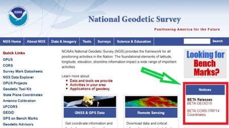
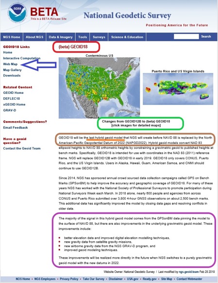
My last column included links to the NGS website that provides the beta coordinates and information about the latest Multi-Year CORS solution (MYCS 2). The column also noted that in late February 2019, NGS released a beta version of the latest hybrid geoid model. See Figure 1, “National Geodetic Survey’s Home Web Page.” This column discusses the Beta Geoid18 Web Map, the results of the hybrid Geoid18 model, and the differences between the beta model and the official hybrid model, Geoid12B.
Figure 1. National Geodetic Survey’s Home Web Page. (Screenshot: National Geodetic Survey)
The Geoid18 hybrid geoid model can be accessed here. See Figure 2, Excerpt from Beta Geoid18 Website. The site provides an opportunity for users to compute a Beta Geoid18 value for a particular station. I would encourage all users to obtain an understanding of the new hybrid model. Once again, it should be noted that this model is a beta model for users to test their workflows and should never be used for official or production work. This allows users to identifies potential issues and differences between Geoid12B and Geoid18, and then contact NGS if they have a question. NGS has done a tremendous job of explaining the Geoid18 process and results, and would appreciate users helping to evaluate the new hybrid model. Several of my previous columns have highlighted the NGS GPS on Bench Marks (GPS on BMs) program and how users have supported the development of the hybrid Geoid18 model: Part 5, Part 6, Part 7, Part 8 and Part 9.
The NGS Beta Geoid18 website provides access to GIS tools that allow users to identify changes between Geoid12B and Geoid18 in their area of interest. The site also states that the hybrid geoid model, Geoid18, will be the last hybrid geoid model that will be created before the new geopotential datum, NAPGD2022, is adopted as the official datum. This is the opportunity for users to be involved in the analysis of the Beta hybrid geoid model. NGS will consider changes to the Beta model until it becomes an official published product. This hybrid geoid model is slightly different from the previous hybrid geoid model, Geoid12B. Similar to Geoid12B, the majority of the design of the hybrid model comes from the relationship between the NGS’ GNSS-derived ellipsoid-derived heights and the leveling- derived orthometric NAVD 88 heights. In other words, the hybrid model is designed to fit to the NAVD 88 orthometric heights.
That said, since the creation of hybrid Geoid12b, there have been improvements in the underlying gravimetric geoid model used in Geoid18. These improvements include:
Better elevation data and improved digital elevation modelling techniques,
New gravity data from satellite gravity missions,
New airborne gravity data from the NGS GRAV-D program, and
Improved geoid modeling techniques.
My previous columns have focused on procedures and routines for establishing GNSS-derived orthometric heights. As I’ve mentioned in these columns, there are many ways to analyze and investigate GNSS data and adjustment results. I have provided basic concepts that I believe are important for users to understand. My October 2016 column focused on the NGS “GPS on BMS (GPSBM)” dataset that was used to create the last hybrid geoid model, Geoid12B.
As mentioned in my October 2015 column, the hybrid geoid model is designed to fit the published NAVD 88 leveling-derived orthometric heights. I highlighted that the GPS on BMs dataset can be used to identify potential issues in the NAVD 88 published orthometric heights. The October 2016 column provided tools and routines that can be used to identify potential issues in NAVD 88 heights and/or NAD83 (2011) published ellipsoid heights. In support of the Beta Geoid18, NGS performed a detailed analysis of the GPS on BMs stations that were used in the creation of Geoid18.
Figure 2. Excerpt from Beta Geoid18 Website. (Image: National Geodetic Survey)
If you click on the “Web Map button” on the Geoid18 web page (see arrow in Figure 2), you may see the statement highlighted in Figure 3. Clicking on the link will redirect you to the correct web site (see Figure 4.).
Figure 3. Result of Clicking on Web Map Button (Screenshot: National Geodetic Survey)
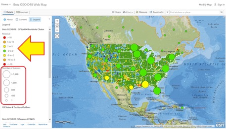
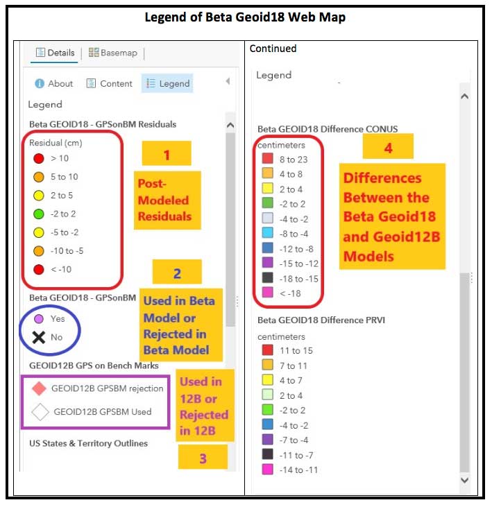
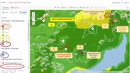
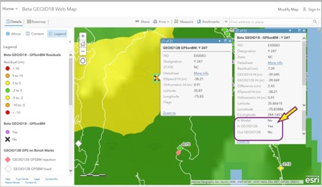
Figure 4. Web Map Option – Results after clicking https://arcg.is/vSn8K (Top Level of Beta Geoid18 Map) [Screenshot: National Geographic, Esri, Garmin, HERE, UNEP-WCMC, USGS, NASA, ESA, METI, NRCAN, GEBCO, NOAA, increment P Corp. | National Oceanic and Atmospheric Administration (NOAA), National Ocean Service (NOS), National Geodetic Survey (NGS)]This data layer provides the value of the post-modeled residuals for all of the GPS on Bench Marks that were part of the evaluation of the Beta GEOID18 model. This Feature Layer is used to populate several layers in the Beta GEOID18 Web Map including the layers called Residuals and GPSonBM. The data for this web map can be found here.The top level of the Beta Geoid18 Map depicts a high-level picture of the residuals. The residuals are in centimeters and represented by different colors. The larger green and yellow circles represent the number of features in the region. The individual GPS on BMs station information appear as the user zooms down. There is a lot of information provided on the Web Map site. The legend changes to provide more detailed information as the user zooms down on the map. I have highlighted four sections on the legend in Figure 5 and provided an explanation of the layers below:
This data layer provides the value of the post-modeled residuals for all of the GPS on Bench Marks that were part of the evaluation of the Beta GEOID18 model. This Feature Layer is used to populate several layers in the Beta GEOID18 Web Map including the layers called Residuals and GPSonBM. The data for this web map can be found here.
This data layer denotes whether the GPS on Bench Mark was used or rejected in the development of the Beta hybrid geoid GEOID18. The data for this web map can be found here.
This data layer denotes whether the GPS on Bench Mark was used or rejected in the development of the hybrid geoid GEOID12B. This has all of the same attributes as the spreadsheet provided on the NGS GEOID12B web page. More information can be found here.
This is a tile package that displays the difference between GEOID18 and GEOID12B in CONUS. It contains two overlayed raster files, one of which is the estimated error and the other is its hill shade. The data for this web map can be found here.
Figure 5. Legend of Beta Geoid18 Web Map (Screenshot: National Geodetic Survey)
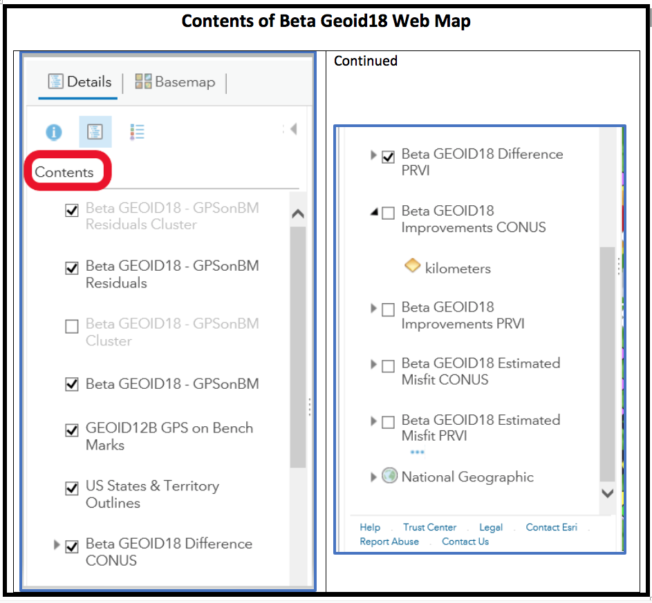
Clicking on the “Content” link provides the data layers (see Figure 6). The user can turn these layers on and off depending on what they’re interested in analyzing.
Figure 6. Contents of Beta Geoid18 Web Map (Screenshot: National Geodetic Survey)
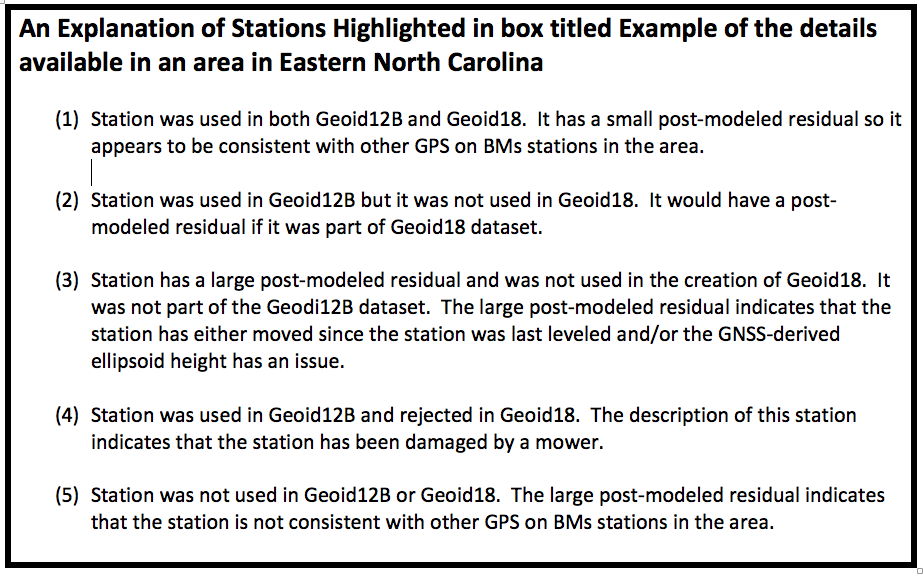
As previously stated, additional details are available as the user zooms into an area of interest (see Figure 7). Five stations have been highlighted in this figure to explain the symbology used on the Web Map site. See Figure 8 for these explanations.
Figure 7. Example of the details available in an area in Eastern North Carolina (Screenshot: National Geodetic Survey)
Figure 8. An Explanation of Stations Highlighted in box titled Example of the details available in an area in Eastern North Carolina (Screenshot: National Geodetic Survey)
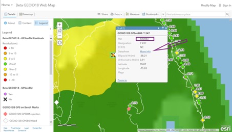
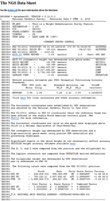
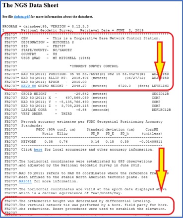
When the user clicks on a station’s icon, another window appears that provides specific information about that station. See Figure 9. If the user clicks on the “More Info” button, the routine retrieves the NGS datasheet from the NGSIDB (see Figure 10). As the NGS datasheet states at the end of the description for station Y 247, the station has been obliterated by a mower, which is why it probably was not used in Geoid18.
Figure 9. Example of Information Available for Individual Stations (Screenshot: National Geodetic Survey)
Figure 10. NGS Datasheet for Station Y 247 (PID EX0083) (Screenshot: National Geodetic Survey)
Figure 11 provides all the information available for station Y 247. It should be noted that the station was used in Geoid12B and not used in Geoid18. This means that there will be differences between Geoid12B and Geoid18 in areas where a station was used in Geoid12B but not used in Geoid18. The amount of the difference will depend on the size of the post-modeled residual. In this example, the post-model residual is 7.39 cm.
Figure 11. Example of Geoid18 Information Available for Station Y 247 (Screenshot: National Geodetic Survey)
GPS on BMs data are usually based on different epochs of data; that is, the leveling data is usually observed at a different epoch than the GNSS data. This means, if the station has moved since the last time it was leveled, then the GNSS-derived ellipsoid height minus the leveling-derived orthometric height will not be equal to the geoid height. The procedure for computing GPS on BMs residuals was described in my February 2018 column. To determine if a bench mark had moved since it was last leveled, the analyst needs several nearby bench marks occupied by GNSS.Users have been very important to the development of Geoid18 by participating in NGS’ GPS on BMs program. These data have been used to improve the reliability of the hybrid geoid model. Users can now help by evaluating areas that have large changes between Geoid12B and Geoid18 (see box titled Figure 12). To help ensure that the appropriate stations were used to create the hybrid geoid model Geoid18, users could occupy nearby stations in the area to evaluate the reliability of the model. This will help NGS improve the reliability of the model in that region.
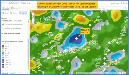
Figure 12. Example of a Large Difference Between Geoid12B and Geoid18 in Western North Carolina (Screenshot: National Geodetic Survey)
I described the NGS’ published height codes in my October 2016 column. In the case of Mitchell 2, there’s no leveling data in NGS’ database in the area surrounding Mitchell 2. There may be leveling projects that have been performed by other agencies such as the USGS but the leveling data have not been processed and loaded into NGS’ database. Users could help by performing GNSS observations on bench marks in the region that are in NGS’ database and/or by performing leveling observations between the GPS on BMs station and the nearest bench mark that has leveling data in NGS’ database.In the example of a large difference between Geoid12B and Geoid18 in Western North Carolina, station Mitchell 2 (PID FB2737) was used in Geoid12B but not used in Geoid18. It wasn’t used in Geoid18 because the NAVD 88 height was not based on an adjustment. According to the description, the leveling tie was performed by a field party that was performing a horizontal survey project (see Figure 13). The field party performed the appropriate leveling procedures but, in this case, the leveling data have not been placed in computer-readable form, so the orthometric height cannot be verified.
Figure 13. NGS Data Sheet for Station Michell 2 (PID FB2737) (Screenshot: National Geodetic Survey)
I encourage users to access the web map and investigate stations that have large post-modeled residuals and/or stations that were used in Geoid12B but were not used in Geoid18. The NGS analyst rejected stations based on pre- and post-modeled residuals but many times there wasn’t enough redundant information available to ensure the station should be rejected or used in the creation of the hybrid geoid model. Users should be commended for their participation in the GPS on BMs program. Hopefully, users will continue their support by evaluating the beta hybrid geoid model.
This year’s AUVSI Xponential show continued to demonstrate how large, thriving and visionary the UAV market is proving itself to be. With attendance around 8,000 people, an extensive technical program featuring more than 300 speakers, and a huge show floor displaying a wide range of sizes, configurations and applications, this was truly 2019’s place to be, see and — for the exhibitors — be seen.
On the large-format side,
an expanding test-range facility in North Dakota brings experimental capability to the oversize crowd,
Bell and Boeing are going full-tilt with large UAVs, both rotor and fixed-wing, and
a higher level market is emerging at 20 kilometers (12 miles, or 65,000 feet) above the Earth.
In the smaller-sized portion of the market, hydrogen fuel cells are extending operational time, and indoor inspections can be significantly cost- and time-reduced with new task-specific models.
Hurricane Irma response. Tuesday morning’s opening keynote featured an overview of how Florida Power and Light (FPL) and Precision Hawk undertook recovery inspections following Hurricane Irma in 2018.
This rang a bell for me, as Irma was the first hurricane I lived through; it passed 30–50 miles to the east of us, up the center of Florida.
FPL flew 4,000 miles with Precision Hawk drones, looking for downed and damaged transmission lines and blown transformers throughout its massive distribution network.
UAVs on the Show Floor
With roughly 800 exhibitors, it’s impossible to see everything, let alone talk with all the companies. So the following is a small subset from the show, with highlights from the large-format UAV sector and a few smaller ones. Further coverage of the show will appear in next month’s newsletter column.
The Bell Nexus demonstrator drew crowds at AUVSI Xponential 2019. (Photo: Tony Murfin)
Bell Helicopter. The Bell Nexus demonstration tilt-rotor – judging solely by the number of smartphone picture takers – was the hit of the show.
Nexus is gleaming blue, with six 8-foot tilt-rotors. The booth had a massive display screen in the back running a loop of its exploits, along with what seemed to be animations of future adventures — flying people around city-center skyscrapers.
Tail-sitter package delivery drone. (Photo: Tony Murfin)
This brings up lots of potential failure modes to be mitigated (six rotors rather than one regular helicopter rotor blade and a complex control system, for instance) for the Federal Aviation Administration (FAA) to chew on during the certification process.
A large four-tail package-carrying sitter drone for larger item deliveries took second place at the Bell booth, even though it is possibly closer to becoming a reality than the gleaming blue star of the show.
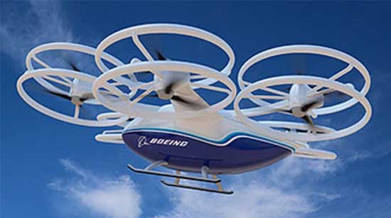
Boeing’s tilt-rotor UAV prototype recently flew its first test flight. (Photo: Boeing)
Boeing. Meanwhile, Boeing was apparently preparing to fly a prototype version of a tilt-rotor UAV, only Boeing’s is designed to be a heavy cargo lifter. The Cargo Air Vehicle prototype vehicle has six tilt-capable dual-rotor systems, weighs 1,100 pounds and is 17.5 x 20 x 5 feet tall. It’s interesting how similar the Bell and Boeing (production concept) configurations seem to be.
Boeing design concept for the Cargo Air Vehicle. (Image: Boeing)
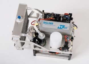
Ballard. Most multi-rotors on UAVs are driven by electric motors, so battery capacity determines the duration of flying time. Ballard has developed the FCair hydrogen fuel cell, which can extend flight time to up to 90 minutes, almost three times that of lithium-ion battery-powered drones.
FCair 600W hydrogen fuel cell. (Photo: Ballard)
Insitu, AeroVironment, Lockheed-Martin, and others have flown the Ballard fuel-cell system; apparently this list also includes the U.S. Naval Research Laboratory and the Air Force.
Grand Sky. The Grand Sky Aviation Park in North Dakota is co-located within the 217 acres Grand Forks Air Force Base (AFB) and has FAA approval as a UAV beyond-visual-line-of-sight (BVLOS) test range.
North Dakota has invested more than $34 million in UAV efforts within the state, with a good chunk going towards the infrastructure at Grand Sky. Now only UAVs fly out of the facility, with Northrop Grumman and General Atomics making it an operational base for Global Hawk, Reaper and Predator drones.
One of the principal benefits is the ability to fly BVLOS operations for large drones at Grand Sky. The system uses two long-range primary radars, one at Grand Forks AFB and the other in Hillsboro, that can detect non-cooperative aircraft.
Harris RangeVue radar and Harris ADS-B sensors coupled with the Air Force’s DASR-11 radar enable BVLOS testing without using a chase plane or staying within line-of-sight. This enables 10–12 hour missions within the 30-mile, 18,000-foot BVLOS range, with continuous electronic monitoring by the ground-based radar system.
A new operational center is being built to house the integrated system and to provide access for visiting drone operators, and the BVLOS range is expected to be ultimately extended all the way to the Canadian border.
Flyability. The Elios 2 UAS system has evolved to include a rotatable thermal and high-definition visual camera payload, 10,000-lumen oblique lighting system, and reversible rotors that enable the UAV to back out of tricky situations.
A geodesic-like cage surrounding the drone makes it collision-tolerant and enables flight in restricted indoor areas such as refinery enclosures, mines, vats, cargo holds and nuclear containment vessels — anywhere, in fact, that inspections today are regularly conducted by people.
A typical nuclear plant inspection might cost $500,000, while this drone system costs around $35,000, and an inspection might take around 10 minutes. For traditional inspections, plants might have to go offline completely while people crawl around in extremely difficult, often dangerous spaces, and manual reports might take significant time to produce.
Flyability claims huge savings in inspection time with their system, as well as automated analysis and production of reports.
AeroVironment. Just before the show, SoftBank, Japan and AeroVironment held a press conference in Japan outlining their HAPSMobile Joint Venture to address the lack of communications access in many parts of the world. Almost 3.7 billion people, or half the world’s population, currently do not have internet access.
SoftBank wants to provide internet inexpensively, without the need for extensive ground infrastructure, by operating high-altitude pseudo-satellite (HAPS) UAVs. HAPS is expected to fly in the stratosphere at a 20-kilometer height for up to six months, powered by solar cells and equipped with payloads that enable direct connection to the internet for users on the ground.
Airborne-type certification and spectrum will be required for the uplink/downlink. Both present significant challenges, but HAPS suppliers, including Airbus, Facebook and others are joining the fight for spectrum. AeroVironment has a $65 million contract from HAPSMobile to develop and produce HAPS UAVs, and build of their Hawk 30 HAPS UAV is well underway.
HAPSMobile has also taken a minority $125 million position with Loon, which has been flying stratospheric balloons for several years, providing wireless coverage in Puerto Rico after Hurricane Irma, and network coverage in South America.
Other suppliers exploring the HAPS market at the show included Airbus, which displayed its Zephyr UAV and recently announced the opening of the Wyndham HAPS launch site in Western Australia; and UAVOS, which announced a new control system for its HAPS vehicle.
In addition, Boeing’s unmanned aircraft subsidiary, Aurora Flight Sciences, has already made significant claims about the capabilities of its own Odysseus HAPS UAV program.
Recapping the Recap. With many more exhibitors and limited time, the rest of the story from Chicago’s 2019 Xponential exhibition will have to wait till next month, to include show news from Sagetech, uAvionics, Sensefly, Fortem, Septentrio, NovAtel and others.
In sum, we see a wide range of different applications all benefiting from unmanned air vehicles of different types and configurations. A number of outfits are working the HAPS gamble, North Dakota’s BVLOS test-range expansion brings experimental capability to the oversize crowd, and Bell and Boeing are going full-tilt with large UAVs, both rotor and fixed-wing.
These developments clearly indicate that the UAS business continues to grow into a huge number of applications and to look very healthy.
In February I had the privilege of addressing the European Space Agency’s (ESA’s) Navigation Days conference in the Netherlands. An internal ESA event, Navigation Days gathers engineering staff from centers in several countries to discuss the present and future of their endeavors.
Since most of the audience had been “bathing” in Galileo, EGNOS and the evolution of both systems for many years, the Director of Navigation and the Galileo Project Manager thought it would be interesting for all to have an “outsider” perspective and opinions on Galileo and the European GNSS position in the world.
Though my half-hour talk ranged freely, and perhaps somewhat wildly, across many sectors and subjects, it had two main foci: the fundamental differences between Galileo and the three other GNSS, and the future portended by those differences. A future column here will address the latter, that is, the future. At present, the present distinctions.
To me, they distill down to three elements: active stimulus of market development, well-funded research into new applications, and — actually the foundation stone of the afore two — democratically elected governments representing citizenry with altruistic values: a strong desire for the common good, thoughtful regulation, intertwined diversity and open borders.
In sum, Galileo’s strength is the strength of the European Union.
“Active stimulus of market development, well-funded research into new applications, and citizenry with altruistic values.”
For example, the Horizon 2020 framework program offers €80 billion to support and foster research from 2014–2020. Three E-GNSS calls in H2020 have a total budget of €100.9 million and they synergize with topics on societal challenges. To my knowledge, the U.S. has nothing like this in terms of downstream R&D programs; it is left to the marketplace to initiate and sustain such efforts.This corresponds to the respective economic systems of the two political entities. West of the Atlantic has historically taken a laissez-faire attitude towards applications, development and societal challenges: let the marketplace act.
The other two GNSS powers, Russia and China, as authoritarian regimes, may build viable GNSS and mandate their use, but the synergy between government and users is lacking. This missing link could prove an economic as well as technical weakness in the future. In some respects, it already has.
Particularly in transportation, freight and liability-critical applications, where the European GNSS have devoted extensive forethought to both user and societal needs (read “the environment”), we may see a distinctly different and more progressive future unfolding in Western Europe, led by Galileo.
On the other hand, in the realm of pure consumer devices, the market may be a stronger driver, and U.S. products and services with a GPS bent may remain dominant.
The Public Regulated Service (PRS) for defense, security, emergencies and critical infrastructure, is the hidden strength of Galileo.
I’ve run out of space here for non-scientific speculations, but will expand them in a future column or online.
How will wireless technologies most significantly drive change and innovation in the surveying industry?
Miguel Amor
“GNSS by design, by physics, will always be challenged in urban settings. 5G and GNSS will provide a step to ubiquitous positioning in built-up areas — a blend of relative and absolute positioning, terrestrial and satellite-based measurements.” Miguel Amor Hexagon Positioning Intelligence
Greg Turetzky
“The improvements in bandwidth and latency of 5G will create new opportunities for edge and cloud-based computing advances such as AI and machine learning to penetrate surveying, as 5G is doing in other industries, to improve efficiency, accuracy and automation.” Greg Turetzky Consultant
Members of the EAB
Tony Agresta Nearmap
Miguel Amor Hexagon Positioning Intelligence
Thibault Bonnevie SBG Systems
Alison Brown NAVSYS Corporation
Ismael Colomina GeoNumerics
Clem Driscoll C.J. Driscoll & Associates
John Fischer Orolia
Ellen Hall Spirent Federal Systems
Jules McNeff Overlook Systems Technologies, Inc.
Terry Moore University of Nottingham
Bradford W. Parkinson Stanford Center for Position, Navigation and Time
On April 10, the world looked in awe at the first image of a black hole. The image was captured by a world-spanning network of radio telescopes that together, using Orolia atomic-clock technology, create the Event Horizon Telescope.
It zeroed in on the supermassive monster — 6.5 billion times the mass of the sun — in Galaxy M87 to create the image.
As Innovation Editor Richard Langley explains, the technique used to capture the image — very long baseline interferometry (VLBI) — relies on GPS. (VLBI was the topic of Langley’s Ph.D. thesis.)
VLBI links two or more radio telescopes that can be many kilometers apart, or even on different continents. VLBI is used in both geodesy and astronomy. There is also a practical GPS link to the Event Horizon Telescope. From the second of six simultaneously published open-access papers on the result: “All timing is locked to a 10-MHz [hydrogen] maser reference and synchronized with a pulse-per-second (PPS) Global Positioning System (GPS) signal…”
“[T]he long-term drift of the maser [is] compared to GPS, measured by differencing [and plotting] the 1 PPS ticks from the maser and local GPS receiver. The vertical width of the trace is due to variable ionospheric and tropospheric delays of the GPS signal, while the long-term trend represents the frequency error of the maser. The drift measured from this plot, and its effects on the fringe visibility, are removed during VLBI correlation.”
Image: Event Horizon Telescope Collaboration
From the third paper: “In order to reconstruct the brightness distribution of an observed source, VLBI requires cross-correlation between the individual signals recorded independently at each station, brought to a common time reference using local atomic clocks paired with the Global Positioning System (GPS) for coarse synchronization.”
U.S. positioning, navigation and timing (PNT) capabilities are vitally important to millions of civilians, as well as U.S. and allied militaries.
The third Navigation Technology Satellite will go beyond GPS III — whose capabilities, mark you, are not yet online — to investigate new experimental antennas, flexible and secure signals, increased automation and use of commercial ground assets.
By Joe Rolli, Harris Corporation
Joe Rolli, Director of Business Development, Space and Intelligence Segment. (Photo: Harris Corporation)
Over the past decade, military leadership and national strategists have shared their concerns about U.S. dependence on GPS for everything from financial transactions to commercial transportation scheduling to precision weapon system guidance.
The new generation of Air Force GPS satellites, which began launching in late 2018, marks a significant step toward improving GPS services with three times greater accuracy and up to eight times improved anti-jamming capabilities over the previous GPS satellite block.
Now the Air Force Research Laboratory and the Space and Missile Systems Center are focusing the Department of Defense’s first experimental Navigation Technology Satellite (NTS) in more than 40 years: on initiatives that will demonstrate new tactics, techniques, and procedures to improve PNT resiliency and counter threats to GPS.
As a unique satellite that flies outside of the GPS constellation, NTS-3 will host experiments with impact across the PNT user spectrum — military, civil, academic and commercial. It will explore innovations in atomic clocks, antennas, reprogrammable digital waveform detectors, signals and other technologies.
Harris, the satellite prime contractor for NTS-3, is approaching these mission innovations from the standpoints of responsiveness and resiliency as well as technology advancement. For example, the design will support the simultaneous broadcast of dual-frequency, regional high power, and Earth coverage signals. An agile waveform platform will demonstrate the ability to rapidly develop and deploy new signal waveforms with total flexibility throughout the satellite life cycle. These innovations will allow operation in multiple contested environments, a key to achieving resiliency that can combat electronic jamming, spoofing and more.
Another strategy is the design of a modular NTS-3 payload that can be reprogrammed in space. Based on open, industry standards and interfaces, the payload will be scalable and can be hosted on diverse platforms and in varied orbits with minimal changes.
When NTS-3 launches for its planned one-year experimental campaign — anticipated to begin in 2022 — it will be the latest in a series of experimental spacecraft that have blazed the trail for the extraordinary technological advances that led to the GPS system we enjoy today
AUVSI Xponential 2019 — the huge exhibition and conference built around unmanned everything — will run at the West Building, McCormick Place Convention Center, April 29 to May 2 in Chicago.
This is the premier show for the Association for Unmanned Vehicle Systems International (AUVSI) group and its many members and supporters who have interest in unmanned technology — 8,500 attendees with connection to unmanned and autonomous capability are expected to walk the exhibit hall to see the latest products, hear numerous related presentations, participate in educational courses, and mingle with other like-minded people in the industry.
I was looking for a way to provide a brief overview of the companies exhibiting; a sample cross-section to provide an insight on what to expect. But with more than 700 exhibitors, it’s a difficult thing to do. Then I realized that the company show preview emails in my inbox were from organizations that were actually quite representative of the industry, and I had my overview selection.
Flyability’s drones are adapted for inspection tasks, both indoors and out, with an exterior protective cage. Routine inspection jobs indoors, underground and around complex pipework become quicker, safer and are fully documented by high-resolution video and stills.
This all enables the reduction of costs and process-interruption downtime of industrial inspections, while also reducing to a large degree the risks for inspection professionals. Industries using these inspection drones include power generation, oil and gas, chemicals, maritime, infrastructures and utilities, and public safety.
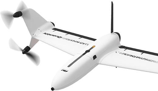
AeroVironment’s drones are used extensively by the military for surveillance and reconnaissance, and in the commercial sector they focus on tools for agriculture.
Quantix drone. (Photo: AeroVironment)
The VTOL (vertical take-off and landing) Quantix drone system is fully automated for takeoff, flight and landing, enabling mapping of farm acreage to monitor crop health to identify anomalies due to water, insect, weed and disease so their impact on yield can be minimized.
Valqari has developed a drone mailbox that is interoperable with a large number of delivery drones and enables drop-off of packages in residential neighborhoods.
The Valqari drone mailbox automatically accepts packages and safely stores them until the recipient opens the box later to retrieve them.
Cepton Technologies makes lidar systems more commonly used for automotive obstacle detection, but now customized for UAV integration and use. Its UAV lidar system provides long-range, high-resolution and low-cost mapping capabilities in a lightweight package. With a scanning range of 200 meters, high-density map-data acquisition becomes possible.
Deseret UAS is a non-profit working to bring UAS business to Utah — the organization offers information, promotes UAS companies and offers test-range access in Utah. In collaboration with Utah State University AggieAir, FAA authority for flight testing in wide open; low-risk operational areas of Utah can be accessed.
And, of course, General Atomics Aeronautical Systems (GA-ASI), manufacturer of the well-known Predator military drone, will exhibit. At Xponential 2018, GA-ASI unveiled its MQ-9B SkyGuardian certifiable drone system. Through the year, the company has progressed towards certification of the system for flight within the U.S. civilian National Airspace System and the civil airspace of other countries around the world.
GA-ASI’s latest media release recounted how an MQ-9B was flown by the company’s Certifiable Ground Control Station (CGCS) on March 9, including both take-off and landing. The CGCS architecture separates flight and mission-critical functions. Off-the-shelf avionics and flight computers are used for flight-critical functions, and mission-critical functions run alongside GA-ASI’s Advanced Cockpit payload and weapons equipment.
Meanwhile, High Altitude Pseudo-Satellite (HAPS) unmanned aircraft are back in the news with what appears to be a crash during the sensitive take-off/climb-out regime. The Airbus Zephyr aircraft — with an 82-foot wingspan, but weighing less than 75 pounds — was engaged in a test campaign in Western Australia when the ground abruptly intervened on March 15.
Airbus is working with the UK Ministry of Defence to demonstrate the operational capabilities of the UAV and its anticipated payload options. Once airborne, Zephyr is intended to climb out to upwards of 65,000 feet into the stratosphere — previously achieving a maximum altitude of 74,000 feet — and has so far been able to remain airborne for almost 26 days. The object is to create a commercial, reusable, reconfigurable satellite-like capability for communications and surveillance applications.
Airbus and MoD are undertaking a crash investigation to determine what exactly happened and how to prevent future recurrence. The incident occurred about four hours into a demonstration flight, and (reading between the lines) may have been related to rapid weather changes that destabilized the UAV while in the take-off and climb-out phase. An automated launch system is in the works — currently Zephyr is man-handled for take-off.
Other HAPS programs include AeroVironment and Japan’s Softbank, Astigan and the UK Ordnance Survey, BAE Systems and Prismatic, and Boeing’s Aurora Flight Sciences. Thales, meanwhile, is apparently focusing on an approach using an autonomous airship.
So some good news, some not so good. Lots of attendees are expected in Chicago for the AUVSI Xponential show, with new developments in unmanned aircraft, robotics, and unmanned ground and water systems anticipated in the exhibition hall. There will be lots of people in the industry with whom to exchange ideas and conduct business to conduct, hopefully just as spring arrives in the windy city.
Meanwhile, over the coming months Airbus will no doubt continue to work out how to overcome the latest problems in HAPS technology and operations.
Portlandia Prediction: Fred Armisen and Carrie Brownstein have a few questions about their chicken dinner. (Screenshot: IFC)
In 2011, the first-ever episode of a TV comedy called “Portlandia” debuted. In one sketch, concerned diners played by series stars Fred Armisen and Carrie Brownstein question their waitress about the origins of their chicken dinner.
The waitress shows the couple the chicken’s papers and photo — Colin the Chicken lived a free-range life on a four-acre woodland farm only 30 miles away, dining on sheep’s milk, soy and hazelnuts, in the company of his chicken friends. Unconvinced even by these details, the couple decides to drive to the farm to see it for themselves.
Enter GoGo Chicken
In a case of comedy becoming reality, Chinese insurance company ZhongAn Online has outfitted more than a 100,000 chickens with GPS trackers. People who buy a chicken with a tracker strapped to its leg will know every step that that chicken has taken. Using a smartphone app called GoGo Chicken, customers can monitor the animal’s diet, exercise and environment.
The company says its technology will be on 2,500 farms in China by next year. It is also working on facial-recognition technology so that consumers can make sure the organic chicken they saw on the farm is the same one that ends up on their plate.
While this all sounds a bit much for many of us who grew up on Chicken McNuggets, there is a practical side. The company hopes GPS tracking will help prevent food safety problems, such as a 2014 crisis in China in which a supplier was caught selling rotting and expired meats to fast-food chains. In the event an issue does arise, the data tracked by the devices could help find the source of the problem.