Category: Opinions

  • Expert Advice: Managing GPS, Take Two

    John Lavrakas
    John Lavrakas

    By John Lavrakas, Advanced Research Corporation

    What a difference eight years can make! My September 2006 GPS World article “Managing the GPS Constellation for Today’s Needs” dealt with GPS performance issues many high-precision users then faced. Demanding applications of real-time precision positioning, such as precision agriculture and machine control, did not find enough satellites in view to support their needs.

    I posed the question: Is the problem with the number of usable GPS satellites, or with growth in the demands of the user community? The 2006 answer was: a little bit of both.

    Now the issue has pretty much gone away. Users have adapted to incorporating other GNSS signals, initially GLONASS and now BeiDou. Russia’s commitment to operate GLONASS at full capacity developed into today’s operation of its 24-satellite constellation. China’s similar declaration led to deployment of 16 satellites to date toward an eventual constellation of 35. Europe is likewise poised to offer global services with Galileo. GPS’s days as the sole provider of ubiquitous, accessible services appear to be over.

    One of my 2006 recommendations was for GPS decision-making authorities to support an aggressive program to replace aging satellites. This has been done. GPS went from one IIR-M satellite in 2006 to the present seven IIR-M satellites and seven IIFs. They provide a new civil signal on L2C, and the IIF provides a new civil safety-of-life signal on L5. 

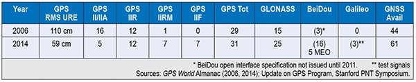
    Let’s look at the differences in service between 2006 and 2014 as shown in Table 1. GPS RMS user range error (URE) has been cut in half, and the number of usable GNSS satellites has gone up by 39 percent (44 to 61). 

    Table 1.  Differences in GPS service between 2006 and 2014.
    Table 1. Differences in GPS service between 2006 and 2014.

    Today GPS and GLONASS operate at full capacity. GPS exceeds its marks by providing 31 satellites broadcasting signal-in-space range errors in the half-meter range, even as Block IIF satellites add L2C and L5 signals. GPS high-precision users also employ space-based augmentation systems services such as WAAS, EGNOS, and QZSS. Internet-connected GPS receivers, including those in cellular phones, use Assisted-GPS to provide near instantaneous times to first fix. 

    One drawback to GNSS is its undependability when subjected to blockage, interference, or spoofing. GNSS services should be made more resilient, and PNT users must diversify their positioning sources. We are now moving into a hybrid world, in which PNT services go far beyond “just GPS” to multi-GNSS services augmented by other PNT technologies, including assisted GNSS, inertial sensors, and terrestrial positioning services. Although diversifying PNT sources increases cost, it may not be as much as some might think. At a recent PNT symposium at Stanford University, Greg Turetzky of Intel predicted even consumer-grade receivers used in automobiles, tablets, and smartphones will embrace all GNSS, despite the added cost in chip size and power. 

    Setting aside the larger PNT discussion and considering only GPS, what challenges must GPS address to remain the cornerstone of PNT services? Here is my list of the top issues GPS faces today.

    Signal Vulnerability. Since the issue of GPS vulnerability was raised in the 2001 Volpe Report, this issue has not changed, but the stakes have risen much higher. There is greater dependence on the GPS service than ever before, with over a billion users. It is generally conceded that for many applications, reliance on GPS in its current form is insufficient and even risky. Brad Parkinson espouses the mantra of protect, toughen, and augment GPS, focusing on steps necessary to strengthen its service.

    Numerous methods are being explored and implemented to protect and toughen GPS: increased signal power on modernized satellites, improved antennas, and authentication of the signal against spoofing. The U.S. Department of Transportation is actively seeking ways to protect GPS spectrum through public workshops on GPS adjacent-band compatibility. 

    The GPS civil signal remains open to malignant spoofing by nefarious forces. Various methods are being proposed to counter this threat. It may seem that adding signal authentication is a bit too late, since civil GPS signals have already been defined in interface specifications, but it turns out this may not be the case. At the Stanford Symposium, Col. Matt Smitham of the GPS Directorate stated that now is a good time to play with the civil navigation message implementations to explore features like authentication. “This is the time to do this, change the message types,” he said. Thus, there is an opportunity to counter this threat. 

    Gaps in Service. A low-power service that has limited operation in many settings, GPS does not provide full functionality at the Poles, nor does it work indoors or underwater. This issue is exacerbated by society’s demands for PNT services anywhere. The 2008 National PNT Architecture identified these gaps as a primary concern, encouraging numerous actions to resolve them. 

    Split Leadership. Although the Space-Based PNT Executive Committee and its National Coordination Office provide a mechanism for establishing high-level policy and providing outreach, they fall short of meeting other essential needs for acquiring, operating, and sustaining GPS. Funding for GPS is split between a number of departments and agencies including the DoD, DOT, the FAA, and NASA. The net effect is prioritization decided by individual departments and agencies, but not by the GPS leadership itself. Thus, some programs get funded by Congress, such as satellite and control system acquisition and the FAA’s NextGen program, but others do not. Civil signal monitoring and complementary PNT services to support increased PNT resilience have not been adequately funded. GPS operations experience the tragedy of the commons: GPS civil signal formats are defined but service standards and management protocols are not. 

    How to Manage GPS for Today

    • Resolve GPS vulnerabilities by strengthening the system and augmenting the service. Take the lead in addressing system vulnerabilities, including mitigating jamming and interference, and installing protections against spoofing. Hold forums on authentication means and methods, and fund research demonstrations using pre-operational civil signals.
    • Work to close the gaps in service. Implement reduced-cost-impact, easily accessible complementary technologies to fill GNSS gaps. Implement civil signal monitoring using alternative networks until the Next-Generation Operational Control System incorporates civil signal monitoring requirements.
    • Establish even closer cooperation between military and civilian leadership to provide unified funding, acquisition, and operations. Ensure a unified message to Congress for multi-agency funding needs. Work together to implement new civil signals, including operational protocols. Set dates cooperatively and meet them.

    The GPS program produced a revolution in ubiquitous positioning, navigation, and timing that cannot be stopped. Care must be taken to ensure its services continue to benefit mankind while its vulnerabilities do not cause undesired harm to its users. With thoughtful planning and execution, GPS leaders will succeed.


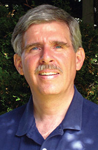
    John W. Lavrakas is president of Advanced Research Corporation, providing expertise in global positioning systems, having spent the past 34 years in GPS, working in its command and control, user operations, GPS receiver development, and satellite navigation performance analysis. He can be reached at [email protected].

  • GNSS System Mandates Would Violate International Trade Agreements

    A U.S. government representative stated at an international satnav forum that mandating use of specific GNSS services for applications such as air-traffic control, freight shipments, emergency calling, and road tolling could violate the terms of World Trade Organization (WTO) agreements that many nations, including all six GNSS providers, have signed. Regional mandates already exist for Glonass in Russia and Beidou in China, and have been suggested and extensively discussed in Europe, as a way of stimulating the market adoption of Galileo receiver chipsets, thus recouping some of the massive public investment in the satnav system.

    The presentation occurred during the 9th Meeting of the International Committee on Global Navigation Satellite Systems (ICG), November 10–14 in Prague, the Czech Republic.

    Jason Kim, a senior policy analyst at the U.S. Department of Commerce, stated that the United States and EU already enjoy a productive dialogue on GNSS trade issues under the 2004 U.S.-EU Agreement on GPS-Galileo Cooperation. In that agreement, both parties agreed to consult before establishing GNSS standards, certification requirements, regulations, mandates; affirmed their non-discriminatory approach with respect to GNSS trade; and established a working group to consider non-discrimination and other trade related issues. Finally, the United States and the European Union recognized and reiterated in 2004 their commitments to WTO rules including those governing technical barriers to trade (TBT), specifically, that there would be no goods discrimination based on non-tariff measures such as regulations, standards, testing, or certification.


    Kim made the remarks in the course of his presentation titled “GNSS Market Access.” He told GPS World that his presentation was directed less at the European Union, which has been conscientious of its WTO commitments, and more towards the rest of the ICG members, including non-provider nations that may be asked by GNSS providers to mandate specific systems..

    “To promote adoption of their systems,” Kim stated, “GNSS providers are considering/implementing equipage mandates for various applications: aviation, motor-carrier and HAZMAT vehicle tracking, car accident reporting (eCall/ERA-GLONASS), and emergency phone calls (E112).

    “The United States recommends technology-neutral, performance-based standards,” Kim continued, giving as example the U.S. E911 rules that specify a required positioning accuracy and then allow wireless carriers to choose the best technical solutions according to their lights.

    The U.S. government presentation at ICG revealed particular concern that regulations under consideration could adversely affect the sales of U.S. GPS-enabled hardware in many industry sectors. All members of the WTO, to include the six GNSS providers on the ICG, are bound to a range of trade agreements designed to promote open market access, all cited in the Prague ICG presentation: the General Agreement on Tariffs and Trade (GATT), the Agreement on Technical Barriers to Trade (TBT), and the General Agreement on Trade in Services (GATS). The United States, Europe, Japan, and 12 others are also parties to the WTO Agreement on Government Procurement (GPA).

    European Commission officials have publicly and recently stated that they are considering how to stimulate Galileo use, in particular through regulatory measures requiring that navigation equipment be installed on aircraft, automobiles, and other platforms.

    “Requiring specific systems arbitrarily prevents or penalizes imports of goods having perfectly functional GNSS capability,” said Kim. “WTO members must comply with TBT obligations in setting technical regulations.”

    He concluded his presentation by requesting that the ICG Providers’ Forum add GNSS market access to its future agenda for discussion, and consider developing a new principle on market access for future adoption.

    The ICG, an organization established in 2005 under the umbrella of the United Nations to discuss GNSS to benefit people around the world, “promotes voluntary cooperation on matters of mutual interest related to civil satellite-based positioning, navigation, timing, and value-added services. The ICG contributes to the sustainable development of the world. Among the core missions of the ICG are to encourage coordination among providers of global navigation satellite systems (GNSS), regional systems, and augmentations in order to ensure greater compatibility, interoperability, and transparency, and to promote the introduction and utilization of these services and their future enhancements, including in developing countries, through assistance, if necessary, with the integration into their infrastructures. The ICG also serves to assist GNSS users with their development plans and applications, by encouraging coordination and serving as a focal point for information exchange.”

  • Out in Front: My Heart in My Sleeve

    The next time I see Paris, I will be swinging down the boulevard in a brand new set of threads. An elegant, location-enabled set of threads that will take me by the sleeve and lead me through the City of Light.

    This wearable experiment goes by the name — of course it does — Navigate, a new line of city-specific, location-enhanced apparel. Either plug or Bluetooth the jacket (the press materials are not clear on this point) into your smartphone, download the appropriate city guide with walking tour, and start your adventure. Stash the phone in the pocket of the houndstooth jacket with red felt collar flips, no further need to look at it. Vibrations along left or right arm tell you when to turn; their frequency, intensity, and placement vary to indicate soft turn, merge, or hard turn.

    Oh, I love the colorful clothes she wears, and the way the sunlight plays upon her hair . . . I’m pickin’ up good vibrations, oom bop bop, she’s giving me excitations, oom bop bop. 

    Good, good, good, good vibrations. 

    “How we can ease the stress of navigating an unfamiliar path without interfering with the experience of discovering a new place?” asks Billie Whitehouse, design director of Wearable Experiments. “No longer do you need to hunch over a map or smartphone. Now you can experience fill-the-blank-here as a traveler rather than a tourist.” 

    Not interfering with the experience of discovering a new place: that caught my attention. In my misspent youth, I traversed the upper Amazon, the Andean highlands, and the Galapagos Islands unencumbered by a camera. To my lasting regret. I thought the device lifted to my eyes would interfere with my discovery and experience. Now I see my error. Instead of subtracting a layer of technology from my travel trunk, I should have added one. That GPS did not exist at that time, except as a gleam in young Col. Parkinson’s eye, perhaps absolves the fault in this case.

    “The skin is a vastly underutilized form of communication,” says Wear:Ex technical director Ben Moir. “Haptic vibrations are built into a full physical language, allowing the technology to communicate critical information. Technology doesn’t need to be invasive or obtrusive. It should be designed with the human at the center.”

    From signals in space to the surface of my skin. It doesn’t get much more human-centric than that. 

    Je me baladais sur l’avenue,

    Le coeur ouvert à l’inconnu.


    Also read GPS World’s December cover story on GNSS chip architecture for wearables, “The Fashion Demands of Always-On.”


  • Handheld CEO Predicts Mobile Computing Trends for 2015

    Handheld CEO Predicts Mobile Computing Trends for 2015

    Jerker Hellström, founder and CEO of Handheld Group.
    Jerker Hellström, founder and CEO of Handheld Group.

    Jerker Hellström, founder and CEO of Handheld Group, has identified three key trends in mobile computing in 2015. Handheld is a maker of rugged computers for professionals.

    His predictions:

    1.    Larger displays even for rugged mobile computers. 

    “Rugged laptops, tablets, PDAs and smartphones continue to be the fastest growing market mobile computer segment, and just like the screen size of smartphones for the mass market has increased, so will the displays of rugged computers. Screen size is the “$64,000 question” in the rugged computer segment — it is a  major consideration for all users, but it is also linked to the application and how data and information are presented, both in terms of how it is captured and how it is communicated to the end user. I foresee a stronger demand for maximum screen real-estate in the smallest, lightest possible form factor. (One real-life example would be the recently launched Nautiz X8 by Handheld with a huge 4.7-inch display for an IP67-rated rugged device).”

    2.    Higher IP ratings. 

    “Mobile computers across all market segments are increasingly being manufactured, and marketed, as more durable, more rugged and with higher IP ratings (ingress protection against water and dust). This a function of computers, tablets and smartphones being with us all the time, everywhere. The consumers demand durable devices that can be knocked around a bit! But it has also become a marketing gimmick. Some devices are now advertized as having the previously unattainable IP68 rating. But do the customers actually understand it? It actually means nothing unless the manufacturer informs us of the submerged time and depth. I expect a continued upwards ‘IP rating creep’ but also an invigorating discussion about the definition and value of IP ratings and the tests carried out on mobile computers.”

    3.    Increasing interest for Android. 

    “Microsoft Windows Mobile or Windows Embedded has for a long time been the operative system of choice for rugged mobile devices, albeit with increasingly stronger competition from Android. 2015 will be the year when he industry truly embraces Android. The rapid growing of Android consumer phones has standardized the Android user behavior and generated a spillover effect to the industrial sector. There is an increase of industrial software being developed for Android, boosted by the first generation industrial Android devices. Also, Android can take advantage of powerful multicore CPUs in a way Windows Embedded Handheld has not been able to.

    handheld-nautiz-x8-ultra-rugged-android-W
    The Nautix X8 rugged Android handheld.

    Jerker Hellström is the founder and CEO of Handheld, a manufacturer of rugged mobile computers, PDAs and smartphones. He is a pioneer and industry veteran in the mobile rugged computer industry. In both entrepreneurial and managerial positions, he has more than 25 years of experience from developing, designing, manufacturing and marketing rugged computers globally. Jerker´s educational background is in engineering and computer science.

  • Connected Car Show: Issues Arise as Automakers Look to Autonomous Vehicles

    Hacking, Privacy, and Consumer Acceptance Top the List

    Vehicle styling, speed and looks took the back seat while capabilities driven by GPS, sensors and data were up front at this week’s Los Angeles Auto Show’s Connected Car Expo. Privacy and security, distractibility and safety, and human interfaces were all hot issues. The terms connected car and autonomous cars were being used interchangeably, as a continuum of an evolving set of capabilities. The least-asked question: If we build an autonomous vehicle, will it sell or become an expensive niche product? And how will the market respond to mechanical failures or accidents, even if the vehicles are proved to be overall safer and more reliable?

    Not Happy with Navigation. With little to individually distinguish car models, auto makers are looking to infotainment to uniquely brand their vehicles. Yet drivers identify navigation and multimedia among the “lower quality” features of their vehicles. While consumers report that the quality of almost all other features of their vehicles are improving, they indicate that the quality of their navigation and multimedia are declining. “The problem is overly complex systems,” reports Renne Stephens of J.D. Power. “Usability is now considered by consumers as a factor of quality.”

    Car makers are under enormous pressure to add functionality demanded by consumers, and make the whole experience simpler. Many of the features embraced by automakers have not attracted the interest of drivers. Stephens reports that valued features include surround view camera with rear vision, wireless charging station, near field communication and smartphone field integration. What they don’t value are eye tracking, tactile touch screens, hand gesture control and laser headlights.

    Hacking. Discussions on security were enlivened with the inclusion of hacker Chris Valasek. You may remember that last year Valasek and his partner, Charlie Miller, hacked into the steering and brakes of a Prius and Ford Escape, solely by attaching a laptop to the vehicles. Members of an Israeli intelligence unit reported that they had remotely hacked into a vehicle wirelessly via an aftermarket insurance dongle (in this case, Zubie) that was plugged into the vehicle’s OBDII port. Dongles might make people safer drivers, but could they lead to an unwanted adventure?

    Valasek and Miller created a list of the most hackable vehicles with the Jeep Cherokee, Cadillac Escalade and Toyota Prius as the most vulnerable. The Dodge Viper, Audi A8 and Honda Accord top the most secure list. Malicious attacks could range from enabling a microphone to eavesdrop to the catastrophic, such as controlling steering or brakes.

    Valasek assured conference goers that hacking vehicles isn’t easy. No matter how many layers of protection are created, no vehicle that communicates with the outside world will be hack-proof. Last month, automakers announced that they are forming a consortium that will be dedicated to deterring “black hat hackers” and will create a venue for the auto industry to share information about hacking attempts.


    Dreams and Nightmares. The best-case scenario for the automotive OEMs is a connected vehicle industry in which they control the ecosystem and derive high revenues, as well as driverless cars starting to become common around 2024. In reality, the OEMS may encounter lagging consumer acceptance, perhaps shattered by catastrophic accidents, reliability issues or privacy troubles. Regulation might cause insurmountable constraints. The driverless car could become a niche product and a costly failure.

    In another possible scenario, the connected autonomous vehicle becomes a success, but the tech and digital companies win the market with parallels similar to how the PCs took the industry from IBM. The OEMs become a pipeline with little value and the tech companies take home the bacon. If the market fails, the VCs will stop investing and some of these tech companies may fold. The Tesla offers an example of how this scenario might unfold.

    Privacy. Automakers are making a commitment to privacy in the vehicle far beyond that made by companies like Apple or Google, which are vying for a piece of connected vehicles. Nineteen automakers just signed a set of principles delivered to the Federal Trade Commission. “Google may want to become an automaker, but we don’t want to become Google,” said Mitch Bainwol of the Alliance of Automobile Manufacturers. The OEMs provide assurance that they will not share information from vehicles that is streamed back to automakers or that is downloaded from the vehicle’s computers. They pledge information won’t be handed over to authorities without a court order, sold to insurance or other companies or used to bombard them with ads for Starbucks, gas stations or other businesses they drive past, without their permission.

    “You just don’t want your car spying on you,” said Marc Rotenberg of the Electronic Privacy Information Center. “That’s the practical consequence of a lot of the new technologies that are being built into cars.” The automakers signing on to the principles are: Aston Martin, BMW, Chrysler, Ferrari, Ford, General Motors, Honda, Hyundai, Kia, Maserati, Mazda, Mercedes-Benz, Mitsubishi, Nissan, Porsche, Subaru, Toyota, Volkswagen and Volvo.

    Uptake. About half of us like to drive and the other half just want to get there, reports futurist Peter Schwartz. Younger populations are increasingly in the transport camp, as illustrated by the popularity of Uber, Lyft and Zip Cars. How to win the whole market is to “automate the boring parts of driving,” says Håkan Samuelsson of Volvo.”

    J.D. Powers reports that consumers perceive the autonomous vehicle as a driver completely detached from the driving experience. This isn’t too close to the reality that is within reach; the driver will need to be engaged and ready to assume control when called upon. But the dream of catching a few winks on the way to work is a good one. Will this vision be led by Detroit or Silicon Valley? We should find out soon.

  • Autonomous Vehicles Are Coming…But When?

    IAV_OMD_3760 Photo: Denso
    IAV Automotive Engineering test vehicle. Photo: Denso

    The autonomous, or driverless, vehicle market seems to be a big side topic at connected car conferences. Location technology will continue to play a role in the development of autonomous vehicle markets. However, many view a fully autonomous vehicle to be more than 10 years away — these are usually folks from the auto industry or academia. Others, those who lurk around Silicon Valley, believe that driverless cars will be on the road in half that time…and once again, if Detroit doesn’t move on it, they will.


    Just as GPS was once thought of as science fiction — something that naysayers said would not be fully operational for decades — autonomous vehicles are now thought of as an extension of the connected vehicle market. However, technology and legal issues will make the implementation of an autonomous, or driverless car, a tenuous road in the next few years.

    One executive from Verizon Telematics, which is a major player in connected car technology, said it is going to take time, perhaps between the years 2025-2030, to grow the autonomous vehicle market.

    “You just can’t flip a switch and have autonomous vehicles [on the road]. You have to take baby steps to develop a network, build an infrastructure and condition the marketplace,” said Kevin Link, Verizon Telematics senior vice president. “The collaboration is going to have to be more than one player, including the government. It was a while before desktop computers evolved into laptops.”

    While the technology hurdles will be significant for autonomous vehicles, there are features today that will help shape the market, Link said. “Mercedes cars remind people to steer and turn around corners, when to stop at a safe distance and to change lanes,” he said. “These are not taking you from point A to point B autonomously, but real-time connected car features will feed into the autonomous car.”

    The evolution of autonomous vehicles will not be derailed at this point, given the intensive research and investment focus from both the private and public sector, said Tim Johnson, NextEnergy director of transportation initiatives. “However, cars that ‘drive themselves’ will not be in mass production in the next five years. Ten years, maybe. Five, no,” he said. “This is not a technology-limited premise. The technologies are rapidly approaching realistic use in limited applications, but the regulatory, liability and infrastructure aspects are far from being fully implemented in the next five years.”

    Technology Hurdles Await Early Autonomous Vehicles — More Regulation than Technology?

    Some of the technology hurdles center around the speed, capacity and logic of the vehicle and infrastructure systems to manage the significant amount of information required for self-driving vehicles, Johnson said. “If it was possible to wave a magic wand and have all vehicles made simultaneously capable of these communications and logic decisions, it would be much more viable to create a mass, public environment for self-driving cars,” he said. “In reality, there will be an extensive transition period, possibly 15 to 20 years, where capable vehicles will need to deal with incapable vehicles. Once again, this is not so much a technology issue as it is policy, regulation and liability.”

    Autonomous Products Already Out There…

    Autonomous vehicles will only continue their current momentum as the technology for assisted driving is already well underway with features like self-parking, lane departure warning, predictive collision warning, back-up collision intervention and blind spot prevention, said Scott Frank, Airbiquity vice president of marketing.

    An example is the Infiniti Q50, which uses Airbiquity technology for Infiniti InTouch Apps. “What we’re going to see from here is a shift from driver assistance to zero driver involvement — the ultimate expression of autonomous vehicle — where the car does all the driving and there isn’t even a steering wheel or brake pedal,” Frank said. “We won’t see fully autonomous vehicles becoming commonplace in five years’ time due to the massive amount of technology, infrastructure development and integration that needs to happen to ensure the requisite amount of safety.”

    NextEnergy’s Johnson said that cars that drive themselves are already in use in restricted access sites, such as military bases, restricted commercial and university locations, national lab campuses and more. “These are the first real-world applications of both the vehicle and infrastructure technologies to test the practical limits of semi-autonomous driver-still-behind-the-wheel cars,” he said. “Much like the FAA use of limited test sites for the development of regulatory aspects of drone flight, these sites are providing the information and insight to move the potential of cars that drive themselves closer to everyday use.”

    Denso-W Photo: Denso
    A Denso autonomous test vehicle drives the track while a plastic friend looks on. Photo: Denso

    Will Public Transit Be the First Proving Ground?

    Most companies have different opinions when asked whether the public transit area will be the first major market, and serve as the catalyst, for autonomous vehicle growth. “Although we don’t know for sure, it could be that automated public transit programs, will operate in controlled environments with known routes [meaning low speed operation with pedestrians/bicycles operating on the same thoroughfare, but the automated transit system does not have rails or guide ways — the route planning is easily changeable with no impact to the transportation infrastructure],” said Roger Berg, Denso North American Research and Development office vice president.

    Denso believes the autonomous vehicle market will encourage additional functionality within the premium car model lines, but gradually these advanced driver assist systems will become more and more common and eventually spread through even the economy car segment, Berg said. “First systems deploy warnings or simple lateral and longitudinal vehicle control. But then functionality for what most people refer to as ‘driverless cars’ or ‘automated driving’ would only be usable under fairly benign driving and traffic conditions, such as some level of automated highway driving,” he said.

    Public transit as an “early adopter” business model is viewed to be less probable in the near term as many of the technical challenges facing autonomous operation require significant research and development and capital investment, said Chris Hennessy, IAV Automotive vice president, engineering. “Most of this capital is centered on markets where the return on the investment can be substantial. At the moment, the most likely scenario for a reasonable ROI is in the premium-brand automotive market, where consumers are willing to pay a premium for new technology,” he said. “This market and the technology growth that will occur from this early-adopter market will provide a foundation for cost-effective proliferation of this technology to other markets, where either the operational boundary conditions are narrower or the available capital is lower, which is typically where public transit would fall. Exceptions to this condition could be analogous to the light-rail market, where the interaction to the general public can be controlled and managed with isolated tracks or lanes of travel, but this would require significant planning and capital investment in infrastructure.”

    Airbiquity believes that public transit will not be a first adopter. “No, the first adopters will be private parties in urban areas providing a value proposition to people struggling with congested cities, long commutes, and high parking costs. You’re going to see small and innovative companies offering car services with autonomous vehicles operating on city grids at lower speeds,” Frank said. “They will source the autonomous vehicles from non-traditional automotive makers that move faster than traditional automotive makers. Local government will also be involved, since they own the majority of the infrastructure and need to ensure safety standards are established and met.”

    In other location news:

    • Kore Telematics, fueled by a large investment in it by ABRY Partners, bought RacoWireless in an all-cash deal, according to published reports. The transaction will give the companies a combined 3 million M2M subscribers.
  • Whatever Happened to SketchUp? — Trimble Dimensions

    Earlier this month, I attended the Trimble Dimensions conference in Las Vegas. More than 4,000 attendees made it the largest Dimensions conference to date. Since Trimble has been on a corporate acquisition binge for the last 10+ years, one has to pick an area of interest to focus on; otherwise, it’s easy to be overwhelmed with their wide offering of geospatial technology. In my Survey Scene newsletter earlier this month, I focused on Trimble’s satellite-based GNSS augmentation services. In this month’s GSS Monthly newsletter, I’d like to touch on Trimble’s activities in the geospatial software arena.

    If you recall, Trimble bought SketchUp from Google a couple of years ago. SketchUp is software for 3D modeling used for a wide range of apps from interior/exterior architectural design to video game design. It’s not hard to understand why Google would want to sell SketchUp. Google products like Google Earth and Gmail are everyday consumer-friendly products that have mass appeal to a huge audience. SketchUp is a product that takes a higher level of geospatial user knowledge and time investment to use. It seems to be a perfect fit for a geospatial-oriented company like Trimble.

    I used to be involved in a lot of 3D modeling projects in the landscape architecture area. I know how labor-intensive it is to generate high-quality 3D models and 3D video fly-throughs. I also understand the value that 3D models offer in bringing a proposed design to life. For example, look at the following photo taken of an unimproved site:

    SH12_BeforeSH12_BeforeSH12_Before_Small-SketchUp-W

    To visualize the golf course architect’s design, following is a 3D model of a proposed golf hole overlaid on an image of the unimproved land:


    SH12_Small-SketchUp-W

    Imagine how much more effective it is to show a client this sort of visualization, rather than trying to explain this using a 2D set of architectural or engineering plans.

    This is the kind of visualization that SketchUp is designed to address, but more structure (building) oriented. The impact on the the client is the same, bringing 3D and color to design ideas. In fact, SketchUp goes further than just helping designers visualize their ideas for their clients. In some cases, it can produce a list of materials to construct the building. At a short briefing I received at Dimensions, Trimble said that the following structure was designed, and a list of building materials was generated, using SketchUp.


    SketchUp_Dome-W

    OK, it’s not a high-rise building and SketchUp can handle more complex designs than this, but this illustrates where the technology is headed and that the fundamental workflow exists. Also, it shows that this type of technology is becoming available to a wider audience. I recall that 10 years ago, we needed a lot of computing horsepower, sophisticated software (such as 3D Studio Max), very specialized technicians, and a lot of time to generate 3D visualizations. SketchUp brings this capability to a wider audience.

    For geospatial professionals, there’s obviously a lot of applications for SketchUp. A simple, yet powerful task is bringing Google Map imagery and topography data into SketchUp to give your buildings context. Following is a five-minute video describing how to import a Google Map into SketchUp:

    To learn more about SketchUp (free and Pro versions), a number of YouTube videos are available, as well as videos of SketchUp’s annual conference called SketchUp 3D Basecamp.

    Seven Best New Features of SketchUp 2014 (five-minute video):

    Lastly, following is a collection of YouTube videos from SketchUp 3DBasecamp 2014 (60 minutes) for you to peruse if you’re interested:


    Unmanned Aerial Systems (UAS)

    Of course, UAS are still all the rage. While Trimble showed off its UAS product lineup (a la its 2012 acquisition of GateWing), last month in Reno, Nevada, there was a conference entitled UAS Mapping 2014 that was focused on UAS for mapping. More than 500 geospatial professionals attended to view the UAS technology demonstrations. We’ll have a report on this conference in next month’s GSS Monthly newsletter. UAS technology is still in the early stages of development (and, of course, still not legal to use commercially in the U.S., according to the Federal Aviation Administration) so a lot is happening.

    There’s certainly a push toward using low-end UAS for GIS mapping. The UAVs themselves are becoming so inexpensive that the image-processing software ends up costing more than the UAV. For example, one image-processing company I hear about quite a bit is Pix4D. The company recently announced its Pix4Dmapping app that will turn a $900 DJI Phantom 2 Vision UAV into a 2D mapping and 3D modeling system. If you’re interested in the capabilities of this low-cost UAV mapping system, take a peek at the following 60-minute webinar from Pix4D.

    Thanks, and see you next month.

    Follow me on Twitter at https://twitter.com/GPSGIS_Eric

  • Professors That Make a Difference

     Being First

    Despite being an avowed Anglophile since my first visit to the United Kingdom, somewhere around 50+ years ago, I just could not help myself. Professor David Last, Professor Emeritus at the University of Wales (Bangor) and former president of the Royal Institute of Navigation (RIN) was holding forth, with that wonderful, attention-arresting public school accent, on weighty PNT (position, navigation and timing) matters before an awestruck audience.

    Professor Emeritus David Last.
    Professor Emeritus David Last.

    And what did I do? I just could not stop myself reminding him and everyone within earshot that the American Institute of Navigation (ION) predated the British Royal Institute of Navigation by more than two years. The point being, of course, that while two years actually makes little difference in the scheme of things, actuarially speaking we yanks rarely have the opportunity to make such a claim where our stiff upper-lipped Red Coat cousins are concerned. So, when the opportunity presents itself, as it typically does at ION GNSS+, then in my opinion, we former colonists just have to jump in with both feet — or one if by land and two if by sea, and all that.

    An even more compelling argument for being first revolves around GPS versus Galileo operational satellites. The first GPS operational launch occurred in 1978, while Galileo has yet to launch a non-R&D operational PNT satellite, into a useable orbit that is. Now, before you accuse me of being smug, I am actually making a case for increased cooperation between the United States Air Force (USAF) and our European counterparts (ESA) where precision positioning, navigation and timing (PNT) schemes are concerned. For when it comes to satellite navigation and PNT, we yanks can definitely declare “been there, done that” mistakes and successes. What better place to “crow,” or rather, impart our considerable knowledge and network with fellow PNT aficionados, than at ION GNSS+.

    ION GNSS+

    All vocal eloquence jealousies and juvenile kidding aside, in many respects the ION GNSS+ event is actually the epitome of international cooperation in the PNT and GNSS (Global Navigation Satellite System) arena. This annual premiere event is described as “the world’s largest technical meeting and showcase of GNSS technology, products and services,” and I wholeheartedly agree. Indeed, the 2014 event, which took place from September 8-12 at the Tampa Convention Center in Tampa, Florida, had the stated goal of bringing together international leaders in GNSS and related positioning, navigation and timing fields to present new research, introduce new technologies, discuss current policy, demonstrate products and exchange ideas. It was a networking paradise in a wonderful, albeit somewhat steamy, venue, which you can review in two excellent videos concerning the event at the ION website.

    This ION conference improves every year in content and attendance, and this year was no exception. Congratulations to Lisa Beaty and her whole team for a great conference, year after year. My favorite events are the annual GPS World Leadership Dinner and the prestigious annual ION Kepler award luncheon. Notice a trend?

    GPS World Leadership Dinner

    This much ballyhooed event becomes more and more of a draw each year. Tickets are coveted (as scare as hen’s teeth as Granny used to say) and competition is fierce. Every year we have about twice as many people wanting to attend as we have room to accommodate them. So the competition is never boring. This year was special in that one of our own GPS editors was nominated for an award and was overwhelmingly elected to receive it.

    The Leadership Award winners this year were Javier Benedicto Ruiz, the Galileo Project Manager from the European Space Agency (ESA), who won in the Satellites category, while an old friend Sherman Lo, who is a senior research engineer and associate investigator (APNT) at Stanford University, won in the Signals category. Our own Eric Gakstatter, contributing editor for Survey and GIS from GPS World, won in the Services category; and finally Oliver Montenbruck, who is head of the GNSS Technology and Navigation Group, from DLR, the German Space Operations Center, won in the Products category.

    The 2014 leadership awards, determined by a poll of 40 industry professionals, await the start of the ceremony.
    GPS World 2014 Leadership Trophies.

    The invited guests, and there was not an empty seat in the house, heard various perspectives from sponsors Lockheed Martin, Exelis, Raytheon, and Braxton Technologies, as well as visions of GNSS progress from our four award winners.

    This event will be covered in much more depth in our December issue, but suffice it to say it was as usual a great event. I wonder from year to year how we will ever top the previous year’s entertainment, which always involves audience participation, but Alan Cameron just keeps coming up with outrageous ideas that seem to always pan out. Hope to see you there in Tampa next year.

    The Kepler Award

    This year, the highly prestigious ION Kepler Award was won by Dr. Pratap Misra. Even though I am happy to say that through the years many of my friends and colleagues have won this coveted award, I can honestly say, in my opinion, there has never been a more deserving award winner than Professor Pratap Misra.


    [Correction: The newsletter summary of this article misspells Pratap Misra’s name. We apologize for the error.—Editors]


    Pratap Misra, 2014 Kepler Award recipient.
    Pratap Misra, 2014 Kepler Award recipient.

    I have had the good fortune to know Professor Misra for many years, and frankly erroneously assumed, along with many others, that since he is so obviously deserving he had previously won the Kepler Award.

    The Kepler Award is presented annually by ION in recognition of an individual’s unparalleled, sustained and significant contributions to the development of satellite navigation. It is the highest honor bestowed by ION’s Satellite Division. Professor Pratap from Tufts University meets and exceeds all of these qualifiers and more. He is simply self-effacing and polite as he quietly goes about being the best in all he endeavors.

    Throughout the years, I have found Pratap to be extremely dedicated to his work, and more recently to his students. These are key attributes. Academically, I can honestly say that the authoritative tome Global Positioning System: Signals, Measurements and Performance that he coauthored with, another friend and colleague, Professor Per Enge of Stanford University, is among the most dog-eared in my PNT library. This widely praised volume is often described as a “comprehensive introduction to GPS: the system, signals, receivers, measurements, and algorithms for estimation of position, velocity, and time.” And while it was originally intended as a textbook for senior or graduate-level engineering courses, it also serves remarkably well as a self-study guide for practicing engineers and as a reference tool for writers and researchers. I consider it to be one of the three PNT bibles that are a must-have in every PNT subject-matter expert’s (SME) library. (The other two are  Global Positioning System: Theory and Applications, Volumes 1 and 2, by Bradford W. Parkinson and James J. Spilker, and Understanding GPS: Principles and Applications, Second Edition, by Elliott Kaplan and Christopher Hegarty.)

    Revised Second Edition by Pratap Misra and Per Enge.
    Revised Second Edition by Pratap Misra and Per Enge.

    In recent years, Pratap Misra has been honored as both an ION and IEEE Fellow and has served as a past chairman of the ION Satellite Division. He has held numerous volunteer positions within ION, but most recently he has focused on something near and dear to his heart, the support of student programs. This is where Professor Pratap Misra is without peer. Frankly it is obvious that his students adore him, and it is due in no small part to his single-minded dedication to and concern for them.

    Every time we meet, the majority of his words and thoughts concerns his students. Their welfare is always uppermost in his priority list. Inevitably, while we are attempting to conduct a quiet and private conversation or interview, we are constantly being interrupted by well-meaning students, past and present, who just want to thank Pratap for his help and support. I could fill up several pages with the technical accomplishments of Professor Pratap Misra, but none of those accomplishments, recognitions or awards mean as much to him as the love, support and success of his students. It is so obvious to anyone who pays attention that he wholeheartedly thinks of his students as and treats them just like family.

    I am sure, or at least hope, we all have past professors or teachers in our lives that we remember fondly, and then there are the few or perhaps only the one that changed the course of our lives for the better. Professor Pratap Misra is one of those rare latter individuals, so deserving of the appellation — a professor that made a difference in the lives of his students. I am so proud that he deservedly won the Kepler Award and am deeply honored that I can call him my friend.

    GPS-IRT Update

    The Global Positioning System Independent Review Team (GPS-IRT) is now officially part of the Independent Strategic Assessment Group (ISAG) under the auspices of the Institute for Defense Analyses (IDA). For 19+ years, the GPS-IRT was a separate team within IDA that researched GPS matters with the “goal of insuring both the military and civilian communities would benefit from new GPS/PNT capabilities and services.”

    As a result of this organizational change, Air Force Space Command (AFSPC) chose to formally recognize the GPS-IRT’s 19+ years of effort in support of GPS modernization.

    Last Thursday, General John Hyten (USAF), the commander of Air Force Space Command, presented a commemorative plaque to Mr. Kirk Lewis, the executive director at IDA, for both the GPS-IRT and the ISAG. The plaque will be displayed with the GPS satellite on permanent display at AFSPC headquarters, in the James V. Hartinger building on Peterson Air Force Base, Colorado. The plaque contains the names of the four prestigious chairmen who led the GPS-IRT over the last 19 years, as well as the names of the members of the IRT over that same time period. Sadly, two of the chairmen and five of the members are no longer with us, but we can only hope they are looking down upon us fondly and giving us guidance of a different sort.

    Until next time, happy navigating, and remember: GPS is brought to you courtesy of the United States Air Force.

  • Trimble Dimensions Provides Focus on Range of Satellite-Based Correction Services

    The 2014 Trimble Dimensions User Conference is being held in Las Vegas this week. Photo: Trimble
    The 2014 Trimble Dimensions User Conference is being held in Las Vegas this week. Photo: Trimble

    With more than 4,000 attendees, this year’s Trimble Dimensions User Conference was the largest ever and, I must say, a well-organized event chock full of technical content — enough to squelch the most intense geospatial hunger pangs you might have.

    One could write a book on all the technology and market segments that Trimble is pursuing and offering solutions for. In addition to a wide range of GNSS, geospatial, construction, control, and data management systems previously offered, Trimble boasted a USB stick full of press releases with new product and service announced at Dimensions. So, the challenge is deciding what to write about without writing a little bit about everything.

    After my first day at Dimensions, it became clear to me what I needed to do. Among the many product and service announcements was a new GNSS correction service named Viewpoint RTX. While I’ve tried to stay up to speed on Trimble’s various GNSS real-time correction services, this one was the straw that broke the camel’s back for me. I decided I needed to get a solid grip on the range of real-time GNSS correction services that Trimble offers because the picture was getting fuzzier, at least to me, with each new real-time correction service introduced. It used to be pretty simple to decipher; not so much any longer. So I had a conversation with Patty Boothe, general manager of Positioning Services at Trimble. Patty, a 15-year Trimble veteran, was appointed GM of the newly formed group three years ago. Here’s the low-down on the services.

    Remember, Trimble acquired the land portion of OmniSTAR’s business a few years ago. For years, OmniSTAR has been one of the two dominant commercial satellite-based, real-time GNSS correction services (the other being John Deere’s Starfire service, as well as new entrant Terrastar). The OmniSTAR acquisition was Trimble’s entry into the satellite-based, real-time GNSS correction services business. Since then, Trimble has introduced the RTX (not to be confused with RTK) range of GNSS correction services. You might say that OmniSTAR and RTX are competitive services within Trimble. They are, to a certain extent, and I’ll attempt to clarify that below.

    Following is a list of Trimble’s real-time GNSS correction services, starting with the OmniSTAR services:

    OmniSTAR VBS: Satellite-based, real-time submeter service. The VBS service has been made obsolete largely by free public satellite-based augmentation systems (SBAS) such as WAAS/EGNOS/MSAS/GAGAN/SDCM. It is still used in geographic regions where free public SBAS don’t exist, primarily South America, Central and Southern Africa, and Australia. GPS-only service. Requires single-frequency receiver (L1).

    OmniSTAR XP: Satellite-based, real-time 15-cm service based on Jet Propulsion Lab (JPL) technology and delivered to users on the ground via OmniSTAR’s geosynchronous satellite network. GPS-only service. Requires dual frequency (L1 and L2).

    OmniSTAR HP: Satellite-based, real-time 10-cm service based on OmniSTAR’s reference station network and delivered to users on the ground via OmniSTAR’s geosynchronous satellite network. GPS-only service. Requires dual frequency (L1 and L2).

    OmniSTAR G2: Satellite-based, real-time 10-cm service based on Jet Propulsion Lab (JPL) technology and delivered to users on the ground via OmniSTAR’s geosynchronous satellite network. GPS+GLONASS service. Requires dual frequency, dual constellation (L1 and L2).

    To use OmniSTAR services, one must have an OmniSTAR-enabled GNSS receiver. There are a several receiver manufacturers that support OmniSTAR GNSS correction services, such as NovAtel and Hemisphere GNSS, in addition to Trimble.

    After, or at nearly the same time, Trimble acquired OmniSTAR, the company launched its RTX GNSS correction service. RTX’s infrastructure consists of ~110 GNSS reference stations around the world working to create high-precision corrections on a near global scale. The first significant differentiator is that Trimble RTX services are only offered on Trimble GNSS receivers, so you’ve got to be “all in” with Trimble to utilize RTX.

    Viewpoint RTX: Internet-based (notice I didn’t write satellite-based), real-time submeter service. This is a new service introduced this week at Dimensions for the new Leap GNSS receiver and the Geo7 GNSS handheld. GPS+GLONASS service. Requires single-frequency receiver (L1).

    Rangepoint RTX: Satellite-based, real-time 50-cm service. GPS+GLONASS service. Requires dual-frequency receiver (L1 and L2).

    Centerpoint RTX: Satellite-based, real-time 4-cm service. GPS+GLONASS service. Requires dual-frequency receiver (L1 and L2).

    The above are the three RTX services. There are some options for the above, but let’s talk about satellite-based GNSS correction services for a minute.

    The advantage of satellite correction services is that, because GNSS corrections are delivered via satellite, your receiver doesn’t need to be connected to the Internet or have any other sort of terrestrial radio communications to receive data from the GNSS reference station(s). Because delivery is by satellite, you could be in the middle of a desert with no mobile phone coverage within 100 km, and you could still use OmniSTAR or RTX services. The only requirement is that your receiver needs to have direct, continuous line-of-sight to the OmniSTAR/RTX geosynchronous satellite (both services use the same geosynchronous satellites to broadcast the corrections).

    The primary disadvantage of OmniStar and RTX services is the “convergence” time required to achieve the stated accuracy service levels. With the exception of OmniSTAR VBS (sub-meter), Viewpoint RTX (sub-meter) and Rangepoint RTX (50-cm) services, the OmniSTAR and RTX centimeter and decimeter services require tens of minutes of initialization time to converge to the stated accuracy. For example, if you want to use the 4-cm Centerpoint RTX service, you may have wait up to 30 minutes for it to converge to 4-cm accuracy.

    Now, there are a couple of ways to reduce the convergence time:

    1. Start on a known point. For example, if you’re using Centerpoint RTX on a tractor for planting and you shut down for the evening, you can start it up the next morning (assuming you didn’t move the tractor), and it will converge nearly immediately.
    2. Trimble offers a fast convergence option ($) in some geographic areas where it augments RTX with local RTK reference stations. Currently, Trimble offers this service in five U.S. “corn belt” states.

    For OmniStar XP, HP and G2 services, the only way to reduce convergence time is number one above, start on a known point.

    It’s important to note that all of the centimeter and decimenter satellite-based services described above are based on real-time Precise Point Positioning (PPP) technology, which is different than RTK technology. The fundamental difference is that real-time PPP technology relies on a global, distributed network of reference stations. For example, Trimble has ~110 reference stations to cover the globe (mostly) with its RTX service. On the other hand, RTK requires a much more dense network of GNSS reference stations. For example, in Washington State there are ~100 GNSS reference stations that comprise the state-wide RTK network.

    Lastly, Trimble offers a hybird RTK/RTX service called XFill. The idea is that for RTK users who lose communications to their RTK base or RTK network can use the Centerpoint RTX as a “seamless” back-up, maintaining RTK-level accuracy (1-2cm) for the first five minutes of RTX service, and then degrading to Centerpoint RTX accuracy after 20 minutes. Trimble reports there is no convergence time when transitioning from RTK to RTX, like you would if you were starting RTX right away. Standard XFill is included with certain Trimble RTK receivers and allows up to five minutes of RTX satellite time. Last month at the INTERGEO conference, Trimble introduced Expanded XFill which is a subscription service for those users who want more than five minutes of RTX time. For those users, Patty said that users can buy blocks of RTX time starting at 10 hours.

    So, you might ask how Trimble handles the horizontal datum differences between RTK and RTX since they are likely not referenced to the same horizontal datum. For example, in the US, Trimble VRS RTK infrastructure is typically referenced to NAD83/2011 while Trimble RTX is referenced to ITRF08. There’s about 1 meter difference between the two. After finding the correct Trimble person, he said that Trimble does a 3-parameter local shift (dX, dY, dZ) on the fly when in RTK mode so that when there’s a transition from RTK to RTX, the horizontal datum difference is already resolved.

    A by-product of Trimble’s ~110 global GNSS reference station network is a real-time, world-wide  TEC (Total Electron Content) map. Since real-time PPP GNSS correction services (and public SBAS like WAAS/EGNOS/MSAS/GAGAN) rely on accurate models of the TEC in the ionosphere to account for the GNSS measurement delay, real-time TEC maps give users an indication of how the ionosphere’s TEC is behaving. This sort of map is particularly useful in attempting to predict the understand single frequency receivers using services such as public SBAS, OmniStar VBS, and Viewpoint RTX. The next time you here about an impending solar storm, take a look a the map using this link and see the TEC hotspots around the globe. Notice the more intense activity near the geomagnetic equator.

    TEC Map from Trimble's ~110 Global GNSS Receivers Photo: Trimble
    TEC map from Trimble’s ~110 global GNSS receivers. Photo: Trimble

    Shifting gears slightly, at the conference, Trimble also introduced a new mobile phone GNSS add-in product called Leap, which uses the Viewpoint RTX service.

    Trimble Leap GNSS Receiver with a Samsung Galaxy Phone. Photo: Trimble
    Trimble Leap GNSS Receiver with a Samsung Galaxy Phone. Photo: Trimble

    Thanks, and see you next month.

    Follow me on Twitter at https://twitter.com/GPSGIS_Eric

  • Out in Front: Of Rats, the Mind, World Series, and Truth

    My colleague Janice Partyka wrote a provocative blog in the Wireless/LBS Insider on discovery of the brain’s inner GPS, which won three scientists a Nobel Prize for medicine. The piece struck me so forcefully in the hippocampus, locus of my location sensibility, that I was tempted to place it here verbatim. That would not justify me, however, in drawing my pay, so I add my two cents worth. Literally. Two cents worth.

    Partyka’s theme: “How does our brain understand where our body is in space, and navigate us from home to work?” She wrote that one scientist found “a type of nerve cell in the brain’s hippocampus, our short-term memory storage bin, was always activated when a rat was at a certain place in a room. As a rat ran through a maze, a particular sequence of individual neurons fired. Other nerve cells were activated when the rat was positioned elsewhere. O’Keefe concluded that these ‘place cells’ formed a map of the room. 

    “When the rats slept, the same sequences of place cells that were fired earlier in the day fired again. Researchers think that this replay helps to transfer the rat’s memory of the maze from the hippocampus into long-term storage. Place cells also attach to memories of a particular location. When sitting at a table, a person or maybe even a rat might remember a pizza that was eaten at that spot. 

    “Many decades later, the Mosers discovered another component of the brain’s positioning system. They identified ‘grid cells,’ which are thought to act like a dead-reckoning system and generate a coordinate system to allow for precise positioning and pathfinding. The grid cells create a location to put place cells and organize position locations. Rats running around an open floor (hopefully not mine), will fire neurons that map out a grid of equilateral triangles that serve as a spatial map. Grid cells can function in complete darkness, without visual cues. Together, place and grid cells make it possible to determine position and to navigate.

    “While place and grid cells were first discovered in rats, studies using brain imaging indicate that they also occur in humans.”

    As I sit here in mid-October listening to the World Series (for some deeply buried irrationality, sleeping in the Americana of my mind, I believe that baseball is better on radio than on TV), I visualize the athletes lunging and spearing and leaping about the field of play, barely having to look because they know the cells and grids of it so well. They just react to the ball and — smack! — it arrives in the first baseman’s glove. And what of the pitcher, who knows the strike zone so totally, so certainly, so inwardly, at 60 feet’s distance from his outstretched arm, that he can navigate a small spheroid precisely, on a curved path no less, to its lower left corner?

    Technology enhances our sense of location, as we in particular know so well. But technology can be fooled, perhaps more easily than the brain. Could the brain be convinced that its body was speeding towards Libya when in reality it placidly cruised northward in mid-Adriatic? Imagine how your brain would fare against the spoofer in this issue’s cover story. 

  • Galileo: A Constellation of One?

    Matters sit not well with Galileo, the European GNSS. Only one of six currently orbiting satellites can be said to be truly and fully operational. With these troubles augmented by persistent uncertainties regarding the fitness of Soyuz rockets, despite a recent inquiry panel that identified a root cause of the August launch failure, the European Commission has nixed an upcoming December launch. The European Space Agency will have to wait until February 2015 to see if the skies clear by then for the next opportunity to place two new satellites into orbit.

    Hard-charging veteran investigative reporter Richard Langley has learned from his eastern listening post in New Brunswick that “E11 and E12 [launched three years ago] exhibit ongoing problems with the onboard clocks. E20 [launched two years ago] has experienced power-supply problems and, following a brief outage, is now broadcasting on E1 only and with a reduced power. The latest two satellites [rose August 22 of this year] are in irregular orbits and will likely not form part of the final constellation. This leaves E19 [born October 12, 2012] as the only fully operational satellite operating within specifications.

    “So, strictly speaking, only one of the currently orbiting satellites is fully operational. However, for most (E1/L1-only, single-point) users, four of the six satellites are currently quite useable. Moreover, preliminary studies suggest that, once on line, the latest two satellites will be perfectly usable, despite the irregular orbits. And, as we have heard, there will be attempts to make the orbits somewhat more circular.”

    Langley cites “knowledgeable researchers” as his sources.

    The initial quartet of in-orbit validation (IOV) satellites — E11, E12, E19, and E20 — constructed by Astrium GmbH and Thales Alenia Space have experienced a range of difficulties outlined above. The decision to cancel the next scheduled launch in December of the newest duo of full operational capability (FOC) satellites, manufactured by a consortium led by OHB AG, comes on the heels of a completed inquiry that blamed a “design ambiguity” of the Soyuz rocket’s Fregat stage for the too-low orbits of Satellites 5 and 6, but left several lingering doubts about other Soyuz issues that were uncovered and must be corrected.

    The situation is complicated by further unresolved issues aboard the two FOC satellites themselves.  They each failed to deploy one of their two solar arrays on the first try. After several days of effort and re-orientation of the satellites by ground controllers, the arrays were successfully unfolded, but the cause of the initial failure remains unknown. “There is no conclusion on a root cause,” stated one official. “Was it a consequence of the bad orbit, or is there an issue with the solar array deployment mechanism? We cannot yet say for sure.”

    As for their incorrect orbit, getting them into their originally planned paths around the Earth is impossible. They simply do not have enough fuel onboard. ESA does, however, plan to raise the perigees of the satellites to get them out of the Van Allen radiation belt, which could severely damage the satellites. The agency also envisions reducing the maximum Doppler frequency shift from 9.6 kHz to at least 6.8 kHz to allow receivers to easily acquire and track the satellites but leave enough hydrazine for future station-keeping. Spokespersons hold out hope that the satellites may yet be usable somehow, someday, after some adjustment measures are taken: a rephasing, a special almanac, perhaps other adjustments.

    Overall, a disheartening picture, with some pessimists concluding that “2013 and 2014 have been lost.” The recent slip of full operational capability declaration from 2018 to 2020 may have to be revised yet again. However, lessons learned, etcetera. Galileo has had its ups and down. Advocates may draw comfort from the wisdom imparted by 19th-century German philosopher Friedrich Wilhelm Nietzsche, “Was mich nicht umbringt, macht mich stärker.” That which does not destroy me, makes me stronger.