The message to the recent European Space Solutions conference in Prague was simple enough: EGNOS is here, so let’s use it; Galileo is almost here, so let’s promote it.
Neither task is straightforward.
Take the European Geostationary Navigation Overlay Service (EGNOS), the European piece of a near-global network of terminals on geostationary satellites linked to networks of ground stations to verify GPS signal accuracy, primarily for aviation but with further applications as well. Other pieces of this global network are the Wide Area Augmentation System (WAAS) in the United States, the System for Differential Corrections and Monitoring (SDCM) in Russia, GPS-aided GEO-augmented Navigation (GAGAN) in India, and Multi-functional Satellite Augmentation System (MSAS) in Japan.
EGNOS is operational. It works. Once airports publish the required specificafions for localizer performance with vertical guidance (LPVs), aircraft with EGNOS terminals ultimately will be able to use EGNOS for flight terminations up to as low as 200 feet above the runway. Gone is the need for runway infrastructure, and welcome to the long-promised world of satellite-based augmentation systems. “It offers cheap solutions for precision approach,” said Fabio Gamba, chief executive of the European Business Aviation Association.
In the United States, where business aviation is a bigger market than in Europe, some 3,400 LPVs have been published for 1,670 airports. In Europe, the equivalent figure is 108 LPVs at 77 airports.
Why the sluggish response? Gamba cited a long list of issues, including some that appeared more political than technical. Part of the reason, some said, was that the EGNOS backers, including the company under contract to manage the system — European Satellite Services Provider (ESSP) of Toulouse, France — have not done enough to get the word out.
After all, these observers said, EGNOS suffered multiple delays, and its bigger younger brother, Galileo, has had bad press for years as its business model, ownership, regulatory backing, and schedule took turns in making eyes roll in Europe.
But that’s yesterday’s issue. Thierry Racaud, chief executive of ESSP, said EGNOS posted greater than 99 percent availability in May for its safety-of-life service, which is currently available on none of the other regional GPS augmentation systems except WAAS.
Racaud promised that the 108 LPVs signed so far would grow to 180 by the end of this year, and that 200-foot level approaches would be certified by late 2015. He said he hoped all 28 member nations of the European Union would have concluded their EGNOS regulatory approvals by 2017 or 2018.
“What we need now is more users,” Racaud said.
If EGNOS is not well known on its home turf, imagine its status in Africa, where European companies are trying to sell its adoption. Abdel Nasser Saint’Anna, director of the EGNOS-Africa Joint Program Office, said Africa should be Exhibit A for an EGNOS success pitch. Of the 2,500 runways in Africa, he said, only 177 were equipped with instrument landing systems (ILS), the system EGNOS and Galileo ultimately would like to replace.
Galileo, with Four, in Fourth
Galileo, too, appears headed for a successful adoption in many areas around the world even if, once operational, it likely will be the fourth global GNSS system in place, after GPS, Russia’s GLONASS and China’s BeiDou — not counting the large regional Indian and Japanese systems now being developed.
For those with scorecards, recall that four Galileo satellites, designed to validate the system’s performance, are in orbit. Carlos des Dorides, director of the European GNSS Agency (GSA) in Prague, said tests in May proved Galileo’s interoperability with GPS.
More importantly, des Dorides said the tests demonstrated how much better it is for consumers when their terminals access GPS and Galileo together. That should be obvious. Less obvious: Results were much better than with terminals tracking both GPS and GLONASS, he said.
The more satellites, the better? Yes, at least up to a point. Whether terminal manufacturers will see fit to incorporate all four global GNSS constellations, plus one or two of the regionals, in their hardware remains to be seen.
But the pent-up demand for Galileo does now seem better than it was as little as a year ago, despite the fact that some Asian nations attending the conference said they need Galileo to demonstrate its vitality sooner rather than later. Some officials said signal-quality issues with Beidou, and the recent GLONASS outage, will more than make up for Galileo’s delays as long as deployment progress is visible.
The fact remains that by 2020 there will be more than 100 GNSS satellites in medium-Earth orbit, in addition to the augmentation terminals on geostationary satellites.
A graphic presented by SpaceTec Partners’ Rainer Horn, whose company has been charged with preparing the Asian market for Galileo, showed just how dense the Asian skies will be with GNSS assets at the end of the decade. India, China, Japan, Taiwan, and South Korea are SpaceTec’s current Asian targets.
The message from these markets: Launch Galileo now. Drum up support. Occupy the media space.
Did the European Commission get the message? Time will tell. The next opportunity to wave the Galileo flag comes in late August, when the first two of 22 full-operational-capability satelllites will be launched from Europe’s spaceport in South America. Two more are scheduled to follow late this year.
Eight satellites in orbit by Christmas will not make an operational service, whatever the brochures say. But does that matter? Galileo now has secure funding, through 2020, for most — not all — of what it needs to launch a full constellation. Absent a new issue, by 2017 few will remember the delays.
Paul Weissenberg of the European Commission, who has seen the Galileo wars up close, reminded the European Space Solutions audience in Prague that one future Galileo customer sits outside the commission’s offices, waiting for approval to use Galileo’s PRS encrypted service. The U.S. Defense Department’s desire for Galileo does not have an expiration date. Just launch it.
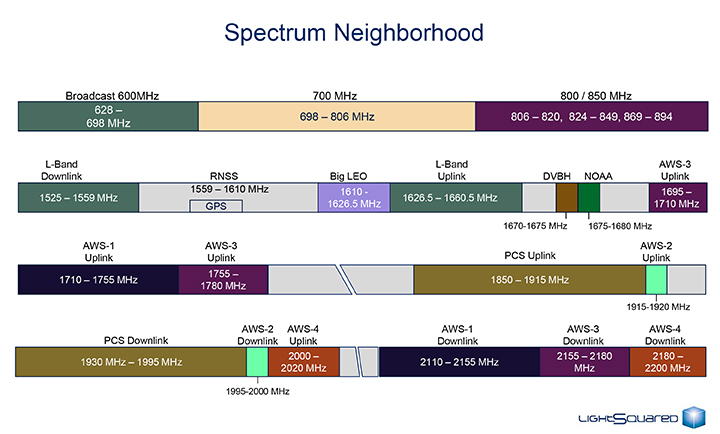
The U.S. Federal Communications Commission convened a June 20 workshop on “GPS Protection and Receiver Performance” whose bite turned out to be far less than its bark had led some in the GPS industry to fear. The hastily assembled workshop — three weeks notice was given — appeared at first notice to derive from the call for “GPS receiver performance standards” that was one of the outcomes of the LightSquared controversy of 2012. The FCC chief emphatically noted, however, before anyone else could say anything, that the meeting was “not about FCC-mandated receiver standards.” A nearly audible sigh came from the collected dignitaries.
Perhaps the slotting of “GPS Protection” into first position within the workshop’s title might have given some clue. The meeting did turn out to be a less-than-alarming gathering of stakeholders, and in fact a reiteration of the need to emphasize and safeguard critical infrastructure and public safety — two key uses of GPS.
Two weeks prior to the workshop, Brad Parkinson declared to the National Space-Based Positioning, Navigation, and Timing (PNT) Advisory Board that “A number of manufacturers are quite panicked over this because of the possibility of some superposition of, in essence, how you design a receiver for GPS. This could vastly affect the whole substance of what we are if carried to the point that someone dictates how you design a receiver. I think that’s kind of dangerous.”
But the meeting, in the end, took a positive, protective, and conciliatory tone, even as the FCC continues beating the drum for more frequencies for mobile broadband, citing the need “get more out of the radio spectrum.”
“Today is about federal and non-federal leaders coming together to discuss successful industry-driven collaborations and GPS receiver performance,” said FCC Chairman Tom Wheeler in his opening remarks. “These are not abstract issues. But let me also be specific about what today is not. It is not about FCC-mandated receiver standards. Rather it is about the best way to protect GPS operations in the context of evolving technology and adjacent spectrum activities.”
The specter of adjacent spectrum use hovered intermittently throughout the day, appearing fully in the presentation by LightSquared and one from the President’s representative. Otherwise, scant mention was made of the oft-expressed 2012 sentiment that GPS receivers needed to be modified in the way they work, to stop their alleged “peeking” into adjacent spectrum.
Peekin’? We don’t need no steenkin’ peekin’!
After further introductory remarks from the FCC’s head of Public Safety and Homeland Security Bureau, the audience heard a technology market update from the U.S. Consumer Electronics Association (CEA). The report relied almost entirely upon the European GNSS Agency’s (GSA’s) 2013 GNSS Market Report for its global statistics, while displaying some domestic charts of its own. Among the conclusions: GPS/GNSS is an enabling technology for innovation and disruption; and the consumer market, defined as road and location-based services (LBS), represents the biggest opportunity. The CEA presentation is available here.
The morning’s first panel discussion focused on the importance of GPS for critical infrastructure and public safety users, with presentations by Qualcomm, Motorola, and AT&T in addition to various government agencies. Cormac Conroy, vice president at Qualcomm, emphasized the critical role of GPS in emergency calls from mobile phones (E-911) and what he called “enhanced location services”: vehicle and pedestrian navigation, location-based alerts and reminders, and location as context in mobile apps.
Other speakers, including representatives from Ericsson, T-Mobile, Spirent, Garmin, NovAtel, and John Deere, covered GPS’s role in timing and thus controlling the nation’s power grid, the financial markets, the telecommunication network including cable TV, and the national breadbasket, precision agriculture. Paul Galyean of Deere said that “Certainty on the spectrum environment is needed. It’s difficult to design for the future without it.” And further, if GPS receivers had to filter out cellular activity, this “might impact sensitivity, involve excessive size or cost, and might cause distortion of GPS measurements.” The Deere presentation is available here.
Chris Hegarty from the MITRE Corporation gave one of the day’s most compelling arguments for not overhauling GPS receiver methodology: the extremely long lead times for commercial passenger aircraft. “Until 2022 every new Boeing and Airbus is going to fly off with $250,000 worth of navigation equipment that has three $50,000 GPS receivers and antennas and everything else, and they are going to want to use that for 20 to 25 years. So, you have a timing issue. Even if we all decided today that we wanted to do that, some communities simply aren’t going to be able to get it into place until we’re all dead.”
White House Espouses Adjacent Spectrum
Tom Power, deputy chief technology officer for telecommunications, held up the banner for “efficient use of spectrum” and pronounced the Administration opposed to “listening in.” Ironic, given its other proclivities. He advocated against some technologies exerting undue elbow room on “nearby users who want to make a change.”
Half the year is over. It’s gone. Now it’s time to figure out where the location industry is going for the remainder of the year. One analyst (actually, several) believe that the industry, fueled by indoor location and place-based advertising, is around $14 billion right now — with no place to go but up — given some bump in consumer awareness. In other news in a busy month, Google bought Skybox Imaging for $500 million in cash.
As the mid-point of 2014 arrives, with a few big location industry deals already consummated, there is a chance for industry executives to study what is going to be a strong niche market in the months ahead.
One analyst believes a big location niche is indoor analytics and proximity marketing, which is defined as nearby a store or within a business. “The latter would include ads and coupons. We’ve estimated that roughly $3.5 billion of potentially $14 billion, or so, in 2014 U.S. mobile ad revenue, will be location-based [broadly defined],” said Greg Sterling, founder of Sterling Market Research. “Of that, about $1.4 billion will be ‘geofenced’ or nearby.”
Sterling believes that the in-store component is still in an embryonic stage. “There are billions of dollars of coupons distributed every year, but most of that is still print. Some of that is in-store distribution and redemption,” he said. “A portion of that over time will migrate to mobile in or near stores.”
Sterling said there are billions of dollars available from proximity marketing, but it will take time. He cites “Mapping the Indoor Marketing Opportunity,” a report he authored for Opus Research, that says the market for indoor location and place-based marketing/advertising will surpass $10 billion by 2018. (See a preview of the report here.)
In a published report, Sterling admitted that he was nervous about the $10 billion number, but it may turn out that the figure could be conservative because of the software licensing from indoor markets.
Sterling says that while indoor positioning has been important to the older location business, it is still in its early stages. The big deal is mobile, which has brought new attention and interest to location, he said. “Indoor location will feed mobile and online marketing with data and analytics as well as targeting opportunities,” he said.
Many executives and analysts in the location industry have marginalized privacy issues; some even say it is dead with opt-in approval by consumers. However, privacy issues will continue to hamper the location industry, Sterling said.
“Privacy is far from dead. Indeed, it’s on the rise, and a major issue that everyone in the location and mobile segments needs to tackle head on,” Sterling said. “Denial, delay and obfuscation will result in regulatory intervention and/or consumer fear/rejection.”
In a blog, Sterling said that the San Francisco-based Philz Coffee chain no longer will be tracking customers after a local ABC affiliate revealed they were using Euclid retail analytics. Sterling said the ABC report acted as if it had uncovered a big government or corporate conspiracy.
Sterling will be giving the keynote address at the Place Conference in New York on July 22 at the W Hotel. Topics include proximity marketing, indoor positioning markets, privacy and other location topics.
Google Continues Location Industry Dominance with Acquisition
Google enhanced its online mapping service by acquiring Mountain View, California-based Skybox Imaging for $500 million in cash. Sources say both Google and Facebook are purchasing satellite and drone companies in an attempt to expand into other market areas.
One of the ways Google will be leveraging Skybox is in disaster relief and to improve Internet access in remote areas, something the company has been strongly pursuing.
On its website, the five-year-old Skybox said that it plans also to share in the development of the burgeoning autonomous vehicle market and continue to design its own satellites.
A Skybox satellite image of Tampa, Florida.
AT&T Expands Location Information Services
AT&T’s new Location Information Services, which includes a security function and LBS, is expanding into more than 150 countries this summer in a pilot project. The Location Information Services are enabled through an API that can notify companies when their customers, who opt-in for the service, arrive in a new country.
Some application examples, provided by AT&T, include credit card companies confirming customers have traveled to a new country as soon as a device is turned on; allowing the credit card company to either decline or approve purchases overseas; companies using the service to track the movement of equipment to prevent stolen property; and the ability for hospitality entities to offer restaurant and other suggestions to consumers based on their location.
In other LBS news:
The new Amazon Fire Phone has GPS and location functions plus a new feature, Dynamic Perspective, which can be used for such built-in apps as maps and games. The phone is available on July 25, but Amazon is taking pre-orders. In the meantime, competitor Apple has a new iOS 8 feature that allows shoppers to enter their payment details on an m-commerce site by scanning their credit card with the camera on their mobile device, according to published reports. The operating system will use sensors to provide apps with indoor positioning data.
HERE acquired the mobile predictive analytics firm, Seattle-based Medio, earlier this month. The company plans to integrate Medio’s predictive analytics, in conjunction with its map platform, to customize LBS “prediction experiences” for consumers, according to published reports. These experiences (full disclosure, I hate it when companies use the word, “experience”) may include delivering restaurant or other information at a relevant time, such as around lunch. While no financial details were released, the deal is expected to close at the end of July.
Hundreds of businesses in Brixton, near London, will be integrating Apple’s iBeacon as part of the first networks for mobile payments, according to published reports. Businesses in Brixton are switching from currency payments to mobile payments by text. Previously, iBeacons have been used for proximity offers, advertisements and product information when a user is in a retail area. The mobile payment application allows users to quickly check out, reports say.
Steven Spriggs was pulled over by a motorcycle cop for using his iPhone while driving. He immediately held it up to show the officer that he was using Apple Maps, and not talking or texting. More about Mr. Spriggs later. With approval of the pending transportation bill in Congress, smartphone maps and navigation will be regulated. The National Highway Traffic Safety Administration (NHTSA) would receive the power to regulate apps like Google Maps or Apple Maps. NHTSA’s job would be to review navigation apps and order changes to decrease driver distractibility.
Guess who is in favor of this new regulation for smartphone apps? Automakers. Embedded navigation systems, those found in the dashboard of vehicles, are already regulated by NHTSA. Smartphone navigation apps are a much cheaper option than the systems offered by automakers, who are looking for a more level playing field and a way to slow down the smartphone navigation juggernaut.
The downside to this regulation is big. If it was just Apple and Google mapping, oversight would be simpler, but Apple App Store and Google Play Store are filled with hundreds of mapping and navigation apps. Logistically it doesn’t seem possible for the NHTSA to review all of the apps efficiently without causing interference in the market. NHTSA doesn’t currently have the budget, infrastructure or staffing to be successful.
The forum of the radio show “Car Talk” is alive with discussion on NHTSA’s desire to control navigation. The vast majority of posters point out the distraction from using a paper map or being lost. “Personally, I prefer a full-sized road atlas on the seat beside me for all my navigation needs. Taking occasional readings with a sextant helps, but is difficult while eating my Big Mac and holding the wheel with my knee,” Paul Carney writes with sarcasm. On the other side, Victor Cooper responds, “YES! It is long overdue. And I think it is about time we treat texting while driving the same as we do drunk driving…criminal penalties and all.”
I think regulation on mapping and navigation may help make the apps simpler to use and less distracting. Before passing a regulatory law, I’d like NHTSA to successfully demonstrate a review system that doesn’t impede innovation, significantly delay new products, or make it overwhelming difficult for small start-ups.
So what happened to Steven Spriggs? The police officer went ahead and wrote a $165 ticket for using a cell phone while driving, despite Spriggs argument that the law didn’t apply to navigation apps. Spriggs challenged his ticket in California’s state appeal court and won. The $165 went back into Spriggs’ pocket and map users everywhere sighed with relief,
In the June issue’s cover story, “Interchangeability Accomplished,” is a paragraph headed, “Satellite Intersystem Biases,” which appears to assert that Galileo System Time (GST) is 3 seconds ahead of UTC.
However, in the version of the Galileo Signal In Space Interface Control Document posted at: http://ec.europa.eu/enterprise/policies/satnav/galileo/files/galileo-os-sis-icd-issue1-revision1_en.pdf, paragraph 5.1.2 appears to indicate that Galileo System Time (GST) was synchronized, at the second level, with GPS time on 22 August 1999 (that is, 13 seconds ahead of UTC). And, given that a) GST, like GPS time, does not step for announced leap seconds, and b) the IERS has, as of today, announced 3 leap seconds since 22 August 1999, such would appear to suggest that GST is presently roughly 16 seconds (vice 3 seconds) ahead of UTC.
— Stuart Eventhal Fountain, Colorado
Author Frank van Diggelen replies:
Yes! You are right, the article should have said 16 seconds for Galileo, not 3. Thanks for catching that. I’ve corrected the text that appears in the online version of the article, and the accompanying figure.
Media Scoop
The online article covering Javad Ashjaee’s input on the GLONASS situation makes a positive statement that clarifies what has been a horrible reporting job across the board by news channels.
Fox, CBS, NBC, and ABC should all be ashamed that GPS World scooped them on what appears to be a simple story.
Good work.
— Mark Silver IGage Mapping Corporation Salt Lake City, Utah
To Consumer-Grade GNSS Chip Manufacturers
I would like you to consider including a very simple feature in your GPS functionality that will permit elevation to be identified to decimeter level in many instances. The changes needed to the chip are simply the ability to accept an accurate latitude and longitude input, and an elevation calculation function that uses input latitude and longitude.
In addition to enabling instantaneous calculation of an accurate elevation, it may be that a “residual better accuracy” will remain for some time after the calculation, and that this will permit substantially improved latitude and longitude identification at a close distance.
The geo-location scene has evolved rapidly over the past 20 years. It is now very commonplace to be able to locate the latitude and longitude of a location extremely quickly and extremely accurately. For instance, the Google Earth image from the front of my house shows the dotted dividing line in the center of the road. Measuring one of these lines in Google Earth gives a size of 3.1 meters by 20 to 30 cm wide. The lines actually measure 3.0 meters by 12 cm wide. From within Google Earth I can identify the latitude and longitude of the end point on the centre of this line to within ±10 cm with a high degree of confidence. In addition there may be some other small errors in Google’s reporting of the latitude & longitude (for example due to placement of the image or distortion of the image), but these are hopefully minimal.
Now if I place my GPS unit on the end center of this line in the road, I am provided with a result that I know is erroneous. The GPS horizontal location shown in Google Earth is very rarely within two meters of my known location. It is known that altitudinal accuracy is always some two times worse than horizontal accuracy.
If I can simply tell the GPS unit that I am at this known horizontal location, it is a relatively simple calculation to recalibrate the clock and pseudoranges to provide my elevation, which will have an accuracy of a two times the accuracy of the horizontal position. Decimeter horizontal accuracy will provide 2-decimeter altitude accuracy. This is close to 100 times better than the elevation accuracy currently available on any consumer grade stand-alone device and is also effectively instantaneous!
This functionality is simple to implement. I would hope that it could be implemented with nothing more than an upgraded ROM which includes a new API function to allow the input of “I know this is my current horizontal location” and an enhanced calculation process which uses this horizontal location to calculate altitude.
I am unsure whether a residual improvement in accuracy can be attained. Even an improved accuracy for 1 minute after the fix would be useful in many situations, and an improved accuracy for 5 to 10 minutes would be a boon.
I’ve written this many, many times in the past eight years that I’ve written for GPS World magazine, but I have to write it again — this is an exciting time for GNSS!
For me, high-precision GNSS is particularly exciting. I’ve been traveling like crazy, and involved in a number of really fun projects that incorporate high-precision GNSS. Of course, on these various projects I usually incorporate many types of technologies that support GNSS, such as computing, communications, power, and mechanical.
Along those lines, I find myself more and more frequently setting up custom RTK bases for companies because they’re getting cheaper and cheaper, regardless of the fact that there are an increasing number of publicly available real-time kinematic (RTK) base stations. Setting one up doesn’t just involve plugging power into a RTK base receiver and hitting the on/off switch. As I mentioned above, setting up an RTK base involves several different types of technologies. Sometimes, I set up a desktop computer next to the RTK base to act as a server to manage the RTK GNSS base and communications (both network and RTK communications) equipment.
In your mind, when you think of a desktop computer, you probably envision something that occupies 2-3 square feet (~one square meter) of desktop space, along with a keyboard and monitor. So, a consideration when deploying an RTK base is finding desk space somewhere in the user’s office to accommodate the desktop PC and other equipment.
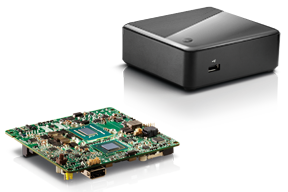
Recently, I took a different approach. I found (actually, my client found) an incredibly small computer to be our server. Just as high-precision GNSS receivers are getting smaller and smaller, so are computers. The Intel Mini-PC measures 4 inches x 4 inches (10.16 x 10.16 centimeters) and has no hard disk. It uses solid-state drive (SSD) memory for storage. SSD technology is still somewhat expensive ($1+ per gigabyte), but it is small compared to a classical disk drive, and doesn’t have any moving parts. Furthermore, the Mini-PC has ethernet ports: when we connect a network cable to it, we could access the Mini-PC via Remote Desktop. That meant we didn’t need a keyboard or monitor. The Mini-PC had all the power we needed, and we could load any sort of control software on it because it runs the standard Windows 7 (or 8) operating system. Last but not least, the Mini-PC costs only $149. However, you need to add memory, SSD, and so on, so the real cost is ~$400 depending on your configuration. While not cheaper than similarly performing “boxes” available, it’s certainly one of the smallest.
Intel Mini-PC Measuring 4″ x 4″
In fact, it’s so small that we stuffed it inside a 14” x 12” electronics enclosure box along with the RTK GNSS base and other network equipment, and hung it out of sight on a closet wall. No desktop space required. Without stretching your mind much, you can see where desktop computing is headed; very small and inexpensive enough to be dedicated to specific tasks. Think about this and then consider the Internet of Things concept. It’s very exciting.
More RTK on Mobile Devices
Later this week I’ll be experimenting with RTK on mobile devices with the CRTN (California Real Time Network), a collection of 330 RTK bases located throughout California. I’ll be using a Panasonic ToughPad running ArcGIS Mobile (and maybe ArcPad) and an iPad using a cloud-based mapping service. The latter is particularly interesting because there are lots of cloud-based GIS data collection apps on the market and under development. Specifically, there’s a lot of subscription-based, cloud-based software. The challenge is that they are even less geodesy-intelligent than the “professional grade” GIS data collection software on the market. In other words, they read coordinates (NMEA format) from GNSS receivers and feed them directly into their app. No datum transformations are provided, neither horizontal nor vertical. That’s going to be a problem.
FCC Levies Record Fine Against Chinese Supplier of GPS and Mobile Phone Jammers
The Federal Communications Commission (FCC) announced that it plans to issue the largest fine in its history against C.T.S. Technology Co., Limited, a Chinese electronics manufacturer and online retailer, for allegedly marketing 285 models of signal jamming devices to U.S. consumers for more than two years. The FCC plans to levy a $34.9 million fine against CTS. The FCC reported that CTS sold 10 high-powered signal jammers to undercover FCC personnel.
The FCC is asking people to report the sale or use of an illegal jammer by contacting the FCC Enforcement Bureau through the FCC online complaint portal, or by calling 1-888-CALL-FCC (or 1-888-225-5322). To voluntarily relinquish a signal jammer, e-mail [email protected]. Additional information, including the FCC Consumer Alert on the jamming prohibitions and the FCC Enforcement Advisory to retailers regarding the marketing of illegal signal jammers, is available at www.fcc.gov/jammers.
You can view the FCC enforcement action against C.T.S. here.
Satellite Launch Pads are Warming Up
Two GPS Block IIF satellites, one launched in February and one launched in May, were set healthy in the past three weeks, making a total of six IIF GPS satellites in orbit broadcasting on three civil frequencies; L1, L2C, L5.
On July 31, the seventh GPS IIF satellite is scheduled for launch, followed by an October 2014 scheduled launch of the eighth GPS IIF satellite.
On June 14, Russia launched a GLONASS-M satellite. It has not been set healthy yet. There are a total of 24 healthy GLONASS satellites in orbit. You can check the current status of GLONASS satellites here.
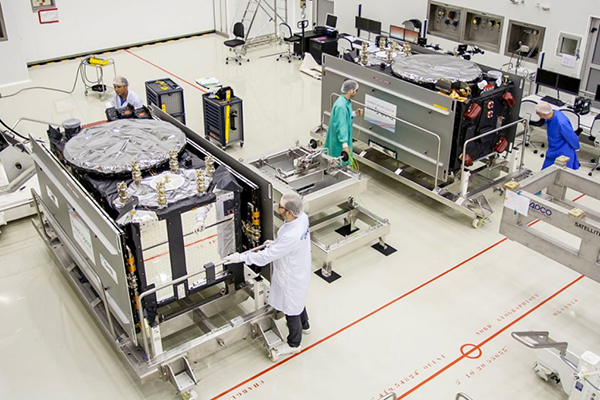
On August 22, Europe is scheduled to launch the first two Galileo FOC (Full Operational Capability) satellites to add to the four test satellites in orbit that will be integrated into the final operational constellation. A second pair of Galileo satellites is scheduled for launch in November 2014. These are projected dates and subject to slippage.
Galileo Satellites in the Clean Room
Live Webinar from the Esri International User Conference on July 17
In a GPS World first, we’ll be producing a live Webinar from the Esri International User Conference next month on Thursday, July 17 @ 10 am Pacific Time in the exhibit hall at the San Diego Convention Center. Of course, the webinar will be focus on one of the hottest topics, high-precision GNSS on mobile devices; from iPads to Android tablets to smartphones.
Tune in or join us live from the exhibit hall floor! Register here.
Most of you will know that during summertime I can usually be found in Calgary, Alberta — the “GPS Capital of Canada.” I usually try to pick up on developments in this area, and having recently bumped into my friends at Baseband Technologies, I found that they have made significant progress since the first time they appeared in my articles a number of years ago.
Baseband has now been around for 10 years, and has always focused on building reliable applications which are an adjunct to basic GPS, improving performance for integrated GPS in cell phones and other portable devices such as personal location watches, glasses, tracking devices, and such. Cell phones, of course, have had integrated GPS for a long time for personal navigation and 911 location.
Baseband aims to provide “instant position” with extremely low-power, low-cost positioning technologies. The company has several patents well into the approval loop, and have drawn heavily on the GNSS-rich’ availability of skilled people in and around Calgary for its significant R&D.
Baseband’s first product offering is a self-contained GNSS RF front-end that enables capture of satellite signal data for its cloud-based snapshot positioning receiver. The software receiver kit allows integrators to readily build prototypes that integrate Wi-Fi, Bluetooth, Ethernet, cellular modem, MEMS sensors, memory, and LCD that is compatible with the Arduino open-source electronics prototyping platform to quickly test and validate new product concepts. The snapshot receiver can also be integrated with other OEM hardware to greatly improve time-to-first-fix (TTFF) and power consumption. For customers who want to integrate snapshot positioning into silicon at the chip level, or into other hardware or software, Baseband offers system design services and a simple licensing scheme.
Nevertheless, acquiring satellites can be somewhat of a delicate operation for regular GPS receivers, and this can be especially true when a receiver is operating downtown where open sky can be intermittently blocked by buildings. The net effect is that a receiver could take a long time to calculate position, or sometimes even fail to provide a position altogether. Time is money, or in the case of cell phones, battery power is everything. So reducing power consumption and TTFF is something that a lot of OEMs are interested in achieving.
Turns out that pulling ephemeris or satellite location from satellite data can be the real issue, as the data rate of the satellite for this information is so slow. To get an initial position from four satellites could take between 16 and 36 seconds under best-case conditions — normally in a downtown core or dense forest this ideal situation is rarely achieved, and acquisition times can be much longer and become a real problem for users. Imagine how frustrating it could be for people like taxi cab or delivery trucks drivers operating downtown, where users have to constantly operate in harsh environments and may be subjected to loss of position data due to ephemeris renewal many times during a day.
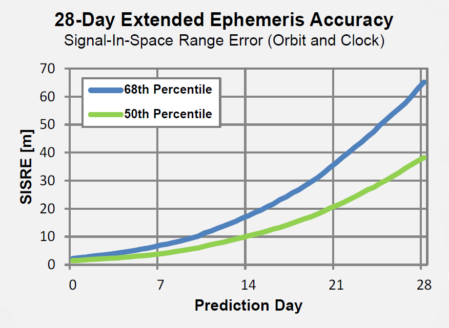
Depending on the receiver that you’re using, satellite ephemeris may only be valid for up to four hours, whereas Baseband’s extended ephemeris can last for up to one month and still maintain acceptable accuracy. This means once you’ve downloaded an extended ephemeris file, there is no need to download it again for another month. Instead of relying on receiving ephemeris from satellite broadcast and suffering through its limitations under poor conditions, extended ephemeris (or satellite prediction) technology offers several advantages.
With extended ephemeris, a satellite’s ephemeris is always usable regardless of data errors and gaps in the actual transmitted satellite data. In other words, satellites that the receiver can still see, but which have low signal strength, may nevertheless be used to go directly into acquiring the lower power satellite signal, generating the Doppler and code phase, and ultimately proceed to the position calculation. So Baseband has developed and is marketing 28-Day Extended Ephemeris service to address these problems.
For a regular embedded receiver working with 28-day Ephemeris, Baseband claims to reduce TTFF from 30-60 seconds down to around 2 seconds. Even in intermittent satellite signal conditions, acquisition or reacquisition isn’t necessary, so signals can still be used for tracking. Ephemeris transmissions to the device are extremely compressed, and can be as small as 20 KB per week, while accuracy is maintained. Baseband claims its patent-pending techniques provide unparalleled orbit and clock accuracy, which allows users to obtain highly accurate predictions. Client software for the user device is platform independent and has been designed from the ground up to operate extremely efficiently with low-power processors.
So there we have it — a new approach to achieve very fast initial position for portable digital devices including cell phones and a method to overcome lengthy initial position determination under poor signal conditions, with the added bonus that power consumption is also greatly reduced.
For high-volume commercial applications where GNSS performance is important, but conditions may be far from favorable, Baseband may well have something which could really improve how OEMs take advantage of more reliable position determination with longer time between battery recharges.
The 30th Space Symposium offered a lot to see and do.
I have said before and will undoubtedly say again, there is absolutely no space-related event in the world today that approaches the sophistication and professionalism of the Space Symposium held annually in Colorado Springs, Colorado, at the five-star Broadmoor Resort. The Space Symposium, carefully engineered and meticulously overseen by the Space Foundation, is truly the premier, must-attend space event of the year on a global basis.
I have been honored to attend 27 of the 30 symposiums, and I hope to attend many more before I shuffle off this mortal coil. Believe me when I say this; it is not merely an oblique reference to health issues. I was hospitalized for four days afterwards with exhaustion among other issues, and the chairman of one of the key companies in space today now has walking pneumonia. So, while this is a major event, you can overdo it, but that is a personal issue and not by any means the fault of the Space Foundation or the event sponsors. Instead, it is an affirmation of the quality and necessity of the event. Indeed, the Space Symposium, with an average attendance of 9,000+, has grown to the point that a single individual just cannot take it all in. It is just not physically possible, whether you are 25 or 65 — believe me, I tried.
Therefore, planning your time at the Space Symposium is essential. Unlike many symposiums where you are able to “play it by ear” and take events as they come, at the Space Symposium if you don’t plan well you will truly miss some crucial space-related event. Plus, it is difficult to relate the quality of the networking opportunities. You have access to space professionals and company VIPs at the Space Symposium that you would never be able to contact in normal daily business circumstances, and the beauty of it is they don’t have an office to escape to. There are so many additional cultural and social events that most VIPs attend, so if you don’t contact your target company VIP, it is probably just for lack of trying. Having said that, it is always good to have your elevator speech polished, because your quantity of time may be limited. You must take advantage of every opportunity. And no matter how well you plan, there are always those chance encounters, which is one of the aspects that make the Space Symposium so worthwhile. Sometimes just the opportunity to rub shoulders and discuss space matters with other professionals is all that’s required; those opportunities were abundant at this year’s symposium.
May Day versus April Fool’s Day
This year circumstances prevailed, and the 30th Space Symposium was held 30 days later than normal. The events that led to that scheduling change are significant in their own right. For instance, I will list just a few events and names; they might initially seem random, but they are intricately related:
Phil Anschutz
Broadmoor Resort
Construction
Renovation
Colorado weather
School schedules
Graduation dates
Space legislation
Sequestration
Colorado governor
Ambiance
Consistency
Education
OK, the list could go on and on, but the point is that the Broadmoor Resort, as a resort, has been around since 1918, or 96 years. The property history actually goes back as far as 1871 and the founding of Colorado Springs by Spencer Penrose, but that is another story for another time. The most recent important facts are that in October 2011, Mr. Philip Anschutz, a local Denver-based billionaire, purchased the Broadmoor, a place he fondly remembered from his childhood. He decided that it needed renovating in the best style of the early 1900 Italian Renaissance — which was always reflected in the older resort buildings on the eastern side of the lake, but was not reflected in the newer western side, with a lack properties. Consequently, the two-plus-year renovation certainly impacted the dates and availability of rooms and services available for the annual Space Symposium. In 2012-13, the event took place in spite of construction, but the 2014 date needed to be moved from April to May to ensure all facilities would be available. Indeed, the formal completion and grand opening after renovations took place was on the Friday preceding the Sunday opening of the Symposium. But then, close only counts in love and horseshoes.
So this accounts for a few words on the list, but the rest are definitely related to the conference itself. For years, many of the non-Colorado space companies and sponsors of the symposium wondered aloud if the second week in April in the foothills of the Rocky Mountains might be a bit early for such an event, since it invariably snowed, usually more than once, on participants sometime during the week-long event. However, the Space Foundation held firm on the dates for many reasons, one of which was the belief that flatlanders just don’t understand that the foothills of the Rocky Mountains are eligible for snow 12 months out of the year. Seriously, we have lived here for going on 25 years now, and we always said we were eligible for snow 11 months out of the year until a couple of years ago, when it snowed ten inches in August. It had been 80+ degrees the day before. So the Space Foundation pretty much ignored the clueless flatlanders and stuck to their guns on the date issue.
But, in all honesty, there is much more to the date debate. The Space Foundation prides itself on education and fostering interest in all things space related. It helps fund numerous space-related institutions, scholarships ands organizations. The future of space and our national heritage as it relates to our future space professionals is a consuming force in the Space Foundation’s mission. In May, most schools in the Rocky Mountain region have been dismissed for the year, and quite frankly, as they discovered this year, the space symposium is significantly diminished if the students, teachers and professors cannot attend. This year the attendance was down almost 2,000 attendees, from 9000+ to 7000+, simply because schools and educators from grade school to graduate school found it difficult to participate. Be that as it may ,the Space Foundation could not ignore Philip Anschutz and the multimillion-dollar Broadmoor renovation, nor the major inconvenience to the guests and attendees. So they reluctantly agreed to move the date to May as a one-time experiment.
The results of that experiment were definitely mixed. On the plus side, the renovations were complete and the transformation was phenomenal — if you had never visited the Broadmoor before, you would not be able to tell anything was changed. Facilities and buildings on both sides of the lake look like they were built in the early 1800s, but with all the modern conveniences of the 21st Century — a truly amazing accomplishment and tribute to Phil Anschutz’s vision. I visited the Broadmoor at least once a month during the two-year renovation, and I was still amazed at the transformation. Nineteenth-century Italian ambiance and 21st-century convenience, what a combination.
Now to the weather. Indeed, there were only a couple of small snow showers in the early morning hours during the week at around 0500, which most everyone missed. But Wednesday’s monstrous mega-hailstorm happened in the middle of the afternoon and was not to be missed, visually, aurally or physically. I was enroute to a meeting with Dr. Mark Crews and company from Ball Aerospace on the East side of the lake when the meteorological freight train struck. Fortunately I was under a huge Broadmoor umbrella at the time, or would have surely suffered a concussion, and that is no exaggeration. Golf-ball-sized hail appeared in biblical proportions (Moses would have been proud), and insurance companies executives, many who were in attendance, could be seen talking rapidly on phones and groaning visibly. Indeed, USAA, my insurance company for the last 50+ years, reported more than 800 automobile and 400 property insurance claims in a 24-hour period following the storm, and many insurance companies sent in their disaster and catastrophe teams. So, all in all, I vote for the occasional light snow in April versus the icy rocks raining from heaven in May. I know it is an anthropomorphic illusion, but it is as if Mother Nature were thumbing her nose at those flatlanders who dared be critical of a few snowflakes in April. On the plus side, the added moisture ensured the fireworks display could take place as planned this year, and it is always a spectacular event over the Broadmoor Lake.
Politically Speaking
Politically, the timing could not have been better for the Governor of Colorado, the Honorable John Hickenlooper, who came south of the Mason-Dixon line and attended the event where he ceremoniously signed significant Colorado State tax legislation that — bottom line — makes it more profitable for all space-related companies to operate in Colorado. Colorado currently ranks third in the nation for space-related income. Many believe it will return to the Avis, or number-two, spot that it held for many years, after this legislation has time to take effect. Current rankings are California first, Florida second, and Colorado third.
Social Events
And last but not least, let’s not forget about the entertainment and social gatherings. There are more breakfasts and luncheons than you could possibly attend. Of course you have to be invited, but if you have something somebody wants, the invites flow. The evening dinners and some social events are much more restricted in nature, but are in truth where much of the real “marketing” and work — read deals — are accomplished.
This year just as last year there is one event that stole the show. Strictly invitation only — last year only 200 select individuals were invited, and this year although the number doubled (word got out), it was still very much the exclusive event. I am speaking of highly coveted invitations to the Connecting Colorado Gala hosted by Braxton Technologies at the Cheyenne Lodge at the Broadmoor, several miles from the main event. There were CEOs, company presidents, CFOs, politicians and wanna-be senators and congressmen. A small chamber music group played quietly in the background, and you could actually talk in a normal tone of voice and be heard. Delicious delicacies streamed out of the world-class kitchen for hours. There were huge roaring fireplaces on the wrap-around deck, lit with torches, and of course lugubrious cigars, champagne and other fine wines and brandy in abundance. The weather cooperated and the stars put on a fine show. Security was clearly evident, and it worked. Because parking is extremely limited and buses provided the majority of the transportation, you could not board the bus without an invitation. There were no gatecrashers at this event. As my highly prized pass to the event clearly stated — Non-Transferrable — some names were checked against photos at the door. It was truly a classy evening, one that will be long remembered and one that absolutely works from a networking point of view, and if you are not networking, then why be there? My hat is off to the O’Neil brothers, Kevin and Kenny, as well as their CEO Frank Backes. It was a class act, the place to be, and they literally showed every other company at the symposium how it should be done.
We haven’t even discussed all the announcements and events that took place at the 30th Space Symposium, and yet if you were there, you saw seamless million-dollar renovations at a major five star resort, all of your closest buddies in the space world, as well as VIPs you have been trying to get in to see for years, and meteorological and man-made fireworks second to none — along with networking opportunities that frankly only occur once a year at this prestigious event.
I was able to meet with and have lengthy conversations with many VIPs from major space companies, and there are some exciting announcements to come. Believe it or not, some companies want to get out of the government space business — frankly, seques-castration has scared them away. They no longer want to bet the future of the company on congressional budgets. Certainly understandable. Then there are companies that have been out of or momentarily unsuccessful in the GPS/PNT business and are anxious to get back in the game. There are groups of companies that briefed me on proposals that will simply amaze you, and be assured I am doing my best to obtain permission to write about those opportunities. These stories and conversations with VIPs are just too important to give short shrift, so I will be reporting on them in future columns.
Now let’s address the huge shift in Who’s Who in Military Space. The national military space landscape is changing dramatically and is being led by the imminent retirement, in August, of my long time friend and colleague General William Shelton. Willie will retire in the Colorado Springs area and be replaced as the Commander of AFSPC by Gen (S) John Hyten, who I have also had the pleasure of knowing and working with for the past 20 years. Indeed, almost all the major space players in Air Force Space Command and at SMC are changing and those that remain are in the most part good guys, like Colonel Wild Bill Cooley and Mr. David Madden at SMC who understand this business and can be trusted to do the right thing. However, be advised the changes are still pervasive. A friend emailed me just this week and asked me for info on all the significant changes in the Command that I knew about, that affected the continuity of the national security space mission. Just off the top of my head, I came up with 14 moves and retirements — so you get the point.
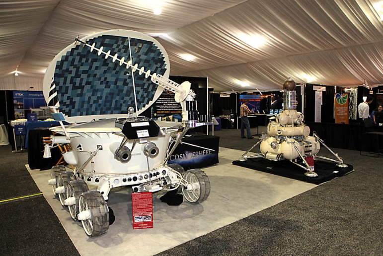
A Lunokhod Rover from the Kansas Cosmosphere and Space Center on display at the Space Symposium.
One of the major changes concerns the GPS IRT (Global Positioning System Independent Review Team), which John Darrah and I co-founded in the Chief Scientist Office at HQ Air Force Space Command just over 19 years ago in May. We decided that in order to operate totally independently, the IRT needed to be administered by a truly autonomous organization, so the IRT was designated to be tasked by the commander of AFSPC. For a time, this was the Undersecretary of Defense for Space through the auspices of an FFRDC (Federally Funded Research & Development Corporation) think tank, known as the Institute for Defense Analyses or IDA. During the last 19 years the IRT conducted studies and helped solve thorny space issues, mostly related to GPS and PNT, for eight commanders of Air Force Space Command and for key officials in the Department of Defense. Our first chairman was none other than the late Dr. James Schlesinger, who previously served as chairman of the Atomic Energy Commission, director of the CIA, U.S. Secretary of Defense, and the U.S. Secretary of Energy. He also served and advised eight presidents, and at the time of his passing was serving (since 2007) as the chairman of the National Space-based Positioning, Navigation, and Timing (PNT) Advisory Board. The PNT Board is composed of recognized GPS experts from outside the U.S. government that advise the deputy secretary level PNT Executive Committee in its oversight management of the GPS constellation and its governmental augmentations.
No sooner was the IRT formed under Dr. Schlesinger’s leadership than it was given a non-GPS or PNT-related task, and it proved to be a major task indeed. The task was to form a Broad Area Review panel for space launch and determine why the U.S. had, over the period of a few months, put more than $4 billion worth of space hardware into saltwater versus the vacuum of space. Since that original and subsequent BAR, the U.S. has not had a single complete launch failure in over 120+ launches, a record that cannot be claimed by any other space-faring nation and testament to the value of world-class, truly independent review teams that tell it like it is, warts and all.
Dr. Schlesinger represented the caliber of people that serve on the IRT, which still exist today as an independent panel led by Major General (USAF, Retired) Robert Rosenberg under the auspices of the Independent Strategic Assessment Group, also administered by IDA and chaired by former Chief of Staff of the USAF and former head of IDA, General Larry Welch (USAF, Ret).
The landscape and leadership are changing, but the National Security Space mission remains the same. Hopefully the national leadership will be able to adapt and perceive the current changes as opportunities – because while brilliant and intelligent leaders matter, people matter. Success should never be about personalities but rather about integrity, professionalism, and dedication – about doing the right thing and making the right decision every time.
What Is Don Reading?
This month I only have room for one important tome: Lindbergh by A. Scott Berg.
I initially read this wonderful volume several years ago and enjoyed it very much. I read it again recently because of the Time and Navigation display at the Smithsonian that piqued my interest in all things related to time and navigation through the ages. Lindbergh’s first solo flight across the Atlantic Ocean was not a flight of fancy, but rather a flight of daring as well as one of historical significance from a world-class aviator. He did not take any over-water navigation classes until after the event! As the jacket states, “…here at last is the definitive life of one of the most legendary, controversial, and enigmatic figures in American history.” I hope you enjoy it as much as I did. Highly recommended.
Until next time, happy navigating, and please make your plans now to attend the 31st Space Symposium in 2015. I hope to see you all in Orlando, Florida, at the ION JNC (Institute of Navigation Joint Navigation Conference) event later this month (June 16-19, 2014).
Three weeks ago, GPS World / Geospatial Solutions held a webinar highlighting new technologies for imagery and data capture. The webinar had four presenters: Paul Smith of CycloMedia, Ted Ralston with Soft Power Solutions, Peter VanAmburgh from IIF Data, and John Ciampa CEO of Alta. You can view a YouTube video of the session. Because webinar time is limited, we couldn’t cover the technologies in detail, so I’m covering some of the technologies one column at a time.
In February, I devoted my column to CycloMedia, so you may want to review that material if you want more detail. This month I want to delve into the Alta balloon system that was presented by John Ciampa, the CEO of Alta. John was the original patent holder of Pictometry, the revolutionary high resolution geo-referenced metric oblique imagery system. He and Steve Schultz took the concept from theory to a practical functioning system that has been an industry standard for over 10 years.
John continues his research, dividing his time between the Rochester Institute of Technology (RIT) and Florida International University (FIU) while also working with the National Science Foundation (NSF). Although Pictometry was very successful, he also understood the limitations and cost of a manned aircraft as a capture system, especially for disaster response. Pictometry was a very capable system, but John felt that what was needed was a system that had a “lighter footprint” figuratively and literally. John took his knowledge and experience, and combined it with the latest developments in micro-miniaturized technology, to develop a system that was elegant in its simplicity and usefulness.
The Platform
Simply put, the Alta balloon is a steerable oblique geo-referenced camera system attached to a weather balloon. By using a balloon, John solved several problems associated with manned aircraft — cost, image quality, and accessibility. A balloon is cheaper than an aircraft, doesn’t require a licensed pilot, is more easily deployable, and can “fly” at lower altitudes.
Even a small aircraft is expensive, and requires a trained pilot and complex support logistics. A small used aircraft can run $50,000 to several hundred thousand dollars. Additionally, most high-end aerial imagery systems generally require expensive FAA-approved modifications of the airframe. This adds cost, and limits the aircraft that can be used. Equipped with Pictometry cameras and electronics, a total aircraft capture system can easily cost $300,000 and up.
A significant factor during disaster response events is transportability and support. Past experience has shown that it can be very difficult to transport and operate even small aircraft in disaster regions, especially if the damage is widespread. Fuel and ground support in disaster sites can also be a serious limitation. By comparison, a balloon system can be carried in a suitcase, shipped quickly, and set up in less than an hour. Since the cost is in the range of several thousand dollars, multiple systems are practical and can be deployed in numerous remote locations. Equally impressive is that operators can be trained in less than an hour.
But don’t get the impression that Alta is as simple as strapping a digital camera to a balloon. Achieving the image quality, accuracy and dynamic performance of the Alta system requires a very sophisticated package, including the balloon, controls, communications and sensors. The balloon system is actually two balloons, one within the other, an outer balloon and inner lift gas balloon. The outer balloon provides some external protection while presenting a consistent profile. The inner balloon provides the lift and is filled with either hydrogen or helium.
The altitude is remotely controlled by venting lift gas to descend or by dumping water ballast to ascend. An onboard computer and sensors can also maintain altitude autonomously. When the balloon is brought down, a tethered weight drops to several feet under the balloon. The weight contacts the ground first and “anchors” the balloon and payload for retrieval. This keeps the balloon and payload off the ground, and also makes it easier to spot.
There are several modes of operation that are determined by the operator prior to launch:
“Path Mode”: The balloon is released, ascending to the programmed altitude, then drifting with the wind currents before descending back to the ground.
“Patch Mode – single tether”: Used to launch and retrieve the balloon. The balloon ascends to altitude, and its position is downwind based on the strength of the wind acting on both the balloon and tether.
Patch mode with single tether.
“Patch Mode – multiple tethers”: Very precisely controls the location of the balloon over a limited area. This is very similar to the overhead cameras used in televised football games but in reverse, since the balloon wants to fly up.
Patch mode with multiple tethers.
The system can also be equipped with a parachute for emergency landings, a solar trickle charger for extended missions, and even a quadcopter that can steer the balloon to specific target areas. The lift capability of the balloon permits significantly longer duration flights than a quadcopter alone. A detailed operator’s manual is available for review at the Alta website — look for the Operators Manual.
The Payload
The modular payload is complex, but also lightweight and compact thanks to the latest developments in miniaturization. It consists of a precision GPS unit, inertial measurement/navigation unit (IMU), an onboard computer, environmental sensors, Wi-Fi communications, and an aimable high-resolution camera on a stabilized gimbal. The camera can be RGB, night vision or even multi-spectral. The imagery is downloaded as captured and delivered almost real-time.
Modular payload.
The Output
Because the balloon floats at low altitudes, image resolution is an impressive “game changer.” Here is just one example comparing a 4-inch pixel Pictometry/Bing image taken from 3,000 feet to a 1-centimeter pixel Alta image of the same location taken from several hundred feet.
Bing (left) and Alta images of stadium seats, compared.
Similar to Pictometry, the system uses GPS and IMUs to very accurately determine the camera location and attitude. That information, linked via algorithms to the captured imagery, results in imagery that is geo-referenced, measurable and available with full metadata, including the time of capture. I can’t over emphasize how important this is. Having instant access to imagery is nice, but having that imagery already geo-referenced means that the imagery can be quickly and easily imported into a GIS and overlaid with legacy GIS data for instant analytics.
The system has been used for many mundane applications such a real estate, agriculture, construction/engineering and event planning. More critical applications include crime-scene monitoring, surveillance and disaster response. Recently, in response to a South Florida Mall shooting, police launched an Alta balloon to view the crime-scene location. The imagery was instantly and continuously sent to police station computers and mobile devices of responders en route to the mall for pre-planning of their response. Viewing rooftops and walkways for victims and perpetrators, a near real-time operational picture was provided to police before putting themselves and others in harm’s way.
Actual image from an Alta balloon used in SWAT team maneuvers.
Dolphin Mall Sweetwater Florida, May 14, 2014, 6:05 a.m.
The Potential
I’m especially excited about the potential lifesaving use of Alta balloons. On numerous occasions I was involved in emergency response actions, and the dominant overarching need was high-quality imagery that could be combined with legacy data and imagery as close to real-time as possible. This system answers that need, and at a low cost. I could envision several Alta systems in every county nationwide ready to deploy on a moment’s notice. I believe that these units would be especially valuable for disaster response in second- and third-world countries. Dozens of Alta systems and trained operators could be delivered on short notice to major disaster sites, providing almost real-time common operational pictures for first responders. The added advantage is the very light need for logistics and support.
Military applications could be equally important. The silence of balloons coupled with a small visibility profile, including almost total invisibility at night, makes them ideal for reconnaissance and surveillance. The relatively low cost of the platforms also permits them to be expendable. In a tethered mode, the persistent “eye in the sky” could serve as a deterrent, or at a minimum make hostile activity more complicated for the perpetrators as they try to hide activities from the balloon. The “light” logistics and fast operator learning curve are just added benefits.
A key question raised during the webinar was FAA control. John indicated that the FAA does not consider the Alta balloons in a tethered mode subject to their control, and is currently reviewing it in a drift mode. John further amplified that the very low altitude of operation and dual control of descent should also exempt the drifter from FAA involvement. Alta could provide a significant advantage where UAS operations are restricted or not practical.
In a recent book, “Smaller Faster Lighter Denser Cheaper” by Robert Bryce, reviewed in the Wall Street Journal, the author argues that a similar dynamic, making less do more, drives virtually every technological change that has created the modern world, from cars and airplanes to advanced medicine, strategic metals and the iCloud. Alta balloons are certainly a good example.
I was an early proponent of Pictometry because, unlike abstract GIS data and ortho imagery, the metric oblique imagery was easily understood by non-GIS users. I saw many examples where it saved lives because police and firefighters were able to form and exploit a common operational picture quickly. Alta has me equally excited because it brings that same capability to users with a much simpler system that delivers almost real-time imagery at a cost anyone can afford. This technology is going to help a lot of people.
Tony, I do take issue with the suggestion that the International GNSS Service (IGS) is somehow inferior and not reliable. I understand that Veripos is a commercial service designed for specific markets, but in central New South Wales (most populous state of Australia) it is 800 kilometers to the nearest base station.
You mention “So Veripos and other commercial providers overcome the weaknesses of IGS by providing a worldwide network that is well maintained — an infrastructure designed for high reliability and availability. Each base station has dual-redundant receiver and communications links.”
The IGS has 400+ base stations. How many does Veripos have? If a station goes down on the IGS there are still 399+ backups.
“There are three processing centers, two active and one on warm standby.”
The IGS has seven processing centers using different algorithms and combined solutions.
“There are seven geostationary satellites with a large degree of coverage overlap.”
OK, IGS is not a real-time service —yet… but some sites are.
How does Veripos handle coordinate dynamics (station velocities)?
Don’t get me wrong, Veripos looks like a very good service for its clients, but please don’t bag the IGS, which I liken to the United Nations of geodesy. Many good people and nations contribute (through their taxes which support infrastructure and personnel) to this service for the benefit of all.
Thanks for putting together this article. It’s good to know more about Veripos, and I hope to try it out soon.
Our survey editor Eric Gakstatter chimed in with this comment:
Good points. Have you used the IGS service yet? I’d like to give it a spin.
Craig Roberts replied:
Not me personally, but one of my students and some researchers have. You can download some open-source software (there are a few options) and try it out. Early days for the RT IGS but results seem encouraging. Still the standard issues with initialization times for RT PPP processing. We are also looking at the LEX message from QZSS which graces our shores thanks to the Japanese. Basically investigating near real-time positioning options for remote locations in the absence of CORS networks and/or mobile phone coverage.
Tony Murfin added:
No IGS bashing from me. IGS is a different tool of a different color. Point of the article is that if you want to run a business requiring PPP performance, you need to use a commercial service. If your application can stand some potential down-time and tolerate longer initiation times — for university and engineering R&D for instance — IGS is perfect. It’s free of charge and accurate and as reliable as you need. Good luck with IGS, it’s a great system!
Putting GNSS into use within much larger aggregates of systems shows the greatest promise yet for earthly good. Goodness knows, we have experienced plenty of benefit from GPS applied over 25+ years, from back-up and fill-in provided by GLONASS, and with further synergy anticipated from Galileo and BeiDou. But we ain’t seen nothing yet. Two presentations this month at the Geospatial World Forum in Geneva show that teamed with other, non-navigation satellite systems and the ensuing big data sets, GNSS leads the way into 21st-century illuminated knowledge and enlightened action. The European GNSS Agency supports many innovative prototypes to drive Galileo market penetration, and the International Centre for Earth Simulation envisions building a Virtual Earth to better understand the real world.
Galileo and EGNOS Seek Market Penetration
Carlo des Dorides, executive director of the European GNSS Agency (GSA), presented experience, results, and a broad call for proposals for future application developers in the “geoSMART + Infrastructure Development” plenary session of the Geospatial World Forum, held May 6–9 in Geneva, Switzerland. The GSA is tasked with market development for the European GNSS programs, EGNOS and Galileo, and its viewpoint is of necessity rosy on user uptake.
In a side note before we look at these market-development efforts, des Dorides showed a figure that I had not seen before, one which claims that signal noise from the four orbiting Galileo satellites is noticeably less than that encountered on current GPS and GLONASS combined solutions. Another piece of the portrait we began at the magazine with post-processing PPP using two Galileo GIOVE and two IOV satellites as reported here, and then using four IOV satellites to do differential carrier-phase positioning as reported here.
chart: Galileo GIOVE
The GSA has funded many small-to-medium enterprise projects, and some of these may actually take off, that is, achieve sustainability through consumer or industry payment. The double edge of stimulus spending such as this is that products may or may not be created, and corresponding business models may or may not be built, with a truly hardened eye towards cash flow. Such a product or service’s only sustainable mode may turn out to be, after all, through government funding. Nevertheless, these are valiant efforts.
To be fair, the primary goal of these projects is to get Galileo and EGNOS into more widespread use, thus encouraging manufacturers of receivers, smartphones, tablets and so on to include Euro GNSS capability in their products. Establishing self-sustaining downstream enterprises is secondary.
Emerging from three successive stages of the current framework program for R&D spending, des Dorides cited “10 Patents or registered trademarks,
33 commercialized products/services, 69 working prototypes, an overall portfolio of roughly 90 R&D projects with a budget of around €70 million.”
“And more is expected!” he added.
Among the GSA projects he singled out for further description:
SAFEPORT: Safe Port Operations using EGNOS safety-of-life services for vessel traffic management, with a successful prototype demonstration in Dublin port. SAFEPORT has been in the market since January 2013. As commercial-targeted service, or perhaps a government agency (such as a port authority)-targeted one, this may have a return-on-investment prospect.
WalkEGNOS, a social web 2.0 mapping solution with a web site following the social network approach, enabling hikers and bikers to share theirs tracks. This produces “new opportunities for high-quality leisure/ touristic services, and value for search and rescue operations.” I am dubious, myself, as to whether hikers or commercial tour services would pay for such services, but it’s certainly worth the effort (and the government money) exploring the possibility through application development. The service is now available; you must register to use (free of charge).
GOLDEN-ICE, applying EGNOS GPS corrections to enhance accuracy for precise salt-spreading for road safety. On the market.
INCLUSION, a location-based service offering motor-impaired persons, such as those confined to a wheelchair, improved mobility in safe conditions, helping them navigate traffic safety problems and limited accessibility of public transport. On the market.
Other applications available for use include ASPHALT for high-precision paving, SCUTUM for transportation of dangerous goods, and COSUDEC for surveying of coastal waters. Further programs and results are here.
The Whole Earth
In easily the most mind-blowing presentation of the conference, founder and president Bob Bishop of the International Centre for Earth Simulation spun a vision of Big Data Earth Science, using the world’s largest computing resources (talk of exoflops and exobytes and “the human mind cannot comprehend these large volumes of data” supplied by many orbiting imagery satellites and other sensor inputs) to model the Whole Earth: surface, subsurface, ocean, atmosphere, and social economics.
Earth observing satellites are generating big data sets.
The Centre’s mission is “Helping guide the successful transformation of human society in an era of rapid climate change and frequent natural disasters.”
In its prospectus, Bishop writes “The key to solving problems in weather, climate and environmental science is high performance computing. Nature can only be accurately described and computed from equations that take account of complex, non-linear interactions between multiple natural systems, i.e. rivers, lakes, oceans, mountains, forests, dust, pollution, cloud cover, snow cover, ice, polar regions, etc. Such equations of motion are so interconnected and intertwined that they can only be managed when all aspects are held in big memory and computed simultaneously. Only then can we begin to address the systemic risks associated with natural disasters and planetary change.”
The ICES Foundation supports Open Science, which incorporates a combination of open data files, open source code, and open access publications. Much of the data supplied by the following organizations, upon whose resources ICES draws, is either directly produced by or referenced to GPS/GNSS data:
Global Observing Systems Information Center and the U.S. National Oceanic and Atmospheric; the European Space Agency and Centre for Space Records; the U.S. Geological Survey; the U.S. National Aeronautics and Space Administration; the European Union’s Joint Research Centerthe U.S. National Center for Atmospheric Research; the U.S. Naval Research Laboratory; the European Commission’s Infrastructure for Spatial Information in the European Community (INSPIRE); and many more.
Bishop warned of both sequential and synchronous collapse of natural systems, leading to cascading crises. His language and message bear some resemblance to Al Gore’s An Inconvenient Truth, but Bishop, whose previous 40-year professional career had him responsible for building and operating the international aspects of Silicon Graphics Inc., Apollo Computer Inc., and Digital Equipment Corporation, has assembled some actual practical tools to apply to the many problems.
The immediate goal is modeling, simulation, visualization, and ultimately understanding of the whole, leading to new forms of civic engagement and insights as to risk, safety, food, water, and energy.