For some years now, we have been talking about GNSS interoperability. The concept has received so much careful attention at conferences, in R&D laboratories, in international working group forums, and behind closed high-level government and military doors, that one might understandably conclude that we have talked interoperability into existence.
Not quite. Not nearly. Not by the farthest, if measuring into the next decade constitutes far, reach of our actual, real-world grasp.
“If you can imagine it, you can achieve it.” William Arthur Ward, a professional inspirer of the 20th century, said that.
For nearly as many years now, we have been talking about GPS and GNSS backup. Similarly, the concept has undergone careful examination and much repeated (’til blue in the face) urging and warning and alarum-
sounding and planning and conjecturing and running through the halls of Congress. One might understandably conclude that we have conjured backup for critical infrastructure into actual, tangible, effective existence.
Again, not quite.
“Everybody talks about GPS backup, but nobody does anything about it.” Mark Twain said that.
April’s GLONASS downfall prompted distinguished industry leaders to again take up cudgels for multi-GNSS and for redundant PNT. They deserve and require our support, on all fronts, whether in the public arena, the lab, or the marketplace. But neither concept yet exists, truly and pervasively, that is to say effectively for all users.
When will reliable, robust, consistent and continuous positioning, navigation, and timing become a reality? Should we rely on whatever technology we currently possess until the perfect system comes available, or should we continuously upgrade at each iterative step along the way?
We take up this topic in our June 5 webinar, “How Much Farther to the Promised Land? Purchase Decisions in the Evolving Landscape of GPS, Multi-GNSS, and Alternative PNT.”
Four speakers will present:
a high-precision GNSS manufacturer,
a mass-market GNSS manufacturer,
an alternative PNT provider,
a design and manufacturing firm,
followed by questions from you, our audience. Come for a glimpse into the future, and estimations of its distance and time of travel from current location.
Among the key insights: technology changes too fast to wait until the next generation of a product to add new capabilities, when doing so risks loss of competitive edge or, worse, risks introducing a new product already obsolete. A mid-lifecycle component change can deliver both greater performance and cost savings. For details on this prior to June 5, visit the White Paper section of our website.
The North Sea fairly boils with GNSS activity recently. Trials of the eLoran back-up for GNSS, Galileo maritime trials, Brad Parkinson’s Protect, Toughen, and Augment sermon at the European Navigation Conference in Rotterdam, and also at that conference, the dramatic release of news concerning an even newer Loran system, enhanced differential Loran, that not only backs up GNSS in the event of disruption or jamming, but delivers 5-meter accuracy in the process. Imagine that — the back-up matching the first team in performance!
Durk van Willigen, René Kellenbach, and Cees Dekker of the Dutch consulting firm Reelektronika, and Wim van Buuren of the Dutch Pilots’ Corporation authored the ENC presentation about enhanced differential Loran, with results that greatly — and pleasantly — surprised many in the audience. A full technical article by these authors, describing the equipment, methodology, and test results of eDLoran, will appear in the July issue of GPS World. This column delivers a brief summary of the highlights.
The new Loran project arose from the need of harbor pilots responsible for bringing large and super-large freight ships into dock. These pilots require GNSS-level accuracies of 5 meters for such work, and all parties concerned — pilots, captains, ship owners, harbor management — need some form of robustness, that is, back-up for the GNSS systems in case of jamming, unintentional interference, system failure, or other disruption.
As extensive research had established that 5-meter accuracy cannot be met by the currently tested DLoran system, which cannot get better than 10-meter accuracy. Reelektronika developed a new differential Loran system called enhanced differential Loran, or eDLoran. A full prototype eDLoran system was built and extensively tested in the Europort (Rotterdam) area. The tests achieved accuracies of 5 meters.
For maritime applications, eLoran is considered as the most promising backup for GNSS in case the use of satellite-based navigation signals is denied. The Dutch Pilots’ Corporation askedReelektronika to investigate whether differential Loran could meet the pilots’ 5-meter accuracy requirement for a harbor navigation. This proved to be an enormous challenge as preliminary tests showed that even 10 meters was difficult to achieve with differential Loran (DLoran) as promoted by the UK’s Trinity House/General Lighthouse Authority (see item below about Harwich UK tests by GLA and ACCESS). The challenge had led to a thorough investigation of all possible error sources of a complete differential Loran system.
Differential techniques developed and implemented for Loran are comparable with differential GPS. Although the error sources of GPS and Loran are quite different, the major common error source in both systems is the lack of accurate propagation models.
This led to a new research project to find a more accurate differential Loran technique. All possible error sources have been investigated again where possible, which resulted in some unexpected results regarding accuracies and costs.
Enhanced Differential Loran: eDLoran
The new concept of differential Loran had to fulfill two important primary improvements. The first is a significant reduction in the latency of the data in the data channel; the second is that a large number of reference stations should be capable of receiving the data channel, without saturating the data channel. The simple conclusion was that Eurofix could not meet these two improvements. However, Eurofix is still the prime GNSS backup candidate for distributing accurate UTC over very large parts of Europe. Further, Eurofix has the capability to send short messages that might be encrypted for secure communication purposes which might then form a terrestrial backup, for example, Galileo PRS.
Instead of using the Eurofix channel, eDLoran uses the public mobile GSM (Global System for Mobile) network to send the differential corrections to users. eDLoran receivers therefore contain a simple modem for connection to the GSM network. The eDLoran reference stations are also connected to the Internet which may be implemented via a cabled access or also via a GSM modem.Fortunately, today many GSM networks are robust in respect of GPS outages.
The eDLoran infrastructure is not connected with any eLoran transmitter station and operates completely autonomously. An eDLoran reference station is connected to a central eDLoran server by its connection to the network.
eDLoran Results
Both static and dynamic tests have been carried out. Here, only the final result of the dynamic test is presented. For full details on both sets of tests, see the upcoming full-length technical article in the July issue of GPS World magazine.
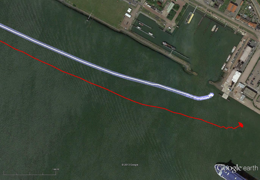
The results have been demonstrated to the harbor authorities in real-time on the laptop of the pilots on which the GPS-RTK and the eDLoran position were simultaneously shown. The logged GPS-RTK data is plotted on a Google Earth map shown in the accompanying figure. The track was widened to 10 metres as the accuracy requirements are 5 metres on either side of the track. The raw eLoran track is also shown, as well as the final white eDLoran track.
The red track is based on raw eLoran data without any corrections. The transparent blue line is made by GPS-RTK and is widened to 10 metres giving the required ± 5 metre limits of eDLoran. The white line is output from the eDLoran receiver which stays within the borders of the 10-meter-wide transparent blue line.
Conclusions
The outcome of the research opens some new and quite surprising possibilities for multiple applications. Only a few of the authors’ conclusions appear here:
eDLoran offers the best possible eLoran accuracy as it does not suffer from swaying wire antennas, sub-optimal timing control of the transmitter station and differential data latency.
There is no need to replace older Loran-C stations with eLoran transmitters saving large amounts of money. The existing Loran stations have a proven reliability track record. Further savings may be obtained by containerising the transmitter and operating the stations unmanned.
Installing eDLoran reference stations is fast, simple and very cost effective.
As there is no data channel bandwidth limitation, multiple reference stations can be installed which offers increased reliability and makes the system more robust against terrorism and lightning damage.
A single or multiple eDLoran servers can be installed in a protected area. There is hardly a practical limit in the number of differential reference stations to serve.
To round out our North Sea reporting, here is other recent news:
Enhanced Loran
In March, the UK General Lighthouse Authority (GLA) and Accessibility for Shipping, Efficiency Advantages and Sustainability (ACCSEA) announced that on several excursions aboard the THV Galatea out of Harwich, UK, they successfully demonstrated a prototype resilient positioning, navigation and timing (PNT) system using enhanced Loran (eLoran) technology to automatically and seamlessly step in to transmit mission-critical data in the event of GPS loss or failure. (Note that in the preceding Reelektronika section of this column, the GLA enhanced Loran is referred to as differential Loran, while the Dutch system is called enhanced differential Loran.)
Building on two previous trials conducted by the GLA in 2008 and 2010 which investigated the impact of GPS service denial, this latest demonstration is the first time that an automatic and seamless solution has been demonstrated in a real-world scenario. The prototype system was integrated into the bridge of the vessel and monitored the performance of independent PNT sources in order to provide the ‘best’ available. As such, when GPS was deliberately jammed, the system switched automatically to eLoran and provided eLoran-derived PNT information to the connected bridge systems, allowing them to maintain operation and enabling the mariner to continue to navigate safely and efficiently.
ACCSEAS is taking advantage of the availability of the prototype eLoran transmitter at Anthorn and eight other Loran stations around the North Sea Region, but few vessels currently have receivers. Most recently, in January 2013, a differential Loran station was installed at Dover, UK, one of the busiest shipping lanes in the world, enabling mariners to obtain port approach level accuracies using eLoran within this area; and a receiver was fitted on a P&O Ferries vessel. The successful demonstration of the prototype resilient PNT system is a significant step towards gaining traction for the technology in the shipping industry worldwide.
By 2014, eLoran Initial Operational Capability is expected in seven major ports along the East Coast of the UK, with full operational capability covering all major ports expected by 2019.
Galileo Maritime Trials
Results are being processed from the first Galileo maritime trials outside of mainland Europe. The long-range, high-latitude testing spanned the North Sea aboard Belgian frigate Leopold I-F930, carrying multiple Galileo receivers for both Galileo’s public Open Service (OS) and secure Public Regulated Service (PRS).
Protect, Toughen, Augment GNSS
“What can we do to reduce the vulnerability [of GPS] and ensure that the expectations of the public are going to be met?” asked Dr. Bradford Parkinson as he opened his keynote presentation at the European Navigation Conference, ENC-GNSS 2014 in Rotterdam, The Netherlands.
Parkinson went through his 61-slide, 50-minute briefing on what he called “PTA” — Protect, Toughen, and Augment — a proposal concerning not only GPS but PNT systems globally. An article by Parkinson based on this talk will highlight the special 25th Anniversary edition of GPS World, to appear in conjunction with this year’s July issue. A brief outline appears here.
Facebook Nearby Friends feature helps people get together.
While Facebook has made big news buying companies for billions of dollars, it hasn’t been making many location-based services headlines. The recent announcement that it is rolling out a friend finder is interesting news, not only for social applications, but the potential indoor positioning markets. The news is also interesting because as many as half of Facebook users access the social media network through mobile devices.
Signaling that it does have a location strategy, as GPS World reported earlier this week, Facebook announced that it was launching an LBS offering called Nearby Friends. The opt-in service allows users to find out what friends are nearby or mobile.
Nearby Friends will be available on Android and iPhones in the U.S. market this month. In Facebook’s press announcement, apparently privacy is a big issue as the company insists it is an opt-in function.
Once users agree to use the service, they will be notified when friends are in close proximity. Users can select the friends who can see their location — and can turn the service on or off at any time.
At first glance, Nearby Friends could be a valuable tool for users looking to find friends and make plans, but the real potential could be for retailers who wish to drive in-store traffic. Users can not only invite friends to a specific business on a map, but tag other traffic.
The area or business to where the friends are traveling will be displayed on their profile. This allows the friends who opt in to recommend shops, restaurants and other things to do in the specified area.
How retailers get their message out to Nearby Friends users remains to be seen. Research company Berg Insight still says advertising will constitute the main revenues for social networking and local search market segments. However, in several published reports, users have tired of the increased Facebook advertisements.
Berg says that social networking and entertainment has now overtaken mapping and navigation as the largest location market. The company says that those services include general social networking, messaging apps, friend finders such as Nearby Friends, and games.
While Facebook could use the Location History in Nearby Friends to make money selling ads, the company says it isn’t right now. But it has to be the future — and one that, privacy issues aside, could be very lucrative for the company. It could target opt-in users with ads that are only a few feet away or in the area they will meet friends.
The Wall Street Journal reported that Facebook will leverage its user base, estimated at one billion users, to improve ad targeting, expand marketing reach, and to make more money. The company earned $1.24 billion in revenue through mobile ads for the last three months of 2013, according to published reports.
After the announcement that Facebook was launching Nearby Friends, a number of tech business articles sprung up about potential, real and imagined, privacy issues. With the predictable privacy issues comes opportunities for location startups. A new location app is touting itself as the “anti-social networking” tool. Called Cloak, and available in Apple’s App Store, it allows a user to avoid friends they want to avoid by revealing the location of contacts — while keeping the user’s position hidden.
The app, which already has been downloaded more than 100,000 times, uses Instagram and Foursquare data, and published reports say Facebook compatibility is coming soon.
Rumors about Acquisition Prove False?
Earlier this month, several tech business industry publications wrote that Israel-based indoor navigation startup ShopCloud was in talks with Samsung to sell the company for as much as $90 million. Samsung has denied the rumors.
In articles like these, red flags always include terms like “several sources familiar with the details”. The price seemed high for a young company that hasn’t launched a product, though according to published reports, it has an app called Inside.
One analyst says that the Israel tech business media frequently pumps up local companies and even creates buzz for startups — and often these reports are picked up by local journalists.
Autonomous Vehicles Will Happen, but When?
In January’s Transportation Research Board (TRB) meeting in Washington, D.C., attendees agreed that self-driving vehicles are the future. The bottom line is when is the future? “We have seen the business case for autonomous vehicles — it will be a reality. When you look at the number of lives it will save, efficiency of the network, it is very compelling,” said Kevin Link, Verizon senior vice president and general manager, China. “We have to begin a slow migration of educating consumers — one of those ways is through the connected vehicle. I don’t think consumers are there yet.”
Link talked about autonomous vehicles at the Consumer Telematics Conference, also in January, but those at TRB are mainly academics and government officials, not business executives. Most believe it will take decades, Google car aside, to have a fully autonomous vehicle on the road. Others believe that if Detroit does not take notice, they can read about Google dominating this vehicle market, not being a player in it.
In other location news:
Place, the Business of Location conference will be July 22 in New York. Executives from SK Telecom, Thinknear, Sonic Notify, Aisle411, and Factual will join Google, retailer Alex and Ani, and agency MEC North America (WPP), among others. The conference will include case studies and explore how mobile, offline tracking and indoor location will change the future of digital marketing and brand advertising. Many location conferences have died in the last two years, so it is refreshing to see a conference with a strong agenda back on the scene.
Finland-based IndoorAtlas rolled out an indoor mapping application for iOS. While iOS supports Apple’s iBeacon micro-fencing solution for indoor positioning, IndoorAtlas uses the compass chip built into smartphones and does not require external hardware such as Bluetooth beacons or Wi-Fi to determine location, the company said.
The U.S. Patent and Trademark Office awarded Apple a patent that could drive technology on the next generation iPhones. The patent describes a system that combines GPS, Wi-Fi access points, and on-board location databases to provide mobile devices positioning data in all types of environments, particularly indoor location.
Concerns about data privacy aren’t going away and, in fact, are growing. Many retailers that have adopted in-store tracking technology to enhance shopping experiences and gather information on customer behavior have met with backlash. Increasingly, people are turning to a new crop of apps to safeguard how personal information is used in other apps. We have apps to guard other apps. The world is getting more confused and scary. The Heartbleed bug and other threats have heightened concern about an even more threatening vulnerability of our connected world. So how will drivers feel about increasingly automated vehicles that generate huge masses of data of an exceedingly personal nature? What happens when it is hacked?
Automated vehicles require multiple types of sensors to obtain information about the vehicle, its movement, and the surrounding environment, which includes the roadway, other vehicles, obstacles and infrastructure. All sorts of ambient information may be captured. Perhaps activity outside of your house, or your kids on their way to school, or the licenses of cars in your driveway will be caught on camera.
The massive amount of data collected needs to be crunched, and only some of it will be processed within the vehicle. Other captured data will be sent off-board to the cloud for handling, with results then returned to the vehicle. The amount of data that will be created by automated vehicles is uncertain, but I’ve seen estimates of 1 GB per second. Whatever it is, it will be immense.
What’s collecting data in a driverless vehicle? Lidar, a laser technology that uses reflected light, is identifying everything around the vehicle with great precision. Cameras are taking pictures to detect phases of traffic lights, identify stop signs, and map road lane markings. GPS is tracking the location of the vehicles and helping with navigation. Sonar is detecting objects and measuring their distance, speed and direction. And each vehicle is exchanging positioning, braking, heading and speed data with other vehicles on the road to prevent collisions.
The data generated is both of a critical and personal nature. And data that is moving in and out of the vehicle to be processed elsewhere or to communicate with other vehicles is particularly vulnerable. The consequences are far greater than a violation of privacy or a stolen identity. The operation of vehicles is at risk to be maliciously disrupted to disastrous outcome. This isn’t an issue we can put off until driverless vehicles are closer in reach. Vehicles today are increasingly equipped with safety and entertainment features that capture critical or sensitive data, any of which could present a threat in the wrong hands.
Here are more videoclips from the GEOINT Exposition Hall.
VGo replicates a person in a distant location. A user can see, hear, talk and move around as if there. It was designed for healthcare staff such as doctors, and students or remote workers. Using VGo, an NGA staff member in Washington, D.C., was able to virtually attend the GEOINT Expo.
LOGOS Technologies‘ KESTREL is a wide-area persistent surveillance sensor for aerostats to do real-time surveillance, day and night for continuous 360° intelligence collection. See the interview below, and a YouTube video of the system in operation.
KESTREL in operation:
There were numerous discussions by attendees about how the use of real location data and imagery could help greatly in training and practice for real operations, providing a strong immersive environment.
Roy Nelson of Ball Aerospace discusses real-time 3D models created with flash LIDAR. See video below.
GEOINT 2013* – Day Three
I had the opportunity to interview Keith Masback, CEO of USGIF, about GEOINT 2013*. He discusses new technology, future combat systems, and plans for the 2015 conference. Watch the interview here:
I spent a good part of the day touring the GEOINT EXPO. Here are a few video clips that show technology I found especially interesting, from these exhibitors. (Scroll down to see each video.):
Ball Aerospace: Roy Nelson of Ball Aerospace discusses real-time 3D models created with flash LIDAR.
Consolidated Resource Imaging (CRI): Dr. Gregg Wildes discusses the company’s system of wide-area surveillance, including the WAMI, or wide-area motion imagery system.
Solid Terrain Modeling: Mark Fisher talks about how his company creates 3D models of terrain using geospatial data sets with its special inkjet printer.
TerraGo: Scott Lee shows off new developments with GEOPDFs on a mobile device, using the Terrago Edge application.
Thermopylae Sciences & Technology: Jamel Monroe, engineer at Thermopylae, demonstrates the Occulus Rift 3D virtual reality glasses, with the game Half-Life 2.
From a weather perspective, Aberdeen, Scotland, may not be the most inviting location in the world in which to live. Nevertheless, Aberdeen is the leading European oil & gas business hub and is one of eight “super cities” spearheading the UK’s economy. But it’s waaaaay up north of the border with England on the east coast of Scotland — winter conditions can be difficult, even inhospitable at times. But if you want to transmit differential corrections out to shipping and oil rigs in the North Sea, it’s an ideal location.
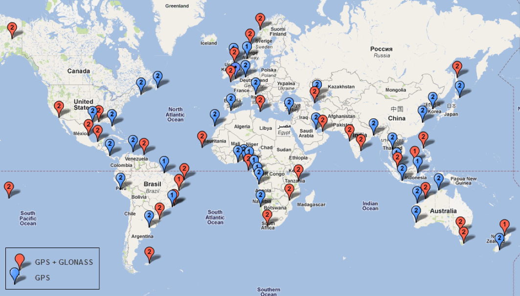
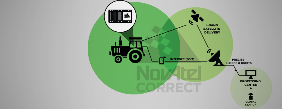
Since its first beginnings in Aberdeen, Veripos has evolved to become a major worldwide business for marine, and now also for “precise land navigation, positioning and guidance solutions.” Veripos is now delivering augmentation services on a global basis, employs more than 130 specialist personnel based in 11 sites around the world, and in 2013 had revenues of more than $45 million. With a global ground network of more than 80 dual-redundant receiver base stations, Veripos now provides not only traditional differential GNSS transmissions, but also precise GPS and GLONASS orbit and clock corrections over seven Inmarsat GEOs and also via the Internet — we now call Precise Point Positioning (PPP).
Veripos ground receiver station network.
Veripos began in March 1989 as a joint venture between Brown & Root Survey and Ormston Technology, a specialist marine electronics company based in Hull, England. Initially, Veripos provided a conventional Differential Global Positioning Service (DGPS) for users in the North Sea based on HF radio transmitters.
Introducing a much broader satellite-based DGPS service in 1994, coverage was extended to cover the Gulf of Mexico followed by further expansion of the network/coverage into Brazil, West Africa, Mediterranean and Caspian Sea. Veripos became a wholly-owned subsidiary of Subsea 7 in the same period. Following a major expansion in late 2004, full global service coverage was achieved in 2005, and ultimately Veripos became the second largest precise satellite positioning services supplier in the world to the marine industry, with leading clients in exploration, seismic, construction, survey, offshore supply vessels (OSV) and offshore drilling. In late October 2012, Veripos diversified further, launching its TerraStar business to address the land and near-shore sector.
Achieving global accuracies of 5-10 centimeters using relatively small amounts of data, users worldwide are mostly able to accommodate the initial convergence time needed to achieve these higher accuracies. Veripos claims that using multiple constellations, convergence time can be down to less than 10 minutes — even lower for hot starts.
The “free” IGS data that competes with Veripos and other subscription correction providers is also pretty good, but it’s not generally used by commercial operations.
IGS Multi-GNSS Experiment Tracking Network.
IGS data is provided by academic and government sources around the world, and the advantage is not only free access, but also open data and multiple open-source software tools and data, all built to published open standards. But the IGS system is not a 24/7 reliable data source, and support can be a problem. It’s not designed for companies who must have service guarantees in order for them to consistently operate profitably in difficult conditions — it’s more experimental, for research and testing for the academic and government outfits that produce the data, along with a whole bunch of engineering teams who take advantage of free data and can cope with system hiccups for their R&D and for comparison purposes.
So Veripos and other commercial providers overcome the weaknesses of IGS by providing a worldwide network that is well maintained — an infrastructure designed for high reliability and availability. Each base station has dual-redundant receiver and communications links. There are three processing centers, two active and one on warm standby, that can each operate the whole system, and each of the processing centers has dual-redundant equipment. There are seven geostationary satellites with a large degree of coverage overlap, and Internet data feeds also provide a backup. More than these system design features, Veripos works directly with its customers to ensure successful integration of their corrections with customer operations and, above all, supports the customer directly during these operations. If the customer is not operational, Veripos recognizes that down time means lost profits for its customers, so its staff work hard to avoid any service interruptions.
It’s not clear what would happen to this currently stable marketplace if and when Galileo begins selling a commercial service on E6, but the existing commercial service providers are pretty sure that competition in their segment from a government provider that is publicly funded is not in their best interests. At the recent Munich Satellite Navigation Summit, Gian-Gherardo Calini from the European GNSS Agency certainly received a clear message from Trimble, NovAtel, Veripos and Fugro (to a lesser extent) that these companies do not believe that Galileo should be entering their market. However, Calini did state several times that the GNSS agency did not want to disrupt this market. How to do that when the Galileo infrastructure, control systems and satellites are wholly government funded remains unclear. Even if the service were wholesaled to a commercial provider, it’s unlikely that the retailer would have to bear the full cost of maintenance and support of the entire Galileo ground and space infrastructure, so their service would in effect be hugely subsidized.
Veripos recognized that focusing on its marine service alone is ignoring the land segment. So the company established a new business called TerraStar to address the land segment, just as Fugro had spun off OminSTAR for the land segment many years ago. TerraStar is still a division of Veripos, and the PPP infrastructure and distribution system it uses is the same. TerraStar is focused entirely on land and close-to-shore operations, so its business development and marketing is aimed at wholesaling its services through OEMs for these segments, while Veripos continues in parallel solely with marine and offshore.
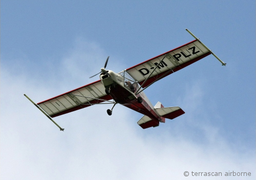
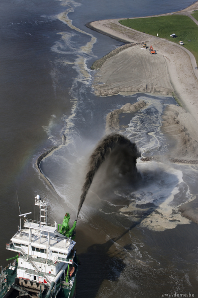
Initial OEMs to sign up were Septentrio and Altus, which is a subsidiary of Septentrio that focuses on survey products and applications. Septentrio had a number of successes with DEME dredging and land reclamation in Belgium and terrascan airborne geophysical survey in South Africa and Germany.
Terrascan airborne geophysical survey.DEME land reclamation.
And here we arrive at the place where these companies all start to come together. In mid-March this year, Hexagon acquired Veripos, along with TerraStar. Hexagon is, of course, the parent that has NovAtel and Leica in its thoroughbred stable of GNSS industry leaders. Could this acquisition have something to do with John Deere/NavCom operating its own StarFire PPP system, or Trimble acquiring OmniSTAR from Fugro and now providing its own range of PPP correction services?
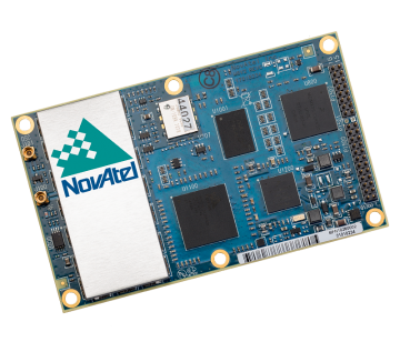
Well, NovAtel rolled out NovAtel Correct and new software at the end of March for its OEM6 high-precision receivers, which includes TerraStar’s precise point positioning (PPP) corrections. And NovAtel now has a closely associated company within the Hexagon stable, so a long-term association between NovAtel and Veripos/TerraStar is just about assured. And, with a big company group like Hexagon and many potential connections between group members with common interests, the prospect for continued investment as revenues increase means Veripos should be even better positioned going forward.
And, of course, adding NovAtel customers, including other potential OEM third parties, to the Veripos/TerraStar user base all helps both companies’ revenue and keeps their parent Hexagon happy too. So actually, it’s all about increasing the bottom line!
Today was the official start of the GEOINT 2013* Symposium. Attendance was estimated at 3,500.
Keynote speakers included James Clapper, director of National Intelligence (DNI), LTG Michael Flynn, director, Defense Intelligence Agency (DIA), and Lettitia Long, director, National Geospatial-Intelligence Agency (NGA).
The full conference guide and videos of many keynote speeches will be available through the GEOINT 2013 website in about two weeks. The full conference guide is available now as a downloadable PDF.
I had an opportunity to attend a separate press briefing by Director Long (watch below).
Included is a large exhibit hall, and today I started touring the booths. In the video below, I talk with Matt Harrison of Skyline as he demonstrates the company’s technology to generate 3D models from oblique imagery.
Also, AirBus demonstrated its global DEM data set.
Today I attended the “GEOINT Forward” which is a pre-conference day consisting of over a dozen loosely related sessions. If there was a common theme it would have to be the increasing evolution of the GEOINT community toward Human Geography, Social Media, Big Data, Small Satellites and Chaos Management.
A most interesting keynote speaker was Dave Snowden (no relation to NSA whistleblower Edward Snowden) founder and chief scientific officer of Cognitive Edge working to analyze complex issues relating to strategy and organizational decision making. He pioneered a science based analysis of organizations drawing on anthropology, neuroscience and complex adaptive systems theory. The key analysis tool they created is SensesMaker, a survey tool that extracts and organizes how respondents make sense of the world through micro-narratives in social settings. Using a patented method the respondent interprets their own story into a series of abstract constructs that feel more like a game than a survey, but allows profound meaning to emerge. This interpretation adds layers of meaning rather than simply interpreting the story and provides quantitative data which can always be linked back to the original material.
There were several sessions related to Chaos Management of disasters both natural and man-made. Dr. Shay Har-Noy of Digital Globe demonstrated TomNod (www.tomnod.com/nod/) which is a crowd sourcing effort of Digital Globe in which the public has access to thousands of images so that millions of eyes could help scour the imagery looking for signs of the missing aircraft. Once potential sites were indentified, experts could then focus their attention on the sites. Here is a short video clip of some examples. (Excuse the quality of the video, the room was dark, sound system poor and the built-in microphone less than ideal)
Last week was spring break (for high school and college) for my kids. We decided to drive to San Francisco and the surrounding area to do a little sightseeing. It’s a beautiful place. This is a view from our 3rd floor room in the hotel, looking over the bay.
Of course, while traveling, I usually manage to work in some GNSS activities.
The first stop was Autodesk, the makers of AutoCAD and other engineering, design and visualization software in downtown San Francisco. AutoCAD occupies 100,000+ square feet at One Market St. in downtown San Francisco and another 20,000+ square feet at Pier 9 right on the Bay. How anyone gets work done with an office on a San Francisco Pier is beyond me. It’s buzzing with people and activity, including a shuttle to the famous Alcatraz Prison, which we enjoyed.
The Autodesk meeting is deserving of an article in itself, but I’ll keep it short with bullet points for the purposes of this article:
AutoCAD 2014 includes a datum/coordinate system library for mapping/surveying users. This is new in AutoCAD.
Infraworks (introduced last year) was built from the ground up with a new workflow for engineers and planners (and surveyors). Most people have never heard of it. It can do things that AutoCAD can’t, such as managing surveying data for large-scale projects. Think BIM (Building Information Modeling).
Model Builder (just introduced), is a tool to build quick and dirty 3D visualizations using data from Autodesk’s cloud service.
Autodesk 123. This is a really cool free app you can use to create 3D models using your own images. The images can come from smartphone pictures or images you already have. It’s a really cool app.
Photogrammetry Chair in the Autodesk Gallery at One Market St. in downtown San Francisco.
AutoCAD 360 (formerly AutoCAD WS). First of all, any Autodesk product with 360 in the name is a cloud app, whether it’s mobile or desktop. I’ll focus on the mobile apps. There are two AutoCAD 360 mobile apps: one for Android and one for iOS. The mobile apps are free tools that allow you to take AutoCAD drawings in the field. There are also Pro versions available on a subscription basis.
Screenshot of AutoCAD 360 on the Apple iPad.
Last week, I had a chance to use AutoCAD 360 in the field with RTK. It was a last-minute exercise that I hadn’t planned on, so my expectations were set so that even if I couldn’t get it to work, at least it would be a solid learning experience.
The goal was to receive 1-2 cm RTK GNSS positions on an Android smartphone running AutoCAD 360 using a public (free) RTK base station. I knew I could access the free RTK base via PBO real-time streaming because I’ve done that before. However, I didn’t know, or have experience in two areas:
Accessing RTK base data via NTRIP on an Android device.
The ability of AutoCAD 360 mobile app to consume GPS data.
For the Android device, we used a Samsung Galaxy Note. It’s a smartphone, but also a tablet with a 5.7-inch color touchscreen.
Samsung Galaxy Note with a 5.7-inch color touchscreen.
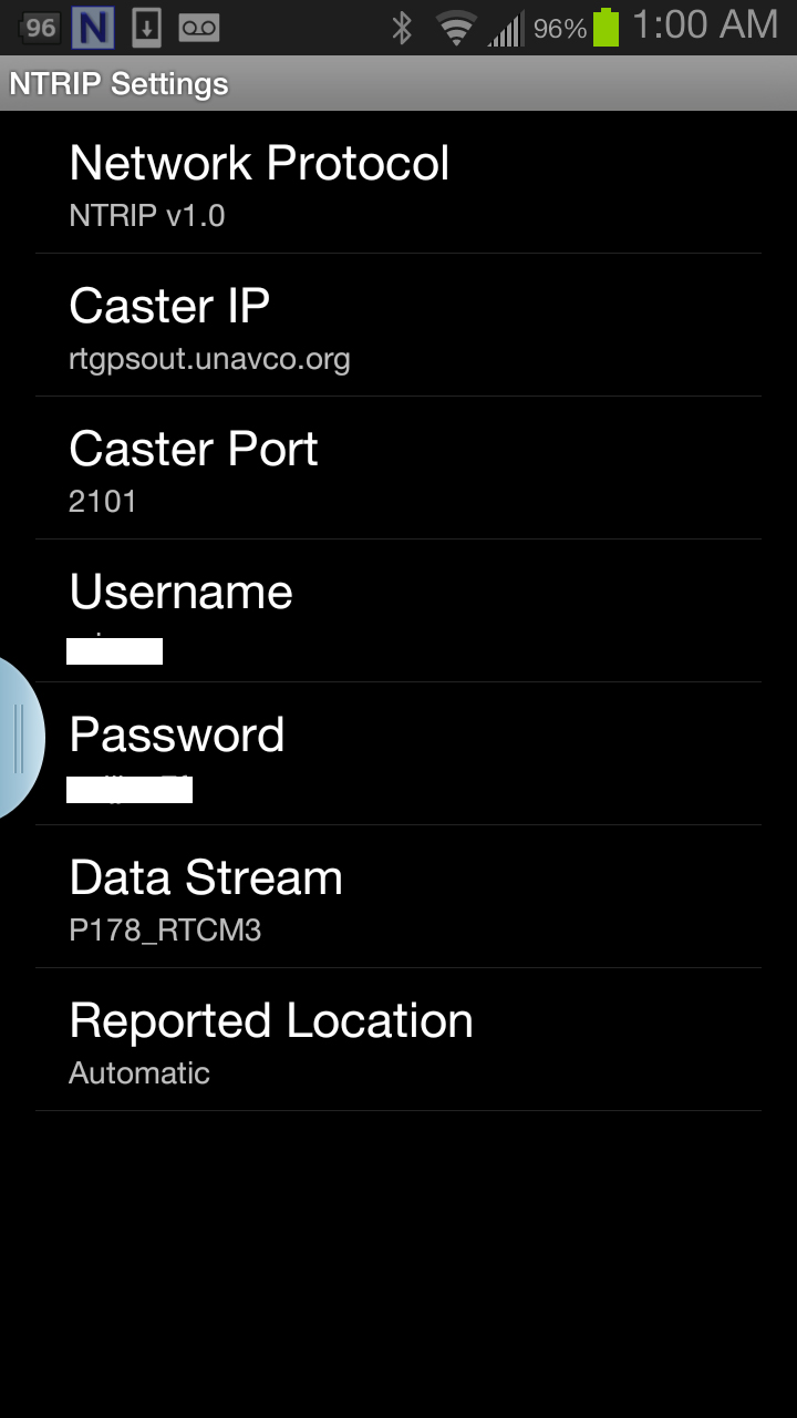
The first challenge was the Android utility software needed to access the RTK base. NTRIP (Networked Transport of RTCM via Internet Protocol). As I’ve written in previous articles, there are lots of free RTK base stations (330+) in California. To access them, all you need is internet connectivity and an NTRIP program to manage the connection to the RTK base. For Windows and Windows Mobile, there are several free NTRIP software programs. For Android, it’s limited (but growing). I found a free Android NTRIP utility on the Google Play store. It’s very easy to install and set up. If you have your RTK base credentials (IP address, port#, login, password), if you have a Bluetooth RTK receiver, you can install the program and be running RTK within a few minutes.
Android NTRIP Utility (Lefebure Design)
Once I entered the RTK login credentials, I was presented with a list of RTK bases. The list of PBO RTK bases are all single-baseline RTK bases (not networked) so I needed to select the closest one to the project site. In this case, it was P178 (see the screen shot above). It was about five miles from the project site. At this point, I can see the RTK base data streaming on the Samsung Note tablet. I didn’t mention before, but I had already Bluetoothed the Samsung to a small RTK GNSS receiver. Once the RTK base data starts streaming, the RTK GNSS receiver goes into FLOAT mode and heading for FIX (1-2cm precision).
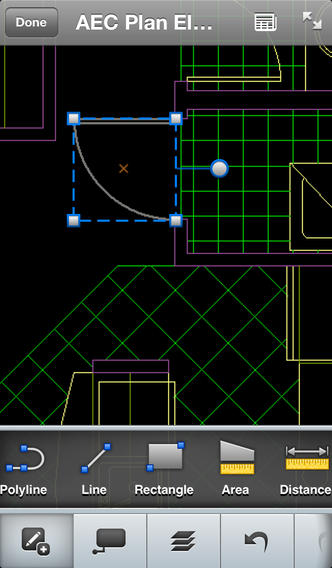
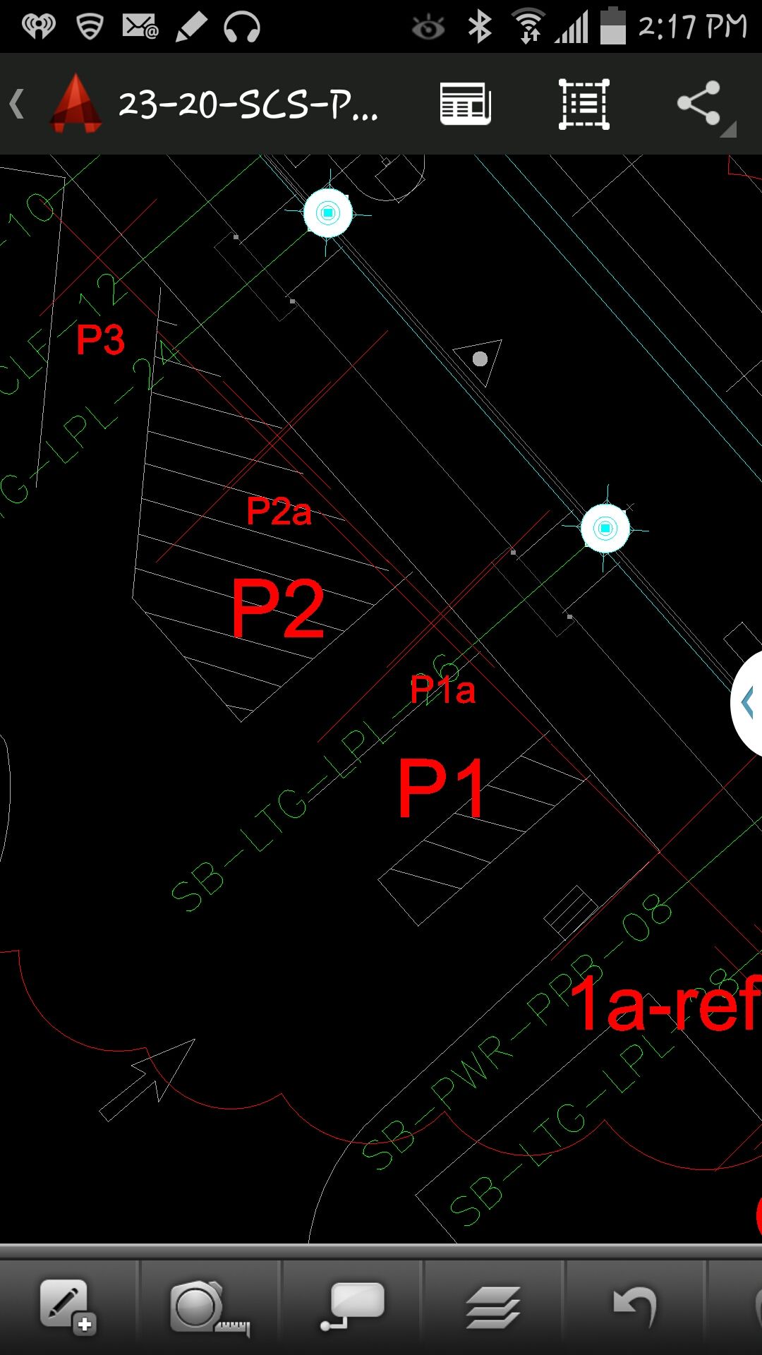
At that point, we (I wasn’t operating AutoCAD 360 on the Samsung) started AutoCAD 360 on the Samsung Note tablet and loaded a drawing that we’d planned to use. Following are a couple of screen shots from our exercise.
AutoCAD 360 running on a Samsung Note Tablet/smartphoneAutoCAD 360 running on a Samsung Note Tablet/smartphone.
It took a minute to figure out how to”turn on” GPS in AutoCAD 360 (we were all newbies), but once we did, our position showed up on the drawing where we expected it. By this time, we were getting an RTK FIX position from the RTK GNSS receiver. We were getting 1-2 cm precision in a native AutoCAD drawing, in real-time, in the field, on an Android smartphone. I was impressed.
We were ready to start our accuracy testing. Our accuracy testing consisted of two parts:
1. To test precision, take RTK shots on two points and measure the distance between the two with a tape measure. We did this several times.
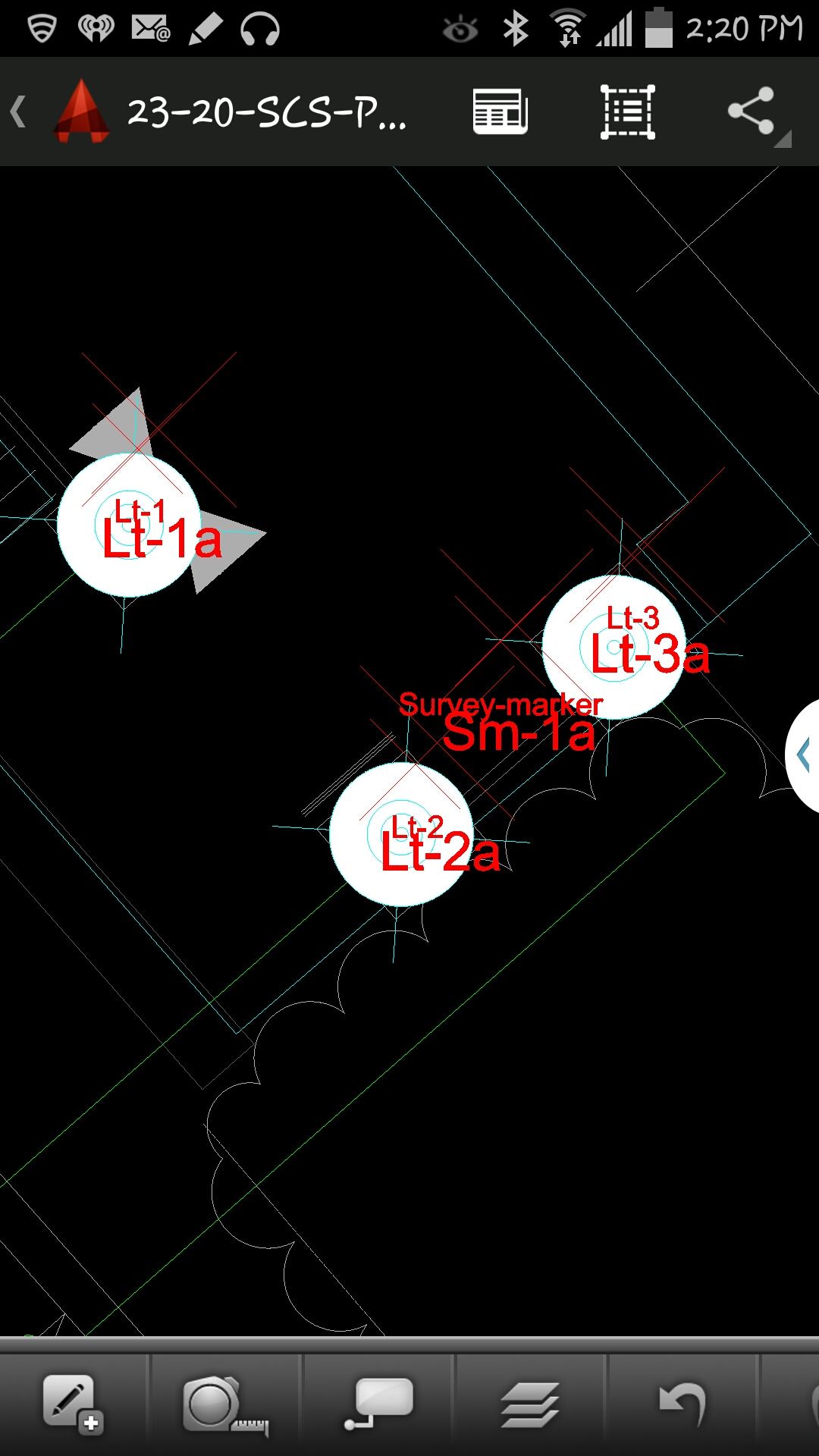
Lt-1 and Lt-2 were on top of a platform with no substantial obstructions.
Lastly, we took a shot underneath a platform with greater than 50% of the skyview obstructed. It didn’t hold RTK in that environment and I didn’t expect it to. The precision was 5 feet (DGPS).
2. The second test was to test accuracy by taking an RTK shot on a survey marker that had published State Plane Coordinates in NAD83/2007 epoch 2007.0
After recording an RTK FIX shot on the marker (albeit I was holding the antenna so I expected a little slop), we compared our result to the survey marker coordinates. Not good…3.0 feet difference.
My first suspicion was that the RTK base was referenced to ITRF, so there would be significant difference between the two coordinate values. No dice. I adjusted the RTK GNSS coordinate to NAD83/2007 (2007.0) assuming it was referenced to ITRF08. The adjusted coordinate was further than the original (6.95 feet). That wasn’t the problem.
My second thought was to double-check what the PBO folks used for a reference position for there RTK bases. They confirmed ITRF08 current epoch. However, after talking to a few people familiar with PBO sites (RTK Network operator and Mark Silver), they suggested to run an OPUS solution on the PBO RTK base and compare it to the reference coordinate being used by the PBO RTK base. Sure enough, there’s a 6.40 feet difference between the 24 hour OPUS ITRF08 coordinate and the ITRF08 reference coordinate being used by the P178 RTK base.
It still doesn’t reconcile the difference we saw between the RTK GNSS coordinate and the survey mark, but I’m still trying to confirm which epoch date the PBO RTK base is using. In California, tectonic plate movement is significant. In that area, the ground is moving 1.7 cm north and 3.4 cm west each year, so the epoch date of the coordinate is significant, especially if the epoch date is 1997.0 or 2002.0. However, that doesn’t prevent you from using RTK Bases like P178 and “localizing” to NAD83/2007 or whichever datum your data is referenced to.
In consulting my notebooks for the spring of 2014, I find many remarkable cases that engaged the attention of my intimate friend Mr. Sherlock Holmes. Among them stand out the tragedy of the ancient British barrow, the disappearance of Pemblestoke the magician, and the curious facts associated with the giant rat of Sumatra, a tale for which the world is still not prepared. Perhaps none of these so well illustrate, however, the advanced technical insights and consultative powers of the great detective as did the intrigue into which we were drawn by the brilliant young American scientist, Geo. P. Hess.
“Watson, we have a new client,” Holmes announced over breakfast, “a friend, actually, upon whom I have depended for many years. He has always proved reliable, helping me navigate the highways and by-ways all across the land.”
“His name?” I inquired.
“The Right Honorable George Parkinson Hess from California, Colorado, Pennsylvania, Florida, and doubtless many other parts of the American nation. I have watched G.P. Hess grow these last 36 years into a prodigiously successful entrepreneur, known the world round for his ubiquity, openhanded generosity to all, and, equally, his devotion to his own country. Now it seems he needs my advice, and I cannot refuse him.“
“I wonder that an American should be able to find his way here this morning,” I replied. “There’s a beastly fog about, and London streets are no friendly environment under the best of conditions.”
“Have no fear, Watson,” Holmes chuckled. “I have never known G. P. Hess to be late for any function. Since a lad he was always on time, right to the second. You can set your watch by him, and as far as I know he has never been lost. He has an uncanny sense of direction and is indeed a fount of knowledge concerning maps and directions. I believe I hear his ring at the bell even now.”
Mrs. Hudson ushered in our American visitor, and Holmes introduced us. “It is always good to see you, G.P. How are you — in good health, I presume?”
“Indeed, Mr. Holmes, things are neither as well they may seem on the surface, nor as well as they could be. I am troubled of late, severely troubled by potential gaps in my future. Not to mention the seismic activity lately in Los Angeles. In the last 18 months, the magnitude of the tremors has grown from 3.1 to 5.1 on the Richter scale. I just can’t understand why they thought to have our major acquisition headquarters in a place that is constantly threatened by tremors, outright quakes, wild fires, floods, landslides, and tsunamis. Not to mention the traffic. It would have been much better to co-locate acquisition with the main headquarters in Colorado. All they have to worry about there are blizzards, high winds, and an occasional wildfire.
“While I could not agree with you more, G.P., I fail to see what I can do, try as I might, about Mother Nature.”
Fire in Florida
“Right you are, Mr. Holmes. I’ll get to the heart of the matter. I am deeply concerned about several of our business ventures: expansion and modernization efforts, if you will. You may have heard about a small but rather serious fire at the U.S. Air Force’s Cape Canaveral radar tracking facility and the subsequent launch delays. That small fire at a single tracking facility has already delayed a National Reconnaissance Office (NRO) launch, and a resupply mission to the International Space Station, currently manned by U.S. and Russian crews who, whether or not they are still speaking to one another, really need the replenishments. Now we aren’t allowed use Russian engine cores for space launch any more. A blessing, actually, as the Russians have put more malfunctioning GLONASS satellites into salt water lately than into the vacuum of space, when they aren’t simply blasting them to kingdom come.
“With all the troubles besetting Cape Canaveral, Elon Musk is burning figure eights in his Tesla, and SpaceX is a very happy company — in the right place at the right time, what? Able to launch its Falcons and Falcon Heavies from Vandenberg as well as Canaveral.
“Imagine, one little fire has caused the cancellation of several space launches, and those still on the manifest are moving to the right daily. We had hoped to put into orbit four new IIF models this year, but that looks next to impossible now. Plus it appears the GPS III payload has hit a snag. It is delayed six to nine months.”
GPS III Delay
“A delay in GPS III had not been looked for, had it?” queried Holmes.
“No sir, it had not. Everything was proceeding smoothly, but now the satellite payload is in question. Subcontractor Exelis has provided every GPS payload since 1978 and all have worked marvelously well, some of them for more than 23 years. But now — there is a problem. Some say it is signal crosstalk, some say it is with the new rubidium clocks. One thing for sure, it is demoralizing. I am given to understand the powers that be in Colorado Springs and Los Angeles are calmly but firmly looking for some competition or even an alternate payload provider.
OCX Delay
“And then there is the GPS ground segment. It has moved one month to the right for every month it has been in existence, it has gone over budget, and now is on its third program manager in three years. Whatever happened to the days when a capable leader conducted a program from beginning to end, knew it intimately from top to bottom, from soup to nuts? What is this world coming to? Where are our leaders?
“And don’t get me started on the effects of ‘seques-castration’!” fumed the young man.
“And the Chinese!” he continued, gathering steam. “Just who do they think they are? Do you know they called their regional system a PNT gold standard? Gold standard! Don’t make me laugh!”
“Now G.P., don’t despair,” soothed Holmes. “There are still excellent leaders out there, you just have to look a bit harder nowadays. In the space arena, Elon Musk, General William Shelton, Wild Bill Cooley, Frank Kendall, and Keoki Jackson are just five of many that come immediately to mind. Of course I would not want to play poker with any of them, but I digress.”
Solutions Appear
“I have been reading and thinking about the alternative payload issue,” the detective continued, “and I have other sources of information as well. Dr. Watson calls them my Baker Street Irregulars, and they are both resourceful and quite knowledgeable. These sources tell me there is another Colorado company, with excellent leadership, that is really on the ball, can move mountains (or huge boulders, anyway), and mark my words, they have top-notch crews, expertise, and even some past performance where an alternative GPS payload is concerned. They might be worth watching.
“As far as OCX goes, frankly I am hearing there are indeed backups and alternatives. My sources have confirmed the existence of a bracket of applicable technologies belonging to a small residual company, run by an Irish clan, believe it or not, with considerable past performance and expertise. Once officially launched to work on the real-time issues, they should be able to help the ground-segment team get back on the fast track.
“As for as the Chinese and their claims, all I can say is no one believes their gold standard rhetoric, although it obviously has a purpose.”
“Mr. Holmes, I hope you are right,” the American replied with an assuaged look. “I knew that if I talked with you I would feel better about these perplexing issues.
“I must resume my journey to Rotterdam, where I will hear a lot more about the Galileo program meeting its launch dates — or not — and the GLONASS outage. As rough a shape as we are in, we’re still far better off than the rest! In the meantime, I’ll pop over to Greenwich to synch up and universally coordinate with those folks before I move on to the Continent.”
G.P. Hess carefully scrutinized his pocket watch. “Now Mr. Holmes, Dr. Watson, I must depart. As you know I have a reputation to maintain: always precisely on time, never lost, and as far as I know, I have never blacked out. Cheerio!”
“What a remarkable fellow, Holmes!” I said after our client had left. “He is certainly full of energy.”
“Yes,” my friend replied, “energetic and very successful. If you had observed him more closely, Watson, you would have noticed his pocket watch. Ah, you did not remark upon it? Standard-issue, atomic-reference version, crafted of solid gold. You might say, and rightly so, that where time is concerned, G.P. Hess is the undisputed holder of the Gold Standard.”
So ends our brief visit with Holmes and the illustrious Watson. Stay tuned for further adventures, and until next time, Happy Navigating! G.P. Hess and I hope to see you all next week in Rotterdam, the Netherlands, at the European Navigation Conference, ENC-GNSS 2014. Drop by and say Hello!
If you can’t drop by and say hello in Rotterdam, the Netherlands, then please join me at the 30th Space Symposium, which is slated for May 19-22, 2014, at The Broadmoor Hotel in Colorado Springs. The Space Symposium is considered by many of us in the Space business to be the premier gathering of space professionals in the world.
In June, I will be attending the 39th NIST Time and Frequency Seminar. It has a great lineup of speakers this year to include: Judah Levine who is the NIST civilian time leader, David Allan who is the original creator of the famous Allan variance, and Neil Ashby, an expert in relativistic timing effects. The seminar takes place in Boulder, Colorado, June 3-6, 2014.
What Is Don Reading?
I had very little time for reading this month, or so I thought — then I had a brief but enlightening correspondence and conversation with local author George E. Nolly, who also lives in Colorado. George sent all four of his wonderful books direct to the Kindle app on my iPad. I had told George I was so swamped I would save his books to read on the airplane on my way to Rotterdam and report on them after the European Navigation Conference.
Then I read just one chapter of the first book and I was hooked. There was nothing for it but to devour all four volumes of the escapades of young Vietnam era USAF pilot, Hamilton “Hamfist” Hancock. Hamfist Out: The Chill Is Gone; Hamfist Over Hanoi: Wolfpack on the Prowl; Hamfist Down! Evasion, Survival and Combat in the Jungle; Hamfist Over The Trail: The Air Combat Adventures of Hamilton “Hamfist” Hancock
It will be like going back in time for many readers of a similar age. George Nolly writes with such an easy-going grace and fluidity that reading of these often stressful and life-threatening times, while sitting in my lounge chair, was, for me anyway, indeed a pleasure.
Certainly I can remember undergoing many of the same flying and ground ordeals, and Nolly tells his tales with such honesty and clarity that it brought back vivid memories. In fact I have never read such accurate descriptions of what it was like to fly the old T-29 with radial engines and all that entails. George actually brought back the unforgettable sound and smell of those two Pratt & Whitney R-2800 radial, air-cooled engines. They are from a long-forgotten era of aviation, but those of us who heard them will never forget them.
T-29A Aircraft, Vietnam era, restored. Courtesy of CONVAIR T29A.
George also makes wonderful plugs for GPS, possibly without knowing it, when he describes using LORAN maps under red lights in a cramped cockpit. This, along with all the time he spent just trying to figure out where he was or where the target was located, just screams for a GPS solution. In truth, in the Vietnam era we airmen spent a great deal of time trying to figure out exactly where we were, where our target was, and where the enemy was located, especially if he was shooting at us. Today all those tasks are made infinitely simpler with the use of GPS and modern electronics. However, this also highlights the amazing feats of airmanship accomplished in the Vietnam era, all while being constantly targeted by the enemy, all the more incredible.
Radial engine.
Just between us veteran airmen, the author relates the tales with such clarity and detail I suspect many of them are autobiographical. George E. Nolly, after graduating from the U.S. Air Force Academy here in Colorado Springs, served as a pilot in the United States Air Force, flying 315 combat missions on two successive tours of duty in Vietnam, winning three Distinguished Flying Crosses and 24 Air Medals, flying O-2A and F-4 aircraft, so he knows whereof he writes.
Even if you are a few generations younger than George Nolly and me, and don’t undergo a nostalgic experience as you read, you will certainly enjoy these fabulous books. Be sure to read them in order, as they are actually one running story that brings to life the trials, tribulations, and joys of Hamilton “Hamfist” Hancock for all of us and vividly recreates the way things were back in the 1960s and ’70s in the United States, the USAF, and what it was like flying in combat in Southeast Asia. I highly recommend these tales. I hope there are more to come.
Upcoming Conferences
If you can’t drop by and say hello in Rotterdam, the Netherlands, then please join me at the 30th National Space Symposium, which is slated for May 19-22, 2014, at The Broadmoor Hotel in Colorado Springs. The National Space Symposium is considered by many of us in the Space business to be the premier gathering of space professionals in the world.
In June I will be attending the 39th NIST Time and Frequency Seminar. It has a great lineup of speakers this year to include: Judah Levine who is the NIST civilian time leader, David Allan who is the original creator of the famous Allan variance, and Neil Ashby, an expert in relativistic timing effects. The seminar takes place in Boulder, Colorado, June 3-6, 2014.
By Tim Reynolds, GPS World’s contributing editor for Europe
This spring, two Brussels conferences focused on new possibilities and modes of transport enabled by satellite navigation, showing the added value delivered by current and future European GNSS solutions.
The European GNSS Agency (GSA) hosted the first gathering in February, discussing its GNSS Applications Action Plan in areas relating to road transport including smart tachographs, long-range buses, transport of dangerous goods, multimodal logistics, and road tolling. The 11th Annual Road User Charging Conference (RUC) in March, an industrial gathering, highlighted recent developments in truck tolling and a possible future breakthrough for lighter vehicles.
Huge Market
The GSA identified the road sector as the largest GNSS market segment (with location-based services) in its October 2013 Market Report. Most GNSS devices were already enabled for European GNSS services, either via EGNOS or Galileo. Developments such as lower costs for connectivity, growing numbers of embedded devices, intelligent transport systems (ITS), and vehicle-to-vehicle (V2V) and vehicle-to-infrastructure (V2I) communications, together with new European Union policies and regulations, drive new requirements for vehicle positioning, and GNSS technologies are poised to fulfill these.
In two specific policy areas, road tolling and eCall emergency response, GNSS shows particular promise for adding value and providing flexible solutions. The GSA manages a large portfolio of research and innovation projects to develop near-market applications in this area.
e-Freight
E-Freight, a vision of a paperless freight transport system where electronic data flow is linked to the physical flow of goods, can lead to future intelligent-cargo concepts to further automate and improve logistics. Positioning services naturally form an integral part of this concept. The increased availability, resilience, integrity, and accuracy offered by European GNSS will support the uptake and efficiency of e-Freight systems through georeferenced cargo-status monitoring, among other services, seamlessly delivered across transport modes and national borders.
Road Tolling
The GSA delivered its perspective on road tolling in advance of the later industrial conference. Location-based charging offers flexibility, easy extension of schemes, low transaction costs, and — most promising from an agency point of view — could have a big impact on traffic management and environmental policy. GNSS is becoming the technology of choice for free-flow road tolling with its three main advantages: coverage, availability, and no direct installation costs.
The final GSA presentation focused on authentication services offered by Galileo to benefit the next-generation digital tachograph, a device fitted to a vehicle that automatically records its speed and distance, together with the driver’s activity selected from a choice of modes. New government proposals for the digital tachograph will mandate the inclusion of GNSS technology.
Clearly, a tachograph requires a robust and trusted GNSS service that is also very low-cost and resilient against spoofing and other interference. An authentification signal provided via the Galileo Open Service could provide a suitable solution free of charge, offering global coverage and easily initiated in existing Galileo-enabled receivers and terminals when the service was introduced. There is growing interest in such a service and its market potential from a range of stakeholders.
Road-User Charging
GNSS should be a key enabling technology for a scalable and cost-effective approach to fair and flexible road charging. But despite its great promise, implementation of such schemes have proven difficult on both sides of the Atlantic.
GNSS-enabled road-use charging systems now operate in Switzerland, Germany, Slovakia, and Hungary for heavy-goods vehicles (HGVs). Plans are in hand for a similar scheme in France covering 15,000 kilometers of national roads. Russia aims to introduce a GLONASS-mandated operation, initially for 50,000 kilometers of federal road and perhaps half a million kilometers of regional roads.
Belgium plans a HGV GNSS-enabled system to start in 2016, initially using GPS and GLONASS signals, eventually covering its full 150,000-kilometer road system. On-board units (OBUs) will be mandatory, and the system will have the capacity to define up to 10,000 toll rates dependent on factors such as location, time of day, direction of travel, road, and vehicle category.
Factor of Seven. The flexibility and scalability of a GNSS-based charging system was demonstrated by the SkyToll organization that operates the road-user charging scheme for HGVs in the Slovak Republic. This system’s network coverage has recently been extended seven-fold from main motorways and major roads to encompass 17,762 kilometers, effectively bring all motorways and class 1, 2, and 3 roads under charge.
To achieve this with a terrestrial system would have required the construction 4,000 gantries, but the huge expansion was built using software in three months. “This is only possible via GNSS,” stated spokesperson Miroslav Bobošik.
The two-way communications possible with GNSS-enabled OBUs also meant that tariff and network models could be updated and amended quickly and easily. Charge collection efficiency exceeds 99 percent and is independent of road type. “There is a clear trend to GNSS-enabled systems due to their flexibility, efficiency and fast implementation,” said Bobošik.
Belgium First? On the first day of the RUC conference, a Flemish regional government spokesperson described plans for the Belgian road-user charging system for HGVs heavier than 3.5 tonnes that could be launched across the whole of the country in 2016.
In parallel to these developments for HGVs, a major pilot project for lighter vehicles, that is, passenger automobiles, has just started in Belgium’s GEN-zone. This area is effectively the capital city, Brussels, and its surrounding provinces of Flemish and Wallonian Brabant. The pilot will test the practicalities of a GNSS-enabled mileage-based charging system and involves 1,000 selected participants in a three-month trial. First results will be available in April, and the final report is due in the summer. This report will form the basis of future national policy on road-user charging and will likely be on the desk of the new Minister for Transport when he or she takes office after the upcoming Belgian elections.
If the political will is there — and post-election the necessary political capital may well be in place — could Belgium become the first nation to implement a GNSS-enabled road-user charging scheme for all vehicles as early as 2016? Watch this space!
Tim Reynolds is director of Inta Communication Ltd. and a long-term Brussels observer writing on many aspects of European government policy and implementation for a range of clients and publications. The material presented here was first prepared in a somewhat different form for the GSA.He is the contributing editor for GPS World’s new quarterly e-newsletter, EAGER: the European GNSS and Earth Observation Report. Subscribe free at env-gpsworld-integration.kinsta.cloud/subscribe.