It used to be that if you were going to build an RF navigation receiver, you had to also build your own simulation system to test it. I remember working with a couple of “home-built” RF simulation systems myself, way back when. We experience a lot of maintenance and support issues. And, of course, if you build something and also build something to test it, its likely that incorrect assumptions will end up in both systems. Today, there are a number of excellent sources for GNSS simulation equipment and support you can buy on the open market.
The spectrum of today’s providers seems to range from highly sophisticated scientific systems used for development by precision receiver manufacturers, through systems with GNSS and aiding solutions, to specialized systems for both general and specific application developers and also for production test. So this month I’d like to try to summarize (in no particular order) what some of the suppliers of GNSS simulation systems are up to, how they may be positioned in the market and, wherever possible, what we might expect to see from them in the future.
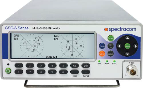
GSG Series 6 GNSS simulator.
Spectracom is a more recent entrant to the GNSS simulation market, though the company has been providing frequency and time synchronization test equipment for about 40 years. Spectracom has integrated GPS into these products for more than ten years, and decided three years ago to use the knowledge it had gained to get into the GNSS simulation business.
The GSG family of simulators is positioned at the “affordable” end of the simulation equipment scale, and is targeted at users and integrators of GNSS, rather than developers of receivers. Spectracom claims to have about 80 percent of the features of the top-end simulations systems, but its more capable (Series 6) systems sell in the $20-30k range. While new to the business, the Spectracom team feels that this allows them to bring the newest technology and innovation to the market.
The Spectracom system is derived from its well-known frequency/time synthesizer equipment — in fact, it has the same look front panel and chassis — and also makes use of the same “easy-to-use” concepts. “It doesn’t take a navigation scientist to operate these simulators,” said John Fischer, chief technology officerat Spectracom. The accompanying Studio View software is reportedly relatively easy to use to generate trajectories and other test scenarios by connecting to Google Maps and uploading them to the simulator.
But with all new firmware and FPGA implementation, 64 channels, and four frequency bands covering both GPS and GLONASS, the GSG family appears to be very well positioned for application developers integrating GNSS. Galileo and Beidou/Compass are in the works and expected this year, and will be supplied as upgrades to existing equipment.
Spectracom anticipates significant growth in its target market for application developers in “anything that moves,” including automotive and airborne, video matching, radar/lidar, and handheld nav devices, including mobile phones. Spectracom has a number of product lines and around 100 people working for them, but the GNSS simulation group is around 12 strong.
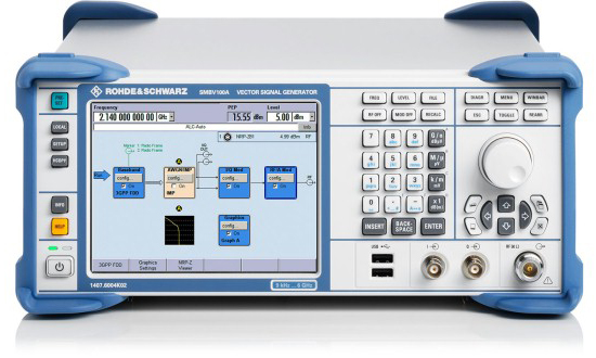
Rohde & Schwarz is another relatively recent GNSS simulation entrant with new products for the market.
SMBV100A vector signal generator.
Its current offering — the SMBV100A Vector Signal Generator – can simulate 24 dynamic GPS, GLONASS and Galileo satellites. The SMBV 100A has wide bandwidth and high output power levels. Real-time test scenarios can be customized by the user — including a neat facility that allows modeling of satellite masking by downtown buildings, along with anticipated multipath for the same urban scenario.
While somewhat new to GNSS simulation, R&S has been around since the 1930s, and its experience with frequency synthesizers and similar equipment is being carried forward into what the company terms its “cost-effective” GNSS simulation offerings. R&S anticipates significant growth in automotive, aerospace, UAV, and cellular assisted-GNSS application markets.
R&S has had success in the aerospace market for UAVs, and has developed the capability to model antenna patterns and UAV body mask as the vehicle rotates and attitude changes towards visible satellites. Along the same lines, R&S has hooked up its system to flight simulators and provided hardware-in-the-loop testing for clients. R&S also has the ability to run simulation scenarios for long periods of time, and for “very long” periods if the receiver is stationary — this feature makes use of large internal memory storage within the SMBV100A; of course, almanac validity limits just how long this is possible. P-code capability is provided as an option, and there is a roadmap for adding SBAS and Beidou capability later.
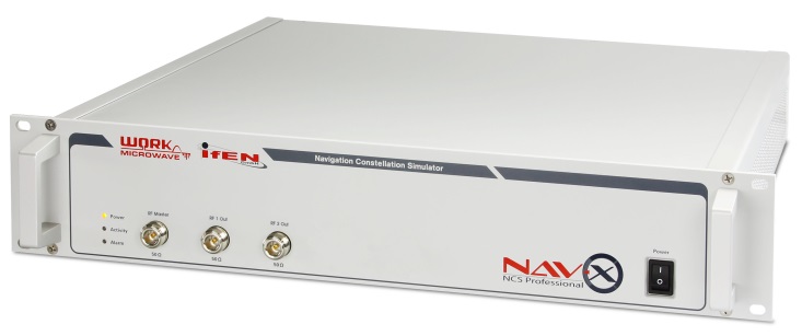
IFEN NavX-NCS Professional
In the meantime, IFEN in Germany is focusing on its NavX-NCS Navigation Constellation Simulator range of multi-GNSS signal simulators.
IFEN emphasizes the flexibility of its design, with a platform scalable from a 12-channel GPS L1 system up to a full multi-GNSS system with 108 channels and 9 frequencies for GPS, GLONASS, Galileo, QZSS and SBAS. With this building-block approach, channels and capabilities can be added as and when additional testing complexity is required.
IFEN claims that the capability to generate all GNSS signals — by combining different modulations with up to nine L-band frequencies — is the only existing solution on the market providing GPS, Galileo, GLONASS, QZSS and SBAS in one chassis at the same time. And, since April 2013, all IFEN NavX-NCS GNSS RF signal simulators are to include BeiDou B1 signal capability in accordance with the official Chinese BeiDou B1 ICD, and are ready for the other B2 and B3 BeiDou signals.
IFEN also founded a subsidiary in the USA in January this year called IFEN, Inc., located in California and operational with Mark Wilson (formerly with Spirent) as VP Sales. In addition, IFEN has formed a partnership with WORK Microwave — a leading European manufacturer of advanced satellite communications and navigation equipment. WORK Microwave is responsible for RF and digital hardware design while IFEN develops the associated software and manages the distribution of the product range.
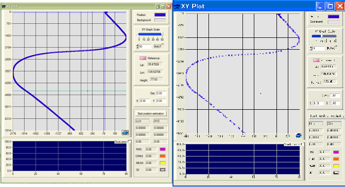
Little-known IP-Solutions in Tokyo, Japan, has been working to develop its ReGen GNSS DIF signal simulator, a software simulator that simulates ionospheric effects, generates digital IF (DIF) signals similar to those recorded by an RF recorder, and comes with an optional capability of simulating integrated inertial navigation.
IP-Solutions’ digital IF baseband signal simulator ReGen has been developed in close cooperation with the Japan Aerospace Exploration Agency (JAXA) to test and validate GNSS signal processing algorithms and methods for use on board aircraft using tight and ultra-tight integration with INS, including specific scintillation models and ionospheric bubble simulation.
Actual recorded flight data (left), ReGen replicated flight data (right).
Various configurations of ReGen can produce multichannel GPS and GLONASS L1 signals and single-channel GPS L1, L2, L5 and GLONASS L1 and L2 signals, as well as simulating noise and interference.
Meanwhile, Spirent, arguably the original market leader in GNSS simulation, has continued along its chosen path of supplying the industry with the greatest capability and most extensive simulation systems.
Spirent has recently released test systems with support for China’s BeiDou Navigation Satellite System in addition to GPS, GLONASS and Galileo.
Spirent started shipping BeiDou-ready systems to its customers in 2012. Now these may be upgraded to full BeiDou capability using the information available in the first full issue of the BeiDou-2 Signal In Space Interface Control Document (ICD).
Also aiming at mobile applications, Spirent’s Hybrid Location Technology Solution (HLTS) integrates Wi-Fi, Assisted Global Navigation Satellite System (A-GNSS), Micro Electro-Mechanical Systems (MEMS) sensor and cellular positioning technologies. HLTS integrates four very different and distinct location technologies and provides repeatable and reliable lab-based characterization of mobile devices supporting hybrid location technologies that will enable “accurate everywhere” location — including indoor user location determination.
Other notable players in the GNSS simulation business include Racelogic, CAST Navigation and Agilent who are each pursuing their chosen niches in this expanding market segment. Racelogic’s LabSat GPS simulator is gaining popularity with a number of leading companies, providing the ability to record and replay real GNSS RF data as well as user-generated scenarios. CAST has an extensive line-up of GPS and GPS/INS simulation systems and support software, and Agilent has added to its impressive electronic testing portfolio with a very capable looking GPS simulation product line.
Several other companies — some based in China and Russia — are also trying to figure out their development and marketing strategies to conquer their chosen GNSS simulation market niche. This is all a very healthy sign that there are many other companies with new embedded GNSS applications that they are bringing to market and who therefore need GNSS simulation/test capability. Overall, this means there is still significant growth underway and far wider applications of GNSS on their way to market. Great news for the GNSS industry!
GNSS is changing. The days of only American GPS satellites providing signals to the civilian population are gone as new constellations are launched. GLONASS was a slow starter, but is now well established, and its signal architecture is now commonly implemented in manufacturers’ chipsets. Galileo is still very much in test phase with global coverage planned for 2019, although position fix using only Galileo satellites has already been demonstrated. The Japanese QZSS system, designed to aid navigation in urban canyons, is partially operational with further launches announced for the near future.
The latest openly documented network to come online is BeiDou-2, or BDS. Formerly known as Compass, the Chinese constellation now provides signals to China and surrounding areas, but plans for global coverage should come to fruition by the end of the decade.
Full control over its own constellation gives a country military, socio-political, and commercial advantages, especially if additional functionality — such as search and rescue services — is introduced alongside the standard navigational broadcast. BDS is unique in its use of a combination of standard-orbit and geo-synchronous satellites, the latter giving it a wider range of signal designed to carry more information.
The populace stands to benefit from a wide variety of localized and global satellite coverage, but only if there are end-user products available that actually make use of the new signals. Any manufacturer wanting a share of the market in China, for instance, will need to get BeiDou-2 integrated into its chipsets quickly, especially if an import levy is placed upon devices that don’t support it (as nearly happened with GLONASS).
How do you go about implementing BDS support in your new GPS product if you’re based in Europe or America? The coverage isn’t global yet; you can’t just go out into the office car park to test, and how are you going to incorporate the signals from the three geostationary satellites without actually being underneath them? Moving to China isn’t very practical, so the solution is a GNSS record-and-replay device.
Manufacturers and other customers will want to seek out simulators from companies that have been highly proactive in ensuring their products provide full support for each constellation, even before they come fully online. The convenience in being able to test new designs, applications, and system integration with reliability and consistency can bring significant savings in development cost and time.
With 14 BDS satellites currently in operation, and the recent release of the Interface Specification, we find more and more companies in the marketplace have been asking for BeiDou functionality. An added benefit for existing users would be flexible hardware capable of taking a simple firmware upgrade in order to record and replay BeiDou as well as GPS and GLONASS.
Icing on the system-testing cake would be a hard drive containing pre-recorded scenarios from China and Europe, with good BDS visibility, so that bench testing can commence immediately. Given that such a device can record raw signals, live recordings can be taken in Asia and then transferred to test facilities around the world.
Mark Sampson is Racelogic’s LabSat product manager. He has more than 15 years of experience in the development of GNSS technology. Working closely with leading businesses such as Bosch, Intel, Samsung, and Telefonica, he provides knowledge and expertise in testing any GNSS device, application, or integration.
GNSS have been with us for more than 30 years, giving rise to a wealth of positioning and navigation technologies for military, civilian, and consumer use. Today, we’re entering a new era of experimentation and innovation in satellite and hybrid positioning. In turn, this drives new test challenges and introduces an ever wider group of engineers to the art and science of GNSS test.
Where Is the Testing Panacea? I am sometimes asked, “What is the best way of testing a GPS receiver?” — as if there existed some laboratory panacea to all GNSS test and characterization woes. Well, there is a saying, “There are horses for courses,” meaning what performs well in one situation may not deliver in another, and nowhere is this more true than in the field of GNSS test. Not only is there a wide range of different test equipment available, but there are no universally applicable test objectives, test methods, or parameter definitions, in exactly the same way as there is not one universally applicable GNSS receiver. Just as the rapid time-to-first-fix of an automotive receiver may be less relevant in a maritime environment, so different test approaches have their place.
A Systematic Approach. If there is one thing, it is this: be systematic in your test design. Consider the purpose of the test, the test conditions, and the measurements you plan to take, and be wary of generic tests that may not achieve your objectives.
Equipment. A wide range of GNSS testing equipment is available, ranging from basic single-constellation RF simulators to highly configurable, multi-GNSS constellation simulators. Single-channel, multi-channel, and record and playback systems all have their place, and to get the best results in the fastest time, it’s essential to choose the kit that’s right for the kind of testing you need to do.
Vulnerability, Fidelity, Integrity, and Time Travel. More and more, receivers need to be tested for their vulnerability to interference, jamming, and spoofing. As GNSS-derived position and time become more ubiquitous, so the motivation for confounding the system grows. This has a double impact on test.
First, performance requirements around vulnerability may be introduced, with tests to match. Second, and perhaps less obvious, is the way in which this concern is reflected in the receiver’s design and potential rejection of the laboratory test signal. Yes, I mean receivers getting more fussy about the signals they lock onto. Anyone who has tested a receiver with an out-of-date recording or simulation scenario will have experienced a receiver refusing to track a satellite showing a time and date prior to its firmware release date. The receiver, discounting time travel, knows there has to be something wrong with a satellite showing a date before it was born. With the risk of spoofing, receivers will only get more picky and likely to reject poorly simulated signals. To avoid such effects, it is important to have very high integrity and fidelity in any simulator system. Getting these details right is not esoteric, but is essential to allow the proper attribution of any problems observed and if test results are to have any meaning.
Conclusion. Be systematic in your approach to test; beware the universal and generic; “good enough,” it rarely is.
Steve Hickling is lead product manager for Spirent’s GNSS simulator business and is based at the factory in Paignton, England. Previously he held a variety of marketing, technical, and management roles in the telecoms and optical components industries. He holds a bachelor of science degree in physics and electronic engineering from Birmingham University, an MBA from Open University Business School, and a post-graduate diploma from the Chartered Institute of Marketing.
By Pierre Nemry and Jean-Marie Sleewaegen, Septentrio Satellite Navigation
Today’s customers ask for high-accuracy positioning everywhere, even in the most demanding environments. The time is long gone that the only requirement for a receiver was to track GPS L1 and L2 signals in open-sky conditions. State-of-the-art receivers operate in increasingly difficult conditions, cope with local radio-frequency interference, survive non-nominal signal transmissions, decode differential corrections from potentially untrusted networks — and more!
Difficult real-life operating conditions are typically not addressed in textbooks or in the specialized literature, and yet they constitute the real challenge faced by receiver manufacturers. Most modern GNSS receivers will perform equally well in nominal conditions, or when subjected to nominally degraded conditions such as the ones that correspond to standard multipath models. However, the true quality of a GNSS receiver reveals itself in the environment in which it is intended to be used.
In view of this, a GNSS manufacturer’s testing revolves around three main pillars:
◾ identifying the conditions and difficulties encountered in the environment of the intended use,
◾ defining the relevant test cases, and
◾ maintaining the test-case database for regression testing.
In developing new receiver functionality, it is important to involve key stakeholders to comprehend the applications in which the feature will be used and the distinctive environment in which the receiver will function. For example, before releasing the precise-point-positioning (PPP) engine for the AsteRx2eL, we conducted a field-test campaign lasting a full month on a ship used for dredging work on the River Thames and in the English Channel. This enabled engineers to capture different types of sea-wave frequency and amplitude, assess multipath and signal artifacts, and characterize PPP correction data-link quality.
Most importantly, we immersed the team in the end-user environment, on a work boat and not simply in a test setup for that purpose. As another example, in testing our integrated INS/GNSS AsteRxi receiver for locating straddle carriers in a container terminal, we spent months collecting data with the terminal operator. This was necessary to understand the specificities of a port environment, where large metal structures (shore cranes, container reach-stackers, docked ships) significantly impair signal reception.
Furthermore, the close collaboration between the GNSS specialist, the system integrator, and the terminal owner was essential to confirm everything worked properly as a system. In both examples, in situ testing provide invaluable insight into the operating conditions the receivers have to deal with, much surpassing the possibilities of a standard test on a simulator or during an occasional field trip.
Once an anomaly or an unusual condition has been identified in the field, the next step is to reproduce it in the lab. This involves a thorough understanding of the root cause of the issue and leveraging the lab environment to reproduce it in the most efficient way. Abnormalities may be purely data-centric or algorithmic, and the best approach to investigate and test them would be software-based. For example, issues with non-compliance to the satellite interface control document or irregularities in the differential correction stream are typically addressed at software level, the input being a log file containing GNSS observables, navigation bits, and differential corrections.
Other issues are preferably reproduced by simulators, for example those linked to receiver motion, or those associated to a specific constellation status or location-dependent problems. Finally, certain complicated conditions do not lend themselves to being treated by simulation. For example, the diffraction pattern that appears at the entrance of a tunnel is hard to represent using standard simulator scenarios. For these circumstances, being able to record and play back the complete RF environment is fundamental.
Over the years, GNSS receiver manufacturers inventoried numerous cases they encountered in the field with customers or during their own testing. For each case, once it has been modeled and can be reproduced in the lab, it is essential to keep it current. As software evolves and the development team changes, the danger exists that over time, the modifications addressing a dysfunctional situation get lost, and the same problem is reintroduced. This is especially the case for conditions that do not occur frequently, or do not happen in a systematic way. Good examples are the GLONASS frequency changes, which arise in an unpredictable way, making it very difficult for the receiver designer to properly anticipate. This stresses the importance of regression testing. It is not enough to model all intricate circumstances for simulation, or to store field-recorded RF samples to replay later. It is essential that the conditions of all previously encountered incidents be recreated and regularly tested in an automated way, to maintain and guarantee product integrity.
The coverage of an automated regression test system must range from the simplest sanity check of the reply-to-user commands to the complete characterization of the positioning performance, tracking noise, acquisition sensitivity, or interference rejection. Every night in our test system, positioning algorithms including all recent changes are fed with thousands of hours of GNSS data, and their output compared to expected results to flag any degradation. Next to the algorithmic tests, hardware-in-the-loop tests are executed on a continuous basis using live signals, constellation simulators, and RF replay systems, with the signals being split and injected in parallel into all our receiver models. Such a fully automated test system ensures that any regression is found in a timely manner, while the developer is concentrated on new designs, and that a recurring problem can be spotted immediately. The test-case database is a valuable asset and an essential piece of a GNSS company’s intellectual property. It evolves continuously as new challenges get detected or come to the attention of a caring customer-support team. Developing and maintaining this database and all the associated automated tests is a cornerstone of GNSS testing.
Wealth, breadth, and depth. That’s what this issue brings you, in signal simulation- and testing-related content. Unfortunately, the wealth on offer has to large extent elbowed out our two news sections, The Business and The System. The former is given short shrift in this issue and the latter even shorter herewith, in pithy precis with website shortcuts. And our apologies.
Let’s all remember, brevity is the soul of wit.
GPS III Flexible Signal Generator. With completion of the Delta Preliminary Design Review for the GPS III satellites, Lockheed Martin and the U.S. Air Force announced that “an innovative new waveform generator permits the addition of new navigation signals after launch to upgrade the constellation without the need to launch new satellites.”
IGS Real-Time Service. The International GNSS Service, a worldwide federation of agencies involved in high-precision GNSS applications, announced the launch of its Real-Time Service (RTS). The RTS is a global-scale GNSS orbit and clock correction service that enables real-time precise point positioning and related applications requiring access to IGS low-latency products. The RTS is offered in beta as a GPS-only service for the development and testing of applications.
QZSS Will Grow to Four. The Japanese government has ordered three navigation satellites from Mitsubishi Electric Corp. to expand the Quasi-Zenith Satellite System, currently orbiting the sole Michibiki. QZSS augments GPS navigation signals for users in the Asia-Pacific region. NEC Corporation has been awarded a contract for the QZSS ground control segment.
Real-Time PPP with Galileo. Fugro Seastar AS achieved this task within a week of all four Galileo satellites being activated. Fugro is now generating Galileo orbit and clock corrections, which can be used in conjunction with the Fugro G2 decimeter-level corrections associated with its GPS/GLONASS PPP service.
BeiDou Ground System Approved. The BeiDou Ground-Based Enhancement System (BGBES), a network of 30 ground stations, an operating system, and a precision positioning system, was approved by a Chinese government evaluation committee. The system is expected to improve BDS positioning accuracy to 2 centimeters horizontal and 5 centimeters vertical via tri-band real-time precision positioning technology, and to 1.5 meters with single-frequency differential navigation technology.
CNAV Test on GPS L2C and L5. The U.S. Air Force Space Command announced that CNAV capabilities on the GPS L2C and L5 signals will be tested in June. The civilian navigation message to be carried by modernized GPS will have similar data to the existing NAV message, but its structure will be different, with increased message bandwidth for greater information density. L2C and L5 users and receiver manufacturers are encouraged to review the test plan, provide comments, and participate in the evaluation process.
GPS at the Smithsonian. Brad Parkinson’s presentation, “GPS for Humanity — The Stealth Utility,” is now available as video on UStream.The talk helped introduce the new Smithsonian National Air and Space Museum exhibit, “Time and Navigation: The Untold Story of Getting from Here to There,” which is now open and free to the public in Washington, D.C.
Years ago when ArcView II first hit the street, I had one of those “eureka” moments at the Esri User Conference Poster Session. I saw a poster of the human circulatory system created with ArcView Network Analyst. I did a double take at first because until then all previous network maps I saw were road or stream networks. I thought, of course, a network is a network regardless of size or composition.
I’m having the same kind of reality adjustment with the technologies demonstrated at the 2013 Consumer Electronics Show, held in Las Vegas in January. It seems like technologies are overlapping in ways we don’t expect — computers, electronics, CAD/CAM, GIS, topology, BIM, medicine, and manufacturing to name a few. Technology paths are no longer direct and simple, but complex and interconnected. With more than 3,000 exhibitors at CES, it’s hard to make sense of it all, so I’ll focus on technologies that may potentially have impact on our GIS community and how we evolve.
Displays
UHD and OLED
Big screen TV’s are always the show grabbers at CES, and there were several examples of OLED (organic light emitting diode) and 4K UHD (Ultra High Definition) TVs from Sony and Samsung that had four times the resolution of current HD TVs — some as big as 110 inches. I don’t believe that UHDs will make a big difference in our ability to present GIS data or imagery, but OLED technology may. Two years ago I wrote about the promise of OLED displays. OLEDs would be big, bright, inexpensive and energy efficient, since the light comes from the OLEDs and not from a light panel behind an LCD screen, like current flat-panel displays. OLEDs are now available, but as you would expect, this new technology is not cheap. However, most experts agree that OLED displays will eventually get to be very cheap. (See my July 2010 OLED article for more details.)
PaperTab is a flexible paper tablet PC.
PaperTab
Related technology from Plastic Logic was PaperTab, a completely flexible “paper tablet PC.” PaperTab combines the feel of paper with the speed and convenience of digital imagery. It looks very much like the Harry Potter Daily Prophet moving pictures newspaper. Work is underway to ultimately work in OLED technology to produce large, cheap roll-up screens that would be very bright and eliminate the need for LCD projectors.
An Oculus virtual reality prototype fascinates a viewer.
Oculus Virtual Reality
Oculus VR is so new that only prototype units are being shipped to software developers. The combination of stereoscopic vision and very effective head-tracking sensors make this device possible. Unlike other VR displays, Oculus has very high resolution plus a 110-degree field of view. 110 degrees provides very broad peripheral vision so users feel totally immersed. The head tracking is so precise and rapid that there is no lag time or motion sickness. Users claim to get adjusted very quickly to the point of forgetting that they are wearing a VR device. This places the Oculus head and shoulders above any other VR system, even six-figure military hardware.
Much work remains to be done by software developers, primarily in the gaming industry. Although gamers will be the biggest customers, I can envision strong use in geospatial applications such as walking through CAD/BIM models or viewing complex GIS data such as environmental or geologic models. I predict that even mundane tasks such as visualizing the location of buried utility lines prior to excavation will become practical.
Control
Tactus provides a soft 3D feel to the touchscreen keyboard.
Tactus
Tactus Technology has taken flexibility to a micro level by producing touch screens that morph small raised buttons under the displayed buttons to provide a soft 3D feel to the touchscreen keyboard. The tactile feel of the buttons is supposed to help speed data entry and usability. We may see this technology in GIS data collection devices soon.
The Minority Report technology by Oblong Industries.
Oblong, Leap Motion and Tobii Gaze
Last year at GeoInt I saw a demonstration of Oblong Industries Seismo, a hand gesture technology to control computer operation. The technology was used in the movie Minority Report, but its usefulness goes well beyond the glitz factor. Interacting with very complex data sets such as USGS earthquake data demonstrates its value. Users claim that once the technology becomes second nature, working with a complex data matrix becomes easier and, most importantly, more understandable.
With the Leap Motion 3D interface, you can control your computer with your fingers at a distance.
Two other related technologies at CES promise to improve on the capability. The first is Leap Motion, which could quickly transform how we use computers. The device is the size of a USB drive and is a 3D interface with sensors that let you control your computer with small precise finger movements in the air. Unlike earlier technology, there is no need to wear special gloves. “We’ve created a technology that could fundamentally change how people interact with computers,” said Michael Zagorsek of Leap Motion. The device will sell for $70 and there are currently over 100,000 pre-orders.
Tobii Gaze is the second company to watch. This company developed a very accurate eye-tracking system that lets you use your eyes as a mouse. Your eye movements and keyboard taps navigate computer interfaces with great speed, precision and accuracy. The Tobii Gaze technology is a single bar that sits above the keyboard. After a quick calibration, users can control Windows 8 with their eyes and a single button push. This could also be a big help to users with paralysis or related disabilities. Will it be possible to combine Tobii Gaze and Leap Motion? It would be interesting.
Robotics
CES showed a number of robot toys, including Lego’s Mindstorm kits along with a flying swarm of robot helos. Don’t discount the serious use of swarm robots. Last year at a special operations tech day, I saw a demonstration of swarm robots that could be dropped in a hostile location to inspect a potential ad hoc runway for potholes. After inspecting the runway, the robots lined up on either side of the runway, turned on bright LEDs, and served as runway lights for the incoming pilot. We may find significant geographic data-collection capabilities from these low cost devices in the near future.
The CubeX 3D printer won a Best of CES Award.
Solid Output Devices
3D printing has been around for many years. Early printers could create solid terrain models by building layer after layer of a powder substrate that was solidified by binders printed in the appropriate spots. The unprinted unsolidified powder was brushed away, revealing the model. The models were not very durable, not very big, and took a long time to create. Very quickly, solid output devices have become a revolutionary new industry with precise laser measurement, using the powder build-up or additive manufacturing by building up and fusing material from a filament. Two big players are 3D Systems with the CubeX 3D printer and MakerBot’s Replicator 2 and forthcoming dual-color Replicator 2X 3D printers. Starting at $2,499, the CubeX boasts a 10.8 x 10.45 x 9.5-inch build area.
3D printers or additive manufacturing have seen an explosion in research and development. Objects can now be produced that are durable and intricate, including complex gears and moving parts using plastics, metal and even organic materials to replicate some human body parts such as ear cartilage. AutoDesk is a big player in the field, and I can see the technology being used for simple 3D terrain models to very complex BIM models and even intricate bridge and overpass construction models. Cornell Professor Hod Lipson, a leader in the field, stated that “3D printing is going to disrupt everything around us” and that “Complexity is free.” By that, he means that with the additive layering of materials, it is just as easy to create a complex object as it is to create a simple object.
This complex titanium part would be impossible to create with traditional machining techniques but was easily created with a 3D printer. (Image courtesy of 3D Systems Corp., Rock Hill, South Carolina.)
An interesting aspect of 3D printing / additive manufacturing is the importance of our GIS mathematics underpinning topology. Topology optimization is the key to additive manufacturing and part of every design process. The results of topology optimization are structures that have outward dimensions identical to normal load-bearing elements such as beams, yet have interior designs that look very different from traditionally manufactured parts. In place of triangular or circular voids, these parts have organic, almost bone-like shapes. This results in parts that are as strong as nature and use materials very efficiently.
The 3,000 exhibitors of CES provided much to ponder. I believe that GIS professionals have core skills and knowledge that position them well to work with many of the new technologies, so career paths may not evolve as many expect. My guess is that someone starting his or her career in GIS today will not end that career making maps.
It isn’t the same old news that the portable or personal navigation device, PND, has lost a lot of ground to mobile applications found on smartphones. The reason it isn’t old news is that the drop in sales is being measured by the millions — from a high of 33 million in 2011 — to a little more than half of that amount. While consumers’ tastes are shifting, often to automobiles equipped with connected features, a smartphone is still the device of choice for quick navigation, location-based services and other features.
While stand-alone portable navigation systems seem to be a fading market driver, connected units seem to be the rage at trade shows and other venues. One example is the recent partnership of Audi of America and T-Mobile USA, who announced a data plan that includes real-time news, weather and fuel prices, Google Earth access and Google Voice Local Search.
The marriage of usually two distinct industries the past three or so years has generated new interest in telematics, which has always been a catch-all term for an automobile’s mobile information features.
While not exactly an eye-opening finding, Berg Insight says sales of PNDs are set to significantly decrease in coming years as consumers choose alternatives. The company says that PND sales will fall to 17 million units, down from the more than 28 million sold last year — and 33 million in 2011.
Berg says PNDs will face stiff competition from lower-cost embedded systems. The company says 150 million people use smartphone navigation apps, compared to 105 million in 2011.
Such companies as Dutch PND manufacturer TomTom said it posted a 13 percent fall, to $262 million, in first-quarter sales. The company is diversifying its product line to counter the loss of revenue from falling PND sales.
To diversify, TomTom rolled out a GPS watch recently to compete with rival Garmin, which has similar products on the market. According to published reports, the company said it is competing with mobile phones for the navigation market.
To echo the Berg findings, TomTom said about 2.1 million navigation units were sold in Europe last year, but in the United States, the drop was even more significant. The company’s PND products fell from 1.5 million units in 2012 to 1.1 million in 2011.
The competition to PNDs is coming from a number of areas. In the recent Audi and T-Mobile deal, users can retrieve information over Wi-Fi for $15 a month (the company says new and existing owners can receive full data services for 30 months for $30 a month). Through the Audi Connect system, users can get connectivity for as many as eight devices.
Audi Connect, which first went on the market in 2011, allows users to gain access to real-time localized weather, news and fuel prices.
Apple Buys Indoor Navigation Company WiFiSLAM
Say what you want about the recent surge in interest of indoor navigation. Some call it an over-hyped fad — or not technically ready for market. The bottom line is that Apple thinks enough of the market to have spent $20 million for Silicon Valley start-up WiFiSLAM in late March.
According to published reports, WiFiSLAM can pinpoint a user’s indoor location to within 8 feet, using Wi-Fi.
Apple has made several inroads to enhance its location portfolio since its Apple Maps debacle in 2012 when users complained about inaccurate directions.
The problems were so acute for Apple Maps that its CEO told potential customers to buy navigation from its rivals, including Waze.
Apple rival Google already has been in the indoor positioning and navigation market, mapping shopping malls, airports and sports venues in several countries.
DeCarta Launches Local Search Engine
DeCarta has launched the L2 Local Search Engine. L2 offers companies the ability to index their own data and make it searchable via a sophisticated single-line search, said Kim Fennell, deCarta president and CEO. Those companies might include local search, vertical search (hotels, restaurants), classifieds, newspapers, Internet yellow pages and others.
“Single-line search is the standard for most web search and for the big mapping portals, but is oddly missing from most local search sites,” Fennell said. “They still use a two-line entry, first specifying what you want and then where you want it. The main reason for that disconnect is that the technology to do good single-line geo-search requires a pretty deep understanding of geospatial data and technology, and is hard to do well. L2 solves that problem. We provide a fully featured local search engine with baseline map and POI data,” he said.
“The local site can clean and index their proprietary data using our tools and then host the search engine in the cloud,” Fennell said. “They get the control of the data and the user interface that the big map portals use.”
Some examples of a deCarta Local Search Engine point of interest entry may be, “coffee near XYZ company,” “restaurants on Main Street,” and “parking near AMC Theater.”
In other LBS news:
Telenav introduced its embedded product for the Scout for Cars product line. The embedded product features in-dash navigation with mobile and cloud services for real-time, personalized information, the company said. Marketed to automakers, the company said installers can connect Scout for Phones service in their cars for real-time services and personalization. The company said the unit comes with flexible branding so OEMs can offer embedded navigation in their vehicles through their own brands.
Audiovox’ $169.99 Car Connection kit tracks vehicles and monitors the driver with a built-in GPS unit and a two-way cellular data connection, without a smartphone, the company said. Once an account is established, and the unit is recognized by the Car Connection service, owners can track their cars’ movements and receive e-mail or text alerts in the event the car is stolen or used without permission. An interesting feature is a free app that allows users to find the car via a smartphone. Car Connection costs $10 a month, or $90 per year, and has a $20 activation fee.
Send your LBS news and announcements to Kevin Dennehy at [email protected].
Report from ENC: Constellation Needs 22 Satellites in Three Years
Launch, deploy, and operate “22 satellites in less than 3 years.” That’s two satellites every three months, leading to a four-at-once launch in 2014. And that’s the challenge that Europe and the European Space Agency (ESA) now face.
This pointed call to action during the opening plenary of the European Navigation Conference (ENC) came from Didier Faivre, director of Galileo Programme and Navigation Related Activities at ESA. It was the only somber note sounded during the keynote speeches, which otherwise paraded the stirring recent accomplishments of the Galileo In-Orbit Validation (IOV) phase. IOV now concludes, and Galileo’s operational phase opens.
The ENC takes place in Vienna, Austria this week (April 23–25), hosted by the Austrian Institute of Navigation. Privately and informally, a handful of knowledgeable conference attendees expressed confidence that OHB System can furnish the completed satellites, at least, according to schedule. OHB System is the prime contractor for construction of 22 Full Operational Capability (FOC) Galileo satellites and is responsible for developing the satellite bus and for integrating the satellites. Surrey Satellite Technology Ltd. (SSTL) is developing and constructing the navigation payload and assisting OHB with final satellite assembly.
“Using only European tools and means, European ground infrastructure deployed on European territory, our conception, machine and design, is totally validated,” stated Faivre, referring to the recent Galileo-only positioning fix by ESA. The March 12, 2013, event marks “the end of the beginning,” and culminates 12 years of intense work at all levels of European industry.
“Europe is at par with GPS” with performance as expected. “I hope that soon our U.S. colleagues will be jealous of our performance,” Faivre stated, implying yet again the persistent Galileo claim that the system will be more accurate than GPS. He returned to this theme with reference to Fugro’s accomplishment of real-time precise point positioning at the centimeter level.
He acknowledged that “It’s a technological competition with the United States, Russia, and China,” even though all may be friendly and collegial.
In that competitive light, “the success of Galileo will be measured by the number of users,” and not by the number of satellites, or the degree of accuracy, or the strength of the signal.
Previously, the ENC audience had heard from Ingolf Schädler that “Europe has closed the gap with the technological superpowers,” in what “may be the most complex invention ever of mankind, the system of navigation that is GNSS.” He also made a proud reference to Austrian-produced signal generators aboard Galileo’s orbiting IOV satellites. Schädler is the deputy director general of innovation for the Austrian federal Ministry for Transport, Innovation and Technology.
“We have reached cruising speed,” announced the third keynote speaker, Carlo des Dorides of the European GNSS Agency (GSA). He was referring explicitly to the re-positioning of the GSA headquarters from Brussels to Prague, but the remarks reverberated to the Galileo program as a whole.
David Blanchard, deputy head of unit, EU Satellite Navigation Programmes for the European Commission, quoted an unnamed U.S. publication: “With the capability to make a position fix from four signal-broadcasting satellites, we can now say that Galileo has truly arrived.”
That statement appeared in the May 2013 GPS World, an issue of the magazine that was distributed in conference bags to all attendees at the ENC.
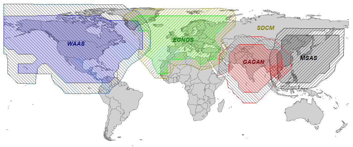
Blanchard then shifted the focus slightly from Galileo, to Galileo together with the European Geostationary Navigation Overlay Service (EGNOS), Europe’s satellite-based augmentation service that also broadcasts GPS corrections. “We have to make sure that all the capabilities afforded by EGNOS are realized.” He also made strong references to the EGNOS Data Access Service (EDAS).
Blanchard cited a current ongoing study that shows that 6 to 7 percent of European gross domestic product (GDP) is dependent upon GNSS.
“A gold mine within arm’s reach of European industry” was how Gard Ueland, head of Galileo Services, characterized the present situation. “Development of European downstream market is crucial; it also has to bring more benefits to European society.” Galileo Services will host a workshop of industry stakeholders in late October, at the OHB System premises in Bremen, Germany. Watch GPS World Events calendar and news for an announcement with specific dates.
Having attained altitude and cruising speed, the Galileo program must now shift to warp speed to hit its goals on time: 18 satellites in orbit by the end of 2014, and a total of 26 by the end of 2015. Early services by the end of 2014, and full services in 2016. Stable, continuous services, as Blanchard emphasized.
Indoor location research and fielded developments currently focus on consumer-level applications, mostly using mobile phone handsets, but this work will hopefully also benefit professional and high-precision uses of GNSS. Indoor location technologies could be of particular interest in machine control for warehousing, industrial assembly, indoor and even underground mapping, underground mining, in forestry where dense canopy virtually cuts out GNSS, construction, and other areas where sky-view is limited or negligible.
Tune in to Indoor Nav Webinar Thursday
Tune in to GPS World’s webinar, “Indoor Positioning and Navigation: Results of the FCC’s CSRIC Bay Area Trials,” on Thursday, April 18. Speakers include Khaled Dessouky (Technocom); Ganesh Pattabiraman (NextNav); Norm Shaw (Polaris Wireless); and Greg Turetzky (CSR). Registration is free.
Professional users will want to keep abreast of developments in the E-911 area, and be aware as achievable accuracies begin to approach what could be possible for precision applications. Right now, that’s maybe a pretty big stretch, but taking a look periodically is a good idea. A recent round of landmark tests by the Federal Communications Commission (FCC) provides just such an occasion for a look-in.
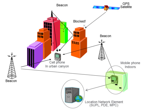
The U.S., E-911 legislation put in place back in 2001 required that both landlines and cellphones should provide the location of callers to within specific accuracy levels. Location information was to be sent transparently to Public Safety Answering Points (PSAPs) which would allow fire/rescue/police personnel to be dispatched to the location of the 911 call. For mobile phones, cellphone manufacturers and network providers forged ahead and implemented a number of location strategies using differing technologies — all require being outdoors where a clear sky-view is available.
GPS and augmented GPS technologies were only part of the cellphone solution. Other implementations included use of the cell-signal itself, along with an extensive database that can contain, amongst other things, signal attributes and network asset locations. Turns out that, today, around 60 percent of mobile phone calls are made within buildings, so the FCC started to investigate how to bring E-911 capability to indoor calls.
In 2011, the FCC commissioned a group called the Communications Security, Reliability and Interoperability Council (CSRIC), and Working Group 3 (WG-3) is the one currently investigating what can be done for indoor E-911 location. Drawn from interested industry participants, the WG-3 Location-Based Services (LBS) sub-group set about finding what technologies exist, how well they work, and how they could be applied to E-911. Now, there are a lot of people trying to crack this problem and many, many ways that it’s been tackled — all of which are at different stages of development and with differing levels of capability. In order to make definitive progress, WG-3 LBS decided that a test-bed was the best way to evaluate and compare what’s currently available.
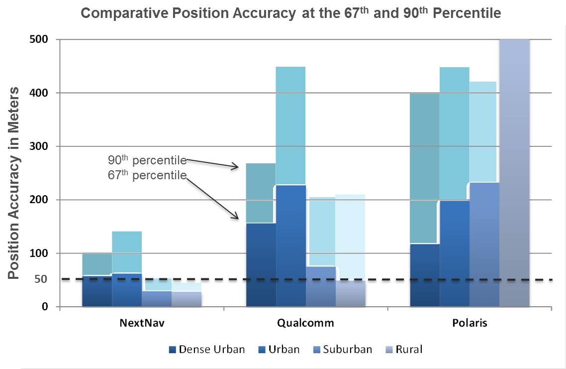
Seven vendors signed up initially, but only three — NextNav, Polaris Wireless, and Qualcomm — completed the rigorous testing, which set out to basically establish horizontal and vertical accuracy, speed of location, and reliability and consistency of results for each system. The trial tested the performance of location systems across urban, suburban and rural areas in the San Francisco Bay Area. More than 13,000 test calls were placed from various tested technologies in 75 different indoor locations selected by participating public safety organizations from around the U.S. Click here for the full report.
In the tests, Polaris Wireless used an RF pattern matching/fingerprinting technique, Qualcomm used a hybrid Assisted-GPS (A-GPS)/Advanced Forward Link Trilateration (AFLT) system, and NextNav used wireless beacon technology. NextNav came out on top, and largely within the magical 50-meter “search ring” requirement, and was the only vendor to provide vertical location capability.
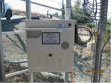
NextNav uses pressure transducers in its beacons and in the handheld units to accurately measure calibrated altitude — within about 2 meters — so it can actually report the floor where the handheld is located; it’s the only system tested that was able to do so. Apparently the use of MEMS pressure sensors in cellphones is forecast to increase to 681 million units in 2016, so this could be the right approach.
NextNav is focusing on the San Francisco market, where the company has fielded a significant number of beacons, but it has also placed beacons in another 40 metropolitan locations across the U.S. NextNav has acquired appropriate spectrum rights to transmit a 900-MHz “GPS-like” signal that’s synchronized to GPS. This enables good penetration into most urban buildings — both high-rise and those with fewer floors.
To support adoption of its solution, NextNav is working with a chipset manufacturer to incorporate processing of its location signal within an upcoming spin of an embedded cellphone chipset. While other solutions have adopted Wi-Fi and cell-signal solutions, NextNav contends that its approach is the most cost effective, as beacon deployment is geographically less dense and can be amortized over so many users.
NextNav Beacon.
Other solutions also apparently rely on the use of databases that store signal characteristics and a number of other parameters – the CSRIC report highlights the complexity this brings to database management and maintenance. NextNav also has a database, but this is basically to store records of location, cable configurations and calibration data. This is only used to ensure consistent performance of their system; it’s not required for network operation or location.
Higher precision applications would also benefit from this type of augmentation in the same way that WAAS users achieve higher accuracies, except this system uses local beacons, and there could be the potential for even higher precision with known fixed beacon locations within urban environments. As commercial UAV applications grow, it’s not impossible that there will be higher precision flight applications within cities, for geo-location surveying, building and outside appliance inspections, signal mapping, traffic mapping, road-work repair monitoring — in fact, many of the monitoring activities we see daily in towns and cities where a view of the sky can be particularly restricted.
The CSRIC participants are not the only ones pursuing the holy grail of indoor location. As mentioned, seven different location vendors/technologies began the process to demonstrate their performance indoors through the common test bed, but only three completed the process. The others remain highly motivated and involved, however, and at work tuning their varied solutions. The WG3 report states, “The following location vendors showed initial interest in having their technologies tested and highlighted through the test bed process, but ended up not participating in the Stage 1 test bed, for a variety of reasons.
LEO Iridium Satellite-based Positioning (BoeingBTL).”
Meanwhile, promising indoor location research goes on at a number of commercial and academic institutions, such as the University of Calgary PLAN group, which has focused on integration of Wi-Fi and GPS. An upcoming paper reports that Wi-Fi, using the 802.11 standards, can be employed in several different ways as a complementary positioning technology for GPS/GNSS navigation, and the two can be used in an integrated framework to provide a continuous and robust positioning service.
Another promising component for indoor location could be the recent release of a software application by Baseband Technologies, which can provide rapid ephemeris for up to 28 days, between ephemeris downloads from GPS directly or over cellphones from the Internet. But indoor location warrants much more extensive treatment than these few random comments — what’s summarized here are only some recent developments in E-911.
There will likely be another round of E-911 test-bed activities if funding and management issues are resolved. See CSRIC WG-3 LBS Subgroup member Greg Turetzky’s “Expert Advice” column from GPS World for perspective and a forward look. We can anticipate even wider participation by differing technologies and even greater levels of performance in future. Longer term progression towards higher precision professional applications seems to be inevitable.
Neither rain, sleet, snow, hail, wind, nor dark of night will deter…
Loosely Translated, Herodotus, Histories (8.98)
…attendees at the 29th National Space Symposium from their appointed rounds.
Seriously, folks, with apologies to postal workers everywhere, here in the Rocky Mountains it was 72 degrees on the eighth of April, the first day of the largest space symposium in the world. This morning, the ninth, the startled thermometer hovered around eleven degrees with snow, high winds and attendees searching for any outer wear they could find. And except for NASA (National Aeronautics and Space Administration) personnel, everyone braved the weather and soldiered on.
NASA, of course, one of the few government agencies with space in its name, decided they did not need to attend the National Space Symposium this year. But that is NASA’s loss and a story for another time, because more than 9,000 other dedicated space professionals did attend, and more than 170 companies provided major exhibits that filled to capacity the largest pillar-less exhibition hall west of the Mississippi. Just writing this makes my feet hurt. And the best part is this all takes place at the five-star Broadmoor Resort in the foothills of the Rocky Mountains, hence Mother Nature’s raucous spring weather shenanigans.
This is truly a watershed event for the global space community, and it improves every year. I have had the honor of attending 25 of the 29 National Space Symposiums, and as usual there are always a few major topics of interest that everyone wants to discuss. This year I can literally not walk ten feet without someone stopping me to discuss:
The error-plagued GAO (Government Accountability Office) OCX (Next Generation GPS Operational Control System) report and subsequent regrettable sensationalized news reports
The actual status of the OCX program
Lockheed Martin’s GPS III program
NavSat – Nee Parkinson’s NibbleSat – real or imagined
Software-defined GPS receivers and GPS user equipment in general
When it comes to opinions, informed or otherwise, concerning each of these topics, the resulting litany reminds me of the old saw about asking three psychologists to comment on a patient’s diagnosis, and you will invariably wind up with four opinions. But have no fear: I spoke directly with the prime companies developing each of these programs, and the following is straight from the horse’s mouth, or some other part of their anatomy as the case may be. You be the judge.
GAO and OCX
The Government Accountability Office, which historically is anything but, released a report on March 28titled “Defense Acquisitions: Assessments of Selected Weapon Programs,” in which it seems to claim that the original $886 million GPS OCX program awarded to Raytheon Information Systems in Aurora, Colorado, in February 2010, has grown by 43 percent and ballooned to $3.695 billion. In fact, the report does not actually say that exactly, but you have to dig deep to determine that. Most readers won’t take the time to do that and will assume that the OCX program is grossly over budget. It is not. In fact, to reach that extraordinary number, OCX cost overruns would need to have grown by 43 percent for each year since it was awarded, and that is ludicrous. According to Raytheon VP and OCX Program Manager Ray Kolibaba, the $3.695 billion number probably comes from including “…programmatic costs beyond OCX development costs and pessimistic projections from the government” that in my experience no acquisition agency, nor Congress for that matter, would ever include when determining true program cost adherence parameters. Such ancillary costs would certainly never be included in a Nunn-McCurdy-Sarbanes-Oxley-Graham-Rudman-Harry Potter fiscal responsibility evaluation.
Speaking from personal experience, in 1990 I was appointed the very first Legislative Liaison Director for Headquarters Air Force Space Command. I had a small office and staff and spent most of my time on Capitol Hill meeting with congressmen and senators, where I advocated the latest space programs, and/or sat in on congressional hearings and then advised senior U.S. Air Force space officials on what budget and policy decisions they could expect from Congress. And I can tell you now, using the methods the GAO concocted to compile this report, I could cause any space program to come under close and unwarranted scrutiny. However, using time-tested congressional oversight rules of engagement (ROE), OCX has not come close to triggering any of the automated congressional watchdog cost overrun tripwires. The truth of the matter is OCX has grown in scope and schedule due in part to government change requests, mainly in the cyber and information assurance areas, along with affordability mandates due to schedule slips and sequestration. According to Stephen Moran, Raytheon mission solutions director, the true cost of OCX today is approximately $967 million, which means the total program cost to date has grown by approximately 10 percent, a far cry from the fictitious annualized 43 percent increase claimed by the GAO. While the GAO goes to great lengths to justify its inflated numbers, it is comparing or rather sensationalizing apples and oranges.
Some may say, so what? Who outside of Washington D.C. reads or believes GAO reports? Unfortunately, Congress, the congressional staff and congressional budgeters read these reports, since the GAO is officially the investigative arm of Congress. In fact the GAO is an independent, nonpartisan agency that works for Congress. Often called the “congressional watchdog,” GAO investigates how the federal government spends taxpayer dollars. And many times they do a great job. But in this case they are wide of the mark. It would be a shame if Congress cancelled OCX because of a flawed or, at a minimum, a poorly explained report.
Ray Kolibaba and Stephen Moran assured me during our talks at the 29th NSS that OCX was alive and well and on track to meet a re-baselined time and costs schedule. OCX Block One RTO should occur as planned in the first quarter of 2017 and will include the ability to launch and control GPS IIF and GPS III satellites and payloads, but not GPS IIA satellites and payloads. That mission, along with the responsibility for maintaining residual satellites, still falls to the LADO (Launch Anomaly and Disposal Operations) contractor Braxton Technologies, which is an OCX subcontractor to Raytheon.
The bottom line is the OCX schedule has slipped and the budget has grown, but within historically acceptable parameters; certainly, it is not even close to triggering congressional oversight. However, having said that, in this budget sequestration environment, the overall GPS budget has taken some significant hits so that even the slightest cost overrun is of concern. Still, let’s hope that Congress makes funding decisions using actual historically acceptable numbers and not overblown rhetoric.
LMCO and GPS III
Keoki Jackson
Let me say right up front that I really like Keoki Jackson and what he has accomplished on the GPS III program at Lockheed Martin. Keoki is the vice president of Navigation Systems, and as such heads the GPS III program. Keoki has an honest and open demeanor and just oozes integrity. He runs a very open program and, indeed, has extended an open invitation to me, wearing multiple hats, to visit the LMCO GPS III facility in Waterton, Colorado, to discuss GPS III anytime. Believe me, I have and will continue to take him up on his offer. To someone in my line of work, that confidence speaks volumes. Keoki obviously has supreme faith in his people, and is assured the GPS III program is on the path to success. I spoke with Keoki on Monday, April 8, as I toured the GPS III facility with him. He was like a father with pictures of his children. Happy, smiling, engaging — he could not wait to show off their latest accomplishments.
My bottom line is this is a rare attitude among senior execs and PMs on major space programs. And that may be because so many of them are under congressional scrutiny. Not the case for GPS III, however. The back-to-basics GPS III program is on schedule and budget, and is set to deliver GPS III SV-01in May 2014, exactly six years after program award. The USAF has said it may not launch the first GPS III until April 2015, but that is a separate ground support and commanding issue. It has nothing to do with the schedule and availability of the GPS III satellites.
Historically, LMCO-built satellites are some of the best in the world. According to LMCO statistics, and verified by yours truly, LMCO GPS satellite vehicles have accumulated more than 175 operational years on orbit with a reliability record better than 99.9 percent. Keoki also proudly pointed out that the Lockheed Martin heritage dates back to the production of the Oscar and Nova Transit satellites — programs that paved the way for the current GPS gold standard on orbit today.
Now, don’t let the back-to-basics approach fool you. That just means sound, solid, proven engineering and management practices are employed, but the technology is anything but basic. The kingpin of the LMCO GPS III approach is an artifact known as the GNST, or pathfinder spacecraft. The GPS III Non Flight Satellite Testbed (GNST) gives everyone confidence that Lockheed is on the right track. The pathfinder goes through all the rigorous steps a flight article goes through, only it completes them first and allows LMCO personnel to find all those schedule-busting, expensive glitches that show up in any program. As Keoki said, “Our endeavor is to find any anomalies now before the satellites and payloads are on orbit.” The GNST, along with cutting-edge 3-D motion studies with avatars (an amazing story and teaser for another time), will hopefully allow a smooth transition for SV-01 through SV-09 when the program plans to initiate programmatic and hardware changes to allow for the first-ever GPS dual launch.
This is a far different approach from the Boeing GPS IIF spacecraft and payloads, which experienced major anomalies on orbit for the first two SVs. Changes were made to subsequent ground space vehicles before launch, but the first two SVs on orbit are stuck with those anomalies. The LMCO approach hopes to eliminate or at least minimize that risk. If the full LMCO GPS III program comes to fruition, there could eventually be as many as 32 GPS III satellites in various configurations on orbit. Which means Keoki will probably be referring to GPS IIIs not as children but grandchildren, and he will need a much bigger scrapbook. Bottom line, GPS III is alive and well, on schedule and budget.
NavSat or NibbleSat
For those of you who have not heard about the NavSat or NibbleSat, it is a small GPS satellite endeavor by AFSPC, SMC, and AFRL to determine the feasibility of building a GPS-only small satellite, one without NDS, SAR, or any other auxiliary payloads. However, this is not solely a Weight Watchers program — it is about far more than a slimmed-down GPS. It addresses technological aspects of the GPS program as well as SWAP (size, weight, and power) issues that have plagued the GPS program since its inception.
Since 1978 when the very first GPS satellite was launched, the program has grown in complexity and size with ancillary payloads, more signals, more power, and more flexibility, which all add up to a heavier, more complex satellite — and in space, where weight and complexity equal greater costs. GPS III has finally reached the point that it will cost nearly $450 million to place a single GPS SV and payload in orbit.
As I said earlier, the GPS III payload may last 30 years, which equates to a sizeable return on your investment (ROE) for space assets, but in this constrained sequestration budget environment Congress is not looking down the road 30 years; it is barely able to consider the FYDP or the next five years’ development plan budget. So $450 million per GPS III on orbit is a big number. Even with dual launch, according to Lockheed’s Keoki Jackson (see above, “LMCO and GPS III”), from SV-09 forward the savings will only amount to about $70M per launch because it will require a larger launch vehicle. Certainly, $70 million is not a number to disregard, especially if you could build and launch a small GPS-only SV for that same amount. I know it sounds nearly impossible, but that is what the NavSat program hopes to achieve. To date, no less than 20 companies, U.S. and European, have expressed an interest in making NavSat happen. Most companies I spoke with are convinced it is not a technological issue, but a commitment and funding issue on behalf of the U.S. government. So what else is new? In my book, NavSat is a real possibility, and the recent plethora of BAAs (Broad Area Announcements) from SMC (Space and Missile Systems Center), AFRL (Air Force Research Laboratory), and SPAWAR (Space and Naval Warfare Systems Command) attest to that fact. Stay tuned for more.
GPS Payloads, Receivers: Software-Defined and Otherwise
It is a fact of life where GPS is concerned that when you talk about GPS technology, you are talking about ITT Exelis. There is not a single U.S. GPS payload on orbit today that was not built in whole or in part by ITT Exelis. There are few companies in the world today that can claim such a prestigious record for space assets that are arguable the best in the world. The ITT Exelis record of providing proven GPS payloads for 35 years is unequaled in the space arena, and the company continues to innovate and grow. So, it should come as no surprise that Exelis provided LMCO with the GPS payload for the GNST pathfinder mentioned earlier. The bottom line is, when it comes to GPS payloads, nobody does it better than ITT Exelis.
Therefore, I took the opportunity to sit down with Mark Pisani, a vice president and general manager in the geospatial systems business at ITT Exelis, to discuss the recent $2.15 million contract award from AFRL to research navigation payloads to support the current GPS program and the NavSat program specifically. Mark stated that the technologies being investigated could easily translate to the entire GPS program.
Mr. Pisani stated that over the next 18 months, the company will conduct research into potential methods to reduce payload size, weight, and power, and improve GPS signal strength and reception for disadvantaged users, especially warfighters, in either urban canyons or mountainous terrain. ITT Exelis is also working on new methods of tamper-proofing for its GPS reference and monitor receivers, which will deployed around the globe to ensure GPS accuracy for all global users. So it appears that where GPS is concerned, you name it and ITT Exelis is working some aspect of the program.
NSS Wrap-up
Space Foundation Leadership Team.
NSS 29 is still in full swing as I write this. Indeed, my old friend and colleague in uniform, General William (Willie) Shelton, just gave his state-of-the-military-space-community address, and he did it in his usual exemplary manner. Few generals can match his grace and style. But to paraphrase Robert Frost, “…deadlines, time and tides wait for no man,” so I will wrap up with a few personal observations.
As many of you have heard me say, year after year, the National Space Symposium is like no other space event in the world. It gets bigger and better every year, and this year events extended all the way to LMCO in Denver and to Broadmoor properties that have never been used for this event previously. The NSS agenda and speakers are top notch and international in nature. Just a sampling are George Nield, associate administrator for commercial space transportation at the Federal Aviation Administration (FAA), Jean-Jacques Dordain, director general of the European Space Agency (ESA), and Yasushi Horikawa, chairman of the United Nations Committee on the Peaceful Uses of Outer Space. Officials from commercial space leaders such as LMCO, SpaceX, Boeing, XCOR Aerospace, Sierra Nevada Space Systems, and others will also speak, while actress Sigourney Weaver, star of the Alien films among others, is the featured speaker at the Space Technology Hall of Fame gala tomorrow night. So there is literally something for everyone.
Sigourney Weaver
I have known Elliot Holokauahi (yes, it is a mouthful) Pulham (CEO), Chief Chuck Zimkas (USAF, Ret) who serves as president of the Space Foundation, and Holly Roberts, the CFO, for many, many years, and they are always striving to make the National Space Symposium better every year; in my book, they have succeeded beyond anyone’s wildest dreams. Their zeal is combined with the dedicated support of Steve Bartolin, CEO and president of the Broadmoor. I first met Steve more than 25 years ago when he ran the famed Greenbriar Resort in White Sulphir Springs, West Virginia, the playground of congressmen and senators. Steve has always had a penchant for living in places that ended in Springs, as well as for perfect service, while going to great lengths to make sure his employees are happy and enjoy their work. It shows at the Broadmoor, which is a Triple AAA Five Diamond Resort, and has been for more than 20 years. Together, Steve’s commitment to perfection and the vision of the Space Foundation make the National Space Symposium not only the world’s largest but by far the best space symposium in the world today.
Braxton Technologies Sets the Example
Personally, I enjoy the exhibit hall and tend to spend most of my time there. The event along with the Cyber presentations lasts for four full days, but you cannot see and do everything in that time, which leads me a personal observation. Many of the vendors and exhibitors in the past several years have begun to offer refreshments in their booth space, to help draw in the huge crowds always roaming the exhibition floor. Some offer ice cream, coffee, even beer and pretzels, but personally I like what Braxton Technologies has developed. Remember, this is a Space Symposium, so Braxton decided to mount small-scale full working models of various satellites above their booth space and allow attendees to actually send wireless commands to control the satellites. You can sit at one of their control stations, see a real spacecraft commanding (TT&C) screen, send commands to the scale-model satellites, and watch the satellites react in real time.
Now, Fred (I call him the model builder and engineer extraordinaire) is the one who built the majority of the models, and they are an excellent example of fine craftsmanship. Indeed, the first night there were some issues with one of the older models, and Fred stayed in the booth working the problem from closing time on Monday evening until 0700 on Tuesday morning. And his hard work paid off, because there is always a crowd around the Braxton booth waiting to control or just watch the satellites respond. The Braxton folks are very good at and very proud of what they do, and it shows. They automated GPS scheduling, on their own nickel last year, and this year offer a glimpse at the future of GPS mission planning. Plus, they have an application for unimproved aircraft landing sites around the world that is simply amazing.
But, in the end it is watching the children, the future space operators and astronauts, who gather in huge crowds around the Braxton booth, waiting with thinly veiled anticipation to send a command to a satellite. It has been a long time since I was a child, but you should have seen the smile on my face when Fred allowed me to send a command and I could see the satellite model respond. Both Frank Backes, Braxton CEO, and Kenny O’Neil, Braxton president, and most of the Braxton employees are former space operators, and they have not forgotten the thrill of actually commanding satellites. Now they have made that thrill available for our future space operators. I think they hit it out of the park.
There’s still time. Drop by the Braxton booth, speak with Fred, and send a command to a satellite. Oh, and you are allowed to smile!
Until next time, happy navigating, and go fly a satellite!
The long awaited results from the independent field trial of indoor wireless location technologies are here. TheFCC-chartered Communications Security, Reliability and Interoperability Council (CSRIC) tested NextNav, Qualcomm and Polaris. NextNav bested the others.
Speakers from NextNav and Polaris, as well as test adminstrator Technocom, will take part in a GPS World webinar on April 18. Registration is free.
Also, there is a guessing game in town and stakes are high. Who will President Obama nominate to replace FCC Chief Julius Genachowski? Tom Wheeler, popular in the telecom community, has been a front runner, but the tide may be turning against him with some charging that he is too snug with our industry.
Developers will be even more enticed to utilize indoor location now that Apple has signaled its market intents with the purchase of indoor-GPS company WifiSLAM. Safety and security mandates around the world are spurring a wave of telematics offerings by automotive OEMs. For more, read on.
Who Will Be the New FCC Chief? A coalition of public interest groups sent a letter to Obama warning that Wheeler is too close to the industry that he would be regulating. “You can’t have an objective chairman of the FCC that’s got 20 years of his life invested in being the head lobbyist for industry,” Sascha Meinrath of the New America Foundation said in an interview. In his past life, Wheeler was an industry lobbyist and also served as head of both CTIA and the National Cable and Telecommunications Association.
Adding to Wheeler’s woes, 37 Democratic senators have signed a letter supporting FCC Commissioner Jessica Rosenworcel. Since she already sits on the commission, Rosenworcel would not need Senate confirmation to ascend to the chairmanship. That could be appealing to Obama, who has faced GOP opposition to many of his second-term nominees.
However, it could also put Obama in a sticky spot, as he would have to jump over the FCC senior Democrat, Commissioner Mignon Clyburn, the daughter of Rep. James Clyburn, a member of the House Democratic leadership who has strong African-American support. Obama has been criticized for low minority leadership appointments in his second term.
Genachowski’s term was a disappointment to people on many sides of the fence, but not the all-out disaster of his predecessor, Kevin Martin. Genachowski will be remember for the introduction of the National Broadband Plan, as well as plans for a complete overhaul of the Universal Service Fund. During his time as chairman, Genachowski took the lead on killing AT&T’s proposed $39 billion acquisition of T-Mobile. The next FCC chair will need to navigate hefty issues including media ownership, Internet rules, universal and affordable broadband, and locking of phones.
How Good Is It Indoors? The FCC chartered CSRIC to test the indoor performance of location systems across urban, suburban and rural areas in the San Francisco Bay Area. TechnoCom, an independent agent, conducted the trial with more than 13,000 test calls placed from different technologies in 75 unique indoor locations. Three vendors submitted technologies for evaluation: Qualcomm, NextNav and Polaris. They were scored for horizontal and vertical accuracy, speed of location, and reliability and consistency of results. NextNav stood out for its performance on height and horizontal accuracy. The full report is available from the FCC.
To hear from the experts involved, tune in to GPS World’s webinar, “Indoor Positioning & Navigation: Results of the FCC’s CSRIC Bay Area Trials,” on Thursday, April 18. Speakers include Khaled Dessouky (Technocom); Ganesh Pattabiraman (NextNav); Norm Shaw (Polaris Wireless); and Greg Turetzky (CSR). Registration is free.
Apple Goes Inside. Apple has acquired indoor-GPS company WifiSLAM, a sign that the indoor mobile location market will be heating up. Apple’s involvement is a significant move that will ignite the developer community to rush to create more innovative apps and solutions based on indoor location. WiFiSlam is a two-year-old start-up that detects a phone user’s indoor location by analyzing the strengths and IDs of Wi-Fi signals in its vicinity. WiFiSlam has been offering the technology to developers for indoor mapping and new types of retail and social networking apps. Retail has been the first adopter of indoor technology.
Interactive Voice Ads Leverage Location. Nuance Communications unveiled Voice Ads, a new mobile ad format that enables consumers to interact directly with ad campaigns by speaking (or perhaps, yelling) into their smartphones. Voice Ads expands on voice and natural language technologies and leverages capabilities like location to deliver ads that prompt the user to ask questions. In a YouTube video, Mike McSherry of Nuance demonstrates a virtual Magic 8-Ball campaign that answers users’ verbal queries to promote a fictional deodorant brand. “Mobile has a monetization challenge,” McSherry told AllThingsD. “By introducing voice you can transcend the small screen size.”
Telematics Boom. The telematics market is about to ride a wave of growth. Vehicle OEMS are rolling out safety telematics in advance of safety and security mandates throughout the world including Europe (eCall, 2015), Russia (ERA GLONASS, 2013) and Brazil (Contran, 2013). ABI predicts that the OEM and aftermarket safety/security telematics vendors will see the number of users rise from 72 million at year-end to more than 300 million in 2018.
GPS Ankle Monitors Not Working. In 2012 the state of California started conducting tests on the GPS ankle devices that monitor more than 4,000 high-risk sex offenders and gang members. Officials discovered that the batteries died early and reported locations were off by as much as three miles. Tampering alerts failed and offenders could cover the devices with foil or use GPS jammers to go undetected. Many of California’s ankle monitors were replaced with devices from a different vendor, but test results of the new system were not made public.
I probably reminisce a bit too much at times, but I can’t help but think back to the ’90s, when obtaining three-meter accuracy via post-processing took a bit of planning. You either had to operate your own GPS base station, or you had to find a publicly available one before you went to the field to make sure you had a source of base station data. Remember, back then publicly available CORS weren’t very common.
Then, towards the late ’90s, there were enough publicly available GPS CORS in the U.S. that you could collect data in the field without knowing where the closest base station was located, but you knew GPS base stations were so prolific that you could find one close enough to use for post-processing without prior planning/coordinating.
Then, sources of real-time GPS corrections started through the same progression. In the ’90s, if you wanted real-time corrections, you either had to operate your own GPS base station and wireless datalink or, if you were lucky you were close to a U.S. Coast Guard beacon transmitter, which were few a far between. OmniSTAR was an option, but subscription was a quite a bit more expensive back then and the equipment was bulky.
Today, post-processing is a no brainer. You don’t even need to have to license post-processing software. Through the National Geodetic Survey’s OPUS, Austraila’s AUSPOS and Canada’s CSRS-PPP, you can collect GPS data anywhere in the world, submit it to one of these free, online processing centers, and have the answer in your email inbox in a few minutes. But, as I’ve lamented more than once over the years, post-processing is a dinosaur. Mind you, it will never go away completely, but it doesn’t belong in the typical mainstream data collection workflow. It just doesn’t make sense.
As it was 20 years ago and as it is today, the challenge with real-time GPS/GNSS data collection is the wireless datalink. If you’ve ever worked with real-time GPS/GNSS data collection and had a unreliable wireless data link between the base and your receiver, you know what I mean. It’s exceedingly frustrating and unproductive. However, when everything is working as designed, the real-time GPS/GNSS data collection workflow is a thing of beauty.
Sources of high-precision real-time GPS/GNSS corrections are still a rather disparate group of public and commercial services that depend heavily on geography and communications infrastructure. For example, in the U.S. there is plenty of wireless coverage (GSM, CDMA, Wi-Fi) in metro areas and along major interstate roads, but there are still vast areas of rural farmland, prairie and desert where wireless networks don’t reach, leaving the choice of either satellite-based communications or setting up your own private wireless communications (UHF/VHF/900 MHz) between a base station and your receiver.
That said, there are more choices for real-time, high-precision GPS/GNSS corrections than ever before. In fact, just last week, the International GNSS Service (IGS) announced that it has started to offer a global real-time PPP data stream for high-precision, dual-frequency GPS receivers via NTRIP. That means anyone with a dual-frequency GPS receiver and an Internet connection can achieve sub-decimeter accuracy anywhere in the world, free of charge. How exciting is that! I think about the regions of the world like South America, Central and Southern Africa, Australia, and parts of Asia that aren’t served well by public SBAS or other free sources of high-precision GPS/GNSS corrections. This service will open up those regions to a new level of real-time, high-precision positioning. There’s one catch though; GPS/GNSS receiver designers have to implement special firmware to use the IGS RT PPP service. Some manufacturers are talking about implementing this, which would be a boon for the high-precision GNSS user community. Global IGS RT accuracy = ~10 cm.
Of course, OmniSTAR, Fugro, Starfire, Veripos have been providing real-time PPP for years (as well as Terrastar and Trimble more recently) in their respective vertical markets (land and offshore) but it requires an annual subscription fee and specialty hardware (L-band) to receive the signal. The receiver hardware can be prohibitively expensive for some potential users, and their coverage, based on leased communications satellite footprint, isn’t dependent on local Internet connectivity. However, I will say that OmniSTAR subscription pricing is very competitive now, and that a public service like what IGS is offering has no guarantees of availability or accuracy. On the other hand, since commercial services like OmniSTAR are collecting a fee, they have an obligation to service their users. Nevertheless, public, sub-meter SBAS services like WAAS, EGNOS, MSAS, GAGAN, and SDCM are offered to non-aviation users on the same terms as IGS, and those services have worked out very well for our surveying and mapping user community.
Other public sources of high-precision GPS/GNSS corrections are on the rise:
RTK Networks. RTK networks continue to proliferate. In the U.S., many states offer free access to their centimeter-level statewide RTK networks. These are somewhat well-known within the surveying and agriculture community, but not as well known within the GIS community. Many countries also offer regional and country-wide RTK networks. RTK network accuracy = 1-2 cm.
Washington State RTK Network Source: Washington State Reference Network. http://www.wsrn3.org/
PBO real-time streaming. In the western U.S., UNAVCO’s Plate Boundary Observatory (PBO) maintains more than 1,000 GNSS base stations with many of them broadcasting RTCM3-formatted data. If you’re in California, Oregon, Washington, and the surrounding states, you should take a look at its website. The only requirement is that you have a receiver capable of handling RTCM3 data and you have Internet access in the field. You’ll also need an NTRIP client software (there are free ones available) running on your data collector (smartphone, handheld, tablet). Note that these are single baseline solutions (as opposed to the RTK network solution), so the further you are from the base station, the more error will be introduced. One caveat: be sure you understand which horizontal datum and epoch the particular PBO base station is streaming. PBO real-time streaming accuracy within 20 km = 1-2 cm.
PBO Station Streaming Map Source: UNAVCO Plate Boundary Observatory. http://pbo.unavco.org/data/gps/realtime
CORS Streaming. The National Geodetic Survey (NGS) is testing real-time streaming from nearly a couple of dozen CORS sites, mostly in the Eastern U.S. This is very similar to PBO real-time streaming. If you are 50-75 km from the base station, you’ll still be under 10 cm. If you’re within 20 km, you’ll be down to 1-2 cm.
SBAS. SBAS (WAAS/EGNOS/MSAS/GAGAN/SDCM) was the first true source of public, country-wide high-precision GPS corrections. What make SBAS so easy is its ergonomics. It’s become such a standard that virtually every high-performance GPS/GNSS receiver designed today has SBAS capability built-in. You don’t need to purchase any extra hardware or software to use it. SBAS accuracy = sub-meter (with a receiver designed to optimize WAAS).
Global SBAS Coverage Map Source: Geneq, Inc. www.sxbluegps.com
There’s no doubt that years from now, we’ll look back and be amused at how “difficult” and expensive real-time, high-precision positioning was. Today, there are many more sources of high-precision, real-time GPS/GNSS corrections than there were ten years ago. In ten years, there may or may not be many more choices for high-precision GPS/GNSS corrections, but certainly the sources will be less complex, more ubiquitous and more convenient than they are today.
For the latest GPS/GNSS news, follow me on Twitter by clicking here.