How Navsys Leverages Military Expertise for Business
The financial landscape is changing in a number of ways for a lot of GNSS businesses due to the U.S. government sequester and to a larger extent due to the U.S. reduction in military spending. The larger multinationals and prime contractors may have achieved pretty well diversified scope for their operations, and most have existing commercial products or operations where they can pump up resources and investment to improve their commercial market and product positioning. But a number of small businesses have discovered that their military and government clients of the past no longer have the same level of funding available for key projects. So their search is on for commercial opportunities, and the transition to a commercial business model may present a significant change in the way they operate.
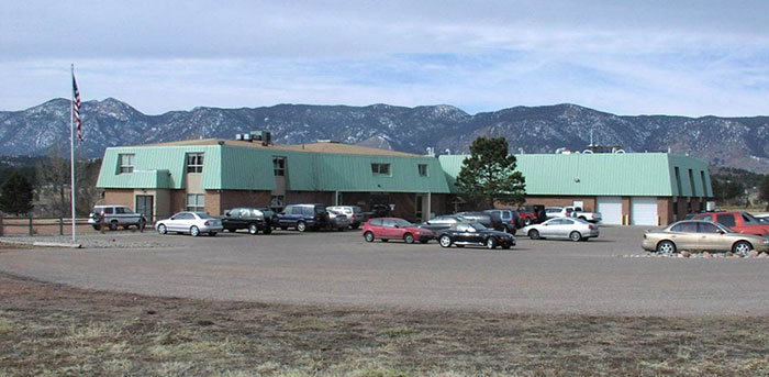
Navsys Corporation in Colorado Springs is located just outside the gates of the U.S. Air Force Academy, so it’s not unusual that its customer base reflects a close association with the U.S. military and its prime contractors.
When someone in the military had a challenging GNSS or related technology problem in the past, it was often Navsys who was able to offer an innovative solution, through a Small Business Innovation Research (SBIR) proposal — and the company was actually awarded nine SBIR Phase II contracts over the last five years. Phase II SBIR contracts are designed to transition mil technology into commercial products either via government organizations or commercial outfits. Often in the past, prime contractors responding to a larger mil-spec requirement would also roll Navsys into their response when part of the requirement involved a GNSS navigation or related solution. So since 1989, the development of GNSS technology and products, and the publication of papers describing those technologies and products, have been pretty continuous at NAVSYS:
Extended wide area differential GPS
WAAS bent-pipe signal generator (SIGGEN)
GPS/inertial video registration
Digital beam-steering GPS receiver
JLOC Jammer Detection and Location system
Indoor location
GPS phased sensor array
Software-defined receiver
JLOC has been a long-term active government project for more than 10 years. SIGGEN technology has been part of Japan’s MSAS system for more than 10 years, and is an example of a successful product that has transitioned from government research into the commercial sector. And, of course, the first GPS-enabled cell phone, developed by Navsys Corporation, is now on display at the Smithsonian National Air and Space Museum’s Time and Navigation exhibition in Washington, D.C. Developed for the Colorado Department of Transportation’s Emergency Vehicle Location System Mayday platform in 1995, this important step in GPS history paved the way for positioning to become an integral component of today’s communications technology.
The complement of professionals on staff at Navsys has changed throughout the years, driven largely by how many projects were contracted at any one time, but the group has always had a very high standard of qualifications and experience and has inevitably exhibited a large degree of flexibility and creativity. Nowadays, moving to better align with commercial opportunities, Navsys helps companies solve challenging problems relating to GNSS, inertial, and simulation/testing. Cultivating business-to-business partnerships allows the company’s technical expertise to compliment and strengthen end-user products or applications. So companies are able to use Navsys as a technical resource for product development at a lower cost than developing their own in-house navigation solutions. And many of the technologies and core capabilities that they turn to stem from prior research and development into government and military applications. As projects mature, they transition into industry-leading products and services. Navsys’ industry partners and customers then go on to customize these capabilities into commercial applications in the marketplace.
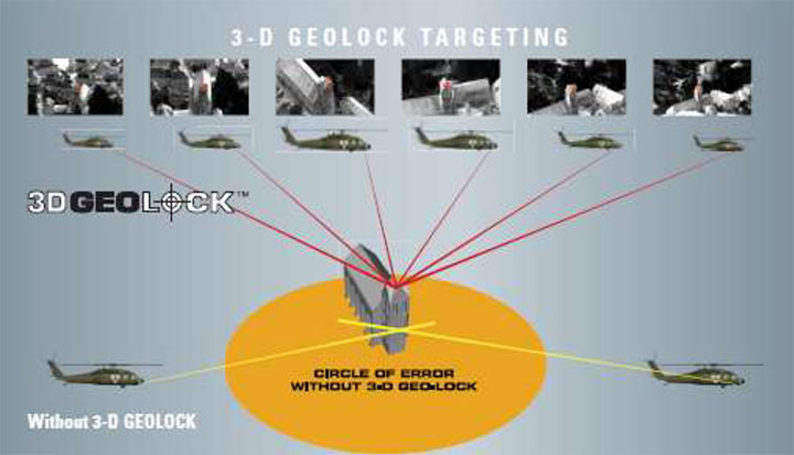
One of the key technology/products that Navsys is pursuing includes InterNav modular GPS/inertial embedded software. It provides a real-time tightly coupled GPS/inertial solution that can be precisely aligned with additional sensors, including digital video products and laser rangefinders.
InterNav software provides geo-registration for SAFIRE. Photo: NAVSYS
InterNav software may be embedded into OEM applications including commercial-off-the-shelf GPS/INS systems, unmanned platform navigation and stabilization systems, and remote sensing geo-registration. The above graphic shows how InterNav provides highly accurate geo-registration for FLIR’s Star SAFIRE electro-optic imaging system.
With other key customers such as KVH also using InterNav in some of its integrated inertial products, Navsys appears to be well on its way to penetrating a market segment that has previously been a space occupied by companies such as Applanix, Teledyne, and iMAR.
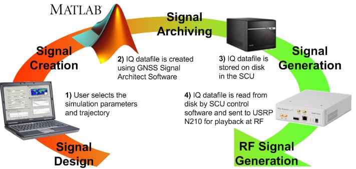
Another area where Navsys has had some success is GNSS simulation and test. The GNSS Signal Architect product suite includes Simulation and Toolbox software and test-set hardware.
Photo: NAVSYS
Simulations of GPS or GLONASS are created based on static or dynamic scenarios. Users specify a complete set of simulation parameters, including receiver/satellite profiles and delay/noise error modeling. Playing back the simulation as an RF signal provides accurate and repeatable signals for GNSS receiver testing.
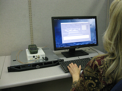
Signal architect user. Photo: NAVSYS
Toolbox includes a number of GNSS MATLAB utilities, including geographical, satellite geometry and receiver design/analysis tools. Test set is made up of a signal control unit computer and a software-defined radio and includes a wideband transceiver daughterboard.
Navsys has in the past provided extremely accurate GPS scenario generation software for end-user GPS simulator products, and the SatGen GNSS signal generator has also been released by Racelogic using Navsys Signal Architect Signal Simulation software.
Other technology/products currently in the works include Precision Geo-Registration and Remote Sensing, Geo-Referenced Imagery, Video-Aided Inertial Navigation and GNSS/Inertial Simulation.
GPS/inertial InterNav technology has been used to develop Precision Geo-Registration and Remote Sensing,which extracts precise coordinates from video imagery without requiring any known data points. The key technology advantage is a precision GPS/inertial alignment technique that enables accurate camera alignment and aiming (<1 mrad attitude) using only low‐grade inertial sensors.
Video-Aided Inertial Navigation uses an algorithm update technique that leverages image aiding from tracking ground points to further refine alignment accuracy. When combined with the GPS/inertial alignment algorithm, significantly improved alignment accuracy can be achieved over current GPS/inertial integration approaches.
Photo: NAVSYS
So, as defense spending continues to contract, Navsys and other similar companies with an existing “treasure chest” of technology created for previous military programs are successfully adapting. Not only are skillfully modified, repackaged or even further advanced technologies and products being brought to the commercial marketplace, but their approach to business development, marketing and sales is beginning to take on the face of commercial operations. Business plans, carefully chosen projects and internal investment are beginning to replace responses to Commerce Business Daily (CBD) and Federal Business Opportunities (FedBizOpps) as a way to conduct business. It’s a brave new commercial world out there and Navsys amongst others is ready, prepared and able to adapt and succeed.
Mapping turned up the heat in June, becoming a hot topic across the board. Apple ended negotiations to buy Waze, a provider of crowd sourced mapping and traffic, reportedly because the company did not want to relocate from Israel. Google quickly took Apple’s place as Waze’s buyer. With almost 50 million drivers using Waze, many via Apple Maps, Google would get another leg up in the race to own mapping. The connected car industry, gathered in Detroit last week, discussed the need for intelligibility in the market, particularly more organized categories of offerings. Also of interest this month is the backpack-mounted Google Trekker used to map the world where cars don’t go, as well as the LocationTech working group.
Surprisingly, reaction to Google’s sweeping design of new personalized maps, now in limited release, has been muted. The maps show landmarks, restaurants, and other details tailored to the user’s plans, habits, and interests that will become increasingly individualized with usage. One person’s map may include bars and public pools, another’s may include book stores and playgrounds. Google also introduced other map features like blending of Google’s place images, 360 degree views within retail shops, and 3-D satellite images of earth without a plug-in or download needed.
Connected Car Gathering. At Telematics Detroit last week, the connected car industry tried to reach much-needed clarity on the state of the connected car, with attention to standardization, consolidation, increased collaboration, and partnership. Many are trying to build a smartphone experience in the car but, “compared to a mobile phone, you’re always going to lose,” said Robert Acker of Harman. “The car is another device on the ‘Internet of Things,’ and we need to optimize that thing for consuming content while driving. Don’t make it a bigger smartphone device. That’s all Google or Apple can do. Rather, completely change the paradigm. Make it totally seamless; introduce gesture, head-up displays, steering controls. Make it truly revolutionized for the customer.”
Auto OEMs Are Changing Really. Smartphone-like capability in the vehicle is revitalizing the staid OEM industry and has encouraged car manufacturers to take more risk and speed up development time. It used to be de rigueur that a car maker would first pick a supplier like Denso to build a component, like a radio. “Now the automotive companies are first choosing a platform and layering on companies to build the solution. Tech companies are specialists,” says David Jumpa of Airbiquity. “We stand in the middle of the platform that makes it all work together.” Jumpa expects connected car services to get bundled and consumers to pay a subscription fee.
Freedom to Choose. To the unhappiness of wireless carriers, the automotive industry is planning on building cars with embedded subscriber identity module (SIM). Unlike current SIM cards that are carrier-specific, these are universal SIM cards that would enable customers to pick their vehicle’s wireless carrier and then change it at will. For OEMs, embedding SIM cards creates great efficiency. SIM cards can’t be easily replaced, as they must be soldered into vehicles because of vibration and shock. With OEMs shipping vehicles to multiple countries that have different carriers, a universal SIM card provides great flexibility and cost savings. Apple once tried to pursue an embedded SIM card and the carriers rose against it, but let’s see how the OEMs fare.
Mapping the World on Your Back. You’ve probably seen cars loaded with GPS and cameras for mapping streets. It is less likely you’ve seen mapping trikes, carts, or new photo-mapping backpack. Google uses the Trekker, a 42-pound backpack equipped with GPS and 15 cameras. Every 2.5 seconds it takes a picture as a person lugs it along trails, narrow streets, alleys, and mountains. Photos are stitched together to create panoramic images for StreetView.
Location Collaboration. A new initiative, LocationTech, has arrived on the location scene and is dedicated to individual and company collaboration on open-source software with an emphasis on location. The non-profit Eclipse Foundation, has created the working group LocationTech, led by Oracle, IBM, OpenGeo, and Actuate. LocationTech will allow companies to jointly develop and deploy components that bring location awareness to enterprise IT. “No single vendor can address the range of issues our LocationTech working group members are going to solve,” said Mike Milinkovich of Eclipse. “By creating a multi-vendor, open platform for location technologies, we intend to spur even broader adoption of location aware products, devices and services.” LocationTech might sound similar to the Open Geospatial Consortium (OGC) and the Open Source Geospatial Foundation (OSGeo); however, LocationTech offers full-service support and staffing for open-source location-aware technologies.
In the more than 100+ articles I’ve written for GPS World magazine over the past seven years, I don’t think I’ve ever written about a new product introduction like you will see below. I tend to focus on GNSS and geospatial technologies rather than a brand-specific products and services. In fact, last week I had an outline prepared for my article that included some really cool free and useful GPS/GNSS apps. I decided to set that outline aside until later, in favor of writing about this product.
Although certainly different than mainstream GPS/GNSS receivers, I wouldn’t refer to this new product as a disruptive one (a marketing term used to describe something that is industry-changing) and it doesn’t incorporate leading-edge GPS/GNSS technology. In fact, it’s relatively low-tech in comparison to the other GPS/GNSS surveying receivers available in the marketplace.
Even more fascinating is the fact that the product was developed not by any of the mainstream GPS/GNSS receiver manufacturers you hear about today, but rather an electrical engineer from Utah who leveraged the design/manufacturing expertise of one of China’s largest manufacturers of GPS/GNSS surveying receivers.
The final nail in the coffin is the fact that I’ve expended thousands of words in GPS World denouncing the future of post-processing and celebrating the virtues of high-precision, real-time GNSS (RTK, SBAS, PPP) receivers.
I tried to talk myself out of writing this article more than once, telling myself that I’ve never written specifically about a new product and I wasn’t going to start now. But, as much as I didn’t want to, I always came back because it is so darned compelling.
While the product is not aligned with my vision of real-time being the future of high-precision GNSS receivers, it is perfectly aligned with my vision that the cost of high-precision GNSS receivers are dropping and will continue to decline considerably over the next few years.
However…it is incredibly inexpensive, and it is designed to be perfectly simple to operate.
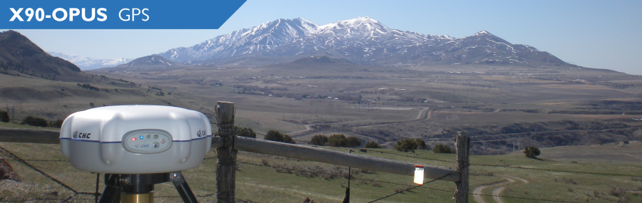
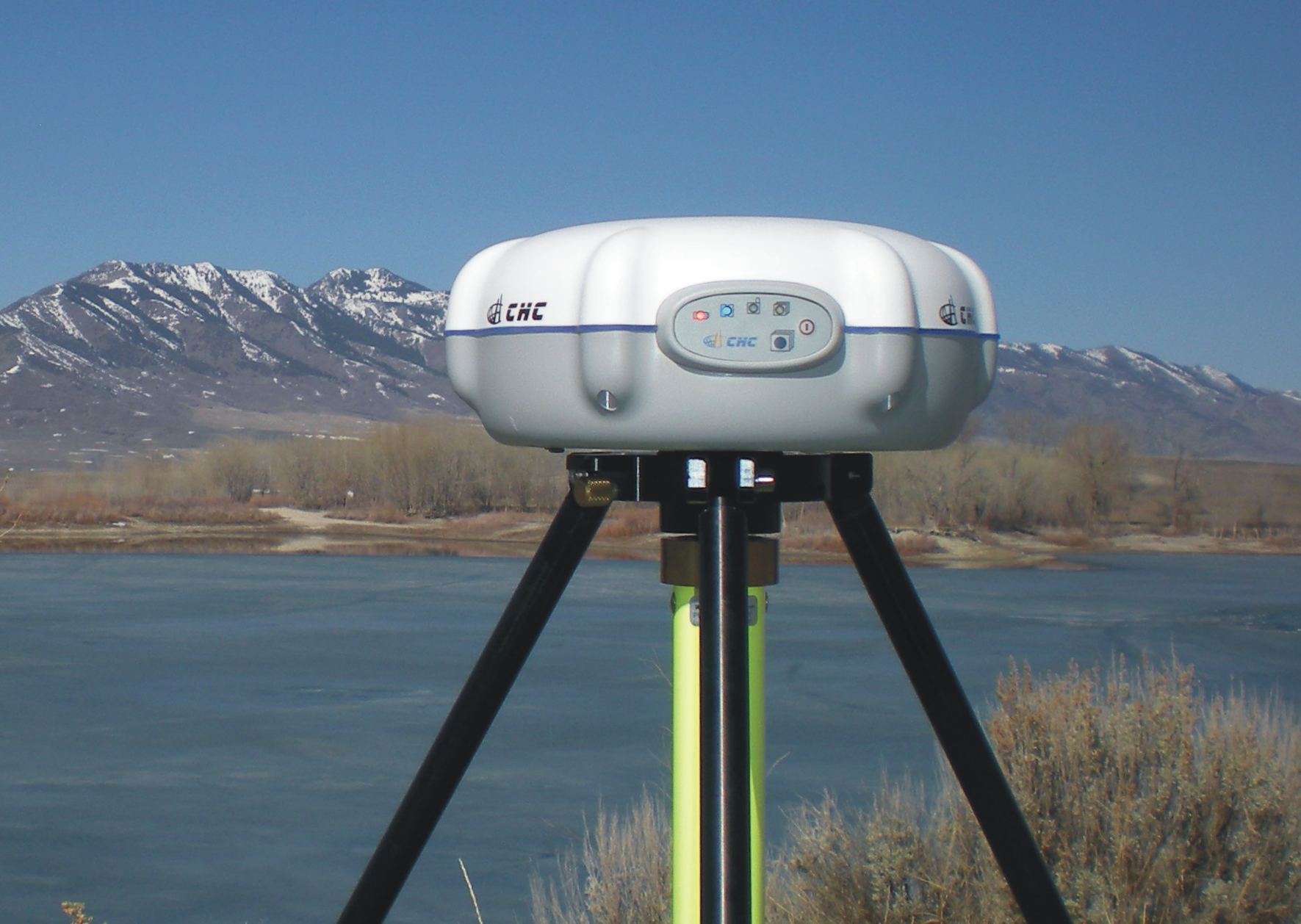
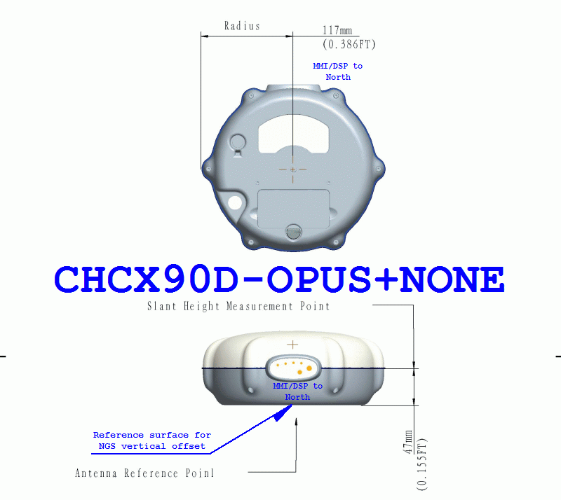
iGage X90-OPUS Photo: iGage
In one sentence, the X90-OPUS is a one-button, dual-frequency GPS receiver that is specifically designed to use the National Geodetic Survey’s free online OPUS post-processing service to achieve centimeter-level GPS positioning anywhere in the United States and surrounding countries.
You might say to yourself, “So what? There are plenty of GPS receivers on the market that are capable of providing this functionality.” I would make the same comment, except it has one product feature that I’ve never seen before.
The Price
What makes the X90-OPUS so compelling is its low cost. The X90-OPUS GPS receiver sells for US$2,450, including all software and accessories (except for tripod/tribrach) that allow you to submit GPS data files to OPUS in a very automated fashion.
At US$2,450, the X90-OPUS may open a new world for surveyors, engineers, and scientists who have previously shunned high-precision GPS receivers due to their high cost and complexity.
Simplicity
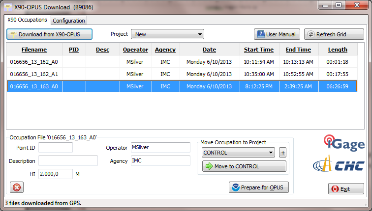
For those of you who yearn for the yesteryear of the one-button Ashtech’s legacy Locus GPS receiver, the X90-OPUS reminds me of that sort of simplicity, but on steroids. The X90-OPUS is a dual-frequency (L1/L2) receiver, while the Locus was a single-frequency receiver. The difference is that one can use OPUS and the other cannot. OPUS post-processing doesn’t support single-frequency GPS receivers. However, Mark Silver, the electrical engineer from Utah, has taken it a step further by developing software that automates the OPUS data submission process. Although I’ve made it clear in the past that I’m not a fan of post-processing, it doesn’t get any easier than this. You don’t need to buy a base station, and you don’t need to own post-processing software. It’s a two-button push operation: once to turn it on, and once to turn it off.
X90-OPUS Software Photo: iGage
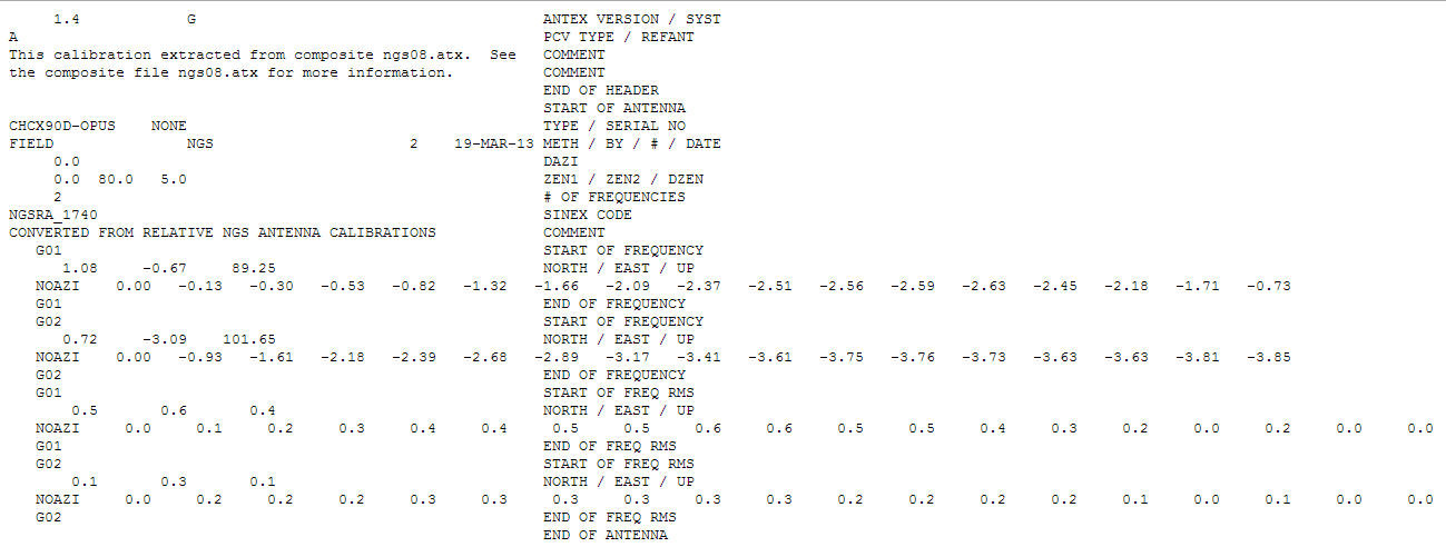
The X90-OPUS receiver was characterized by the National Geodetic Survey back in March 2013 and is listed on the NGS’s Individual Antenna Calibration website.
Photo: iGagePhoto: iGage
Pertinent Background
You might think that with the US$2,450 price point and not being offered by a major GPS receiver manufacturer, this is some home-brew GPS receiver. If you thought that, you would be incorrect. The GPS engine in the X90-OPUS is a Pacific Crest BD950, the same engine found in many receivers from other GNSS system manufacturers. CHCNav integrated the GPS engine into its casing to produce the X90 receiver. However, Mark added his own special sauce to the X90 to turn it into the X90-OPUS so this isn’t just a CHCNav receiver being marketed by iGage (Mark’s company).
In all fairness, I’ve not touched the X90-OPUS yet. I likely will in the next few days. However, unless the hardware is unreliable, I don’t see how this product is not going to be a winner, and it will introduce high-precision GPS receivers to an entirely new group of surveyors, engineers and scientists who have been holding out on using GPS.
Summary: A look at the challenge of dealing with horizontal datums in your GIS. We are moving into a new era in dealing with datum transformations. Geodata 2.0 is coming, and it can create big headaches when attempting to combine disparate geospatial databases. Sensors such as GPS receivers, remote sensing imagery, and 3D scanning provide much more accurate data, setting up a collision with outdated and mismatched legacy horizontal datums.
Speakers:
Kevin Kelly, Geodesist, ESRI, Inc.
Kevin Kelly is a Geodesist with ESRI in Redlands, California where he researches and implements geodetic algorithms and applications for the ArcGIS software. His experience spans over 35 years in hydrography, geodesy, surveying and most recently, geographic information systems. He has held the posts of Manager of Geodetic Services for the Province of Ontario, Chief Geodesist for the Kingdom of Saudi Arabia’s Military Survey Department and Senior Project Surveyor for The Keith Companies (now Stantec, Inc.). Mr. Kelly received a Master of Applied Science in Geodesy at the University of Toronto, Canada and holds an Honors Diploma in Hydrographic Surveying Technology from Humber College in Toronto. He is also a licensed Geodetic Surveyor in the Province of Ontario, Canada.
Craig Greenwald, Technical Director, GeoMobile Innovations
Craig Greenwald is the Technical Director and a principal at GeoMobile Innovations Inc. He has worked in the GPS and Mobile GIS industry for over 13 years, including seven years for GIS software leader, ESRI and is well known for his work on the ESRI ArcPad team. Craig leads the GeoMobile software development and consulting team specializing in Mobile GIS and field data collection applications and technology providing Mobile GIS software, consulting, and training services to GeoMobile Innovations? clients. Craig has real world experience designing, implementing, and consulting on all sizes of projects, ranging from local campground trash mapping to the U.S. national census, and has been a key developer in GeoMobile?s commercial applications such as LaserGIS for ArcPad and Geo-Photo Inventory Tool for Garmin GPS solutions.
Michael L. Dennis, RLS, PE, Geodesist, NOAA
Michael L. Dennis, RLS, PE, is a geodesist at NOAA’s National Geodetic Survey (NGS) where his duties include analysis of geometric (“horizontal”) and vertical datums; evaluation of data processing and survey network adjustment procedures; development and promotion of standards and guidelines; integration of NGS products and services with GIS; and public outreach. Mr. Dennis is also a registered professional engineer and surveyor with private sector experience, including ownership of a consulting and surveying firm. Mr. Dennis is an officer of the American Association for Geodetic Surveying (AAGS), an American Congress on Surveying and Mapping (ACSM) Fellow, and a member of the Arizona Professional Land Surveyors Association and the Geomatics Division of the American Society of Civil Engineers.
Moderator:
Eric Gakstatter, Editor of Geospatial Solutions Monthly and Survey Scene
Eric Gakstatter has been involved in the GPS/GNSS industry for more than 20 years. For 10 years, he held several product management positions in the GPS/GNSS industry, managing the development of several medium- and high-precision GNSS products along with associated data-collection and post-processing software.
I first met just-pinned-on, shiny and bright, Captain Bernard Gruber-USAF in 1992. Bernie had just arrived at the Space and Missile Systems Center at Los Angeles Air Force Base in California where he would hold several important positions.
For those readers not aware of the mission and importance of the Space and Missile Systems Center (SMC), today SMC, which began in 1954, is the nation’s center of technical expertise for military space acquisition with more than 5,000 employees nationwide and an annual budget of $10 billion.
Bernie’s first association with GPS at SMC was as the chief of User Equipment Production at the then NAVSTAR Global Positioning System Joint Program Office (GPS-JPO). He went on to serve as the program manager for Foreign Military Sales (FMS), working with our allies, and then as the program manager for Advanced Military Devices, which is a euphemism for things we can’t discuss in this venue. All this in a short 40-month time frame, which is almost as long as he has served in his current capacity as the director of the Global Positioning Systems Directorate, now 21 years later. As a young starry-eyed captain, I remember Bernie as energetic, dedicated and full of ideas, which pretty much describes him today as he completes his last active duty assignment and his 26-year U.S. Air Force career draws to a close.
While it may be fair to say that Bernie had some notion of what to expect when he was assigned as the commander of the GPS Wing in 2010, he actually had no idea of all the tremendous and mostly positive changes that would occur to the GPS program under his watch.
I thought it would be fitting to conduct an exit interview with Bernie during his last full month on the job and get his opinion concerning the changes to GPS during his tenure and the probable way ahead for GPS as he turns over the reins.
Don Jewell (DJ): Colonel Gruber, thanks for taking the time to speak with us today. I know you are extremely busy and your time is running short at SMC. Bernie, you have certainly lived the old Chinese adage, also sometimes described as a curse, during your tenure as the GPS Wing Commander and as the director of the GPS Directorate, “May you live in interesting times.” Your tenure has been beset with one major challenge after another and yet you have persevered and — I think this is something for which you will be remembered — you have consistently turned those challenges into opportunities. Let’s discuss some of the opportunities.
Certainly sequestration and budget issues are big topics today. Having come from the Pentagon and having worked on the financial side of GPS, were you surprised by what you found when you took over as the GPS Wing commander? Was it all you expected it to be? The big question seems to be, how is sequestration going to affect the future of the GPS?
Colonel (USAF) Bernard Gruber (BG): Well, Don, certainly budget issues are a key topic today, but let me say before we get started on the questions and answers that I really appreciate the opportunity to speak with you and your readers at GPS World. As you said in your introduction, these have certainly been interesting times. Some people may call it crazy but they are certainly interesting, nonetheless.
I must say that I was pleasantly surprised how much had changed on the [GPS] program when I came back to SMC, and the changes were really all for the good. It warmed my heart to see the Foreign Military Sales [FMS] office — which I actually started back in 1992 — now has agreements with 55 nations, and military sales continue to increase year-by-year. I was also very happy and surprised to see the SAASM or Selective Availability and Anti-Spoofing Module program, which I was actually the program manager for in its infancy, has now been installed on over one million GPS military receivers — in my estimation this program is protecting warfighters around the globe every single day. I think that is something we can be very proud of together.
The folks in the [GPS] Program Directorate that I have had the good fortune to work with are really something special. They work their hearts out every single day to protect, modernize, and sustain this great system. Also, I continue to be very much amazed that people understand the value of GPS as part of our critical infrastructure. So, my thanks to folks like you, Don, and the folks at GPS World for educating the public on this great utility that we have.
DJ: Thank you, Bernie, for those kind words. You know we are always happy to serve.
BG: Moving on to the sequestration bill… We are working very hard to reduce our costs and invest in different opportunities that have a return on investment like dual launch [of GPS III — ed.] and NavSat, or I think it is NibbleSat, as you and Dr. Parkinson referred to it in your article from the National Space Symposium, which we look at as an augmentation to GPS III. That is a good thing because it can significantly reduce total lifecycle costs of the program. So we continue to look at these, amongst other items, that we will prioritize and spend our development dollars on — items such as Lithium Ion (Li-Ion) batteries, smart solar arrays, that allow you to have more efficient use of power, more efficient power amplifiers, that are significantly shrunk down in size from what we have today. Bottom line is we will continue to work on processes that clearly show a positive value stream.
DJ: I would think that one of your bigger, albeit not technical, challenges during your tenure was transitioning the GPS Wing back to an SMC Directorate. Any thoughts about the wisdom of that transition? Has it affected operations in a positive or negative way, or can you detect a difference? Has it affected the space career field for your military members?
BG: I remember you asking me this very same question back in 2011 during our very first interview, and I wish I remembered [ed. We remember — click the link]what I said back then, but I will give it a shot from where we are, right here, right now (laughs).
General Sheridan, as you very well know, the prior SMC Commander, had actually given me six goals when I got here. The first of those was fix the gap between OCX and GPS III. If you recall, we had about a 15-month gap in the delivery of those items. The second one was he asked me to transfer the AEP and LADO[launch, early orbit, anomaly and disposal operations, now provided by Braxton Technologies] ground segment to our users [the 50th Space Wing] and get that capability to them as soon as we could, so that they could operate it and own it. The third one was fix the IIF production line. The fourth one was to get the MGUE, or military GPS user equipment, back on track and award contracts. The fifth one was build a relationship and continue that relationship with the 50th Space Wing [Schriever AFB, Colorado]. The last one that he actually gave me was to ready the first space vehicle for GPS III through the GNST, which of course is the GPS III Non-Flight Satellite Test Bed and an engineering, manufacturing and development pathfinder for the GPS III program, used to achieve modernization. And, Don, I am happy to say that we as a team have achieved every one of those goals.
Not far behind those goals, Don, General Sheridan followed up with the task of transitioning the Wing back to the Directorate. And as far as I can tell, it has really been seamless. I have to say, though, I really miss the instant recognition that we, as airmen first and then as acquisition professionals, had when we were called Squadrons, Groups and Wings. While I certainly understand that the number of folks that we supervise may have not have justified those titles by themselves, the level of responsibility that we have and my peers have around here certainly did, in my opinion. All around the change has not affected us in any negative way, and I really don’t detect any significant difference resulting from that transition.
DJ: Bernie, you oversaw the first successful launches of the Boeing-built GPS IIF satellites — a program beset by significant schedule and costs issues. Yet it has evidently become a success under your watch, even though there are still some issues. What are your overall thoughts about the IIF program?
BG: Thank you for that, but I really share this success with many, many other people here at SMC as well as at Team Boeing. The IIF program really and truly has turned a corner. It’s delivering world-class position, navigation and timing (PNT) data right now for users all over the world. Under my watch we had the addition of three IIF satellites actually put into the active constellation today. And although a lot of people may not know it right now, we recently achieved our very best day ever on the 21st of April in terms of accuracy of the GPS signal, with average user range errors (URE) of less than 51 centimeters. That is really astounding! It is better, clearly better, than any PNT system in the entire world today.
So the IIF program, at this point, is focused on closing out the production line and certainly completing those remaining few satellites. We will ready those eight satellites for launch, and then we will support the existing on-constellation needs as they arise.
Now, the nature of space programs is such that technology issues can, of course, creep up on you at any given time. I think we have proven that we can meet those issues head-on and keep the program on track. I could not be prouder of my IIF team very specifically. I very much recall when I first walked into this program office, when we had to actually shut down the IIF production line for over a month. That was a hard thing to do, but it really focused us on closing all the discrepancy reports we had and modeling a very smooth production flow.
So, here we are now with four [GPS-IIFs] on orbit, and five in the barn. As far as I can tell, programmatic and technology challenges have really pretty much been abated to continue to allow world-class spacecraft and mission data as we look forward.
And, Don, let me also add that we successfully transitioned at that time the entire ground segment, the LADO system, which I know you are very familiar with, the systems training system, as well as the data archival system to our operators and partners at the 50th Space Wing, without one single lien.
DJ: Bernie, what you just told us is very impressive. Accuracy and standardization are critical to GPS program success, and it sounds like you have that well in hand. Of course, the seamless transition of key responsibilities to the 50th Space Wing and 2SOPS (2nd Space Operations Squadron) is to be applauded. Plus, it really appears you have the IIF issues resolved and the GPS III program has become a reality during your tenure. What are your hopes for that program? Do you think the Lockheed Martin built GPS III will truly, as some have predicted, become the first 30-year GPS satellite?
BG: The bottom line is that I sincerely hope that the GPS III program will be a benchmark for future space acquisition programs, both in terms of the high standards that were set for mission assurance, and the level of communication between our program office and the contractor. The GPS III program is entering the very early stages of testing right now on the first flight vehicle, and I anticipate that we will begin to see the program move down that learning curve in very short order. You know with the 15-year design life, which we put in the contract, along with stringent parts requirements and our priority on systems engineering, I really do expect that the GPS III satellites will operate beyond the standards set by the current constellation. And I do have to say that what we call our “back to basics” approach, that other folks have written about, which includes those attributes of strong systems engineering discipline, detailed manufacturing systems readiness reviews, and strict adherence to standards, are actually now showing tangible and documented results. In some cases a 60-percent reduction in our cycle time and a 70-percent reduction in discrepancies for the next delivered items. I think that is huge.
You know, even from an historical perspective, our pathfinder vehicle, which we talked about earlier, called GNST, has taken actually one year out of labor and interference testing from troubleshooting we have seen on two previous programs alone. So we are taking GNST through all the steps the very first GPS III satellite will be exposed to. Then we will ship it down to the Cape [Canaveral] in one month and we should be able to complete our initial and final look at integration and delivery.
DJ: Bernie, so far we have talked mainly about the successes in the space segment, while the future of OCX to many still seems very uncertain, especially in light of the latest GAO report, which had some serious issues of its own. You have been closer to this process than anyone. What are your thoughts? Does OCX have a future? There are rumors there are going to be major changes. Any announcements you would like to make or predict?
BG: The development program for the Next Generation Operational Control System has made significant progress, and has just recently completed a very critical Milestone B approval, in November 2012. As we stand right now, the program is poised to deliver the next-generation GPS space vehicle command and control capability, mainly for GPS III, of course. It will replace our legacy ground [command and control] system and will support legacy and future space vehicles, as well as all the signals that accompany them. The program at this point remains on track to deliver capabilities according to the acquisition program baseline that we set down during the recent milestone.
That said, Don, some of the recent and heavy work of information assurance criteria are extremely rigorous. In fact, they are the most rigorous I have ever seen on any program that I have been involved with. Someone once told me a few months ago, “Bernie, you know you are building an information fortress that just happens to do Command & Control.” So I don’t know if I actually subscribe to that thought, but I think it gets the point across. In today’s cyber-threat environment, we have to do this, and we have to do it right for the protection of GPS.
To give you some confidence in the program, as of today we have actually coded over 98 percent of the Block Zero system, which is the basis for launching and commanding the basic GPS III constellation and, of course, the first vehicle. And we followed that up with two very significant exercises to provide telemetry and an integrated planning system. In July, we will actually go forth with our third exercise itself. In fact, I just got off the phone with the team a few minutes ago, to exercise what we call off-nominal behavior. Those are different types of test plans we have to go through just in case something in the system goes wrong.
What that means, Don, is if something does not go according to plan, what we do is we inject faults into the system and other types of non-nominal behavior, and then we see if we can do recovery actions and how the command and control system will actually fix it and correct it. This ensures the operators will have the tools to fix it.
So, Don, as kind of an overview, along with what we call the complete authority to test the documentation that is in place right now and the conclusion, which we recently had, of our third critical design review, I think we are on our way. We will be challenged along the way, there is no doubt about that, but we are looking forward to achieving our full capability with Block One. [ed. OCX Block RTO currently scheduled to be delivered in Q1 2017.]
DJ: Bernie, that is great news for those who are worried about the future and viability of OCX. It is good to know you still see a way ahead. Now we have covered the three main segments of the program, but there are still concerns over the initial acquisition process and how that plays out over time. Certainly in your career you have been steeped in Air Force and DoD acquisition programs for years, which is a process many in government describe as a process in need of a major overhaul. What are your thoughts? How could we, the government, the USAF, do things differently? Any solutions or cogent thoughts?
BG: Sure, off the record! No, seriously, I have indeed been involved in acquisitions for a long time now, and let me just say that is a great question and it is certainly deserving of a much, much longer answer than I have time to provide for you here today. As a matter of fact, I have written a couple of papers on the subject of acquisition reform in the past, and I have been involved with three very significant studies in Defense Acquisition University (DAU) as well as one of our nation’s premier think tanks, the Center for Strategic and International Studies in Washington, D.C.
But, in my opinion, there is a lot we can do, so let me just capture a couple of thoughts here. The first one, and I have noted this one many time before, is funding and requirements stability, both in what we call the program stages and execution stage of the program, is just paramount. That said, I fully realize with sequestration and budget control measures that we cannot control budget releases from Congress, cuts or changes. But it really does create an incredible burden on our ability to deliver systems on time. The second is one is to look seriously at decentralizing execution. As has been cited in many studies before, whether those be “Beyond Goldwater-Nichols” or the DAPA Study (Defense Acquisition Performance Assessment) that some people call the General Kadish study, it is easy for anyone along the long chain of acquisition approvals to say no or to add another layer of documentation or to change, but the ripple effect of doing that as well as what it does to the system is just overwhelming.
And I will say that as our Air Force Space Command commander (AFSPC/CC), someone who I know both you and I respect very deeply, General William Shelton, often says, “You know these times come with great opportunities and we need to seize upon them.” I couldn’t agree more with him.
DJ: Colonel Gruber, I assume you have had at least a few moments in your hectic schedule to reflect on your tenure at SMC and the GPS Directorate, so as we wind down today, can you describe your high and low points in the job? Would you in hindsight do anything differently?
BG: I think that is a great question, and I will say in all sincerity that there have actually been very few low points on this job, but there have been a couple. As you know, it has been frustrating for me to see civilian funding on GPS not come to closure. We have taken very large cuts over the last couple of years, and I am really not sure that the future is any more certain. I am not sure where we stand right now. This has a combined effect of increasing risk and potentially delaying the OCX program capabilities. Also, I was disappointed, quite frankly, to not be postured adequately to get a multi-year buy for the GPS III satellite system this time around for satellite vehicle nine and out. I truly believe that we can greatly reduce our costs through stable production line, an increased learning curve, correct incentives, and a large block buy. I really think we are going to get there, but I would really liked to have gotten this done before my successor, Colonel William “Bill” Cooley, arrives here in about a month.
As far as the high points go, Don, there are literally hundreds — seeing our folks get promoted, supporting the community activities here at Los Angeles Air Force Base, and of course the mission successes that we have enjoyed. These include, of course, the recent and successful launch of the IIF-SV4 on the 15th of May. Increasing the dependability of the GPS ground segment, and that is an actual measure, to 99.34 percent, which, by the way, is the best it has ever been in the history of the program. Awarding new contracts for on-orbit support and ground contracts that have reduced our contract costs by almost 50 percent. Another one is locking in three vendors to be able to build the next generation of GPS [ed. military] user equipment, and of course the achievements of the SMC commitments that I mentioned earlier and those that General Pawlikowski [SMC Commander] have laid out for us for the future.
So, in the big scheme of things, I am not sure that I would have done anything different, but the truth is, Don, it might take a little bit more reflection on my part, and I might answer that differently sometime in the future. But for right now I feel very confident with what we have done and very proud of what the team has taken forward with me.
DJ: Colonel Gruber I want to thank you very much for your time today, for your dedication to the GPS mission and for your service to your nation over the last 26 years. Now, this is your opportunity for a parting message and a chance to fill us in on what your future holds.
BG: I am not sure I have a parting message for you. Truth be told, leaving this program, the people in it and the great service our country provides through GPS is going to be hard to do. My three years is up, and I will be retiring from the USAF after 26 years of service. It has been a great ride. I applaud the efforts of you and your readers, our contractors, our government employees, and our international partners, of course, who continue to overcome adversity and invent new applications and services for GPS. But most of all, Don, I really want to thank the men and women who serve in deployed regions of the world. They are putting their lives on the line every single day. We owe it to them to have this system to be able to support them, anytime and anyplace.
And as to my future — I actually leave the Air Force with a smile on my face, it has been a great ride. After many discussions with my family, we are heading back to our roots in Minnesota. My wife and I are very fortunate to be able to make the decision to spend time with our parents and our families and relatives back home in the St. Paul-Minneapolis area.
DJ: Well, Bernie, I am totally surprised. I don’t think I ever heard you say, “ja shure, you bet, you know” once in all the years I have known you.
BG: Ya know, Don, I can really lay it on pretty thick when you need me to, ya know. [ed. Saying this, Bernie sounds exactly like an extra in the movie Fargo.] But seriously, we are going to spend some time with family and take it easy for awhile, and then I will explore future opportunities.
And with that comment, we wish Colonel Gruber the best of luck in the future. That’s a wrap for this month. Next month we will review some of the latest and best user equipment for our warfighters, government users, and critical first responders. So until next time, happy navigating.
This week’s Defense PNT newsletter by GPS World contributing editor Don Jewell carries an exit interview with Col. Bernard “Bernie” Gruber, who is leaving his post as director of the GPS Directorate after more than three and a half years in that position, and concluding his 26-year U.S. Air Force career. Look for the full interview later this week on the Defense PNT newsletter page. To receive subsequent issues of this monthly e-publication subscribe free here.
Here is an advance look at the extensive interview with a few selected quotes from Col. Gruber:
“We are working very hard to reduce our costs and invest in different opportunities that have a return on investment like dual launch [of GPS III] and NavSat, or I think it is NibbleSat, as you and Dr. Parkinson referred to it in your article from the National Space Symposium, which we look at as an augmentation to GPS III. That is a good thing because it can significantly reduce total lifecycle costs of the program. So we continue to look at these, amongst other items, that we will prioritize and spend our development dollars on — items such as Lithium Ion (Li-Ion) batteries, smart solar arrays, that allow you to have more efficient use of power, more efficient power amplifiers, that are significantly shrunk down in size from what we have today. Bottom line is we will continue to work on processes that clearly show a positive value stream.”
[ . . . . . ]
“General Sheridan, as you very well know, the prior SMC Commander, had actually given me six goals when I got here. The first of those was fix the gap between OCX and GPS III. If you recall, we had about a 15-month gap in the delivery of those items. The second one was he asked me to transfer the AEP and LADO (launch, early orbit, anomaly and disposal operations) ground segment to our users [the 50th Space Wing] and get that capability to them as soon as we could, so that they could operate it and own it. The third one was fix the IIF production line. The fourth one was to get the MGUE, or military GPS user equipment, back on track and award contracts. The fifth one was build a relationship and continue that relationship with the 50th Space Wing. The last one that he actually gave me was to ready the first space vehicle for GPS III through the GNST, which of course is the GPS III Non-Flight Satellite Test Bed and an engineering, manufacturing and development pathfinder for the GPS III program, used to achieve modernization. And, Don, I am happy to say that we as a team have achieved every one of those goals.”
[ . . . . . ]
“I sincerely hope that the GPS III program will be a benchmark for future space acquisition programs, both in terms of the high standards that were set for mission assurance, and the level of communication between our program office and the contractor. The GPS III program is entering the very early stages of testing right now on the first flight vehicle, and I anticipate that we will begin to see the program move down that learning curve in very short order. You know with the 15-year design life, which we put in the contract, along with stringent parts requirements and our priority on systems engineering, I really do expect that the GPS III satellites will operate beyond the standards set by the current constellation. And I do have to say that what we call our “back to basics” approach, that other folks have written about, which includes those attributes of strong systems engineering discipline, detailed manufacturing systems readiness reviews, and strict adherence to standards, are actually now showing tangible and documented results. In some cases a 60-percent reduction in our cycle time and a 70-percent reduction in discrepancies for the next delivered items. I think that is huge.”
Several weeks ago I attended the ESRI Federal Users conference where Jack Dangermond announced his agreement with Digital Globe to supply the company’s extensive image library to ESRI users. Under the agreement, Digital Globe, which recently merged with GeoEye, is providing its historic imagery library along with very current imagery that is near real-time. The coverage map Jack showed and seen here was quite extensive and covered significant areas around the globe. This prompted a discussion with a long-time GIS colleague, Nancy von Meyer, who suggested that it sure would be nice to have a column that sorts out the current major imagery providers with the pros and cons of the various products and services. So here it is.
In the mid-eighties, when I retired from the Navy and started my second career in GIS, very few users had access to geo-referenced imagery other than intelligence agencies. By the mid-nineties, that changed as digital aerial imagery became cost effective and usable for heads-up digitizing and GIS base map creation. Now there are many imagery collection firms with a lot of content being provided seemingly for free. Too often I’ve heard GISPs fighting budget battles with push-back from non-GIS staffers that goes something like this: “Why do we need to pay for imagery when we can get Google for free?” Some of the following information and samples may be useful if you need to explain why.
The ASPRS (American Society for Photogrammetry and Remote Sensing) Ten Year Forecast and Survey is a superb source of imagery statistics and trends. Charles Mondello, the project team chair and ASPRS Fellow, highlighted several key points in the survey. By an overwhelming margin, respondents listed ortho imagery as the single most important layer in their GIS work. They also cited the following factors as most critical in making the imagery useful: resolution, positional accuracy, coverage and currency.
Google and Bing
Most ortho imagery is captured by satellites or aircraft and is the dominant type of imagery in use today, with many free sites such a Google or Microsoft Bing offering this imagery. Both websites understand that the better the users’ experience, the more traffic the sites will generate, so they are motivated to constantly improve and update the information. Among the new features being announced by Google is collation of imagery from Google Earth, Google’s Street View, and special projects including its space and underwater imaging. Instead of having to bounce around between products, you’ll now be able to get all of that in one place. Google provides significant support for non-profits and NGOs to map activities worldwide, which builds use and Google’s reputation.
However, the old adage “You get what you pay for” holds true with imagery. If you just want to look at stuff, both Bing and Google are fine, but we must all understand the limitations. By their own admission and licensing agreements, neither Bing nor Google claim to be authoritative GIS data sources. Both are extremely good, but designed for entertainment and to attract users to their sites to expose them to advertising.
A common complaint from Bing and Google users is that they are composites of many different data sources, and they have neither the time nor the need to organize and publish metadata regarding positional accuracy. Metadata is available but very difficult to access. Users cite positional accuracy estimates of Bing and Google of RMSE of +/- 10 meters. Another issue for federal users is FARS and licensing restrictions. So make sure your legal staff reads the fine print.
Certified ortho rectified aerial imagery
On the other end of the quality and cost spectrum is certified ortho rectified aerial imagery. Well-known companies such as Sanborn, Woolpert, Dewberry, MJ Harden, and a host of smaller aerial imaging firms provide top-notch imagery by contract for specific areas. Ortho rectified aerial imagery is scale-accurate images that have been corrected horizontally and vertically to account for variations in the terrain. Combining digital aerial images with digital terrain models can cause distortions of elevated features such as buildings, bridges and overpasses. These distortions are corrected during the ortho rectification process. Here is an example from MJ Harden Associates, Inc. showing pre- and post-correction imagery. This is a labor intensive process and not cheap when combined with surveyed ground control, but the end result is a very accurate image on which GIS users can do heads-up digitizing to produce accurate base maps.
ESRI and DigitalGlobe
In the middle are imagery vendors that capture imagery for resale and distribution such as DigitalGlobe and others. Some of the imagery is the best currently available, with excellent resolution and positional accuracy and easily accessible and complete metadata. Using the Identify tool in ArcMap or ArcGIS Online, users can see the resolution, collection date, and source of the imagery at the location clicked. Here is a short matrix of imagery sources and characteristics.
Authoritative data vs. Visualization products
It’s very important that we GISPs are mindful of the critical differences between “products” such as DigitalGlobe imagery purchased or delivered via ArcGIS, Bing and Google, and “services” of licensed engineers and photogrammetrists. Many imagery products are superb visualization tools, but should not be confused with authoritative datasets delivered through a licensed and certified process. There is an excellent comparison chart published by the ASPRS that compares the difference between products, professional services and technical services. If your application is critical and has the potential of legal liability, you may want to have your legal department review and understand the differences. It could save you from the false economy of getting cheap or free imagery.
Some examples
The following are some examples of old and new imagery since 1999. This is a non-scientific sample using a piece of property that I bought years ago near Lake Guntersville, Alabama. I’m using it because I know exactly when improvements were made so I can judge the accuracy of the date stamps shown with the images.
Here is the property shown on county-purchased 1996 panchromatic one-meter imagery.
Here is the same property with county purchased 2001 color 2’ imagery.
This Microsoft Bing Image was taken in early 2011 after a cabin was built but before a garden shed and driveway ramp were added. Looks like 1’ imagery supplied by DigitalGlobe but tagged in Bing as 2013.
Google has the most recent imagery, tagged as 2013 but most likely taken in early 2012. This DigitalGlobe imagery looks the best. I’m guessing 6” imagery, but the address marker is off by about 300’. Not terrible in this area, but could be a real problem with a row of houses.
So which imagery is best?
That depends on how you plan on using it. Bing and Google have become so good and ubiquitous that it’s easy to forget that they make no warranties regarding the data quality or suitability for your use. If you are showing friends the location of your favorite fishing spot or displaying a route to a restaurant, Google or Bing will be just fine and most likely better than a boring certified ortho-rectified image. But if the application is critical and puts your organization in legal crosshairs, you may want to use authoritative data produced through a licensed and certified process that has documented metadata.
A good real-world example that I observed several years ago was a failed drug raid in a county near Atlanta. The drug dealers got wind of a potential raid and cleverly switched numbers on their mailbox with a neighbor. The SWAT team did their initial planning on Google and raided the wrong house based only on the mailbox number. Although no one was hurt or killed, the resultant judgment cost the county more than $1 million. That police department no longer relies on free online maps and house numbers. They verify the information using authoritative county 911 data, parcel maps and imagery along with street-level surveillance photos. This was a very costly mistake that might have been prevented. Hopefully your county or agency has heard about this raid and has learned from that mistake.
With the significant expansion of oblique and 3D players, next month I’ll review this growing visualization technology.
UPCOMING GIS WEBINAR
GPS World’s next webinar, “Nightmare on GIS Street: GNSS Accuracy, Datums and Geospatial Data,” is accepting registrations. The webinar will be held Thursday, June 20, 10 a.m. PDT / 1 p.m. EDT / 6 p.m. GMT. Registration is free.
“‘Nightmare on GIS Street: GNSS Accuracy, Datums and Geospatial Data’” is a look at the challenge of dealing with horizontal datums in your GIS,” explained moderator Eric Gakstatter, survey editor and editor of Geospatial Solutions. “We are moving into a new era in dealing with datum transformations. Geodata 2.0 is coming, and it can create big headaches when attempting to combine disparate geospatial databases. Sensors such as GPS receivers, remote sensing imagery, and 3D scanning provide much more accurate data, setting up a collision with outdated and mismatched legacy horizontal datums.”
The Institute of Navigation’s (ION’s) advance program for the 2013 GNSS+ conference in September arrived in the mail the other day, and was avidly consumed. The technical sessions of this gathering are prime hunting ground for presentations that later become articles in this magazine, as are, to lesser extent, those of the European Navigation Conference, the Joint Navigation Conference, CTIA, ITS World Congress, and others.
Something struck me as I scanned the 280-odd presentations listed under 36 session tracks: the frequency with which the word BeiDou appeared. To determine if there were any substance to this fleeting impression, I essayed a quantitative analysis. Naturally, GPS and the generic GNSS occurred times beyond measure, but this is how the others fared.
What does this signify? Little enough, possibly. Still, something. A satellite navigation system bursts seemingly out of nowhere and within a few short years virtually laps the field, putting 20 (14 usable) transmitters into space and establishing a regional operating capability, soon to be global. That sort of thing tends to get noticed.
The titles of BeiDou-focused papers on tap this fall in Nashville — not all of them springing from the laptops of Chinese engineers, not by a long shot — add substance to this passing fancy.
◾ BeiDou Consumer Receiver Chips at Last.
◾ A Combined GPS/BeiDou Vector Tracking Algorithm for Ultra-tightly Coupled Navigation Systems.
◾ Towards the Inclusion of Galileo and BeiDou/Compass Satellites in Trimble CenterPoint RTX.
◾ New Assisted BeiDou Products from JPL’s Global Differential GPS System.
◾ BeiDou Integration in Cell Phones and Tablets.
◾ BeiDou — A System That is Now Ready for Applications.
◾ Augmenting GPS RTK with Regional BeiDou in North America.
◾ New Systems, New Signals, New Positions — Providing BeiDou Integration.
The affiliations of some of the authors of the above read like a top-level directory of North American and European GNSS manufacturers. Clearly, the ground has been plowed and the fields lie ready — if they are not already planted. Unless that’s too mixed a metaphor for satellite radionavigation signals.
The recent acquisition of one Western GNSS manufacturer by a major Chinese business concern has not gone unnoticed, either.
For more intelligence, I consulted the newest member of this magazine’s Editorial Advisory Board. He replied to my emailed penny for his thoughts.
“I would be happy to contribute a column for the July issue based on my observations here at the China Satellite Navigation Conference in Wuhan. The article would be titled: Little Tigers versus Wolves.”
A March 2013 report from the Government Accountability Office (GAO) seems to claim that the projected cost of the next-generation GPS ground-control system, known as OCX, increased by 43 percent, or $1 billion over the past year, to a total cost estimate of $3.7 billion. As GPS World contributing editor Don Jewell wrote shortly after the GAO release, “In fact, the report does not actually say that exactly, but you have to dig deep to determine that. Most readers won’t take the time to do that and will assume that the OCX program is grossly over budget. It is not.” A Raytheon spokesperson pointed out that the basis for the program cost estimate goes far beyond the scope of the original 2010 Raytheon prime contract of $886.4 million, and that the current value of the company’s contract is $969 million.
Design requirements for OCX call for it to support the GPS III constellation’s stringent accuracy, anti-jam, and information assurance requirements. The system is also to be backward-compatible with current GPS satellites. The original contracted carried an initial delivery date of 2016. At least some of the government-specified revisions in the contract come in the context of the need for absolute information assurance, given the Internet- and associated computer program-hacking by foreign sources, considered alongside the vast user base supplied by GPS, including the U.S. military’s reliance on its capability for many functions.
Kevin Ramundo, Vice President for Communications, Raytheon Intelligence, Information and Services, commented:
“GPS modernization through the launch of GPS III satellites and the GPS OCX ground system will provide new mission-critical capabilities to war fighters and additional capacity to meet the needs of millions of additional GPS users each year.
“Since the initial contract award, Raytheon’s GPS OCX program has made considerable progress including Milestone B approval and the successful completion of two ground station/satellite integration exercises. Nearly 50 percent of the software development is complete.
“With regard to the GAO report, it is important to note that the basis for their program cost estimate goes far beyond the scope of the Raytheon contract. In 2010, the contract award to Raytheon for GPS OCX was $886 million. The current value of our contract is $969 million, which now includes additional scope such as launch and check-out capability, tech baseline, and special studies.”
In December 2012, Col. Bernie Gruber of the U.S. Air Force GPS Directorate wrote in the pages of GPS World what was the commonly accepted perception of and public government position on OCX:
“Along with a host of additional satellite capabilities and signals, we will correspondingly modernize our ground segment. Our Next-Generation Operational Control System (OCX) is designed to command and control our modernized secondary civil signal L2C, safety-of-life signal L5, and the internationally compatible signal L1C. . . . . . As the modernized signals become operational, users will see faster signal acquisition, enhanced reliability, and a greater operating range. The information assurance, expandability, and service-oriented architecture will afford users and operators with security and information they simply don’t have today.”
The View from 2013. The 190-page GAO report, “Defense Acquisitions: Assessments of Selected Weapon Programs,” states that the scope and complexity of key OCX program elements was underestimated, and alluded to overruns that have historically beset Pentagon space programs.
specifically address OCX, which is identified as one of 19 weapons “Programs That Entered Development with Technologies Fully Mature or Nearing Maturity” and one of 14 “Programs with technologies nearing maturity at knowledge point 1 date.” OCX is given a knowledge point 1 date of November 2012.
According to the Report, “Air Force officials recently stated that, although GPS III is still maintaining an April 2014 “available for launch” date for the first satellite, the planned launch date is being moved to May 2015 in order to synchronize it with the availability of the GPS Operational Control Segment (OCX) Block 0, without which the satellites cannot be launched and checked out.”
“The program has experienced significant requirements instability and schedule delays while in technology development,” the report reads. “The contractor initially underestimated the scope and complexity of the necessary information assurance requirements which required additional personnel with the necessary expertise and increased government management.”
Changes in Specifications. In June 2012, a Raytheon executive stated that the OCX contract had been significantly modified, with the addition of a launch and checkout capability that had previously been the responsibility of Boeing, prime contractor on the GPS IIF satellites.
He also identified information assurance, a primary OCX requirement, as “a big challenge. It is very important that we protect this system against the current and evolving cyber threats because they are real and the nation can’t afford to have this system compromised.”
An Update Last Autumn. In a November 2012 conversation with GPS World defense editor Don Jewell, Raytheon VP and Program Manager for OCX Ray Kolibaba made the following remarks:
“We currently have 450 people at Raytheon working OCX, and with our subs, an additional 300 personnel. Altogether we have 750 personnel working GPS and OCX issues. This does not include the military and civilian personnel at Air Force Space Command and Space and Missile Systems Center.”
[ . . . . ]
Headshot: Ray Kolibaba
“Basically we are nearly on cost for the OCX contract. The current contract value is $925M; the original cost estimate was $886M. We are driving forward on that and the Block 1 date or Ready to Operate (RTO) date. Right now, the customer team is working on finalizing a new enterprise schedule that will show the Program Management Directive dates. So, we don’t know the exact date the government envisions. I expect an official date either late this year or early next year. I encourage you to ask Colonel Gruber [U.S. Air Force GPS Directorate] this question, and maybe then we will also get an answer. We have given them our recommendations.
“Concerning sequestration, I am not worried. I believe we have a reasonable level of support from Congress to maintain and continue OCX. That doesn’t mean something won’t change. Our Washington folks tell us that OCX appears to be on solid footing. The Air Force FY13 Research, Development, Test & Evaluation budget request for OCX, to include Raytheon, support contractors, the GPS Directorate, Federally Funded Research and Development Centers and the like, was $371.6M, and the Continuing Resolution amount was $369.4M — given the current budget environment, that is strong Congressional support.”
[ . . . . . ]
“Successful completion of OCX will make a huge difference on a number of fronts. For instance, even though the FAA and DOT don’t have a whole lot of funding to ante up, we are going to make a difference in how they operate in the future. Some actions are transparent, but not all, as we implement their requirements and as we move forward with OCX.
“The sooner we implement the true capabilities of GPS on airliners and stop adhering only to the fixed air routes, the sooner we will start saving time and money with a vastly more efficient and flexible air routing system.
“So, from the civil side, there is certainly a difference, and when we bring other signals in they will be key for us, such as L2C, L5, and L1C. We have the solutions to do that with our receivers at this point in time, and I think it is fairly low-risk. Indeed that is probably another of my unofficial milestones.
“[On] the navigation side, GPS accuracy will noticeably improve, and we will use a new Kalman Filter. We are working the new Kalman filter with ITT Exelis and JPL to enhance capabilities. Couple that with better information assurance, increased integrity and predictability, along with system safety, and you have many of the key differences in the OCS system going forward.
[ . . . . . . ]
“We are required to support 40 PRNs at a minimum, with growth potential to 63 PRNs, and we may be able to support more. I’m not sure there is a limit on the system as such.”
“Most readers [of the report] won’t take the time to [dig deep] and will assume that the OCX program is grossly over budget. It is not. In fact, to reach that extraordinary number, OCX cost overruns would need to have grown by 43 percent for each year since it was awarded, and that is ludicrous. According to Raytheon VP and OCX Program Manager Ray Kolibaba, the $3.695 billion number probably comes from including “…programmatic costs beyond OCX development costs and pessimistic projections from the government” that in my experience no acquisition agency, nor Congress for that matter, would ever include when determining true program cost adherence parameters.
Jewell makes the further point that OCX has grown in scope and schedule due in part to government change requests, mainly in the cyber and information assurance areas.
Where It Stands Now. Notwithstanding the optimism of the Raytheon OCX program manager six months ago, it is reasonable to expect that the GAO estimate of increased cost has drawn Congressional attention, and that in the current fiscal climate, the entire program may once again be imperiled.
It’s a trifecta. The most interesting news at CES, Mobile World Congress, and now CTIA was the connected vehicle. Last week at CTIA, the biggest mobile conference in the U.S., GM and OnStar demonstrated ideas of what we can expect in vehicles once AT&T’s LTE network makes its way into vehicles. We heard about many of their concepts in February at Mobile World, but with the infotainment possibilities being shown at CTIA, it is clear the endeavor is evolving quickly. Providers of navigation, mapping, traffic, middleware, search, points of interest and mobile advertising have key roles. We’ll check in ahead with some of these companies.
GM and OnStar envision an in-vehicle curated app ecosystem with downloadable apps and remote vehicle management. Developers will have access to APIs that can access the vehicle’s speed, performance, GPS, fuel economy and other information, but are kept out of areas that could cause safety issues. GM, as well as other OEMs, is not ready to let the app marketplace take money out of its pocket. The automaker is pushing to get apps built specially for its vehicles. Mary Chan of GM said that the business model hasn’t been decided, but the apps may be free, bundled into a service that GM charges for, or paid out to the developers. Another possibility is an app subscription paid for on a smartphone could be applied to a separate app in the car. We have to wait until model year 2015 to see it come off the assembly line.
Snippets heard at CTIA:
“The biggest challenge of indoor location is having a good enough return on investment by the venue.” Derek Peterson, Boingo
“We hear many pitches from companies that want to supply us with indoor location technology, but so many of them are just unscalable.” David Hildebrandt, ATT
“Relevant, connected car data trumps free.” Mary Chan, General Motors
“The future killer mobile apps are banking, retail, medical (records, diagnosis) and government (voting, administrative).” Michael Saylor, MircoStrategy
“The ownership of data in connected cars will be a huge issue. And what happens to data in a vehicle when you transfer ownership?” Mary Chan, General Motors
Traffic Information Is Getting Better. Traffic information is getting more granular, hence more useful. INRIX and others are collecting traffic data in road segments about 250 meters long, a significant improvement from the past. Not too long ago, traffic data was provided solely by sensors, cameras and helicopters, which covered only highways and some arterial roads. The use of crowd-sourced traffic data now provides a leap in the amount of traffic data collected, enabling more current traffic conditions, as well more roads, to be monitored. “We can collect traffic data for these small road segments from all sources, crunch it and turn it around in under a minute,” says Bill Schwebel of INRIX.
How Fast? In a few years, Schwebel says we will see an expansion of navigation that goes beyond driving from point A to point B. This would include accurate estimates of the entire length of your trip, for instance, driving from your home to arriving at your airport gate. “We will be getting more feeds from parking lots with electronic counters, but we can also see the dwell time in a parking lot, or cars that exit without parking, all from crowdsourcing,” adds Schwebel. Waits at TSA lines or rental car counters can be devised using historical and near real-time data. When schedules of events in the area and school calendars are added, the predictions get better.
Navigation Changes Ahead. Turn-by-turn navigation will take a step forward to becoming more interactive when it becomes a two-way broadcast. Niall Berkery of Telenav, predicts that two-way connected navigation will appear in 2014-2016. “We are now focused on reducing the complexity of navigation and making it more personalized,” says Berkery. The entire industry, hindered by the perspective that navigation is free, is focusing on adding value. Telenav acquired ThinkNear to add hyperlocal marketing to its offering.
Embedded Navigation and the Delivery Man. Berkery estimates that 30% of navigation systems are embedded in the vehicle, which can makes updating or servicing the devices challenging. Some years ago an interesting solution was developed in China. When an embedded navigation system needed servicing, it was handled by a package delivery service, similar to FedEx. The delivery person manually removed the navigation hard drive from a consumer’s vehicle and sent it off to be fixed or replaced. When the drive came back from the factory, the package delivery person reinstalled it. That’s pretty special service.
If you missed last week’s CTIA show, held May 21-23 in Las Vegas, you will have to wait a year and a half for its next appearance. With CES and the Mobile World Congress positioned on the calendar prior to CTIA, the other shows drew the lion’s share of product announcements and crowds. CTIA will reposition itself in front of these competing shows. CTIA’s new “Super Mobility Week” will be more international and take the place of the current fall and spring CTIA shows. Super Mobility Week will be held Sept 9-11, 2014 in Las Vegas and will include MobileCON and other major partnerships to create a bigger show experience.
Since the recent CTIA conference wasn’t the buffet of location news, one potential deal could really set the industry on fire going into the summer months. Google and Facebook both are rumored to be in talks to purchase Waze. Some say this would mean Facebook would transform into a mobile advertising company, with local ads, if it were the winning bidder. Google’s rumored interest would block the social media giant’s momentum in that marketplace.
by Kevin Dennehy
In what could be one of biggest deals in the location industry, both Google and Facebook have been rumored to be interested in buying Israel-based mapping and navigation company Waze. Published reports indicate the deal could be worth $1 billion.
Some industry analysts are skeptical that a deal could be valued that high, which would place it in the same realm as Facebook’s $1 billion purchase of photo-sharing service Instagram.
“We really do not know if Facebook is willing to spend a billion dollars on Waze, but if the deal happens, (Facebook) must have considered its options. How could this be? First, I suspect that Facebook is certain it will grow beyond its current boundaries to become the world’s most valuable company,” said Mike Dobson, Telemapics president. “Operating under this mindset, a billion dollars is peanuts, and they will not care if everyone else thinks they overpaid. In other words, Facebook might not be basing its calculation on the same ‘time-value of money’ that the rest of us are using. Second, if the economics do not really matter to Facebook, the more important question is ‘What advantages would Facebook accrue by acquiring Waze?’”
Dobson believes that Waze map databases are not competitive with Google or such commercial providers as Nokia or TomTom. “In essence, Waze does not offer competitive map coverage, competitive data quality, competitive data attributing, or a useful source of POI data. More importantly, I suspect that the Waze database will be a major league headache if Facebook plans to use it as the basis for its mapping activities supporting local search,” he said. “Further, I doubt that Waze understands enough about local advertising to help Facebook realize its most important goal of becoming a powerhouse ad agency capable of creating its own captive local search market, comparable or exceeding that enjoyed by Google.”
Another industry insider, Marc Prioleau of Prioleau Advisors, said that quality and coverage of the maps would make the deal successful — if it really is going to happen. “The rumor mill on Waze seems to be quite active so it is hard to know if there is substance there. Waze has built a very innovative traffic application, and they use the user data to build a digital map data set,” he said. “The value of the company would be tied largely to the quality and coverage of that data set and the perceived ability of a big platform like Facebook to build that out into a truly serviceable worldwide map.”
Waze is a mapping company built through crowdsourcing map and traffic data over mobile phones, which is the “magic” Dobson believes Facebook finds beguiling about the company. While Waze claims 45 million users, its active base is more likely around 10-15 million, Dobson said. “Conversely, if you stop to consider the amount of data you could generate if all of Facebook’s mobile users were gathering mapping data through an app built on Waze, then the company might be willing to gamble on the acquisition,” he said. “Providing analytics on the behavior and location of its mobile users to advertisers and other interested parties could be a huge opportunity. On the other hand, there are numerous paths to this endpoint, not just Waze.”
Dobson said if he were to advise Facebook on the acquisition, a suggested course of action would be that the company write their own crowdsourcing application and build a good quality map database through licensing and direct and indirect map compilation techniques. “My off-the-cuff estimate is that this could be done for less than the cost of the Waze acquisition. Beating Waze into a quality map database is going to be an expensive — well beyond the acquisition cost — and time consuming effort. Perhaps the most glaring lack in the potential Waze acquisition is the absence of a suitable POI database, which, in my opinion, is the most critical need that Facebook will have in local search.”
Dobson said he suspects that Facebook’s competitors are not concerned about the company’s potential acquisition of Waze. “Those who already in the mapping business — Google and Apple — will anticipate that it is likely that Waze could become a significant distraction for Facebook and delay the company effectively competing in the local search market. As far as the competitors are concerned, the longer it takes Facebook to mobilize its efforts in local search, the better,” he said. “In business, as in life, strange choices are made. Perhaps Facebook sees a future in Waze that depends on strategies being implemented by the company that we know nothing about. I hope so, as a good dose of innovation is just what the local search market needs.”
Distinguishing itself is another reason Facebook may be interested in Waze. Providing mapping and traffic capabilities may bring more consumers to its mobile users.
The company is also is redesigning its mobile pages platform to enable local merchant information, according to published reports. These new improvements may even challenge Foursquare and Yelp.
There were questions whether the deal with Facebook will go through as published reports indicated that Waze’s research and development activities would remain in Israel rather than go to California, where Facebook’s headquarters are based.
Google Interested in Waze to Cut off Facebook at the Location Pass?
The rumor mill is heating up as Internet giant Google and Apple are said to also be interested in Waze. “I saw a report indicating that Google was interested. If so, it would seem that this would be a move to deny Facebook access to Waze,” Dobson said. “Google already derives a significant amount of information from passive crowdsourcing — recording the GPS traces of the devices of their users — and I am not sure that the acquisition would provide them any opportunities that they are not already exploiting. Of course, we might remember that Garmin, who had no intention of buying TeleAtlas, made a bid and significantly raised the price that TomTom paid for the mapping company.”
Other analysts say while there have been several news articles on why Google should buy Waze, it all could be poorly informed speculation. Others say that the Israel tech press is quick to spread rumors. One analyst said, “I hear that the talks are legit, but my guess is that the deal in discussion is not $1 billion.”
Being a person who enjoys spending time in the field using RTK and DGPS, I followed up on my column last month, “Sources of Public, Real-time, High-Precision Corrections,” with a trip to the field to test the NGS CORS Streaming service. About a month ago, I made a trip to Colorado to attend the Space Weather Workshop in Boulder, stop by the SPAR conference in Colorado Springs, and visit with some of my colleagues in the Denver area.
When I arrived in Denver, my plan was to meet Tim Smith (GPS Coordinator for the U.S. National Park Service) and travel to the Bakerville GPS test site in the Rocky Mountains, which was at about ~11,000 feet in elevation. My intent was to test the CORS Streaming and PBO real-time streaming that I discussed last month to better understand the accuracy and reliability of those services.
I arrived at the Denver airport early on a Monday ready to rock and roll into the Rockies with some high-precision GNSS equipment. As it turned out, I was denied. In Colorado, the weather is dynamic. It was quickly degrading when I arrived in Denver. Snow was definitely in my future for the next few days. Tim made the decision that we shouldn’t travel to Bakerville. The reason for Tim’s trepidation wasn’t necessarily due to the weather in Bakerville, but rather that the I-70 Interstate might turn into a parking lot and we’d be stuck in traffic for a few hours. Fair enough. The backup plan was to do some local testing in the parking lot adjacent to Tim’s office in Denver.
Tim invited Mel Philbrook to join us. Mel is a long-time GNSS technologist who works for the local Trimble dealer. He brought an SUV full of Trimble GNSS equipment, including one of the new R10 GNSS units as well as a GeoXH handheld with an external antenna.
Mel also had an Intuicom RTK Bridge in the trunk of his SUV that facilitated the different sources of RTK reference data we could use. He could switch from CORS Streaming to the local VRS via NTRIP to UHF at the flip of a switch, sending corrections to both the R10 and the GeoXH. I was particularly interested in seeing how the units performed using CORS Streaming, which is/was a free RTK service (single baseline) that was in beta test phase. In Oregon, I don’t have access to CORS Streaming because the only CORS Streaming station west of the Mississippi River is in Boulder, Colorado. The station is TMGO (Table Mountain CORS).
The baseline distance from TMGO to our location was about 55 km. The R10 was reporting a horizontal precision of about 4 cm. Not bad for a 55-km baseline. I didn’t compare the results to a survey mark (shame on me, but keep reading because I get to that) so I’m trusting the R10’s precision estimate. Tim said he’s run the test before using a GeoXH and a longer baseline and saw sub 10-cm horizontal precision. It’s not what the typical person using short baseline or RTK network is accustomed to, but for the high-precision GIS user who’s mapping utility, transportation, and infrastructure, that’s pretty darn good.
Tim, Mel and I spent an hour or so messing around with the equipment before packing it up. Not a very scientific study, but it confirmed that CORS Streaming was accessible via NTRIP and reasonably accurate.
In the meantime, the snow wasn’t letting up. This is the view as I was leaving Tim’s office to head to Boulder for the Space Weather Workshop:
I wasn’t finished with my CORS Streaming testing yet. My experience at Tim’s office gave me enough confidence to allocate time later in the week to conduct a more detailed test after the Space Weather Workshop. Hopefully, the weather would cooperate (call me a fair-weather field guy).
Space Weather Workshop
Every April, NOAA’s Space Weather Prediction Center in Boulder hosts the Space Weather Workshop (SWW), a gathering that has evolved into the leading conference in the U.S. for space weather-related topics. It attracts attendees, experts and speakers from all over the world. The discussion isn’t centered on GNSS, but GNSS certainly is a topic that is discussed. This year’s central topic was the electric power grid. You can view the SWW program here.
Believe it or not, this month (May 2013) was the predicted “solar maximum” for the current solar cycle (Solar Cycle 24, an 11-year cycle). However, Solar Cycle 24 has been unexpectedly weak. See the following slide presented by Doug Bisecker of the Space Weather Prediction Center. Doug is the Chairman of the Solar Cycle 24 Prediction Panel. His question, “Is there any chance we can still salvage some respectability?” speaks volumes about the difficulty in predicting space weather.
Source: Doug Bisecker presentation at the 2013 Space Weather Workshop
From the above, you can see the actual number of sun spot occurrence has been significantly less than predicted. Although sun spots aren’t what cause GNSS receivers to have problems, sun spots can indicate the amount of solar activity, which can be related to geomagnetic storms. Geomagnetic storms disturb the ionosphere and are the events that cause the most problems for GNSS receivers. Looking at the top chart above, you can see the difference in activity between the last solar maximum (peaked in early 2002) and today. The difference is clearly significant.
Does this mean we, the high-precision GNSS users, get a free pass on Solar Cycle 24?
Not at all.
Historically speaking, the most extreme geomagnetic storms (e.g., Oct/Nov 2002) have occurred after the solar maximum so our sensitivity to this issue should be keen for the next two years. Furthermore, there are orders of magnitude more high-precision GNSS receivers being used than ever before, and in mission-critical applications such as auto-steer in machine control (agriculture, construction, etc.). Most GNSS high-precision users today haven’t experienced the effects of an extreme geomagnetic storm. For a short primer on the effects of solar activity on GNSS/GPS, you might want to take a look at this article I wrote in 2008 as well Richard Langley’s 2011 Innovation column “GNSS and the Ionosphere.” In addition to the content, they both contain some valuable links to relevant articles.
In line with a goal of the workshop, a panel of GNSS professionals looked at issues that users face as they go about their business at solar max. The panel was “Global Navigation Satellite System (GNSS) Services: Research Needed to Fill Operational Gaps.” Joe Kunches (SWPC) moderated the panel that included Dr. Geoff Crowley (Astra), Dr. Anthea Coster (MIT), Capt. Steven Miller (USAF) and myself. We highlighted precision GNSS, satellite navigation for commercial aviation (ADS-B), and current work to better understand the errors the ionosphere imposes on user activities.
Something else I learned at the conference was how tough ionospheric scintillation is on GNSS receivers in Brazil. I feel for those users. When I mentioned I was traveling to Chile for an RTK project, the scientists said it is worse in Chile than the U.S., but still not as bad as Brazil. I’ll be very interested to experience how different it is than the U.S. (or other parts of the world where I’ve traveled).
I keep a pretty close eye on space weather and in contact with NOAA’s Space Weather Prediction Center. When I hear of a space weather event that may affect high-precision GNSS/GPS receivers, I send out a Tweet with the hashtag #SolarActivity. You can follow me on Twitter at https://twitter.com/GPSGIS_Eric.
From Space Weather Back to Local Weather
As the week progressed during the Space Weather Workshop, the snow continued. Boulder looked like Christmas in April.
I really wanted to spend some more time in the field to test the accuracy of the NGS’s CORS Streaming service and I was running out of time. In order to perform the test the way I wanted, I needed to find a local NGS survey mark that was observed using GPS. I checked out the NGS survey mark database and got lucky. There was one (PID = KK2060) located on a vista point parking area off of Highway 36 on the way from my hotel to the Space Weather Workshop. I couldn’t have asked for a better or more convenient survey mark location. I was planning to use a Bluetooth GNSS receiver so I could actually collect data while sitting in my car.
On Thursday morning, Mother Nature cleared her skies for me so I drove to the vista point. Remember, there’s a couple of feet of snow on the ground, so I was really hoping to see some kind of wood lathe that would get me close to the survey mark (no, I didn’t preload the KK2060 coords in my GPS L). Fortunately, a wood stake was near the survey mark. However, I didn’t have a shovel or a metal detector so it was either using my hands to shovel and search under two feet of snow for the mark, or…thanks to the rental car company, the car came with a healthy-sized windshield scraper. After 15 minutes of digging in the snow with a windshield scraper, I found KK2060. I’m sure to the people parked on the vista enjoying the view; I looked very suspicious using a windshield scraper to dig a hole in the snow. I wouldn’t have been surprised if a state trooper had shown up.
KK2060 recovered from under two feet of snow with a windshield scraper.
My final challenge was…no tripod or tribrach. I travel light and didn’t want to pack a set and, of course, I forgot to ask Tim if I could borrow a set. It’s never a good idea to set a GNSS antenna directly on the ground, but the antenna was small (<3” in diameter) and I did have a 5” diameter ground plane with about a 1” post. I was able to place it over the survey mark with reasonable confidence.
As I mentioned before, I was using a Bluetooth GNSS receiver (GPS L1/L2, GLONASS), the SXBlue III GNSS.
To collect the data, I was using an SXPad handheld with an AT&T SIM card for the Internet connection. For data-collection software, I used VisualGPSce, a free GPS data-collection program that collects and displays raw NMEA data. Although it doesn’t display enough digits of precision for the horizontal position, it accomplishes the simple task of collecting NMEA-formatted data without applying any transformation so I get the raw NMEA-formatted data from the receiver. It also displays some useful information such as PDOP, RTK indicator and elevation.
The last piece of data-collection software I used was a free NTRIP client software written by the SXBlue people called SXBlue RTN. I needed an NTRIP client software to access the CORS Streaming mount point. The software manages the IP address, port and login/pwd of the CORS Streaming system.
Logging into the NGS CORS Streaming site was painless, and within a few seconds I had an RTK FIXed position from the GNSS receiver, all from the comfort of my rental car, thanks to long-range Bluetooth. I collected ~45 minutes of NMEA data (1-Hz data rate) without interruption.
When I returned to the office, I began the process of comparing the results from CORS Streaming to the NGS survey mark coordinate. I checked with NGS and they reported that CORS Streaming is referenced to the ITRF00 (epoch 1997.0) datum. The KK2060 coordinate is published in NAD83/2011 (epoch 2010.0). I needed to reconcile the datum difference before performing any analysis so I used the NGS HTDP (Horizontal Time Dependent Positioning) online tool to accomplish this.
Finally, I used NMEA Analyzer (custom-built software for performing statistical analysis on GNSS NMEA data to NSSDA horizontal accuracy standards) to calculate accuracy (not precision) values of the data. I set up the NMEA Analyzer software to randomly select 200 epochs out of the ~2,700 collected to mitigate any bias due to filtering or other receiver “tricks”. Following are the horizontal results:
Not bad for an antenna sitting on the ground and an 18-km baseline using a $6,000 GNSS receiver and a free RTK base station. Folks, this is the direction that GNSS technology is heading. The continued proliferation of high-precision GNSS infrastructure (RTK networks, real-time PPP, etc.) and the falling prices of RTK GNSS receivers will dramatically increase the availability of high-precision technology to those who previously could not afford to make the investment.
I didn’t get a chance to test the PBO real-time streaming while I was in Colorado, but fortunately there are many PBO real-time stations that I can test from the comfort of my home office here in Oregon. In fact, there are so many in Oregon and Washington that I can test many different baseline distances to understand what accuracy users can expect. Look for my test results on that sometime this summer.
National Geodetic Survey (NGS) Suffering
Only a week after I did my field test of NGS’ CORS Streaming system in Colorado, NGS announced it was shutting down the CORS Streaming service effective April 26. On April 23, NGS issued the following notice by email:
*********************************************
The National Geodetic Survey’s prototype Real Time GNSS Data Service (Streaming CORS) will be discontinued effective April 26, 2013. The prototype was introduced a few years ago as a small research project to gauge interest and usage as well as test a proof of concept with the RTCM communities. However, due to low usage of this prototype service and staff limitations within the National Geodetic Survey, we have decided to discontinue the prototype. There were many contributing factors that lead to this decision but the following recent series of events has had a significant impact on project support and operations:
— Funds were cut due to sequestration and rescission
— Upcoming furloughs will impact all National Geodetic Survey Personnel
— A NOAA-wide hiring freeze is in effect
— Our only real-time expert will retire on April 30, 2013
If you have any questions or comments to share, please contact Neil Weston at 301-713-3191 or by email – [email protected].
*********************************************
I think the action was premature. Hardly anyone knew about the CORS Streaming service and it was only deployed in a small number of locations, which was not enough to cover a significant geographic area or major metro areas.
Nonetheless, I think this action points to bigger problems at the NGS. To all of us in the U.S. (and those in other countries), the NGS has been a tremendous source of GNSS technical expertise, products and services. The problem is that they are losing expertise at a faster rate than they are gaining. Just in the past few months, Dave Doyle and Bill Henning have both retired. Those two were a big part of the NGS user community outreach “boots on the ground” effort.
Furthermore, as the notice indicates, NGS’s only “real-time expert” (Bill Henning) is now retired. That’s a problem. As real-time, high-precision GNSS is gaining traction quickly in industries beyond surveying and engineering, the resources for NGS to support this trend should also expand, not contract. On the other hand, the use of GNSS post-processing is not increasing, yet NGS has loads of resources allocated to support post-processing. As technology trends shift, resources need to be redistributed in alignment with those trends.
The Future of NDGPS Open for Public Comment
The U.S. NDGPS program is on the chopping block again. However, this time it’s much more serious. The last time this issue surface was in 2007 when funding for some of the NDGPS sites was being threatened. At that time, only some of the inland sites were facing decommissioning. The U.S. Coast Guard DGPS part of NDGPS was safe and funded.
However, that’s not the case this time. Even the U.S. Coast Guard is starting to question the value of the DGPS system it created and has been using for more than 15 years. The FAA’s WAAS (Wide Area Augmentation System) has proven to be a viable alternative to NDGPS and is used by thousands of sport mariners and commercial marine pilot associations across the U.S., as well as high-precision users in GIS and surveying/engineering. To further complicate the issue, the use of GLONASS is not supported by NDGPS. Like what we’ve seen in high-precision surveying/engineering receivers, GLONASS is becoming an important feature in receivers used by commercial mariners who have to deal with terrain and structures that impede satellite visibility. Even though WAAS doesn’t support GLONASS, some newer GNSS receivers are able to integrate GLONASS data into the WAAS solution, further increasing the value of WAAS over NDGPS.
It’s likely that you aren’t an NDGPS user, but you might still be affected if the NDGPS is decommissioned. There are a total of 86 NDGPS stations across the Continental U.S., Alaska and Hawaii. As well as being NDGPS signal broadcasters, they are also part of the NGS CORS program that is used by the NGS’s OPUS online post-processing service. If you are using OPUS or NGS CORS for post-processing, you might be using NDGPS CORS data and not realize it. Following is a map of all NDGPS stations in the U.S.:
U.S. NDGPS coverage map.
If you’re interested in reading an explanation from the U.S. Coast Guard and Department of Transportation about the request for public comment and submitting a comment, click here. To be considered, comments must be submitted by July 15.
Presentation to the 11th Meeting of the PNT Advisory Board
The following is an abbreviated transcript of Don Jewell’s briefing to the PNT Advisory Board at its meeting on Tuesday, May 7. The slides from Jewell’s briefing and the other briefings to the board are available at pnt.gov under the heading 11th PNTAB meeting.
First, a prefatory note from Don Jewell:
Author Sets the Scene
The old adage “A picture is worth a thousand words” certainly applies to the atmosphere of a PNT Advisory Board meeting. And in this case, so does the oft repeated and entirely inadequate phrase “You had to be there.”
The atmosphere of an Advisory Board meeting is extremely dynamic. You have a very distinguished board of PNT subject-matter experts who are very passionate about their areas of expertise. Some, like Drs. Parkinson and Schlesinger, the co-chairs, have been involved with PNT and GPS matters for 45 years or more. Therefore, the danger of an abbreviated transcript of an emotion-filled briefing is always unsatisfactory at best, because you miss the give and take, the repartee of experts that have invested much of their lives in this arena. So it is important that the reader understand the context of the questions and answers and sidebar conversations that took place before, during, and after the briefing, to put it in context.
It would be easy after reading this transcript and others during the meeting to put the blame for antiquated PNT equipment on the manufacturers. But nothing could be farther from the truth. The truth is, the culprits here are numerous but identifiable. They are:
1. Outdated government regulations, directives and procurement/acquisition procedures that seriously hamper equipment manufacturers from doing their best and updating equipment as necessary.
2. Timelines that totally ignore the dynamics of Murphy’s Law — a law of ever-shrinking timelines battling a glacial process of ever-increasing requirements bounded by antiquated procurement procedures and fiscal indecision.
In the case of military user equipment (MUE), the warfighters, first responders, and government users are the unfortunate recipients of this morass of near-pandemonium and downright confusion. Dynamic and critical user requirements are sacrificed upon the altar of “the program of record” and an agonizingly glacial government bureaucracy. Be assured that the “program of record” delivered exactly what was asked for by the original RFP and subsequent contract award.
Take Rockwell Collins for instance. Rockwell is a great company, building rugged, reliable, precision instruments. I have flown with Rockwell communications and aviation equipment in various aircraft cockpits for the last 40 years, and they are indeed the gold standard in that arena. Rockwell has been delivering GPS military user equipment since 1978 and the company has always delivered exactly what was asked for. The problem is that the operational and refresh cycle for government user equipment needs is inside the acquisition cycle, and unfortunately exceeds it by a factor of ten — hence Murphy’s Law.
The Defense Advanced GPS Receiver (DAGR) was an excellent device when conceived and was the only game in town as regards jamming and spoofing environments. I am confident that Rockwell would have continuously updated the DAGR and made it relevant today, given the opportunity, which they were not.
In my opinion, government regulations in the area of user equipment, especially electronics and highly dynamic technological areas, need to be drastically altered to follow the aircraft procurement cycle. For example, there are probably 50 or more different block versions of the F-16 aircraft, that in truth are radically different. In some respects the “Block 1” F-16 resembles the capabilities of the “Block 50” version only in that it is an airborne vehicle with wings, engine, and a fuselage. Electronically and technically, it is a totally different aircraft. But the contracts for General Dynamics and now Lockheed Martin were not recompeted every time the user requirements, and hence the capabilities of the F-16 changed. I hope you all agree that would be ludicrous — and yet that is exactly the situation with MUE. When the scope changes, the contracts are painfully and laboriously recompeted, with lag times that make the process laughable — if indeed it were not so sad.
Then there is the government’s serious lack of information and training concerning MUE devices. I have been around GPS user equipment for 35 years and yet I am sure I still do not understand all the capabilities of the Precision Lightweight GPS Receiver (PLGR) and DAGR. Imagine how befuddled a young warfighter becomes when given the devices and only a cursory amount of training, that is not only inadequate but sadly many times misleading or just flat wrong.
In our interviews we founds trainers — those that taught warfighters how to use the PLGR and DAGR — who were not aware the unit could be “keyed” or encrypted for greater accuracy. Of course we also found excellent trainers, but they were the exception to the rule. Who trains the trainers?
Although it sounds trite and seems to be a copout, don’t blame the equipment manufacturers for the current state of MUE. Blame the system and then get involved and help us change it to what it should be.
Good morning, everyone.
A special thanks to Jim Miller, Dr. James Schlesinger and Dr. Bradford Parkinson for inviting me to speak this morning on the future trends of PNT user equipment, particularly as it pertains to warfighters and first responders — certainly a subject I have been passionate about for only…oh, let’s say about 35 years.
Why GPS World?
Ever since the agenda for the PNT Advisory Board meeting appeared online, I have been receiving emails and phone calls asking why I was speaking not as one of the IDA (Institute for Defense Analyses) subject-matter experts on GPS but as the Contributing Editor for Defense for GPS World. Frankly, the answer is simple. Wearing the GPS World hat gives me the freedom to say what needs to be said today, whereas the IDA think tank attribution and publication rules, which are absolutely necessary for an FFRDC (Federally Funded Research and Development Center) to operate effectively and efficiently, would unduly restrict my comments.
Plus, for 21 years GPS World magazine has been the publisher of the definitive GPS user equipment survey for global users. It’s free for everyone to use, and it covers PNT receiver information from 55 global manufacturers with data on all aspects of 502 PNT receivers. And it is a great boon for me personally, as I only receive on average about 50+ emails or letters per month from users simply wanting to know what GPS/PNT receiver they should purchase. It is wonderful to be able to point them to the GPS World Receiver Survey.
Also wearing my GPS World hat, I can easily refer to the several thousand warfighter and first responder inputs we have received over the last 10 years — generally expressing what they would like to see in a GPS/PNT receiver or sometimes specifically the Perfect Handheld PNT Transceiver (PHPNTT), which I first wrote about six years ago (and most recently in December) in GPS World magazine.
Top 10 Warfighter – First Responder Requirements for the PHPNTT
Adhering strictly to the latest fad in government briefing formats, it is now time for me to BLUF, or give you the Bottom Line Up Front. However, being a journalist, I also have to hold something back for the end. So here are the top 10 PHPNTT requirements, in order of preference, as submitted over the last 10 years by thousands of warfighters and first responders:
Mil-Spec rugged – solid state drive – no moving parts
Friendly, intuitive, familiar interface – easy to use
Multi-GNSS – All signals available – space and terrestrial
SWAP friendly, long battery life, with solar charger
Real-time 3D map data, NGA, Google, satellite imagery
Not a stand-alone PNT device
Embedded in a computer with multiple communication capabilities – one must be secure
Must be able to download, store and utilize new applications
Software-defined and expandable
Act as a sensor with automatic reporting
All these “user requirements” are closely related to what our warfighters and first responders don’t like about the current GPS MUE or Global Positioning System Military User Equipment. I state that specifically because, make no mistake about it, the current MUE is strictly GPS-based. However, the current MUE only receives two of the many signals available today on the GPS SVs, and certainly not any of the other numerous PNT (position, navigation and timing) signals also available, which of course is the crux of the issue for user equipment of the future.
Most of the top 10 requirements, and there were more than 50 requirements identifiable in all, are self-explanatory, and time does not permit me to cover them all in detail. But bear with me for a couple of quick explanations. Certainly the rugged requirement is readily understandable, and there are numerous manufacturers around the globe today that make excellent Mil-Spec rugged devices. However, the one I am most familiar with and have been extremely happy with are the rugged units from Trimble Navigation produced in Corvallis, Oregon. Trimble also happen to be a certified SAASM (Selective Availability and Anti-Spoofing Module) supplier as well. More on those units later.
The second bullet concerns the human-machine interface on the current MUE, which is so poor that a Marine three-star wrote me a few years ago to say that in his opinion, “If anyone wants an example of how not to design an operational equipment interface then they should refer to the PLGR or DAGR. Both are consistently and sufficiently horrendous, in my opinion.” I could not have said it better. The PLGR and DAGR use the gold standard for PNT as a signal, but the human-machine interface (HMI) is, in my opinion and in the opinion of thousands of warfighters, so antiquated and non-user friendly as to be almost unuseable. However, the units do work well and provide outstanding signals when embedded with other equipment. They just do not work well as a handheld device. The other items on the list we will cover as we proceed through the briefing.
GPS MUE Historical Perspective
I have been involved with GPS user equipment for the last 35 years, and this behemoth of a receiver was my first unforgettable encounter.
Yes, this huge device is GPS user equipment. Can you imagine? It weighs more than 300 pounds, without the two operators, and was the very first workable GPS receiver produced for the U.S. military by Rockwell Collins, who has been producing GPS MUEs ever since. Which is an example of the prodigious acquisition issues that also need to be addressed, or corrected, if you will. Our antiquated acquisition practices are to blame for many of the failings in MUE equipment today. While I feel it is critical to mention this as a major contributing factor to the state of MUE today, it is also a story for another time.
Other than being the first GPS MUE, the significance of this huge receiver is that in my estimation it is the first and last time the U.S. military possessed a purpose-built military GPS receiver clearly superior to the products being produced by commercial and civil manufacturers for global users.
First Significant Usable and Transportable GPS Civilian Receiver
Fortunately, a good friend and colleague, both at IDA and ION (Institute of Navigation), Philip Ward, came to the rescue of all GPS users in 1981 when he delivered the TI 4100 NAVSTAR Navigator Multiplex Receiver.
The TI 4100 was indeed the first commercially viable receiver that could be considered a transportable by anything other than an aircraft. To be historically correct, there were some backpack models that were very short-lived and not as significant as the TI 4100. The main unit and two antennas weighed approximately 50 pounds and showed promise in station wagons and helicopters. I can see a few folks in the audience smiling, so I will reiterate that the TI 4100 was a significant milestone, both in SWAP (size, weight and power), accuracy and TTFF (time to first fix). TTFF was 15-20 minutes in search mode, however; after the four SVs were located and the unit was initialized, it could consistently present a fix location in just a couple of minutes. Plus, the TI 4100 was immune from most jamming signals of the day — an impressive receiver and accomplishment for 1981.
Evolution of Commercial GPS/PNT UE
Fast-forward several years and the following picture presents a view of how quickly GPS UE developed.
The first unit on the right in the above photo is a Trimble unit that was about the same size as the TI 4100, but considerably more capable. As you follow the units around counter clockwise, you will see that they decrease in size and weight, but what you can’t see is that they also increase incredibly where acquisition and processing speed (TTFF), accuracy and capability are concerned. Note also that you start to see stand-alone units that appear to be antennas with separate handheld display units. This is a feature the commercial manufacturers incorporated over 20 years ago, and in some respects a feature the MUE manufacturers and services are just now considering.
Note also the Garmin GPS wrist receiver (right), which until 2005 was the most prevalent civil receiver in both of the wartime AORs (Area of Responsibility). Compare this Garmin wrist unit to the 300-pound Rockwell Collins unit I first showed you and consider that where SWAP and performance are concerned, the wrist unit is hundreds of times more capable and portable.
Current MUE – Program of Record and the Future
The pictures below depict the current MUE – Program of Record equipment, again both manufactured by, you guessed it, Rockwell Collins. First is the PLGR or the Precision Lightweight GPS Receiver. Second is the DAGR or Defense Advanced GPS Receiver. The third unit, known simply as the “Puck,” is what the U.S. Army would like to field in the next couple of years along with that separate display unit I spoke of earlier. Starting to sound very commercial, right? By the way, the Puck measures only 2 x 2 x 1/2 inches and weighs just a few ounces.
Between the PLGR, which was decertified by the Marine Corps in 2010, and the DAGR, there are approximately 500,000 of these MUE devices fielded today, and yet almost none of them are utilized as handhelds. Our research shows that indeed only 1 in 40 is used as a true stand-alone handheld. Most DAGRs are primarily used to interface with legacy communications equipment, primarily U.S. Army, that calls for fire support, read ordnance, and all the others are either stored or embedded with other equipment, which means the “horrendous user interface,” a common warfighter description, is not a major issue. The bottom line is the DAGR is very good at what it does, it is just that what it does (warfighter quote) “…stopped being functional, when compared with other more capable PNT equipment, almost the day is was delivered to the AOR in 2005.”
While the Puck is certainly a major improvement in SWAP and concept, it essentially provides the same two GPS signals and SAASM capability as provided by the DAGR, just in a smaller form factor, and it does away with the continuously vilified user interface. The Puck technology totally ignores current-day PNT, multi-GNSS platforms and the other 160 PNT signals available today. Review the GPS World 2013 Receiver Survey and you will only find a handful of receivers that are so incredibly limited, and they are invariably produced, you guessed it, for the U.S. government as part of a GPS program or alternate program of record.
MUE: How Not to Build a PNT Device, or Why Warfighters Use Garmins and iPhones
The list you are looking at now is comprised of the first 15 minutes of conversation with thousands of warfighters interviewed over the last 10 years — they just had to tell us what was wrong with the current MUE before they finally got around to telling us what, if they were king or queen for a day, they wanted to see in the PHPNTT. This is not my opinion but the actual words of the warfighters. First of all, understand that the PLGR is a single-frequency GPS-only receiver with a security module (PPS-SM) to access encrypted P(Y)-code for anti-jam purposes. It was initially fielded 1990-2004, replaced by the DAGR in 2005. There are approximately 165,000 PLGRs and 450,000 DAGRs fielded at a cost of more than $1 billion. Now the warfighter comments:
Both the PLGR and DAGR have an antiquated, proprietary OS and “extremely unfriendly — non-intuitive” user interface.
PLGR and DAGR are not functional as handheld units but function well as embedded devices — although typically not networked, and we are not even sure they can be networked.
Example: One STRYKER vehicle variant has nine separate DAGRs incorporated, each with its own antenna and operating totally independently of the others.
PLGR was decertified by U.S. Marine Corps in 2010 due to friendly-fire incidents.
DAGR used today primarily as embedded device only with a “ horrible user interface”:
Monochrome screen, no active maps, navigation direct waypoint only. Provides user with PNT information as coordinates — requires paper map to be an effective tool.
For other than straight-line navigation — time, distance and ETA are incorrect.
Programming/mission planning require special cables, software and a laptop computer.
Additional cables, radios and hardware are required for PLGR or DAGR to communicate.
Proprietary OS — no capability for additional programs to be added or utilize.
SWAP issues — large, heavy, limited battery life (multiple batteries) for typical missions.
TTFF — warm, approximately 2 minutes; cold with almanac download, 30+ minutes.
Position accuracy expressed as PDOP (1-6) on separate screen from PNT data. Nominal accuracy of a coded DAGR is typically about 1 meter or more.
Advantages: Anti-jam and legacy interface capabilities.
So, the bottom line as far as the warfighters are concerned is that if you want to operate legacy equipment that requires a GPS input, such as calling in “fires” or artillery or if you are in a jamming environment, then you need the DAGR or its capability. Our survey shows, however, that only 1 in 40 use the DAGR as a handheld, and yet every single one of our respondents — that’s 100 percent, a rarity in statistics — stated they had a backup unit, primarily a Garmin, until 2005, and then popular backup units were more than likely an iPhone, iPad or Trimble unit.
One of the Most Popular PNT Devices in Theater Today – More than 365M Sold to Date
Today there is no question concerning the most prevalent PNT unit in both AORs. It is, you guessed it, the Apple iPhone and/or the Apple iPad. Let’s take a brief look at the capabilities of this non-ruggedized but still amazing device, which can easily be made Mil-Spec rugged with aftermarket cases and enclosures such as those produced by Otterbox, which I have personally tested and reviewed numerous times.
The attributes you see listed here are for the iPhone and iPad, and are those that assist in some aspect of PNT and/or integrity and accuracy.
Assisted GPS SBAS — WAAS (PNT)
Assisted GLONASS — (SBAS) (PNT)
Digital compass (PN)
Wi-Fi (Communications-Data + PNT)
Cellular (Communications-Data + PNT)
Bluetooth (Communications-Data + PNT)
Skyhook Wireless (PNT)
Three-axis gyro (PN)
Accelerometer (PN)
Pedometer (PN) – Application
Internet (Communications-Data) Skype application (PNT)
Real-time accuracy and integrity representation (PN)
361+ navigation applications in the App Store ready for instant download and designed for iPhone and iPad. The majority of these applications are available at no cost to the user.
All this capability available in just four ounces — truly a SWAP and capability revolution.
Apple logo
Of course, what really makes the list of iPhone and iPad capabilities revealing is that the first two attributes alone more than double the number of PNT signals received and utilized by the iPhone versus the DAGR, and that number does not account for the GPS L2C (second civilian signal) and L5 (DOT safety of life signal) with CNAV, which when activated will be the strongest GPS signal broadcast to date. The CNAV data is an upgraded version of the original NAV or navigation message. It contains higher precision representation and nominally more accurate data than the nominal NAV data. There are 26 more PNT satellite signals available today in the iPhone and iPad, and they are comprised of multi-GNSS signals and augmentations. The kicker for me is that in addition to all the additional space signals are terrestrial signals, and almost any map or grid system the user desires. Plus there are apps (software applications) that translate between grid systems. And if you don’t like the interface of the navigation program you are using, then there are literally 360+ other choices. I also find the pedometer function interesting, in that firefighters now use this capability along with the Blue Force Tracking app in buildings when they are momentarily without GPS, GLONASS (Russian GNSS), WAAS (U.S. Wide Area Augmentation System), EGNOS (European Geostationary Navigation Overlay Service) or other SBAS (Satellite Based Augmentation System) signals.
Realistically, to defeat the current unencrypted MUE today, an adversary only has to jam one GPS signal, but to defeat the iPhone or iPad an adversary has to jam all the GPS signals, all the GLONASS signals, all the Wi-Fi signals, all the mobile 3G and 4G CDMA and GSM (read as different mobile telephone systems) signals and still the iPhone or iPad will use the accelerometer, gyro, compass and pedometer functions to determine position. Indeed, it will continue to function as a PNT device. All this in just four ounces at a cost about one-sixth of the DAGR displayed on a screen that has 100 times greater resolution and is in color. Remember, the DAGR has a monochrome screen. No contest. Plus try saying, “Take me home, Siri” to a DAGR and see what happens.
Garmin
What about Garmin, you ask? At the beginning of the current conflicts, Garmins were the prevailing additional PNT device. There are still thousands of them in theater, and they have saved many lives, as we will see. However, just look at this sales chart for smart PNT devices.
ProductsTotal Units Sold (approximate)
iPhone (since 2005) 250,600,000 (M)
iPad (since 2010) 115,000,000 (M)
Garmin Sales ~100,000,000 (M)
iPhone/iPad App Store (since 2008)
Downloads of the 361+ navigation apps 2,200,000,000+ (B)
(Note: Total App Store downloads will exceed 50 billion by the time this is published.)
The Future
The future of PNT devices globally, especially for warfighters and first responders, is clearly with rugged mobile devices capable of downloading, storing, updating and utilizing applications. The Garmin cannot do that, although it can be updated, and just look at the numbers. Garmin started business as a GPS device provider in 1989. In that time, while branching out into marine and aviation devices, some of the best in the world for those purposes, they are still primarily GPS only (with SBAS). They have sold approximately 100M devices in 24 years compared to Apple’s iPhone and iPad numbers, which total more than 365M devices in less than eight years. The iPad alone outsold all Garmin products in just three years. I confess that I happily own several Garmins, think that are fantastic PNT devices, and it is really tough to beat the $99 wrist Garmin. When all is said and done, the Garmin gives you better information in a non-jamming environment than the DAGR. And Garmin units are still saving lives. Take this vignette from SSG Kyle Dorsch:
“My name is SSG Kyle Dorsch…a Reconnaissance team leader in the 2-30 Infantry Battalion, 10th Mountain Division, deployed to the Logar province, Afghanistan. I have used my Garmin eTrex Vista H throughout my deployment…it has been a lifesaver in more than a literal sense. In fact, there isn’t a leader in our establishment without a Garmin product…my Garmin guided me and my four-man team seamlessly through some of the toughest areas of Afghanistan…it also literally saved my life.”
SSG Dorsch goes on to explain that the eTREX, which was placed strategically on his combat vest, actually stopped an enemy bullet meant for him, and just like Timex the eTREX kept on ticking.
My Obligatory Caveat
Note that SSG Dorsch has always had a Garmin with him in theater and indicates that his leadership has as well. There is no doubt the eTrex saved his life, literally. However, I would never tell a warfighter to not use their government-issued MUE. In a severe jamming environment, it may prove to be a lifesaver, and it may be the only equipment that interfaces with legacy communications and fire support equipment. Take that advice for what it is worth today, because hopefully this will not be the case much longer.
DARPA and Smart COTS Devices on the Battlefield Now
DARPA (the Defense Advanced Research Projects Agency, the real inventors of the Arpanet and the Internet), a much-storied DoD research arm, launched an effort recently called “Transformative Apps.” It developed a few dozen smart applications that work on a number of mobile devices. In addition to mapping, navigation and smart routes, the apps identify explosives and various weapons, and help navigate and locate parachute drops.
A screenshot of the DARPA Smart Routes application. The green routes are safe routes and the red are routes that have been traveled too many times or indicate where problems may exist.
DARPA builds prototypes that are transferred to the Services and become official applications used by hundreds of thousands of warfighters. The challenge is to rapidly adapt COTS (commercial off-the-shelf) technology to the unique circumstances of the military, which often operates over large, hostile areas with little to no formal communications infrastructure.
DARPA reports that more than 1,000 war fighters in Afghanistan now use the DARPA Transformative Apps technology as it continues to be rolled out to the Services.
The most interesting aspect of DARPA’s participation in PNT software is that it will definitely accelerate the multi-GNSS and all-signals-available scenario, because it is not constrained by woefully out-of-date DoD regulations. DARPA does what is smart, what cutting-edge technology will support, what makes sense, and ultimately what saves lives.
The U.S. Department of Defense expects in coming weeks to grant two separate security approvals for Samsung’s Galaxy smartphones, along with iPhones and iPads running Apple’s latest operating system — moves that would boost the number of U.S. government agencies [ed. legally] allowed to use those devices.
In my humble opinion, this announcement is simply outstanding…albeit about 10 years late to need. Indeed, Ms. Teri Takai, the current DoD CIO (Chief Information Officer) gest it and is trying hard, but she can’t do all the heavy lifting alone.
Old Adages Die Hard
I remember an old GPS adage that portentously proclaimed, “If it is not supported on the GPS satellite, it cannot be supported in the user equipment.” Unfortunately, there are those still holding to this totally fallacious belief. Today in the current budget environment, amazing capabilities are being implemented with user equipment that multiply the capabilities of the PNT satellite, other satellites and space signals, terrestrial signals and synergistic augmentations. Indeed, the total price of the PLGR and DAGR program combined would barely pay for some NRE (non-recurring engineering) costs and two launches of the GPS III satellites that should be ready for launch in 2014. Today we need to look even harder at what is doable with user equipment, especially in the military, because it is all we can afford. As Winston Churchill was once quoted as saying, “Gentlemen, we have run out of money; now we have to think.” However, having said that, let’s not forget that the multi-GNSS environment has multiplied many fold the number and capabilities of PNT signals on orbit today.
PNT User Equipment TRENDS — Space SIGNALS available
Jim Doherty, USCG Captain retired, and I are friends and colleagues at the Institute for Defense Analyses (IDA). We are both old retired navigators as well. We both still have the skills to successfully navigate an aircraft or ship, for that matter, from San Francisco to Tokyo using only a sextant. While we are proud of that talent or ability, one that very few possess today, we would much rather accomplish the feat with an exceptional multi-GNSS device, and they exist today like never before. These next lists show all the signals that are available today compared to what the GPS MUE can receive and use for PNT purposes. Plus, Jim and I both share a firm belief in another old navigators’ adage: Receive Everything – Trust Nothing!
Civil-commercial multi-GNSS UE receives more space and terrestrial signals than U.S. GPS MUE.
GPS MUE “officially” utilizes L1(CA), L2 P(Y) with SAASM.
There are NO commercially viable M-code receivers available today and there will not be for several years to come.
PNT civil UE philosophy: Track and use all PNT signals available.
GPS L1-CA/L2-codeless and ready for L2C, L5, L1C (GPS III & QZSS)
SBAS (WAAS, EGNOS, MSAS, GAGAN, SDCM) + NDGPS & many other augmentations
GLONASS L1/L2/L5
Galileo E1/E5 (CBOC & Alt BOC)
Compass B1/B2/B3 (carrier signals only- no full signal specifications)
And do not be deceived: there are plenty of PNT receivers available today to receive all these signals and they have existed for some time. Equipment manufacturers have been ready to receive, process and utilize all the GPS and multi-GNSS signals for years. For example, Trimble built and shipped an L2C receiver in 2003, and that signal has still not been activated on any U.S. GPS payloads although, as we heard from Major General Marty Whelan (USAF – AFSPC/A5) earlier today, General Shelton (USAF), the four-star commander at AFSPC (Air Force Space Command) has announced a six-week test of the L2C signal and full CNAV message in June of this year. A great step forward.
One of these days we might even catch-up with the Japanese – more on that in a moment.
Trimble built and shipped receivers for GLONASS signals in 2006, even though GLONASS did not reach FOC or Full Operational Capability until late in 2010. A designation it is having serious problems maintaining. Trimble also ships L5 receivers as well as commercial SBAS receivers that result in extremely accurate and reliable positions. Lest you think all these signals have gone to waste, remember that Japan’s QZSS-1 broadcasts both L2C and L5 with a full CNAV message today, and the Trimble receivers and others with the multi-GNSS capability work well with those signals, as we shall see.
Global Virtual Reference Stations
Trimble (VRS) and John Deere (StarFire) PNT receivers have the capability Trimble has designated as Global Virtual Reference Stations, which — along with real-time kinematic (RTK) processing — provide users with an unprecedented number of signals and a real-time processed signal with corrections. This results in centimeter-level accuracy for any of their receivers that have the capability to receive and process the signals. For both manufacturers, that will soon be almost all of their receivers. Sure, there will probably be a small monthly fee involved, but the accuracy difference between 1 meter (~3 feet) and 3 centimeters can mean life and death if you are unlucky enough to be in the collateral damage zone or in the sights of a Hellfire missile during war time.
Multi-GNSS SVs and Signals in View
To highlight this point, just glance at the following graphical log file generated by software in the latest Trimble Multi-GNSS PNT receiver. The chart depicts a log file from a receiver located in Singapore. The location is significant only because in that location the receiver is in full view of the Japanese QZSS-1 PNT SV and all its extra U.S. originated PNT signals (L2C & L5) mentioned earlier. This particular Trimble receiver is networked and reports results automatically and continuously to a web page, while receiving GVRS updates and corrections plus other PNT information, such as an updated almanac, over the same network. The question becomes, is it a PNT device with a computer and embedded communications? Or is it a computer with communications and an embedded PNT function? You be the judge. Regardless of which you choose, this is the future of PNT and MUE.
This civil receiver reports 40+ SVs with 169 separate signals in view and usable. This does not count the number of Wi-Fi and/or GVRS signals it is capable of receiving. Meanwhile, a GPS MUE receiver in the same location only observes a total of 10 SVs it can process for a total signal count of 20. However, one of the key points on this log depiction has to do with integrity. Notice the orange and red lines. They indicate that the receiver has labeled these signals as “suspect” and has automatically dropped them from the solution for any of a host of reasons — a failed integrity check, jamming, spoofing, wrong way path, a runaway clock, etc. You name it, and if it is suspicious, the receiver will drop that SV and its signals from its PNT calculations. Built-in integrity.
The obvious question becomes just how accurate is this Trimble receiver over a 24-hour period? The next graphical log file denotes that it is accurate within 3 centimeters.
Trimble multi-GNSS receiver web page log file denotes continuous availability of PNT signals with an average accuracy of 3 cms.
Assured PNT
When we asked warfighters what was more important to them in a combat zone — availability or accuracy of the PNT signals, the answer was, not surprisingly, both. But, of course, they need to receive the signal first, and then they can worry about accuracy.
So, if you were Ms. Teri Takai and you were worried about “assured PNT,” would you rather do that with 20 signals from 10 SVs or 169 signals from 49 SVs and some very strong, difficult to jam, terrestrial signals as well — adding up to, on average, 33 times more accuracy than the GPS-only signal? To me, the answer is obvious. And of course, all that is on the line with every mission the DoD performs, as is the safety of our critical national infrastructure as this next chart depicts.
Assured PNT or lack thereof impacts all missions, across all platforms and domains
Assured GPS MUE PNT today depends on:
L1(C/A), L2 P(Y), SAASM (Future M-Code)
Accuracy ~ 1m
Assured Multi-GNSS MUE PNT with all signals available depends on:
GPS L1/L2/L5/L1C/L2C/M-Code/SAASM
SBAS (WAAS, EGNOS, MSAS, GAGAN, SDCM+)
GLONASS L1/L2/L5
Galileo E1/E5 (CBOC & Alt BOC)
Compass B1/B2/B3
QZSS GEO – L1 CA/C/SAIF, L2C, L5, LEX Pilot
Two-way communications, Networking, PNT servers, each PNT device with unique IP address and each PNT device serves as a sensor
Software definable devices
Multiple software applications (Apps)
Accuracy ~ 3 cm
Army Making Strides
I spoke above about DARPA getting into the PNT business, and that is a good thing. But how about the largest military user of PNT, the United States Army? The U.S. Army is making some interesting changes as well. The Army announced a few months ago that there would be no more purchases of DAGRs, and that it was pursuing smartphones as a communications and small computing platform as well as an alternate PNT tool and display device. This is where the Puck comes into play.
While it is a wonderful idea I fully endorse, the problem with the Puck is that under the current design scheme it will still only transmit the current two GPS signals to a smartphone or other PNT display device. And warfighters lament that it is another device run by batteries for which our warfighters need to carry spares. Why not make the Puck a multi-GNSS device? we asked. The answer we received is that it would make it too power hungry and just require more batteries. So to misquote Shakespeare “…for want of a battery, the war was lost?” The Army is definitely on the right track, but they need to figure out how to make the Puck a multi-GNSS device. Can you say Lithium ION and solar charger – Hoorah!?
The Army Hub
The Puck is moving in the right direction. However, with the addition of another device, the Army is definitely on the right track. This device is designated the “Hub,” and while it is again GPS-oriented, it contains multiple terrestrial and internal signal augmentations and backups, as the image depicts.
With apologies to the U.S. Army, I unabashedly modified the chart, and I made it very obvious. The red text depicts my addition of a multi-GNSS card or module versus or in addition to the CGM (Common GPS Module) and GB-GRAM or Ground-Based GPS Receiver Application Module. The multi-GNSS card/module already exists today. Several PNT receiver manufacturers manufacture it with 28-nm technology versus the 95-nm technology — for the as-yet-unavailable for about four more years if the rumors are correct — GPS-only CGM. For me, the addition seems to be an easy fix, as there is lots of room in the Hub. But this fix or module (CGM) is years and millions of dollars down the road, versus a solution that exist today.
YUMA 2 or Hub or Both
The solution, frankly, is one of the smart tablets available today from numerous manufacturers — seven, actually, that have the wherewithal to produce a secure multi-GNSS device with a SAASM module.
The Trimble Yuma 2.
This is an example of the solution in the form of a Yuma 2 tablet computer from Trimble, which I am in the processing of reviewing for GPS World. The Yuma 2 has all the multi-GNSS features we have been discussing and more, plus it can in time accommodate all the modules scheduled to be incorporated into the Hub. Why build a whole new display device when the core already exists with many more capabilities than were imagined or real estate would ever allow for the Hub? Plus, it is available today as a rugged Mil-Spec device with a full color, high-resolution touch screen. And in the end it will provide a 3-cm solution versus a 1-meter solution. What more could you want? And it is available today with an outstanding and intuitive interface.
Conclusion – Services PNT UE Trends
I have been focusing on the Army today not simply because they are the biggest U.S. military user of PNT devices, but because they are moving in the right direction for the future of PNT and MUE devices. Of course, all the services and many agencies need a well-thought-out and secure PNT solution, and if we have learned anything it is that one size does not fit all. Indeed, our national security and our national infrastructure depend upon future PNT devices. For security purposes alone, they should have a certain degree of application and signal diversity.
Now let’s review:
Army has a way ahead with an assured PNT program.
Includes end of PLGR and DAGR and adding new networkable devices.
Plans for fourth-generation multi-GNSS and multi-function handheld devices and embedded PNT devices as sensors to include the Puck and Hub.
Marine Corps: Decertified PLGRs in 2009 and attempts to limit the use of DAGRs.
DAGRs used primarily as embedded devices.
Purchasing approved SAASM devices from commercial vendors.
USAF: Outfitted 70% of aircraft with modern, integrated, networkable and upgradeable PNT devices.
Navy: More than 60% of the fleet outfitted with modern PNT networked devices.
The Bottom Line is – One size does not fit all but one conclusion is clear – while GPS may and will always hopefully be the Gold Standard – multi-GNSS solutions are the future.
The Future of PNT Devices
This last list depicts the future of PNT as best as I can define it; indeed, as it has already been defined for us by our warfighters and first responders or, as Kirk Lewis would have me say, government users. The users are not waiting around, nor have they bothered to adhere to woefully out-of-date regulations. It is what they desire, and since their lives depend on it, it is what they should have.
Multi-GNSS — Utilize all PNT signals available.
Space and Terrestrial (GPS, GLONASS, eLORAN).
Traditional and non-traditional (Wi-Fi, GVRS, carrier signals).
Multi-function COTS devices with non-proprietary OS (operating System), intuitive interfaces and Mil-Spec ruggedized.
Multiple methods of communications: Wi-Fi, Skype, 4G, text, auto-text, satellite.
Software Downloads – Applications
COTS applications plus .mil apps store.
Networked devices for SA, updates and PNT,
Real-time satellite imagery and mission data injects.
Defense and intelligence LBS.
Each device will be a sensor on a network,
Automatically report jamming, interference and location data.
Utilize SAASM and anti-jam military signals only as required.
Thanks you for your time and kind attention today. And remember, Happy Navigating!