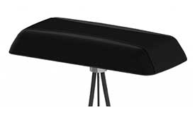
Tallysman debuted its VSP600L VeroStar precision antenna at Intergeo 2019, which took place Sept. 17-19 in Stuttgart, Germany.
Category: Receivers
-
Delving into a jungle mystery

Image: PrecisionHawk Earlier this year, a drone pilot and two data scientists from PrecisionHawk traveled to the Philippines for a unique mission — to fly drones equipped with lidar sensors over a dense rainforest to map ancient trade paths. The aim was to find buried treasure left by the Japanese during World War II.
PrecisionHawk was approached by the producers of a new History Channel show to help them navigate the Filipino rainforests. Through the combination of air and ground sensors, including a DJI M600 UAV equipped with a Riegl miniVUX lidar sensor and a Sony a6000 camera, PrecisionHawk staff produced a colorized 3D map of the forest.
The History Channel aired the series premiere of “Lost Gold of World War II” on March 19, 2019; all eight episodes are now available for streaming. The second episode features visuals generated by PrecisionHawk, as well as interviews with the drone pilot and data scientists.

Photo: PrecisionHawk -
Drones and imagery: Utilities turn to artificial intelligence
How AI and machine learning algorithms redefine the way utility companies manage their infrastructure
By Jaro Uljanovs, Lead AI Developer and Data Scientist, Sharper Shape
Artificial intelligence (AI) boasts a wide range of potential applications, across nearly every industry imaginable — healthcare, automotive, retail, even fast food. But it’s the utility industry where AI and machine learning (ML) are beginning to demonstrate some of their most impactful effects on many aspects of the business. Power companies are increasingly leaning on AI to improve their electricity delivery and prevent potential wildfires, and AI is actually enhancing, rather than eliminating, human jobs.
From data collection and analysis to their presentation of actionable insights, AI and ML algorithms are quickly redefining how utility companies manage their electric infrastructure.
Consolidating and classifying data
Utility companies oversee massive infrastructure networks, comprising poles, conductors, substations and transmission and distribution lines that span thousands of miles. The vegetation surrounding this key infrastructure must also be monitored, as it presents a danger of fire or outage.
Taking a comprehensive snapshot of these assets means utilizing a variety of different sensors for network inspections. These sensors include lidar, color (RGB), hyperspectral and thermal imagery.
This allows the system to capture everything — from vegetation proximity, to infrastructure assets, to individual components (such as insulators on poles) and their operational integrity, to hot spots indicating potential fire risks.
That’s a lot of data to capture, catalog and process. And there are a lot of individual elements within that data — even in just one image — to pinpoint and classify, let alone do so accurately. Classifying billions of data points across all of those images is an impossibly time-consuming task to do manually.

Photo: shaunl/E+/Getty Images AI and ML tools can accomplish that same work — scanning thousands of images collected across thousands of miles of utility infrastructure — in seconds. Lidar point cloud segmentation can detect conductors (quite a difficult component-type to segment) with an accuracy of over 90%, while hyperspectral image segmentation can identify vegetation species with an accuracy of up to 99%.
More than that, when paired with drone sensors, these algorithms can also improve the upfront collection of images and data. AI and ML tools help to adjust sensor positioning in real time, in the event a signal is lost or the drone veers slightly away from its inspection flight path.
By helping to readjust the sensors’ bearings while in flight, AI not only ensures more accurate data collection, but also that the flight doesn’t need to be done again or prematurely ended because of faulty data collection, saving time and money. AI pinpoints any faults in the sensors or the drone’s flight path while in the air, recalibrating as needed and identifying individual elements within the data as it comes through the sensor’s video feed.
Breaking down silos to create a holistic data approach
Key to all of this is eliminating the silos that tend to naturally build up between different data segments. In the utility inspection space, asset management, vegetation management, different sensors and so on all produce their own disparate, walled-off sets of data.
When data is kept siloed like this, it becomes unnecessarily difficult if not impossible for teams to derive companywide insights or conclusions from the information being collected. And what good is all that data if it can’t be used to check against itself and enhance other sets of data?

The northwest fire line of the wildfire that devastated Santa Rosa, California, taken by satellite Oct. 10. (Satellite image ©2017 DigitalGlobe) Good data management can’t exist in a piecemeal approach. It needs to be holistic, and AI provides the impetus to make that happen. AI provides a central resource for pooling all these data sources together, making it easier to cross-analyze for potential problems — like wildfire-prone vegetation or damaged components. When these issues are collected in one system, it becomes much easier to identify faults and resolve them — and do so far faster than it would be to manually sift through countless images of poles or vegetation maps.
And for all the stereotypical concerns about AI eliminating work for human beings, at utility companies AI actually enhances the role that people have to play in the network inspection process. Because the AI is what analyzes the data, it’s not something that is dependent on the potentially biased expertise of a professional human inspector, nor is it prone to fatigue and the anomalous results that can come from that. But at the same time, AI can’t do everything itself. It’s a tool for presenting clearer, more accurate and more actionable information for the people to then act on with their own judgment.
There’s a lot of easy-to-make assumptions, both good and bad, about AI. But at the end of the day, what AI really means for the utility industry is a more efficient and effective tool for providing the right information about a power company’s infrastructure — its transmission and distributions lines, its poles, and its nearby vegetation — into the hands of its key decision makers.
-
Pointfuse laser scanning software transforms digital construction workflows

A design mesh. (Photo: Pointfuse) Pointfuse has released the latest version of its advanced point cloud processing software that converts the millions of individual measurements captured by laser scanning and photogrammetry.
Featuring new streamlined classification to ensure maximum efficiency and multicore processing for unlimited conversion power, the new version of Pointfuse is set to transform workflows within digital construction, facilities management and virtual design applications.
“Pointfuse is designed to make the use of point cloud data more accessible by removing many of the traditional barriers to use,” said Mark Senior, regional sales director at Pointfuse. “Obstacles such as processing time and computer power, incompatibility within existing workflows and outputs files that are large and complex; these have all been obliterated with the latest Pointfuse release.”
Pointfuse now includes a new streamlined workflow which makes object classification easy, using templates and shortcuts to ensure maximum efficiency. This ability to classify objects within Pointfuse has had a huge impact on how as-built data is utilized within digital design workflows; being able to quickly compare specific as-built objects with the design enables more accurate clash detection, reducing the number of false clashes being flagged.
IFC (Industry Foundation Classes — an open format data model that is intended to describe architectural, building and construction industry data) templates can also be created and edited for specific applications. With applications including architectural, MEP and HVAC, selected objects can be classified and mapped to ensure compatibility with onward workflows.
Pointfuse also includes a new conversion engine which uses multicore processing to manage and enable unlimited point cloud conversion to provide real scalability. In addition, Pointfuse’s mesh models are intelligently optimized, reducing the working data size by a factor of up to 100, making them easy to share with online 3D collaboration platforms, such as BIM 360, 3D Repo, Revitzo and Trimble Connect.
“Using Pointfuse we can create intelligent 3D mesh models in a fraction of the time,” commented Ben Callan, BIM coordinator in global construction services company ISG’s UK Fit Out business. “This accelerated modelling and reduced risk of error contributes to a direct reduction in costs when compared against traditional methods of modelling and point cloud data analysis. The easy to use, easy to consume outputs are also paving the way for new applications of the data including existing versus design clash avoidance and checks of temporary works against required construction activities.”
-
Tersus GNSS launches Oscar GNSS receiver at Intergeo 2019
Tersus GNSS President and CEO Xiaohua Wen gives GPS World an overview of the company’s Oscar GNSS receiver at Intergeo 2019 in Stuttgart, Germany. According to the company, the Oscar GNSS receiver offers calibration-free tilt compensation that is immune to magnetic disturbances.
-
Viametris launches new version of urban and road scanner

Photo: Viametris Viametris has launched the second-generation version of the vMS3D, its urban and road lidar scanner.
The second-generation version of the 3D mobile vehicle scanner has been redesigned to be more compact. The system has been simplified considerably in both electronic and ergonomic terms to make it more robust and stable in adverse conditions and challenging environments.
Despite being lighter, the second generation offers the same technological capacities as its predecessor, but is simpler to use and can be mounted on a vehicle in minutes.
The system component (including the sensors) and the element to affix the device to the vehicle (the frame) previously formed one unit, but are now separated.
- The redesigned system is much lighter (9 kg) and more compact.
- The mechanism to fix the scanner to the vehicle, which formed part of the system in the first-generation version, has been transformed. A rigid metal frame, fixed onto two roof bars, now holds the system, which fits into a dedicated compartment in seconds. As the frame is rigid, it limits vibrations between the system and the vehicle and prevents any strain on the mechanics during acquisition.
- The second auxiliary antenna, which measures the heading by satellite, is discreet and non-removable, and fixed directly to the vehicle chassis.
The new design makes it easier to mount and use the system, a task that can be accomplished by a single person in under three minutes. Alignment takes place the first time the system is mounted and does not need to be repeated, saving valuable time each start.
Technological features
The vMS3D comprises a new set of components that are more robust and stable in difficult conditions.
- The integrated connectors are next-generation and embedded-grade.
- The control box for power supply and communication with the tablet has been moved inside the vehicle to offer increased comfort to the user.
Specifications
Receiver: Septentrio AsteRx-m2a GPS+GLONASS+BeiDou+Galileo, 448 channels – L1/L2, B1/B2, E1/E5B, RAW
IMU: SBG-Systems Ellipse2-D
Scanner: 700,000 points per second
Centimeter precision
Panoramic 30MP FLIR Ladybug 5+ camera
Double antenna
SLAM compatible
-

NovAtel defense manager joins anti-jam webinar panel

Dean Kemp Dean Kemp, defense segment manager for NovAtel, has joined the speakers’ panel for the June 27 complimentary webinar, Advanced Simulation Test Systems for Controlled Reception Pattern Antennas. He will present unique content alongside Lisa Perdue, simulation product manager for Orolia, and Stéphane Hamel, director of testing at Orolia.
Kemp has over 20 years of academic, industrial and business experience in engineering products and services. He spent a significant part of his career involved in antenna design and development, including controlled reception pattern antennas (CRPAs) for GPS anti-jam systems. As Defense Segment Manager, he is committed to precise, assured positioning and timing to address the needs of Navigation Warfare (NAVWAR) professionals and is dedicated to delivering high-quality products into the defense markets.
He holds a Ph.D. in antennas, radiowave propagation and computational electromagnetics from the University of Liverpool and an MBA from the University of Warwick. Prior to joining NovAtel, he worked at API Technologies, Cobham and Cobham Technical Services. His key technical skills include antenna/RF/microwave engineering, software development (Matlab, Fortran, VBA, Python), data analysis and processing, and test and measurement.
CRPAs are advanced, multi-element antenna solutions designed to protect a GNSS/GPS receiver from jamming sources. When combined with antenna electronics, they form an anti-jam antenna system (AJAS). These systems utilize several available technologies and vary in the number of elements.
This webinar will cover the basics of AJAS and CRPA, and the methods used to test them. Details on simulation system configurations, calibration techniques, and use case examples will also be presented. The webinar is sponsored by Orolia, a global provider of GPS/GNSS and resilient PNT solutions to support military and commercial applications.
-

U.S. Army to equip light armored vehicles with new GPS anti-jam units
The U.S. Army will send prototype anti-jamming systems to its 2nd Cavalry Regiment, stationed in Europe, in September to aid forces under GPS jamming or spoofing conditions. The first generation of Mounted Assured PNT Systems (MAPS) and anti-jam antennas are nearly ready for integration aboard armored Stryker vehicles, and the Army is already evaluating proposals for an upgraded version incorporating an inertial navigation system (INS) for further resilience.
The shipment comes in response to widespread Russian jamming of GPS signals from the sub-Arctic to the Middle East, and in tacit, likely tardy acknowledgment of Russian superiority in electronic warfare.
An Interim Armored Vehicle “Stryker” and AH-64 Apache helicopters with Battle Group Poland move to secure an area during a lethality demonstration as part of Saber Strike 18 in June 2018. (Photo: U.S. Army/Spc. Hubert D. Delany III, 22nd Mobile Public Affairs Detachment) Col. Nickolas Kioutas, Army project manager for positioning, navigation and timing (PNT), announced the move at the annual C4ISRnet conference in Arlington, Virginia. C4ISR stands for Command, Control, Communications, Computer, Intelligence, Surveillance, and Reconnaissance, or more broadly, electronic and other systems, procedures and techniques used to collect and disseminate information.
Three vendors are providing prototypes for the IMU-equipped second-generation MAPS, or MAPS-2, with testing to begin in September. A MAPS-3 capability, drawing on lessons learned in 1 and 2, may get underway soon. GPS Source, now a subsidiary of General Dynamics Mission Systems, made MAPS-1 and is now competing for MAPS-2.
The initiative reflects a new approach by the Army of “doing much smaller, iterative programs,” according to Col Kioutas. Traditionally, U.S. armed forces have taken years (and sometimes more years) to develop large, complex weaponry and supporting systems, and then even longer to deploy them. By the time they arrive in the operational theater, they are obsolete.
Rapid deployment of smaller, quickly designed and manufactured batches creates the opportunity for rapid feedback on what works and what doesn’t, with equally rapid return to the design board and re-manufacture. In other words, “shoot, aim, ready.”
Kioutas and crew are also flouting another U.S. military tenet, that in which previously “[we] asked for exactly what we wanted and industry built exactly to that. We don’t know exactly what we want. Tell us how we should do this the best, and then we’ll test that.” The PNT program has left requirements broad and open to change, knowing how quickly technology develops — and is shown to be vulnerable.
The Stryker is an eight-wheeled armored fighting vehicle, basically a lightly armored tank or heavily-armored troop carrier that is more road-friendly, that is, faster, than a tank. It has several variants of armament, armor and troop-carrying capacity. It saw extensive use in the Iraq counter-insurgency campaign.
-
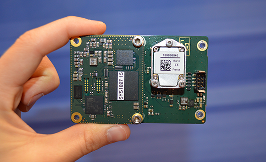
SBG Systems debuts line of inertial navigation systems at Xponential 2019
SBG Systems debuted its Quanta UAV series, a new line of inertial navigation systems (INS), at Xponential 2019, which took place April 29-May 2 in Chicago.
According to the company, the Quanta UAV is a small, lightweight and low-power INS. Designed specifically for UAV survey applications, the Quanta UAV series provides precise orientation and centimeter-level positioning data delivered both in real-time and post-processing.
“The Quanta UAV series is a new product line specifically designed for UAV applications and, more particularly, to precision applications like lidar mapping and photogrammetry,” Alexis Guinamard, chief technology officer at SBG Systems, told GPS World.
The Quanta UAV series is also offered on two levels of accuracy: one of its most important benefits, Guinamard added.
“The main advantage of the Quanta UAV series is high flexibility because we have two difference performance levels: the standard grade, which is suitable for most applications, and for higher altitude surveys we have Quanta Extra, which delivers improved accuracy,” Guinamard said.
According to SBG Systems, Quanta UAV embeds a web interface for an easy configuration with a 3D view showing all parameters. Its calibration tool automatically aligns the lever arm between the two antennas and the sensor, then re-estimates it in flight for more precision. The Quanta UAV also eliminates the need for ground control points.
In addition, the product comes bundled with one year of access to Qinertia, SBG Systems’ post-processing software, which will “enable accurate data in post processing,” Guinamard said.
The single- or dual-antenna also adds another layer of flexibility to the Quanta UAV series. According to SBG Systems, the dual-antenna mode allows a more precision heading, which is an ideal set up for low dynamic flights.
“I think the flexibility is the key advantage because we have these two performance levels and also the possibility to operate in real-time or in post-processing, and the possibility to operate in single- or dual-antenna,” Guinamard said. “It’s an all-in-one product.”
-
Tallysman launches helical antennas at Xponential 2019
Tallysman’s Allen Crawford offers an overview of the company’s recently launched helical antennas, which include the HC871, HC872 and HC600, at Xponential 2019, which took place April 29-May 2 in Chicago.
-
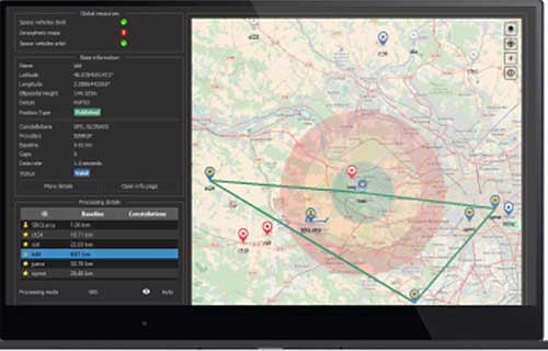
SBG’s Horizon IMU equips for harsh-environment hydrography
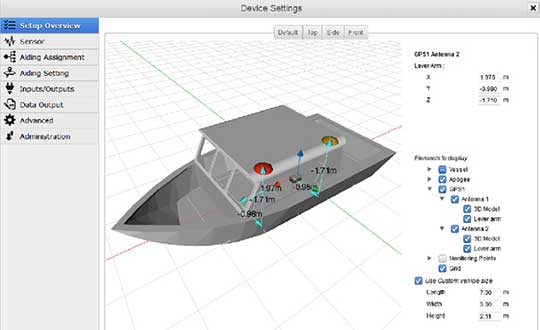
The Horizon fiberoptic gyro (FOG) inertial measurement unit (IMU) now forms part of SBG Systems’ Navsight Marine Solution, dedicated to hydrographers. Navsight is available at different levels of accuracy to meet the various application requirements and can be connected to various external equipment such as echo-sounders, lidar, and so on.
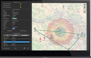
Photo: SBG Systems Navsight Marine Solution already offered two levels of performance with the Ekinox and Apogee IMUs. These MEMS-based IMUs address most of hydrographics markets whether shallow or deep water.
The new Horizon IMU enables customers to deploy Navsight in the most demanding environments such as surveying highly dense areas (bridges, buildings, and so on) as well as applications where only a single antenna can be used.
The Horizon IMU is based on a closed-loop FOG technology which enables ultra-low bias and noise levels. This technology allows robust and consistent performance even in low dynamics survey.
Navsight solution is easy to install, as the sensor alignment and lever arms are automatically estimated and validated. Once connected to the Navsight processing unit, the web interface guides the user to configure the solution. A 3D view of the vessel shows the entered parameters so that the user can check the installation. The Navsight unit also integrates light emitting diode (LED) indicators for satellite availability, RTK corrections, and power. It comes with a rugged enclosure, or in a rack version for larger vessels.
Completing the Navsight offer, Qinertia, SBG’s post-processing software, gives access to offline RTK corrections from more than 7,000 base stations located in 164 countries. Trajectory and orientation are then greatly improved by processing inertial data and raw GNSS observables in forward and backward directions. Computation takes less than 3 minutes for a 6-hour log thanks to the Forward and Backward calculation processed at the same time.
-
Mobile Mark launches low-profile combination antenna
Photo: Mobile Mark Mobile Mark Antenna Solutions has introduced the LLPG304 Series, a low-profile combination antenna that covers LTE & FirstNet, UHF and GNSS. According to the company, this three-cable surface mount antenna is designed specifically for public safety applications.
The broadband communications element covers 694-4200 MHz, including bands for cellular, LTE, FirstNet, and 5G-ready applications such as Citizen Band Radio Services at 3.7 GHz, the company added. The antenna also offers 3 dBi peak gain from 694-960 MHz and 4 dBi peak gain from 1710-4200 MHz.
The UHF element on the LLPG304 Series antenna covers the 450-470 MHz band with 3 dBi gain, and the GNSS geolocation element covers both GPS and GLONASS (1575 & 1602 MHz). It measures 9×3.5×1.25 in.
“The LLPG304 represents a very significant breakthrough in antenna coverage for the public safety community,” said Michael Berry, president and CEO and Mobile Mark. “This low profile, compact antenna offers both FirstNet coverage and traditional UHF Land Mobile Radio coverage.”
The LLPG304 is designed to meet industrial and military shock and vibration standards, including IEEE1478, EN 61373, MIL-810G and TIA 329.2-C.