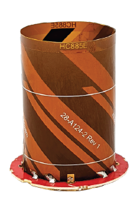
The HC885EXF embedded helical antenna. (Photo: Tallysman)
Tallysman Wireless has added the housed HC885XF and embedded HC885EXF dual-band eXtended Filtering (XF) antennas to its line of helical antennas.
The antennas receive GPS/QZSS L1/L5, GLONASS G1/G3, Galileo E1/ E5a/b, BeiDou B1/B2/B2a and L-band corrections services.
Historically, dual-frequency antennas and receivers commonly supported GPS L1 and L2 and GLONASS G1 and G2. In recent years, GPS, GLONASS, Galileo, BeiDou and NavIC have added GNSS signals in the L5 frequency band (1160-1217 MHz).
As a result, the new dual-frequency GNSS standard has become L1 and L5.
Tallysman’s new HC885XF antenna has been tuned to provide optimal support for the entire L1/G1/E1/B1/L-band correction and L5/G3/E5/B2 bands.
The radio frequency spectrum has become congested worldwide as many new LTE bands have been activated, and their signals or harmonic frequencies can affect GNSS antennas and receivers. In North America, the planned Ligado service, which will broadcast in the frequency range of 1526 to 1536 MHz, can affect GNSS antennas that receive space-based L-band correction service signals (1539-1559 MHz). New LTE signals in Europe [Band 32 (1452-1496 MHz)] and Japan [Bands 11 and 21 (1476-1511 MHz)] have also affected GNSS signals. Tallyman’s XF models mitigate the effects of these new signals.
The Tallysman HC885XF housed helical antenna weighs ~42 g and is enclosed in a robust, military-grade IP67 plastic enclosure. The antenna base has an integrated SMA connector, a water-proofing O-ring, and three screw holes to enable secure attachment.
Tallysman’s embedded HC885EXF helical antenna weighs ~8 g. It is easily mounted with an optional embedded helical mounting ring, which traps the outer edge of the antenna circuit board to the host circuit board or any flat surface. An MCX connector is installed in the base of the antenna.
Tallysman HC885EXF and HC885XF antennas are suitable for a variety of applications, including lightweight unmanned autonomous vehicle navigation (land, sea, and air), land survey devices, automotive positioning, timing and other precise-positioning applications.
the former Loran-C transmission antenna at Værlandet, Norway. (Photo: UrsaNav)
By Alan Grant and Dana Goward
In my “First Fix” editorial in the January 2022 issue of this magazine, I listed 10 questions about eLoran I had received from a PNT expert in response to an article about eLoran I wrote for the November 2022 issue. I encouraged eLoran proponents to address these questions. Two well-known authorities, neither of whom have a financial interest in the technology, stepped forward to help. Below, again, are my 10 questions about eLoran and their answers.
Alan Grant is head of Research and Development for the General Lighthouse Authorities of the United Kingdom and Ireland (GLA). He is an expert in radionavigation systems and leads the team that established the U.K.’s eLoran system, which operated from 2007 to December 31, 2015 in support of maritime users.
Dana A. Goward is president of the Resilient Navigation and Timing Foundation and a retired U.S. Coast Guard Captain. He also served in the federal Senior Executive Service as the maritime navigation authority for the United States. He has decades of experience with navigation policy and leading government policy and programs.
— Matteo Luccio, Editor-in-Chief
Accuracy specifics. While my November article stated that eLoran would have a two-dimensional accuracy of “better than 20 meters, and in many cases, better than 10 meters,” is that RMS, 95%, or some other statistic?
AG: Like any radionavigation system, the achievable accuracy will depend on several aspects, including the user’s location with respect to the broadcast stations and how error sources are modelled. The GLA eLoran service, when in operation in 2015, provided positional accuracy in the order of 8-10m (95%) to seven ports on the east coast of the UK. These ports had local reference stations to help manage temporal errors and the ports had been mapped to correct for additional secondary factors (ASF).i
DG: Others have reported greater accuracies using differential corrections.
Performance standard. GPS provides a commitment to users in a published performance standard. What specific measures of positioning accuracy, integrity and continuity would you recommend the proposed eLoran system be committed to provide (using the architecture described in the answer to Question 6)?
AG: The target performance would need to be tied to the target use cases to ensure the appropriate requirements are met. IALA provides guidance in this area for maritime services with general maritime requirements provided by the IMO within resolutions A.1046 and A.915.
Coverage. Would you recommend this eLoran positioning performance hold for the entire United States (including Alaska, Hawaii, Puerto Rico and other territories), only for the “lower 48” states, or only parts of these 48 states?
DG: The primary goal of any effort to complement and back up GPS/GNSS would be to make the nation and its citizens safer in at least two ways. First, to provide an alternative PNT source or sources in the event that signals from space were not available for any reason. Second to make GPS satellites and signals (and therefore the nation) safer by “taking the bullseye off GPS.” Having one or more alternatives will greatly reduce incentives for malicious disruption. To achieve these two goals the alternatives must be widely available and easily accessed. How widely available and easily accessed the United States or any other country wants to make such systems is a policy decision.
Current users. By number of users, the predominant common current civil uses of GNSS for positioning are consumer devices (mostly cellphones). By contribution to the U.S. economy, the predominant uses are high-precision applications. For what fraction of these uses would eLoran positioning be adequate? Could an eLoran receiver and antenna fit in today’s consumer devices?
DG: Lots of presumptions and assumptions in this question. Several overall thoughts, though. First, determining users’ real requirements can sometimes be difficult. I have a nice new full-size sedan. So, I think that is my requirement even though I could get to work almost as quickly and much less expensively if I owned a used compact car or caught the bus at the corner.
Second, GPS/GNSS will, hopefully, always be the primary source. The questions then are 1) how accurate can eLoran positioning become with additional work, and 2) how accurate does a fallback system need to be?
Durk van Willigen of Reelelektronika b.v. displays a combined GPS, GLONASS and eLoran receiver at the 2017 Munich Satellite Navigation Summit. (Photo: Reelelektronika)
Finally, as to equipment size, I recall seeing a photo of the first GPS receiver sitting on a pallet with two chairs for operators. Today, receivers are made at chip scale. Huge reductions in C-SWAP have been the growth arc for all kinds of technologies as they are implemented more and more widely.
In 2017 the Dutch company Reelektronika showcased a combination eLoran, Chayka, GNSS receiver that was only 6 cm long. This was achieved without a whole lot of investment in research and development. Who knows how low C-SWAP for eLoran receivers will go?
Future uses. Emerging civil uses of GPS for positioning include autonomous ground and air vehicles, navigation to space and in space, and lane-accurate car navigation. Which of these could be served by eLoran?
AG: The overall concept of having a mix of dissimilar position sources remains sensible for all modes. GNSS is expected to remain the primary means of position determination, with different use cases selecting different complementary systems based on their needs. eLoran may support some use cases but may not be the answer for all.
DG: Many believe GPS alone is not sufficient to serve some of the applications cited. This is the basis for language in both the European Radionavigation Plan and a U.S. Presidential Executive Order cautioning against over-reliance on GNSS. Perhaps GPS and eLoran together might be deemed sufficient. Or, perhaps a more diverse and resilient PNT architecture will give rise to additional applications such as precise positioning from 5G that will be sufficient.
Architecture. To maintain accuracy during a prolonged GPS outage, eLoran would require reference stations to calibrate time-varying propagation errors, as well as a certain number of transmitters for good nationwide geometry and for redundancy, ensuring service even if a transmitter is attacked or is taken off-line for maintenance. What architecture would you recommend to achieve this?
AG: The MarRINav projectconsidered a similar question for the UK and the project’s approach could be employed to consider this question for the United States.iv
DG: A good starting point for the United States might be the sites used by the shuttered Loran-C system. The federal government still retains custody of most of them. Also, considerable thought has been given to the questions of eLoran reference stations and integrity in the United States. PNT expert Mitch Narins, formerly of the FAA and now Strategic Synergies, advises that much of this work has been done. The FAA and Coast Guard conducted a study to deploy eLoran in the United States to support aviation non-precision approach, maritime harbor entrance and approach, and precise time and frequency users. The proposed architecture supported aviation’s demanding integrity requirement (1×10⁻⁷), maritime’s demanding accuracy requirement (8-20m), and time and frequency users’ precision requirements (100 ns/Stratum 1).
7. Infrastructure cost. What would be the cost of installing the required transmitters, power supplies, reference stations, communication links and control system for the architecture described in the answer to Question 6? Can you reference a recent and independent estimate? To a ballpark figure, what cost fixed-price contract would you accept to implement it? Similarly, what would be the annual costs for operating and maintaining this infrastructure?
AG: The MarRINav project produced a cost-benefit analysis report that addresses some of these questions, albeit aligned to the approach proposed for the UK. The documents are open source and available on the MarRINav website.
DG: To quote President Kennedy, “There are costs and risks to a program of action, but they are far less than the long-range risks and costs of comfortable inaction.”I agree with Dr. Grant that the capital costs in MarRINav are roughly transferrable to the United States. As another data point, the 2010 operating cost for Loran-C in the United States was about $36M/year. That number included several hundred employees, though. Plans to automate the system projected reducing annual costs to $15M/year in 2010 dollars.
Impact. eLoran transmitters are large and high-power. Providing positioning across the United States could require building some of them from scratch or significantly reconstructing old Loran sites. What issues — such as environmental, aviation safety and security — would this raise, and how would you recommend they be addressed?
DG: These issues would be dealt with the same way they are for any construction project. eLoran transmission sites are essentially the same as commercial AM radio stations. Reusing sites still owned by the government could make the process even easier. Compared to the cost and difficulty of putting PNT assets in orbit, these challenges should be relatively easy to overcome.
Receivers. Assuming all the above were achieved, it would accomplish nothing unless eLoran receivers were widely purchased, installed and used. How much would that cost? Who would pay? Should we assume that “if we build it, they will come”?
AG: This is a valid concern and has different answers depending on the planned use case and the level of national/international standardization required. Within the maritime sector, the IMO has approved a multi-system receiver performance standard that supports the use of all GNSS and terrestrial systems within one device, rather than having a separate eLoran receiver.
DG: I completely agree — adoption and use are absolutely key. Fortunately, government leaders have a wide variety of levers to influence adoption and use. These range from education and encouragement to regulation, legislation, and subsidies.
Alternatives. Given the widespread development of other positioning technologies over the past decade, much has changed since the earlier recommendations for eLoran. How do we know that eLoran is the right investment — or even a needed part of the solution or needed system in a system of systems — for the future of U.S. PNT?
AG: The MarRINav project researched and compiled details of different positioning, navigation and timing technologies supporting maritime navigation, within Deliverable D4. The recommended system-of-systems approach recognized that there was no one-fit-all solution, rather it sought to allow for a scalable solution that reflects users moving from location to location and between systems. It considered global, regional and local solutions, recognizing the cost vs. usable coverage tradeoff for each. The proposed solution of GNSS, supported by eLoran in combination with VDES R-Mode and radar absolute positioning, was deemed as the most appropriate mix for the UK, given geographical and political constraints. The approach can be ported to investigate the appropriate options for the United States.
DG: The U.S. Department of Transportation’s January 2021 report to Congress has findings similar to those in MarRINav. It described a system of systems that included fiber, satellites and terrestrial broadcast. The department subsequently said that a critical factor for a terrestrial broadcast system would be the coverage area per unit of required infrastructure. Of the systems discussed, eLoran met this criterion best. This recent finding is consistent with numerous other government reports, two previous government announcements that it would build eLoran, two recommendations from the President’s National Space-based Positioning, Navigation, and Timing Advisory Board and the technology’s on-going use around the world. Likely someday there will be something to replace GPS and other legacy technologies. We must work with the combination of technologies we have now until that day arrives.
Common Threats
Common threats to GNSS and eLoran could include the following:
1. Cyber attacks. Given that GPS’s OCX is said to be the most cybersecure system built by the U.S. Department of Defense, how would eLoran’s control system be even more cybersecure than OCX, to avoid a common cyber-vulnerability?
AG: Cybersecurity is a key concern and one that any navigation and safety of life system must consider. I will leave manufacturers of each system to comment on how secure they are. However, if we consider signal interference and data manipulation within this category, then using a stronger signal at a different frequency to GNSS provides some protection against jamming. While any radio signal can be jammed, the perpetrator would need more power and physically larger equipment to jam at lower frequencies.
DG: Yes, the security of control systems is very important and must be included in the design up front. Authentication and security of signals, and the cybersecurity of receivers must be as well. This is especially true for complementary systems for GPS since GPS signals are so open and vulnerable, and so many receivers are largely unprotected. We will have the opportunity to do better with a new system and avoid the huge expenses of OCX, the new GPS control system.
Additionally, let us not forget that cybersecurity is needed for much more than control systems. Signals and receivers need to be much more secure than civil GPS is right now. A new system, be it eLoran or another technology, will be able to build cybersecurity in from the beginning.
Physical attacks. Given concerns about possible physical attacks on GPS satellites, which move at multiple km/sec 20,000 km from Earth, would it not be easier to physically attack eLoran transmitters, which are stationary, terrestrial, in remote locations, and hundreds of feet tall and require massive power sources?
AG: We should not lose sight that any ground infrastructure can be attacked, regardless of whether it is a satellite uplink station or part of a terrestrial communications or positioning system. Careful selection of the transmitter location, along with suitable site security options should help deter the attack and mitigate the impact where possible.
DG: Every physical asset and every signal is vulnerable to some degree to attack by a host of malicious actors, and damage by a variety of natural occurrences. The key to resilience and making PNT sources less attractive targets is to have diverse sources with the smallest number of common failure modes.
Space weather. GPS is potentially vulnerable to severe space weather that could damage satellites or temporarily hinder signal propagation from space to Earth. However, severe space weather could also damage the power grid upon which megawatt eLoran transmitters rely. How would eLoran service be protected from the effects of severe space weather, such as a Carrington Event?
AG: Space weather has the potential to affect all radio broadcasts. Depending on the type of event it can affect performance several different ways, including ionospheric scintillation, applying forces to satellites or disrupting power networks. The aim is to use systems where the underlying failure modes are as different as possible. Using a combination of satellite and terrestrial signals, at different frequencies, with local power generation where possible can help mitigate the impact. Whether it’s possible to mitigate all the implications of a Carrington type event is not clear and perhaps one for the experts.
DG: With the available warnings about solar events, it is conceivable that both GNSS and terrestrial systems could be powered off or otherwise secured for such an event to minimize damage. A new-build terrestrial system could also be constructed with surviving a Carrington Event in mind. And, of course, terrestrial systems will be easier to access, repair, and replace than those in space. As for other possible issues with the power grid, generators, uninterruptable power supplies, and other backup methods can easily be installed. Before 2010, several U.S. Loran-C transmitters were in such remote locations, they never had grid power and were always powered by generators.
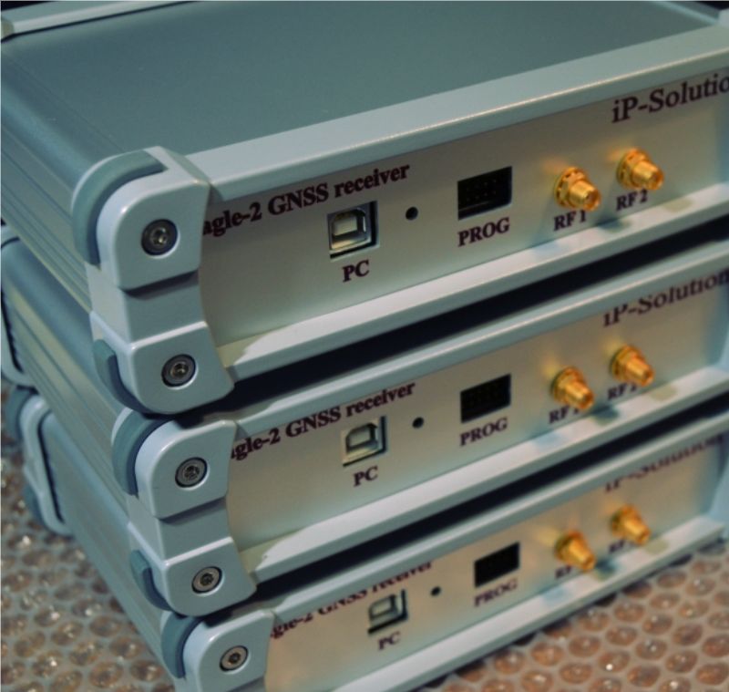
iP-Solutions has added a GNSS receiver to its software-defined-receiver (SDR) front-end family. The new Eagle-2 works with software receivers in real time or records GNSS signals for post-processing.
For post-processing, Eagle-2 it supports most third-party receivers, such as MATLAB and C/C++ receivers.
The front end allows a user to work with two perfectly synchronized channels connected to two antennas.
The Eagle-2 supports GPS, Galileo, GLONASS , BeiDou, QZSS and SBAS.
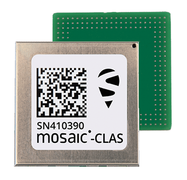
Septentrio, a leader in high-precision GNSS positioning solutions, has launched three new products that support Japan’s high-accuracy Centimeter Level Augmentation Service (CLAS).
The three multi-frequency GNSS receivers support CLAS on a single device, thanks to the latest GNSS technology which receives the L6 signal, which transmits high-accuracy corrections from Japan’s QZSS constellation. This technology was developed in close cooperation with CORE, a leading integrator of high-accuracy positioning technology and services in Japan.
The mosaic-CLAS receiver is a GNSS module with a very small form-factor suitable for high-volume industrial applications.
The AsteRx-m3 CLAS is Septentrio’s best-in-class OEM board combining PPP-RTK CLAS with dual-antenna heading functionality.
The AsteRx SB3 CLAS features a ruggedized IP68 enclosure to protect it in harsh environments.
Septentrio is simultaneously offering various receiver types to the Japanese market ensuring an optimal match between products and customer needs in various applications including robotics, precision agriculture, construction, machine control and UAV.
“We are very pleased to jointly develop CLAS software on a new GNSS module, mosaic-CLAS,” emphasized Takahiro Yamamoto, director, GNSS Solution Business Center at CORE Corp. “This receiver puts CLAS GNSS technology on par with regular RTK receivers in terms of size as well as price. We believe that the realization of CLAS on the Septentrio mosaic platform will significantly promote the use of new QZSS services for industrial applications.”
“The launch of our new module and OEM board with CLAS support opens up new markets and use cases, which will benefit from centimeter-level positioning with fast acquisition time,” commented François Freulon, head of Product Management at Septentrio. “This launch demonstrates the technological leadership of Septentrio and our ability to provide dedicated solutions embedding L6 bands for the Japanese market.”
The CLAS PPP-RTK is the latest generation of GNSS correction services, combining near-RTK accuracy and quick initialization times with the broadcast nature of PPP. Receivers with built-in CLAS functionality offer sub-decimeter positioning accuracy right out of the box. Corrections for high-accuracy positioning are received directly from satellites, reducing the need for additional base stations or service subscriptions.
Find out more about PPP-RTK and other positioning correction methods in the insight article GNSS Correction Demystified.
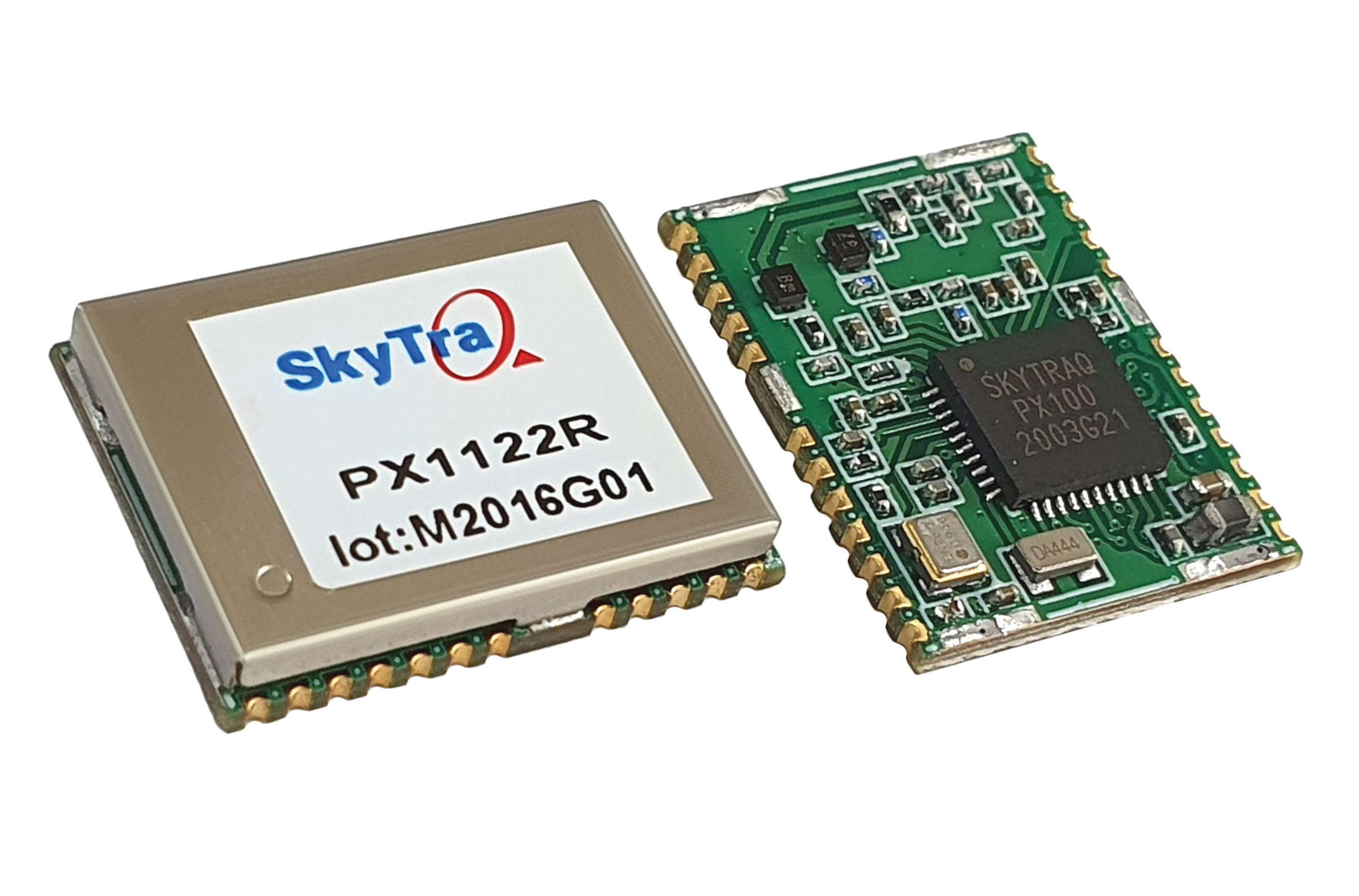
SkyTraq Technology, a fabless semiconductor company, develops GPS/GNSS chipsets and modules for meter-level accuracy vehicle navigation and tracking applications and for centimeter-level accuracy real-time kinematic (RTK) surveying and precision guidance applications.
Photo: SkyTraq
The company’s chipset design is driven by market trends, said Oliver Huang, the company’s general manager. He explained the company has moved from single-frequency to dual-frequency devices.
SkyTraq’s chipset is designed to be common hardware for different target applications enabled by customized software. Traditionally, in the automotive market, vehicle navigation systems have relied on fusing GNSS receivers with dead-reckoning technology that uses micro-electromechanical (MEMS) inertial measurement units (IMUs) and wheel-tick data.
“We are now seeing more aftermarket vehicle tracking applications that take advantage of superior GNSS/DR performance using untethered dead-reckoning technology that uses sensor fusion of GNSS receiver and MEMS IMUs without the need for wheel-tick data,” Huang said. “GNSS receivers with decimeter or better accuracy, combined with dead-reckoning that uses low drift IMUs, will be important in emerging autonomous vehicle applications.”
SkyTraq’s PX100 chipset for L1 meter-level accuracy applications and centimeter-level accuracy RTK applications uses L1 and L1/L2 signals from all four major GNSS constellations (GPS, GLONASS, Galileo and BeiDou).
Because of the trend toward high-precision, which requires good carrier-phase raw measurement data, the biggest challenge in receiver design is with the antenna, Huang explained. “Using an advanced semiconductor process, one can have low power, small size chipsets taking advantage of all the available GNSS signals, yet there is no small antenna capable of producing high-quality carrier phase data for high-precision GNSS applications. So far, we have only seen bulky RTK antennas capable of generating high-precision results.”
Editor’s Note: This video was originally published on November 12, 2019.
Orolia debuted the GSG-8 advanced GNSS/GPS simulator, which is powered by Skydel simulation engine, at ION GNSS+ 2019 in Miami. Watch the video to get an overview of the GSG-8, which the company says was designed to deliver the highest standard of GNSS signal testing and sensor simulation performance in an easy-to-use platform.
2J Antennas has introduced the Stellar series, antennas designed for a large suite of devices with a focus on GNSS, sub-6 GHz, 5G NR, 4G LTE, 3G, 2G and WiFi-6E technologies.
The Stellar Series is suitable for law enforcement, medical transportation, fire rescue and other applications where mission-critical communication is a requirement. The antennas are designed to reliably provide real-time connectivity in a small size.
This series includes single or up to 9-in-1 configuration choices within the range of 617 MHz to 7125 MHz frequency bands.
The patent-pending technology reduces the antenna footprint by 55% while implementing a new double trifilar design and longitudinal resonances for MIMO/ARRAY configurations that traditionally have more complex size restrictions (such as B71 band/600 MHz).
Each antenna configuration uses symmetrical or asymmetrical resonators for negative sections of the antenna, resulting in maximum performance at low and mid frequencies. The Stellar series offers magnetic and adhesive mounting choices, making them suitable for temporary installations.
For permanent installation, 2J Antennas also offers the screw mount option in its roof series. The low-profile and lightweight housing introduces a new design that offers a more cost-effective solution for suppliers and distributors.
“We are excited to reinvent antenna designs to meet the fast-growing global markets and offer antenna solutions with the highest quality while reducing antenna sizes as much as possible,” said Ruben Cuadras, director of engineering. “We are proud to continue to bring antenna solutions to customers that require small device integration, reliability and new designs.”
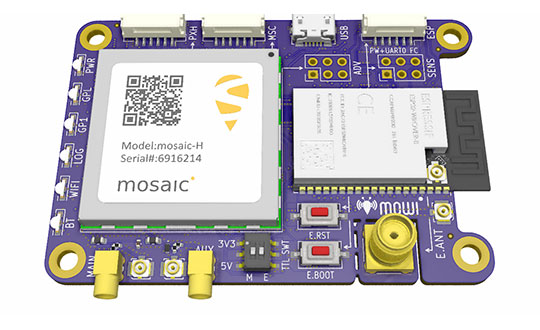
Mowi is an open-source reference design for Septentrio’s highly accurate GNSS module mosaic. It offers Wi-Fi and Bluetooth communication, which can easily be programmed for custom applications.
Septentrio, a manufacturer of high-precision GNSS positioning solutions, has added to its open-source resources for GPS/GNSS module receivers with mosaic wireless, which it calls mowi.
Mowi combines the Septentrio mosaic-X5 or mosaic-H module receiver with a dual-mode Bluetooth and integrated Wi-Fi from the well-known ESP32-WROVER programmable module by Espressif Systems. It is an addition to the already existing mosaicHAT board, designed on the Raspberry Pi platform.
“We are excited about the mowi project being part of the GitHub and prototyping community,” said Gustavo Lopez, market access manager at Septentrio. “The project is available as open-source, thus empowering the community to easily fit autonomous or robotic systems with communication and highly accurate and reliable GNSS positioning technology. Mowi empowers the native Ethernet features of the mosaic module, the perfect tool for fast prototyping and developing proof-of-concept projects in a simple and connected way.”
The mowi project facilitates accurate and reliable GNSS positioning for robotic and autonomous devices, on a hardware level. Numerous engineers today use the ESP32 and the multiple libraries available for internet-of-things (IoT) prototyping. The mowi board is an easy way for integrators to get started with Septentrio’s mosaic-X5 or mosaic-H heading module receivers.
The mowi board can be used on its own or plugged into a mobile computer such as Raspberry Pi or Arduino to deliver high-accuracy positioning with high update rates, suitable for machine navigation, monitoring or control. The internet connection via Wi-Fi or Bluetooth enables numerous industrial IoT applications, simplifying the connectivity to mobile data for the delivery of GNSS corrections needed for centimeter-level RTK positioning.
On top of the wireless communication, the 47.5 x 70 mm board can host IoT applications in its internal memory. It has onboard logging and exposes interfaces such as USB, serial communication and general-purpose pins. The schematic’s reference design, PCB layout and documentation are openly available for prototyping or further customization.
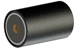
Maxtena has introduced a new multi-frequency antenna shaped for high-precision applications featuring L-band corrections.
Photo: Maxtena
The design will offer simultaneous GNSS reception on L1: GPS, GLONASS, Galileo, Beidou, L2: GPS L2C, Galileo E5B, and GLONASS L3OC, and L5: GPS + L-band corrections in a rugged, compact, and ultra-lightweight form factor. The antenna is well suited for high precision applications. The M9HCT-A-SMA is a great fit for the UAV markets, where high performance and low weight are driving features in antenna selection.
The new rugged active helix antenna is designed and manufactured using automotive grade electronics for GIS, RTK and other GNSS applications.
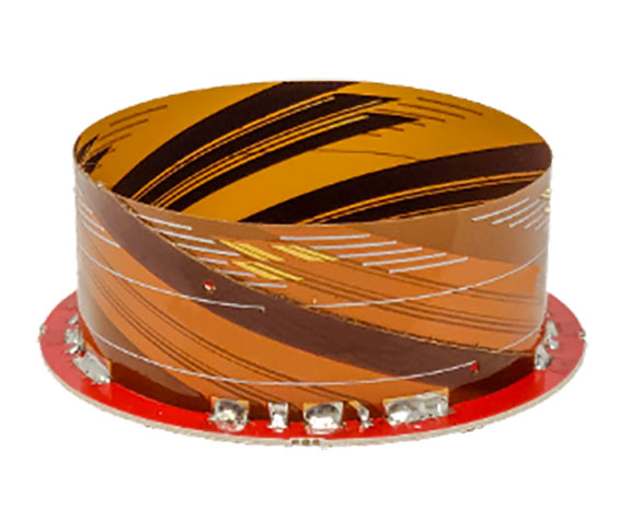
Tallysman Wireless Inc. has added its first full-band GNSS antenna to its line of helical antennas.
The full-band GNSS HC990E embedded helical antenna is designed for precise positioning, covering the GPS/QZSS-L1/L2/L5, QZSS-L6, GLONASS-G1/G2/G3, Galileo-E1/E5a/E5b/E6, BeiDou-B1/B2/B2a/B3, and NavIC-L5 frequency bands, including the satellite-based augmentation system (SBAS) available in the region of operation [WAAS (North America), EGNOS (Europe), MSAS (Japan), or GAGAN(India)], as well as L-band correction services.
The HC990E embedded helical antenna is designed and built for high-accuracy positioning. It is packaged in a very light and compact form factor, making it suitable for a wide variety of applications, especially lightweight unmanned aerial vehicle (UAV) navigation.
The HC990E is 60-mm wide and 25-mm tall, weighing 12 grams. It features a precision-tuned helical element that provides an excellent axial ratio and operates without the requirement of a ground plane. The HC990E also features a low-current, low-noise amplifier (LNA) and pre-filter to prevent harmonic interference from high-amplitude signals, such as 700 MHz band LTE and other nearby in-band cellular signals.
The HC990E antenna base has a flying lead with a UFL connector. To facilitate the installation, Tallysman provides an optional embedded helical mounting ring, which traps the outer edge of the antenna circuit board to the host circuit board or any flat surface. Tallysman also supports the installation and integration of embedded helical antennas to enable successful implementation and provide optimal antenna performance.
NV5 Geospatial has launched Trim Optimization, a predictive modeling platform that enables electric utilities to enhance vegetation management programs with risk-based assessments.
Using information from existing lidar and historical data, utilities can leverage Trim Optimization to prioritize tree-trimming activities by taking into account the risk posed by individual trees and other operational constraints.
“Trees are to blame for a large percentage of outages, and vegetation management is the single biggest cost for electric utilities. Yet, utilities have only started to look at proactive, risk-based management programs, rather than the traditional cycle-based ones,” said Ian Berdie, vice president of innovation for NV5 Geospatial. “NV5 Geospatial’s Trim Optimization platform will help utilities improve grid reliability through better decision making, while also saving them money through greater efficiency and the ability to target areas that have the most potential for problems.”
Vegetation is one of the largest sources of outages, accounting for more than half, according to a recent survey, “Geospatial Analytics, Resilience and Extreme Weather Readiness.” The majority of respondents also noted that they use data to analyze risk, but budget constraints often prevent them from investing in the data they need.
The trim optimization platform takes a phased approach to identify relative risk to target vegetation management work where it will have the most impact. With extensive expertise, NV5 Geospatial first identifies several attributes associated with vegetation-caused outages that can be modeled from high-density lidar and provide a relative risk score.
Utility-specific data, such as historic tree failures information or other factors, can be analyzed to enhance results further.
The final risk scores will provide a quantitative assessment of combined risk, enabling utilities to develop work plans that prioritize vegetation management mitigation efforts and result in greater operational efficiency.
NV5 is holding a webinar on Trim Optimization on Aug. 25. Register here.
Spirent Federal Systems, a provider of PNT/GNSS test equipment, announced plans to fully validate the inertial interface between Spirent GNSS simulators and both Northrop Grumman legacy and modernized inertial systems under the EGI‐M program.
For years, Spirent Federal has developed inertial interface test tools in collaboration with Northrop Grumman that yield repeatable, accurate results.
Northrop Grumman’s embedded GPS/inertial navigation system (INS)‐modernization, or EGI‐M, program is developing airborne navigation capabilities with a government‐owned open architecture. The fully modernized system integrates new M‐code capable GPS receivers, provides interoperability with civil controlled air space, and implements a new resilient time capability.
“Spirent Federal has long supported testing of the Northrop Grumman family of interfaces,” said Jeff Martin, Vice President of Sales for Spirent Federal, “and our customers have always obtained precise, reliable results. Spirent Federal strives to keep abreast of the newest technology to be ready to meet the needs of industry, and this collaborative effort that includes the EGI‐M program is yet another example. Spirent is an important part of Northrop Grumman’s test solutions and this validation project acknowledges that importance.”
Spirent Federal has been providing tools for testing inertial systems for more than two decades. Available SimINERTIAL interfaces comprise various EGIs and IMUs from manufacturers of inertial sensors, including Northrop Grumman (formerly Litton), Honeywell and Atlantic Inertial Systems, as well as standardized interfaces such as STANAG.
Testing the full operational performance of GPS/inertial systems usually requires expensive and time‐consuming field testing on a moving vehicle. Spirent’s SimINERTIAL system emulates inertial sensor outputs while concurrently simulating GPS RF signals, enabling controlled, repeatable testing of EGIs and reducing the need for field trials.