Antenova Ltd., manufacturer of antennas and RF antenna modules for M2M and the Internet of Things, has announced a new embedded GNSS antenna named Sinica, which operates on the 1559-1609 MHz satellite bands. The Sinica antenna uses a novel design approach and new materials to achieve high performance from an ultra low-profile antenna, Antenova said.
Sinica is suitable for all positioning applications on the 1559-1609 MHz bands. It operates with all of the public satellite constellations — GPS, GLONASS, Baidou and Gallileo — which means it can provide accurate positioning combined with global coverage.
The Sinica antenna is created from FR4 materials and new dielectric constant laminate substrates. It uses a new approach to antenna design, which has enabled the company to create an antenna with the high performance of a ceramic patch antenna, in a low profile part that can be placed neatly within a small printed circuit board, Antenova said.
Sinica is designed for devices that need accurate positioning or tracking globally, which means it is suitable to use in drones, network devices and wearable electronics, or any other portable device or tracking application.
Antenova’s product designers recently introduced the concept of “Design For Integration” (DFI), which considers how the antenna will operate when it is embedded with a manufacturer’s product. Antenova’s antennas are used within a customer’s design, so they are designed to provide superior RF performance from within the device, and to make the integration of the RF elements easier for the designer, the company said. In addition to this, Antenova provides its customers with technical support during the design, integration and testing phases.
Earlier this year, Antenova announced three new families of antennas for the fast growing M2M, wireless and IoT sectors. Sinica belongs to the lamiiANT family of new antennas for these market sectors.
The antennas are supplied on tape and reel and are available through distributors worldwide. Go to www.antenova-m2m.com for more details, or to request an evaluation board for the Sinica antenna.
LizardTech, a provider of software solutions for managing and distributing geospatial content, launched GeoExpress 9.5 at this week’s Esri International User Conference. The conference is taking place in San Diego, Calif., and LizardTech is exhibiting in booth number 2310.
GeoExpress enables geospatial professionals to compress and manipulate satellite and aerial imagery. In addition to compressing raster data, GeoExpress 9.5 now features the ability to natively compress LiDAR data to MrSID and LAZ formats, saving up to 75 percent on storage space.
GeoExpress 9.5 also includes batch color balancing, multipolygon cropping and exporting images to custom dimensions and tiles. Esri UC attendees can see demonstrations of the new features of GeoExpress 9.5 at booth 2310.
“The launch of GeoExpress 9.5 is particularly exciting because of the many benefits this latest version brings not only to our raster image collection customers, but also LiDAR data collection customers,” said Jeff Young, LizardTech global business development manager. “GeoExpress 9.5 is now your one-stop shop to compress raster and LiDAR imagery to MrSID and LAZ formats.”
LizardTech will also showcase the rest of the company’s line of geospatial products: Express Server software for high-performance delivery and publication; LiDAR Compressor software, which turns giant point cloud datasets into efficient MrSID files; and the recently updated GeoViewer software, which a fast way to view MrSID and JPEG 2000 imagery.
Avineon, Inc., a global provider of information technology and engineering support services, will be presenting its complete portfolio of geospatial offerings at the 2015 Esri User Conference in San Diego, Calif., on July 20-24. A long-time Esri Business Partner, Avineon develops and implements a wide variety of geospatial services.
Avineon will be making presentations and providing demonstrations in booth #1015.
Avineon offers geospatial products and services to Esri clients in numerous industries, including energy water, and communications utilities and all levels of local, state, and federal government agencies. Avineon specializes in assuring and enhancing the quality of existing data through extensive data conversion, migration, conflation, and enrichment services. In addition, the firm extracts new data sets, such as orthoimagery, digital elevation models (DTMs), and 3D visualizations from aerial photography and LiDAR acquisitions.
Avineon also provides support for version upgrades and cloud migration, software testing and help desk staffing. In the web/mobile arena, Avineon has a long history of creating custom applications and server extensions for outage management, field workforce management, wire down monitoring, and other efficiency-enhancing applications. When consolidating to a single system is not practical, Avineon implements cross-platform technologies that normalize spatial data and establish data governance programs across diverse GIS data sets.
“Avineon has been working closely with Esri for more than 10 years to create innovative solutions for GIS clients worldwide,” said Joel Campbell, Avineon’s vice president of commercial systems. “We invite all Esri Conference attendees to visit our booth and learn how Avineon can make your geospatial content more intelligent.”
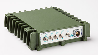
Public Works and Government Services Canada (PWGSC) has selected NovAtel’s GAJT-AE antenna electronics for testing on Canadian Army platforms. The GAJT-AE, developed in Calgary at NovAtel’s global headquarters, is a GPS anti-jam solution suitable for small and weight constrained applications. The testing is being conducted through PWGSC’s Build in Canada Innovation Program (BCIP).
PWGSC will procure a number of GAJT-AE’s on behalf of the Department of National Defence (DND). The Director Land Requirements (DLR), with the assistance of the Quality Engineering Test Establishment (QETE), will oversee all testing on DND’s behalf. Field testing is expected to take place in the latter half of 2015 at 4th Canadian Division Support Garrison Petawawa.
The testing will analyze the performance of GAJT-AE on Canadian Army equipment in operational conditions to confirm the suitability and robustness of the NovAtel technology for this role. The process is expected to be completed by the end of March 2016.
GAJT is a null-forming technology that negates jammers, ensuring the satellite signals necessary to compute position and time are always available. Three categories of GAJT are manufactured by NovAtel:
GAJT-710ML: for use with military land vehicles, networks and timing infrastructure
GAJT-710MS: for marine vessels, from small boats to capital ships
GAJT-AE: for use with an external antenna in size and weight constrained applications
“NovAtel has had great success working closely with the Canadian Army on the previous round of BCIP,” said Jason Hamilton, NovAtel’s vice president of marketing. “It is essential to have military users test our products in operational scenarios. We look forward to the valuable feedback that the Canadian Army testing of GAJT-AE GPS anti-jam antenna electronics will provide. NovAtel will use this feedback to continue developing products in support of Canada and its Allied partners.”
The BCIP was created by the Government of Canada to strengthen Canadian innovation. The program offers procurement and testing of pre-commercialized products and services, at a late stage of development. The BCIP:
Bridges the “pre-commercialization gap”
Supports Canadian suppliers by connecting innovators and government users and by testing innovations
Provides real-world evaluation of pre-commercial goods and services
Improves the efficiency and effectiveness of government operations.
The United States Geospatial Intelligence Foundation (USGIF) announced the six recipients of its 2015 Awards Program on the main stage at the GEOINT 2015 Symposium, being held this week in Washington, D.C. The USGIF Awards Program annually recognizes the exceptional work of the geospatial intelligence tradecraft’s brightest minds.
“Each year as the nominations come in, we are always amazed by the exceptional work of the individuals and teams from government, military, industry, and academia being submitted for consideration,” said Kevin Jackson, chair of the USGIF Awards Subcommittee. “The opportunity to review the dozens of nominations and to understand the significance of your accomplishments and the impact of your contributions to the community, our country, and the world — which most likely never make the news—is truly humbling. The 2015 USGIF Award winners represent a community that we should be very proud to be a part of.”
The 2015 USGIF Award winners are:
Military Achievement Award: Air Force/Director for Intelligence, Surveillance, and Reconnaissance Interoperability(AF/A2I), Surveillance Intelligence Reconnaissance Information System (SIRIS) Team
SIRIS is a government-owned, high-performance, web-based capability that enables open observation, lightweight visualization, and game-changing collaboration for dynamic mission planning and execution across multiple networks. SIRIS collaboration is conducted via a real-time, integrated display of correlated and fused data from National Reconnaissance Office joint collaboration cells, allowing tactical operators to create a tailored, user-defined operational picture. SIRIS reduces fratricide, protects noncombatants and increases combat capability, and saved valuable fire-fighting time during the California rim wildfire. SIRIS is managed by A2 Innovations Director James “Snake” Clark and was created by Chris McDonald and Tim Petronello.
Government Achievement Award: U.S. Army Geospatial Center
In late 2012, months of drought left water levels along a 180-mile stretch of the Mississippi River as much as 20 feet below normal, exposing rock pinnacles in the navigation channel and restricting barge traffic from St. Louis, Mo., to Cairo, Ill.—essentially halting commerce along the Mississippi River. The U.S. Army Corps of Engineers is charged with keeping the river safe and navigable, and in this case needed to provide frequent updates to the White House on the progress of removing the pinnacles to restore navigation. The majority of geospatial products, although very accurate, were too complex for executive-level briefings. In a short timeframe, a team of Army Geospatial Center personnel synthesized the information gathered by the Corps and created geospatial products that enabled the President to quickly understand the problem and how it was being remedied.
Industry Achievement Award: George “Guy” Thomas, C-SIGMA, LLC
George “Guy” Thomas is a former U.S. science and technology advisor for maritime domain awareness and father of space-based automated identification systems (AIS). He also founded the Collaboration in Space for International Global Maritime Awareness (C-SIGMA) organization. Space-based AIS is changing how the maritime world operates by adding global transparency to operations. C-SIGMA works to increase safety and security in the maritime domain as well as protect the maritime environment and resources worldwide. Thomas’ 40-year career in surveillance includes positions with the U.S. Navy, Air Force, and Coast Guard, as well as with industry and Johns Hopkins University’s Applied Physics Laboratory. He led the introduction of both the Navy’s EP-3E and the Air Force’s RC-135W—the first reconnaissance aircraft with mission-system computers.
USGIF CEO Keith Masback (right) presents Bosarge with the USGIF Academic Research Award.
Academic Research Award: George Stanley Bosarge, University of South Alabama
George “Stan” Bosarge is senior research laboratory manager for the Fisheries Ecology Lab of the Dauphin Island Sea Lab, as well as the benthic habitat assessment program manager for the University of South Alabama’s department of marine sciences. Bosarge’s research is centered on a large-scale and long-term fisheries assessment project called the Fisheries Independent Ecosystem Survey. It’s designed to assess post-oil spill red snapper population recovery and the spatial relationships of red snapper to artificial and natural reef habitat off coastal Alabama. In 2016, he will join the Northeastern University faculty to teach a class on free and open-source GIS desktop applications in the university’s geographic information technology program.
Academic Achievement Award: Professor Dorota A. Grejner-Brzezinska & Dr. Charles Toth, Ohio State University
In the past 15 years, professors Dorota Grejner-Brzezinska and Charles Toth of the Ohio State University have significantly influenced the future of geospatial intelligence by advancing state-of-the-art geospatial data acquisition and processing technologies. Their most significant achievements include pioneering work on high-accuracy, direct sensor georeferencing algorithms and methodology; developing state-of-the-art sensor error models; developing novel compression technology for LiDAR data; and introducing an innovative and automated waveform processing method to support better point cloud generation and land-cover classification. This is the second time the duo has received a USGIF award, the first being the 2005 Academic Research Award for research on a personal navigator relevant to national security.
Outstanding Administrative/Support Award: Donna L. Pelle, National Geospatial-Intelligence Agency
As the executive officer for the National Geospatial-Intelligence Agency Support Team (NST) to the National Air and Space Intelligence Center, Pelle plays a significant behind-the-scenes role in advancing the relationship between the two organizations and demonstrating the importance of GEOINT. Pelle consistently takes action to achieve outcomes and results that are superior in quality, quantity, and have an impact on the NST. She handles worldwide travel, regulatory file planning, security, calendar administration for senior executives, and is responsible for more than 200 taskers a year.
To learn more about the USGIF Awards Program, visit USGIF.org.
The Capturing Reality Forum has issued a call or papers. The event will incorporate the best of SPAR Europe and European LiDAR Mapping Forum (ELMF). Taking place at the Salzburg Congress, Austria, November 23-25, the Capturing Reality Forum will focus on the technologies of laser scanning, LiDAR, 3D data capture and modeling to provide an inspiring platform for professionals to meet, learn and share ideas with industry’s best.
Industry leaders are invited to submit technical papers to be considered for presentation. Abstracts can be submitted online until August 11. “We welcome international papers which will address recent project examples and the key commercial and technical issues but most importantly those that highlight pioneering research and developments that will impact the future development of the industry. Each abstract will be peer reviewed and we will announce the final program in September,” said Conference Chairman Alastair MacDonald (director of TMS International).
Headed up by the Diversified UK team, the forum will include a conference featuring leaders from all sectors of the industry, with an international exhibition of the latest technologies running in parallel. The event management team headed by Versha Carter, group director, has previously managed the ELMF and ILMF events and successfully launched the GEO Business show. “We are excited to be involved with the rebranding of these two very established events, which has been received as a very positive next step for the industry,” Carter said. “SPAR Europe and ELMF co-located two years ago, but continued to have separate conference programs. By merging into one, the synergy between the two events and the shared interests, challenges and opportunities will be fully realized.”
“If you are interested in data capture and imaging on the inside or outside of facilities, the tracking of utilities and monitoring of transport, or modeling external effects on the national coastline or landmass, the Capturing Reality Forum has all the ingredients of a must-attend event,” MacDonald said. “Delegates will be in the company of colleagues from all sectors of the geospatial data capture, visualization and imaging industry. And this will all be happening over three days in the wonderful atmosphere of Salzburg.”
Papers could include reports on subjects such as: Building Information Modeling (BIM); 3D for asset and facilities management; 3D data capture for as-built conditions; point cloud processing; managing and sharing large data sets; 3D/intelligent modeling; augmented reality and visualization tools; airborne, terrestrial and bathymetric LiDAR; coastal zone, defense and flood plain LiDAR; corridor and utilities mapping; data classification, GIS, data modeling/management; mobile mapping; technology development and trends; and small Unmanned Aerial Systems (sUAS).
Running alongside the Capturing Reality forum conference will be an exhibition of more than 50 stands displaying manufacturers, software developers and service providers of 3D imaging, laser scanning and LiDAR products. As an extra benefit to delegates, many of the exhibiting companies will host workshops, providing an opportunity for more in-depth discussion.
Centrally located in mainland Europe, Salzburg is easily accessible from northern, southern, eastern and western European countries. Salzburg Congress is situated in the center of the city and provides a special dimension socially with its seasonal events and Christmas markets.
“This is an outstanding venue, which has always earned a flood of positive feedback,” Carter said. “The move to Salzburg has been welcomed by the industry and we look forward to hosting the Capturing Reality Forum in the heart of such a beautiful historic city.”
GEOINT 2015 attendees have the opportunity to sign up for the GEOINT Foreword pre-conference session, earn Continuing Education Units in 80+ hours of training, be among the first to take Universal GEOINT Certification exams, and much more. The United States Geospatial Intelligence Foundation (USGIF) has once again expanded its dedicated professional development offerings at the GEOINT 2015 Symposium, to be held June 22-25 at the Walter E. Washington Convention Center in Washington, D.C.
GEOINT Foreword
GEOINT 2015 kicks off with GEOINT Foreword, a pre-symposium science and technology-focused day designed to highlight advances in GEOINT tradecraft and innovation. In addition to a keynote speaker, lightning talks, and networking breaks, GEOINT Foreword will host 14 panel sessions on topics such as: utilizing commercial space and SmallSat assets; data science acquisition models; modeling and simulation; open-source apps; interoperability; and more. GEOINT Foreword requires separate registration.
Training & Education
The GEOINT 2015 agenda offers more than 80 hours of training and education sessions, which have more than doubled since last year’s Symposium. Two-hour training and education sessions will be conducted in both the morning and afternoon June 23-25. Session topics include crisis mapping, full-motion video, LiDAR, game engines, spatial literacy, GEOINT 101, commercial electro-optical imagery, point cloud technology, cognitive computing, and more. To participate in training, attendees must add desired sessions to their GEOINT 2015 registration. Training and education sessions are accredited by the International Association for Continuing Education and Training. Attendees will receive 0.2 Continuing Education Units per session courtesy of USGIF Member Riverside Research.
Universal GEOINT Certification
This fall, USGIF will launch its Universal GEOINT Certification.Each of the three exams required to achieve the certification will require beta testers. Pilot versions of the GIS and remote sensing exams will be administered at GEOINT 2015. Qualified symposium attendees will have the opportunity to take one or both exams for free to count toward their Universal GEOINT Certification. Attendees can add pilot exams to their GEOINT 2015 registration or email [email protected] to learn more.
Family Day
The GEOINT Symposium will for the first time feature a family day June 25 from 12:30 to 3 p.m. Attendees are invited to bring their families to explore the exhibit hall and participate in fun, interactive activities. USGIF’s Young Professionals Group will host a ScavenGeo Dash in the exhibit hall from 1-3 p.m. The dash is an educational scavenger hunt offering families a unique opportunity to learn about the GEOINT Community through an exciting competition. To sign up for the ScavenGeo Dash, email [email protected] and include the names and ages of your team members. Teams should not exceed six members.
To learn more about these educational offerings, view the full symposium agenda, or to register for GEOINT 2015, visit geoint2015.com.
Pictometry International Corp. has secured an order from the Los Angeles Region – Imagery Acquisition Consortium (LARIAC) to provide digital terrain datasets through LiDAR capture of the 4,000+ square mile area that makes up Los Angeles County. Pictometry is a subsidiary of EagleView Technology, a provider of aerial imagery, data analytics and GIS solutions.
The LiDAR project will allow consortium members access to the digital data and imagery for use in 3D modeling, floodplain and watershed mapping, disaster management, land-use planning, transportation planning, volumetric studies, solar modeling, vegetation analysis, sustainability planning, and more.
Slated to begin later this year, the project will capture and deliver LiDAR in accordance with USGS Quality Level 2 specifications. At two points per square meter, this will equate to more than 21 billion individual measurements of elevation across the county.
Pictometry will also provide the consortium with a number of derivative digital terrain datasets, including a digital terrain model, digital elevation model, digital surface model as well as one and two foot contours of the project areas. “We are looking forward to the LiDAR capture which will be the final phase of the LARIAC4 imagery and mapping project,” said Mark Greninger, geographic information officer, County of Los Angeles. “The digital datasets when combined with Pictometry aerial imagery and our geographic data will provide powerful intelligence and information for all the members of LARIAC.”
“The elevation data will provide the county and consortium members a core of authoritative, high quality data that will be critical for mapping, analysis and support of the county’s mission,” explained Greninger. “These datasets will be included in our enterprise GIS system, available both internally and externally to allow for more cost-efficient operations.”
Robert Locke, Pictometry president of Government Solutions, said that the project represents a natural progression in the long-term business relationship that the company has with the consortium. “We are pleased that the County of Los Angeles recognizes Pictometry’s expertise and ability to provide LiDAR and digital models,” Locke said. “While known as the leader in aerial image capture, Pictometry is also extremely qualified and experienced in LiDAR capture and delivery.”
Pictometry completed most of the LARIAC4 mapping and image acquisition project during 2014, with the remainder to be completed in 2015.
SimActive Inc., developer of photogrammetry software, has purchased the Correlator3D software by Altoa from French Guiana. The software will be used to process images and lidar data for the production of orthomosaics.
“Following our recent acquisition of two digital cameras including the Phase One color and infrared, we needed precise, powerful, and versatile photogrammetric software,” said Walid Mostafa, manager of Altoa. “After analyzing the available tools, we decided to choose Correlator3D.”
“We are pleased to see an important company in South America such as Altoa adopt Correlator3D,” said Philippe Simard, president of SimActive. “Their use of Correlator3D demonstrates the software’s ability to adapt to different production environments and to integrate a lidar sensor with a camera.”
For a live demonstration at Commercial Unmanned Show Asia 2015 (June 30-July 1, Singapore), visit booth B10 or send an email to [email protected].
This map depicts the proposed body of work for 3DEP in Fiscal Year 2015. The BAA awards will add more than 95,000 square miles of 3DEP quality LiDAR data to the national database.
The U.S. Geological Survey National Geospatial Program is developing the 3D Elevation Program (3DEP) to respond to growing needs for high-quality topographic data and for a wide range of other three-dimensional representations of the nation’s natural and constructed features.
To expand awareness of 3DEP status and plans, as well as provide an open forum for 3DEP stakeholders to communicate and coordinate potential Broad Agency Announcement (BAA) proposals, the USGS is offering numerous state and regional coordination workshops.
The primary goal of 3DEP is to systematically collect 3D elevation data in the form of light detection and ranging (LiDAR) data over the conterminous United States, Hawaii, and the U.S. territories, with data acquired over an eight-year period. Interferometric synthetic aperture radar (ifsar) data will be acquired for Alaska, where cloud cover and remote locations preclude the use of LiDAR in much of the state.
The 3DEP initiative is based on the results of the National Enhanced Elevation Assessment that documented more than 600 business uses across 34 federal agencies, all 50 states, selected local government and tribal offices, and private and nonprofit organizations. A fully funded and implemented 3DEP would provide more than $690 million annually in new benefits to government entities, the private sector and citizens.
3DEP is a “Call for Action” because no one entity can accomplish it independently. 3DEP presents an opportunity for collaboration between all levels of government to leverage the services and expertise of private-sector mapping firms that acquire the data, and to create jobs.
“When partners work together, they can achieve efficiencies and lower costs so that 3DEP can become a reality,” the USGS said in a press release. “When 3D elevation data are available to everyone, new innovations will occur in forest resource management, alternative energy, agriculture, and other industries for years to come,” the USGS said.
Antenova announces its first antenna for consumer applications — the tiny Weii 2.4-GHz ceramic antenna. Measuring 1 mm x 0.5 mm x 0.5 mm, the company believes the Weii could be the smallest antenna in the world.
The new Weii miniature ceramic antenna is designed for 2.4-GHz, Bluetooth, Wi-Fi, Zigbee and industrial, scientific and medical (ISM) applications.
While all of Antenova’s antennas and antenna module products are small surface mounted devices, this antenna is the smallest that Antenova has created so far. It is designed specifically for the consumer, Internet of Things (IoT) and machine-to-machine (M2M) markets.
Colin Newman, Antenova’s director and vice president of sales, explains how Antenova has miniaturized the antenna. “Ceramic antennas offer low dielectric losses and high isolation. Our engineers have used this technology to greatly reduce the antenna volume without sacrificing performance. The challenge in building antennas for today’s small consumer devices is to achieve high isolation and frequency selectivity while maintaining good efficiency. This antenna is resistant to detuning from environmental effects, and combining this with its ultra-small size, makes it ideal for today’s wearable products.”
The Weii is an omni-directional, surface-mount device (SMD) mounted dielectric antenna that can be used to add wireless connectivity to any small electronic device, such as wearables, headsets, medical devices, personal navigation devices, dongles and sensors.
A ceramic antenna offers several advantages for these emerging applications. Its tiny footprint is designed for the new, scaled-down printed circuit boards (PCBs) that are being developed for consumer devices in M2M. It offers a highly efficient antenna that is powerful over indoor ranges, and that performs well when sited close to the human body, Antenova said.
Antenova says it takes a unique approach to the design of antennas, which it calls “Design For Integration” (DFI). Because the antennas are always embedded within a customer’s design, the successful operation of the customer’s device depends upon obtaining the correct performance from the antenna when it is placed on the PCB; therefore, Antenova is designing its antennas with this difficult RF integration in mind.
The Weii is designed to be easily integrated into all kinds of PCB designs and various ground plane sizes — it has been engineered so that it can simply be dropped into the design, using CAD footprint files, which are provided free of charge. To ensure that customers can harness the antenna successfully and achieve the optimal performance of the antenna, Antenova provides engineering assistance along with advice on RF design layout and the integration of the antenna, and customer support.
The antennas are available through distributors worldwide. See www.antenova-m2m.com for more details, or to request a sample board for the Weii antenna.
Geodetics Inc. has teamed up with Silicon Valley’s Velodyne Lidar. Velodyne and Geodetics will work on a variety of initiatives to enhance each others technologies and products with the goal of offering a small-size integrated inertial navigation and LiDAR-based mobile mapping payload for UAVs and other autonomous platforms.
Payloads will include Velodyne’s HDL-64E, HDL-32E and VLP-16 real-time LiDAR systems combined with Geodetics’ Geo-iNAV inertial navigation systems.
Geodetics and Velodyne are exhibiting this week at AUVSI’s Unmanned Systems Show in Atlanta, being held May 4-7 (booth 1500J and booth 2838 respectively). See our show coverage page for more information.
Velodyne’s LiDAR sensors are the highest performance LiDAR systems on the market in their size, weight and power class. Geo-iNAV is a fully-integrated GPS-aided inertial navigation system that provides real-time, high-precision positioning and navigation for manned and unmanned air, sea and ground vehicles. It combines GPS and proprietary sensor fusion technologies to achieve centimeter-level real-time positioning and navigation for dynamic platforms.
“We’re delighted to work with Geodetics to ease the integration process for our customers,” said David Oroshnik, Technical Sales Engineer, Velodyne LiDAR. “Our decision to support Geodetics is based upon the growing demand for cost-effective, small-sized, fully-integrated mobile mapping payloads that deliver performance traditionally associated with higher-end systems.”
“Velodyne’s LiDAR systems enable Geodetics’ products to reach new markets and customers by delivering high performance in a smaller package and for a lower cost than competing devices,” said Lydia Bock, Geodetics president and CEO.
With recent advances in unmanned vehicle technologies, the GNSS ecosystem has expanded to support such mission-critical applications as mobile mapping. These applications increasingly require more accurate navigation to accomplish their mission. The Geo-iNAV family of inertial navigation products delivers this capability with features that support reliable and precise navigation with a low SWaP (size, weight and power) profile for autonomous vehicles and payloads on manned vehicles.
Geo-iNAV is offered in several configurations designed to meet a wide range of requirements. It is available in commercial as well as SAASM configurations, meeting a wide range of inertial navigation application requirements.