The Geospatial Solutions staff is reporting live from Unmanned Systems 2015, held May 4-7 in Atlanta. The event convenes the global community of commercial and defense leaders in intelligent robotics, drones and unmanned systems, hosted by AUVSI.
Check back throughout the week for event updates, including news, photos, videos, tweets and more.
Optech will be exhibiting its latest lidar and imaging solutions at the Unmanned Systems 2015 Conference in Atlanta, Ga., May 4-7, at the Teledyne Booth 2311. Optech’s solutions include a fully implemented lidar/camera workflow for UAV operations, as well as other airborne, mobile and stationary sensors.
Visitors can drop by the booth to learn more about Optech’s UAV solution, which combines the rugged Optech ILRIS terrestrial laser scanner and the new Optech XR6 photogrammetry small UAV with an integrated software workflow. The solution merges aerial camera imagery from the UAV with high-resolution data from Optech lidar to deliver comprehensive, georeferenced and highly accurate 3D planimetric data. The ILRIS lidar system can also be operated remotely through a web interface.
For advances in airborne sensing and surveillance using mid-size to larger UAVs, Optech will discuss the features of the compact Optech Galaxy lidar system and its PulseTRAK technology, which ensures a continuous operating envelope and steady point density even in rugged terrain, vastly simplifying mission planning, and eliminating “blind zones” — overcoming a long-standing limitation inherent to lidar sensors lacking PulseTRAK technology. Galaxy is compatible with all Optech mounts for integrating digital metric cameras, enabling clients to customize their solution with the right mix of LiDAR, multispectral, LWIR, MWIR and RGB sensors for their application.
Optech will also be showcasing the Optech Titan, a commercial multispectral airborne lidar, which accomplishes highly automated land classification using its separate 532, 1064 and 1550 nm laser channels, and performs combined topographic/bathymetric mapping down to a depth of 15 meters in clear conditions.
Visitors who need rapid coastal monitoring and object detection will be particularly interested in the new Optech CZMIL Nova, Optech’s upgrade of the award-winning CZMIL airborne bathymetric mapper. CZMIL Nova maintains its predecessor’s sensing power, including its unmatched turbid water penetration, while boosting installation flexibility and cost savings with a more efficient laser and much lighter hardware, facilitating operation in smaller aircraft.
Skip Miller, UASUSA’s founder and CEO, stands with with the Tempest ET.
UASUSA will unveil its payload advancements in booth 631 at AUVSI’s Unmanned Systems 2015, held May 5-7 in Atlanta.
The new Trimble RTK high-accuracy GPS positioning system will be available through UASUSA. It covers up to 2,300 acres per flight for photo mosaic and mapping missions with manufacturer specified sub-centimeter accuracy.
UASUSA also modified its leading aircraft, the Tempest, to create the Tempest ET. The new aircraft has added payload storage interchangeable in the wing tip extensions, yet still offers the same level of stability, endurance, efficiency and aesthetics as the Tempest, UASUSA said.
The Tempest ET is designed for magnetometer use in the mining industry and offers interchangeable regular, extended and payload tips. With its 10- to 15-pound payload capacity, it may carry the Phoenix Aerial LiDAR system to cover large areas and create survey-grade point clouds.
Great view of the Pentagon while departing from the U.S. Hydro conference held in Washington, D.C.
I’ve attended five conferences in the past couple of months; Esri Water Conference (first one!), Esri Partner Conference, US Hydro 2015, APSG (Association of Petroleum Surveying & Geomatics) and the Esri Petroleum User Group (PUG) conference. It may look Esri-heavy, but the fact is that Esri is doing a really good job of organizing vertical market GIS conferences, and people are showing up. Even with crude oil prices in the cellar (relatively speaking), 1,200 people still showed up at the PUG.
There were a lot of good presentations at these conferences, and I’ll post links to some of them below. Not surprisingly, drones are a major topic of discussion at most GIS conferences. There was even a drone demo (I missed) at the Esri Partner conference showing Esri’s workflow in working with drone-collected data.
If you don’t follow me on Twitter, you might consider it. Twitter is easy and free. When I’m at a conference, I send tweets (most with a photo) in near real-time when I see something of interest. For example, I tweeted when Jack Dangermond showed up at the Esri PUG (he usually doesn’t, but did this year because it was the 25th annual conference) and had something interesting to say (read below). You can sign up for Twitter here, and then choose to follow me at https://twitter.com/GPSGIS_Eric. I get that you may be hesitant to invest any time in this, but it looks like Twitter is becoming the standard for near real-time news (as opposed to other social media such as Facebook or LinkedIn.)
Of all the new technology I’ve heard about over the past few months at these conferences, two subjects continue to excite me.
Drone Mapping. Of course, one of them is drone technology for mapping. It seems like I’ve beat this horse to death over the past few months, but it continues to get juicier and juicier. Technology development in this industry is moving really fast. It seems like new drones are being announced as frequently as new smartphones, maybe more so.
Other ancillary technologies are being developed to support commercial drone operations. For example, in my hometown (Portland, Ore.), a company called Skyward just raised $4+ million in venture capital funding to provide “professional services for UAV operations.” Essentially, the company’s software helps drone operators stay within FAA regulatory compliance.
Last year, the Oregon Unmanned Systems Business Enterprise was formed “with a two-year $882,000 state grant from the Oregon Business Development Department and the Oregon Innovation Council and will be working to match the government money with private investment and other grants.” The organization will award grants up to $75,000. The point is, the money is flowing and it’s a wide-open market.
The drone market is so wide open, in fact, that most drone companies are just buying common airframes and associated parts, putting their brand name on them, and selling them. Perhaps oversimplified, but the point is there’s not much “special sauce” (technology) being added. The manufacturers that aren’t innovating and adding valuable “special sauce” will eventually disappear. Essentially, following are the parts needed for a fixed-wing drone for mapping:
Aircraft components:
Airframe (off the shelf)
Motor (off the shelf)
Servos (off the shelf)
Propeller (off the shelf)
Radio (off the shelf)
GPS (off the shelf)
Autopilot (off the shelf)
Batteries (off the shelf)
Camera trigger (off the shelf)
Camera (off the shelf)
Ground compoments:
900-MHz controller (off the shelf)
Battery chargers (off the shelf)
Mission planning software (off the shelf)
Propeller balancer (off the shelf)
As you can see, all of these components are available off the shelf. You can order each component (maybe all of them from Amazon!), have them shipped to you, and assemble your own UAS for mapping. That said, someone who has gone through the process of building, flying and producing a valuable deliverable that you can make decisions from can add value. But, as competition increases, there’s no doubt that the companies that don’t offer much added value will not be able to operate a sustainable business.
Finally, the U.S. Federal Aviation Administration (FAA) is being surprisingly nimble, approving “333 Exemption” requests at record pace and moving towards using a “summary grant” process to issue bulk approvals of 333 Exemption requests for commercial operations.
UAS presentation from Texas A&M University, one of six FAA-designated UAS test sites.
You may want to take a look at some of the other presentations at the APSG meeting. They were very good. Here’s a quick summary of each by Jon Stigant, long-time member of APSG:
This was a primer in LiDAR technology and methodology — while most of the paper is well understood in the survey community, it is and excellent overview. A reminder for some and a way to fill in the gaps for those not so close to this technology.
Integration of UAVs into O&G Operations — Stacey Lyle, BP (presentation forthcoming)
Stacey provided a valuable summary of the direction in which the FAA is going to regulate the emerging UAV technology. A “must read” for any company that intends to either provide or use this technology. As with most government regulation there is a lot of detail, the devil is in them. Stacey recommended that the APSG engage by developing some standards for the oil and gas industry.
Ron Hughes theme is massive data and managing it — also something of a common theme for all the talks. He focused on automating data processing and recommended a concept of doing this in an automated way with 80 percent of the data. This requires careful procedural development in collaboration with a given client’s business workflows. He gave an example of a large utility company, and how the development of an enterprise metadata server had functional impact for individual business units, but also had the knock on impact of improving inter-functional/inter-community collaboration within the enterprise.
Mike provided input on Geiger mode LiDAR, differentiating Harris’ approach from the more regular LiDAR methodology. The major difference is in data density, data frequency, volume and speed used from higher flying aircraft covering a larger area faster. Providing 10-cm accuracy and expecting 7-cm acuracy development using a/c at 25,000-ft height. Focus on fast processing of immense data volumes (pedabytes) – 24-hour delivery using Harris proprietary processing. Achieve higher density at lower cost.
Mark introduced developments in GIS associated with Common Operating Picture (COP), focusing on the combining of video and data in GIS system. DPFOS mnemonic: Data Management, Planning & Analysis, Field Mobility, Operational Awareness, Stakeholder Engagement. A new SIMOPS (SIMultaneous OperationS). The key is a single source of approved data. Examples of data required in COP from specific disciplines are provided — ROVs, shore clean-up, life of field data, asset and material tracking, live/recorded video, RT data and weather integration, “in the field’” vessel implementation.
GIS, Geospatial, Geomatics…Organizational Capability Evolution — Brian Boulmay, BP (presentation forthcoming)
Rethinking Geospatial Data Management at a major operator. One Map program — not physical, one-way provision. Focus on users vs. geospatial specialists. Users business driven, specialists IT and S driven. Geospatial data integrity and analytics – people, processes and technology. ID goals — massive deployment worldwide — has to be automated. Federated system — regions only have to deal with their own regional data, not be overwhelmed by whole enterprise on their doorstep. IT has the role of providing/maintaining a worldwide solution.
Update on Spring 2014 APSG meeting — All major networks launching satellites. Very soon will have 30 live in-view satellites (U.S., Russia, Europe and China). RTK coverage in China is the best due to BeiDou, supplemented by both Indian and Japanese systems SBAS. $100 RTK on cell phone giving centimeter accuracy eventually, and changing the commercial dynamic!
Set up for managing and analyzing LiDAR data in Global Mapper. Workflows: terrain modeling, visibility, biomass (change monitoring); asset: inspect and maintain pipelines, as-built modeling, simulation. High-accuracy at relatively low cost, outpacing regulatory management. Much public data available — earthexplorer.usgs.gov. xyz values — minimum height threshold, dense RGB point cloud (almost photographic).
Automated dashboard approach, reducing pilot distraction risk, speeding up RT transfer and operational activity reporting.
Esri Conferences
Here are a couple of neat things from the Esri conferences.
First, Jack Dangermond was his usual visionary self at the Esri PUG conference, making his appearance for the 25th annual PUG. He is a master at communicating his GIS vision.
The Evolution of GIS.
In speaking about the evolution of GIS, Mr. Dangermond spoke about the far-reaching impact of email and stated that eventually web-based GIS will be deployed organization-wide, just like email. I agree with this vision. I believe the only question is timing. Is it two years from now? Five years from now? 10 years?
Onto the less visionary and more tactical tidbits…
Of particular interest to me is high-precision GNSS in the Esri environment. A lot of people I talk to are screaming for this. What does high-precision GNSS in the Esri environment mean?
support for high-precision metadata in ArcGIS Collector (ArcPad already supports this).
support for high-precision horizontal (eventually vertical) datum transformations in ArcGIS Collector.
This is important because Esri is supporting ArcGIS Collector across all mobile platforms (Android, iOS and eventually Windows), and people want to use their smartphones and tablets. ArcPad will never run on iOS or Android, so Collector is the GIS collection tool of choice, at least for the Esri environment. It needs to support high-precision GNSS, and by the looks of the following slide, it will. It’s just a matter of timing…
ArcGIS Collector to support high-precision GNSS.
The other potentially neat product Esri announced was Navigator for ArcGIS. Imagine trying to guide a work crew to a buried valve across town (or in the next neighborhood). Displaying a system or region-wide map of valves would not be an efficient way of driving your way across town to find the valve. However, giving a crew turn-by-turn street directions to the street-level, then displaying the valves on that street section, might be a very efficient way of finding the valve.
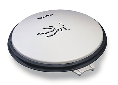
NovAtel Inc. has launched the GPS-704-WB wideband antenna, which supports L-band and the frequencies of all current GNSS constellations (GPS, GLONASS, Galileo and BeiDou), including B3 and E6 signals. Customers can use the antenna for GPS-only or multi-constellation applications, giving application developers flexibility, NovAtel said.
The phase center offset of the antenna remains constant as the azimuth and elevation angle of the satellites change, making it a good choice for baselines of any length. Installation is easy, NovAtel said. because the antenna shares the same form factor as other NovAtel GPS-700 series antennas. It is enclosed in a durable, waterproof housing. Its compact, lightweight size makes it suitable for a wide variety of environments and applications, the company said.
Fugro has commissioned an additional airborne laser bathymetry system to underpin its position in the development and application of bathymetric LiDAR technology. The combined Fugro LADS Mk 3 and Riegl VQ-820-G systems provide seamless measurements and mapping of nearshore and shallow water environments. The increased capability will enable Fugro to deliver simultaneous topographic and bathymetric surveys in multiple geographical areas.
With high power and frequency, the combined systems achieve superior coverage that minimizes gaps and outperforms lower energy alternatives and single-sensor systems in all conditions, particularly in difficult environments, Fugro said. They are highly adaptable and small enough to be installed in a variety of light aircraft.
With continued operations across the Middle East during 2015, Fugro will also begin a South West Pacific ALB survey campaign following the award of projects in multiple locations to support nautical charting, coastal engineering, scientific assessments, coastal management, benthic habitat mapping and climate change initiatives.
Since 2012, Fugro has operated simultaneous topographic and bathymetric LiDAR systems in France, Japan, New Zealand and the Middle East. Successful results from Japanese coastal areas include returns from the Fugro LADS Mk3 sensor to 50 meters while recent surveys in Saudi Arabia had even more impressive results, with 65-meter depth returns. The deep water returns combined with high-density shallow water and near coastal returns result in a seamless dataset from ridge to deep reef.
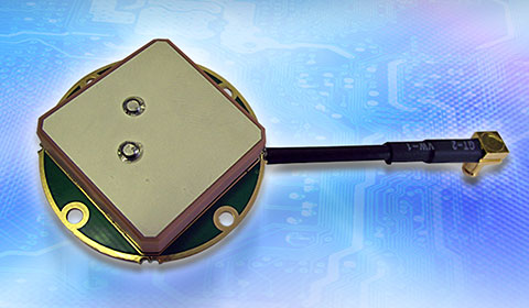
Tallysman’s compact GNSS TW1721 dual-feed embedded antenna with Accutenna technology.
Tallysman, a provider of high-performance, high-quality RF and GNSS components, has announced that its range of antennas featuring proprietary Accutenna technology is optimized for today’s multi-constellation satellite systems, including Europe’s Galileo, China’s next-generation BeiDou, GPS, GLONASS and India’s IRNSS.
Tallysman’s compact GNSS antenna range with Accutenna technology is future-proof: GNSS is changing, and an increasing number of receivers are capable of accessing multiple constellations — GPS, GLONASS, Galileo, BeiDou — but to provide the high precision these new generation of satellites enable also requires new antenna technology.
Tallysman’s proprietary Accutenna dual-feed patch technology used in the company’s wide range of GNSS antennas provides circular response over the entire antenna bandwidth, yielding superior multi-path signal rejection-low axial ratios, tight phase center variation (PCV), and a linear phase response. Single-feed patch antennas, by contrast, only provide a circular response at a single frequency and exhibit poor multipath signal rejection when receiving signals from two or more constellations. A pre-filtering option is available that gives additional protection from near out-of-band signals if required.
“Today’s wideband GNSS signals require a pure right-hand-circular response over a much wider bandwidth,” said Gyles Panther, president of Tallysman. “An inadequate phase response results in poor cross polarization suppression, which simply cannot be overcome in the GNSS receiver chip, regardless of its capabilities. Moreover, multipath interference can be expected, even in normal reception situations. Accutenna technology is a cost-effective way to ameliorate this and is particularly beneficial in situations where precision matters.”
In March, the European Space Agency launched two additional satellites (Galileo 7 and 8). Also in March, the United States launched GPS IIF-9, India launched IRNSS-1D, and China successfully launched its new generation BeiDou-3 M1. The expanding number of satellites will benefit many applications, from next-generation in-car navigation systems to coastguard search and rescue and precision agriculture, Tallysman said.
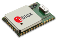
u-blox is offering the CAM-M8C — a small, low-profile GNSS positioning module with an integrated wideband chip antenna for reception across the entire L1 band. The module offers simultaneous GNSS operation for GPS/GLONASS, GPS/BeiDou, or GLONASS/BeiDou to deliver accurate, jamming-resistant and reliable positioning anywhere in the world.
The CAM-M8C integrates a u-blox M8 satellite receiver, crystal oscillator, SAW filter and low-noise amplifier. It also has an input for an external active antenna — when using this option, the internal antenna acts as a backup. Because of its design, the module maintains its performance regardless of physical orientation, making the product suitable for mobile applications with frequent change of bearing.
“Where space is at a premium, for example in emergency call systems, in handheld navigation or in wearable devices, the CAM-M8C module offers a very cost-effective way to bring products to market quickly due to its small size and high levels of integration,” said Kim Kaisti, product manager, Product Center Positioning. “It does this without compromising performance or reliability, and leaves system designers free to concentrate on other important aspects of their product development.”
The CAM-M8C is footprint-compatible with u-blox UC530 and UC530M modules, providing an easy upgrade path, the company said. The module is available now.
To further accelerate design and development, an evaluation kit, EVK-M8CCAM, provides a way to become familiar with the CAM-M8C module and assess its performance in specific applications.
The u-blox M8 GNSS receiver antenna module is delivered in u-blox Professional Grade, and is qualified to JEDS47 and ISO16750 standard “Road vehicles – Environmental conditions and testing for electrical and electronic equipment.” The product is manufactured in ISO/TS 16949 automotive-certified production sites, ensuring the high quality and reliability
Leica Geosystems has announced a group of six major new products for terrestrial laser scanning: three new laser scanners and three new point cloud software products. Together, thes products raise the industry’s bar for laser scanning data quality and productivity, both in the field and the office, Leica said.
Leica ScanStation P40, P30 and P16 Laser Scanners. Leica ScanStations P40, P30 and P16 feature advances in LIDAR and digital imaging as the eighth-generation of Leica Geosystems’ high-performance laser scanners. These new, ultra-high-speed scanners increase field and office productivity, while simultaneously grabbing users’ attention with strikingly sharper, crisper scans and HDR true color images — even under many conditions traditionally difficult for scanning, the company said.
Users will be able to capture more useful data from a single set-up, which translates into fewer instrument setups and greater productivity. Three models meet different user needs: the Leica ScanStation P40 and P30 add survey functionality, longer range capabilities (to 270m for P40), and advanced scanner controls for additional versatility and productivity while the Leica ScanStation P16 is a short-range introductory model.
Point Cloud Software. In addition to the major new software releases Leica JetStream and TruView Global products, Leica Geosystems is now offering Leica CloudWorx for Navisworks — a popular design review application from Autodesk — as its newest family member of CloudWorx plug-ins for CAD and VR applications.
JetStream is a combined project data vault and high-performance data streaming server that takes Cyclone data and serves it up in a high-performance format that enables a CloudWorx user to be up to 40 percent more productive when working with point clouds. Much of that gain comes from instantaneous loading and navigation of point clouds — eliminating traditional “waiting times” long associated with point cloud office work.
Lastly, TruView Global greatly increases anyone’s access to TruViews — Leica Geosystems’ application for viewing and measuring scans. Shaking free from prior constraints, TruViews will be accessible within any Internet browser on any mobile device or computer, with no app or plug-in to install.
Taken together, advances in the new scanners and software elevate laser scanning to a new performance and data quality level, Leica said. The new scanners are all ultra-high speed (up to 1 million points/sec) and can capture more useful data from a scene. In addition, increased user access to TruViews plus good HDR digital images will encourage users to publish TruViews even more frequently.
All of these factors drive users to create more dense scans and larger data sets. With the complementary Leica JetStream software, users have the ability to handle these larger data sets with astonishing ease.
The Leica ScanStation P40, P30 and P16 are immediately available. Leica JetStream, Leica TruVeiw Global and Leica CloudWorx for Navisworks are planned for release Q2 2015.
Sessions on indoor navigation and a keynote from Google at February’s International Navigation Conference (INC15), organised by the Royal Institute of Navigation, addressed the revised E911 positioning requirements in the United States, and flowed over into speculation about E112 emergency calling parameters in Europe’s near future.
According to the 2014 U.S. Federal Communications Commission report, 75 percent of 911 calls now come from mobile phones, more than half of those originate indoors, and around 1 percent of emergency calls contain no location information from the caller (due to distress, confusion, language issues, illness, and so on). The report estimates 10,000 deaths per year in the United States might have been avoided if a landline had been used instead, since location information for landlines can be provided confidently.
Discussion in the breaks of INC highlighted a misunderstanding amongst some parties that E911 mandates the use of GPS for position location determination. In fact,E911 does not mandate any specific technology; it specifies performance criteria in terms of accuracy that must be met. The recently revised performance criteria include indoor performance, and some of the technology discussed at the INC is able to meet these requirements without using GNSS at all.
This could be troublesome for Europe, which is looking at the imposition of Galileo as part of an A-GNSS technology push for the E112 application. The real problems, discussed during INC and in European consultation processes with safety of life services such as E112, are:
the accuracy of the position derived by the device and/or network, and
the timeliness of the delivery of that position to the Public Service Answering Point (PSAP).
The E911 directives address these points directly, and the infrastructure in the cellular networks is in place. Does simply implementing a Galileo capability into a European mobile device solve these problems?
In many outdoor cases, implementing Galileo can bring benefits, including signal diversity. And of course the E112 proposal is greater than just “adding Galileo.” It does address the second problem of timeliness of delivery and data transfer, but there are significant infrastructure upgrades required across Europe for the provision of this location data to the PSAPs.
What the E112 processes do not currently do is specify performance criteria for the position location accuracy. This means that the position estimate provided under E112 is likely to be a cell-ID fix, with an accuracy ranging from hundreds of meters to dozens of kilometers.
Galileo on Mobiles. Further discussion during the conference delved into the realms of the specifics of implementing A-GNSS, including Galileo, onto a mobile device. Conversations centered around if any future E911 or E112 positioning capability would be aligned around a single-chip solution as generally currently deployed on a device, or if some of the functions will be moved up the stack into the operating system (OS) of the device, into software.
Most opinions were against this latter concept, and a panel at the ION GNSS+ last year in Florida concluded the same thing. However, questions were asked about some ideas relating to identifying the emergency number at the time of dialing and then starting the position location determination functions in readiness for the need to provide the device location. This addresses the first bullet point earlier, the accuracy of the position derived by the device and/or network. If this is carried out in the OS or software layers, vulnerability of the system will be increased overall as the OS of a mobile device is a target for the cyber criminal community.
A robust software-based solution is, however, being rolled out in the United Kingdom in the form of eSMS, bringing mobile operators, government and handset vendors together to provide location data via SMS to the PSAP. The advantage of this approach is that no new standards or major infrastructure changes are required, and the time to implement is small.
Further discussions established that future chipsets are likely to use whatever GNSS signals are available, regardless of whether they are GPS, Galileo, GLONASS, Beidou and so on. This, coupled with new signal processing techniques (single-frequency observable for example), increasing sensor clustering on devices, and user demand for services, may make the use of a specific GNSS system above others somewhat redundant. Certainly picking up on a point made by Chandu Thota from Google, GNSS is “not relevant” for their indoor positioning solutions, and technologies they are working on, in both hardware and mapping improvements, are looking at meeting indoor accuracy requirements down to a target requirement of 1 meter, without GNSS.
Taking these points into account, questions were asked from the floor of the conference about the legal position of the EC mandating Galileo as a positioning method as well as the willingness of the global mobile chipset and device industry to be told what to do. Perhaps specifying strong performance criteria, as in the United States, is the way forward to “reboot” the European E112 system. No one disputes that a properly functioning E112 is a life saver and a good thing to do; however, the points discussed here detail some of the concerns expressed during and after hours at INC15.
In February 2015, the Royal Institute of Navigation hosted the International Navigation Conference in Manchester, UK. Keynotes at this well-attended conference included Harold Martin, director of the GPS Coordination Office; Gian Gherardo Calini, the head of market development at the European GNSS Agency; Todd Humphreys from the University of Texas; Chandu Thota from Google; and others. The conference covered multiple technology tracks including indoor navigation, autonomy, quantum technology and the resilience of GNSS systems.
Andy Proctor is lead technologist for satellite navigation at InnovateUK, the UK’s innovation agency. He acknowledges Ramsey Faragher, Cambridge University, for help in the preparation of this article.
Topcon Positioning Group has announced the latest edition of its 3D mobile mapping system. The IP-S3 is on display at the SPAR International 3D Measurement and Imaging Conference, held March 30-April 2 in Houston, Texas. The system employs the integration of an inertial measurement unit (IMU) and GNSS receiver with a vehicle’s onboard electronics to offer high-density mobile digital imaging.
“The IP-S3 is more compact, lightweight, and scans at a rate of up to five times faster than previous models,” said Charles Rihner, vice president of the Topcon GeoPositioning Group. “Weighing in at 39 lbs. (18 kg), it’s light enough that a single person could mount it on a car, truck or SUV without any assistance from anyone else.”
Scanning at 700,000 points-per-second, the rotating LiDAR sensor captures the 360-degree environment with 32 internal lasers. The IP-S3’s six-lens digital camera is designed to provide data-rich results with its 30 MP panoramic imagery.
The system pairs with Topcon Mobile Master Field and Office software suite to perform all post-processing functions in a single application.
“The software suite offers a complete all-in-one processing workflow, turning raw sensor data collected by the IP-S3 system into rich and precise point clouds and images,” Rihner said.
“These sessions will provide attendees and members perspectives on some of the major issues facing the profession,” said John Palatiello, MAPPS executive director, and Curtis Sumner, NSPS executive director. “Our goal from the beginning was to provide conference sessions that are distinct from what surveyors experience at their state conferences. These presentations will give conference attendees and members new insights on the geospatial profession, particularly in the commercial market.”
The speakers for Monday, April 13, are listed below, along with the session name.
Michael Anderson, POB magazine, “POB Top 100″
Bryan Baker, Leica, “What You Need to Know Before Starting Up Your Unmanned Aircraft System (UAS) Department”
Pam Nobles, Rob Garster, “What Is Surveying? A Discussion of Infringing Technologies”
The speakers for Wednesday, April 15, are listed below, along with the session name.
Rhonda Rushing and a panel from Berntsen Inc., “Smart Markers for the Nation’s Land & Infrastructure Assets”
Ted Naak, Certainty 3D, “Establishing Requirements, Extracting Metrics and Evaluating Quality of LiDAR Data”
Neil Sandler and a panel from xyHT magazine, “Are You Prepared for Change?”
The overall conference will serve as an umbrella to include plenary sessions, an exhibit hall, and social and networking activities designed to create synergy among the many vertical segments. It will also feature a “conference within a conference” format, in which participating organizations will hold their own meetings and sessions.
MAPPS will host its annual Federal Programs Conference April 14-15. Presentations by federal agencies, the Obama Administration and members of Congress will include briefings on programs, budgets and requirements for the acquisition of geospatial services, data and products by contract from the private sector.
NSPS will host the finals of its annual Student Competition on April 13. The 2014-15 competition will, for the first time, include not only student teams from four-year degree programs, but also teams from two-year degree programs. The NSPS annual General Membership meeting and other business meetings will be scheduled throughout the week in order to allow NSPS leadership to more fully participate in conference activities.
MAPPS and NSPS members will visit some 200 Congressmen and Senators at the U.S. Capitol, advancing a common agenda of legislative issues that serve the public and engage the surveying and mapping community.
Also on the program will be an invitation-only USGS 3DEP stakeholders meeting, a summit by the National Geodetic Survey (NGS) of the National Oceanic and Atmospheric Administration (NOAA) and a licensed geospatial data forum by the Geospatial Management Office (GMO) of the Department of Homeland Security (DHS).