Category: Receivers

  • SBG Systems introduces Quanta Micro INS for UAV surveying

    SBG Systems introduces Quanta Micro INS for UAV surveying

    Photo: SBG Systems
    Photo: SBG Systems

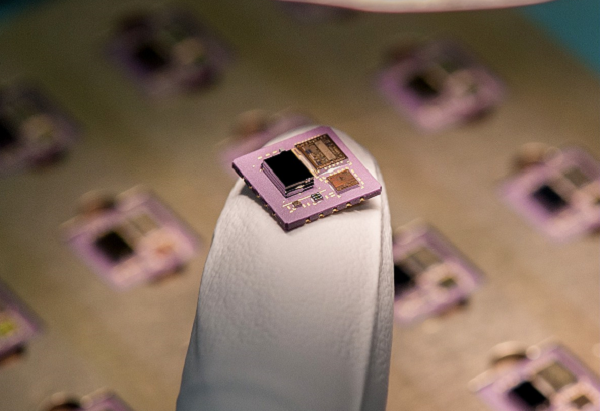
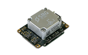
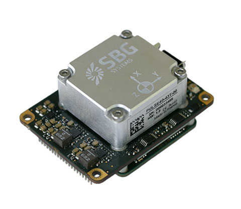
    SBG Systems has launched the Quanta Micro, a navigation system in an extremely compact form factor with a dual-frequency, quad-constellation GNSS receiver for centimeter position with a high-performance inertial measurement unit (IMU).

    The Quanta Micro is a real-time kinematic (RTK) capable, miniature inertial sensor that measures 50 mm x 37 mm x 23 mm and weighs 38 g. Its high-end performance includes centimeter positioning, roll/pitch with less than 0.02° error, and heading with less than 0.06° error. It is suitable for all applications, especially those that have low size, weight, power and cost (SWaP-C) requirements. Quanta Micro has already been selected for the development of lidar payloads for UAV and mobile-mapping systems.

    To achieve such performance in the harshest conditions, Quanta Micro benefits from SBG Systems’ unique experience in designing and manufacturing inertial sensors, including an individual calibration of each of the manufactured sensors across the full range of working temperatures (–40° C to +85° C).

    Lidar point cloud of SBG Systems head office created using the Quanta Micro. (Photo: SBG Systems)
    Lidar point cloud of SBG Systems’ head office created using the Quanta Micro. (Photo: SBG Systems)

    Despite its compact form factor, Quanta micro embeds all the features usually present in the other SBG inertial sensors: a built-in datalogger, Ethernet connectivity, a PTP server, multiple serial ports, a CAN port and more. It is easy to configure with a user-friendly built-in web interface; but can also be configured using SBG systems’ API or ROS drivers.

    While the Quanta Micro supports dual GNSS antenna mode to improve heading accuracy in low dynamic applications, it has been designed to maintain exceptional heading performances even in a single antenna configuration. This makes it the right tool for UAV payloads that cannot embed two GNSS antennas.

    Post processing with Qinertia. To further enhance its extreme real-time performances, the data acquired from the Quanta Micro can easily be post-processed using Qinertia: SBG’s own post-processing kinematic tool. This allows users to process the data with tight coupling of the GNSS and inertial data, and a merge of forward and backward solutions allowing it maintain centimeter precision even during multiple seconds of GNSS outages. It also improves heading errors to less than 0.035° and roll/pitch to less than 0.015°.

  • Tallymatics launches TW5390 antenna with IP network and L-band capability

    Tallymatics launches TW5390 antenna with IP network and L-band capability

    Photo: Tallymatics
    Photo: Tallymatics

    Tallymatics has introduced the TW5390 smart antenna with IP network and L-band augmentation service capability.

    Tallymatics is a division of Tallysman Wireless, a Calian company, specializing in of precision geolocation applications and equipment.

    To create the TW5390, Tallymatics leveraged its experience in GNSS applications, design and manufacturing,  combining Tallysman’s GNSS antenna technology with the high-precision u-blox F9R GNSS receiver and DS9 L-Band receiver modules.

    The combination delivers a reliable and convenient smart antenna yielding <6 cm accuracy, with precise point positioning/real-time kinematic (PPP/RTK) augmentation services via the PointPerfect subscription service.

    The TW5390 solves the complexities of GNSS design — it sends the host system PPP/RTK corrected coordinates in NMEA format over a robust RS-485 interface, assuring results that meet customers’ high expectations.

    Features of the TW5390

    • simultaneous dual-band coverage for GPS, Galileo, GLONASS and BeiDou
    • superior multipath rejection with Tallysman Accutenna technology
    • low noise amplifier
    • Tallysman’s eXtended Filtering (XF) technology, which mitigates saturation from nearby RF signals (targeting
    • LTE and Ligado)
    • tight, measured phase-center offset and low axial ratio, enabling accurate and precise positioning
    • direct decoding of PointPerfect, SPARTN formatted augmentation packets (u-blox specific)
    • IP network and L-band augmentation communications channels
    • built-in inertial measurement unit for UDR and ADR
    • fast convergence time of 40 seconds (PPP/RTK) with < 6 cm accuracy
    • IP69K package
    • RS-485 transceivers
    • Tallymatics SDK available with computer interface, TruPrecision software and 60 days of free PointPerfect
    • service
    • cable lengths of 5, 15 and 25 meters
    • rugged, fixed mount
  • Septentrio’s Stellar 2022

    Septentrio’s Stellar 2022

    Receiver maker Septentrio, based in Leuven, Belgium, has made a series of announcements this year that push the industry forward, from updating existing receivers to accepting new services to launching new product lines.

    Head of the CLAS

    In March, the company launched three new products that support Japan’s high-accuracy Centimeter Level Augmentation Service (CLAS). CLAS, which receives the L6 signal, transmits high-accuracy corrections from Japan’s QZSS constellation. The technology was developed in close cooperation with CORE, a leading integrator of high-accuracy positioning technology and services in Japan.

    Photo: Septentrio
    Photo: Septentrio

    Septentrio now offers the mosaic-CLAS receiver for high-volume industrial applications; the AsteRx-m3 CLAS that combines PPP-RTK CLAS with dual-antenna heading functionality; and the AsteRx SB3 CLAS in a ruggedized IP68 enclosure to protect it in harsh environments.

    Septentrio is simultaneously offering various receiver types to the Japanese market ensuring an optimal match between products and customer needs in various applications including robotics, precision agriculture, construction, machine control and UAV.

    Stopping the Spoofs

    Following the CLAS upgrade, the mosaic line received another boost in April, when Septentrio announced Open Service Navigation Message Authentication (OSNMA) functionality. OSNMA offers end-to-end authentication on Galileo’s civilian signals, protecting receivers from OSNMA attacks.

    For the past two years, Septentrio has been working closely with the European Space Agency (ESA) during the test phases of OSNMA deployment. The know-how gained during this period allowed Septentrio to be one of the first to market with this advanced security feature.

    OSNMA’s anti-spoofing capability complements Septentrio’s Advanced Interference Mitigation (AIM+) technology and further strengthens the overall security of Septentrio GNSS receivers, making them suitable for assured PNT solutions as well as critical infrastructure, such as 5G network synchronization.

    Vertical Markets

    Machine Control. In April, Septentrio launched the AsteRx-U3 ruggedized GNSS receiver, successor to the AsteRx-U for construction, mining and other machine control applications. The new receiver combines Septentrio’s latest triple-band precise positioning GNSS core with extended wireless communication features including Wi-Fi, UHF and 4G LTE. The versatile connectivity features of this receiver make it easy to fit it into any control system and enable simple and cost-effective overall design.

    Photo: Septentrio
    Photo: Septentrio

    Unmanned Aerial Vehicles (UAVs). Also in April, Septentrio is collaborating with MicroPilot, maker of professional UAV autopilots. Septentrio receivers, including the small form factor mosaic modules, as well as the OEM board AsteRx-m3, will support seamless integration of positioning and orientation into MicroPilot’s autopilot ecosystem. MicroPilot chose Septentrio GNSS receivers for their resilience to radio interference such as jamming and spoofing, as well as security and robustness with high-accuracy real-time kinematic (RTK) positioning.

    Marine. In May, Septentrio introduced the housed AsteRx-U3 Marine and the OEM board AsteRx-m3 Fg, two receivers for dredging, marine construction and offshore applications. Both offer accurate positioning near shore and offshore via centimeter-level real-time kinematic (RTK) or the built-in Fugro precise point positioning (PPP) sub-decimeter subscription service, delivered either over NTRIP internet or over L-band satellite.

    Corrections delivered over L-band allow dredging, bathymetry or marine construction projects even in areas where there is no internet service. The AsteRx-U3 Marine receiver, enclosed in an IP68-rated housing, offers a dedicated L-band demodulator with a separate L-band RF input, which allows for the use of dedicated antennas for excellent reception of L-band signals even at high latitudes.

  • U-blox firmware update adds QZSS CLAS to ZED-F9R

    U-blox firmware update adds QZSS CLAS to ZED-F9R

    Photo: u-blox
    Photo: u-blox

    U-blox has released a new firmware update for its ZED-F9R high-precision GNSS dead-reckoning modules. The update extends the range of supported positioning augmentation services.

    With the update, the u-blox ZED-F9R-03B adds support for Japan’s QZSS CLAS correction services, extending the geographical market reach of the ZED-F9R and increasing the scalability of applications using the module. It also now supports SPARTN 2.0, a service from u-blox that delivers correction data based on the SPARTN protocol.

    The ZED-F9R module was designed for use in autonomous automotive and industrial applications that require simple and efficient implementation. It is used where rapid access to highly accurate positioning data is key, even in challenging signal environments such as dense cities. Typical applications include slow-moving use cases such as robotic lawnmowers and shared e-scooters.

    The module has an integrated inertial measurement unit (IMU) for real-time kinematic (RTK) positioning. It employs sophisticated algorithms to fuse the IMU data with GNSS measurements, wheel ticks, correction service data, and a vehicle dynamics model to provide centimeter-level positioning accuracy even in situations where GNSS alone would fail. It is based on the u-blox F9 multi-band GNSS receiver platform, which concurrently tracks up to four GNSS constellations, providing high-quality positioning accuracy.

  • GMV, FrontierSI, Ericsson and Optus prove 5G-based high-accuracy positioning

    GMV, FrontierSI, Ericsson and Optus prove 5G-based high-accuracy positioning

    Trials in Australia are proving 5G LPP can support new positioning services. (Photo: Photo: Dan Woodrow, FrontierSI)
    Trials in Australia are proving 5G LPP can support new positioning services. (Photo: Dan Woodrow, FrontierSI)

    Several companies are joining to demonstrate 5G LTE Positioning Protocol (LPP) capabilities in field trials. The trials are part of the 5G Positioning Testbed funded under the Australian 5G Innovation Initiative.

    Technology partners include GMV, FrontierSI, Ericsson and Optus, who are joining with industry demonstration partners Kondinin Group, Platfarm (a precision agriculture company) and Position Partners.

    The results achieved by the project are considered a key step forward for the use of 5G technology for high-accuracy positioning. The testbed demonstrated each of the high accuracy GNSS-based LPP working modes, including Observation Space Representation (OSR), State Space Representation (SSR), and SSR with atmospheric corrections, integrated directly with user equipment supplied by demonstration partners to examine a variety of real-world applications. The field trials demonstrated that the solution can reach centimeter-level accuracy with fast convergence times using a commercial off-the-shelf receiver and antenna hardware.

    GNSS precise positioning is the most common technology for calculating an absolute positioning solution at the user level. For uses requiring centimeter-level accuracy, it is often required to provide GNSS corrections to reduce errors.

    Distribution of GNSS corrections is based on either the broadcast of precise point positioning (PPP) corrections through GEO satellites over the L-band, or the point-to-point transmission of real-time kinematic (RTK) corrections using NTRIP through the internet.

    Both options have their drawbacks: GEO satellite broadcast requires complex ground infrastructure and can be expensive to maintain, while NTRIP distribution has poor scalability due to the point-to-point connections required for every user.

    3GPP (3rd Generation Partnership Project) — the standards organization focusing on 5G LPP — recently introduced the support of OSR corrections for RTK users in Release 15, and the support of SSR plus atmospheric corrections for PPP/PPP-RTK users in Release 16.

    Support for these two approaches to high-accuracy GNSS positioning have increased interest in 5G LPP as a potential alternative to existing correction services. Service providers and positioning consumers can now consider the use of 5G LPP as a supporting technology in the provision of new positioning services directly through mobile networks.

    The 5G Positioning Testbed has achieved end-to-end demonstrations of high-accuracy positioning solutions using GMV’s Corrections Service and Positioning Engine, delivered through the Optus 5G network using Ericsson network technology, to user equipment designed and operated by FrontierSI.

    Field trials conducted in Australia involved real-world scenarios across three areas: precision agriculture, drone operation and augmented reality.

  • Next-gen Unicore GNSS hardware available through Rx Networks 

    Next-gen Unicore GNSS hardware available through Rx Networks 

    Photo: Unicore
    Photo: Unicore

    Rx Networks is offering for both the North and South American markets the next-generation high-precision GNSS modules from Unicore Communications, based in China.

    Based on the new NebulasIV systems-on-chip (SOC), the UM960, UM980 and UM982 modules offer all-constellation, multi-frequency, high-precision real-time kinematic (RTK) positioning and heading capabilities.  


    Rx Networks is exhibiting at  ION-GNSS+ taking place this week in Denver, at Booth 108, and will exhibit at  Intergeo in Essen, Germany, Oct. 18-20, at Booth F2.033.


    Available in a small footprint with low-power consumption, the Unicore modules are suited for use in reference stations, surveying and mapping, precision agriculture, heading applications, machine control, drones and robotics, vehicle navigation, precision timing, and more.

    Photo: Unicore
    Photo: Unicore

    Rx Networks is a key supplier of high-accuracy services and assistance data to a growing list of GNSS hardware manufacturers. As high-precision GNSS becomes ubiquitous, those seeking precise positioning solutions can now have Unicore GNSS hardware enlightened with Rx Networks data services.

    “We are pleased to be bringing this new leading GNSS Technology into the Americas,”  said Cameron Baird, head of Business Development, GNSS Hardware. “With further product miniaturization coupled with added performance, features and functionality, Unicore GNSS technology is well suited for all precision GNSS applications.”

    Email [email protected] for details.

  • Unicore releases dual-antenna RTK module, the UM982

    Unicore releases dual-antenna RTK module, the UM982

    Photo: Unicore
    Photo: Unicore

    Unicore has released its new generation of GNSS positioning product, the UM982. The UM982 is a high-precision dual-antenna real-time kinematic (RTK) positioning and heading module supporting all constellations and all frequencies.

    The UM982 is suitable for use in UAV, precision agriculture and autonomous machine applications. The module is designed to meet the requirements of  these markets, providing technological innovation. The module supports BDS B1I/B2I/B3I, GPS L1/L2/L5, GLONASS L1/L2, Galileo E1/E5a/E5b, QZSS L1/L2/L5 and SBAS in dual-antenna mode. It offers the following advantages.

    Small size. The UM982 is highly integrated. With its size of 16.0 × 21.0 × 2.6 mm, it is a compact dual-antenna heading modules that reduces the design area of the customer’s board by 72% compared to previous modules.

    Low power consumption. Low power consumption means less energy usage and a better application experience. Lowering the power consumption while keeping performance high is one of the key technical research directions of the GNSS positioning modules. The average power consumption of all versions of the UM982 module is less than 0.6 W, which is suitable for applications that require low power consumption, such as UAVs.

    High integration. The UM982 was developed on the basis of NebulasIV, Unicore’s proprietary GNSS system on chip (SoC). NebulasIV integrates RF, baseband and high-precision algorithms on a single chip, with built-in functions providing powerful support for the UM982’s high performance.

    High precision and high performance. The GNSS SoC is a key part of the navigation system, and the performance of the chip largely determines the performance of positioning modules. High-level performance indicators include raw observation accuracy, RTK positioning accuracy, PPP positioning accuracy, and time to first fix.

    Robustness. Using the company’s dual-RTK technology, the UM982’s two antennas can independently participate in deriving an RTK solution and outputting the positioning results. This is convenient for customers conducting reliable verification in various application scenarios. By checking the RTK positioning results of both antennas, abnormal measurements in complex scenarios can be avoided.

    High reliability. A built-in, advanced anti-jamming unit provides the UM982 with strong anti-jamming ability. The module detects jamming and can output the jamming strength. It also supports digital encryption to ensure the security of data transmission, and supports multi-frequency independent acquisition and tracking to ensure the reliability and accuracy of positioning results even in complex electromagnetic environments.

  • Unicore releases GNSS RTK module, the UM980

    Unicore releases GNSS RTK module, the UM980

    Photo: Unicore
    Photo: Unicore

    Unicore Communications has released its new generation of high-precision GNSS module. The UM980 uses real-time kinematic (RTK) technology to achieve centimeter-level positioning accuracy.

    The UM980 is based on the small high-performance system-on-chip NebulasIV, which integrates radio frequency, baseband and high-precision algorithms on a single chip. It has 1,408 channels to concurrently receive satellite signals from multiple constellations and multiple frequencies.

    The UM980 module can track BDS B1I/B2I/B3I/B1C/B2a/B2b, GPS L1/L2/L5, GLONASS L1/L2, Galileo E1/E5a/E5b/E6 and QZSS L1/L2/L5, as well as supporting SBAS.

    Its advanced multi-mode multi-frequency computing engine provides powerful signal processing ability, characterized by fast initialization time, accurate positioning results, and a high data-update rate of up to 20 Hz.

    The UM980 features low power consumption, typically 480 mW. The module is a surface mount device (SMD) measuring 17 x 22 x 2.6 millimeters. Compared to Unicore’s previous generation of high-precision GNSS modules, the UM980 is nearly half the size while the performance remains excellent.

    The UM980’s compact form occupies less printed-circuit-board area and makes the product more portable. The UM980 is also equipped with an advanced anti-jamming unit, which ensures high reliability even in complex electromagnetic environments.

    Thanks to its high precision, high performance and high reliability, UM980 is suitable for applications in surveying, mapping and precision agriculture. The UM980 is qualified according to the international quality standards (RoHS, REACH, CE, FCC, and IC) and is in mass production.

  • Antenova adds Agosti antenna for scaled-down GNSS designs

    Antenova adds Agosti antenna for scaled-down GNSS designs

    Photo: Antenova
    Photo: Antenova

    Antenova Ltd. is adding a new offering to its range of miniature surface-mount-designed (SMD) antennas and modules for GNSS applications. The new antenna, Agosti (part number SR4G080), measures 9.0 x 5.8 x 1.7 mm and operates with exceptional efficiency in a reduced space on a corner of a printed circuit board (PCB).

    The key advantage of the Agosti antenna is its small ground-plane requirement. Most SMD antennas use the surface of the PCB around the antenna as a ground plane from which to radiate the signal — the ground-plane requirement, not the physical dimensions of the antenna, define the space it needs.

    Antenova’s radiated measurement results show Agosti operating well on small ground planes of 40 x 20 mm, 70 x 25 mm and 80 x 30 mm, making it a suitable choice for small form-factor designs, such as small wearable devices, trackers and on-board diagnostics (OBDs).

    Agosti is designed to integrate and co-exist with other antennas within the same device. OBDs and trackers often use 4G/LTE with A-GPS for fallback. The Agosti antenna has been tested with Antenova’s Pharoah antenna (part number SR4L073), which also has a very small ground-plane requirement. The two antennas have excellent isolation and can operate in close proximity to each other in a very small device without the 4G signal interfering with sensitive GNSS signals.

    “Small SMD antennas such as Agosti are an exciting alternative to the common delicate ceramic patch antennas used in GNSS designs,” said Michael Castle, product marketing manager, Antenova. “This is not just because the SMD antennas are significantly smaller. It is also because they provide omni-directional performance.

    “Patch antennas are typically 12 mm or 14 mm square, are heavier than SMD antennas, and need a much larger ground plane and keep-out area,” Castle said. “They also have to be placed in the center of a circuit board and only work well when they point at the sky. Antenova’s new generation of SMD antennas overcome all of these limitations and perform well regardless of position and orientation of the device.”

  • Harxon launches dynamic website with antenna selection feature

    Harxon launches dynamic website with antenna selection feature

    Image: Harxon
    Image: Harxon

    Antenna manufacturer Harxon has launched a new company website, which features eye-catching animations and dynamic illustrations.

    “We’ve optimized the website in both the layout and the content,” the company stated in a news release. “You’ll find more detailed product pages, seven major industry applications, and more information about Harxon Corporation.”

    New additions include Antenna Customization and Antenna Selection pages, designed to help customers determine which products meet their project needs.

    Harxon’s latest products include the survey GNSS antenna HX-CSX633A, the ruggedized HX-CVX606A and the X-Survey OEM antenna HX-CSX179A.

  • Safran develops inertial micro-sensor strategy

    Safran develops inertial micro-sensor strategy

    An example of a MEMS. (Photo: Safran Colibrys)
    An example of a MEMS. (Photo: Safran Colibrys)

    Safran Electronics & Defense is taking a major step forward in its inertial navigation strategy by grouping two subsidiaries, Safran Colibrys (Switzerland) and the recently acquired Sensonor (Norway,) under a single banner, Safran Sensing Technologies.

    The similarities in expertise, market position, customers and technologies result in clear synergy between these two companies, which produce accelerometers, gyrometers and inertial measurement units (IMUs). The creation of Safran Sensing Technologies shows Safran’s commitment to developing its micro-sensor business through these two companies.

    The STIM380H inertial measurement unit. (Photo: Sensonor)
    The STIM380H inertial measurement unit. (Photo: Sensonor)

    The goal is to jointly offer a wider and comprehensive range of inertial technologies including vibrating sensors, optics and micro-electromechanical system (MEMS) for applications in aeronautics, defense, space and other industries.

    The two subsidiaries have already delivered more than 20 million MEMS sensors to the aeronautics, defense, space, transport, mobility and industry sectors. For example, MEMS are used in the control accelerometers of automobile airbags, in high temperature accelerometers for guiding drill heads, and in seismic sensors measuring the structural health of buildings or civil engineering works. They are also used in IMUs for civil, military and space vehicles.

    This change is part of a broader Safran Electronics & Defense strategy designed to strengthen the company’s position in the positioning, navigation and timing (PNT) market.

    The two entities have been renamed Safran Sensing Technologies Norway AS and Safran Sensing Technologies Switzerland SA, respectively.

  • SBG Systems launches Quanta Micro INS

    SBG Systems launches Quanta Micro INS

    Photo: SBG Systems
    Photo: SBG Systems

    SBG Systems has announced a new inertial navigation system (INS) named Quanta Micro, completing its Quanta product line.

    The Quanta Micro GNSS-aided INS offers a unique combination of navigation performance and low size, weight, power and cost (SWAP-C).

    Quanta Micro leverages a survey-grade inertial measurement unit (IMU) for optimal heading performance in single antenna applications, and high immunity to vibrating environments. An optional secondary antenna enables fast heading initialization in low dynamic applications.

    Main Features

    • Accuracy: 0.015° roll/pitch, 0.035° heading, 1 cm position (PPK)
    • Integrates a survey-grade IMU: 0.8°/h gyro bias instability
    • Versatile INS/GNSS to suit land, air or marine applications
    • Highly tested and calibrated from -40°C to 85°C
    • Robust to vibrating environments
    • Quad-constellation multi-band RTK GNSS receiver
    • Smooth post-processing workflow with Qinertia software
    • Major size reduction with no compromise on performance.