iGage Corporation announces the introduction of a simple, low-cost, L1/L2/L2C GPS receiver specifically designed to use the National Geodetic Survey’s OPUS online post-processing service. The X90-OPUS has a single button interface and customized firmware/software to automate data submissions to OPUS for centimeter-level post-processing anywhere in the United States.
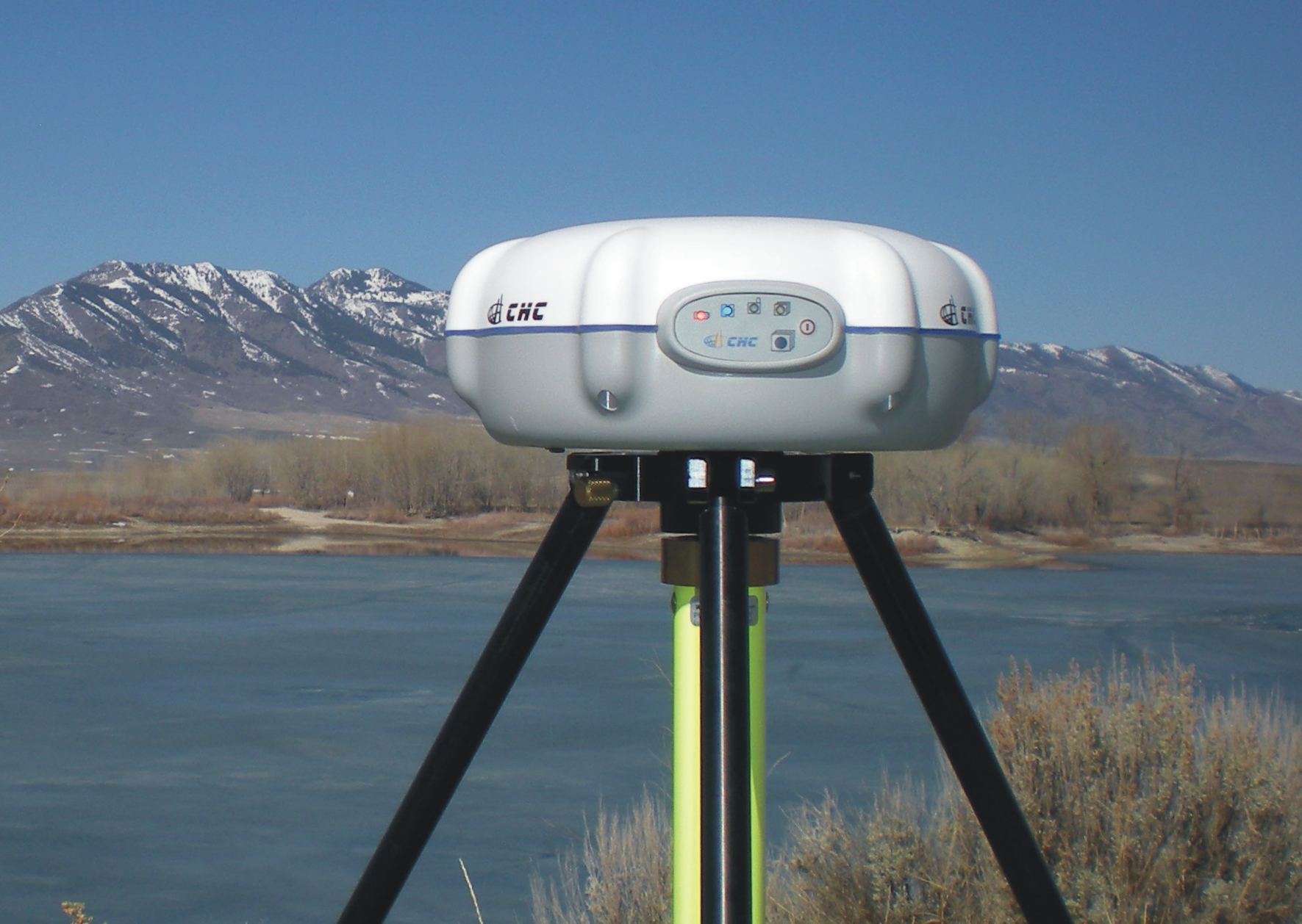
At only US$2,450, iGage reports that the X90-OPUS is the least expensive L1/L2 GPS surveying receiver in the world. Its 4GB internal memory stores more than four years of 15-second interval data. A simple plug-and-play USB connection behaves exactly like a USB memory stick on the user’s computer for easy data download.
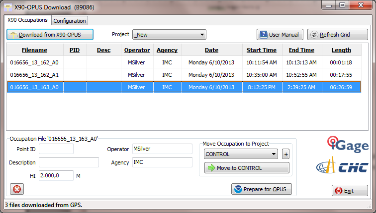
The X90-OPUS Download software has single button download. Another button press decimates occupation data, ZIPS the observation file, and automatically fills in the entire OPUS online submission form.
Photo: iGage
According to the announcement, the X90-OPUS makes field surveying easy, no data collector is required just press the power button to begin and end an observation.
“We have taken our years of static GPS surveying experience and boiled it down to a simple one-button operation,” said Mark Silver, President of iGage. “You turn it on and it works. There are no data collectors and no complicated displays. It is drop-dead simple.”
The X90-OPUS receiver is waterproof, submersible, nonincendive, and it floats (IP-67). It carries a standard two-year warranty. The package includes two rechargeable batteries, a dual slot charger, external power cable, and hard shell carrying case.
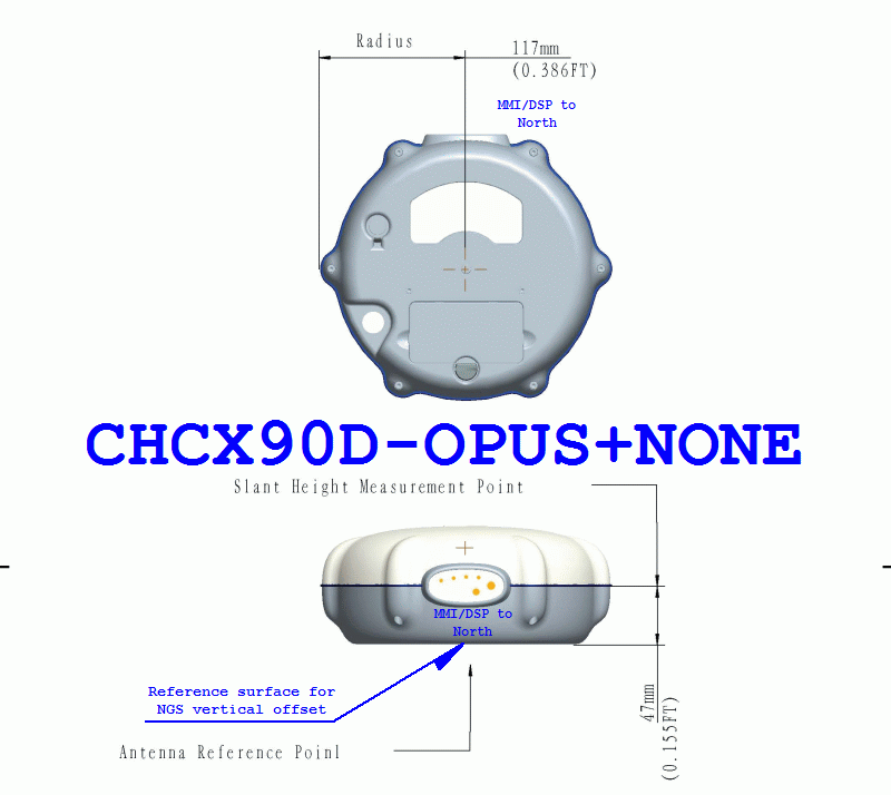
At 3.1 lbs and less than 8” in diameter, the 24-channel L1/L2/L2C X90-OPUS is ideal for surveying using OPUS, OPUS-RS, OPUS Projects, and standard static surveying campaigns. With a low cost of ownership, the X90-OPUS virtually eliminates the need for “leap-frogging” GPS receivers in large static campaigns.
The X90-OPUS is available immediately. Details are available at http://www.x90gps.com.
In the more than 100+ articles I’ve written for GPS World magazine over the past seven years, I don’t think I’ve ever written about a new product introduction like you will see below. I tend to focus on GNSS and geospatial technologies rather than a brand-specific products and services. In fact, last week I had an outline prepared for my article that included some really cool free and useful GPS/GNSS apps. I decided to set that outline aside until later, in favor of writing about this product.
Although certainly different than mainstream GPS/GNSS receivers, I wouldn’t refer to this new product as a disruptive one (a marketing term used to describe something that is industry-changing) and it doesn’t incorporate leading-edge GPS/GNSS technology. In fact, it’s relatively low-tech in comparison to the other GPS/GNSS surveying receivers available in the marketplace.
Even more fascinating is the fact that the product was developed not by any of the mainstream GPS/GNSS receiver manufacturers you hear about today, but rather an electrical engineer from Utah who leveraged the design/manufacturing expertise of one of China’s largest manufacturers of GPS/GNSS surveying receivers.
The final nail in the coffin is the fact that I’ve expended thousands of words in GPS World denouncing the future of post-processing and celebrating the virtues of high-precision, real-time GNSS (RTK, SBAS, PPP) receivers.
I tried to talk myself out of writing this article more than once, telling myself that I’ve never written specifically about a new product and I wasn’t going to start now. But, as much as I didn’t want to, I always came back because it is so darned compelling.
While the product is not aligned with my vision of real-time being the future of high-precision GNSS receivers, it is perfectly aligned with my vision that the cost of high-precision GNSS receivers are dropping and will continue to decline considerably over the next few years.
However…it is incredibly inexpensive, and it is designed to be perfectly simple to operate.
iGage X90-OPUS Photo: iGage
In one sentence, the X90-OPUS is a one-button, dual-frequency GPS receiver that is specifically designed to use the National Geodetic Survey’s free online OPUS post-processing service to achieve centimeter-level GPS positioning anywhere in the United States and surrounding countries.
You might say to yourself, “So what? There are plenty of GPS receivers on the market that are capable of providing this functionality.” I would make the same comment, except it has one product feature that I’ve never seen before.
The Price
What makes the X90-OPUS so compelling is its low cost. The X90-OPUS GPS receiver sells for US$2,450, including all software and accessories (except for tripod/tribrach) that allow you to submit GPS data files to OPUS in a very automated fashion.
At US$2,450, the X90-OPUS may open a new world for surveyors, engineers, and scientists who have previously shunned high-precision GPS receivers due to their high cost and complexity.
Simplicity
For those of you who yearn for the yesteryear of the one-button Ashtech’s legacy Locus GPS receiver, the X90-OPUS reminds me of that sort of simplicity, but on steroids. The X90-OPUS is a dual-frequency (L1/L2) receiver, while the Locus was a single-frequency receiver. The difference is that one can use OPUS and the other cannot. OPUS post-processing doesn’t support single-frequency GPS receivers. However, Mark Silver, the electrical engineer from Utah, has taken it a step further by developing software that automates the OPUS data submission process. Although I’ve made it clear in the past that I’m not a fan of post-processing, it doesn’t get any easier than this. You don’t need to buy a base station, and you don’t need to own post-processing software. It’s a two-button push operation: once to turn it on, and once to turn it off.
X90-OPUS Software Photo: iGage
The X90-OPUS receiver was characterized by the National Geodetic Survey back in March 2013 and is listed on the NGS’s Individual Antenna Calibration website.
Photo: iGagePhoto: iGage
Pertinent Background
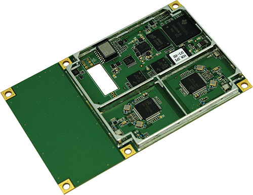
You might think that with the US$2,450 price point and not being offered by a major GPS receiver manufacturer, this is some home-brew GPS receiver. If you thought that, you would be incorrect. The GPS engine in the X90-OPUS is a Pacific Crest BD950, the same engine found in many receivers from other GNSS system manufacturers. CHCNav integrated the GPS engine into its casing to produce the X90 receiver. However, Mark added his own special sauce to the X90 to turn it into the X90-OPUS so this isn’t just a CHCNav receiver being marketed by iGage (Mark’s company).
In all fairness, I’ve not touched the X90-OPUS yet. I likely will in the next few days. However, unless the hardware is unreliable, I don’t see how this product is not going to be a winner, and it will introduce high-precision GPS receivers to an entirely new group of surveyors, engineers and scientists who have been holding out on using GPS.
Summary: A look at the challenge of dealing with horizontal datums in your GIS. We are moving into a new era in dealing with datum transformations. Geodata 2.0 is coming, and it can create big headaches when attempting to combine disparate geospatial databases. Sensors such as GPS receivers, remote sensing imagery, and 3D scanning provide much more accurate data, setting up a collision with outdated and mismatched legacy horizontal datums.
Speakers:
Kevin Kelly, Geodesist, ESRI, Inc.
Kevin Kelly is a Geodesist with ESRI in Redlands, California where he researches and implements geodetic algorithms and applications for the ArcGIS software. His experience spans over 35 years in hydrography, geodesy, surveying and most recently, geographic information systems. He has held the posts of Manager of Geodetic Services for the Province of Ontario, Chief Geodesist for the Kingdom of Saudi Arabia’s Military Survey Department and Senior Project Surveyor for The Keith Companies (now Stantec, Inc.). Mr. Kelly received a Master of Applied Science in Geodesy at the University of Toronto, Canada and holds an Honors Diploma in Hydrographic Surveying Technology from Humber College in Toronto. He is also a licensed Geodetic Surveyor in the Province of Ontario, Canada.
Craig Greenwald, Technical Director, GeoMobile Innovations
Craig Greenwald is the Technical Director and a principal at GeoMobile Innovations Inc. He has worked in the GPS and Mobile GIS industry for over 13 years, including seven years for GIS software leader, ESRI and is well known for his work on the ESRI ArcPad team. Craig leads the GeoMobile software development and consulting team specializing in Mobile GIS and field data collection applications and technology providing Mobile GIS software, consulting, and training services to GeoMobile Innovations? clients. Craig has real world experience designing, implementing, and consulting on all sizes of projects, ranging from local campground trash mapping to the U.S. national census, and has been a key developer in GeoMobile?s commercial applications such as LaserGIS for ArcPad and Geo-Photo Inventory Tool for Garmin GPS solutions.
Michael L. Dennis, RLS, PE, Geodesist, NOAA
Michael L. Dennis, RLS, PE, is a geodesist at NOAA’s National Geodetic Survey (NGS) where his duties include analysis of geometric (“horizontal”) and vertical datums; evaluation of data processing and survey network adjustment procedures; development and promotion of standards and guidelines; integration of NGS products and services with GIS; and public outreach. Mr. Dennis is also a registered professional engineer and surveyor with private sector experience, including ownership of a consulting and surveying firm. Mr. Dennis is an officer of the American Association for Geodetic Surveying (AAGS), an American Congress on Surveying and Mapping (ACSM) Fellow, and a member of the Arizona Professional Land Surveyors Association and the Geomatics Division of the American Society of Civil Engineers.
Moderator:
Eric Gakstatter, Editor of Geospatial Solutions Monthly and Survey Scene
Eric Gakstatter has been involved in the GPS/GNSS industry for more than 20 years. For 10 years, he held several product management positions in the GPS/GNSS industry, managing the development of several medium- and high-precision GNSS products along with associated data-collection and post-processing software.
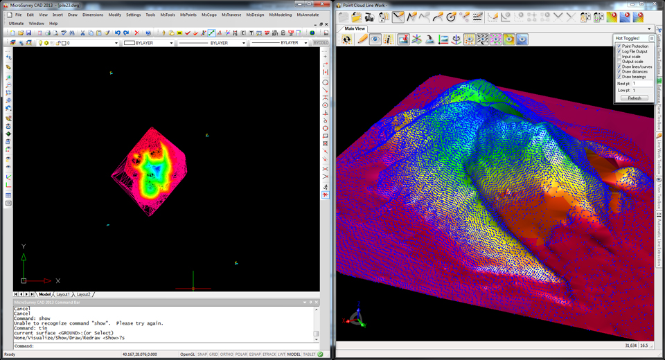
MicroSurvey, the maker of MicroSurvey CAD and the MapScenes System, announces the release of three new software versions optimized to make full use of datasets from the new Leica Nova MS50 MultiStation. MicroSurvey CAD Ultimate 2013, MicroSurvey CAD Studio 2013 and MapScenes PointCloud 2013 provide complete point cloud and Leica Nova MS50 support in an intuitive interface that allows users to quickly and easily integrate 3D point cloud data into their workflows.
Photo: MicroSurvey
MicroSurvey CAD Ultimate 2013, the desktop survey and design software solution for surveyors, contractors and engineers, provides a familiar field-to-finish CAD survey solution with the Leica Nova MS50 MultiStation. With just a few clicks, users can easily import datasets from the Leica Nova MS50 complete with all TPS measurements, pictures, points and scan data. For users who need to enhance their data visualizations with fly-through movies and animations, MicroSurvey CAD Studio 2013 includes all the functionality of MicroSurvey CAD Ultimate plus a powerful animation module capable of creating stunning movies.
MapScenes 2013, drafting, point cloud data visualization and animation tool for forensic investigators, accident scene reconstructionists and other public safety professionals, now includes the ability to take advantage of the rich 3D datasets captured by the Leica Nova MS50 MultiStation. MapScenes 2013 lets the user quickly and easily draw in the point cloud view for extremely fast, accurate linework as well as use the scan data from the Leica Nova MS50 in animations for accurate and compelling reconstructions.
MicroSurvey CAD Ultimate 2013, MicroSurvey CAD Studio 2013 and MapScenes 2013 are available as optional software packages with the Leica Nova MS50 MultiStation. For more information, visit www.microsurvey.com or www.mapscenes.com.
Leica Geosystems has launched Pegasus:One, a flexible, mobile mapping platform that offers an intuitive mobile mapping solution for professionals. Pegasus:One allows service providers to use their existing terrestrial scanner in profiler mode for mobile mapping. Pegasus:One is vehicle independent and comes self-contained in two Pelican cases, enabling users to fly in, map, and fly out.
The Leica Pegasus:One mobile mapping software platform, ArcGDS, draws on synergies resulting from Leica Geosystems’ recent acquisition of Geosoft S.r.l. and is a complete solution from data acquisition to post-processing to database, Leica Geosystems said. It offers users immediate access to their imagery and point cloud data together in the same GUI. Users navigate visually through their images, clicking in their street views, and can add GIS metadata or calculate distances on the fly. Both the imagery and point cloud are calibrated together, so clicking in one immediately provides access to the data in the other.
With nearly 1 billion stop signs and 3.9 million miles of public road in the United States alone, transportation-related asset management provides substantial opportunities, Leica Geosystems said. Additionally, the introduction of new driver assisted technology for cars is putting tremendous pressure on transportation departments to document their highway systems to enable this technology to work successfully. The Leica Pegasus:One provides a solution for both applications.
In the United States, more than 700 thousand billboards exist with new laws limiting the total number of billboards allowed and their placement. Ensuring compliance will generate revenue for states and municipalities around billboard placement, and is now cost effective with the Leica Pegasus:One platform – by simply driving by, Leica Geosystems said.
“Leica Pegasus:One is an enabling product,” said Stuart Woods, vice president for Leica Geosystems’ Geospatial Division. “By providing a single integrated solution and by making our customers’ scanners mobile, we enable our customers to be more efficient.”
In situations where users want or can only afford to capture images, Leica offers an image-only system without a scanner. This provides the same calibrated camera and leverages photogrammetry software to calculate distances from the images – ideal for GIS applications. No longer is the only option a “video recorder on wheels” — now images can be used for distance calculations, Leica Geosystems said.
GPS World’s next webinar, “Nightmare on GIS Street: GNSS Accuracy, Datums and Geospatial Data,” is accepting registrations. The webinar will be held Thursday, June 20, 10 a.m. PDT / 1 p.m. EDT / 6 p.m. GMT. Registration is free.
“‘Nightmare on GIS Street: GNSS Accuracy, Datums and Geospatial Data’” is a look at the challenge of dealing with horizontal datums in your GIS,” explained moderator Eric Gakstatter, survey editor and editor of Geospatial Solutions. “We are moving into a new era in dealing with datum transformations. Geodata 2.0 is coming, and it can create big headaches when attempting to combine disparate geospatial databases. Sensors such as GPS receivers, remote sensing imagery, and 3D scanning provide much more accurate data, setting up a collision with outdated and mismatched legacy horizontal datums.”
Scheduled speakers include:
Kevin Kelly,Geodesist, ESRI, Inc.
Kevin Kelly is a Geodesist with ESRI in Redlands, California where he researches and implements geodetic algorithms and applications for the ArcGIS software. His experience spans over 35 years in hydrography, geodesy, surveying and most recently, geographic information systems. He has held the posts of Manager of Geodetic Services for the Province of Ontario, Chief Geodesist for the Kingdom of Saudi Arabia’s Military Survey Department and Senior Project Surveyor for The Keith Companies (now Stantec, Inc.). Mr. Kelly received a Master of Applied Science in Geodesy at the University of Toronto, Canada and holds an Honors Diploma in Hydrographic Surveying Technology from Humber College in Toronto. He is also a licensed Geodetic Surveyor in the Province of Ontario, Canada.
Craig Greenwald, Technical Director, GeoMobile Innovations
Craig Greenwald is the Technical Director and a principal at GeoMobile Innovations Inc. He has worked in the GPS and Mobile GIS industry for over 13 years, including seven years for GIS software leader, ESRI and is well known for his work on the ESRI ArcPad team. Craig leads the GeoMobile software development and consulting team specializing in Mobile GIS and field data collection applications and technology providing Mobile GIS software, consulting, and training services to GeoMobile Innovations? clients. Craig has real world experience designing, implementing, and consulting on all sizes of projects, ranging from local campground trash mapping to the U.S. national census, and has been a key developer in GeoMobile?s commercial applications such as LaserGIS for ArcPad and Geo-Photo Inventory Tool for Garmin GPS solutions.
Michael L. Dennis, RLS, PE, Geodesist, NOAA
Michael L. Dennis, RLS, PE, is a geodesist at NOAA’s National Geodetic Survey (NGS) where his duties include analysis of geometric (“horizontal”) and vertical datums; evaluation of data processing and survey network adjustment procedures; development and promotion of standards and guidelines; integration of NGS products and services with GIS; and public outreach. Mr. Dennis is also a registered professional engineer and surveyor with private sector experience, including ownership of a consulting and surveying firm. Mr. Dennis is an officer of the American Association for Geodetic Surveying (AAGS), an American Congress on Surveying and Mapping (ACSM) Fellow, and a member of the Arizona Professional Land Surveyors Association and the Geomatics Division of the American Society of Civil Engineers.
Moderator:
Eric Gakstatter, Editor of Geospatial Solutions Monthly and Survey Scene
Eric Gakstatter has been involved in the GPS/GNSS industry for more than 20 years. For 10 years, he held several product management positions in the GPS/GNSS industry, managing the development of several medium- and high-precision GNSS products along with associated data-collection and post-processing software.
Hemisphere GNSS has launched its new Crescent Vector H200 GNSS compass module, a high-performance receiver for heading, positioning, heave, and attitude. Vector H200 is designed for professional marine, navigation, and land applications in challenging and dynamic environments.
Vector H200 processes L1 GPS and GLONASS signals to deliver precise heading, greater positioning reliability, and better performance in challenging environments, Hemisphere GNSS said. Through using two separate antennas, Hemisphere GNSS’ patented Vector technology computes the heading and pitch or roll angle while stationary or in motion. Vector H200 can compute heading accuracy to 0.02 degrees using a 5-meter antenna separation. A variety of differential correction methods also make it possible for Vector H200 to provide sub-meter to centimeter position accuracy.
Marine industry developers can maximize performance by integrating Vector H200 into their systems for hydrographic and bathymetric surveys, auto-pilots, dredging, and buoys. For land applications, Vector H200 is ideal for aligning cameras, antennas and projectiles, and for machine control applications in agriculture, construction, and mining.
“System integrators have a lot to gain from Vector H200’s powerful combination of navigation and machine control orientation capabilities,” said Ron Ramsaran, Sr. Product Marketing Manager at Hemisphere GNSS. “They will appreciate the performance and value from such a small board package.”
Vector H200 supports SBAS, L-Band and RTK differential positioning solutions and features our exclusive SureTrack technology optimizing the use of GPS and GLONASS signals. Hemisphere GNSS offers precise GNSS antennas to fit a variety of Vector H200 applications.
Newly released Leica GeoMoS 6.0 software includes automatic scanning and deformation analysis integrating the new Leica Nova MS50 MultiStation to scan areas of inaccessible manmade and natural structures. The monitoring data is also processed automatically with the new n.Vec technology implemented by Leica Geosystems. Color-coded, visualized 3D deformation clouds enable easy analysis and interpretation of movements so users can make the right decisions to rectify static problems or protect peoples’ lives.
Leica Geosystems announced version 6.0 at a media event held during the HXGN Live conference in Las Vegas today.
Leica GeoMoS Scanning is an automatic scanning solution fully integrated into Leica GeoMoS Monitoring Solution. This ensures fast integration with existing Leica GeoMoS projects and an easy start for new users, Leica said. In addition to total stations, GNSS, tilt and geotechnical sensors, highly detailed scanning can now be added to the automated measurement cycle. The new scanning module is easy to configure and provides the complete workflow for automatic acquisition and processing of the data to visualize deformations and to notify key personnel in the case of an event. With Leica GeoMoS Web, the data can be accessed anywhere at any time. Leica GeoMoS 6.0 enhances conventional monitoring methods with automatic scanning of surfaces with the Leica Nova MS50 MultiStation. Used for inaccessible places or locations where prisms cannot be installed, e.g. a road cover, a roof, a pipeline or a natural structure, Leica GeoMoS real-time scanning solution monitors any deformation and makes sure that no movement is undetected. The big advantage of using the Leica Nova MS50 MultiStation is that it combines laser scanning and prism monitoring, and therefore the measurements to stable control points guarantee highly accurate setup corrections, including orientation and translations. Additional imaging functionality complements the set by providing yet another information source for better deformation analysis. The implemented scan wizard allows the image-assisted definition of scan areas using different parameter settings and different scan result types. Once defined, the scan area can be scanned manually and via the automatic measurement cycle.
Leica GeoMoS 6.0 enhances conventional monitoring methods with automatic scanning of surfaces with the Leica Nova MS50 MultiStation.
The new scanning feature uses all current automatic functionalities such as automatic measurement cycle scheduling, real-time notification via e.g. SMS/email, automatic limit level check, etc. In addition, the embedded point cloud and image viewer assures powerful 3D visualization of all results using color-coded deformation clouds with a fully traceable history of deformations of the scanned area.
The new n.Vec technology in Leica GeoMoS 6.0 provides automatic scan cloud processing to deliver the real-time information about deformations. The data can quickly and easily be interpreted for informed decisions. Leica Geosystems’ unique n.Vec processing technology uses normal vectors to determine movements in man-made and natural structures through color-coded deformation maps. The deformation maps are created by comparing normal vectors from a reference epoch and the current epoch. To ensure maximum deformation interpretation quality, in an iterative and fully automatic procedure, n.Vec removes non-surface related scan artifacts to ensure uncontaminated surfaces and hence correct normal vectors.
Photo : Leica NovaThe Leica media event at HXGN Live Conference in Las Vegas. Photo : Leica Nova
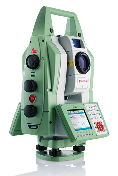
At a media event held during the HXGN Live Conference in Las Vegas today, Leica Geosystems introduced several new products. The highlight of the event was presentation of Leica Nova and the Leica Nova MS50 MultiStation.
The Leica Nova measurement solution is designed to provide users with a complete and seamless workflow, Leica Geosystems said. It integrates advanced measurement technology, modern and intuitive field software, intelligent office software, and Leica’s services to give users the ability to make faster, smarter decisions, across a range of applications. The flagship of the new solution is the Leica Nova MS50 MultiStation, which combines scanning, total station, imaging and GNSS positioning in one instrument to deliver fast and reliable results.
Leica Nova uses advanced measuring technology that provides accuracy and quality, yet is easy to use for an unprecedented range of applications, Leica said. The Leica Nova solution covers the complete process from capturing and visualizing data, to creating intelligent deliverables that shape the world. Whether users measure objects on a construction site, quickly calculate volumes, monitor a dam or a bridge, capture an accident scene with digital imaging or scan a façade, Leica Nova integrates all these capabilities in one compact, flexible solution.
The Leica Nova MS50 MultiStation. Photo : Leica Nova
The Leica Nova MS50MultiStation combines every significant measuring technology in one device for the first time, Leica said. Precision 3D scanning, extensive and precise total station capabilities, digital imagery and GNSS connectivity are brought together in the multistation. The new mergeTEC technology fuses hardware capabilities with comprehensive data-management solutions. Images are synchronized with scans, and scans are tied into total station measurements, making it easy to manage complex 3D data, Leica said.
The Leica Nova MS50 integrates 3D point cloud measurements into regular survey workflows. Users can collect and visualize their topographic survey data with detailed high-precision scans. They save time by computing results and verifying the integrity and completeness of data immediately in the field, avoiding costly reworking or returns. Ultimately, users benefit from better decisions with richer and more detailed data.
Also part of the innovative new Leica Nova solution are the Leica Nova TS50 high-precision total station and Nova TM50 monitoring station.
The Leica Nova TS50 high-precision total station has 0.5-inch angular accuracy and an optimum combination of angle and distance measuring. Integrated overview and telescope cameras with fatigue-reducing autofocus document the scene with high-quality photogrammetric images using the latest SmartWorx on-board software.
The Leica Nova MS50. Photo : Leica Nova
The user sees on the remote control display exactly what the Leica Nova TS50 sees, allowing for easy one-person data capture. The Leica Nova TS50 allows full control through “tap and turn” without the need to go to the instrument and back again. The 20-Hz live video stream can be combined with a graphical overlay for cost-effective recording with immediate clarification of ambiguous situations. Together with the benefits of GNSS connectivity, the Leica Nova TS50 offers complete versatility by delivering reliable results, Leica said.
For critical monitoring tasks, the new Leica Nova TM50 monitoring station provides the highest angle accuracy and offers short measurement cycles through high speed Piezo drives and a fast, highly accurate EDM. The Leica Nova TM50 includes 0.5″ angular accuracy and can measure up to 3’000 meters, which makes it the ideal sensor for monitoring tasks in mines, landslides, etc. For additional documentation, the monitoring sensor includes an overview camera and a telescope camera with 30x magnification and autofocus. The Leica Nova TM50 meets the challenge of 24-hour-a-day, 7-days-a-week monitoring applications. The Leica Nova TS50/TM50 instruments are IP65 rated and designed to withstand the roughest use in the most severe environments.
Leica GeoMoS 6.0 enhances conventional monitoring methods with automatic scanning of surfaces with the Leica Nova MS50 MultiStation. Photo : Leica Nova
The Leica software portfolio includes the following:
With the new Leica Infinity software, users can seamlessly manage, visualize, process and georeference combined total station, imaging and scanning data from the Leica Nova MS50 MultiStation and other Leica Geosystems sensors.
For AutoCAD users who have never before worked with rich point clouds or 3D datasets, the new Leica MultiWorx for AutoCAD plug-in software offers a simple way to integrate point cloud processing into existing workflows.
Nexteq Navigation has launched accelGRx, a platform for accelerating professional-grade GNSS receiver development. The platform provides open and production-ready hardware and software building blocks for GNSS receivers. accelGRx is designed for organizations looking to research and develop new techniques and algorithms requiring deep in-receiver integreation or quickly produce a small, high-performance receiver.
accelGRx supports GPS L1 and Beidou B1, and the hardware is GLONASS and Galileo ready. It pairs a compact form factor and industry standard pin layout with a code and phase precision of 4 cm and 0.4 mm respectively for both GPS L1 and Beidou B1. It incorporates an array of software development tools, including the ability to record and play back digitized signals.
An accelGRx licensee wil have tools to develop and test new deep in-receiver integration techniques and algorithms:
• Access to all source code, logic and tools
• Deep in-receiver access to real-time GNSS information
• PC-based software model of receiver platform
• Store and playback of digitized signals for development and testing
• Testing with production-ready receiver and real-world conditions
An accelGRx licensee will have the necessary assets and tools to begin commercialization immediately after development is complete:
• Hardware design (schematic, PCB layout, and BOM)
• FPGA logic design
• Full tracking and PVT source code
• Receiver operating system
• Design documentation and manuals
Nexteq also released two other products:
matrixRTK is a combination of the PPP and network RTK approaches to benefit network-RTK vendors. matrixRTK has the benefits of network RTK (fast initialization) with the benefit of PPP (no baseline restrictions).
L1-RTK-systems is a solution that allows our handheld users to use 2/L1 high sensitive GNSS handhelds working as base and rover to achieve 2-20 cm level accuracy. This is a reliable and cost-effective solution for field workers, Nexteq said.
C-Nav, supplier of international GNSS Precise Point Positioning services, has launched its latest GNSS real-time tide measurement package, C-Tides.
The C-Tides suite combines the vertical accuracy of C-Nav’s GNSS Precise Point Positioning service with the latest advanced ocean and coastal tides models, the company said.
C-Tides Online features real-time filters and vessel dynamics, a choice of worldwide Mean Sea Surface or regional reference frame models, and tidal prediction for mission planning.
C-Tides Offline utilities include data smoothing and outlier rejection, harmonic analysis, Doodson X0 filter, and a LAT option.
“It’s been a privilege working with our academic partners to develop what is probably the worlds’ most advanced real-time GNSS tide solution,” said Russell Morton, C-Nav head of development.
C-Tides is a fully supported C-Nav utility. The results are suitable for combining with other suitably calibrated vertical components to achieve IHO SP44 Order 1 or better.
F4Devices, a division of F4 Tech, is partnering with Laser Technology, Inc. (LTI). F4Devices will provide LTI with a custom version of its Flint handheld for use as a controller and data collector for its mobile GIS lasers as well as public safety divisions. This custom version of the Flint S-Series rugged handheld is available through the current LTI distribution channel. It will be branded under BAP Precision. BAP and F4Devices are strategic partners in rugged mobile computing development.
“We are excited and thankful for the opportunity to partner with LTI, a strong and respected leader in field laser data collection,” said Mark Milligan, president of F4 Tech. “The S-Series offers a cost effective solution that compliments the current product offerings.”
“Our product management team approached F4 Tech about a data collector solution, and they were quick to respond. The S-Series provides LTI with an ergonomic, rugged and reliable handheld unit for our Professional Measurement and Traffic Safety software solutions. We are excited to bring this solution to our customers,”said Derrick Reish, senior product manager of LTI.
RTKLIB, a developer of open source software for standard and precise GNSS positioning, has released its latest RTKLIB software (version 2.4.2), which fully supports NVS Technologies’ BINR proprietary binary protocol and the NV08C GNSS receiver series.
The use of RTKLIB, in conjunction with NVS Technologies’ NV08C GNSS receiver series, including the highly integrated NV08C-CSM surface mount module with geodetic grade raw data output, enables GNSS system designers and OEMs to develop highly accurate, low cost and compact precision-grade positioning and navigation equipment.
RTKLIB features include:
Full compatibility with NVS Technologies’ NV08C Series GNSS Receivers.
A portable program library and several APs.
Standard and precise positioning algorithms using GPS, GLONASS, Galileo, QZSS, BeiDou and SBAS.
Supports various GNSS based positioning modes, both for real-time and post-processing, including: Single, DGPS/DGNSS, Kinematic, Static, Moving-Baseline, Fixed, PPP-Kinematic, PPP-Static and PPP-Fixed.
Positioning mode for real‐time and post‐processing, including Single, SBAS, DGPS, RTK, Static, Moving‐base and PPP.
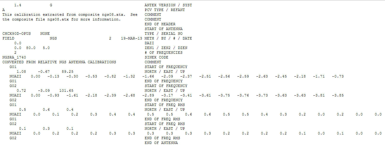
Supports many standard formats and protocols for GNSS, including RINEX 2 & 3, RTCM 2 & 3, BINEX, NTRIP 1.0, RTCA/DO-229C, NMEA 0183, SP3-c, ANTEX 1.4, IONEX 1.0, NGS PCV and EMS 2.0.
External communication via Serial, TCP/IP, NTRIP, local log file (record and playback) and FTP/HTTP (auto download).
Contact NVS Technologies for specific features compatibility. Visit www.rtklib.com for RTKLIB’s latest (ver. 2.4.2) software package download, release note, information, tutorial, manual and support.