Category: Survey

  • Test Results from Real-Time CORS Streaming, Space Weather and NDGPS

    Being a person who enjoys spending time in the field using RTK and DGPS, I followed up on my column last month, “Sources of Public, Real-time, High-Precision Corrections,” with a trip to the field to test the NGS CORS Streaming service. About a month ago, I made a trip to Colorado to attend the Space Weather Workshop in Boulder, stop by the SPAR conference in Colorado Springs, and visit with some of my colleagues in the Denver area.

    When I arrived in Denver, my plan was to meet Tim Smith (GPS Coordinator for the U.S. National Park Service) and travel to the Bakerville GPS test site in the Rocky Mountains, which was at about ~11,000 feet in elevation. My intent was to test the CORS Streaming and PBO real-time streaming that I discussed last month to better understand the accuracy and reliability of those services.

    I arrived at the Denver airport early on a Monday ready to rock and roll into the Rockies with some high-precision GNSS equipment. As it turned out, I was denied. In Colorado, the weather is dynamic. It was quickly degrading when I arrived in Denver. Snow was definitely in my future for the next few days. Tim made the decision that we shouldn’t travel to Bakerville. The reason for Tim’s trepidation wasn’t necessarily due to the weather in Bakerville, but rather that the I-70 Interstate might turn into a parking lot and we’d be stuck in traffic for a few hours. Fair enough. The backup plan was to do some local testing in the parking lot adjacent to Tim’s office in Denver.

    Tim invited Mel Philbrook to join us. Mel is a long-time GNSS technologist who works for the local Trimble dealer. He brought an SUV full of Trimble GNSS equipment, including one of the new R10 GNSS units as well as a GeoXH handheld with an external antenna.

    Mel also had an Intuicom RTK Bridge in the trunk of his SUV that facilitated the different sources of RTK reference data we could use. He could switch from CORS Streaming to the local VRS via NTRIP to UHF at the flip of a switch, sending corrections to both the R10 and the GeoXH. I was particularly interested in seeing how the units performed using CORS Streaming, which is/was a free RTK service (single baseline) that was in beta test phase. In Oregon, I don’t have access to CORS Streaming because the only CORS Streaming station west of the Mississippi River is in Boulder, Colorado. The station is TMGO (Table Mountain CORS).

    The baseline distance from TMGO to our location was about 55 km. The R10 was reporting a horizontal precision of about 4 cm. Not bad for a 55-km baseline. I didn’t compare the results to a survey mark (shame on me, but keep reading because I get to that) so I’m trusting the R10’s precision estimate. Tim said he’s run the test before using a GeoXH and a longer baseline and saw sub 10-cm horizontal precision. It’s not what the typical person using short baseline or RTK network is accustomed to, but for the high-precision GIS user who’s mapping utility, transportation, and infrastructure, that’s pretty darn good.

    Tim, Mel and I spent an hour or so messing around with the equipment before packing it up. Not a very scientific study, but it confirmed that CORS Streaming was accessible via NTRIP and reasonably accurate.

    In the meantime, the snow wasn’t letting up. This is the view as I was leaving Tim’s office to head to Boulder for the Space Weather Workshop:

    I wasn’t finished with my CORS Streaming testing yet. My experience at Tim’s office gave me enough confidence to allocate time later in the week to conduct a more detailed test after the Space Weather Workshop. Hopefully, the weather would cooperate (call me a fair-weather field guy).

    Space Weather Workshop

    Every April, NOAA’s Space Weather Prediction Center in Boulder hosts the Space Weather Workshop (SWW), a gathering that has evolved into the leading conference in the U.S. for space weather-related topics. It attracts attendees, experts and speakers from all over the world. The discussion isn’t centered on GNSS, but GNSS certainly is a topic that is discussed. This year’s central topic was the electric power grid. You can view the SWW program here.

    Believe it or not, this month (May 2013) was the predicted “solar maximum” for the current solar cycle (Solar Cycle 24, an 11-year cycle). However, Solar Cycle 24 has been unexpectedly weak. See the following slide presented by Doug Bisecker of the Space Weather Prediction Center. Doug is the Chairman of the Solar Cycle 24 Prediction Panel. His question, “Is there any chance we can still salvage some respectability?” speaks volumes about the difficulty in predicting space weather.

    ThePrediction
    Source: Doug Bisecker presentation at the 2013 Space Weather Workshop

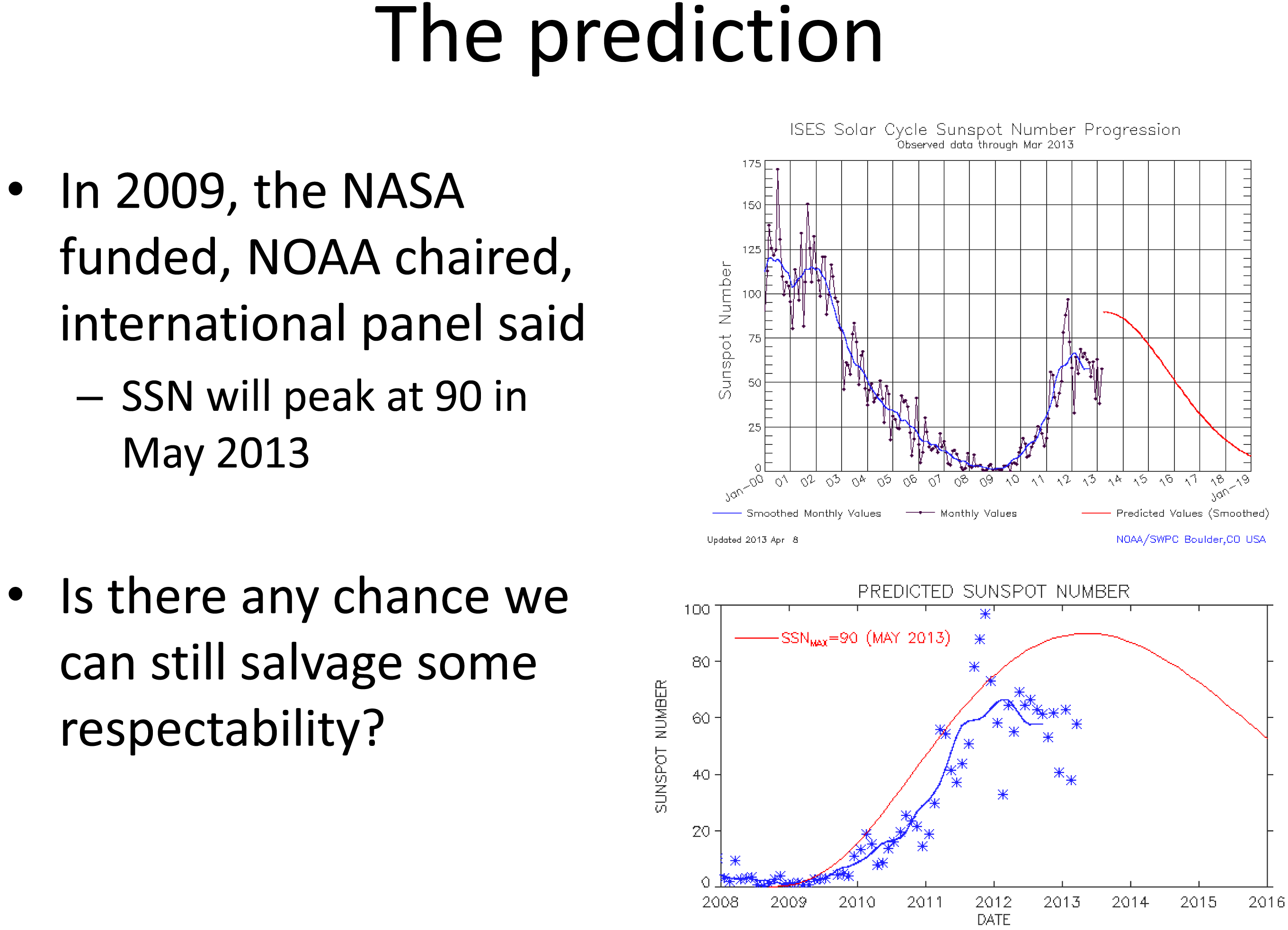
    From the above, you can see the actual number of sun spot occurrence has been significantly less than predicted. Although sun spots aren’t what cause GNSS receivers to have problems, sun spots can indicate the amount of solar activity, which can be related to geomagnetic storms. Geomagnetic storms disturb the ionosphere and are the events that cause the most problems for GNSS receivers. Looking at the top chart above, you can see the difference in activity between the last solar maximum (peaked in early 2002) and today. The difference is clearly significant.

    Does this mean we, the high-precision GNSS users, get a free pass on Solar Cycle 24?

    Not at all.

    Historically speaking, the most extreme geomagnetic storms (e.g., Oct/Nov 2002) have occurred after the solar maximum so our sensitivity to this issue should be keen for the next two years. Furthermore, there are orders of magnitude more high-precision GNSS receivers being used than ever before, and in mission-critical applications such as auto-steer in machine control (agriculture, construction, etc.). Most GNSS high-precision users today haven’t experienced the effects of an extreme geomagnetic storm. For a short primer on the effects of solar activity on GNSS/GPS, you might want to take a look at this article I wrote in 2008 as well Richard Langley’s 2011 Innovation column “GNSS and the Ionosphere.” In addition to the content, they both contain some valuable links to relevant articles.

    In line with a goal of the workshop, a panel of GNSS professionals looked at issues that users face as they go about their business at solar max. The panel was “Global Navigation Satellite System (GNSS) Services: Research Needed to Fill Operational Gaps.” Joe Kunches (SWPC) moderated the panel that included Dr. Geoff Crowley (Astra), Dr. Anthea Coster (MIT), Capt. Steven Miller (USAF) and myself. We highlighted precision GNSS, satellite navigation for commercial aviation (ADS-B), and current work to better understand the errors the ionosphere imposes on user activities.

    Something else I learned at the conference was how tough ionospheric scintillation is on GNSS receivers in Brazil. I feel for those users. When I mentioned I was traveling to Chile for an RTK project, the scientists said it is worse in Chile than the U.S., but still not as bad as Brazil. I’ll be very interested to experience how different it is than the U.S. (or other parts of the world where I’ve traveled).

    I keep a pretty close eye on space weather and in contact with NOAA’s Space Weather Prediction Center. When I hear of a space weather event that may affect high-precision GNSS/GPS receivers, I send out a Tweet with the hashtag #SolarActivity. You can follow me on Twitter at https://twitter.com/GPSGIS_Eric.

    From Space Weather Back to Local Weather

    As the week progressed during the Space Weather Workshop, the snow continued. Boulder looked like Christmas in April.

    I really wanted to spend some more time in the field to test the accuracy of the NGS’s CORS Streaming service and I was running out of time. In order to perform the test the way I wanted, I needed to find a local NGS survey mark that was observed using GPS. I checked out the NGS survey mark database and got lucky. There was one (PID = KK2060) located on a vista point parking area off of Highway 36 on the way from my hotel to the Space Weather Workshop. I couldn’t have asked for a better or more convenient survey mark location. I was planning to use a Bluetooth GNSS receiver so I could actually collect data while sitting in my car.

    On Thursday morning, Mother Nature cleared her skies for me so I drove to the vista point. Remember, there’s a couple of feet of snow on the ground, so I was really hoping to see some kind of wood lathe that would get me close to the survey mark (no, I didn’t preload the KK2060 coords in my GPS L). Fortunately, a wood stake was near the survey mark. However, I didn’t have a shovel or a metal detector so it was either using my hands to shovel and search under two feet of snow for the mark, or…thanks to the rental car company, the car came with a healthy-sized windshield scraper. After 15 minutes of digging in the snow with a windshield scraper, I found KK2060. I’m sure to the people parked on the vista enjoying the view; I looked very suspicious using a windshield scraper to dig a hole in the snow. I wouldn’t have been surprised if a state trooper had shown up.

    KK2060Hole
    KK2060 recovered from under two feet of snow with a windshield scraper.

    My final challenge was…no tripod or tribrach. I travel light and didn’t want to pack a set and, of course, I forgot to ask Tim if I could borrow a set. It’s never a good idea to set a GNSS antenna directly on the ground, but the antenna was small (<3” in diameter) and I did have a 5” diameter ground plane with about a 1” post. I was able to place it over the survey mark with reasonable confidence.

    As I mentioned before, I was using a Bluetooth GNSS receiver (GPS L1/L2, GLONASS), the SXBlue III GNSS.

    To collect the data, I was using an SXPad handheld with an AT&T SIM card for the Internet connection. For data-collection software, I used VisualGPSce, a free GPS data-collection program that collects and displays raw NMEA data. Although it doesn’t display enough digits of precision for the horizontal position, it accomplishes the simple task of collecting NMEA-formatted data without applying any transformation so I get the raw NMEA-formatted data from the receiver. It also displays some useful information such as PDOP, RTK indicator and elevation.

    The last piece of data-collection software I used was a free NTRIP client software written by the SXBlue people called SXBlue RTN. I needed an NTRIP client software to access the CORS Streaming mount point. The software manages the IP address, port and login/pwd of the CORS Streaming system.

    Logging into the NGS CORS Streaming site was painless, and within a few seconds I had an RTK FIXed position from the GNSS receiver, all from the comfort of my rental car, thanks to long-range Bluetooth. I collected ~45 minutes of NMEA data (1-Hz data rate) without interruption.

    When I returned to the office, I began the process of comparing the results from CORS Streaming to the NGS survey mark coordinate. I checked with NGS and they reported that CORS Streaming is referenced to the ITRF00 (epoch 1997.0) datum. The KK2060 coordinate is published in NAD83/2011 (epoch 2010.0). I needed to reconcile the datum difference before performing any analysis so I used the NGS HTDP (Horizontal Time Dependent Positioning) online tool to accomplish this.

    Finally, I used NMEA Analyzer (custom-built software for performing statistical analysis on GNSS NMEA data to NSSDA horizontal accuracy standards) to calculate accuracy (not precision) values of the data. I set up the NMEA Analyzer software to randomly select 200 epochs out of the ~2,700 collected to mitigate any bias due to filtering or other receiver “tricks”. Following are the horizontal results:

    HRMS Error: 0.0168m
    99%: 0.036m
    95%: 0.029m
    68%: 0.0189m
    50%: 0.014m

    Not bad for an antenna sitting on the ground and an 18-km baseline using a $6,000 GNSS receiver and a free RTK base station. Folks, this is the direction that GNSS technology is heading. The continued proliferation of high-precision GNSS infrastructure (RTK networks, real-time PPP, etc.) and the falling prices of RTK GNSS receivers will dramatically increase the availability of high-precision technology to those who previously could not afford to make the investment.

    I didn’t get a chance to test the PBO real-time streaming while I was in Colorado, but fortunately there are many PBO real-time stations that I can test from the comfort of my home office here in Oregon. In fact, there are so many in Oregon and Washington that I can test many different baseline distances to understand what accuracy users can expect. Look for my test results on that sometime this summer.

    National Geodetic Survey (NGS) Suffering

    Only a week after I did my field test of NGS’ CORS Streaming system in Colorado, NGS announced it was shutting down the CORS Streaming service effective April 26. On April 23, NGS issued the following notice by email:

    *********************************************

    The National Geodetic Survey’s prototype Real Time GNSS Data Service (Streaming CORS) will be discontinued effective April 26, 2013.  The prototype was introduced a few years ago as a small research project to gauge interest and usage as well as test a proof of concept with the RTCM communities.  However, due to low usage of this prototype service and staff limitations within the National Geodetic Survey, we have decided to discontinue the prototype. There were many contributing factors that lead to this decision but the following recent series of events has had a significant impact on project support and operations:

    — Funds were cut due to sequestration and rescission
    — Upcoming furloughs will impact all National Geodetic Survey Personnel
    — A NOAA-wide hiring freeze is in effect
    — Our only real-time expert will retire on April 30, 2013

    If you have any questions or comments to share, please contact Neil Weston at 301-713-3191 or by email – [email protected].

    *********************************************

    I think the action was premature. Hardly anyone knew about the CORS Streaming service and it was only deployed in a small number of locations, which was not enough to cover a significant geographic area or major metro areas.

    Nonetheless, I think this action points to bigger problems at the NGS. To all of us in the U.S. (and those in other countries), the NGS has been a tremendous source of GNSS technical expertise, products and services. The problem is that they are losing expertise at a faster rate than they are gaining. Just in the past few months, Dave Doyle and Bill Henning have both retired. Those two were a big part of the NGS user community outreach “boots on the ground” effort.

    Furthermore, as the notice indicates, NGS’s only “real-time expert” (Bill Henning) is now retired. That’s a problem. As real-time, high-precision GNSS is gaining traction quickly in industries beyond surveying and engineering, the resources for NGS to support this trend should also expand, not contract. On the other hand, the use of GNSS post-processing is not increasing, yet NGS has loads of resources allocated to support post-processing. As technology trends shift, resources need to be redistributed in alignment with those trends.

    The Future of NDGPS Open for Public Comment

    The U.S. NDGPS program is on the chopping block again. However, this time it’s much more serious. The last time this issue surface was in 2007 when funding for some of the NDGPS sites was being threatened. At that time, only some of the inland sites were facing decommissioning. The U.S. Coast Guard DGPS part of NDGPS was safe and funded.

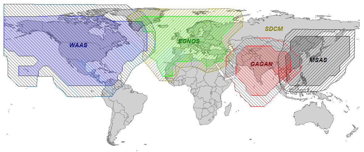
    However, that’s not the case this time. Even the U.S. Coast Guard is starting to question the value of the DGPS system it created and has been using for more than 15 years. The FAA’s WAAS (Wide Area Augmentation System) has proven to be a viable alternative to NDGPS and is used by thousands of sport mariners and commercial marine pilot associations across the U.S., as well as high-precision users in GIS and surveying/engineering. To further complicate the issue, the use of GLONASS is not supported by NDGPS. Like what we’ve seen in high-precision surveying/engineering receivers, GLONASS is becoming an important feature in receivers used by commercial mariners who have to deal with terrain and structures that impede satellite visibility. Even though WAAS doesn’t support GLONASS, some newer GNSS receivers are able to integrate GLONASS data into the WAAS solution, further increasing the value of WAAS over NDGPS.

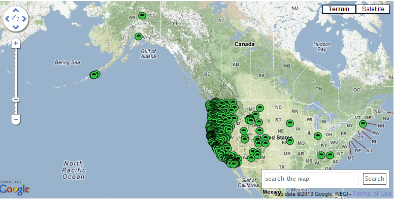
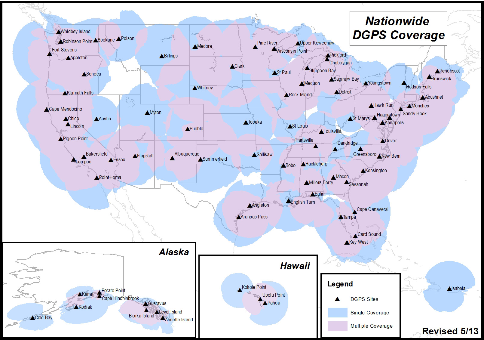
    It’s likely that you aren’t an NDGPS user, but you might still be affected if the NDGPS is decommissioned. There are a total of 86 NDGPS stations across the Continental U.S., Alaska and Hawaii. As well as being NDGPS signal broadcasters, they are also part of the NGS CORS program that is used by the NGS’s OPUS online post-processing service. If you are using OPUS or NGS CORS for post-processing, you might be using NDGPS CORS data and not realize it. Following is a map of all NDGPS stations in the U.S.:

    US_DGPS_Coverage_MAY13_Lg
    U.S. NDGPS coverage map.

    If you’re interested in reading an explanation from the U.S. Coast Guard and Department of Transportation about the request for public comment and submitting a comment, click here. To be considered, comments must be submitted by July 15.

    See you next month.

    Following me on Twitter@ https://twitter.com/GPSGIS_Eric

  • Trimble Adds Photogrammetry to Business Center Software for Surveyors

    Trimble has introduced a new version of its office surveying software — Trimble Business Center Software version 3.00. Trimble Business Center Software version 3.00 is a powerful, next-generation surveying office software suite designed to manage, analyze and process all field survey data, including optical, GNSS and imaging data.

    The new version features photogrammetry enhancements, including the ability to process images from the Gatewing X100 unmanned aerial system (UAS). These enhancements provide surveyors with increased visualization and processing capabilities, allowing them to further maximize productivity and create aerial survey deliverables.

    “Powerful and intuitive, Trimble Business Center and its integration with UAS data introduces new capabilities to surveyors and represents a significant leap in efficiency. Surveyors, engineers and geospatial data managers can increase their productivity, efficiency and quality of deliverables through the software’s aerial data processing capabilities,” said Erik Arvesen, vice president of Trimble’s Survey Division. “Traditional sites, such as large mines, that in the past have taken days to map using conventional methods can now be accurately modeled in just hours.”

    Version 3.00 introduces a new photogrammetry module for importing and working with flight data and images collected from the Gatewing X100 UAS and optical instruments, such as the Trimble S8 with Trimble VISION technology, which integrates calibrated digital cameras to collect survey data, stream video from the perspective of the instrument and capture panoramic still images. Based on software from Inpho, the Trimble Business Center photogrammetry module also provides office surveyors with the capability to process complete mapping projects containing aerial data, GNSS and total station observations. Surveyors can produce deliverables, including georeferenced orthophotos, 3D point clouds and digital surface models directly from Trimble Business Center.

    With the ability to integrate photogrammetry with data collected from GNSS receivers, total stations, and digital levels, surveyors can combine aerial images with GNSS measurements on ground control points and 3D laser scans of buildings to precisely, comprehensively and efficiently map large and complex sites.

    The new version also introduces 64-bit processing. As a 64-bit application, Trimble Business Center allows surveyors in the office to utilize their computer’s RAM, maximizing the productivity of the surveyor’s workstation, to display large images and point clouds for increased visualization functionality. Users can also display large images seamlessly; images “tile” automatically on import and the displayed resolution adjusts seamlessly as users zoom in and out for superior image viewing.

    “Inpho is a proven leader in digital aerial photogrammetry,” said Arvesen. “Trimble has taken that expertise and applied it to the survey market, as we pioneer the development of UAS data integration for surveyors.”

  • ComNav Offers GPS+BeiDou Board

    The K501 GNSS OEM board by ComNav is a GPS+BeiDou small-sized OEM board. K501 has advanced dynamic acquisition ability and high-accuracy carrier phase calculating. By using the GPS+BeiDou dual system high-dynamic processing engine, work in difficult environments is easier and RTK positioning accuracy can reach the centimeter level. The hardware size, interface, and data command are compatible with major brand OEM boards.

    201342815202868161
    The K501 GNSS OEM board by ComNav

    Features include:

    • GPS L1/L2+BeiDou B1/B2 dual satellite system calculating
    • Configurable GPS/BeiDou single-system positioning and GPS+BeiDou dual-system positioning
    • Compatible with other major brands on physical size, interface and data command
    • Directly export PJK coordinate
    • Supports short, middle and long baseline, RTK working distance can reach 50 KM
    • Easy to customize, can satisfy different kinds of demands
    • Built-in 100M internal memory
  • Surveyors Invited to ‘Survey Earth in a Day’

    sealOn the day of the solstice, June 21, geospatial professionals around the world and members of Land Surveyors United (a global support network for land surveyors) will be simultaneously recording survey grade GPS data from thousands of points around the globe, in order to gain a more accurate understanding of the earth’s surface.

    This will be the second Survey Earth in a Day event; in 2012 the first Survey Earth event was held, establishing many new understandings between geospatial and geomatics professionals and the general public on geospatial issues, organizers said. “With a mission not only to learn more about the Earth’s surface but also monitor its changes over time, and the changes in public perspective, as a global community, we may be more capable of assessing our future,” organizers said.

    “Our results will change the knowledge we currently have of the shape of the earth and thus provide new information about our planet’s surface for the benefit of all man-kind. Help the surveying industry and the surveyors in your region of the world by representing your area as we re-measure the entire globe in one single day,” organizers said.

    “If you are a geospatial professional with access to survey grade GPS equipment, you should consider helping us set a world’s record, right from where you live and work. Only a surveyor can provide the kind of precision that will be needed to truly understand the shape of planet earth. Just imagine how much this can help our industry,” organizers said.

  • NVS Technologies Releases Firmware Update for NV08C Receivers

    NVS Technologies has released updated firmware for its NV08C receiver series. Firmware v0206 is compatible with current and preceding hardware revisions of the NV08C receiver series. Firmware v0206 can be downloaded free of charge.

    Firmware v0206 offers:

    • Stabilized raw data output for output rates up to 10 Hz
    • Extended $POUTC NMEA message, including current LEAP SECONDS value, flags for expected UTC correction, and PPS edge shift relative to UTC (sawtooth correction SW).
    • Stabilized sleep mode operation ($POPWR,1111*66) for all NV08C series HW versions
    • Increased position accuracy and stability in urban canyon conditions with poor SV visibility
    • Cold start initialized to LEAP SECOND 16 (LEAP SECOND 16 came into effect July 1, 2012)

    Benefits include:

    • Obtain initial receiver coordinates more quickly, in cold starts, low satellite signal (foliage/canopy) and loss of satellite signal conditions (indoor, garages, tunnels…).
    • Greater satellite tracking reliability in poor visibility conditions (urban canyon/tall buildings, bridges/underpasses…).
    • Stable raw data output up to 10Hz rate.
    • Full sleep mode support for effective power savings.
    • Complies with ERA-GLONASS requirements.
  • GeoGathering 2013: Have You Developed Your Geospatial Data Strategy?

    GeoGathering logo NO_YEARThe conference GeoGathering: GIS for Gathering and Production Lines will be held Colorado Springs at the Cheyenne Mountain Resort on August 21-22, 2013. With the theme of “Developing a Data Strategy: Data Collection and Sharing,” the conference focuses on how operators collect and share information about their assets to increase operational safety and improve pipeline decision-making.

    “Today, acquisitions and fast growth in the gathering industry are forcing operators to develop a data strategy and look deeper at all aspects of their pipeline asset data – from how it is collected, to making it available to decision makers,” said Victoria Skogman, is the conference manager. “Currently, gathering systems are unregulated, but trends in the industry show this is likely to change in the future. Preparing for this impending change is crucial, hence the theme of the conference.”

    The goal of the GeoGathering Conference is to provide valuable information to gathering system and upstream operators who want to create efficient, accurate, and collaborative data strategies that work for their organizations. Presenters will demonstrate how GIS technology allows attendees to collect and share data between the field and the office, enabling their organization to make well-informed decisions. The versatile agenda focuses on real-world experiences — everything from integrity management and data requirements to data security and making GIS technology more accessible to stakeholders, Skogman said.

    The GeoGathering Conference committee estimates that close to 150 GIS professionals and top-level management from leading oil and gas companies will attend this year. Attendees will be able to attend sessions that include:

    • Developing a Data Strategy
    • Data Collection Methods to Meet Requirements
    • Data Security and the Cloud
    • Data Sharing: GIS as an Enterprise
    • Organizing Data for Decision-Makers
    • PHMSA MAOP Strategies
    • Web-enabled Data Sharing Technologies & Portals
    • Collecting & Sharing Data to Enhance Safety

    This year, attendees will experience the new, audience-focused format that offers two simultaneous tracks giving attendees the chance to tailor their own conference schedule. Plus, two of the biggest improvements are the addition of “structured networking” sessions and a “GIS Think Tank.”

    Structured Networking facilitates a small group setting, in which attendees have the opportunity to meet people with common interests, share practical ideas, and network with individuals who might possibly help your organization. When attendees leave the networking session, they will have a solid list of new business contacts, Skogman said. The networking sessions are strategically placed at the beginning of the conference to help you build new relationships over the duration of the conference.

    The GIS Think Tank session is also a unique addition to the agenda. It will feature five to seven GIS managers from a variety of gathering operators around the country. This is not a typical Q&A panel session; instead, it will allow the participating GIS managers to converse among themselves as the audience listens in. This will be mostly an unstructured session so that managers can spend more or less time on topics as they choose, Skogman said. It will be facilitated with questions from the audience. The purpose is to lead an informal discussion on some of the successes that each manager has had along with their opinions on pressing issues that gathering operators are facing.

    This year’s conference has a seven-person steering committee with pipeline gathering background. Members include Trisha Menasco of DCP Midstream, Tom Coolidge of Esri, Ellen Nodwell of Hess, Cameron Collins of Williams, Rob McElroy of McElroy Consulting, Ron Brush of New Century Software and Victoria Skogman of New Century Software.

    “The conference topics are very timely,” said Menasco. “Just when I thought I had all the data requirements figured out, it feels like we are starting over. I look forward to helping build an agenda that will be useful to the gathering community.”

    Early bird registration is open. The conference committee welcomes senior management, project managers, integrity management specialists, GIS professionals, field operations managers, regulatory compliance personnel, and engineers.

  • Applanix Introduces POSPac MMS v6.2 Software for Mobile Mapping

    Applanix has introduced POSPac MMS v6.2, its latest generation of software for directly georeferencing mobile mapping sensors using GNSS and inertial technology. Featuring new Applanix IN-Fusion Multi-Single-Base Processing, POSPac MMS V6.2 is designed to improve the productivity and accuracy of mapping from mobile platforms in the air, on land or at sea, the company said.

    IN-Fusion Multi-Single-Base Processing is designed for customers who need the highest level of differential GNSS position accuracy and perform long, linear projects such as power-line corridors, long highways or stretches of coastline. During these projects, a GNSS base station network may not be available, or the geometry of the network so weak that an Applanix SmartBase solution — which uses existing reference stations to achieve high accuracy over longer distances — is not viable. In these cases, IN-Fusion Multi-Single-Base Processing allows base stations to be established along the full length of the travel path and makes optimal use of the nearest base station at all times.

    Customers can now take advantage of robust tightly coupled in-fusion processing without the need to break the project up into multiple segments for each base station to attain the highest accuracy, Applanix said.

    “In addition to IN-Fusion Multi-Single-Base Processing, POSPac MMS V6.2 includes new features designed to increase productivity, efficiency and ease-of-use.  The Coordinate Conversion tool included allows users to choose from a number of local reference frames for inputting base station coordinates,” said Edith Roy, Development Manager of POSPac MMS at Applanix.  “POSPac MMS Version 6.2 demonstrates our commitment to providing customers with not only the most advanced software solutions for mobile mapping applications, but also the easiest to use.”

    POSPac MMS V6.2 can be purchased through Applanix’ global sales network. The software is available as an upgrade to all POSPac users currently under a maintenance contract.

  • Trimble Offers Improved Version of RealWorks Software

    Trimble RealWorks version 8.0 software will include a new 3D database engine, automated targetless registration and Web viewing capability incorporating RealWorks’ Scan Explorer interface. The new version is due to be released in June.

    The new enhancements will allow surveyors, contractors, engineers and geospatial professionals to rapidly process 3D laser scanning data and expedite the creation of deliverables for their clients, increasing productivity and reducing costs, Trimble said.

    The new 3D database engine in Trimble RealWorks version 8.0 will allow up to five times more data to be visualized and managed, compared to Trimble RealWorks version 7.2. The ability to handle larger data sets greatly increases usability and productivity for customers capturing data with 3D laser scanners such as the Trimble TX5 and Trimble FX.

    The automated targetless registration function, together with additional workflow enhancements, will provide further productivity gains for customers. The automated targetless registration function automatically identifies planar objects in each scan and matches the planes from multiple stations, creating a combined data set. The function enhances productivity in the field by eliminating target placement prior to data capture in applicable environments. Office processing time is also reduced by the fully automated function.

    Sharing of data with clients has been enhanced by the addition of a Publisher function within the Trimble RealWorks software that allows projects to be custom packaged for viewing via Microsoft Internet Explorer. The Scan Explorer interface, embedded inside a HTML web page, allows clients to navigate and explore the scan data as well as take measurements and add notes.

    “Software is an integral part of Trimble’s 3D laser scanning solutions and is essential to extract information from 3D data captured in the field,” said Tim Lemmon, marketing director of Trimble. “The new version of Trimble RealWorks software significantly improves our customers’ productivity in processing field data, extracting information and preparing deliverables for their clients.”

    The announcement was made today at SPAR International 2013, the leading conference for 3D data capture, processing and delivery technologies.

  • Comments Sought on Future User Needs for Nationwide DGPS

    The U.S. Department of Transportation’s Research and Innovative Technology Administration (RITA), in partnership with the U.S. Coast Guard, is seeking public comments on  current and future user needs for the Nationwide Differential Global Positioning System (NDGPS).

    The agencies want to know how users use NDGPS, and are seeking ideas for future uses or alternative uses.

    According to the notice in the Federal Register,”The NDGPS was designed to broadcast signals to improve the accuracy and integrity of the Global Positioning System (GPS) derived positions for surface transportation, as well as other civil, commercial, scientific, and homeland security applications. This analysis will be used to support future NDGPS investment decisions by the Department of Homeland Security and the Department of Transportation beyond fiscal year 2016. This notice seeks comments from federal, state, and local agencies, as well as other interested members of the public regarding current and future usage of the NDGPS, the need to retain the NDGPS, the impact if NDGPS signals were not available, alternatives to the NDGPS, and alternative uses for the existing NDGPS infrastructure.”

    NDGPS is a ground-based augmentation system that provides increased accuracy and integrity of GPS information to users on U.S. land and waterways. The system consists of the Maritime Differential GPS System operated by the U.S. Coast Guard and an inland component funded by the Department of Transportation. NDGPS is built to international standards, and similar systems have been implemented by 50 countries around the world. Modernization efforts include the High Accuracy NDGPS (HA-NDGPS) system, currently under development, to enhance the performance and provide 10-15 centimeter accuracy with integrity throughout the coverage area. For more information about NDGPS, visit the following webpages:

    Comments and related material must reach the Docket Management Facility on or before July 15, 2013.

    Comments can be submitted identified by docket number USCG-2013-0054 or RITA-2013-0001 using any one of the following methods:

    1. Federal eRulemaking Portal: http://www.regulations.gov.
    2. Fax: 202-493-2251.
    3. Mail: Docket Management Facility (M-30), U.S. Department of Transportation, West Building Ground Floor, Room W12-140, 1200 New Jersey Avenue SE., Washington, D.C.   20590-0001
    4. Hand delivery: Same as mail address above, between 9 a.m. and 5 p.m., Monday through Friday, except Federal holidays. The telephone number is 202-366-9329.

    All comments received will be posted, without change, to http://www.regulations.gov and will include any personal information provided.

    For more details on submitting comments, see the Federal Register notice.

    More information on the status of the NDGPS can be found on the RITA site and the U.S. Coast Guard site. More information on the HA-NDGPS is at the U.S. Department of Transportation site.

  • Topcon Web Portal Provides Real-Time Job Site Management Tool

    Topcon Positioning Group has launched a new web portal—Sitelink3D.net—designed specifically for general construction and engineering companies.

    In its announcement at the Munich construction trade show Bauma 2013, Topcon focused on the website’s features, which include giving end-users an intuitive way to manage and control every aspect of Topcon 3D machine control systems anywhere in the world.

    The subscription web-based service—accessed via computer, tablet or smartphone—is a user-friendly, real-time visualization and communications tool that allows users to access job site status and create new or update job site parameters, and view movement of machines on the job, Topcon said.

    Features of Sitelink3D include file transfers, messaging, machine tracking, remote support and training, real-time cut/fill mapping, and acquiring and storing real-time survey data.

    “While Sitelink3D is a complete site communications systems providing data control, machine tracking and a reporting system in one solution, Sitelink3D.net gives complete site management power in real time and provides remote information access to and from any piece of enabled equipment regardless of location,” said Richard Jackson, vice president of machine control applications.

    “The web portal provides simple, effective tools for monitoring machine efficiencies and site progress,” Jackson said. Through Sitelink3D.net, “companies can now better manage onsite progress, maintain data integrity, optimize production and minimize downtime. The ability to be able to send and receive job data and make instantaneous decisions or corrections saves time, fuel and money.”

    Most machines currently equipped with a Topcon 3D-MC system can be included in the Sitelink3D network by adding the SL-100 radio modem. New Topcon 3D-MC systems can be ordered with the modem pre-installed. Users of Topcon Pocket3D and 3D Office software can also be included in the Sitelink3D network.

  • Sources of Public, Real-Time, High-Precision Corrections

    I probably reminisce a bit too much at times, but I can’t help but think back to the ’90s, when obtaining three-meter accuracy via post-processing took a bit of planning. You either had to operate your own GPS base station, or you had to find a publicly available one before you went to the field to make sure you had a source of base station data. Remember, back then publicly available CORS weren’t very common.

    Then, towards the late ’90s, there were enough publicly available GPS CORS in the U.S. that you could collect data in the field without knowing where the closest base station was located, but you knew GPS base stations were so prolific that you could find one close enough to use for post-processing without prior planning/coordinating.

    Then, sources of real-time GPS corrections started through the same progression. In the ’90s, if you wanted real-time corrections, you either had to operate your own GPS base station and wireless datalink or, if you were lucky you were close to a U.S. Coast Guard beacon transmitter, which were few a far between. OmniSTAR was an option, but subscription was a quite a bit more expensive back then and the equipment was bulky.

    Today, post-processing is a no brainer. You don’t even need to have to license post-processing software. Through the National Geodetic Survey’s OPUS, Austraila’s AUSPOS and Canada’s CSRS-PPP, you can collect GPS data anywhere in the world, submit it to one of these free, online processing centers, and have the answer in your email inbox in a few minutes. But, as I’ve lamented more than once over the years, post-processing is a dinosaur. Mind you, it will never go away completely, but it doesn’t belong in the typical mainstream data collection workflow. It just doesn’t make sense.

    As it was 20 years ago and as it is today, the challenge with real-time GPS/GNSS data collection is the wireless datalink. If you’ve ever worked with real-time GPS/GNSS data collection and had a unreliable wireless data link between the base and your receiver, you know what I mean. It’s exceedingly frustrating and unproductive. However, when everything is working as designed, the real-time GPS/GNSS data collection workflow is a thing of beauty.

    Sources of high-precision real-time GPS/GNSS corrections are still a rather disparate group of public and commercial services that depend heavily on geography and communications infrastructure. For example, in the U.S. there is plenty of wireless coverage (GSM, CDMA, Wi-Fi) in metro areas and along major interstate roads, but there are still vast areas of rural farmland, prairie and desert where wireless networks don’t reach, leaving the choice of either satellite-based communications or setting up your own private wireless communications (UHF/VHF/900 MHz) between a base station and your receiver.

    That said, there are more choices for real-time, high-precision GPS/GNSS corrections than ever before. In fact, just last week, the International GNSS Service (IGS) announced that it has started to offer a global real-time PPP data stream for high-precision, dual-frequency GPS receivers via NTRIP. That means anyone with a dual-frequency GPS receiver and an Internet connection can achieve sub-decimeter accuracy anywhere in the world, free of charge. How exciting is that! I think about the regions of the world like South America, Central and Southern Africa, Australia, and parts of Asia that aren’t served well by public SBAS or other free sources of high-precision GPS/GNSS corrections. This service will open up those regions to a new level of real-time, high-precision positioning. There’s one catch though; GPS/GNSS receiver designers have to implement special firmware to use the IGS RT PPP service. Some manufacturers are talking about implementing this, which would be a boon for the high-precision GNSS user community. Global IGS RT accuracy = ~10 cm.

    Of course, OmniSTAR, Fugro, Starfire, Veripos have been providing real-time PPP for years  (as well as Terrastar and Trimble more recently) in their respective vertical markets (land and offshore) but it requires an annual subscription fee and specialty hardware (L-band) to receive the signal. The receiver hardware can be prohibitively expensive for some potential users, and their coverage, based on leased communications satellite footprint, isn’t dependent on local Internet connectivity. However, I will say that OmniSTAR subscription pricing is very competitive now, and that a public service like what IGS is offering has no guarantees of availability or accuracy. On the other hand, since commercial services like OmniSTAR are collecting a fee, they have an obligation to service their users. Nevertheless, public, sub-meter SBAS services like WAAS, EGNOS, MSAS, GAGAN, and SDCM are offered to non-aviation users on the same terms as IGS, and those services have worked out very well for our surveying and mapping user community.

    Other public sources of high-precision GPS/GNSS corrections are on the rise:

    RTK Networks. RTK networks continue to proliferate. In the U.S., many states offer free access to their centimeter-level statewide RTK networks. These are somewhat well-known within the surveying and agriculture community, but not as well known within the GIS community. Many countries also offer regional and country-wide RTK networks. RTK network accuracy = 1-2 cm.

    WSRNMap2011
    Washington State RTK Network
    Source: Washington State Reference Network. http://www.wsrn3.org/

    PBO real-time streaming. In the western U.S., UNAVCO’s Plate Boundary Observatory (PBO) maintains more than 1,000 GNSS base stations with many of them broadcasting RTCM3-formatted data. If you’re in California, Oregon, Washington, and the surrounding states, you should take a look at its website. The only requirement is that you have a receiver capable of handling RTCM3 data and you have Internet access in the field. You’ll also need an NTRIP client software (there are free ones available) running on your data collector (smartphone, handheld, tablet). Note that these are single baseline solutions (as opposed to the RTK network solution), so the further you are from the base station, the more error will be introduced. One caveat: be sure you understand which horizontal datum and epoch the particular PBO base station is streaming. PBO real-time streaming accuracy within 20 km = 1-2 cm.

    PBORealtime
    PBO Station Streaming Map
    Source: UNAVCO Plate Boundary Observatory. http://pbo.unavco.org/data/gps/realtime

    CORS Streaming. The National Geodetic Survey (NGS) is testing real-time streaming from nearly a couple of dozen CORS sites, mostly in the Eastern U.S. This is very similar to PBO real-time streaming. If you are 50-75 km from the base station, you’ll still be under 10 cm. If you’re within 20 km, you’ll be down to 1-2 cm.

    SBAS. SBAS (WAAS/EGNOS/MSAS/GAGAN/SDCM) was the first true source of public, country-wide high-precision GPS corrections. What make SBAS so easy is its ergonomics. It’s become such a standard that virtually every high-performance GPS/GNSS receiver designed today has SBAS capability built-in. You don’t need to purchase any extra hardware or software to use it. SBAS accuracy = sub-meter (with a receiver designed to optimize WAAS).

    SBAS_World_20121212_Extrapolated
    Global SBAS Coverage Map
    Source: Geneq, Inc. www.sxbluegps.com

    There’s no doubt that years from now, we’ll look back and be amused at how “difficult” and expensive real-time, high-precision positioning was. Today, there are many more sources of high-precision, real-time GPS/GNSS corrections than there were ten years ago. In ten years, there may or may not be many more choices for high-precision GPS/GNSS corrections, but certainly the sources will be less complex, more ubiquitous and more convenient than they are today.

    For the latest GPS/GNSS news, follow me on Twitter by clicking here.

    Thanks, and see you next month.

  • New Series of SPAN MEMS IMU Products Introduced by NovAtel

    New Series of SPAN MEMS IMU Products Introduced by NovAtel

    NovAtel Inc. has announced a new SPAN-IGM series of Micro Electromechanical Systems (MEMS) inertial sensor products, including the IMU-IGM-A1 MEMS enclosure and the SPAN-IGM-A1 GNSS/INS enclosure.

    The IMU-IGM-A1 is a small, rugged enclosure that houses a MEMS inertial sensor. The IMU-IGM-A1 can be configured from the factory as an integrated GNSS + Inertial Navigation System (INS) or as a standalone IMU sensor for pairing with a customer’s existing NovAtel SPAN enabled OEM6 receiver. Featuring regulated 10-30 VDC input and a dedicated wheel sensor input to enhance GNSS outage bridging capabilities, the IMU-IGM-A1 delivers a 200 hertz navigation solution and raw measurement output.

    “The IMU-IGM-A1 is the smallest, lightest IMU enclosure in our SPAN GNSS/INS product portfolio,” said Jason Hamilton, director of marketing for NovAtel. “It provides NovAtel customers with the ability to leverage our powerful SPAN technology in new applications that are size and weight constrained but still require highly precise position, velocity, roll, pitch, and heading.”

    The SPAN-IGM-A1 combines NovAtel’s OEM615 GNSS receiver card with a MEMS inertial sensor in a single enclosure. By integrating the MEMS IMU with NovAtel’s tightly coupled OEM6 GNSS/INS SPAN engine, advanced positioning options such as AdVance RTK, ALIGN heading technology and RAIM are available to maximize performance.

    Shipments of the new IMU-IGM-A1 enclosure and the SPAN-IGM-A1 GNSS/INS integrated enclosure commence early Q2 2013.