Category: Survey

  • ProStar and Bad Elf team up on global mapping tech

    ProStar and Bad Elf team up on global mapping tech

    ProStar’s PointMan software will now be bundled with Bad Elf’s high-precision GNSS receivers for worldwide sales. PointMan Precision Mapping provides a powerful cloud and mobile precision mapping solution to surveyors and geospatial intelligence systems (GIS) professionals.

    This strategic partnership expands the market reach of both companies and directly addresses the growing demand for a complete mapping solution in the utility and critical infrastructure industries.

    By combining Bad Elf’s advanced GNSS receivers with ProStar’s patented precision mapping solution, utility owners, contractors, municipalities and engineering firms are able to capture, record and visualize the precise location of critical infrastructure at a low cost and with a complete solution.

    Bad Elf delivers accurate, compact, lightweight and cost-effective GNSS solutions compatible with a broad range of third-party vendors. Together with PointMan, the bundled solution provides customers with a comprehensive, ready-to-deploy precision mapping solution designed to reduce costs, improve efficiency and accelerate industry adoption.

  • NV5 to deploy Hexagon’s Leica CoastalMapper bathymetric lidar system

    NV5 to deploy Hexagon’s Leica CoastalMapper bathymetric lidar system

    NV5, a division of Acuren Corporation, has become the first geospatial company to acquire and deploy Hexagon’s Leica CoastalMapper, an airborne bathymetric lidar system for coastal and riverine mapping.

    The CoastalMapper, developed by Leica Geosystems, combines a bathymetric lidar module with topographic lidar and an imaging sensor in a compact pod. The system collects bathymetric and topographic lidar data simultaneously with high-resolution imagery during a single flight. It captures up to 1 million bathymetric points per second and 2 million topographic points per second, producing imagery at a 5-centimeter ground sampling distance at standard flying altitudes.

    The system can operate at higher altitudes than previous generation systems, enabling surveys of steep mountainous river terrain. Applications include infrastructure resilience, flood monitoring and environmental investigations in shallow and deep waters.

    Kurt Allen, president of NV5’s Geospatial Business Unit, said the sensor system will allow the company to deliver more comprehensive datasets in coastal and riverine environments and support environmental resilience and infrastructure planning.

    NV5 Geospatial will receive the Leica CoastalMapper from Hexagon by the end of the year, with a handoff that took place at Intergeo in Frankfurt, Germany, Oct. 7-9, 2025.

  • UTTO partners wih GEODNET for utility mapping

    UTTO partners wih GEODNET for utility mapping

    GEODNET, a decentralized real-time kinematic (RTK) network with more than 20,000 active stations worldwide, is now partnering with UTTO, a leading innovator in underground utility mapping and digital damage prevention solutions.

    The partnership enables UTTO to leverage GEODNET’s global RTK correction services across its solutions, bringing enhanced centimeter-level accuracy to the utility locating and GIS industries.

    UTTO is known for pioneering products such as the vLocate Mapper, which integrates directly with GIS platforms like Esri’s ArcGIS Field Maps to streamline underground asset mapping and verification. By adopting GEODNET’s RTK correction services, UTTO customers gain access to reliable, triple-band GNSS corrections delivered through a uniform, global network. This ensures consistent accuracy across regions and significantly reduces the complexity traditionally associated with GNSS corrections.

    The collaboration provides UTTO users with seamless access to GEODNET’s correction services out of the box, eliminating the need for manual RTK configuration and reducing deployment friction for field teams. This simplifies the process of achieving centimeter-level accuracy in mapping underground infrastructure, while maintaining scalability for large utility operators and municipalities.

    Key benefits of the partnership include:

    • Turnkey RTK Access. UTTO devices now integrate directly with GEODNET corrections, requiring no manual RTK setup.
    • Global Coverage. GEODNET’s network of 20,000+ stations ensures consistent high-precision positioning across multiple regions.
    • Utility Mapping Optimization. Enhanced accuracy for locating underground assets, reducing strikes and improving field efficiency.
    • GIS Integration. Seamless compatibility with platforms such as Esri ArcGIS.
  • Orkid’s new VTOL drone integrates GNSS, lidar, photogrammetry and Starlink

    Orkid’s new VTOL drone integrates GNSS, lidar, photogrammetry and Starlink

    Drone-maker Orkid has unveiled a new variant of its Orkid 260 drone that incorporates four technologies to improve aerial data-capture technology.

    According to the company, the Orkid 260VTOL represents a leap forward in the integration of advanced sensing and communication technologies, setting a new benchmark for multi-mission drone capability across commercial and industrial applications. The company said it is the “first vertical take-off and landing (VTOL) drone to bring all four of the most advanced aerial data capture technologies together — onboard, fully integrated, and operating simultaneously.”

    The system combines lidar (YellowScan Surveyor Ultra), photogrammetry (Phase One P5 camera), GNSS/IMU (Trimble Applanix APX-RTX), and Starlink satellite communications integration in a single platform.

    Built on a 100% electric, NDAA-compliant architecture, the aircraft delivers an estimated 1.5 hours of flight endurance with a range of up to 75 miles. Designed for mapping, surveying, utilities, oil and gas, defense, and critical infrastructure inspection, the new model expands the operational scope for high-precision, long-range missions.

  • GEODNET launches survey-grade GNSS rover GEO-MEASURE

    GEODNET launches survey-grade GNSS rover GEO-MEASURE

    GEODNET, provider of a decentralized real-time kinematic (RTK) network, has launched GEO-MEASURE, a survey-grade GNSS rover that delivers centimeter-level accuracy at a consumer-accessible price.

    For decades, survey-grade GNSS rovers have been essential tools for precision applications, but high costs and complex configurations have limited access to survey-grade GNSS rovers to large firms and specialized professionals. GEO-MEASURE is an affordable fully equipped RTK rover integrating robust hardware, a dedicated mobile app, and a preloaded RTK corrections service into a single turnkey package.

    GEO-MEASURE is engineered for professional reliability with quad-frequency support across GPS, GLONASS, Galileo and BeiDou, Its 1,040 tracking channels provide resilience under canopy or in urban environments. Its rugged, waterproof housing is built for daily use, while a 24-hour rechargeable battery and USB-C charging make it as convenient as a consumer device while still delivering survey-grade performance.

    Available for both iOS and Android, a free companion app simplifies setup, the company said. Once paired via Bluetooth, users can:

    • visualize survey points on maps
    • capture field notes
    • manage multiple projects
    • export data in standard formats (CSV, KML, GPX, GeoJSON) for integration with GIS platforms, CAD workflows, or drone mission software.

    By making centimeter-level accuracy affordable, accessible and scalable, GEO-MEASURE opens professional-grade GNSS workflows to new audiences in construction, GIS, drone operations, agriculture and environmental monitoring.

  • Quectel launches LR700A smart connected GNSS receiver

    Quectel launches LR700A smart connected GNSS receiver

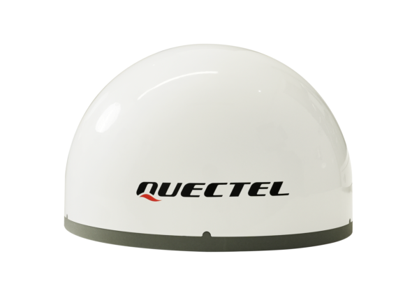
    Quectel Wireless Solutions has introduced the Quectel LR700A smart connected GNSS receiver, an all-in-one high performance quad band base station solution, capable of connecting to the cloud to deliver GNSS correction data, usable either standalone or within an RTK station network.

    Available for use globally, the modular design integrates the GNSS receiver with cellular, Wi-Fi and antenna systems, while providing extension slots for Zigbee short-range communication.

    Cellular connectivity makes the system highly versatile, enabling deployment anywhere without requiring existing infrastructure, ideal for establishing RTK correction services in remote locations. The integrated short-range communication capabilities make it ideal for pairing directly with nearby rovers, creating a complete RTK solution for localized high-precision applications.

    The quad-band GNSS receiver enables simultaneous reception of signals from GPS, Galileo, BDS, GLONASS, QZSS and NavIC constellations across the L1, L2, L5 and E6 frequency bands. The Quectel LR700A supports 1040 channels, enabling flexible data transmission and remote management with cellular, ethernet and Wi-Fi networks. Easy monitoring and configuration over local networks are ensured via an intuitive web-based interface.

    “This highly versatile product enables developers to specify an all-in-one, full-constellation receiver that supports multi-frequency tracking while offering ultra-low power consumption and a robust, industrial-grade design,” said Windy Fang, director, GNSS Product Line, Quectel Wireless Solutions. “Its power efficiency and integrated, compact design make it ideal for use cases where space and energy are constrained.”

    Designed to function as a base station, the Quectel LR700A delivers precise GNSS corrections and positioning for high accuracy applications including smart agriculture and precision farming use cases, surveying and mapping, autonomous vehicles and outdoor robotics, such as lawnmowers.

    The LR700A’s ultra-low power consumption makes it ideal for power constrained use cases with typical consumption of up to approximately 2.1W with ultra-wide range voltage support from 9-36V. The LR700A weighs 2.1kg, has a diameter of 220mm and height of 149mm and operates in the -40oC to +85oC temperature range. Support for local Wi-Fi web user interfaces and remote cloud configuration ensure simplified field installation.

    Featuring an IP67 rated, industrial-grade design, the LR700A is resistant to shock, impact, drop, lightning and ultra-violet light damage, ensuring reliable operation and long-term durability in outdoor conditions. Certifications for CE, FCC, RoHS and REACH compliance are in progress.

  • Topcon and Amberg launch integrated solutions for rail and tunnel at Intergeo

    Topcon and Amberg launch integrated solutions for rail and tunnel at Intergeo

    Topcon Positioning Systems and Amberg Technologies are entering into a collaboration agreement and launching fully integrated solutions for rail and tunnel applications. The interoperability of hardware and software platforms is designed to allow professionals to seamlessly combine technologies from both companies to enhance workflow efficiency and accuracy.

    The announcement was made at Intergeo 2025, held Oct. 7-9, in Frankfurt, Germany.

    At the show, Topcon also announced an expansion of its geomatics portfolio, featuring advancements in mass data software solutions central to a connected workflow ecosystem. The producs follow
    the announcement of the dedicated business structure focused on delivering high-precision technology, software, and services for geomatics.

    The agreement with Amberg Technologies comes at a time when increased urbanization is driving demand for new underground infrastructure and placing demands on aging and existing infrastructure. Digitalization and automation can help contractors and civil engineering firms address these critical industry challenges, as well as labor shortages, tight project schedules, and increasingly complex design requirements.

    Key capabilities resulting from this collaboration include the ability to utilize Topcon’s advanced positioning technology directly with Amberg’s rail and tunnel hardware and software platforms. This integration streamlines tasks such as track alignment, tunnel profiling, and volumetric analysis. The integrations address the need for technology systems that reduce data translation gaps between different hardware and software platforms, eliminating potential errors that can occur when transferring data between systems. 

    Geomatics products and services

    Foundational tools for Topcon’s connected workflow are Collage and ClearEdge software, which allow for data, feature extraction, and the seamless delivery of results into GIS, BIM or CAD environments. Topcon Collage, available in Site, Office and Web versions, serves as a central data hub, enhancing data sharing among all project stakeholders in both the field and office. Topcon is also introducing the Collage Cloud Connector for improved connectivity with Autodesk platforms and ClearEdge solutions such as EdgeWise or Verity.

    Featured hardware and software include:

    • CR-H1 handheld scanner: The CR-H1 handheld mapping solution utilizes iPhone Pro devices with integrated LiDAR that collects georeferenced images and employs photogrammetry to create detailed, full-color 3D point clouds. The iPhone connects to the Topcon HiPer CR receiver, enabling centimeter accuracy with RTK corrections from the Topnet Live GNSS corrections service. The receiver and iPhone are both mounted on a specialized handle, so users can easily capture point clouds while walking throughout the job site. The devices needed can quite simply be held in one hand for maximum mobility in the field.
    • CR-M1 scanner and new Onami software: The CR-M1 is an indoor/outdoor mapping system that can be utilized on a backpack or on a survey pole. The CR-M1 is ideal for urban and construction mapping, multi-floor buildings, real estate, underground mapping, mines and tunnels, stockpiles, and forestry environments. Publishing and sharing the CR-M1 data with Collage Web allows the user fast, web‑based visualization and manipulation of their 3D point clouds and meshes.
    • CR-P1 multi-functional 3D terrestrial laser scanner: The CR-P1 provides real-time, georeferenced point cloud generation on-site, equipping the user with actionable data that can be used for various applications. Enhancements to the Topcon Collage Site software solution provide new mass data workflow capabilities designed to allow for the real-time acquisition and processing of data more accurately, efficiently, and quickly to provide the user with greater productivity.
    • CR-S2 handheld scanner with Magnet Flow and Bridge software: The CR-S2 is a handheld scanning system that uses multiple localization fusion-SLAM to perform mapping projects in challenging environments. It is designed to work in construction and infrastructure applications as well as open, featureless environments such as beaches, coastlines, farmland, and airports. In open environments, the RTK connection to the Topnet Live network ensures position quality. Publishing and sharing the CR-S2 data into Collage Web allows the user fast, web-based 3D point cloud and mesh visualization with easy-to-use measurement and annotation tools.
    • LN-1000i Layout Navigator withTopcon Digital Layout software: The LN-1000i is an addition to the Layout Navigator series that includes new features, including reflectorless measurement capabilities, green laser beam pointer and an integrated camera for live view, camera control and enhanced prism lock. When combined with the new Topcon Digital Layout 2.0 software, this instrument is designed to set new standards in building construction.
    • Expanded Hybrid Positioning capabilities with Topcon software updates for Field – Office – Tools – Enterprise: Allows for better cooperation switching between GT robotic total stations and the HiPer XR GNSS receiver as an optical and GNSS hybrid solution. The new version 10 Topcon Field software enables the user to use the tilt of the IMU when measuring to the prism in Hybrid Positioning mode.
    • Collage Cloud Connector: New Windows app designed to simplify and automate the process of downloading and synchronizing project data from Collage Web to a local machine for use with Autodesk, ClearEdge3D software, or Collage Office.
  • Septentrio demos tracking of Xona’s first LEO PNT satellite

    Septentrio demos tracking of Xona’s first LEO PNT satellite

    Septentrio and xonaspace.com have signed a Memorandum of Understanding (MOU) to deepen their collaboration on next-generation positioning and timing solutions.

    The agreement builds on Xona’s recent successful launch of Pulsar-0, its first production class LEO PNT satellite. Within days of launch, Septentrio began tracking and analyzing Pulsar signals, an early milestone toward unlocking the service’s full potential.

    Together, the companies will continue joint testing and validation to prove Pulsar’s full capabilities, including:
    •    native centimeter-level accuracy
    •    100x stronger signal strength that reaches indoors and under dense foliage
    •    robust protection against jamming and spoofing.

    Through this partnership, Septentrio and Xona will advance receiver development, evaluate real-world performance, and explore commercial opportunities across diverse set of industrial and defense applications. Potential use cases span drones and autonomous vehicles, precision agriculture, construction and mining, robotics, timing and critical infrastructure.

    This collaboration marks a significant step toward addressing the growing demand for robust, high-precision navigation in challenging environments. The MOU underscores a shared vision of both companies to advance satellite-based navigation technology and unlock the potential of hybrid GNSS-LEO solutions.

  • Juniper partners with Point One for cm-level accuracy

    Juniper partners with Point One for cm-level accuracy

    Juniper Systems is partnering with Point One Navigation to enable Juniper’s Geode GNSS receivers to achieve seamless, centimeter-level accuracy through Point One’s Polaris RTK corrections network.

    The partnership will deliver integrated, field-ready computing and high-precision positioning solutions for demanding industries across the U.S., Europe and globally. By combining Juniper’s rugged mobile devices with Point One’s professionally managed Polaris RTK corrections network, users will benefit from unparalleled accuracy, increased field uptime, and reliable operation even in harsh conditions, the companies said.

    Point One’s Polaris RTK corrections network, with thousands of actively monitored base stations, provides critical positioning in applications such as environmental sciences, utilities, construction and geospatial mapping. When integrated with Juniper Systems’ Geode GNSS receivers, the result is a reliable solution for collecting highly accurate data in remote locations, the companies said.

    The partnership is already underway, with collaboration on new product packages, regional support, and joint outreach initiatives planned throughout 2025. Customers will benefit from coordinated service, expert guidance, and access to bundled solutions tailored to their operational needs.

  • Trimble launches POSPac complete post-processing software

    Trimble launches POSPac complete post-processing software

    Trimble as released its new post-processing software, Trimble Applanix POSPac Complete.

    The solution combines Trimble ProPoint positioning engine, post-processed Trimble CenterPoint RTX (POSPac PP-RTX) and Applanix IN-Fusion+ multi-sensor aided inertial engine. This integration offers geospatial professionals the ability to deliver accuracy and efficiency in the crewed and unmanned systems, land and marine mobile mapping and surveying industries.

    POSPac Complete will be showcased at INTERGEO 2025.

    A redesigned software solution embedded with POSPac PP-RTX, Applanix POSPac Complete is available exclusively as an all-in-one term license that bundles essential GNSS augmentation options — single base, Applanix SmartBase post-processed VRS and POSPac PP-RTX service — into a single, transparent annual fee. This eliminates hidden costs, simplifies budgeting and ensures access to software updates, while Trimble RTX removes the need for base stations and provides global coverage.

    Because Trimble RTX is embedded into the software, users around the world can attain seamless and efficient workflows with centimeter-level accuracy, even in remote or inaccessible areas, increasing productivity in their mapping process. Additional time savings are gained with the elimination of the time-consuming and challenging task of setting up and managing base stations that may be in different local datums or epochs.

    “The new POSPac Complete is more than just a software update; it’s a paradigm shift in how geospatial professionals achieve high-accuracy results because of Trimble’s unique RTX factor,” said Nico Jaeger, product manager at Trimble. “By integrating the power of PP-RTX directly into the software, we’ve eliminated the logistical headaches of base stations and streamlined the entire workflow, making mobile mapping more accessible than ever before. Altogether, it helps new and experienced users to produce survey-grade results with unprecedented speed and simplicity, truly representing the next generation of geospatial processing software.”

    Additional features in the new POSPac Complete include:

    • Modernized user interface: A new look and feel with a background map and a streamlined project wizard for easier and more efficient workflows, and a better user experience.
    • Trimble IonoGuard: Trimble’s latest technology that detects and mitigates the effects of ionospheric scintillation, which is especially important during the solar activity peaks, supported in single base and PP-RTX processing modes.

    Optional add-on features available for purchase:

    • Camera QC tools: The robust successor to CalQC, providing rapid IMU to camera boresight calibration for single-head and multi-head (oblique) camera constellations with minimal user interaction.
    • Lidar QC tools: Trimble’s leading software application for IMU to lidar boresight calibration and trajectory adjustment using SLAM techniques is now enhanced with support for automatic ground control point (GCP) detection, the RIEGL lidar native file format and reduced RAM requirements for faster processing.

    The POSPac Complete solution will be available in November 2025 through the Trimble sales channels. For more information or to request a demo, click here.

  • Teledyne Optech to showcase mapping and marine technologies at INTERGEO 2025

    Teledyne Optech to showcase mapping and marine technologies at INTERGEO 2025

    Teledyne Optech will showcase its portfolio of solutions designed for topographic and marine mapping and electric utility inspection at Intergeo 2025, taking place Oct. 7-9 in Frankfurt, Germany. The company will exhibit at Hall 12.0, Stand 0C067.

    Featured technologies will include Fathom, a topo-bathymetric airborne lidar system designed for data integration of topo lidar, bathy lidar and a multispectral camera capturing the coastal scene from dry land to below water. Also on display will be EchoONE, Optech’s smallest lidar sensor to date at just 1.65 kilograms, combining long-range performance with NDAA compliance and real-time generation of georeferenced point clouds. Visitors will also see Network Surveyor, powered by Galaxy Edge and designed to meet the time constraints of electric utilities, featuring real-time processing and a software analytics stack for utility operators.

    Visitors are invited to view a new compact lidar sensor designed for integration in modern wing and belly pods. Deployable in lightweight aircraft and helicopters, the sensor delivers high resolution for mapping projects, utility asset management and vegetation monitoring. Teledyne Optech will host a reception Tuesday, Oct. 7, from 4-6 p.m. at the stand.

    The booth will also showcase Teledyne Marine’s sonar and software solutions for marine infrastructure projects, including dredging, offshore wind and port and harbor operations. Live demonstrations of Teledyne FLIR IIS’ spherical imaging camera Ladybug 6, with spatial accuracy of plus or minus 2 millimeters at 10 meters distance, will be available.

    Mike Lee, director of product management at Teledyne FLIR IIS, will speak Tuesday, Oct. 7, from 12:50-1:10 p.m. on “Beyond Resolution: Advancing Mobile Mapping Through Spherical Imaging Innovation.”

    Teledyne Optech is a lidar solutions provider. With operations and staff worldwide, Teledyne Optech offers solutions for topographic and marine mapping, defense and electric utility inspection.

  • Topcon launches Geomatics division ahead of Intergeo

    Topcon launches Geomatics division ahead of Intergeo

    Topcon Positioning Systems has created of a dedicated business structure focused on delivering high-precision technology, software and services for geomatics. The new organization consolidates and expands Topcon’s portfolio of surveying, geospatial and GIS solutions, while opening new pathways into emerging markets.

    The specialized division is an addition to the company structure, which includes established divisions dedicated to construction and agriculture.

    “Geomatics is entering a new era,” said Ivan Di Federico, president and CEO of Topcon Positioning Systems. “It is no longer only about collecting points and producing maps. Today, it is about capturing massive amounts of geospatial data, connecting multiple data streams, and delivering insight with the speed and simplicity our customers demand. Topcon’s role is to reduce the gap between field capture and business decisions. By elevating geomatics into its own global business group, we are signaling that this discipline is vital — not just for traditional professionals, but for every sector where spatial intelligence drives efficiency and growth.”

    Photo:
    Neil Vancans will lead the new Geomatics Sales Unit of Topcon. (Photo: Topcon)

    Neil Vancans, an experienced leader in the surveying and geospatial industries, has joined the company as the head of its new Geomatics Sales Unit. He brings decades of experience in senior leadership roles at companies including Leica Geosystems, Thales Navigation, Septentrio, and Altus Positioning Systems.

    “Topcon has the precision technology, the global resources, and the vision to reshape what users can expect from geomatics,” Vancans said. “The demand for accurate, reliable positioning is expanding rapidly, and our goal is to turn raw data into usable, actionable intelligence. That means creating value for customers, empowering dealers and partners, and ensuring that geomatics solutions accelerate digital transformation.”

    Topcon geomatics solutions — including the expanding Capture Reality portfolio — will be showcased at Intergeo 2025 in Germany, Oct. 7-9.

    For more on Topcon’s focus on precision, watch the video “Since Precision Exists.”