Schweitzer Engineering Laboratories, Inc. (SEL) has added support for the Precision Time Protocol (PTP) to its SEL-2488 Satellite-Synchronized Network Clock. In a single clock, users can now synchronize end devices with sub-microsecond accuracy using demodulated IRIG-B and/or PTP. The SEL-2488 can meet all the timing needs of industrial and utility applications.
The SEL-2488 offers security features, including Satellite Signal Verification in which the clock uses two satellite constellations to validate time signals, providing a layer of protection from GPS spoofing attacks. For fault tolerance, customers can opt for a second, redundant hot-swappable power supply, which can be connected to a second power input source. If GPS is lost, the clock switches to a standard TCXO holdover with 36-microsecond-per-day accuracy or an optional OCXO holdover with 5 microsecond average accuracy. The clock operates over a wide temperature range of –40° to +85°C (–40° to +185°F) and is backed by SEL’s 10-year, no-questions-asked worldwide warranty.
In addition to providing IRIG-B and NTP outputs, the SEL-2488 can now serve as a PTP grandmaster clock, supporting both the default profile (IEEE 1588-2008) and the power system profile (IEEE C37.238). The SEL-2488 is capable of synchronizing time for up to four independent networks with a time-stamp accuracy of 100 nanoseconds. Existing users of the SEL-2488 can purchase this as a firmware upgrade.
“Now there’s a choice,” said Shankar Achanta, R&D manager for precise time and wireless networks at SEL. “You can use different timing protocols based on your infrastructure and application needs. The SEL-2488 is the one network clock that can meet all our customers’ timing needs.”
The SEL-2488 was first released in September 2014. SEL included several security features such as Syslog, the Ethernet standard for event messaging, which allows the SEL-2488 to integrate smoothly into a customer’s existing event system; role-based accounts and Lightweight Directory Access Protocol (LDAP) for user authentication; and a secure HTTPS web interface, which provides a graphical SkyView display for troubleshooting signal or antenna issues. The SEL-2488 also meets and exceeds IEEE 1613 Class 1, an electric transient and interference standard for communications products.
Designed, tested and manufactured in Pullman, Wash., a standard SEL-2488 configuration, including a dual-constellation, high-gain GNSS antenna, retails for $2,700. The PTP firmware upgrade option for existing users costs $1,750. To learn more about the PTP enhancement in the SEL-2488, visit www.selinc.com/p222.
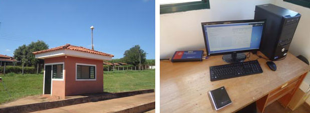
The monitoring station in Brazil uses a Septentrio PolaRxS receiver to monitor the ionosphere, a Septentrio AsteRx3 to perform tests static and kinematic tests, and three RTK Altus APS3 receivers (one as a base station and two as rovers.)
After 27 months of intensive research, a project team funded under the European Union’s 7th Framework Programme has come up with a solution to counter the problem of ionospheric disturbance affecting GNSS signals.
The CALIBRA project recently showcased a commercially applicable approach to mitigate the phenomenon’s impact on high-accuracy GNSS positioning techniques. In two demonstrations, the project’s newly developed algorithm was successfully tested in actual precision agriculture and offshore operations.
Solar flares can cause ionospheric disturbance, a sudden increase in radio-wave absorption that often delays the propagation of signals and ultimately affects positioning. The problem has kept researchers busy for years.
The CALIBRA project team has been participating in this global research effort by focusing on Brazil, which is one of the most exposed regions due to its proximity to the magnetic equator. Add to this that the sun is at its peak of activity since it entered its new 11-year cycle in 2010.
The project achieved three main milestones. First, the team confirmed that ionospheric scintillation and variations in total electron content (TEC) had a direct impact on the functioning of high accuracy GNSS techniques, such as Precise Point positioning (PPP) and real-time kinematic (RTK) positioning. Then a suitable metric was established to characterize these ionospheric disturbances. Finally, the project produced a short-term empirical model for forecasting TEC and scintillation. A regional TEC map was developed which proved advantageous for use in Brazil and, to counter scintillation, a number of approaches for the mitigation of this phenomenon were proposed and their benefit demonstrated.
The project exploited the CIGALA-CALIBRA network and database — a network of ionospheric scintillation monitor receivers with a web interface (the ISMR Query tool), which collects more than 10 million observations on GPS, GLONASS, Galileo, BeiDou and other global navigation systems every day. Since it was launched in December 2014, this data has helped assist users from more than 20 countries because of the software’s visualization and mining techniques.
In light of this success, CALIBRA partners INGV (Istitute Nazionale di Geofisica e Vulcanologia) filed a patent for their forecasting model, and a new spin-off company — SpacEarth Technology — was set up. SpacEarth’s main purpose is to secure the software’s commercialization in relevant applications and services, while also improving and adapting it to evolving market needs.
The project’s results promise to considerably reduce downtime and financial losses caused by ionospheric disturbance in Brazil and other regions of the world. Learn more about the project here.
With Exelis RangeVue, a high-performance GIS visualization engine provides real-time updates of critical operational elements.
Exelis has launched its first airspace situational awareness tool designed specifically for unmanned aerial system (UAS) operations in the United States. Symphony RangeVue puts real-time Federal Aviation Administration (FAA) surveillance data, flexible background maps and weather information in the hands of UAS operators and test range personnel. The system provides significant improvements to the safety and efficiency of UAS operations, whether on the test range or in the field.
Symphony RangeVue enables UAS operators and test range personnel to have access to both real-time and historical surveillance information via a web-hosted platform, helping to manage mission operations from multiple locations with full visibility of assets. Symphony RangeVue can be used as a command center decision-support and post-event analysis tool, or in the field as a sense-and-avoid addition to UAS ground control stations. Flexible geo-fencing tools alert operators when a UAS approaches airspace boundaries or when other aircraft are in the vicinity.
“For the first time, UAS operators and test range personnel will have the same situational awareness currently available to general aviation pilots through traffic information broadcast services. This capability is available without having to install avionics surveillance equipment on the UAS aircraft,” said Ed Sayadian, vice president of Civil and Aerospace Solutions for Exelis. “Leveraging the FAA’s own surveillance data combined with advanced sense-and-avoid alerting capabilities, Symphony RangeVue will significantly increase the safety of UAS operations.”
Symphony RangeVue combines a high-performance visualization engine with the vast network of Exelis NextGen surveillance data, including all of the FAA’s surveillance systems: automatic dependent surveillance-broadcast; en route radar; terminal radar; airport surface detection equipment-X; airport surface surveillance capability; and wide area multilateration. It also integrates locally deployed surveillance assets to deliver hyperlocal situational awareness.
GIS Cloud is previewing Maplim, an application that allows for fast, intuitive real-time collaboration on a map using any device. GIS Cloud is offering sign-ups for free, early access to Maplim.
According to GIS Cloud, “The idea is to put a map in the context of an organization board where you created projects and cards while engaging with your colleagues in discussions, making drawings (redlining and annotations), attaching documents, or just leaving comments.
Features:
Organization. Create real-time collaboration streams as cards, to which you can add any content around a map and share it with your colleagues. Maplim adapts to your project, team, and workflow.
Redline and Comment. Seamlessly make drawings on a map, add notes, marks, and comments, and provide your team with everything they need to get things done in real time.
Sharing. Attach and access important media such as photos, videos, PDFs, and Excel and Word documents relevant to a card.
Sync. Maplim stays perfectly in sync across all your devices, wherever you are. Post comments for instant feedback, follow your team’s activity in real time, and share results with anyone, anywhere, and on any device.
GIS Cloud is offering a free webinar on Maplim on April 28.
GIS Research Methods provides a solid introduction to research methods using GIS.
Scientific data that’s spatially analyzed produces highly useful information for academics, scientists and other researchers, helping them answer questions and make well-informed decisions, according to a new book published by Esri.
Authors Sheila Lakshmi Steinberg and Steven J. Steinberg explain how to incorporate spatial thinking and GIS into research design and analysis. The book introduces readers to the value of thinking spatially, GIS basics, research design and ethics, data sampling and collection, volunteered geographic information, spatial analysis with Esri ArcGIS technology, and more. The authors are scientific researchers who have used GIS in their academic work.
“A unique aspect of this book is that we focus specifically on how to integrate GIS into both qualitative and quantitative research,” the Steinberg’s wrote in the book’s foreword. “Our objective in writing this book is to provide a foundation for GIS research methods and, more specifically, to integrate spatial thinking and spatial analysis into a research tool with clear methodological techniques.”
The book, which was written for social and physical science professionals and academics, provides an introduction to research methods using GIS. For example, readers will learn how to develop useful, spatial information-based interviews and surveys for collecting data in the field; select the right tools for spatial analysis; visualize spatial information; and communicate the results of analyses, Esri said.
The book also outlines what to consider — for example, geographic boundaries, the data, and a diverse group of stakeholders—when creating strong place-based policies. “Policy makers who consider space and place will be more likely to generate policy that is effective in the long run because it has a better opportunity to consider the concerns, needs, and perspectives that tie to data, people, and place,” said the Steinberg’s.
Sheila Lakshmi Steinberg is a professor of social sciences at Brandman University, based in Irvine, Calif. She earned her bachelor’s degree from the University of California, Santa Barbara; her master of science degree from the University of California, Berkeley; and her doctorate from Pennsylvania State University. Her research interests include environmental sociology, culture and GIS.
Steven J. Steinberg is a principal scientist at the Southern California Coastal Water Research Project, a public environmental research agency based in Costa Mesa. He received his Bachelor of Science degree from Kent State University, his Master of Science degree from the University of Michigan and his doctorate from the University of Minnesota.
Topcon Positioning Group has added to its line of reflectorless total stations for the construction and mining market. The GPT-3500LNW total station has a measuring distance of 2,000 meters (6,560 ft.). It is designed to measure further than any non-prism instrument in its class. “Incorporating the Topcon advanced time-of-flight pulse technology, the EDM is fast and powerful,” said Ray Kerwin, director of global surveying products. “The Topcon algorithm filters signal noise to provide accurate measurements even on dark and wet surfaces, where other reflectorless technology might fail.”
The Topcon GPS-3500 total station.
Along with its onboard data collector, the GPT-3500 can connect to an external field controller via built-in Bluetooth technology, enabling field to office connectivity with the MAGNET suite of software solutions. The system can also be paired with a prism to allow for a measurement range of up to 3000 meters (9,842 ft.). Additional features include a rugged IP66 rated design, on-board TopField application software and battery life of up to five working hours.
Parrot’s quadcopter Bebop Drone has Furuno inside.
Furuno Electric Co.’s latest multi-GNSS receiver module, GN-87, has been adopted for the new quadcopter Bebop Drone, made by Parrot SA. Parrot develops advanced technology wireless products.
The GN-87 can receive GPS, GLONASS, SBAS, and QZSS concurrently, which significantly improves positioning success rate and robustness against interferences by using different frequency bands, Furuno said.
Parrot Bebop Drone, equipped with a 14-megapixel fisheye lens camera, takes video and pictures in a 180-degree field. The drone integrates mechanical and digital systems, like shock absorbers that cushion engine vibrations and algorithms for an exclusive 3-axis image stabilization, meaning that the angle of the view remains fixed, without distortion, regardless of the inclination of the drone and movement caused by turbulence. The combination of numerous sensors gives the drone impressive stability and great maneuverability when piloted via Wi-Fi with a smartphone and a tablet, or with its Wi-Fi extender, Parrot Skycontroller.
Furuno’s GN-87 supports sensing for autonomous flying according to flight routes preset on the map application by user, automatic return to takeoff position, recording flight path data for 3D modeling on Parrot Academy map. According to Parrot, selecting Furuno’s GN-87 multi-GNSS receiver module enabled simple integration with a high-performance GNSS receiver module while guaranteeing high quality and high volume supply availability.
NASA and the U.S. Geological Survey have started work on Landsat 9, an upgraded rebuild of the Landsat 8 spacecraft launched in 2013, to extend the Landsat program’s decades-long observations of Earth’s land cover. (Image Credit: NASA)
News from NASA.
NASA and the U.S. Geological Survey (USGS) have started work on Landsat 9, planned to launch in 2023, which will extend the Earth-observing program’s record of land images to half a century.
The Landsat program has provided accurate measurements of Earth’s land cover since 1972. With data from Landsat satellites, ecologists have tracked deforestation in South America, water managers have monitored irrigation of farmland in the American West, and researchers have watched the growth of cities worldwide. With the help of the program’s open archive, firefighters have assessed the severity of wildfires and scientists have mapped the retreat of mountain glaciers.
The president’s fiscal year 2016 budget calls for initiation of a Landsat 9 spacecraft as an upgraded rebuild of Landsat 8, as well as development of a low-cost thermal infrared (TIR) free-flying satellite for launch in 2019 to reduce the risk of a data gap in this important measurement. The TIR free flyer will ensure data continuity by flying in formation with Landsat 8. The budget also calls for the exploration of technology and systems innovations to provide more cost effective and advanced capabilities in future land-imaging missions beyond Landsat 9, such as finding ways to miniaturize instruments to be launched on smaller, less expensive satellites.
“Moving out on Landsat 9 is a high priority for NASA and USGS as part of a sustainable land imaging program that will serve the nation into the future as the current Landsat program has done for decades,” said John Grunsfeld, associate administrator for science at NASA Headquarters, Washington. “Continuing the critical observations made by the Landsat satellites is important now and their value will only grow in the future, given the long term environmental changes we are seeing on planet Earth.”
Because an important part of the land imaging program is to provide consistent long-term observations, this mission will largely replicate its predecessor Landsat 8. The mission will carry two instruments, one that captures views of the planet in visible, near infrared and shortwave-infrared light, and another that measures the thermal infrared radiation, or heat, of Earth’s surfaces. These instruments have sensors with moderate resolution and the ability to detect more variation in intensity than the first seven satellites in the Landsat program.
The Landsat 9 mission is a partnership between NASA and the USGS. NASA will build, launch, perform the initial check-out and commissioning of the satellite; USGS will operate Landsat 9 and process, archive, and freely distribute the mission’s data.
“Landsat is a remarkably successful partnership,” said Sarah Ryker, USGS deputy associate director for climate and land use change, Reston, Virginia. “Last year the White House found that GPS, weather satellites, and Landsat are the three most critical types of Earth-orbiting assets for civil applications, because they’re used by many economic sectors and fields of research. Having Landsat 9 in progress, and a long-term commitment to sustainable land imaging, is great for natural resource science and for data-driven industries such as precision agriculture and insurance.”
NASA’s Goddard Space Flight Center in Greenbelt, Md., will lead development of the Landsat 9 flight segment. Goddard will also build the Thermal Infrared Sensor (TIRS), which will be similar to the TIRS that the center built for Landsat 8. The new improved TIRS will have a five-year design lifetime, compared to the three-year design lifetime of the sensor on Landsat 8.
“This is good news for Goddard, and it’s great news for the Landsat community to get the next mission going,” said Del Jenstrom, the Landsat 9 project manager at NASA Goddard. “It will provide data consistent with, or better than, Landsat 8.”
With decades of observations, scientists can tease out subtle changes in ecosystems, the effects of climate change on permafrost, changes in farming technologies, and many other activities that alter the landscape.
“With a launch in 2023, Landsat 9 would propel the program past 50 years of collecting global land cover data,” said Jeffrey Masek, Landsat 9 Project Scientist at Goddard. “That’s the hallmark of Landsat: the longer the satellites view the Earth, the more phenomena you can observe and understand. We see changing areas of irrigated agriculture worldwide, systemic conversion of forest to pasture — activities where either human pressures or natural environmental pressures are causing the shifts in land use over decades.”
“We have recognized for the first time that we’re not just going to do one more, then stop, but that Landsat is actually a long-term monitoring activity, like the weather satellites, that should go on in perpetuity,” Masek said.
NASA uses the vantage point of space to increase our understanding of our home planet, improve lives, and safeguard our future. NASA develops new ways to observe and study Earth’s interconnected natural systems with long-term data records. The agency freely shares this unique knowledge and works with institutions around the world to gain new insights into how our planet is changing.
Data Reviewer for Electric Utilities provides more than 40 out-of-the-box checks that users can run individually, group into batch jobs (as .rbj files), or run as a scheduled service.
Esri has released a Data Reviewer for Electric Utilities. It provides the preconfigured ArcGIS Data Reviewer for Desktop to be used to validate, maintain and improve the integrity of electric distribution data.
Data Reviewer for Electric Utilities provides a set of tools to simplify many aspects of automated and visual data quality control. The solution provides more than 40 out-of-the-box checks that users can run individually, group into batch jobs (as .rbj files), or run as a scheduled service.
“As utilities continue to collect more information about their electric network, it’s imperative that this information be validated to ensure accuracy and completeness of the overall content,” Esri solutions team lead Patrick Dolan said. “The release of Data Reviewer for Electric Utilities allows utilities to automate the way they validate and measure the overall health of their electric distribution network, providing them with greater insurance that the electric network is accurate and complete.”
Epson has announced the SureColor P800 printer, which it says represents a new benchmark in photographic print quality. Designed for professional use, the SureColor P800 is a full 17-inch wide borderless printer with Epson MicroPiezo AMC printhead technology. Leveraging an all-new Epson UltraChrome HD eight-color pigment ink set, the SureColor P800 is capable of producing the next generation of color and black-and-white prints, Epson said.
“We understand how important it is for our printers to produce exceptional output that not only accurately conveys a photographer’s vision, but also delivers on the promise of longevity,” said Larry Kaufman, product manager, Professional Imaging, Epson America. “The SureColor P800 redefines the 17-inch photographic printing market, providing robust photo, fine art and canvas media handling capabilities, all focused on delivering stunning exhibition-quality prints that stand the test of time.”
The SureColor P800 features advanced media handling, including a sheet feeder for photo or matte media, and a front-in and front-out paper path for printing on thicker fine art papers and poster board. An optional 17-inch wide roll paper adapter is ideal for canvas and longer print lengths of up to 10 feet for creating panoramas. Along with individual 80 ml high-capacity ink cartridges, the SureColor P800 is designed for professional use at home or in the studio.
Details on the SureColor P800 The SureColor P800 offers these features:
UltraChrome HD Ink: Pigment ink technology delivers outstanding color with improved black density and print permanence.
Professional Features: Advanced black-and-white print mode for professional-level neutral or toned black-and-white prints.
True Productivity with High-Capacity Ink Cartridges: Nine 80 ml ink cartridges with auto-switching photo and matte black ink.
Advanced Media Handling up to 17-Inches Wide: Print on fine art and roll papers and create panoramas more than 10 feet long; front-in and front-out paper path for media and poster board up to 1.5 mm thick and optional rear-mounted 2 or 3-inch core roll feeders.
Modern Case Design: Professional look and feel; compact printer design optimized for desktop placement.
Connectivity: USB 2.0, Ethernet, Wireless N, Wi-Fi Direct, Apple AirPrint and Google Cloud Print support.
The SureColor P800 will be available for purchase in June through authorized resellers; pricing follows:
Epson SureColor P800
$1,295.00 MSRP
Optional Roll Paper Adapter
$199.95 MSRP
UltraChrome HD 80 ml Ink Cartridge
$59.95 MSRP
The printer is supported by a one-year, whole-unit-exchange, limited warranty plan, and specialized technical support staff.
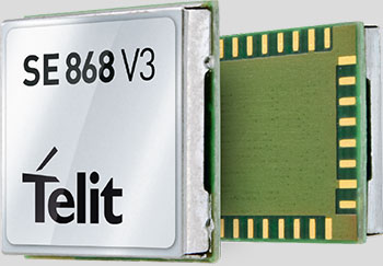
Telit Wireless Solutions has released a new GNSS module, the SE868-V3. The positioning module combines GPS, GLONASS, Beidou, Galileo and SBAS, which enables the creation of high-performance position reporting and navigation solutions.
The SE868-V3 can navigate to -162 dBm and track to -166 dBm, providing improved performance in harsh environments. It is pin-to-pin compatible with the former SE868-V2 as well as the JF2. This advanced GNSS module can track GPS and GLONASS or GPS and Beidou constellations simultaneously and it is Galileo-ready.
The 11 x 11 mm QFN package contains a powerful baseband processor, SQI Flash memory and GNSS chip with integrated low noise amplifier (LNA). The ultra-sensitive RF front-end enables multi-GNSS indoor fix and high-quality navigation in challenging outdoor scenarios such as dense urban areas, Telit said.
In addition, the SE868-V3 supports ephemeris file injection (A-GPS) as well as Satellite-Based Augmentation System (SBAS) to increase position accuracy. Its onboard software engine is able to locally predict short-term ephemeris starting from data broadcast by GNSS satellites received by the module and stored in the internal Flash memory.
“The SE868-V3 is yet another addition to our positioning product portfolio, which is the result of over 20 years of experience in GNSS applications,” said Felix Marchal, chief product officer, Telit. “Our products are compatible with the GPS constellation as well as its Russian counterpart GLONASS and China’s Beidou.”
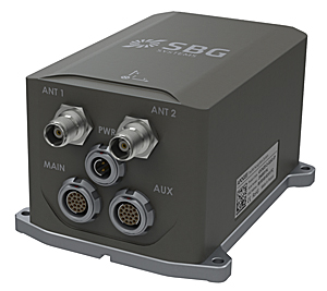
SBG Systems, a manufacturer of inertial navigation systems (INS), has selected the Septentrio AsteRx4 OEM GNSS receiver to equip its Apogee product line. The announcement was made during Ocean Business 2015, held April 14-16 in Southampton, England.
SBG Systems’ Apogee-D
“We are delighted that SBG Systems — a respected specialist in designing INS/GNSS — endorses our newly released GNSS receiver for its performance,” said, Laurent Le Thuaut, business development manager at Septentrio. “The SBG products are recognized amongst the preferred choice for accurate MEMS-based INS and we are extremely proud that our technology is included in their top of the line.”
Apogee is a new product line of high-accuracy inertial navigation systems based on robust and cost-effective MEMS technology. The INS/GNSS solution combines the latest generation of MEMS sensors and the OEM version of the AsteRx4, a newly introduced high-precision GNSS receiver from Septentrio. The Apogee series is especially suited for applications such as hydrography, mobile mapping and aerial survey where survey-grade positioning measurements are required.
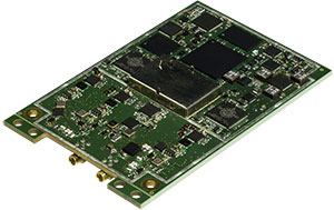
AsteRx4 OEM
The AsteRx4 OEM is a multi-frequency and multi-constellation dual antenna receiver that incorporates the latest innovative GNSS tracking and positioning algorithms from Septentrio. The AsteRx4 is scalable to one centimeter and integrates the entire suite of GNSS+ algorithms proposed by Septentrio to maintain tracking during heavy vibration of machines. This assures position accuracy under difficult ionosphere conditions and mitigates or rejects intentional or unintentional interference with GNSS signals.
“The compact design and the practical and well-designed interface of the AsteRx4 allowed a seamless and an easy integration into our solutions” said Raphaël Siryani, chief marketing & sales officer of SBG Systems. “The AsteRx4 largely contributes to the robust and accurate heading as well as the reduced power consumption of the INS/GNSS Apogee products.”
Both the AsteRx4 OEM receiver and the Apogee INS/GNSS are on display at booth No. W40 (Septentrio) and booth E5c (SBG Systems) at Ocean Business.