Trimble announced today a new version of its Trimble Positions software suite. This new version includes automated workflows to streamline data collection and increase productivity for GIS professionals in a variety of industries such as utility companies, environmental management agencies and municipalities.
With Trimble Positions, GIS professionals benefit from increased productivity through a streamlined and integrated workflow for managing GNSS data collection. Trimble Positions is a collection of Esri software extensions that provide high-accuracy capabilities on the Trimble GeoExplorer, Juno, and Yuma series of field handheld computers, and on Trimble Pro series receivers. Positions software enables high-accuracy GNSS collection on Trimble devices while using familiar Esri workflows to ensure data integrity. New automated workflows in the software further simplify data processing and management, Trimble said.
The latest version of Trimble Positions includes:
Automated Session Processor: Optimizes easier, faster GNSS session data processing with a stand-alone tool to perform automated check-in, postprocessing and feature updates.
Project Wizard: Saves time and avoids errors by guiding users through a step-by-step project set-up featuring streamlined administration screens.
ArcGIS Online Hosted Features Services: Gives users the ability to select ArcGIS Online hosted feature services as a data source allowing them to directly pull their project data from ArcGIS Online into their field collection projects.
Trimble Enhanced GPS Device Support: Positions software is now compatible with the Trimble Juno 5 enhanced GPS handheld and Yuma 2 enhanced GPS rugged tablet for increased choice of device and accuracy level that can be achieved.
Mean Sea Level Heights: Provides greater flexibility by including an option to utilize a geoid model for measuring heights, in addition to the existing ellipsoid model option.
Integration with TerraFlex Software: Saves time by streamlining data transfer between TerraFlex mobile data collection software and ArcGIS for Desktop. This feature integrates the TerraFlex Desktop add-in with the Trimble Positions Desktop add-in to remove the need for separate installations. In addition, fast and easy interoperability is enabled through TerraFlex projects support in the Positions project wizard.
Support for Trimble RTX technology-enabled Geo 7X handhelds: Provides autonomous, real-time submeter positioning in cellular environments with access to Trimble RTX services for Geo 7X users.
“Our customers expect high-quality data, and we need to give them the most efficient means of collecting and managing that data too,” said Alain Samaha, business area director of GIS and Software for Trimble’s Geospatial Division. “Trimble Positions software was specifically developed to meet the needs of our customer that utilize Trimble GNSS devices and Esri workflows. We understand our customers have different requirements and the Trimble Positions solution delivers to meet their needs.”
The Trimble Positions Desktop Add-In, Mobile Extension, Mobile Project Center and Session Processor are available now through Trimble’s authorized GIS Distribution Channel. The Trimble Positions ArcPad Extension is expected to be available in mid-January 2015.
Trimble has introduced a new portfolio of time and frequency products to address the synchronization needs of the growing LTE small cell market.
The products are designed for a wide range of small cell synchronization applications. The products provide increased holdover capabilities and more robust signals with multi-constellation GNSS technology to sync wireless networks more efficiently, Trimble said.
Regardless of whether a network is using 3G, 4G LTE, LTE-Advanced wireless technologies or a combination, synchronization and syntonization are essential for mobile networks. The new LTE-Advanced features — such as Enhanced Inter-Cell Interference Coordination (eICIC), Coordinated Multipoint Transmission (CoMP), Carrier Aggregation (CA) and Multi-Media Broadcast over a Single Frequency Network (MBSFN) — require an even higher degree of precision. Carriers are making significant investments in small cells, LTE-A and Heterogeneous networks to increase capacity and coverage. Network synchronization is a must to achieve both objectives, Trimble said.
The Mini-T GG Disciplined Clock is a multi-GNSS (GPS and GLONASS) embedded module, optimized to generate precise 10MHz output and pulse per second. It utilizes the latest in GNSS technology, combined with a precision ovenized oscillator for near-atomic-clock precision timing. The Mini-T GG provides 24-hour holdover capability and is suitable for pico and microcells.
The Trimble 360 multi-GNSS receiver is designed to cover the full spectrum of small cells — residential femtocell to rural microcell. The Trimble 360 timing products support GPS, GLONASS and BeiDou systems, and are Galileo-ready. In addition to full constellations, the 360 products support Satellite-Based Augmentation Systems (SBAS) and the Asian Pacific Quasi-Zenith Satellite System (QZSS).
The compact, surface-mount ICM SMT 360 timing module, measuring 19 x 19 mm, generates a precise 10MHz reference clock for synchronization of residential and enterprise femtocell networks. It provides holdover capability, which allows the module to extend the availability of reference timing outputs. The Resolution SMT 360 is available in the same 19 x 19 mm form factor, and provides a pulse per second that provides nanosecond accuracy to any application requiring precision time reference such as wireless networks, utilities and digital broadcasting.
The Trimble Mini-T GG disciplined clock, ICM-SMT 360 module and Resolution SMT 360 timing module and starter kit are available now. The Trimble 360 multi-GNSS receiver is expected to be available in January 2015.
NASA is soliciting research on remote sensing techniques that use GNSS for studying the Earth’s environment.
Specifically, the announcement says NASA “seeks innovative approaches to the development of Global Navigation Satellite System (GNSS) remote sensing techniques and algorithms to study the Earth’s environment from the ionosphere to Earth’s interior.” The announcement says NASA is seeking to emphasize the use of reflected GNSS signals for the characterization of the Earth’s surface and mitigation of natural hazards.
Notices of Intent are requested by January 20, 2015, and the due date for proposals is March 20, 2015.
NASA solicits research through the release of various research announcements in a wide range of science and technology disciplines. NASA uses a peer review process to evaluate and select research proposals submitted in response to these research announcements. NASA says that researchers can help achieve national research objectives by submitting research proposals and conducting awarded research. Visit the announcement page for details.
Esri today released its highly anticipated Android version of Explorer for ArcGIS. The native Android app offers access anywhere to data-rich, visually stunning maps. It combines Esri mapping software with the popular mobile-device platform Android.
Governments, utilities, natural resources, and other commercial businesses have already used Explorer for ArcGIS on iOS and OS X to brief stakeholders, tell stories, and find assets. A sketch function enables highlighting and collaborating. In addition, presentation features make map slides easy to navigate and allow teams to interact with mapped information.
The app intelligently scales to device size. Any owner of an Android smartphone or tablet (version 4.0 and up) can explore Esri public maps from anywhere. Examples of public maps users can view include data-rich views of the Bakken oil fields of North Dakota, Alaska’s glacial retreats, and life expectancy by country.
Users with an ArcGIS Online subscription or Portal for ArcGIS account can use the full power of the app, gaining access to their own and their organization’s maps and data.
Explorer for ArcGIS draws on its native Android operating system with sharing capabilities, including e-mail, text messaging, and push notifications.
A Windows version of Explorer is set to be released next year. It will add to Esri’s growing suite of mobile apps that puts intelligent maps into the hands of people with zero to high GIS experience.
Android users can test-drive Explorer for ArcGIS by downloading it for free from the Google Play Store. Learn more about Explorer for ArcGIS at esri.com/explorerapp.
Registration is now open for the Institute of Navigation (ION) Pacific PNT 2015, set for April 20-23 at the Marriott Waikiki Beach, Honolulu, Hawaii. Pacific PNT’s theme is “Where East Meets West in the Global Cooperative Development of Positioning, Navigation and Timing Technology.” The conference brings together policy and technical leaders from Japan, Singapore, China, South Korea, Australia, the United States and more for policy updates, program status and technical exchange.
This year’s theme, Global Cooperative Interoperability, will frame the technical program. Leaders representing academia, government, industry and the scientific community will convene to solve PNT challenges that impact Pacific Rim development.
Pacific PNT 2015 is organized by the Pacific Rim Advisory Board and will feature technical papers presented on a diverse array of PNT topics including:
Algorithms and Methods
Aviation Applications of GNSS
Automotive and Land Vehicle Navigation
Contemporary and Challenging PNT
Earthquake and Environmental Monitoring with GNSS
GNSS Acquisition and Tracking Algorithms
Aircraft Navigation and Surveillance
Ground Based Augmentation System Technology
UAS Technologies and Applications
GNSS Correction and Monitoring Networks
PNT Policy/Status Updates
GNSS Signal Structures
GNSS Augmentations
Alternative and Collaborative Navigation
Inertial Navigation Technology and Applications
Ionosphere Monitoring with GNSS
Interference and Spectrum
Time and Frequency Distribution
For more information the ION’s Pacific PNT 2015, visit www.ion.org/pnt.
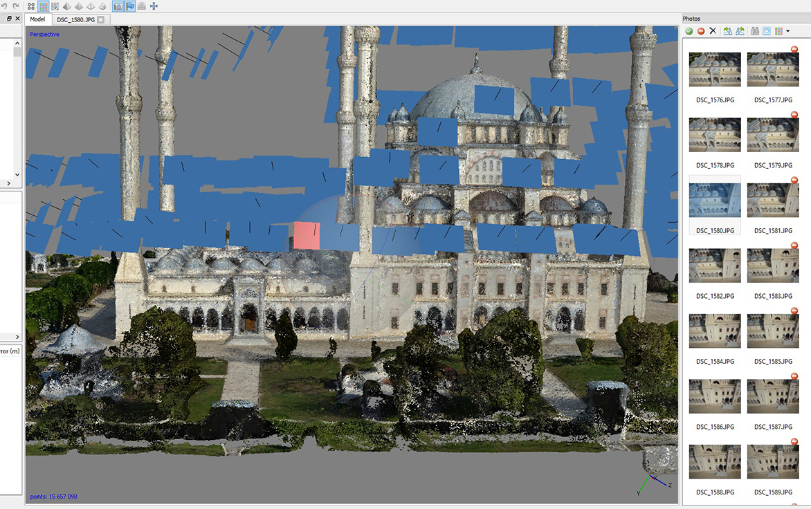
The Sabancı Merkez Mosque in Adana, Turkey, has been inspected and mapped by an unmanned aircraft system and a detailed 3D model created. The work was carried out by SISTEM A.S. (the Turkish distributor of Leica Geosystems), NRJ Engineering and Aibotix.
Sabancı Merkez Mosque is the largest in Turkey, with six minarets, four of which are 99 meters high. The largest of its five domes is 32 meters in diameter and 54 meters high, so determining the actual state of the building using conventional methods would be time consuming and costly. Instead, the authorities commissioned a UAV inspection.
“We needed only three flights to cover all relevant areas and generate comprehensive data,” said SISTEM A.S. employee Bora Yavuz, who has been working with terrestrial laser scanning systems for the past five years. “Compared to laser scanning, collecting the data from the top sections of this huge building by UAV was extremely easy, since nobody had to climb up to the minarets or dangerous places on the domes and wait for the machine to scan. Furthermore, alongside the data registration the generation of point clouds runs automatically.”
During the flight over the roof of the mosque, the UAV followed a defined route that had been planned on the computer beforehand. The pilot then steered the UAV manually in two more flights around the building.
The Aibot X6 was carrying a Nikon Coolpix A digital camera and created high-resolution photos with an 80 percent overlap. Using live images from the UAV’s perspective that were sent directly to the screen of a ground station, the pilot could make sure that all relevant areas were captured, and achieve the best possible results by adjusting the camera to the optimum angle during the flight.
The data was subsequently processed to create an accurate 3D model of the mosque with a precision down to 1-2 centimeters. The high-resolution photos are linked to the model so that damage can be located accurately, with GPS information synchronized with the images for fast post-processing. The images and the model will now be used as the basis for maintenance and repairs.
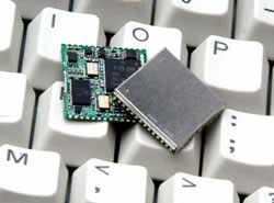
Bartec Pixavihas launched the “Impact X intrinsically safe smartphone” based on u-blox’ rugged 3G cellular module technology designed for devices used in tough industrial and outdoor environments. Bartec Pixavi is a manufacturer of mobile devices used in hazardous or explosive environments such as oil platforms, mines and chemical plants.
“Our Impact X smartphone is designed with the most robust, reliable and safe components available to ensure security and provide reliable connectivity to workers in potentially dangerous locations,” said Christian Rokseth, CEO of Bartec Pixavi. “We chose u-blox’ cellular module technology because of its industry-leading performance, excellent environmental tolerance and reliability.”
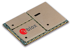
u-blox LISA u230 module. Photo: u-blox
The Impact X is CSA Class 1, Zone 1, IECEx and ATEX Zone 1 certified, explosion proof, waterproof and extremely ruggedized. At the heart of the Impact X is u-blox’ professional-grade LISA-U230 six-band 3G cellular module with 2G fallback capability. LISA modules also provide fully integrated access to u-blox GNSS receivers to enable advanced location-aware applications. Antenna diversity permits LISA-U2 modules to provide the highest data speeds.
“The Impact X is an excellent example of a high-performance mobile device that demands performance well beyond what is provided by standard mobile phones,” said Armin Boeshenz, General Manager of u‑blox sales EMEA. “We are extremely pleased to be a key module supplier to demanding customers such as Bartec Pixavi as proof of our industry-leading quality and reliability.”
u-blox LISA-U2 modules are suited for networks worldwide. Features include data-rates of up to 21.1 Mb/s (downlink), a rich set of Internet protocols, very small footprint, very low power consumption and extended operating temperature range of -40 to +85 degrees C.
Amazon.com is warning the Federal Aviation Administration (FAA) that it will move its drone research abroad if it doesn’t get permission soon to test-fly in the United States, reports TheWall Street Journal. Amazon has already begun researching drone flights in the United Kingdom.
“Without the ability to test outdoors in the United States soon, we will have no choice but to divert even more of our [drone] research and development resources abroad,” wrote Amazon’s vice president of global public policy Paul Misener in a letter to the FAA, according to The Wall Street Journal. “I fear the FAA may be questioning the fundamental benefits of keeping [drone] technology innovation in the United States,” Misener wrote.
The FAA is required by U.S. Congress to frame a “safe integration” plan for the commercial use of UAS by Sept. 30, 2015. Changes in the law could restrict users of commercial UAVs by requiring licenses, with licenses issued to users only after many hours in the cockpit of a manned aircraft, comparable to traditional pilot licenses. The new rules would also limit flights to under 400 feet and within sight of the person at the controls, which is the current rule for hobbyists.
One of the FAA’s concerns is conflicts with manned aircraft. FAA data shows dozens of dangerous encounters around the country over the past six months, according to the Washington Post. Since June 1, commercial airlines, private pilots and air-traffic controllers have alerted the FAA to 25 episodes in which small drones came within a few seconds or a few feet of crashing into much larger aircraft. Many of the close calls occurred during takeoffs and landings at the nation’s busiest airports, presenting a new threat to aviation safety after decades of steady improvement in air travel.
Read one blogger’s account of a close call using a drone, partly caused by loss of the GPS signal.
Nasdaq — the trading and exchange technology company — is launching a trade time-stamping service at its data center in Carteret, New Jersey, with access to a NIST-certified GPS antenna. The High Precision Time service is provided by Perseus, a provider of global high-speed connectivity, and enables Nasdaq customers to synchronize their time systems across a multitude of data centers.
High Precision Time offers access to a National Institute of Standards and Technology (NIST)-certified GPS antenna as well as Network Time Protocol (NTP) and Precision Time Protocol (PTP) connectivity with nanosecond accuracy to the Coordinated Universal Time UTC (NIST) timescale. These NIST-certified options allow Nasdaq co-located clients at the Nasdaq data center in Carteret to synchronize their system clocks. This tool can be used as clients’ primary time service, or as a back-up for clients which already use Nasdaq’s shared GPS service or have their own dedicated GPS antenna.
“The relationship with Nasdaq is an important step in helping our shared customers mitigate the risks of inaccurate time stamps when disseminating and trading on sensitive market information,” said Anthony Gerace, President, Global Financial Services at Perseus Telecom. “This is especially important for compliance and high-precision trading.”
Nasdaq co-located clients can connect to High Precision Time services via a simple inter-cabinet cross-connect with:
Certified NIST GPS antenna access
Certified UTC (NIST) timescale accuracy and reporting
Choice of delivery protocols: NTP (Network Time Protocol) and PTP (Precision Time Protocol)
“Our adoption of Perseus’ precision time service is another example of our commitment to provide member firms with technology solutions that reduce risk exposure,” said Stacie Swanstrom, Head of Global Access Services and senior vice president of Global Trading and Market Services at Nasdaq. “Transparency and choice is a hallmark of Nasdaq’s philosophy, which is why we continuously improve our Nasdaq Data Center environment while being mindful of the challenges and complexities of the markets.”
UAVs Revolutionizing Aviation: Exciting Challenges for the PNT Community
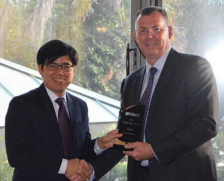
Sherman Lo, accepting Leadership Award from Mark Stewart.
Sherman Lo, Senior Research Engineer and Associate Investigator (APNT), Stanford University. One of the architects of eLoran and a worldwide thought leader on alternative PNT.
Remarks
I’m not very good at predicting the future but I know what is exciting to an aviation nerd like me — UAVs. I believe that unmanned autonomous vehicles will revolutionize aviation’s role in society.
UAVs have expanded the community of participants in aircraft development from solely the realm of large defense firms to individuals. The makers amongst us can fabricate custom parts for custom designs and order electric engines from across the sea. Our students have a class where they design and build sub-100-gram autonomous UAVs. They allow for rapid development and prototyping of technologies. All sorts of new crazy business models will be developed for their use.
This is significant for the PNT world because the proliferation of UAVs and what we are able to do with them is enabled by GNSS. That being said, for the good of the community, we also need to take steps to allow UAVs to fully realize their benefit to society. UAV navigation is a rich field.
Navigation improvements can significantly benefit UAV operations. For example:
A robust alternative navigation capability would continue to fly in case of GNSS loss.
An ability to authenticate the UAV’s location would be useful for delivery confirmation and other services.
The ability to range/sense/share information is needed for UAVs to collaboratively and safely use the airspace.
The solution may come in the form of using existing signals, new signals, inertial, vision, all of the above, or none of the above.
UAVs comes in all shapes and sizes, from the little one that our kids play with to the 10-kilogram octocopter in our lab, to even larger ones planned for package delivery to the Globalhawks, with wingspans larger than a 757’s, that I was fortunate to come face to face with at Edwards Air Force Base. There is no one-size-fits-all as UAVs are being developed in all shapes and sizes for many varied missions. I think that is a fun, interesting, and exciting challenge for the PNT community.
Introduced by…
Mark Stewart, Lockheed Martin VP of Navigation Systems, introduced the Satellite Leadership Award.
“I’ve been in the space business for 30 years, and I’m very honored to be part of this navigation community. One of our roles as technical leaders, all of us here, is to educate and coach the young engineers to take over this business as we move on.
“In that context, I reflect back on one of the tests that I had to take to enter college. One of the very simple questions, to start the test, was ‘Where does milk come from? A cow, a carton, a rock, or the moon?’ And I, being raised on a dairy farm in upstate New York, obviously circled cow. When we were graded, all of us received a letter back in the mail from the testing institution. It stated they were going to give credit for two answers, depending on where you came from. If you came from an inner city, in fact milk did come from a carton, so they gave credit for that.
“As an educator, I felt I wanted to go through my life educating people as to where things really come from. where they originate, and who to thank for those things they bring into our life.
“So, as a teaching moment here: the next test that comes up, probably in our children’s lives, will be ‘Where does GPS come from?’ One of the answers will be, undoubtedly, ‘a cell phone.’ Why do we need GPS when we have it in our cell phones, right? However, the correct answer is going to be — circle this — ‘All of you.’ We have GPS because of all of you in this room, the leadership you provide to your teams and all those team members we have back at home.
“So. I want to thank you all for being part of the GPS community and doing what you do so well, for the warfighter and for the civilian population as well. I thank you from the deepest part of my heart for what you do.
“I also want to thank all the award winners here tonight, and congratulations on their significant accomplishments.”
SATELLITES
Galileo’s Top Five for the Future: Accuracy, Robustness, Ephemerides, Time to First Fix, and Authentication
Javier Benedicto Ruiz
Javier Benedicto Ruiz, Galileo Project Manager, Directorate of Galileo Programme and Navigation-related Activities, European Space Agency. For directing a program that produced initial signal results better than the design specifications. (Accepted on his behalf by Marco Falcone, ESA’s Galileo System Manager).
Remarks
On behalf of Javier Benedicto, I would like to thank GPS World for this award. Javier feels really honored by this award you have decided to grant to the Galileo achievements of the last year. We are proud of what has been achieved, despite the difficulties — and believe me, we are very professional in addressing the difficulties in these days — we are fully determined to bring the Galileo system into full deployment, and the diverse services to GNSS users worldwide.
Javier wants to emphasize that the merit of our achievement is thanks to every single individual of an excellent team we have in the Galileo Project Office at the European Space Agency.
From a satellite system perspective, I will give a vision of the directions of the future from 2020 onwards. I have for you the Top Five issues that GNSS should address in the future.
Marco Falcone
The first one is better ranging accuracy, to a level of 10 to 15 centimeters. This would allow techniques to support more closely PPP instantaneous ambiguity resolution. For that, we need stable clocks and clock ensembles onboard.
Second, enhanced robustness and availability to reach PNT solutions everywhere. This can be done through signal-in-space encoding, interleaving, satellite diversity to be implemented not only at the level of the satellite systems, in fact I expect there will also be a lot of work to be done by receiver manufacturers to manage all these types of signals available from the different constellations.
Number three, long-term ephemerides with a validity up to one week, even up to 14 days. This is a very important point. How to achieve it? Through stable orbits without station-keeping, reducing station-keeping as much as possible, and highly stable clocks, like the new generation of hydrogen masers that we have onboard Galileo satellites at the moment.
Fourth, a faster time to first fix, up to one to two seconds for single/dual frequency users, using navigation message-aided information on top of ephemerides loaded with a duration up to 14 days.
Number five was discussed today by many papers in the conference: authentication, at the level of the navigation message, or at the level of ranging, with a clear identification of what will be the requirements of the future.
I have a bonus on top of the five: that is timing accuracy to a level of a service of 5 nanoseconds. I believe this is possible. We are already able today to reach up to 7 to 10 nanoseconds. This would allow at the end to have real-time universal time available to all users.
This is our message for the future. I thank you a lot for this award, for all the members of our great team.
Introduced by…
Lori Thompson
Exelis Geospatial Systems Vice President Lori Thompson helped introduce this year’s GPS World Leadership Award recipients at the dinner honoring engineers and scientists. Prior to the introductions, Thompson discussed the importance of innovation across the field of position, navigation, and timing, and the Exelis commitment to the ongoing advancement of timing and location technologies.
Exelis is on the Lockheed Martin GPS IIR & IIR-M team, which recently celebrated supporting the U.S. Air Force with 200 years of on-orbit success. Exelis is also supporting Lockheed Martin on the GPS III program, developing a new next-generation navigation payload.
“We take a great deal of pride in our core role with the Air Force GPS program,” Thompson said. “The Air Force mission is our mission. Ensuring the availability of the GPS signal to support day-to-day activities and critical operations is the reason Exelis continues to innovate in PNT.”
Thompson talked about the company’s ongoing initiatives to assure the GPS signal, specifically technology called Signal Sentry that helps detect and geolocate sources of interference.
SERVICES
High Precision in High Volumes: From a Circuit Card in a Handheld Computer to RTK in Your Mobile Phone
Eric Gakstatter, Contributing Editor for Survey and Geospatial Solutions, GPS World. For several widely read columns on what it will take to see large-scale consumer adoption of centimeter-accurate positioning.
Eric Gakstatter
Remarks
I have to say, I’m thoroughly embarrassed and deeply humbled to be up here. I’ve written about all of you or some of you at some time along the way, or at least the work that you’ve done.
I’d like to talk for a minute about history. I began my GPS career back in 1990. I was a 27-year-old product manager, and my boss came up to me and slapped a copy of GPS World magazine on my desk and said, “We need to do this.” It was a full page advertisement by Magnavox with a six-channel GPS engine, which was just a circuit card. We made handheld computers at that time. So we decided, hey, let’s take one of these boards and engineer it inside one of our handheld computers and make a data collector out of it for surveying and mapping.
I spent the next two years pretty much living at the office trying to make this happen. We ended up introducing some products, and several more after that. A few points of interest I recall:
I don’t know if Ron Hatch or Rich Keegan are here, but I remember running down to their office in Torrance and visiting with them about this whole concept; Tom Stansell was there at that time, too. Just to give you an indicator: the cost of that receiver board — I remember we paid $510 for a six-channel receiver, code and carrier, and I tell you the measurements on that receiver were tremendous back then. It’s really the basis, I think, for the WM101, which five years earlier was selling for $50,000 for a four-channel receiver.
So we get to today. I was listening to a panel this morning about low-cost, high-precision receivers, and a gentleman from China was talking about his prediction that at the year 2020, an RTK GNSS chipset would be about $20, and an RTK GNSS module about $100.
I tend to agree with him. I think it’s going in that direction. I’ve written a lot about, not necessarily the commoditization of high precision or RTK GNSS, but certainly a much wider audience for it. And if you watched that panel, you noticed that of all the people on that panel, he’s the one who talked about a broad audience: this high-precision GNSS making it, not maybe to the mass market, but certainly in the millions and maybe tens of millions of folks.
As far as predictions go, I think it’s just a matter of time before this happens. I appreciate what Todd Humphreys said a couple of years ago at this dinner, where he predicted RTK in your mobile phone by the year 2020. I’m onboard with that, and I’ll promote it as much as I can, and I hope that someone brings this to fruition. If it’s 2022 or 2021 or 2019, I think it’s just a matter of time before that happens.
Last, I’d just like to thank all of you for creating some great content and making it easy for me to write. Thank you.
Introduced by…
Matthew Gilligan
Matthew Gilligan, Raytheon Program Manager for the GPS Next Generation Operational Control System, introduced the Services Leadership Award.
“It is great to be here with men and women who understand the history and power of GPS, and it’s an honor for me to be here to help celebrate the GPS World Leadership Award winners.
“For the past 30 years, GPS has ensured weapons have found their targets, and ships at sea have returned to port. GPS has enabled the deployment of UAVs and has made sure that military missions of all kinds have been a success. GPS is a life-saving technology, ensuring soldiers come home safely.
“Today, GPS continues to grow in importance. Embedded sensors, mobile devices, and the interconnected technologies that are defining a new era of technology and our economy through the Internet of things — all enabled by GPS’s positioning, navigation and, so importantly, timing.
“To everyone in this room today, I want to say thank you for ensuring the mission evolves and continues.
“I have been asked to speak because I am leading Raytheon’s partnership with the Air Force in modernizing the ground segment — what we like to call the brains of GPS. My program, OCX, is at the core of the Air Force’s GPS modernization initiative. OCX will bring unprecedented new capabilities to GPS users worldwide:
enabling operational availability of all new civil and military signals,
protecting GPS against current and emerging cyber threats — setting the bar for information assurance at an unprecedented level,
improving system accuracy and integrity,
securely sharing information with net-connected users, and
providing flexibility and evolvability to meet future mission needs.
“OCX represents new approaches to emerging and even unimaginable changes and threats. And we are glad to recognize so many of you who are making it possible.
“We are excited to be here tonight with our partners, our customers, and even our competimates as we plan for and look forward to the future.”
PRODUCTS
Bringing SatNav Future into View: A Platform for Early Familiarization with New Constellations
Oliver Montenbruck
Oliver Montenbruck , Head, GNSS Technology and Navigation Group, DLR, German Space Operations Center. The principal driver behind the IGS Multi-GNSS Experiment project, whose free, real-time products could be a game changer for inexpensive multi-constellation RTK.
Remarks
Being selected for this prestigious award fills me with great pride and happiness, as well as deep gratitude. I would foremost like to thank you and GPS World, but also the unknown colleague who nominated me. However, it is the community that participated in the poll and ultimately selected me in this highly competitive contest. Thanks as well to all of you: your trust in my work and your recognition is truly appreciated!
Unfortunately, I can’t be here today to accept the award and to thank you in person, but have asked my colleague André to do so on my behalf. I’m presently staying in the Southern Hemisphere, which is not a fault of my GPS device, but was already planned some time before I learned about today’s event. Nevertheless, my thoughts are with you in Florida on this memorable evening.
I would like to elaborate a bit on the IGS Multi-GNSS Experiment, its background and status.
André Hauschild
The International GNSS Service, IGS, is a volunteer organization with more than 200 participating institutions worldwide. Over the past 20 years it has been the premier source of highest quality GNSS data, products, and related standards and conventions. There is hardly any student, engineer, or scientist in the field of GNSS that has not made use of IGS resources. Through its work, IGS supports a wide range of GNSS-related applications for the benefit of the scientific community and society as a whole.
The IGS has traditionally focused on GPS and GLONASS, but it is obvious that the world of GNSS is rapidly changing these days. With BeiDou, we already have a third operational satellite navigation system offering an at least regional service. Europe is actively pursuing the build-up of Galileo, which will offer another global navigation system with advanced performance features and new service types. And, last but not least, Japan and India are in good progress to establish QZSS and IRNSS as independent regional systems.
The new systems come with a multitude of new frequencies and a plethora of new signals. Industry has already done a great job, and nowadays offers a wide range of receivers and antennas for multi-frequency, multi-constellation tracking. However, we are only at the verge of making full use of the capabilities offered by the new GNSSs, and we still have a stony path ahead, before we can arrive at a “system of systems” as Günther Hein once phrased it.
In view of a rapidly changing GNSS landscape, the IGS decided three years ago to launch the Multi-GNSS Experiment, MGEX, as a platform for early familiarization with the new constellations. Within three years, the MGEX network has grown from zero to more than 100 globally distributed stations and presently supports tracking of all GNSSs with the sole exception of IRNSS. MGEX data have helped to gain experience and to characterize the new signals. They also served as a basis for pioneering work and various discoveries. The GPS L5 signal and CNAV navigation message, the Galileo high-performance hydrogen masers, and the BeiDou triple-frequency signals are just a few highlights that could be investigated in detail thanks to the MGEX network.
Building up on MGEX observations, a set of core products is now available for Galileo, BeiDou, and QZSS. These include precise orbit and clock solutions, differential code biases, as well as cumulative broadcast ephemerides. More products and a quality-control process will be implemented as we proceed and as we are able to gain new volunteers and workforce. All MGEX data and products are freely available to the community and will certainly form a starting point for excellent research and many Ph.D. theses at universities around the world.
It is a great honor for me to lead the MGEX project for more than two years now. Numerous achievements have already been made in that period, but we are also determined to make further progress as more and more satellites are launched and as we learn to better understand the “dirty details” of multi-GNSS processing. It has been a great pleasure to lead an experienced and highly motivated team, and it is actually they who should be awarded for their great work. I take this award today as an encouragement to pursue our work and to expand the IGS to a full featured Multi-GNSS Service for everyone’s benefit.
Thank you once more, and enjoy this fantastic evening.
Introduced by…
Ed Baron
Ed Baron, Director, Braxton Technologies, introduced and awarded the Products Leadership trophy.
“I’d like to thank Alan and his GPS World team for organizing this dinner allowing us to take the time to recognize tonight’s recipients.
“I have the good fortune to be here representing Braxton, a small business dedicated to delivering innovative capabilities on the GPS Program along with our partners; Lockheed, Exelis, and Raytheon.
“We are honored to help congratulate the recipients. This is a competitive area, and to be recognized in this field is a tremendous achievement. A strong ‘Well done!’ to every one of you.”
Esri is offering a Severe Weather Public Information Map that charts instances of severe weather throughout the United States and Canada. Weather events tracked include snowstorms, tornadoes, floods, hail storms, wind storms, and short-term weather warnings issued by the National Oceanic and Atmospheric Administration (NOAA).
The map features live feed layers. Users can click on reports and warnings to receive information about the specific location and read a short description about the issue. Radar is provided by AccuWeather and Environment Canada as part of the Esri Disaster Response Program.

 The latest version of Trimble Positions includes: