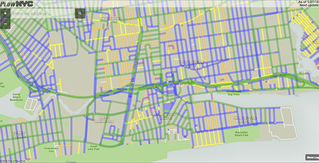
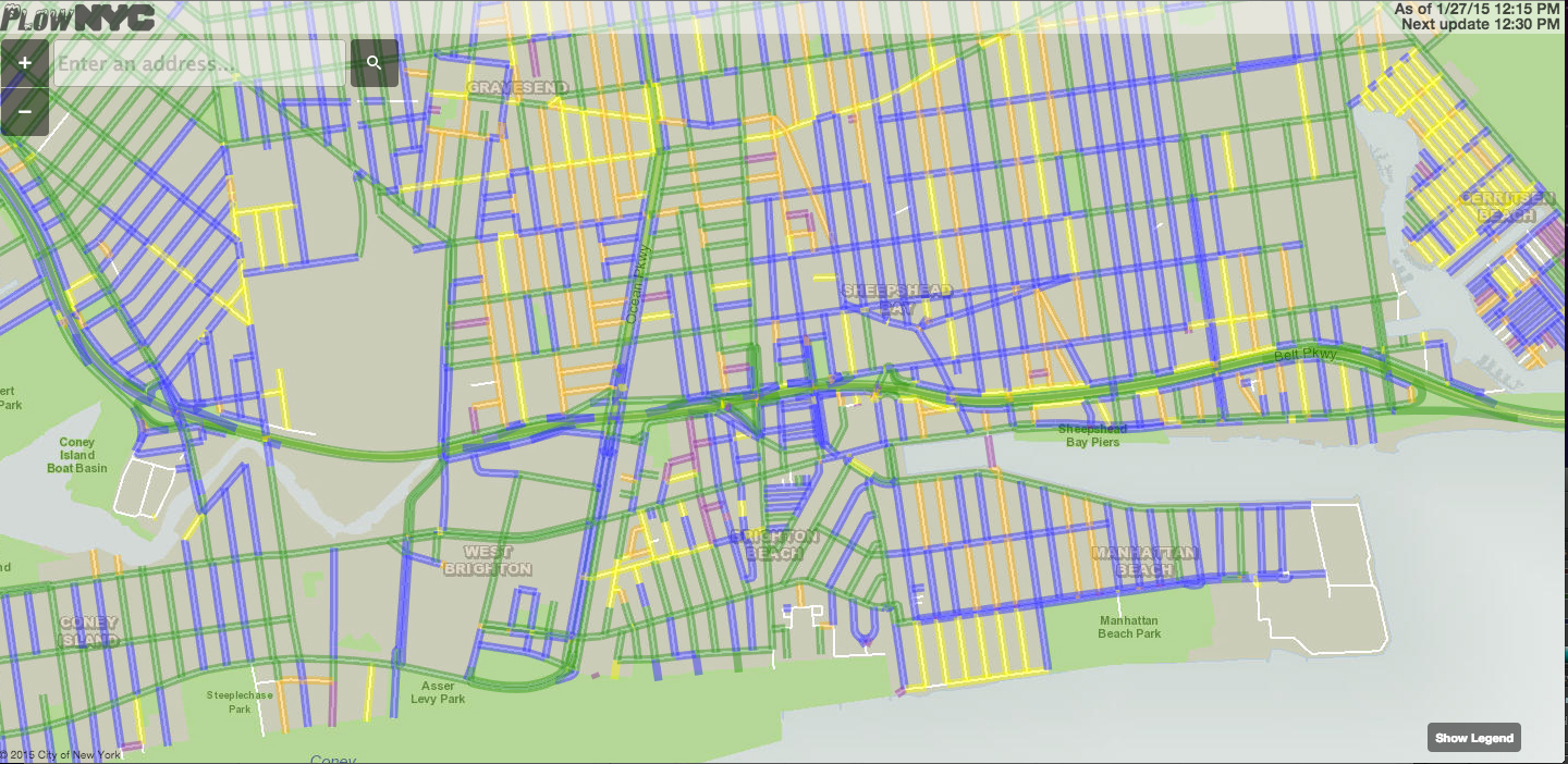
Snow plows in many cities cleaning up the snow from a winter storm that blasted the Northeast are being tracked with GPS. One website application, PlowNYC, provides real-time updates on where the plows are in the Big Apple, according to CBS News. PlowNYC was developed by Rastrac, a GPS fleet tracking and remote asset management solution company.
The New York City sanitation department is deploying 2,550 plows and more than 2,400 workers to combat the storm. “The city actually tracks all the snow plows and aggregates all of that information and make it available to New Yorkers on this map,” data scientist Ben Wellington told CBS News. “Green lines on the map show the roads that have been plowed in the last hour whereas the blue line shows the streets that have been plowed in the last one to three hours.”
New York isn’t the only city applying this kind of technology. For the first time, Pittsburgh residents can track their plows in real time. Chicago has been sharing it’s plow data for the last several winters.
“I think for the public, it gives them a sense of security to see where things are happening and feel like they can hold us accountable,” New York City sanitation commissioner Kathryn Garcia told CBS News. “At the end of the day, we work for them.” The apps also reduce the number of calls to city call centers.
Esri’s interactive Severe Weather Public Information Map and U.S. Snowfall Forecast Map enable users to see winter storms, including the massive storm that’s about to hit the Northeastern United States. Here are the two maps.
Severe Weather Public Information Map
With the Severe Weather Public Information Map, users can view continuously updated weather reports and warnings from the National Oceanic and Atmospheric Administration (NOAA) and the National Weather Service, along with live weather data from AccuWeather.
Users can also explore geotagged social media from Twitter, Flickr, and YouTube related to the storms.
U.S. Snowfall Forecast Map
This map shows the projected accumulation of snowfall across the U.S. for the next 36 hours, using data from National Weather Service Digital Forecast Database. Users can step through projections in six-hour increments for a more accurate view of when and where snowfall is expected to be most severe.
San Francisco-based startup Planet Labs has raised $95 million from investors in its latest round of financing. The company’s goal is to provide frequent, inexpensive, high-quality Earth imagery to a variety of customers.
“I’m pleased to announce a first closing of a planned $70 million Series C round led by Data Collective. This financing includes a debt facility of $25 million from Western Technology Investment, bringing the total financing to $95 million,” said co-founder and CEO Will Marshall.
Planet Labs builds Earth-observation satellites that are a mere 12 x 4 x 4 inches. Each of the miniature satellites, which the company calls “Doves,” can capture imagery with a resolution of 10 to 16.5 feet (3 to 5 meters).
Planet Labs, founded in 2010 by three former NASA scientists, has launched 73 Doves into orbit. The first prototypes blasted off in April 2013. In January 2014, Planet Labs delivered Flock 1, a constellation of Earth-imaging satellites made up of 28 Doves. Subsequent launches have increased the current constellation to 71 Doves. The goal is to be able to image the entire Earth every day.
Doves being deployed from the International Space Station. Photo: NASA
Once the satellites are operational in orbit, they each complete a full circuit of the planet in about 90 minutes, capturing images as they travel. When a satellite makes contact with a ground station in the company’s network, Planet Labs receives images and migrates them to the cloud, as well as transmitting additional instructions to the satellites.
According to the company website, Planet Labs provides commercial and humanitarian value with its global imaging network. Industries supported include geospatial, agriculture, civil government, and natural resources. “Fresh data from any place on Earth is foundational to solving commercial, environmental, and humanitarian challenges,” the website said. “Our global sensing and analytics platform unlocks the ability to understand and respond to change at a local and global scale.”
Planet Labs says it provides the industry’s most frequently updated imagery of any place in the world at 3-5 meter resolution. The data supports customers who need easily accessed, fresh imagery to inform their day-to-day operations, data analysis, and products. Each image is processed through the company’s automated data pipeline and delivered to customers via API and web tools.
“This financing comes in the wake of our successful launch of 73 satellites, customers actively using our data, and the recent hiring of Tom Barton as our chief operating officer. Tom was formerly CEO of Rackable Systems (now SGI) and boasts over 25 years of experience managing and advising hardware and software companies,” Marshall posted on the Planet Labs website. “With strong support from new and returning investors, Tom on board the management team, and a brand new headquarters in the heart of San Francisco, we’re primed to deliver more insights about our changing planet in 2015.”
The Dawesville Channel in Western Australia as seen by a Planet Labs satellite. Photo: Planet LabsThe Kashima Industrial Zone is one of the Japan’s largest industrial parks, home to an estimated 1,500 factories. The plant at the image’s center manufactures steel sheets found in home appliances and auto parts. A low-density residential area (upper left) lies just west of the industrial zone. Photo: Planet Labs
Water management company DHI used satellites to map Jan. 11-13 floods in Denmark.
On the weekend of Jan. 9-11, two storms passed over Denmark. During and after the storm flood warnings were issued in different areas of the country. To monitor and map the spatial extent of the flooding DHI GRAS asked Airbus Defence and Space to acquire TerraSAR-X satellite images over the areas. DHI then analyzed and mapped the flooded area.
The main advantage of using radar satellites like TerraSAR-X is the ability to acquire images independent of weather and light conditions, DHI said. It is possible to get an image of the actual conditions on the ground even during harsh winds (up to 35 to 40 meters per second in this case), massive clouds and rain, and during the night.
The illustration below shows parts of the flooded area around Limfjorden in Northern Jutland, Denmark. On the background radar satellite image the water is black while land area appears in white and grey tones. The light blue overlay indicates flooded areas.
The images were acquired over various parts of Denmark. By preparing and reacting to future and similar early warnings of flooding and storm events, it is possible to plan for new images to be acquired during the maximum extent of the water level.
CNN has entered into a Cooperative Research and Development Agreement (CRDA) with the Federal Aviation Administration to advance efforts to integrate unmanned aerial vehicles (UAVs) into newsgathering and reporting.
The cooperation arrangement will integrate efforts from CNN’s existing research partnership with the Georgia Tech Research Institute (GTRI). Coordination between and among CNN, GTRI and the FAA has already begun. The FAA will use data collected from this initiative to formulate a framework for various types of UAVs to be safely integrated into newsgathering operations.
“Our aim is to get beyond hobby-grade equipment and to establish what options are available and workable to produce high quality video journalism using various types of UAVs and camera setups,” said CNN Senior Vice President David Vigilante. “Our hope is that these efforts contribute to the development of a vibrant ecosystem where operators of various types and sizes can safely operate in the US airspace.”
“Unmanned aircraft offer news organizations significant opportunities,” said FAA Administrator Michael Huerta. “We hope this agreement with CNN and the work we are doing with other news organizations and associations will help safely integrate unmanned newsgathering technology and operating procedures into the National Airspace System.”
We’ve changed the way subscribers can access the digital edition of our monthly GPS World magazine.
Digital subscribers can access the digital edition by an email notification that will appear in their inbox. Just click on the link provided. Accessing the digital edition this way is easy — you won’t need to enter your subscriber number.
However, if you need to know your subscriber number, you can access it from the email notification.
Print subscribers can also access the digital version of the magazine by entering their subscriber number when prompted. Your subscriber number can be found on the label of the printed magazine or within the digital email notification. See sample image below.
Photo: GPS World
When accessing the digital edition from the website, a newsletter, or the iTunes or Google Play store, you may need to enter your nine-digit subscriber number. Any subscriber may access the content as long as he or she subscribes to the monthly magazine — either the print or digital format.
If you are not yet a subscriber to the monthly magazine, signing up is easy and, in most instances, free for anyone working in the GPS/GNSS industry. Simply complete the online subscription form.
The first few pages of each monthly digital edition is available as a preview. When the maximum number of views is reached, the reader will receive a prompt to enter the subscriber number.
The CBP’s unmanned aerial program includes the Predator B aircraft, as well as ground control stations, pilots, sensor operators, video cameras, land and maritime radar, and communication equipment. (CBP Photo)
A new report by the Department of Homeland Security’s Inspector General’s office finds that use of unmanned aerial drones to patrol the U.S./Mexico border is not effective. The Customs and Border Protection’s (CBP) Unmanned Aircraft System program has been in operation for eight years.
Problems include a lack of performance measures and sky-high operational costs, according to the report, which was issued January 6. “Specifically, the unmanned aircraft are not meeting flight hour goals, and we found little or no evidence CBP has met its program expectations,” the report said. “We estimate it costs $12,255 per flight hour to operate the program; CBP’s calculation of $2,468 per flight hour does not include all operating costs.”
The $443 million CBP plans to spend on program expansion could be put to better use by using alternative technologies, the IG concluded.
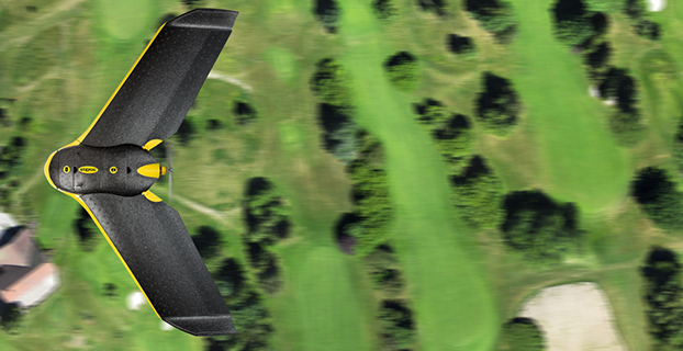
The eBee Sensefly UAV. Photo: Advanced Aviation Solutions
The Federal Aviation Administration (FAA) today granted two more regulatory exemptions for unmanned aircraft systems (UAS) operations for commercial use.
The two companies are Advanced Aviation Solutions of Spokane, Wash., and Tierra Antiqua Reality of Tuscon, Ariz. Advanced Aviation Solutions plans to fly an eBee senseFly UAV Ag system carrying a georeferenced still camera to conduct photogrammetry and crop scouting in order to perform precision agriculture.
The eBee Ag system consists of a 1.5-pound battery-powered aircraft, a personal computer-based ground control station, and associated communications equipment. The UAV is a fixed-wing aircraft with a wingspan of about 3 feet and 2 feet in overall length, which can operate at a maximum speed of about 50 knots.
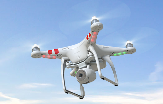
Tierra Antiqua Reality plans to operate a Phantom 2 Vision+ UAS, which is comprised of an unmanned aircraft and a transportable ground station. The company plans to attach a small ultra-6 lightweight GoPro 3+ camera to the Phantom and operate it over various areas near Tucson to enhance academic community awareness and augment real estate listing videos.
The Phantom is a 3-pound quadcopter with a maximum airspeed of 30 knots.
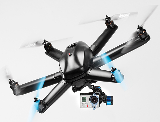
HEXO+, an autonomous flying camera system, by Squadrone Systems will exhibit at CES 2015.
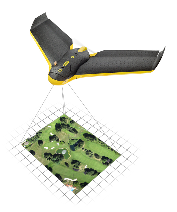
An Unmanned Systems Marketplace debuts this year at the annual International Consumer Electronics Show (CES), being held this week in Las Vegas. The marketplace highlights the burgeoning technology in drones, unmanned aerial vehicles (UAVs), and other unmanned systems controlled by onboard computers or remotely from the ground.
Also, a session on drones will focus on safety and privacy of commercial UAV use.
The Unmanned Systems Marketplace is at CES Tech East, in the Las Vegas Convention and World Trade Center (LVCC), South Hall 2. Tech East includes the LVCC, the Westgate Las Vegas , and Renaissance Las Vegas. Exhibitors at the marketplace include AirDog, Squadrone, Trace, DJI, iRobot, Trace, Torquing Group DBA ZANO, Ecovacs, EHang, Autel, Pelican Products, and other brands.
According to the CES description of the marketplace, “Drones, UAVs and other unmanned systems have taken off as a unique tool for everyday life, regardless of whether flight is controlled by onboard computers or remotely from the ground. Unmanned systems have revolutionized the way we capture, monitor and assist our world. They provide aerial coverage for sports, travel and real estate; enhance search and rescue, law enforcement and disaster relief; and so much more. Experience the variations in design and functionality of this technology with these current exhibitors in the all-new Unmanned Systems Marketplace.”
The session description reads, “The use of unmanned aerial vehicles (a.k.a. drones) for mapping, surveillance, newsgathering, filmmaking, and recreation is on the rise. Drone experts explore commercial and consumer market opportunities — including using drones to deliver packages — and address issues about safety and privacy.”
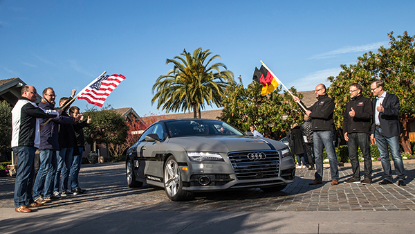
Start of the 550-mile piloted drive from Silicon Valley to Las Vegas: Ricky Hudi, Audi executive vice president electric/electronic development (left) and Ewald Gössmann, excecutive director Electronic Research Lab California (ERL), (third from right) drop the flag for the Audi A7 piloted driving concept car. Photo: Audi
An autonomous Audi A7 is driving itself to Las Vegas for this week’s 2015 Consumer Electronics Show. The Audi is making the 550-mile trip as journalists sit behind the wheel for 100-mile stretches with an Audi official in the passenger’s seat.
The car left Stanford, Calif., Jan. 5 and traversed real-world roads and traffic conditions on its way to Las Vegas.
The long-distance test drive of the Audi A7 piloted driving concept car is designed to show that unprecedented performance can be achieved with series production technology, Audi said in a statement.
“The test drive from the west coast of California to Las Vegas demonstrates our leadership role in piloted driving,” said Prof. Dr. Ulrich Hackenberg, Audi board member and head of technical development. The test drive in real world traffic and road conditions represents a joint effort by the Volkswagen Electronics Research Laboratory (ERL) und Volkswagen Group Research and Development, begins today in Stanford, CA. The Audi A7 piloted driving concept will drive more than 550 miles, approximately 900 kilometers.
The A7 piloted driving concept uses the latest technologically advanced systems developed by Audi. The concept relieves the driver of driving duties from 0 to 70 mph, or just over 110 km/h. The car, named “Jack” by the development team, can initiate lane changes and passing maneuvers. In addition, the A7 piloted driving concept accelerates and brakes independently. Before initiating a lane change to the left or the right, the vehicle adapts its speed to surrounding vehicles. If the speed and distance calculation is deemed safe, the vehicle initiates the lane change with precision and in a timely manner.
The piloted concept vehicle uses a combination of various sensors, many of which are close to production ready. The long range radar sensors of the adaptive cruise control (ACC) and the Audi side assist (ASA) keep watch of the front and rear of the vehicle. Two mid-range radar sensors at the front and rear respectively are aimed to the right and left to complete the 360 degree view. Laser scanners are mounted within the Singleframe grille and the rear bumper skirt. The scanners deliver redundant information to provide detailed recognition of static and dynamic objets during piloted driving. The technologies are production ready including their vehicle integration and cost structure for vehicle production in the near future. A new high-resolution 3D video camera, already integrated into the next-generation systems found in the new Q7, takes a wide-angle view out in front of the vehicle. Four small front and rear mounted cameras view closer surroundings. Navigation data is used for basic vehicle orientation.
Before the piloted driving system reaches its limitations, in city environments for example, the driver is requested to take control of the vehicle to ensure proper safety. Multiple warning signales work in unison: colored LEDs at the base of the windshield, signals in the driver information display, a Central Status Indicator (CSI), as well as a acoustic warning indicator requires the driver to retake control. Should the driver ignore the signals, the system activates the hazard lights and brings the car to a full stop while minimizing any risk. In most instances the vehicle is stopped on the right emergency lane.
The training for the jounalist test drivers taking part in the 550-mile trek took place several weeks ago at the Arizona Proving Grounds. Each journalist will drive approximately 100 miles using the piloted driving system. A trained Audi professional test driver will accompany the media from the passenger seat for added safety.
The General Assembly of the European Geosciences Union will feature a high-precision GNSS session, and is seeking paper submissions. The EGU General Assembly will be held in Vienna, Austria, April 12-17, 2015.
The conference will bring together geoscientists from all over the world to one meeting covering all disciplines of the Earth, planetary and space sciences. The EGU aims to provide a forum where scientists, especially early career researchers, can present their work and discuss their ideas with experts in all fields of geoscience.
Deadline for receipt of abstracts is January 7. To submit an abstract, visit the website.
Session G1.3 description: In the past two decades high-precision GPS has been applied to support numerous applications in geosciences. Currently, there are two fully operational Global Navigation Satellite Systems (GNSS), and two more are in the implementation stage. The new systems are about to start providing the user signals, and both, GPS and GLONASS are currently undergoing a significant modernization, which adds more capacity, more signals, better accuracy and interoperability, etc. This, however, also results in new challenges in data processing. Moreover, the new developments in GNSS stimulate a broad range of new applications.
Algorithmic advancements are needed to address the opportunities and challenges in enhancing the accuracy, availability, interoperability and integrity of high-precision GNSS applications.
This session is a forum to discuss new developments in high-precision GNSS algorithms and applications in geosciences. The organizers encourage submissions related to:
Modeling and strategies in high-precision GNSS
Multi-GNSS potential benefit for geosciences
Precise Point Positioning (PPP)
CORS services for geosciences (GBAS, Network-RTK, etc.)
Biases and calibrations
New or improved GNSS products for high-precision applications (orbits, clocks, etc.)
Ambiguity resolution and validation
Precise Positioning of EOS platforms
Precise Positioning for natural hazards prevention
High-precision applications for geosciences
Papers are welcome on all aspects of these issues.