UP42 has partnered with Vultus, which specializes in precision farming technologies.
According to UP42, its customers can now use Vultus Fertilization Zoning Maps algorithms to fine-tune crop management — with more agricultural technologies coming soon.
Founded in 2016 in Lund, Sweden, Vultus AB provides a geospatial infrastructure for precision farming. Vultus analyzes Earth observation satellite data with advanced artificial intelligence algorithms to give farmers insights into the health of crops within small sections of their fields, enabling them to apply fertilizers variably across the field.
“Growers reduce nitrogen-based fertilizer use by up to one third while increasing yield by three to five percent with the Vultus technology,” said Robert Schmitt, Vultus CEO. “This results in lower operating costs and significantly less environmental harm.”
Fertilization Zoning Maps — the first in a series of proprietary algorithms Vultus brings to UP42 as a partner — shows farmers which parts of their fields need more or less fertilizer. Fertilization Zoning Maps divide fields into five zones that are classified according to the variable fertilization rate the soil requires, Vultus said.
By partnering with Vultus, UP42 also brings precision farming technologies to the users of its geospatial developer platform and marketplace for Earth observation data and analytics. With the addition of Vultus technologies, UP42 customers can now pick and choose combinations of data and processing algorithms for their area of interest and retrieve results on a single scalable platform.
“We’re very happy to announce a new partnership with Vultus, an emerging leader in the agritech industry,” said Sean Wiid, UP42 CEO. “Our partnership is a key step towards providing UP42 users with a simplified way of building precision agriculture solutions. We look forward to launching new capabilities and supporting the agritech industry together.”
Hitec Commercial Drone Services expects to provide training, precision aerial missions and comprehensive data collection to a variety of industries, including
agriculture, construction, excavation, mining and aggregates, oil and gas, engineering and surveying, public safety and many other vertical sectors. Hitec maintains a fleet of unmanned vehicles. It offers proprietary mission-control software and data and photogrammetry collection techniques with its comprehensive unmanned aviation experience.
The new division’s field services director is Jim Bonnardel, an innovative entrepreneur with a history steeped in unmanned flight. Bonnardel established his own successful business in 1982, providing aerial services to business-to-business entities. His inventive nature and extensive flying prowess led him to become a certified and insured UAS service pilot and instructor.
Bonnardel has logged more than 1,750 precision mapping missions, inspected 2,000 utility structures, and flown more than 2,500 commercial and residential property shoots, as well as dozens of missions for creative projects involving both television and music videos.
He is also an instructor at Grossmont College in El Cajon, California. He has provided 850 hours of commercial instruction, as well as 550 hours of instructional field training and vetting for utility inspection crews. As a result of his training experience, Jim has issued 150 sUAS Utility Training Certificates.
The Institute of Navigation (ION) has canceled its 2020 Joint Navigation Conference, which was scheduled to take place Sept. 8-11 in Covington, Kentucky/Cincinnati, Ohio.
According to show organizers, the decision was made because of COVID-19 and the current U.S. Department of Defense and government travel restrictions that are limiting travel.
The restricted nature of the JNC conference does not make a virtual experience possible, show organizers added.
Attendees who made hotel reservations through the ION JNC website will have reservations canceled for them, and they will receive emails confirming the cancellations. Those who booked their hotel rooms using other methods will need to contact their hotels directly to cancel room reservations.
ION JNC 2021 will be held June 7-10 at the Northern Kentucky Convention Center in Covington, Kentucky/Cincinnati, Ohio, with the classified session hosted at the Air Force Institute of Technology.
AiRXOS, a provider of unmanned traffic management (UTM) solutions, is providing a comprehensive unmanned aircraft systems (UAS) solution for energy organizations to plan, schedule, operate and monitor all facets of their UAS operations from a single platform.
AiRXOS’ new Enterprise Energy Solution provides digital compliance, full Situational Awareness of airspace and assets, inspection, emergency response/disaster recovery capabilities, analytics, and asset performance tools all in one, connected platform. The Enterprise Energy Solution runs on AiRXOS’ Air Mobility Platform – a secure, cloud-based, extensible platform that enables easy integration of an energy organization’s current applications and other UAS Service Suppliers (USS), as well as supports the full lifecycle of UAS Energy operations.
“Infrastructure inspections with traditional manned aircraft are dangerous, inefficient, and expensive,“ said Mark Lanphear, AiRXOS’ Senior Vice President of Global Sales and Business Development. “Now more than ever energy organizations are looking for solutions to help them deliver safe, scalable, and repeatable operations for greater economic viability. To achieve scale, they need a centralized and standardized view of all operations, manned and unmanned. It’s why we developed the Enterprise Energy Solution – to deliver energy organizations a truly comprehensive platform that brings all UAS lifecycle operations into one view — from enterprise wide infrastructure inspection and surveillance, to asset and crew management, Situational Awareness and emergency operations after a natural disaster — all on one platform.”
AiRXOS’ Enterprise Solution allows energy organizations to combine and integrate all critical inspection needs in one connected ecosystem with automated and feature-rich technology with capabilities including: Automated Waiver, Exemption and Certificate of Authorization (COAs) for safer, faster flying, partner-enabled mission-ready kits with sensors, drones, and pilots as a service, emergency response and disaster recovery application with mass alerts, digital SGI and complete situational awareness, compliance and crew management for reliability and transparency, asset management and security to optimize assets, analytics and insights for near real time actionable intelligence, and program design services to help energy companies launch and grow programs.
Syntony GNSS, a designer and manufacturer of software-baed navigation and GPS coverage extension, has partnered with Ramjack Technology Solutions, a specialized system integrator for advanced technologies in the global mining market, with the goal of driving connectivity in global mining operations.
Syntony innovations extend GPS coverage into previously inaccessible spaces, giving mining operations relentlessly reliable connectivity. This partnership will allow Ramjack Technology Solutions to further introduce enhanced connectivity into even the most rugged of global mining operations, the companies said.
“Ramjack is very excited about our partnership with Syntony and the opportunity to bring this groundbreaking technology to the mining industry,” said Mike Jackson, president and CEO at Ramjack Technology Solutions. “The need for accurate underground tracking — and the convenience of being able to use the industry-standard GPS chipsets — is a huge advantage and one that we’ve been waiting for in mining for a very long time. We’re encouraged by Syntony’s commitment to the mining industry and look forward to showing our customers how they can continue to enhance safety and production performance.”
Syntony also looks forward to the partnership.
“We’re pleased to be joining forces with Ramjack to bring our technology to the mining industry,” said Joel Korsakissok, CEO at Syntony GNSS. “We value their intrinsic understanding of integrated technologies and how to ensure advanced technology provides mines with the ultimate competitive advantage, with safety and optimisation always at the forefront. Our sophisticated solutions are perfect for their portfolio.”
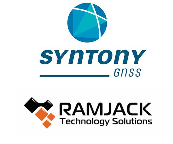
The ApusDuo project is the second generation of UAVOS’ HAPS solar airplane. (Photo: UAVOS)
UAVOS has joined the High Altitude Platform Station (HAPS) Alliance to promote the use of high-altitude solar-powered autonomous aircraft for facilitating global research missions, communication, connectivity, intelligence, surveillance and reconnaissance from the stratosphere.
UAVOS joined HAPS to collaborate with member companies towards accelerating the development and adoption of HAPS technology into the evolution of the high-altitude unmanned platforms market.
UAVOS’s HAPS knowledge is based on test flights for more than 1,000 hours of flight tests at altitudes of up to 66,000 feet (20,000 meters). The ApusDuo project is the second generation of UAVOS’ HAPS solar airplane.
HAPS platforms are autonomous, high-altitude, ultra-long endurance aircraft powered by solar energy. They are designed to boost internet connectivity worldwide, provide a long continuous monitoring of the Earth’s surface, create a network of autonomous repeaters and high-speed data signals. High-altitude unmanned platforms operate in the stratosphere, above ground infrastructure but below satellites, allowing for near ubiquitous coverage, which avoids ground clutter and significant latency issues.
The HAPS Alliance, originally an initiative from HAPSMobile and Loon, has members from the companies across the aerospace, technology and telecom industries.
Following the announcement that ION GNSS+ 2020 will be virtual only this year, GPS World has decided to cancel this year’s Leadership Dinner and Awards Ceremony, which would’ve been held Sept. 24 in St. Louis.
The GPS World Leadership Dinner and Awards Ceremony is held annually at the time of (although separately from and independent of) the ION GNSS+ conference. Four innovators in the fields of satellites, signals, services and products are honored with awards in front of an audience of nearly 150 PNT industry and research community VIPs.
“This was not a decision we took lightly as so many of us look forward to wrapping up the conference by honoring deserving colleagues over a nice meal followed by a fun activity,” said Marty Whitford, GPS World’s group publisher and editorial director.
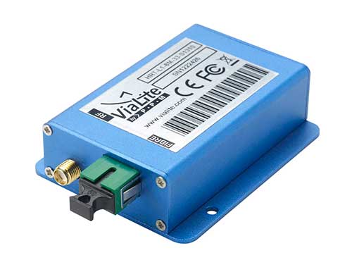
ViaLite has been asked to supply distributed GPS equipment for the NASDAQ stock exchange in New York for the first time.
Photo: ViaLite
ViaLite’s Distributed GPS System is being used to feed mission-critical timing and synchronization signals over optical fiber to multiple S650 GPS referenced NTP time servers.
Stock exchanges need to offer their clients the fastest possible trading speeds and, for this, their IT systems need to be provided with highly accurate timing signals, which can be obtained from GPS/GNSS satellite networks.
The equipment Vialite supplied included GPS lossless distributed multi-port fiber-optic links, supplied in OEM format to meet NASDAQ’s requirements.
“ViaLite was chosen for its performance attributes that are not readily available elsewhere in the RF over fiber market, as well as for its best in class quality, reliability and support,” said ViaLite director of sales, Craig Somach.
For more information on RF over fiber for data centers, stock exchanges and more, visit www.vialite.com.
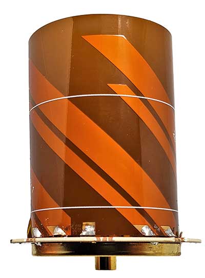
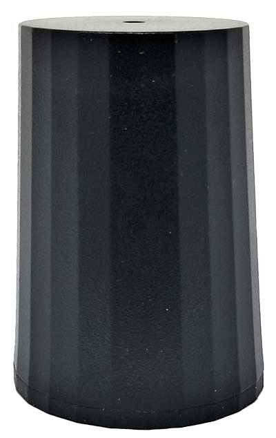
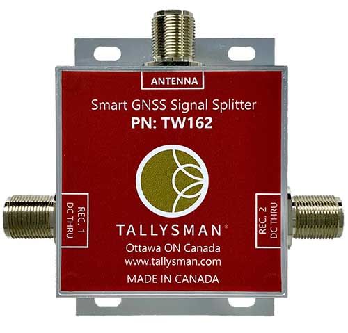
Tallysman Wireless Inc. has added two new models to its line of GNSS helical antennas.
Also new are two GNSS signal splitters.
New Helical Antennas
HC976 triple-band helical antenna with L-band, embedded version. (Photo: Tallysman)
The HC976 housed and HC976E embedded helical antennas are designed and crafted for high-accuracy positioning in a light and compact form factor, making them suitable for many applications:
autonomous vehicle navigation (land, sea and air)
handheld land survey devices
automotive positioning
GNSS timing
Both models support GPS/QZSS-L1/L2/L6, GLONASS-G1/G2, Galileo-E1/E6, and BeiDou-B1/B3 frequency bands.
Regional augmentation services supported include:
WAAS (North America)
EGNOS (Europe)
MSAS (Japan)
GAGAN (India)
high-precision L-band correction services
The key feature of the HC976 and HC976E is the support of QZSS-L6, Galileo-E6 and BeiDou-B3.
The HC976 is 44 millimeters (mm) wide and 62 mm tall, weighing only 42 grams.
HC976 triple-band helical antenna with L-band, housed version. (Photo: Tallysman)
It features a precision-tuned helical element that provides an excellent axial ratio and operates without the requirement of a ground plane, making it suitable for a wide variety of high-precision applications.
The HC976 also features a low-current, low-noise amplifier (LNA) and pre-filter to prevent harmonic interference from high-amplitude signals, such as 700 MHz band LTE and other nearby in-band cellular signals.
All Tallysman’s housed helical antennas are enclosed in a robust military-grade plastic enclosure. The antenna base has an integrated SMA connector, a waterproofing O-ring and three screw holes to enable secure attachment.
Weighing only 12g and measuring 39mm wide and 50mm tall, the lightweight HC976E embedded antenna supports all the features of the HC976. To facilitate installation of the HC976E, Tallysman provides an optional embedded helical mounting ring, which traps the outer edge of the antenna circuit board to the host circuit board or to any flat surface.
Tallysman also provides support for installation and integration of embedded helical antennas to enable successful implementation and to provide optimal antenna performance.
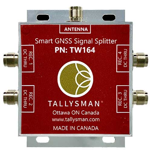
New GNSS Splitters
Photo: Tallysman
Tallysman’s two new Smart Power GNSS signal splitters improve GNSS service reliability.
GNSS is a critical component in safety, security, timing, and infrastructure applications, all of which require very high availability. Tallysman provides resilient, fault-tolerant Smart Power GNSS signal splitters that are essential to minimize service interruptions.
The design of first-generation GNSS signal splitters suffered from a single point of failure: only one attached receiver powered the splitter and the antenna. If this receiver failed or was unplugged, all attached receivers also failed.
Tallysman’s current-generation Smart Power GNSS signal splitters, TW162 (one antenna/two receivers) and TW164 (one antenna/four receivers), offer system redundancy and fail-over capability.
Photo: Tallysman
First, the splitter accepts power from all attached GNSS receivers; if one receiver fails, the next attached receiver automatically provides power to the splitter and antenna.
Second, if the antenna fails and does not draw current, it will provide the receiver powering the splitter with a current draw lower than 1 mA, indicating an antenna fault.
The Tallysman TW162 and the TW164 are professional-grade GNSS signal splitters that support the full GNSS spectrum: GPS/QZSS-L1/L2/L5, QZSS-L6, GLONASS-G1/G2/G3, Galileo-E1/E5a/E5b/E6, BeiDou-B1/B2/B2a/B3 and L-band correction service frequency band.
The TW162 and TW164 are packaged in a robust, compact, lightweight, and waterproof (IP67) corrosion-protected aluminum housing. They splitters are available with either TNC or type-N connectors. Two gain options are available: standard gain to compensate for signal-splitting loss and 10-dB gain.
The Sagar Defence Spectre UAV. (Photo: Sagar Defence Engineering)
Altitude Angel, an unmanned traffic management (UTM) technology provider, is partnering with Mumbai-based Sagar Defence Engineering Ltd. in BVLOS trials supported by India’s Directorate General of Civil Aviation (DGCA).
Together, Altitude Angel and Sagar Defence have been selected by India’s DGCA to carry out beyond-visual-line-of-sight (BVLOS) drone operations. The results of the trials will help define India’s regulatory framework for unmanned aerial vehicles (UAVs) in routine UAV deployment.
Altitude Angel’s GuardianUTM platform will enable BVLOS drone flights around a multitude of real-life scenarios including medical and cargo delivery, surveillance operations, survey & mapping, and search & rescue operations.
The Union Government has recently begun the process of granting regulatory permissions to the operation of drones for commercial purposes.
On participating in the BVLOS trials Richard Ellis, Altitude Angel’s chief business officer, said, “The potential for UAV use in India is immense so we’re excited to be partnering with Sagar Defence on these BVLOS trials. The ability to fly safely and securely BVLOS will unlock the potential of drones not just in India, but across the world. With Sagar, we’re very much looking forward to showcasing our proven technology to demonstrate the amazing use-cases of drones.”
Mridul Babbar, Sagar Defence’s business development head added, “Sagar Defence Engineering and Altitude Angel, two highly skilled teams, coming together for the BVLOS trials is a very strong partnership and one we’re thrilled to be part of. The combination of our UAVs and Altitude Angel’s world leading UTM platform will undoubtedly help advance the prospects of BVLOS flight across India and beyond.”
The BVLOS trials are scheduled to take place from August through to October 2020.
The trials will further build on trials Altitude Angel has been involved in this year. The company served as the lead and umbrella UTM for the Lake Kivu Challenge, part of the African Drone Forum, which took place on the shores of Lake Kivu, Rwanda, in January.
NXP and Auterion join forces to enable next-generation secure drone fleets with automotive certified solutions, high-reliability networking, and a scalable and open software platform.
Working together, the companies aim to develop highly reliable and advanced hardware and software solutions deployable in an unmanned aerial vehicle.
With the development of regulations and the increasing number of autonomous systems in the field, the requirement for components and software that are certifiable and the ability to deploy intelligence on the edge is becoming more and more important.
NXP provides semiconductor components and expertise leading to certifiable electronics solutions, including computational horsepower, secure element for encryption and authentication, and high reliability automotive networking.
Auterion is offering the hardware reference design and Auterion Enterprise PX4, the software for the flight controller and the mission computer to make drone fleets safe and fully integrated into workflows. Auterion is the largest contributor to PX4 and builds its software platform on open standards, ensuring that enterprises have access to a managed and tested distribution of the open source technology.
The partnership addresses the needs of the unmanned aerial vehicles industry for compatible hardware and software solutions that will help drone manufactures bring state-of-the-art products to market. The aim is to ensure that manufacturers have a streamlined path to certification and are connected to existing workflows.
“This partnership will enable the mobile robotics community with the components meeting quality specifications needed to ensure functional safety and security in drones and rovers based on reliable long life industrial and automotive parts and reference designs,” said Iain Galloway, Drone Program Lead, Systems Innovation, NXP. “We have been participating in the open source PX4 community for several years now and with this close relationship with Auterion, and Auterion Enterprise PX4, we are excited to work together to ensure these vehicles are prepared to meet current and future regulations and standards governing modular safe drone architectures.”
“Safety is the number one priority in commercial drone operations. NXP’s leading position as a semiconductor provider for safety-critical automotive applications is the perfect pairing for Auterion’s enterprise-grade drone software platform,” said Lorenz Meier, co-founder and CEO, Auterion. “Together, we will be able to provide integrated hardware and software solutions to the drone industry that combine high-performance compute with safety-first engineering.”
NXP and Auterion will collaborate on the core hardware and software components of an autonomous system, this includes, but is not limited to, the following topics:
Developing the next generation Auterion Skynode avionics module reference design, based on the latest Pixhawk autopilot Reference Standards and on the NXP i.MX 8M Mini as a companion computer, and on future components in this family.
Integrating navigation modules incorporating NXP Ultra-Wideband (UWB), automotive MCU, NFC and authentication for precision landing applications.
Developing Battery Management System (BMS) solutions based on the latest Pixhawk Smart Battery Standards.
Developing Automotive CAN and CAN-FD node solutions supporting popular software protocols such as UAVCAN and MRCAN for mobile robotics peripherals.
Collaborate in the data cybersecurity and drone regulatory space to help shape and meet future regulations.
Both parties will continue to support the PX4 open source community and upstream PX4 development, in an effort to enable the whole industry.
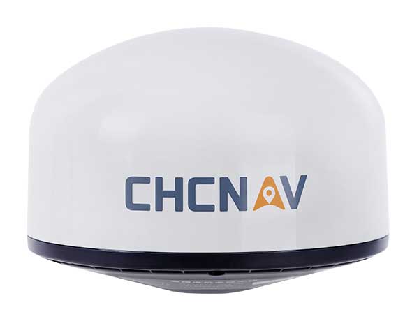
Designed for GNSS networks and monitoring applications
Photo: CHC Navigation
The AT661 geodetic antenna for GNSS networks or monitoring applications supports all current and future GNSS signals, including GPS, GLONASS, BeiDou, Galileo, QZSS, IRNSS, SBAS and L-band. The antenna features both high-gain LNA and wide beamwidth to provide excellent flexibility in applications requiring low-elevation satellite reception and high availability of GNSS signals, especially in obstructed situations. The accuracy of the antenna’s phase center reaches the millimeter level with extremely high stability and repeatability to ensure perfect processing of GNSS data regardless of the length of the baselines. The AT661 withstands all types of weather, including large temperature fluctuations, and is protected by a waterproof radome.
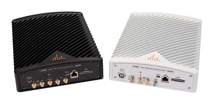
The ThinkRF R5750 Real-Time Spectrum Analyzer with GPS offers high spectral performance, low power consumption, and portability. The R5750 analyzer is built for outdoor, mobile and distributed deployment scenarios, including regulatory and intelligence monitoring, telecom deployment optimization, and RF application development. Users can deploy units in a variety of network architectures, analyze signals in real-time or later, and easily integrate with leading software applications to conduct demodulation or deeper analysis of signals up to 27 GHz. The R5750 analyzer includes embedded GPS for time and location data, and comes with an optional IP66 rating for increased durability and ruggedness in difficult environments.
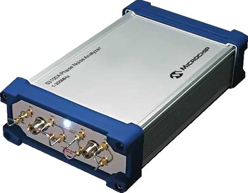
The 53100A Phase Noise Analyzer takes precise and accurate measurements of frequency signals, including those generated by atomic clocks and other high-performance frequency reference modules and subsystems. It combines timing technologies in a small, high-performance measurement instrument designed for engineers and scientists who rely on precise and accurate measurement of frequency signals generated for 5G networks, data centers, commercial and military aircraft systems, space vehicles, communication satellites and metrology applications. Up to three separate devices can be tested simultaneously using a single reference, enabling higher capacity for stability measurements.
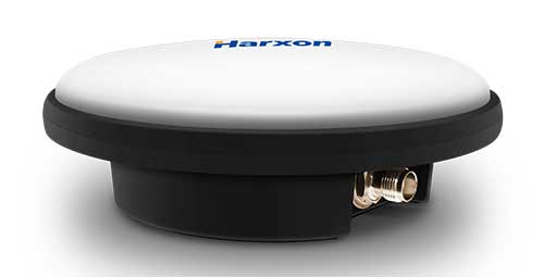
The IP69K ruggedized HX-CVX600A antenna provides end users with millimeter accuracy, durability and productivity. The antenna is designed for applications subject to high shock and vibration environments such as machine control. Integrated with reliable signal tracking and strong anti-interference performance, the Harxon HX-CVX600A offers full support for reliable and consistent satellite signal tracking, including GPS, GLONASS, Galileo, BeiDou, QZSS, IRNSS and SBAS, as well as L-band correction services. Its stable phase center adopts multipoint feeding technology, exceptional low-elevation satellite tracking with symmetric radiation patterns, high gain with ultra-low signal loss, as well as outstanding wide-angle circular polarization. The aerodynamic enclosure withstands exposure against dust, rain, splash or sunlight.
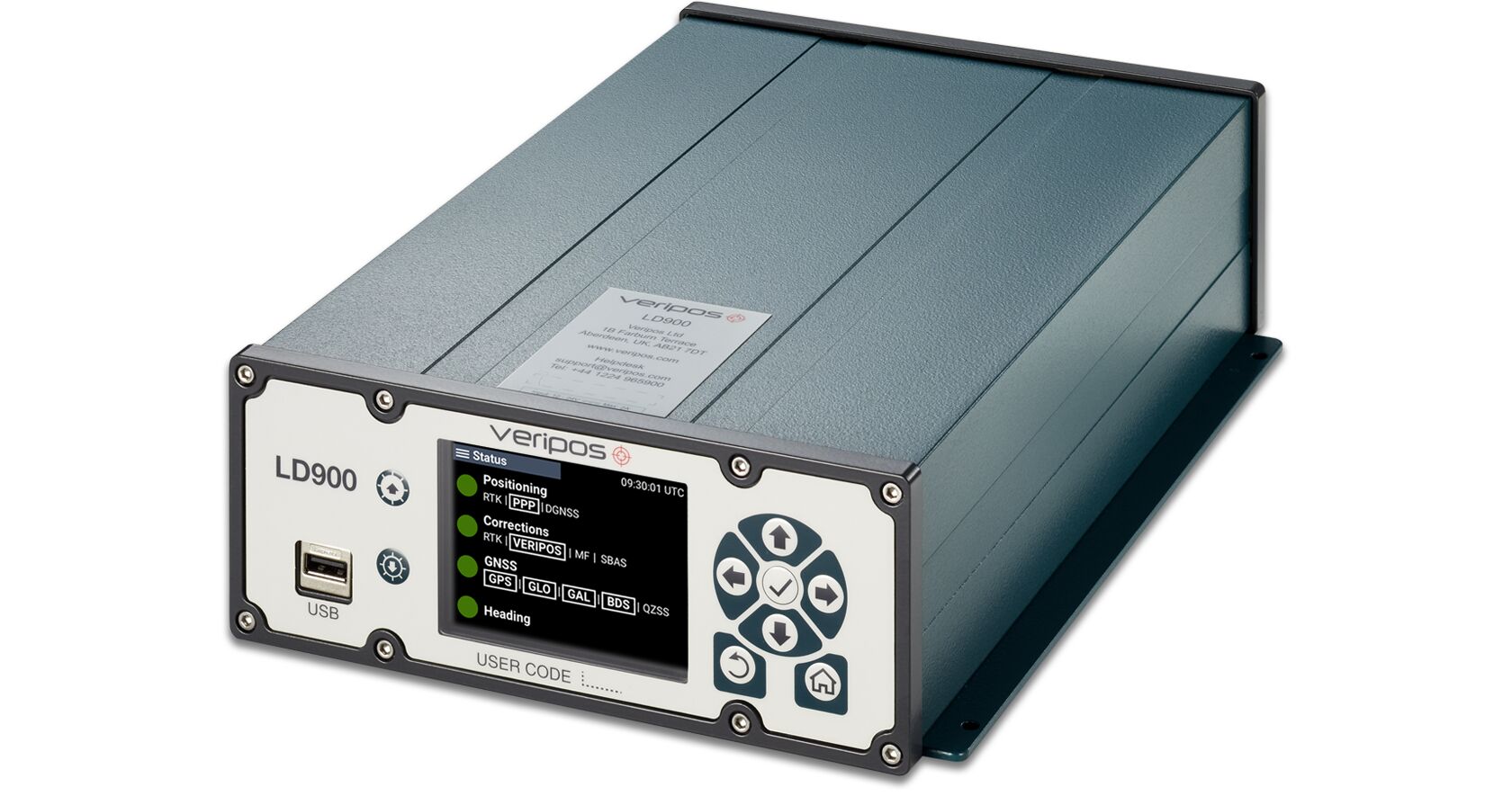
The LD900 is a quad-band GNSS receiver capable of tracking GPS, GLONASS, BeiDou, Galileo and QZSS constellations to provide reliable and accurate positioning. The LD900 also receives L-band signals on multiple channels, providing access to Veripos’ worldwide independent correction services. Using the independent L-band RF input on the LD900 allows the connection of a dedicated L-band antenna ensuring optimal reception of correction services, especially at high latitudes. Veripos provides accurate and reliable positioning for all marine applications via their redundant positioning and multi-frequency precise point positioning (PPP) Apex and Ultra services. The Apex5 correction service utilizes all GNSS constellations delivering 5cm positioning accuracy for use in the most demanding offshore applications. Real-time kinematic (RTK) corrections can be utilized by the LD900 for applications where this service is required. The intuitive color display and navigation menu makes setup, configuration and system status monitoring simple. The display also helps troubleshoot issues with the LD900, allowing faults to be quickly diagnosed and resolved. The LD900 can also be configured remotely through the Veripos Quantum software.
The edge-to-cloud IoT platform Particle is offering a new tracking system that allows organizations to track the locations of a wide variety of mobile assets. Particle’s Tracker system-on-module (SoM) provides a powerful GNSS, microcontroller and advanced peripherals in a compact form factor. Tracker SoM serves as a starting point for organizations that require a tailored tracking solution for sophisticated applications, as well as a fully certified foundation for OEMs developing commercial products. All of the company’s tracking solutions come with a high-gain GNSS antenna accurate to 1.8 meters. The field-ready solution is configurable and can track the real-time location of critical assets and capture additional intelligence via sensor data including temperature and acceleration as well as remotely controlled mobile equipment and vehicles.
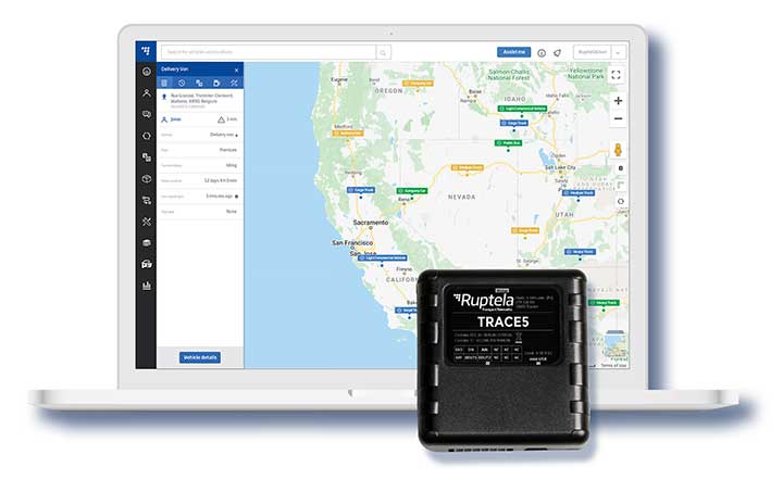
Designed in Europe, now available in North America
Photo: Ruptela
The Trace 5 plug-and-play GPS-based automatic vehicle location (AVL) tracker and multifunctional fleet management platform TrustTrack provide a ready-to-use telematics solution. The Trace 5 GPS tracker has LTE Cat M1 (4G) connectivity and an integrated battery. TrustTrack is an advanced telematics platform for businesses to manage transport resources. It connects dispatchers and drivers and enables real-time monitoring and drivers’ management. It also generates trip reports.
The HawkEye 5500 is the a dual-mode real-time tracking and vehicle management system that supports Iridium, GPS and 2G/3G/LTE. A GNSS/Iridium antenna is included in the kit. The HawkEye 5500 offers full integration of on-board systems, support for both light and heavy-duty vehicles, two-way messaging, a remote emergency switch, collision detection, audible alerts, RFID and Bluetooth driver identification and customizable application integration. It provides global always-on coverage with high-resolution tracking and communication. Users can customize reporting rates based on movement or location and provide driver feedback when safety violations occur. All operations are tracked via Blue Sky Network’s portal, SkyRouter, which allows for effective high-security command and control of fleets anywhere on the planet.
For infrastructure, mining, forestry, construction
Photo: Kaarta
The Stencil Pro, now in beta testing, is a professional-grade mobile mapping platform with dimensional and visual fidelity. The all-in-one system can scan, process and view captured data in real time. It offers panoramic high-definition 4K imagery and colorized point clouds, and is optimized for both indoor and outdoor lighting. Its simultaneous localization and mapping (SLAM) capabilities enable it to operate in GNSS-denied areas such as indoor, underground, under thick canopy, or in urban canyons. However, it is also fully geo-enabled with an integrated Trimble BD-990 receiver, AV-28 antenna and a range of other third-party GNSS antennas. It supports accuracy enhancements through live RTK/NTRIP processing as well as PPK corrections. GNSS positioning data is used to align and geo-register data for accuracy. The onboard GNSS and color cameras are fully integrated into real-time capture. If a colorized point cloud is not required, or GNSS is not available, reliance on other sensors is seamless.
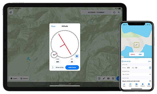
Touch GIS is a powerful mobile app for field data collection and visualization. Version 1.3 features a digital clinometer to assist field geologists in recording strike and dip readings as well as a new attitude attribute type, which makes it easy to record and display these readings on the map. Touch GIS has powerful file support for industry-standard types, offline mapping capabilities, and accurate drawing tools for points, lines and polygons.
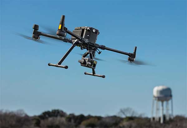
For precise aerial inspections and data collection
The Matrice 300 RTK UAV. (Photo: DJI)
The Matrice 300 RTK is DJI’s most advanced commercial drone platform to date. It integrates modern aviation features, advanced artificial intelligence capabilities, a six-directional sensing and positioning system and a UAV health management system. It has 55 minutes of flight time. The drone platform has AES-256 encryption and an IP45 weather-resistant enclosure. A built-in all-new OcuSync Enterprise transmission system provides a triple-channel 1080p video transmission signal reaching up to 15 kilometers away. The M300 RTK can support up to three payloads simultaneously and up to a total payload capability of 2.7 kg.
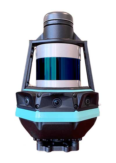
Robust positioning in demanding industrial environments
Photo: Septentrio
The AsteRx-i D UAS combines centimeter-level positioning with 3D orientation, enabling automated navigation of aerial drones and robots. It is compact and lightweight, with a high-performance inertial measurement unit from Analog Devices integrated directly into the receiver board. Its small form-factor combined with exceptionally low power consumption results in extended battery life and longer flight times. Both single-antenna and dual-antenna versions are available. The single-antenna version provides a lightweight solution optimizing the system size, weight and power (SWaP). The dual-antenna version is designed for machines that need reliable heading from the start.