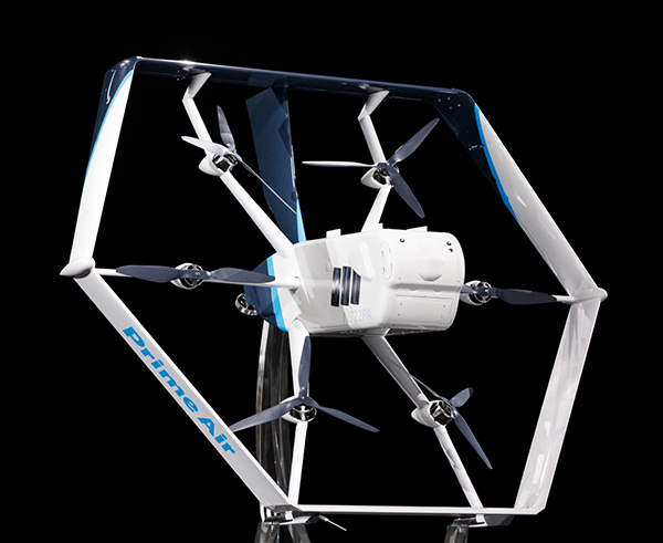
Amazon’s latest delivery drone design was unveiled in June 2019. (Photo: Amazon)
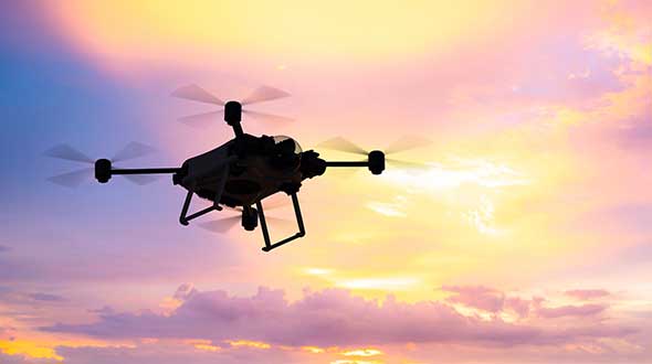
Amazon has received U.S. Federal Aviation Administration (FAA) approval to use drones to deliver packages, which Amazon says will reduce package delivery time to as little as a half-hour.
The approval will give Amazon broad privileges to “safely and efficiently deliver packages to customers,” the FAA said.
Amazon joins UPS and Alphabet-owned Wing, which previously won FAA approval for their drone delivery operations.
The approval falls under Part 135 of FAA regulations, which regulates package delivery by drone. All part 135 participants must go through a five-phase process for certification.
“The FAA is encouraging innovation through the Unmanned Aircraft Systems (UAS) Integration Pilot Program (IPP) by working with industry, state, local, and tribal governments to realize the benefits of drones, while informing future rules and regulations,” according to the FAA.
“Participants in these programs are among the first to prove their concepts, including package delivery by drone through part 135 air carrier certification. Part 135 certification is the only path for small drones to carry the property of another for compensation beyond visual line of sight.”
Amazon said it will use the FAA’s certification to begin testing customer deliveries. The company said it went through rigorous training and submitted detailed evidence that its drone delivery operations are safe, including demonstrating the technology for FAA inspectors.
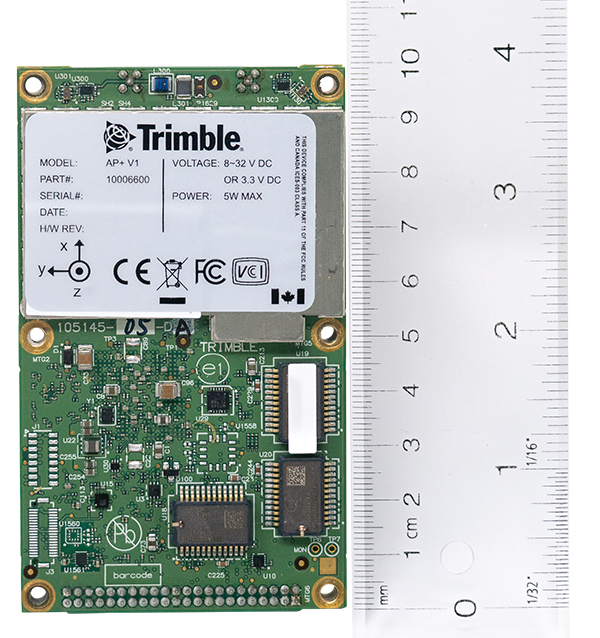
Applanix, a Trimble company, has introduced the Trimble AP+ Air OEM solution for direct georeferencing of airborne sensor data.
The solution enables users to accurately and efficiently produce maps and 3D models without the use of ground control points.
The Trimble AP+ Air is a powerful solution for manned platforms, yet small enough for use on unmanned aerial vehicles (UAVs). It is also compatible with virtually any type of airborne remote sensor, including photogrammetric cameras, lidar, hyper and multispectral cameras, and synthetic aperture radar.
Comprised of next-generation compact, low-power hardware, the Trimble AP+ Air features dual embedded survey-grade GNSS chipsets, an onboard inertial measurement unit (IMU), an external IMU, and the all-new Applanix IN-Fusion+ GNSS-aided inertial firmware. It is configurable to support the direct georeferencing accuracy demands of low-flying UAVs to high-altitude manned platforms.
“We have taken the most advanced features of Applanix direct georeferencing and Trimble GNSS technology and packaged them into a powerful new, compact and versatile solution,” said Joe Hutton, Applanix’ director of inertial technology and airborne products. “It provides the flexibility required by systems integrators to embed a single hardware solution that can then be configured to meet the different direct georeferencing needs of a specific sensor type, whether flown on a UAV or manned aircraft. It truly is an ‘integrate once, use many times’ solution.”
The Trimble AP+ Air is fully supported by the Applanix POSPac MMS post-processing software, which features CenterPoint RTX post-processing for centimeter-level positioning anywhere in the world without the need for base stations. These capabilities make the solution ideal for integrators to produce a highly efficient airborne mapping system.
For lidar integrators, the Trimble AP+ Air is compatible with the POSPac MMS LiDAR QC Tools for computing boresight as well as adjusting the relative accuracy of the POSPac trajectory being used to generate the point cloud. For integration with cameras, the solution is supported by the POSPac MMS Photogrammetry Tools for computing boresight and performing camera IO quality control.
The Trimble AP+ Air OEM solution and POSPac MMS are available through Applanix sales channels.
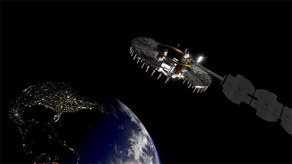
Satellite NTS-3 above Earth. (Illustration: Lt. Jacob Lutz, AFRL Space Vehicles Directorate)
L3Harris Technologies is on track to begin building the U.S. Air Force’s first Navigation Technology Satellite-3 (NTS-3) after completing the program’s critical design review.
According to L3Harris, it will integrate the program’s experimental payload with an ESPAStar Platform, planned for launch in 2022. The system is designed to augment space-based position, navigation and timing (PNT) capabilities for warfighters.
The NTS-3 payload features a modular design, and the experiment will demonstrate capabilities that can be accomplished through a stand-alone satellite constellation or as a hosted payload.
“Collaboration with our customers has enabled us to move rapidly through important milestones to design this experimental satellite,” said Ed Zoiss, president, space and airborne systems, L3Harris. “Our goal is to deliver new signals to support rapidly evolving warfighter missions.”
The Space Enterprise Consortium selected L3Harris for the $84 million contract in 2018 as the prime system integrator to design, develop, integrate and test NTS-3. The NTS-3 will examine ways to improve the resiliency of the military’s PNT capabilities. It will also develop key technologies relevant to the GPS constellation, with the opportunity for insertion of these technologies into the GPS IIIF program, L3Harris said.
The program is a collaboration with the Air Force Research Laboratory, Space and Missile Systems Center, U.S.Space Force, and Air Force Lifecycle Management Center.
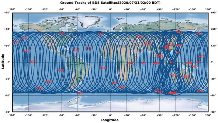
Current u-blox GNSS platforms — from u-blox M8 and beyond — support the recently completed BeiDou navigation satellite system modernizations, improving the availability of GNSS positioning services.
The opening ceremony of the BeiDou-3 global navigation satellite system (GNSS) was held in Beijing on July 31, officially celebrating the expansion of coverage offered by the critical Chinese space infrastructure to a global user base.
As a global supplier of GNSS positioning and wireless communication technologies, u-blox has been driving technological innovation and deeply involved in the Chinese market for many years.
Tests conducted across China and Europe have shown that including the BeiDou system can improve the positioning accuracy of GNSS receivers when multiple navigation satellite systems are tracked concurrently. When signals are partially obstructed, positioning accuracy can be significantly improved by incorporating the BeiDou system.
Data shows that in 2019, the overall output value of the Chinese satellite navigation and location service industry reached nearly 345 billion yuan, an increase of 14.4% over 2018, with the output value expected to exceed 400 billion yuan in 2020.
Graphic: China Satellite Navigation System Management Office Test Evaluation Research Center
Additional Services Provided by BeiDou
The BeiDou system provides a suite of additional services, including satellite and ground-based augmentation services, precise single-point positioning, precise timing and global short message services, laying a solid foundation for BeiDou’s ubiquitous navigation and tracking applications.
Applications of GNSS technology continue to diversify, leveraging the all-weather, all-time, tracking, navigation and timing services it offers. GNSS technology is penetrating deeper into traditional industrial verticals, such as agriculture, forestry, animal husbandry and fishery, power and energy, as well as in railway and air transportation, including their infrastructure construction and management.
At the same time, GNSS technology has become an indispensable and “smart” factor in emerging application fields such as the internet of things and the “internet of vehicles,” as well as in innovative applications such as autonomous driving, automatic parking and automatic logistics, and is now commonplace in many industrial and consumer use cases.
“U-blox has been closely following the modernization of the BeiDou navigation system and is ready to work with partners in various industries to promote the expansion of industry applications, expand emerging markets and jointly create a green industry ecosystem,” said Hamilton Chen, China country manager at u-blox.
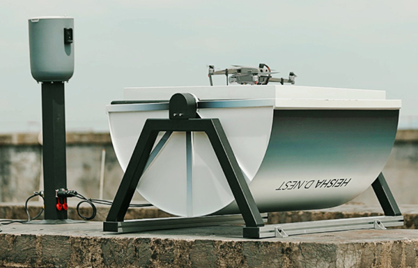
Heisha, a drone-charging solution and unattended drone system provider, has launched a new drone-in-the-box hardware platform, D.NEST.
D.NEST is an automatic drone-in-the-box hardware platform compatible with DJI drones, open-source project drones and vertical take-off and landing (VTOL) aircraft.
Based on Heisha’s third-generation charging pad C500, D.NEST is a reliable and stable automatic drone charging solution. Equipped with a built-in AI computer, remote-control base and local router, D.NEST is easy to maintain and redevelop, according to the company. Additionally, the hardware platform can be a data center and control center for different robots.
Heisha operates an open-source interface API and SDK, making it flexible. Designed for use with the DJI Mavic and Phantom series, D.NEST can also be customized for use with the M200, M210, M300, M600, open-source UAVs and VTOL fixed-wing UAVs.
Equipped with the 5-in-1 PCB control K100 and industrial-level materials, Heisha also provides a useful, stable and cost-effective drone-charging platform.
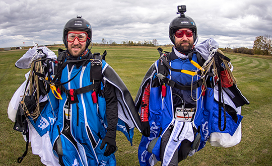
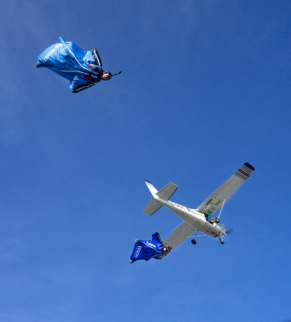
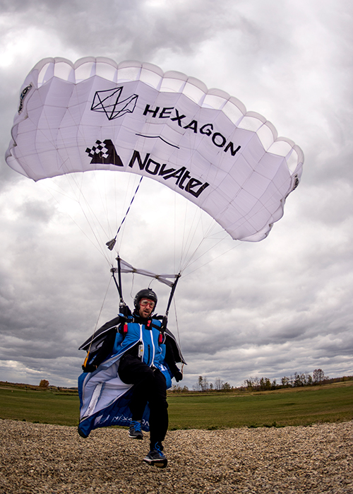
An applications engineer and his sky-jumping bud don wingsuits to test a NovAtel GNSS receiver integrated with an Epson IMU.
In September 2019, a specialized team assembled at an airstrip outside of Edmonton, Alberta, Canada. Their mission: Put the Hexagon | NovAtel PwrPak7D-E2 enclosed receiver through tricky test procedures that involved jumping out of an airplane at 10,000 feet.
Taking the NovAtel SPAN receiver to the skies was the brainchild of Andrew Levson, who is both a NovAtel engineer and a skydiving aficionado. He proposed using a wingsuit to test the receiver’s positioning accuracy.
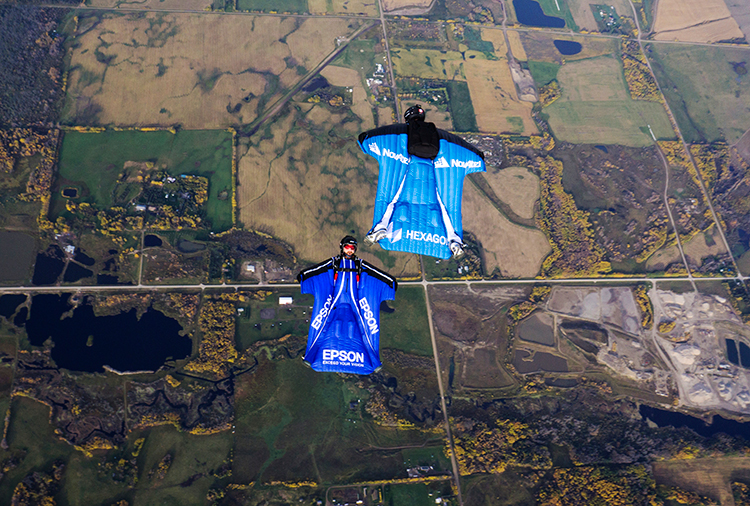
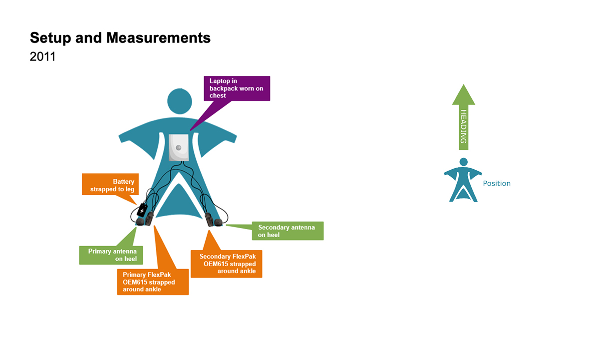
The first wingsuit dive took place in 2011, with NovAtel’s OEM615 receiver and ALIGN heading technology.
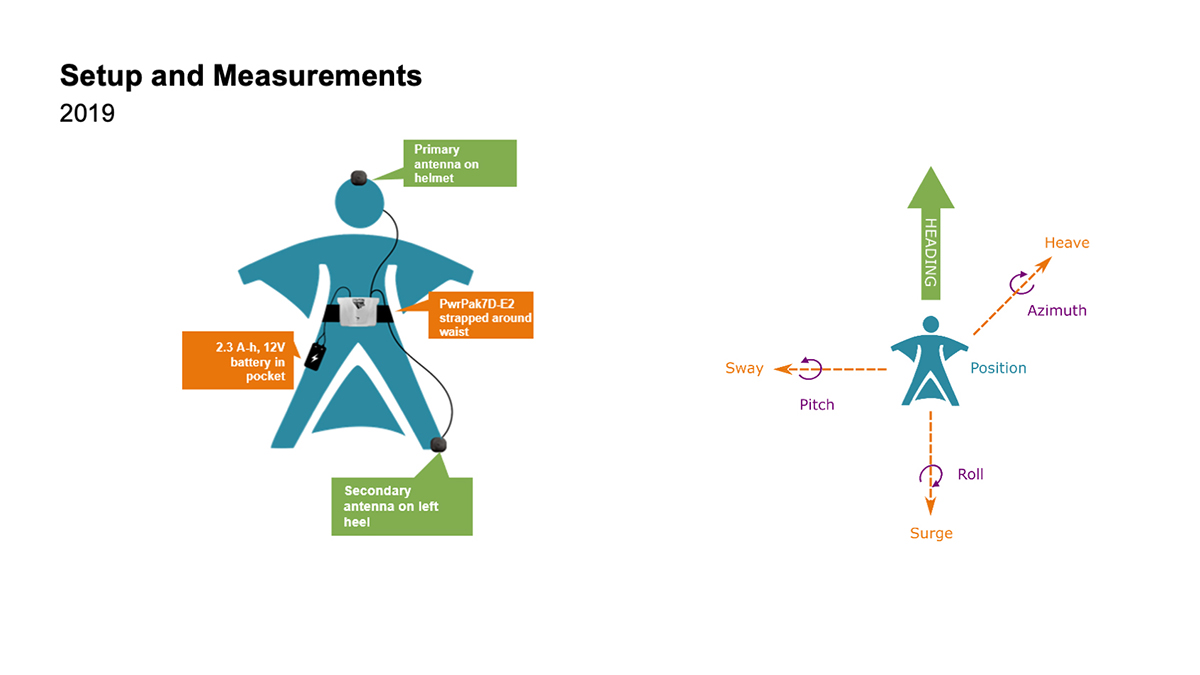
This time, the engineers aimed to test both NovAtel’s GNSS receiver featuring SPAN tightly coupled GNSS+INS functionality and its new companion, the Epson G370 inertial measurement unit (IMU). Both are packed in the PwrPak7D-E2 to provide uninterrupted positioning even in GNSS-denied environments.
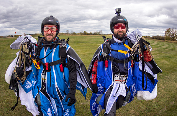
Wingsuit jumpers Andrew Levson (right) and Blair Egan suit up for the NovAtel tests. (Photo: NovAtel)
“We chose to revive the project, given that equipment has evolved with more comprehensive capabilities,” said Patrick Casiano, manager of Product Management and Applied Technology, NovAtel. “Between 2011 and 2019, we could significantly reduce the payload while increasing value in the data.” In 2011, NovAtel was only able to monitor Levson’s heading. In 2019, the team captured heading, azimuth, pitch and roll measurements.
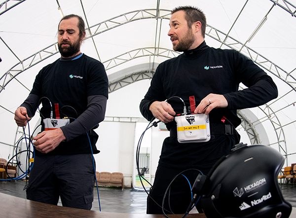
“We wanted to prove that our equipment can work in a high-dynamic environment, which isn’t necessarily ideal conditions for collecting positioning data,” explained Kiera Fulton, associate product manager, Enclosures and Post-Processing Software, NovAtel. “By proving our products work in a less-than-ideal environment, we exemplify how robust our solutions are.”
Photo: NovAtel
Test Preparation
For the 2019 test, the team chose to gather attitude data. The team also asked Levson to perform specific skydiving maneuvers to rigorously test the positioning solution. “Rather than performing just a simple flight to the ground, we wanted to challenge the solution to reveal more,” Casiano said.
The test was not easy to implement. A lot of behind-the-scenes planning and preparation went into the project. Plus, unforeseen factors made the test more challenging, Fulton said, such as logistics and weather.
“The skydivers require specific weather conditions in order to jump safely,” Fulton said. “Considering how quickly the weather can change here in Alberta, the time windows in which the skydivers could safely jump were few and far between. We pulled through regardless of these adversities.”
When the day of the jump came, the skydivers jumped five times — as many jumps as the weather would permit. “Theoretically, one jump is enough,” Casiano explained. “But as engineers, we always want to have more data to work with.”
2011 wingsuit jump setup. (Image: NovAtel)Wingsuit Jumps Compared: Because of the PwrPak7D-E2’s small size yet strong processing power, Levson required fewer devices in 2019 than in 2011, when he was equipped with two receivers, two antennas, a laptop and a battery. The amount of positioning data also increased. (Image: NovAtel)
High-Flying Maneuvers
The skydivers executed four maneuvers during their jumps.
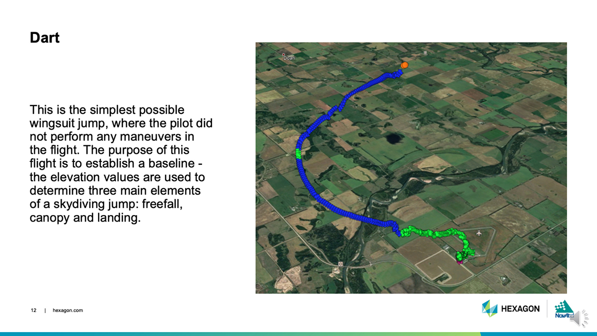
DART: This simple jump established a baseline for more complex maneuvers to follow. (Photo: NovAtel)
Dart. The skydivers first performed a straight jump, which the team called the Dart. The data from this jump provided a baseline for analyzing the positioning and attitude data.
“This was more important for the attitude analysis, as we have never collected inertial data in a skydiving jump before,” Fulton said.
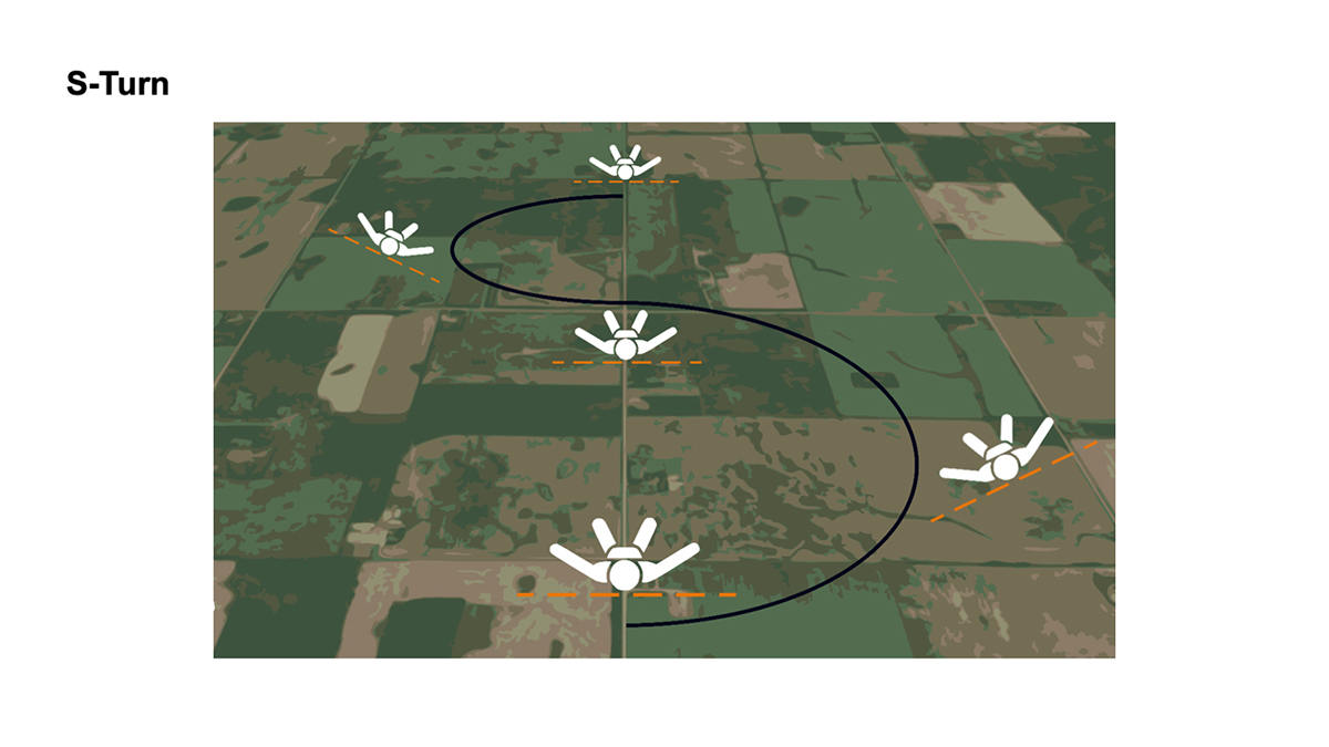
S-Turn: One of three completed maneuvers. (Image: NovAtel)
S-Turn. Next came the S-Turn. In this maneuver, Levson weaved from side-to-side to test how the equipment handles agile movements.
For the S-Turn, the engineers anticipated seeing the biggest changes in roll. “We were pleasantly surprised to see that the S-Turn is detectable in the azimuth data as well, indicating high correlation between roll and azimuth in a skydiver’s movements,” Fulton said.
The maneuver revealed that when Levson rolls, his body is using less surface area for wind resistance. As a result, he was falling to the ground faster, which then meant the dataset is shorter.
“This became another challenge during data processing, as the free-fall portion of the datasets were now becoming less than 3 minutes in duration,” Fulton said.
Data from the S-Turn also revealed the effect of crosswinds, which is detectable in the data.
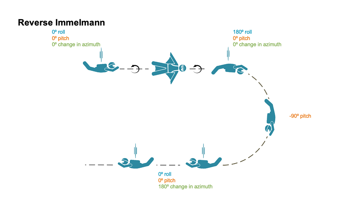
Reverse Immelmann: How the intricate maneuver works. (Image: NovAtel)
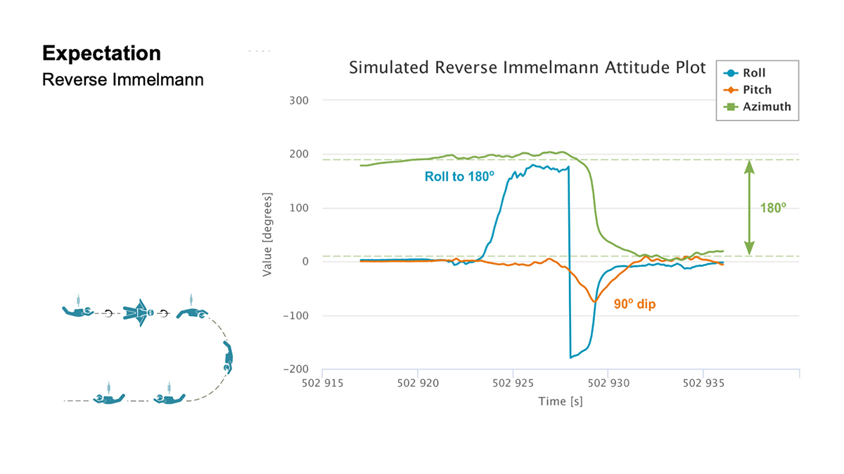
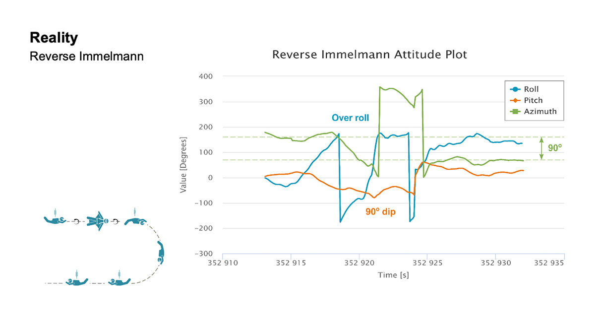
Reverse Immelmann. The third maneuver was the Reverse Immelmann. Levson flipped onto his back, began a downward turn until perpendicular to the ground, then leveled off, traveling in the opposite direction from where he began.
This complicated exercise provided data for all aspects of an attitude solution — roll, pitch and azimuth. By comparing the expected and real data, the team found several places where the maneuver wasn’t performed perfectly.
“There are many challenges once in the air that would have caused Levson to deviate from the trends in the data that we expected,” explained Fulton. “This is where we realized that our solution was working much more to evaluate the skydiver, rather than using the wingsuit to evaluate our product.”
Casiano agreed. “As a whole, the PwrPak7D-E2 was telling a story about Andrew’s flight,” he said.
The team also wanted to have the skydivers try a Cobra — a maneuver from aerobatics where an airplane momentarily lifts it nose and stalls — but time constraints prohibited it.
“If we had gotten this [a Cobra] recorded, it would have been detectable in the pitch and horizontal velocity data,” Fulton said. “Who knows what other findings we would have come across in this data!”
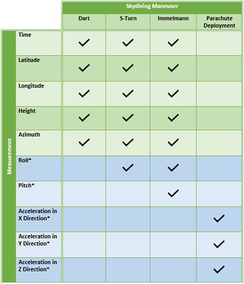
Measurement matrix: The asterisks (*) denote data values that can only be measured with an IMU. (Chart: NovAtel)
Applications
All these tests, of course, are designed to apply to real-world applications where the PwrPak7D-E2’s capabilities are used in dynamic environments.
For instance, an unmanned aerial vehicle (UAV) needs a feedback mechanism that tells the user whether it is moving or hovering. “In the wingsuit project, we proved that crosswind can be detected,” said Casiano. “This is an important finding for UAV applications, since a feedback loop from the PwrPak7 and the SPAN system can help rectify movement from external forces with counter propulsion to stay still. The PwrPak7D-E2 enclosures allow a data rate of up to 200 Hz, meaning you can capture motion with more detail.”
The PwrPak7D-E2 also works well for any black-box application where users want to record with the push of a button.
Inside the PwrPak7D-E2
Photo: NovAtel
The PwrPak7D-E2 is an all-in-one product. Its components are designed to work together seamlessly to provide positioning data, housed in NovAtel’s OEM7 firmware.
GNSS receiver card used to capture positioning data
Dual-antenna capability to provide accurate heading
Epson IMU to record attitude and motion
On-board logging to eliminate the need for constant monitoring on a PC
Post-Processing
Preparation enabled the team to process the data on site. The on-board logging feature on the PwrPak7D-E2 eliminated the need for constant monitoring during data collection. The unit is pre-configured so that at the time of the jump, Levson only needed to push a button for the unit to start collecting data.
Once the pair of skydivers landed, the ground team offloaded the data for processing, similar to using a memory stick, and moved it to a laptop computer.
“We pulled raw measurement data from the receiver and processed those measurements into position and attitude information,” Fulton said.
It took about 30 minutes to determine whether the dataset was viable. Later processing back in the office generated the charts such as those below.
Expectation: For both the S-Turn and Reverse Immelman maneuvers, a simulated plot was generated at the office to better understand the inertial data produced from the actual wingsuit jumps. (Chart: NovAtel)Reality: This chart shows the actual data. (Chart: NovAatel)
Dynamic Environments
Photo: NovAtel
The PwrPak7 series can be used in many environments in the automotive, agriculture, marine, defense and UAV fields.
“We are constantly trying to find ways to apply this product to other applications and industries,” Fulton said. “With more testing, we keep finding that the PwrPak7 can be used to solve more challenges.
“We want to push the boundaries of our products. True innovation comes from challenging yourself and hovering outside your comfort zone,” Fulton said. “For this project, we are more than satisfied with the results we found. In order to further challenge ourselves and this product, we look forward to applying the PwrPak7 in more scenarios.”
“The PwrPak7 is a robust unit that sets us up for more exploration,” Casiano said. “We are always looking for more challenges to put this unit through to see how the PwrPak7 can further help solve our customer’s problems.
But will there be more skydiving for NovAtel in Levson’s future?
“We could always revisit the skydiving project in another nine years,” Casiano said. “But who knows how the technology will evolve by then?”
Post flight: Blair Egan (right) and Andrew Levson back on Earth. (Photo: NovAtel)
What it feels like to take the plunge
For those of us who have never jumped out of a plane, engineer and skydiver Andrew Levson provides insight.
“It’s not as scary as people think. Because the plane is moving fast, it’s mostly just windy and loud. You don’t get that roller coaster type feeling; in fact you don’t feel like you are even falling — freefall feels more like floating than falling. You definitely wouldn’t know you are flying at speeds over 100 mph.
“When you are climbing out of a plane, there is nothing else on your mind aside from the jump you are about to do. It is pure freedom, and there is often no stress, just a sense of peace and an intense focus on your plan for the jump. Once you get out of the aircraft, you get to fly your body in the way that you want to — most people only know of the position of falling with your body arched and belly toward the ground, but there are many different ways you can orient your body. Some of the lesser known ways to fly your body include your arms and legs spread out while flying a wingsuit (with your belly or back toward the earth) or flying with your head pointing straight at the ground.
“When you skydive, you get to explore the sky with your friends, which is an amazing and unique experience. During a skydive, it is common to experience an ultra-focus during the jump — time slows down a bit and you can see and feel things that are seemingly beyond your typical capability.Many people are amazed at how much skydivers are able to do in the short period of time that a single skydive lasts — about a minute for regular skydives and about two or three minutes when flying a wingsuit.”
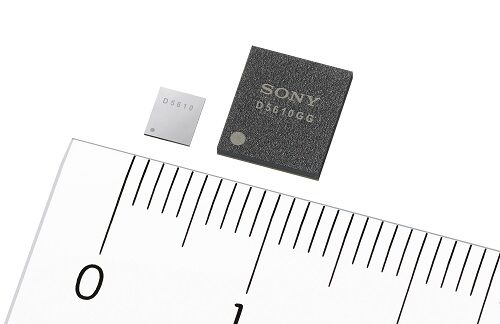
Sony GNSS receivers. (left) CXD5610GF, (right) CXD5610GG. (Image: Sony)
Sony Corporation plans to release a high-precision GNSS receiver for use in internet of things (IoT) and wearable devices. The new receivers have low power consumption for dual-band positioning operation — as little as 9 mW.
Increasing use of IoT and wearable devices that utilize location information has resulted in growing demand for GNSS receiver large-scale integrated circuits (LSIs). Precise positioning and reliable communications must be ensured to maintain proper operation of IoT and wearable devices, which are being used even in difficult communication environments and unstable conditions, such as multipath propagation situations caused by reflection off the ground or nearby buildings or the effects of the swinging of the arms when attached to a person’s wrist.
Additionally, device size constraints necessitate a compact battery, whereas satellite signal reception and positioning when using GNSS functionality typically consumes a lot of power, resulting in poor battery life.
The new LSIs support not only the conventional L1 band reception, but also L5 band reception, which is currently being expanded across GNSS constellations, thereby making them capable of dual-band positioning. Sony’s original algorithms enable stable, high-precision positioning even under the difficult conditions unique to wearable devices.
Also, the use of Sony’s original high-frequency analog circuit technology and digital processing technology delivers low power consumption during continuous positioning for dual-band reception operation.
The new LSIs will drive greater opportunities to develop new products and services such as smartwatches and other wearable devices that cannot use external power supplies, as well as IoT devices used for applications such as trackers. They also show promise in a wide variety of applications which require precise positioning and stable communications, such as automotive services.
High-precision, stable positioning via dual-band operation
Compared with the L1 band, the new signal method used in the L5 band employs signal units that are 10 times narrower to measure the range between the GNSS satellite and receiver, improving positioning precision and amplifying the transmission power from the satellite, resulting in high-precision, high-sensitivity positioning.
Quick, accurate GNSS signal reception via Sony’s original algorithms enables positioning that is more stable than conventional products even in changing reception environments, such as obstructing from buildings when on the move and acceleration of wearables due to swinging of the arms. This also leads to quick positioning time even from cold starts, which require more time.
Additionally, Sony’s original digital signal processing technology enables countermeasures against the performance degradation caused by radio interference from aircraft communications as well as spoofing attacks and other issues, thereby improving resistance to interference.
Low power consumption and high sensitivity are delivered by Sony’s original analog circuit technology, which enables low-voltage operation, as well as digital circuits and software algorithms that enable software processing via low clock frequencies. This innovative design keeps power consumption to only 9 mW, the lowest in the industry, when simultaneously receiving signals in both the L1 and L5 bands.
Built-in memory
The new LSI’s feature built-in non-volatile memory for storing firmware, etc. This design makes it possible to update the firmware without adding externally mounted memory and contributes to a more compact design for IoT and wearable devices by saving space. It also makes it possible to complete data-processing in the products, resulting in low power consumption and improved access speed.
Key specifications
Power Consumption
1.5 GHz/1.2 GHz simultaneous reception
9 mW
11 mW
1.5 GHz reception
6 mW
7 mW
1.2 GHz reception
7 mW
8 mW
Hot Start Sensitivity: –163dBm
Tracking Sensitivity: –167dBm
Hot Start Initial Positioning Calculation Time: Less than 1 second (at -130dBm)
User Interface: UART, I2C, SPI
Package: XFBGA 54 pin, LFBGA 72 pin
External Dimensions (LWH): 3.2×3.7×0.5 mm; 7.0×8.0×1.4 mm
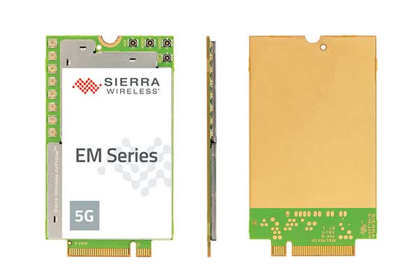
With support for mmWave, Sub-6 GHz and LTE, Sierra Wireless modules will enable original equipment manufacturers to securely deploy 5G worldwide
Photo: Sierra Wireless
Sierra Wireless is now offering its EM919x 5G NR Sub-6 GHz and mmWave embedded modules, which include an integrated GNSS receiver.
Based on the industry-standard M.2 form factor, the 5G modules will enable original equipment manufacturers (OEMs) to deploy secure connectivity worldwide at the highest possible speeds with ultra-low latency for mobile computing, routers, gateways, industrial automation, and many new Industrial IoT applications.
With support for mmWave, sub-6 GHz and LTE, as defined by the 3GPP Release 15 standard, Sierra Wireless’ 5G modules will power next-generation devices that deliver high-bandwidth, low-latency applications.
Applications for the module include private networks, enterprise networking, edge processing, live streaming, video security, e-gaming, smart factories, robotics, drones, virtual reality and machine learning.
Allied Telesis, Dynabook, LiveU, NEC Personal Computers and Panasonic are among the OEMs designing their 5G platform to launch with Sierra Wireless’ EM919x modules.
Module versions available
The EM9190 5G NR Sub-6 GHz and mmWave embedded module delivers high 5G speeds. Along with the GNSS receiver, the module has automatic 4G and 3G fallback and FCC certification for CBRS networks to provides reliability, security and flexibility for Industrial IoT designs.
The EM9191 5G NR Sub-6 GHz module is also available in M.2 form factor, providing a simple upgrade path to mmWave, as well as the EM7690 LTE Cat-20 module to help facilitate the migration and differentiation between 4G LTE and 5G.
Sierra Wireless’ EM919x modules are built on the Qualcomm Snapdragon X55 5G Modem-RF System.
“5G is the most technically challenging evolution in the history of wireless, particularly because of the introduction of mmWave,” said Larry Zibrik, Vice President, 5G & Embedded Broadband, Sierra Wireless. “Sierra Wireless has delivered industry-leading embedded modules, beginning with the first generation of cellular data technologies, and we’re the only partner with the experience to help our customers navigate the complexities of 5G. Industry leaders trust Sierra Wireless to help them get to market on time with secure 5G connectivity, and to invest in the expertise required to enable future key features, such as dynamic spectrum sharing (DSS) and 5G NR standalone mode for even higher performance.”
“Sierra Wireless has been our trusted partner for integrating new mobile broadband technologies for many years. Now working with the EM919x for 5G, our next-generation 5G platform for mobile computing is processing on schedule, and our team can rely on Sierra Wireless’ leading technology and expert support to help manage the challenges that come with new technologies,” said Norimasa Nakamura, Executive Officer Product Development & Engineering, Dynabook Inc.
“Our latest generation of products has been designed to work with Sierra Wireless’ EM919x to unlock 5G potential and deliver superior video and audio capabilities with mission-critical transmission,” said Yaki Luzon, VP R&D, LiveU. “Sierra Wireless helps us ensure that LiveU is at the forefront of 5G technology for the broadcast and sports industries.”
“Sierra Wireless has been a trusted partner helping NEC bring new broadband technologies to market for many years,” said Yasuhisa Ito, Director of NEC R&D, NEC Personal Computers. “We’re pleased with how our work with Sierra Wireless’ EM9191/Sub-6 GHz is progressing on our next-generation 5G platform for mobile computing and look forward to providing unprecedented performance with our new 5G products.”
“5G is a completely new technology, and it will require a significant amount of effort from all parts of ecosystem to roll out,” said James Brehm, Founder & Chief Technology Evangelist, James Brehm & Associates. “Sierra Wireless’ long-standing position as an industry leader, and its relationships with carriers, infrastructure providers and chipset manufacturers will be an advantage for helping their OEM customers get to market on time and troubleshoot the teething issues we expect with new technologies. Working with Sierra Wireless significantly de-risks the process and speeds time to market for its partners. Sierra Wireless is the go-to partner for complex new technology launches.”
For more information on the modules, Sierra Wireless offers these resources:
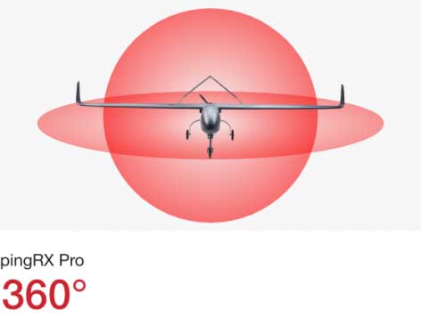
uAvionix has announced pingRX Pro, a detect-and-avoid ADS-B receiver for professional unmanned aircraft systems (UAS). PingRX Pro is expected to be available in the fourth quarter of this year.
pingRX Pro detects private and commercial aircraft operating on 978 MHz and 1090 MHz. The received aircraft’s identity, position and altitude are visualized on a moving map in real time, allowing the UAS operator or autopilot to remain well clear.
The new pingRX Pro continues uAvionix’s lineage of easy to integrate receivers with direct support for popular Ardupilot-based autopilot systems. By adding the protection of an aircraft-grade aluminum case and detachable remote mount antenna, pingRX Pro provides an ADS-B receiver for professional UAS operators who need performance, quality and flexibility for limitless UAS applications.
“UAvionix has led the way in ADS-B solutions for unmanned aircraft since our founding.” said Christian Ramsey, president of uAvionix. “Industry leaders and BVLOS operators continually choose ADS-B receivers as their primary detect-and-avoid solution. pingRX Pro now offers manufacturers and integrators the installation flexibility they need for their enterprise aircraft. ”
Weighing less than 8 grams, pingRX Pro features uAvionix ping ADS-B, proven in over a half-million ADS-B solutions worldwide, from UAS to airport vehicles to certified general aviation solutions.
PingRX Pro offers an external antenna, allowing operators to install it anywhere on the airframe. UAS are often designed from materials that can block radio frequencies and impair radio performance. By providing an external remote mounted antenna, performance can be maximized while providing critical protection of the receiver mounted inside the fuselage.
ADS-B Out
Diagram: uAvionix
ADS-B uses precision GPS information to broadcast the position of an aircraft in real time. The technology allows aircraft to share the skies more efficiently by telling each other where they are.
With ADS-B already widely adopted by manned aircraft, the task of detect and avoid is eased because the manned aircraft are broadcasting their position directly to the drone operator with no intermediary. While many aircraft not yet equipped with ADS-B OUT, nearly all large commercial operators are equipped.
The United States requires ADS-B OUT on all manned aircraft with an engine-driven electrical system operating near medium and large cities from the surface to 4,000 feet above ground.
Given the likelihood of ADS-B OUT on manned aircraft, and the density in these prime areas for inspection and package delivery, pingRX Pro ADS-B IN enables drone operators to meet their requirement to remain well clear of surrounding aircraft.
PingRX Pro tracks 100 simultaneous aircraft at ranges exceeding 150 miles, all at nearly 200% less power consumption of the alternatives.
In previous years, the Civil GPS Service Interface Committee (CGSIC) took place right before the start of the ION GNSS+ conference.
This year, the U.S. Department of Transportation (DOT) and the Coast Guard Navigation Center (NAVCEN) are holding the 60th meeting virtually, in collaboration with the Institute of Navigation (ION).
The meeting will take place Sept. 21-22 online before the annual ION GNSS+ conference, which will also take place virtually because of the COVID-19 pandemic.
All CGSIC meetings are free and open to the public. Anyone in the world with access to a computer can attend these public meetings of the U.S. Civil GPS Program.
DOT serves as the civil lead for the GPS program and chairs the CGSIC in this capacity. NAVCEN is assigned duties as deputy chair and executive secretariat for the CGSIC.
Subcommittees of the CGSIC for Timing, International Information, and Surveying-Mapping-Geosciences will hold meetings Sept. 21, and a summary of these meetings will be presented to the CGSIC plenary session on Sept. 22.
The keynote speaker for this year’s plenary session will be Major General John E. Shaw, Combined Force Space Component Commander, U.S. Space Command, and Commander, Space Operations Command, U.S. Space Force.
Presentations this year include:
PNT updates from various countries around the world
Atomic clocks for fundamental physics: time for discovery
Missouri Department of Agriculture land survey program
National PNT Policy Update from the National Space Council
Mobile geospatial technology’s role in tracking beetle infestation in our nation’s forests
The full agenda is available online. CGSIC presentations will be posted online shortly after the meeting ends. Register for the meetings here.
The Federal Aviation Administration (FAA) has awarded $3.3 million in research, education and training grants to universities that comprise the FAA’s Air Transportation Center of Excellence (COE) for Unmanned Aircraft Systems, also known as the Alliance for System Safety of UAS through Research Excellence (ASSURE).
“These grants will help develop a greater array of innovative strategies to more effectively deploy drones during emergency response situations,” said U.S. Transportation Secretary Elaine Chao.
The FAA’s CEO program, authorized by Congress, is a long-term, cost-sharing partnership between academia, industry and government. The program enables the FAA to work with center members and affiliates to conduct research in airspace and airport planning and design, environment and aviation safety, FAA said.
Mississippi State University received the Alliance for System Safety of UAS through ASSURE Program Management grant for $1,290,410. This grant is for the ASSURE lead university to provide overall program management. This program management will include tracking of financial information for all core university project activities; reviewing and vetting of all project related documentation prior to submission to the FAA; hosting and facilitating all FAA-required meetings; and outreach to government, industry and academia, FAA said.
Six universities, including the University of Alabama–Huntsville ($1,101,000), New Mexico State University ($234,000), the University of Alaska, Fairbanks ($245,000), Mississippi State University ($130,000), North Carolina State University ($124,979) and Oregon State University ($165,000) received grants for Disaster Preparedness and Response (Phase I and II, as directed by Congress). According to FAA, this research will provide insight into the safe integration of UAS into the disaster preparedness and response areas. This research will look at how UAS can aid in disaster preparedness and response to different natural and human-made disasters. It will focus on procedures to coordinate with the Department of Interior, the Department of Homeland Security, the Federal Emergency Management Agency and other federal, local and state organizations to ensure proper coordination during those emergencies.
There are currently 1.65 million recreational and commercial drones in the active UAS fleet. That number is expected to grow to as high as 2.31 million by 2024, FAA reported. The ASSURE grants are aimed at continuing the safe and successful integration of drones into the nation’s airspace.
“Collaboration is hugely important as we work to safely integrate UAS into the aerospace system,” said FAA Administrator Steve Dickson. “These important grants fund the research which allows us to learn and implement the safety measures associated with UAS operations in the airspace.”
The COE universities received a total of $3.3 million to advance specific goals and projects. This is the second round of ASSURE grants. The grants listed above will bring the fiscal year 2020 total for this COE to $5.8 million.
Hexagon AB has acquired Tacticaware, which provides lidar-based 3D surveillance software to monitor and protect critical infrastructure and buildings.
Tacticaware’s flagship solution, Accur8vision, is a volumetric detection security system offering 3D surveillance. Unlike conventional systems that typically only monitor perimeters, Accur8vision delivers situational awareness of an intruder’s exact location, size, speed and movement trajectory — all of which can be visualized within a 3D digital reality of the area under surveillance, Tacticaware said.
“Hexagon has long been a leader in sensor and 3D visualization technology,” said Hexagon President and CEO Ola Rollén. “Our award-winning 3D surveillance solution, Leica BLK247, fuses lidar, video and thermal imaging with edge computing and intelligent algorithms to instantly detect and report physical changes within an environment. Together with the BLK247 and HxGN OnCall, our comprehensive portfolio of next-generation public safety solutions, Hexagon can now offer those working to make our world a safer place a fully integrated end-to-end security surveillance solution for 24-hour, full visibility of critical infrastructure and spaces to call-taking, dispatch, incident planning and response and more.”