“Seen & Heard” is a monthly feature of GPS World magazine, traveling the world to capture interesting and unusual news stories involving the GNSS/PNT industry.
Free navigation history course
Photo: Harvard University
Harvard University offers PredictionX: Lost Without Longitude, a free online course that examines the evolution of navigation from ancient methods to modern technologies. The program explores the science and history of navigation, focusing on the challenges of determining longitude before GPS existed. It highlights key advancements, such as John Harrison’s marine chronometer and the Longitude Prize. Through multimedia content — including videos, infographics and Worldwide Telescope tours — the course is designed to demonstrate how centuries of advancement in navigation enabled humanity to achieve milestones such as landing on the moon.
Self-driving cars collect geospatial data
Photo: Finnish Geospatial Research Institute
In Finland, self-driving cars are being used to collect geospatial data to address urban challenges. The ARVO autonomous vehicle from the Finnish Geospatial Research Institute is equipped with high-precision sensors that map its environment in real-time, collecting information on road conditions, urban vegetation as carbon sinks and factors influencing flood risks. In partnership with Aalto University and funded by the European Regional Development Fund, this initiative seeks to explore various uses of this data, such as city planning, environmental monitoring and infrastructure management.
Stopping scammers
Photo: Carlos Alvarez / iStock Editorial / Getty Images Plus / Getty Image
Google has taken legal action against a network of scammers responsible for creating more than 10,000 fake business listings on Google Maps. The scammers fabricated profiles targeting urgent service industries and bolstered them with fake reviews to appear credible. Victims were misled into contacting these fake businesses, which then sold their personal information as “leads” to legitimate service providers without consent. Google has removed the fake listings and is suing individuals involved in the scheme, CBS News reported.
Mapping Uganda’s disappearing tropical glaciers
Photo: guenterguni / E+ / Getty Image
Project Pressure, in collaboration with UNESCO and the Uganda Wildlife Authority, conducted an expedition to the Rwenzori Mountains to map the region’s disappearing tropical glaciers. The team created the first 3D model of Mt. Stanley’s glaciers and installed monitoring equipment, revealing that Mt. Speke and Mt. Baker have lost their glaciers entirely, while the Stanley Plateau Glacier has shrunk by 29.5 percent since 2020 and is heavily fragmented. The project aims to continue monitoring the glacial retreat, develop mitigation strategies and engage the local community in ongoing research.
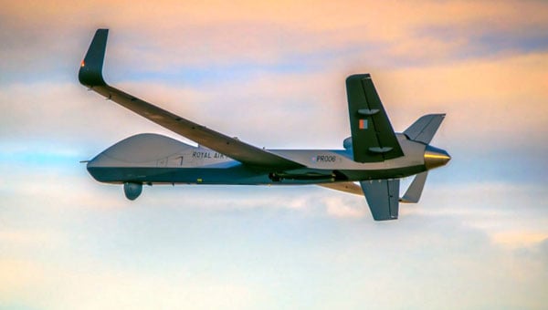
For anyone out there who has ever worked through a formal process of equipment development for subsequent FAA/military or other national certification, you would likely appreciate the significance of a UAV approval milestone.
General Atomics (GA-ASI) has just provided notice that the Royal Air Force (RAF) Protector RG Mk1 — based on the MQ-9A Reaper unmanned aircraft system (UAS) — has been granted a Military Type Certificate, having demonstrated compliance based on the requirements of STANAG 4671, NATO’s UAS airworthiness standard.
RAF Protector RG Mk-1 (Photo: GA-ASI)
This is big news for the RAF and GA-ASI, which enables this large Class III UAS to fly almost anywhere, without restricting flight over cities and other densely populated areas, and most importantly, facilitating flight within civil airspace. New capabilities that have been added include lightning and fire protection, as well as anti-icing systems. The strong airframe is designed to withstand long-term operational stress and exhibit a level of resilience against the effects of multiple airborne combat missions.
The software and electronic hardware were developed in accordance with current industry standards, which are intended to ensure the safety and reliability of systems. However, overall, GA-ASI has invested more than half a million dollars of its own money over 11 years to achieve this approval. Extensive environmental testing included lengthy, complex static and dynamic load tests, and extensive simulations were undertaken to verify performance over the operating envelope of the aircraft.
If you have ever seen a static ground test rig for stressing and even over-stressing an airframe, the significant number of hydraulic jacks within a massive steel girder enclosure is something to behold. Just building the structure and tuning the electronic systems which drive it, and fixing things on the rig and the airframe as tests progress over many months — this is a significant undertaking and investment.
The RAF has so far taken delivery of 11 of the 16 Protector UAS under order, and this certification is a major milestone on the way toward operational deployment. For General Atomics, this initiative hopes to not only lead to further military organizations purchasing an MTC-qualified UAS but also to open the door for civilian qualification options.
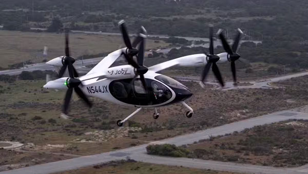
In the meantime, Joby Aviation in Santa Cruz, California, has just achieved a major milestone on the way to civil certification of its electric Vertical Take Off and Landing (eVTOL) passenger aircraft. With orders and sponsorship from Delta, Toyota, Uber and many others, the company is working toward piloted and autonomous flying taxis.
Joby’s eVTOL piloted transition from vertical to horizontal (Photo: Joby)
The major event involved an onboard pilot flying the eVTOL from a vertical takeoff through the transition to horizontal, wing-borne flight. This clears a major hurdle along the path to civil certification, enabling FAA pilots to be on board to monitor operations and fly the eVTOL.
The Joby test pilot first flew this production aircraft on April 22, with all the propellers horizontal and lifted off to about 30ft, just as a helicopter would take off. After a brief pause, the engine nacelles were rotated gradually forward and the eVTOL slowly crept forward. Traveling approximately 500 yards, the transition to wing-borne flight occurred as speed increased, and eventually, the climb-out began.
After several repetitions with two other test pilots, the piloted transition process was considered ready for operations and the next chapter was on the way to initial validation testing and air-taxi operations, which will be in Dubai.
Since 2017, Joby has flown a number of its eVTOL aircraft for a total of over 40,000 flight hours, with ground-pilot control, and with an onboard pilot in hover and forward flight. However, the transition phase has never been flown with an onboard pilot in full control. So that means presumably that all previous transitions had been controlled externally from the ground. This puts Joby well on the road to certification — other eVTOL manufacturers have made crewed transitions, but with separate propellers for lift and for forward flight – this is the first with one set of tilting propellers which is a principle operational feature of the Joby eVTOL.
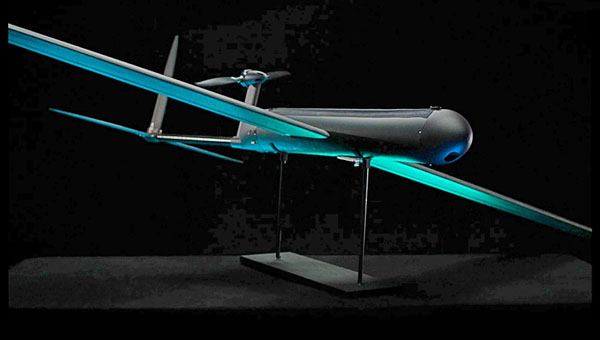
AeroVironment (AV) supplies a wide variety of UAS to the U.S. and other militaries. Nevertheless, the company has recently released information about a new one-way drone, which features enhanced capabilities, bringing forward “new, innovative solutions and improvements,” according to the release. This latest contender is apparently equipped to accept software upgrades throughout its design lifetime to continuously add more capabilities and specializations.
The Red Dragon UAV differs in that it is claimed to be fully autonomous (when circumstances require it) and can navigate in GPS-denied environments.
Red Dragon UAV illustration (Image: AV)
Given that modern battlefields are an electronic nightmare for GNSS navigation and control/data channels, AV has endowed Red Dragon with a hardened GPS baseline system, augmented by visual navigation, digital scene matching and automatic target recognition, and also using airspeed and laser rangefinder inputs. When necessary, the UAV can continue to track its target without requiring satellite control signals. There is a return link back to the operator, but when that link goes down, Red could proceed alone, or optionally crash-land if targeting doesn’t meet pre-programmed parameters.
Carrying a 5lb charge, Red is not designed to return to its owner, rather to deliver a penetrating destructive explosion. Even if doesn’t self-destruct, no-one wants this package back, its completely disposable. With a 250-mile range flying at 50 mph to 60 mph, the UAV can accelerate at up to 100 mph in the final phase of its attack.
Built simply for ready use in the field and to greatly reduce unit volume manufacturing cost, this new one-way munition may be the result of lessons learned during recent battles – possibly just what forces think they need through the use of already combat-proven attack drones such as the AV Puma and Switchblade. It is reported that Red Dragon may have already experienced actual combat.
To recap, General Atomics’ most recent Reaper variant is now ready to fly almost anywhere with its very own UK MTC certification, Joby’s tilt-rotor eVTOL has cleared the piloted transition hurdle and AeroVironment has released a new kind of loitering munition with autonomy and GPS-denied navigation capability — both military and civilian UAVs at the forefront of unmanned evolution.
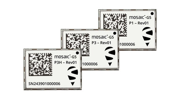
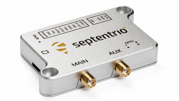
Septentrio, part of Hexagon, has introduced the mosaic-G5 series, expanding its line of compact GNSS receiver modules. The mosaic-G5 modules offer a 60% reduction in size and a 40% decrease in power consumption compared to the earlier mosaic-X5 receiver. The new modules measure 23 mm x 16 mm and weigh as little as 2.2 g, making them suitable for applications where size, weight and power are critical considerations, such as commercial UAVs, robotics and high-volume industrial equipment.
The mosaic-G5 modules offer reliable, high-accuracy positioning even in environments where GNSS signals may be degraded or obstructed. The mosaic-G5 product line includes several variants tailored to different use cases. The triple-band mosaic-G5 P1 is designed for high-volume applications, such as inspection drones and robotic mowers. The quad-band mosaic-G5 P3 and the triple-band heading module mosaic-G5 P3H offer enhanced positioning reliability in challenging conditions and are suited for applications such as delivery UAVs and light show UAVs. The P3H variant can calculate heading with a minimal baseline between two GNSS antennas, enabling accurate navigation for small autonomous device.
The new modules complement the mosaic product line, where the mosaic-X5 receiver remains as the benchmark for world-leading GNSS open signal anti-jamming and anti-spoofing resilience in a small form factor.
The mosaic-G5 modules complement Septentrio’s broader mosaic portfolio, which is recognized for its all-band GNSS technology, accuracy, reliability, and resilience to jamming and spoofing. The established mosaic-X5 receiver remains a benchmark for anti-jamming and anti-spoofing performance in a compact form factor. Like the mosaic-X5, the new modules are compatible with widely used open-source autopilots, such as PX4 and ArduPilot, simplifying integration and reducing development time. An evaluation kit, mosaic-go G5, is available to facilitate testing, and the RxTools user interface is provided for setup and evaluation.
Samples of the new mosaic-G5 P1, mosaic-G5 P3, and mosaic-G5 P3H modules are now available, with volume orders available for delivery later this year.
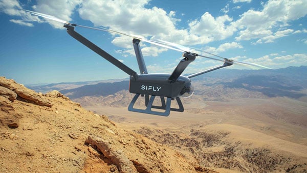
SiFly, a Silicon Valley-based startup, has introduced a new line of long-range electric drones designed to expand industrial capabilities. The company’s flagship Q12 platform delivers more than two hours of continuous hover and up to three hours in forward flight, enabling a 90-mile operational range while carrying payloads of up to 10 lbs. According to the company, this can lead to new possibilities for Beyond Visual Line-of-Sight (BVLOS) missions that were previously unattainable. SiFly plans to begin deliveries of the Q12 in the fourth quarter of 2025.
SiFly also unveiled the Q250, a heavy-lift drone capable of transporting 200-lbs payloads with a 100-minute endurance. This capability allows the Q250 to serve as a direct replacement for expensive helicopter operations in fire suppression, commercial and military cargo transport, and agricultural spraying.
SiFly is currently demonstrating its technology for public and private sector organizations across the United States and plans to announce multiple strategic industry partnerships in the coming months.
SPH Engineering has released an updated version of its UgCS UAV mission planning software, introducing significant improvements in elevation data accuracy and user control over flight parameters. The latest version allows users to explicitly set flight altitude for photogrammetry and corridor mapping missions, moving beyond the previous requirement to use ground sample distance as the primary input. This change seeks to offer UAV operators greater clarity and precision, particularly for operations that demand specific altitudes and a clear understanding of expected image resolution.
For users in the United States, UgCS now integrates USGS 1/3 Arc Second elevation data by default. This enhancement increases the resolution of elevation data from one data point every 30 m to one every 10 m, designed to improve the accuracy of terrain-following missions and making flight operations safer and more efficient in complex or mountainous areas.
The update also brings several interface enhancements designed to streamline the mission planning process. The ‘Export Route’ button is now more prominent, making it easier for users to access, especially those using the UgCS Open version. When creating a new route, the software displays the five most popular drone models first, simplifying selection for common platforms. For drones equipped with multi-lens cameras, UgCS now defaults to the wide camera during photogrammetry route planning, reducing the need for manual adjustments.
Additionally, the Visual Inspection route category has been improved with the introduction of a Circle tool, which simplifies the planning of circular orbits around specific points of interest. No-Fly Zones are now disabled by default in new installations, allowing for faster mission setup. The new version also expands hardware compatibility by adding support for the DJI M3D and M3TD UAVs.
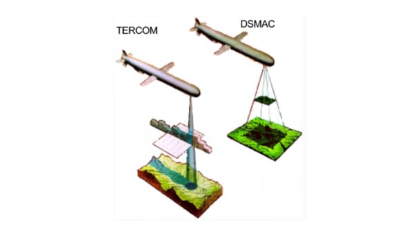
A report published in the April 7 edition of Satellite Navigation (DOI: 10.1186/s43020-025-00162-z) concludes that hybrid approaches are the most reliable solution for UAV navigation. The comprehensive review, by a research team from Prince Sultan University, evaluated 132 papers on UAV navigation in GPS-denied environments.
The research team focused on absolute and relative localization techniques including vision-based systems, lidar and terrain-aided algorithms. The review examined two primary methods for UAV navigation in GPS-denied areas:
absolute localization, which uses pre-mapped terrain data (such as TERCOM and DSMAC)
relative localization methods such as SLAM (simultaneous localization and mapping) and visual-inertial odometry that relies on real-time sensor data.
While absolute methods face limitations in featureless environments, relative techniques offer adaptability but require significant computational resources. Vision-based systems, particularly when enhanced with AI for feature recognition, hold considerable promise, though lighting conditions remain a challenge, the report concludes.
The research emphasizes the importance of sensor fusion, demonstrating that combining lidar, radar and inertial measurements – alongside advanced filtering techniques such as Kalman filters – can substantially improve navigation reliability.
Furthermore, real-time processing is crucial, with hardware accelerators like GPUs and optimized algorithms, such as LSTM networks, enabling faster data analysis and decision-making.
While hybrid systems combining terrain maps with live SLAM data offer a balance of accuracy and flexibility, the study acknowledges the need for further refinement to scale these solutions across various environments. Advancements in AI processing power and edge computing will be key to fully autonomous UAV operations in unpredictable real-world conditions.
“No single sensor or algorithm can solve all the challenges of GPS-denied navigation,” said Imen Jarraya, lead author of the study. “Our research shows that combining absolute and relative localization with multi-sensor fusion is the key to achieving reliable UAV navigation. Future work must focus on optimizing these systems to handle the unpredictability of environments ranging from dense urban areas to remote disaster zones.”
This research holds implications for industries relying on UAVs, such as logistics, agriculture, and defense, Jarraya explained. UAVs delivering medical supplies to remote or disaster-stricken areas could operate without GPS, and military drones could navigate in signal-jammed regions.
The study also points to the need for regulatory frameworks to standardize these technologies, ensuring their safe and efficient integration into future infrastructures. As UAVs become integral to smart cities and infrastructure inspection, overcoming the limitations of GPS will ensure safer, more effective operations. These findings encourage further investment in AI-driven navigation and collaborative research to refine these systems for global use.
AgEagle Aerial Systems has released its eBee VISION application software, introducing a suite of updates designed to enhance drone navigation in environments where GNSS signals are compromised or unavailable.
The latest software enables autonomous position updates with map referencing, allowing for precise navigation even when satellite signals are jammed, spoofed or blocked, according to the company. This seeks to provide operational continuity for defense personnel, public safety agencies and industrial teams operating in high-stakes, GNSS-denied environments such as dense urban centers, near critical infrastructure or in contested zones with active signal interference.
The update also introduces features such as optical flow stabilization for target lock, which uses visual cues to keep the camera centered on a point of interest during zoom-ins or drone movement. The software allows for adaptive behavior after GNSS recovery or visual repositioning, enabling seamless transitions if the drone’s position suddenly updates due to GNSS recovery or visual geo-referencing.
Additional enhancements include real-time mission duration and return-to-home estimates, optimized cruise speed in windy conditions, high-precision landings using lidar-based altitude calibration, a gimbal auto-recovery mechanism to clear obstructions mid-flight and smart motor speed reduction to prevent overheating during extreme conditions.
AgEagle, founded in 2010, designs and delivers flight hardware, sensors and software for users in energy, construction, agriculture and government sectors worldwide.
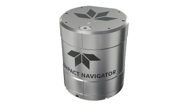
Teledyne Marine has launched the Teledyne Compact Navigator, an ultra-compact autonomous integrated navigation system engineered for subsea and surface vehicles. It is ideal for small vehicles, enabling inspection and survey operations on compact platforms. The system is offered in two depth-rated models, one capable of operating at 4,000 m and another at 300 m. The Compact Navigator consumes less than seven watts of power, extending mission duration by conserving energy. The system operates fully autonomously, eliminating the need for external aiding or operator intervention. Advanced phased array Doppler Velocity Log (DVL) technology enhances performance while allowing the device to be mounted on an autonomous underwater vehicle or ship hull.
Compact Navigator supports a broad range of applications, including ROVs, AUVs, shallow water surface navigation, operations in GNSS-denied environments and dynamic positioning for surface vehicles. The system provides true North-seeking gyrocompass-grade performance, and its web-based user interface supports integration, operation, and troubleshooting. It is factory-calibrated and offers a battery backup option for reliability in demanding conditions. The system operates independently of satellite signals, making it resistant to jamming or signal loss. This capability is significant for shallow water navigation, where GNSS-based systems may be unreliable.
GPS World is celebrating its 35th birthday in 2025 by welcoming back longtime editor Tracy Cozzens as Editor-at-Large.
A subsidiary of Cleveland-based North Coast Media, GPS World is a business-to-business media brand covering GPS, GNSS and Complementary positioning, navigation and timing solutions and trends.
“Serving this highly technical market for 20 years, I have been privileged to build wonderful relationships with many technology innovators,” Cozzens said. “I simply couldn’t stay away from what I know — GPS, GNSS and PNT — and whom I know. There’s nothing like our industry when it comes to non-stop technology breakthroughs that broadly advance our world.”
Cozzens returns to bring her deep industry insight and editorial leadership at a time when rapid innovation is reshaping GNSS/PNT landscapes.
“As a 35th birthday gift to our loyal family of GPS World marketing partners, and unmatched audience of readers — qualified/audited GPS/GNSS/PNT buyers and specifiers — we wooed Tracy Cozzens out of retirement,” said GPS World Sales Director Tod McCloskey. “Tracy’s award-winning gumshoe reporting and stellar content-creation skills for decades have helped keep industry leaders informed on GPS, GNSS and PNT technology trends. Now, Tracy also will help shape the content calendars for GPS World’s market-leading magazine, website, e-newsletters and social media.”
Cozzens will report directly to GPS World Editor Diane Sofranec.
FAA regulations require drone enthusiasts and commercial operators to equip their unmanned aircraft with approved remote identification (RID) capability. Following the FAA’s deadline on March 24, 2024, each registered drone in U.S. airspace is required to transmit its location, operator information, altitude, velocity and registration code. This data can be utilized to identify the drone’s operator. Additionally, most drones will need to include a timestamp for data synchronization and an emergency status indicator if necessary.
As a concession to purely recreational drone flyers, the FAA allows local organizations to designate and register an area as a reserved location for drone flying — an FAA-recognized Identification Area (FRIA) — and drones flown only in such locations are exempt from the RID regulation. As of September 2023, manufacturers are required to only sell drones with RID capability, and owners of older drones can purchase RID devices to add to their equipment. Some come with an internal GPS, but others connect to existing onboard GNSS receivers.
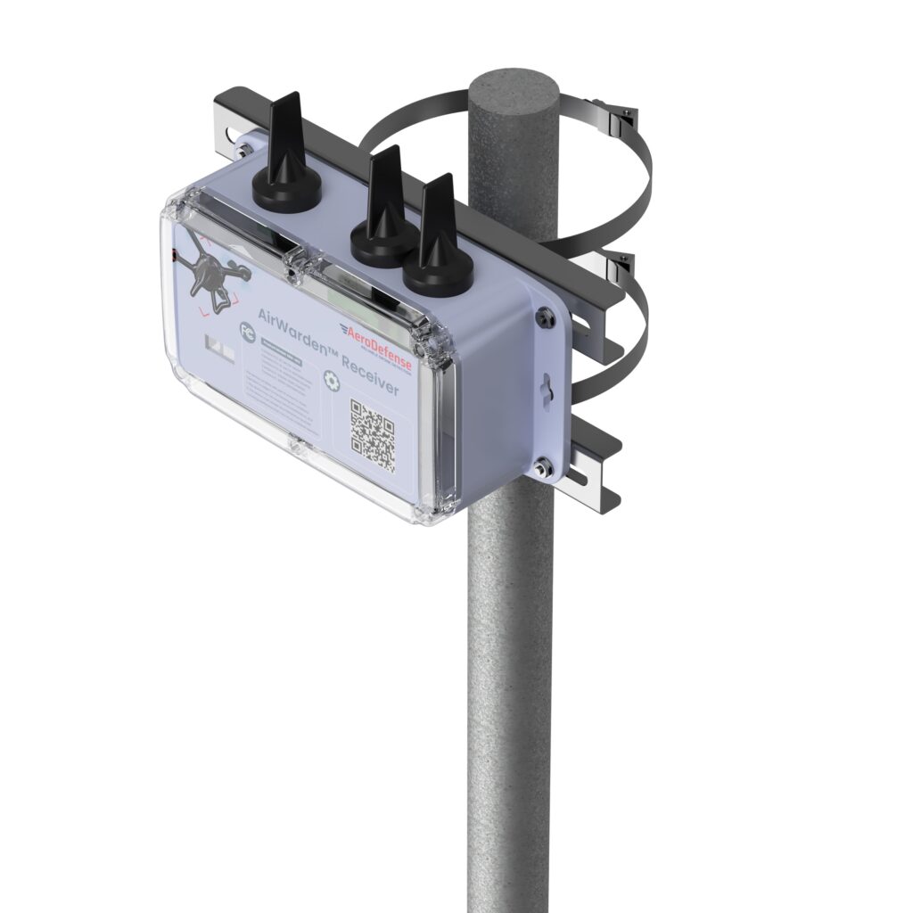
Given this RID-equipped population of drones, AeroDefense in Oceanport, New Jersey, has come up with an inexpensive way of locating legal drones and providing tracking information by providing an area monitoring system. Drone incursions into controlled airspace are not all malicious in nature— in fact, most have turned out to be accidental. So, a low-cost capability, such as the AirWarden Essential system, can be helpful to many facilities wishing to know what drones are in their airspace.
An AirWarden receiver mounted on a pole with a clear view of the sky above the monitored area can capture broadcast transmissions from drones flying overhead. the information is transmitted to a display system that highlights RID-equipped drones in the monitored area, showing not only the altitude and direction of the drones but also the operator’s identity and the location from which the drone was launched. The data can be downloaded to the internet, so facility personnel can also receive incursion warnings remotely, if they happen to be away from the facility. Otherwise, the system provides real-time alerts to your chosen display, along with a tracking history and the location of the launch point.
AeroDefense identifies several key locations for this system, including correctional facilities, venues such as stadiums and large outdoor gathering spots, airports, military bases, critical infrastructure such as power and water distribution centers, and industrial complexes.
What about non-RID drones, which can spy on technology, gather sensitive information, conduct reconnaissance of military facilities, smuggle contraband into correctional facilities, or even damage infrastructure? These drones can operate outside the law and evade FAA regulations. AirWarden indeed offers extensions that facilitate RF detection of both drone control and data transmissions, along with tracking the direction of drone movement. Combined with radar, the system becomes a robust detection solution for both RID and non-RID drones.
Mayman Aerospace in Long Beach, California, has developed a jet-powered vertical take-off and landing (VTOL) cargo drone. It needs only 10’ x 10’ to take off and land, and in flight, it is claimed to be able to reach 500mph (Mach 0.75) and operate at 20,000 ft.
Razor VTOL drone with vectoring jet-powered thrust. (Photo: Mayman)
The Razor VTOL features gimballed, jet-powered thrust for takeoff and landing and a high-speed sprint speed for fast deliveries on the battlefield. The initial application might be for the Department of Defense, but Mayman anticipates that other commercial applications already exist for rapid 50-lb cargo transit.
And Mayman describes other capabilities as including artificial GPS-denied navigation and autonomous control for reliability and accuracy in areas where signal jamming is present. The aircraft has an automatic abort/land capability in the event of catastrophic failure.
This new intelligent vehicle appears capable of various applications, including fast cargo transit, Intelligence, Surveillance, Target Acquisition and Reconnaissance (ISTAR), disaster recovery, serving as a low-cost maneuverable airborne target for pilot training and even functioning as an attack drone.
While recent sky-filled drone incursions have been highly reported and publicized, another means to help detect and locate their operators cannot come at a better time. The AirWarden system appears to have a lot of promise, notwithstanding that radar, RF and acoustic detection systems may also be required for “illegal” drones. Thrust-vectoring, cargo carrying and autonomy in a drone are not just a novel combination, these capabilities do appear to have a great deal of promise for both military and commercial operations.
More than 20 years ago, in these pages, we referred to television broadcast signals as “signals of opportunity” that might be used for positioning, navigation and timing (PNT). Since then, several other signals with a different primary purpose have also been considered as sources of PNT, and some have been used routinely for years now, such as WiFi routers for indoor navigation. On Feb. 26, 2025, the National Association of Broadcasters (NAB) filed a petition for rulemaking with the Federal Communications Commission (FCC) for television to transition to a new standard, ATSC 3.0, that enables what they call Broadcast Positioning System (BPS), as a way to enhance GPS resiliency. I asked NAB’s chief technology officer and executive vice president, Sam Matheny, to answer a few questions about the organization’s proposal. In next month’s issue, we will present a different perspective on it.
Question: Briefly, what is the history of the relevant standards?
Answer: The Advanced Television Systems Committee (ATSC) is an international standards development organization. ATSC developed ATSC 3.0 as the “next-gen” standard, and the International Telecommunications Union (ITU) adopted it as a recommended digital broadcast standard in 2020. Broadcasters in the United States began experimental ATSC 3.0 transmissions in 2016, and there are currently more than 100 transmitters broadcasting in 80 markets. Other nations currently using or considering ATSC 3.0 include Brazil, India, South Korea, Canada, Mexico, Jamaica and Trinidad and Tobago. NAB’s petition to the FCC requests permission to fully transition to ATSC 3.0 by 2030.
Q: Briefly, what is the history of the BPS project/proposal?
A: BPS is a datacast application that uses ATSC 3.0. We at NAB authored a seminal paper on BPS in 2021 and built our first prototype in 2022. We put our second prototype on the air in 2023. We signed a Cooperative Research and Development Agreement (CRADA) with the National Institute of Standards and Technology (NIST) in 2024 and published our first joint paper earlier this year. The paper concludes that “the stability of BPS time transfer is comparable to or better than GNSS, making BPS a viable complementary PNT solution when GNSS is unavailable.”
Our petition to the FCC highlights a transition to ATSC 3.0 that enables the nationwide deployment of BPS.
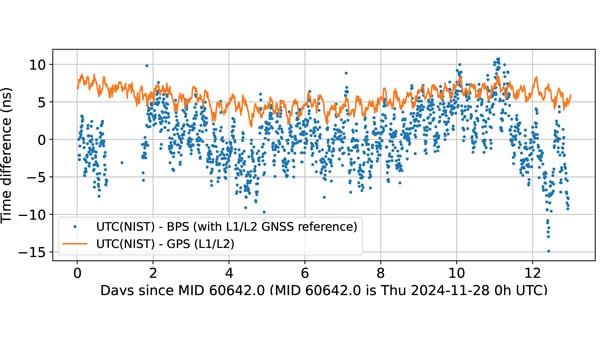
BPS time is comparable to dual band GPS (L1/L2) time. The data are recorded as 10-minute averages. (Graphic: National Association of Broadcasters)
Q: What is the motivation for broadcasters to implement BPS? What’s in it for them?
A: BPS will further secure television broadcasters’ role in the fabric of U.S. telecommunications. We also witnessed the innovation around GPS, with more than 7 billion GPS receivers being built into myriad devices. We’d like to see BPS experience similar innovation, which will bring new business opportunities. We believe that there is an opportunity for a public-private partnership with the government to deploy BPS for economic and national security.
Q: What have your tests so far shown regarding the timing accuracy of your signals? How much more R&D is required?
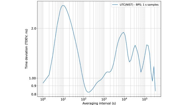
A: We’ve completed a wide variety of testing over the years, but probably of most interest is the work done with NIST. They ran common-view experiments using the BPS signal transmitted from KWGN, a TV station in Denver. Receivers were placed at two different facilities equipped with NIST timescale. Their Boulder facility is 30 km away with non-line-of-sight (NLOS) propagation, and their Fort Collins facility is 106 km away with line-of-sight propagation. A 21-day-long test showed that the time deviation (TDEV) statistics were better than 2 ns for all intervals. NIST also tested the stability of the NLOS signal alone at the Boulder facility and found that the TDEV statistics were better than 3 ns.
Q: How can BPS help improve GNSS resilience and integrity?
A: BPS functions completely independent of GNSS, so in the event of an acute GNSS disruption or catastrophic outage, BPS can be a resilient secondary source of timing for critical infrastructure (CI). Integrating BPS into CI applications also makes GPS a less attractive target for intentional disruption. Additionally, being independent means that BPS and GPS can work together in a hybrid mode, where, for example, BPS can help detect jamming and spoofing of GPS.
Time deviation (TDEV) statistics of BPS is less than 3 ns, even for the NLOS test scenario. (Graphic: National Association of Broadcasters))
Q: What are the main benefits of BPS?
A: The key benefits of BPS include:
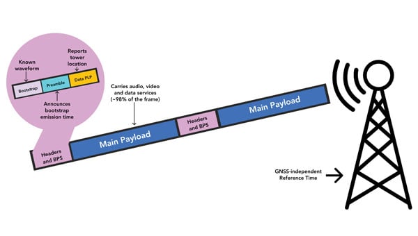
Existing infrastructure: BPS leverages existing television transmission infrastructure making it low cost and easy to deploy. There are more than 1,700 full power TV stations on the air today. These stations, considered critical infrastructure, are designed to stay on the air on a 24 x 7 x 365 basis, including during emergencies.
Nationwide coverage: Television transmissions are “high-power/high-tower” signals that provide nationwide coverage. Their broadcast power can be up to 1 MW and from towers up to 2,000 feet tall. The signals can be received NLOS, including indoors. The strength of these signals makes them difficult to jam or spoof.
Frequency diversity: Television in the United States operates on 210 MHz of licensed spectrum divided into 35 6-MHz channels. There are multiple stations/channels in each market, which offer geographic diversity along with frequency diversity.
Passive receivers: BPS is a broadcast service, just like GPS, and supports an unlimited number of simultaneous users with no bottlenecks or two-way connectivity dependencies.
Standards-based: BPS is based on ATSC 3.0, an ITU-recommended digital terrestrial broadcast standard with the support of a global community and supply chain.
Independent: BPS operates completely independent of GNSS and is a self-synchronizing network that does not rely on Internet or cellular connectivity.
BPS Installation at WHUT. TV transmission infrastructure is already built out. Only a BPS synchronizer and a reference timing source need to be added. (Graphic: National Association of Broadcasters))
Q: What are the main initial use cases? What are some additional ones that might come later?
A: The initial use case is providing resilient time to CI, which includes the power grid, cellular communications, and financial and data centers. A 2019 NIST study estimated the economic risk of losing GPS at $1 billion a day, and in 2024 a National Security Space Association study said the impact of a disruption or loss would be incalculable, so addressing this CI need is vital. Longer term, we see hybrid applications where BPS and GPS are used together. BPS can be leveraged for GPS health monitoring, which could be especially useful for transportation systems and can help identify and mitigate compromised GPS service. Going further, we see applications for positioning and navigation, plus other data services such as AGPS, GPS validation and RTK.
Q: How will the BPS service be monitored after full deployment?
A: NAB has developed a cloud-based network operations center (NOC) to monitor the health of the BPS-enabled TV stations. As part of our leader-follower construct, TV stations in the BPS mesh network measure each other’s emissions and send the data to the NOC, which can identify any issues.
Q: Which television manufacturers have expressed interest so far?
A: Hisense, LG, Panasonic, Samsung, Sony and TCL are already selling NEXTGEN TV sets. It is important to note that these televisions don’t use BPS. They ignore the BPS data and pay attention to the audio and video payload. The reverse is true for a BPS receiver; it ignores the audio and video and simply uses the BPS data. Both services rely on ATSC 3.0, but they use different parts of the signal.
BPS leader-follower mesh network example. WHUT is configured as a leader tower, and WNUV is set up as a follower tower deriving traceable time from WHUT’s signal. At full deployment, the remaining 12 towers in the DC-Baltimore area can also follow WHUT. (Graphic: National Association of Broadcasters))
Q: Have you talked to any GNSS receiver manufacturers yet?
A: Yes, we have healthy interest from numerous receiver manufacturers. They see BPS as a nice addition to their product lineups. Conversations have focused on performance and integration.
Q: Are there any technical, commercial or legal arguments against BPS? Do you anticipate resistance to your proposal from any quarters?
A: We have not heard any such arguments against BPS. To the contrary, people have been intrigued and supportive of the concept. Recognizing that BPS requires transition to ATSC 3.0, some groups have expressed concerns over the television set upgrade cost for low-income viewers. However, ATSC 3.0 receiver accessories retail for less than $100 today, and prices will drop further with scale.
Q: How does your proposal address backward compatibility?
A: NAB’s petition calls for all television stations to transition to ATSC 3.0 and for all television sets to be equipped to receive ATSC 3.0. As mentioned earlier, millions of NEXTGEN TV sets are already being purchased, so our petition aligns with natural product replacement cycles, including low-cost converters for older TVs.
Q: What is your arrangement and division of labor with NIST?
A: Our CRADA with NIST also includes Nexstar, one of our members. Nexstar operates KWGN where we deployed BPS. NAB provided NIST with BPS receivers and technical support. NIST scientists then performed independent measurements and analysis of BPS using their own techniques and processes. It has been a great experience for us to engage with and learn from the team at NIST. The effort has taught us a great deal about PNT and the capabilities of BPS.
Q: Now that you have submitted your proposal to the FCC, what do you expect to be the timeline for approval, implementation and adoption?
A: The FCC follows a notice-and-comment process for adopting changes to its rules, which can take anywhere from several months to more than a year. The FCC previously convened the Future of Television Initiative to investigate issues associated with the transition, which should give us a bit of a head start. In NAB’s petition, we ask the FCC to establish a timeline that would have the top 55 television markets fully transitioned to ATSC 3.0 by 2028 and the remaining markets by 2030.
Q: How can the GNSS/PNT community help this project?
A: First, it can support the transition to ATSC 3.0 because BPS relies upon it. We need a full transition to recognize its potential. Next, it can continue to collaborate with us. We introduced BPS at the DOT Roundtable in 2022. Since then, we’ve collaborated with the PNT community on research, scientific papers, product design and deployments. We’ve built BPS together, and now we need to deploy it together.
SBG Systems has released Qinertia 4.2, an updated version of its post-processing software for GNSS and inertial navigation system (INS) data. This release introduces several new features and improvements aimed at refining processing accuracy and usability, according to SBG Systems.
One of the notable additions is the beta version of Precise Point Positioning Fixed Ambiguity, which allows centimeter-level accuracy processing without the need for a base station. The update also includes a new RTS smoothing option, known as the Trajectory Smoother, which enhances INS processing by removing artifacts while maintaining precision. Another feature is the standalone Lever Arm Estimation Tool, now available as a separate application with a simplified interface. The Advanced Virtual Base Station Network Creation has been enhanced with improved base station quality indicators to increase reliability.
Other updates in Qinertia 4.2 include compatibility with the New Ellipse series and support for Teledyne Intrepid INS. The software now offers faster processing speeds, enhanced geodesy functionalities such as base station velocity analysis, and updated tools for assessing processing quality through new status plots. It also supports the latest firmware versions of Ekinox, Apogee, Navsight and Quanta systems.
These updates aim to improve workflow efficiency and data quality for professionals working with GNSS and INS systems.