Category: Uncategorized

  • NAL Research, SGM Technology and Tschudi to launch maritime navigation and tracking solutions

    NAL Research, SGM Technology and Tschudi to launch maritime navigation and tracking solutions

    NAL Research, SGM Technology AS and Tschudi Shipping Company have formed a strategic collaboration to develop a new line of navigation and tracking products designed for the commercial shipping industry, using Iridium’s low-Earth orbit (LEO) satellite network.

    This joint effort comes amid a rising need for reliable asset tracking and secure navigation tools in high-risk maritime regions, where threats to GNSS signals — such as jamming, spoofing and other forms of interference — are increasing on a global scale. Maritime authorities in some areas have reported a 350% increase in vessels affected by such disruptions in the past six months, according to NorthStandard. The technological interference has caused real-world consequences, including shipping collisions, operational delays, financial setbacks for global trade, and safety risks for crews at sea.

    “As a fifth-generation shipping company, we’ve witnessed the evolution of maritime navigation, but never before have we faced technological threats such as GPS jamming and spoofing,” said Felix Tschudi, chairman of Tschudi Group. “These disruptions pose a serious risk to vessel safety, crew welfare, and the reliability of global trade routes. The industry must act collectively to address these vulnerabilities to protect maritime personnel and assets.”

    The partnership’s initial focus is on integrating NAL Research’s decades-long expertise in assured positioning, navigation, and timing (APNT), tracking, and connectivity with the Iridium PNT service. This service provides a resilient, fully authenticated L-band signal engineered to withstand spoofing and jamming. The venture is also drawing upon SGM’s more than 15 years of experience in maritime technology and Tschudi Shipping Company’s international operations, bolstered by 140 years in commercial shipping and logistics. Together, their aim is to deliver high-reliability navigation solutions for environments where GNSS signals are compromised. Trials of the new solution are now underway.

    “Protection against GPS vulnerabilities is no longer a nice-to-have, but a necessity to ensure operational success and asset safety,” said NAL Research President Robert Bills. “Through this collaborative effort, we are aiming to achieve complete global situational awareness and increase safety at sea for our commercial maritime customers, even in the most remote and challenging situations.”

    “In today’s maritime landscape, the threat of GPS jamming and spoofing is no longer theoretical — it’s a growing reality. Ensuring navigational safety is critical, not just for protecting cargo and vessels, but for safeguarding the lives of seafarers who rely on precise and trustworthy systems every day,” said Steffen Grefsgård, CEO of SGM Technology AS.

  • GNSS RTK 4 Click board achieves sub-meter positioning accuracy

    GNSS RTK 4 Click board achieves sub-meter positioning accuracy

    GNSS RTK 4 Click is a compact add-on board from Mikroe that provides high-precision GNSS positioning with real-time kinematics (RTK). The board features the LG290P a quad-band GNSS module from Quectel capable of receiving signals from GPS, GLONASS, Galileo, BDS, QZSS and NavIC while using SBAS for enhanced accuracy.

    “This new Click board allows designers to simply and quickly develop systems with sub-metre positioning accuracy,” comments Nebojsa Matic, CEO of MIKROE. “Autonomous navigation, UAVs, intelligent robotics, surveying, and precision agriculture are just some of the applications that will benefit.”

    GNSS RTK 4 Click  supports multi-mode RTK algorithms with fast convergence times and high accuracy, interference detection, and integrity monitoring, ensuring sub-meter positioning in demanding environments. It features UART and L2C interfaces, a USB Type-C port for standalone configuration, and a backup battery option for continuous operation.

    GNSS RTK 4 Click  also features the ClickID function which enables automatic identification by the host system, simplifying use. It  is fully compatible with the mikroBUS socket and can be used on any host system supporting the mikroBUS standard. It comes with the mikroSDK open-source libraries, offering excellent flexibility for evaluation and customization.

  • Xsens Avior OEM IMU offers high accuracy and stability in demanding conditions

    Xsens Avior OEM IMU offers high accuracy and stability in demanding conditions

    Xsens has launched Xsens Avior, a lightweight, OEM form factor inertial measurement unit (IMU) with a compact 36.8mm x 40mm footprint that offers enhanced performance in a wide variety of industrial and commercial applications.

    The Xsens Avior is suitable for products manufactured in high volume thanks to its vertical 10×2-pin socket connector for simple board mounting, and its tolerance of any mounting orientation in all three axes. The product also eases design integration, with UART, CAN, SPI and I2C interfaces on-board and support for RS232 and RS422 via the product’s development kit or an external transceiver.

    Xsens has integrated a new generation of sensing components in the Avior, as well as advanced analog filtering for higher stability and noise reduction, resulting in substantially better performance compared to the previous generation product. Heading accuracy is 1° RMS and roll and pitch accuracy is 0.2° RMS. Stability is also enhanced in the Xsens Avior: in-run bias stability in the gyroscope is 8°/hr, and accelerometer in-run bias stability is 15μg.

    Weighing 35.2g, the Xsens Avior is enclosed in a robust aluminum housing and has a rating of IP51 and an operating temperature range of –40°C to 85°C. The sensor’s small size, light weight, high performance and robust construction provide value in applications such as drones, 3D mapping, and marine remotely operated vehicles (ROVs).

    Flexible product options

    The new sensor is available in three versions:

    • IMU providing calibrated inertial sensor data
    • Vertical Reference Unit (VRU) providing accurate, calibrated values for roll and pitch, and unreferenced yaw data
    • Attitude and Heading Reference System (AHRS), providing accurate, calibrated roll and pitch values, and heading data referenced to true North

    The Xsens Avior is available in a ready-to-use hardware development kit, and is supplied with free software development kits supporting the C#/C++, Python, ROS 1 and ROS 2 and Matlab environments, as well as full documentation and step-by-step guides to design integration.

    Key product specifications:

    • Typical power consumption: <0.5W
    • Maximum output data rate: 400Hz
    • Gyroscope full range: ±300°/s
    • Accelerometer full range: ±8 g
    • Magnetometer full range: ±8 G
    • Fully supported in the MT Software Suite development environment
    • Certifications: CE, FCC, RoHS, ITAR free
  • Quantum magnetometer could solve GNSS-denied navigation problems

    Quantum magnetometer could solve GNSS-denied navigation problems

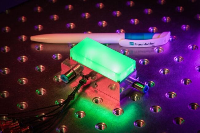
    Fraunhofer IAF presented the latest version of its compact integrated quantum magnetometer at World of Quantum in Munich. The diamond-based system is characterized by its robustness, high integration density, and measurement sensitivity. It offers new measurement possibilities for a wide range of applications, including navigation.

    The highly integrated vector magnetometer developed by the Fraunhofer Institute for Applied Solid State Physics IAF is based on nitrogen vacancies (NV) in diamond and provides access to the smallest magnetic fields with a previously unattainable degree of flexibility and precision. The miniaturized measuring system offers new possibilities in applications that require precise measurement with minimal interference, such as in biochemical measurements of nerve pathways or in microelectronics.

    “What makes the diamond-based NV vector magnetometer so special is its native and intuitive functionality, which enables it to precisely measure the vector components of the Earth’s magnetic field under most operating conditions,” explained Michael Stoebe, Business Unit Manager for Quantum Devices at Fraunhofer IAF. “This makes the sensor not only a technical innovation, but also a significant advance in sensor technology,”

    The unique properties of the NV center on the diamond lattice, which is arranged along the four crystal axes, enable all vector components of the magnetic field to be detected with a single sensor chip using <100> diamond. This reduces the calibration effort and opens up new possibilities for applications that were previously limited by the restrictions of conventional magnetometers. This sensor represents a significant step toward more precise and efficient measurement techniques, according to Fraunhofer.

    Safe navigation without GNSS

    Despite their high precision and coverage, today’s navigation systems are often prone to interference and are not available everywhere. Alternative navigation methods that function independently of GNSS are therefore gaining in importance. The Earth’s magnetic field is a promising basis for this, as it exhibits regional differences that can be used as an invisible map for autonomous navigation, especially in areas where GNSS signals are disrupted or difficult to receive.

    The quantum sensor developed at Fraunhofer IAF makes it possible to create comprehensive magnetic field maps and provide reliable navigation based on them. The vector magnetometer offers an autonomous, interference-free method for global positioning and navigation. It complements satellite-based navigation and also works without satellite signals, for example underwater, in canyons, underground, in buildings, or in tunnels.

    Increased integration density and sensitivity

    Researchers at Fraunhofer IAF have succeeded in reducing the size of their integrated quantum magnetometer by a factor of 30 in just one year. The sensor head now has a compact size comparable to conventional and industrially used optically pumped gas cell magnetometers (OPMs) with high sensitivity in the picotesla range. The diamond-based system stands out from competing technologies thanks to its high robustness and wide measuring range, which allows it to be used flexibly in a wide variety of measurement scenarios with extremely low calibration requirements.

    “We are striving for even greater integration density, while increasing sensitivity. Our goal for the coming year is to reduce the size of the sensor by a factor of 5 again, while further increasing sensitivity to enable measurements in the sub-picotesla range,” emphasizes Dr. Michael Stoebe.

    The special feature of the integrated quantum magnetometers developed by Fraunhofer IAF is their optional water cooling, which ensures robust and reliable measurement of magnetic fields even under the difficult operating conditions. This flexibility in design and integration is what sets the latest sensor prototypes from the Freiburg-based institute apart.

    “We take an application-oriented approach to the continuous development of our sensor systems and respond to the individual requirements placed on our systems,” said Michael Kunzer, project manager at Fraunhofer IAF.

    In addition to further developing the system, the core element of the sensor — its nitrogen-vacancy (NV)-doped diamond sensor head — is also being improved at Fraunhofer IAF. The synthetic diamond is grown at the institute in special reactors and further processed into quantum devices through the controlled exchange of carbon atoms with nitrogen atoms. The wafer sizes of the ultra-pure diamond are to be further developed next year from the current two inches to industrially scalable four-inch wafers.

    Geological measurements quickly and contact-free

    The quantum magnetometer developed by Fraunhofer IAF enables precise, contact-free localization of underground mineral deposits, thereby providing access to valuable resources. It can also detect unexploded ordnance over large areas, significantly reducing the risk to people in affected areas. Using the same principle as in navigation, the composition of the Earth’s crust and its magnetic field can be used to draw conclusions about geological formations. Magnetic anomalies such as ore deposits or metallic objects such as unexploded ordnance can thus be detected.

    The collected data can be converted into magnetic maps that show the locations of suspicious objects and provide information about their depth, shape, and size. This method enables comprehensive and non-invasive exploration of affected areas and the location of even deep-lying objects.

    World of Quantum 2025

    At the World of Quantum 2025 June 24-27 in Munich, Fraunhofer IAF presentsthe latest prototype of its NV vector magnetometer n Hall A1, Booth 439-3, on the Quantum Future Boulevard.

  • Launchpad: dual-band antennas, mobile clocks, UAV upgrades and more

    Launchpad: dual-band antennas, mobile clocks, UAV upgrades and more

    Read a roundup of recent products in the GNSS and inertial positioning industry from the June 2025 issue of GPS World magazine.


    MOBILE

    Photo: SiTime

    Mobile Clock Generators
    With an integrated MEMS resonator

    SiTime’s Symphonic is a mobile clock generator built around the SiT30100, which integrates a MEMS resonator and a temperature sensor in a compact 2.22 mm² chip. Designed for 5G and GNSS chipsets, Symphonic delivers precise, resilient clock signals while supporting efficient power consumption in mobile and IoT devices, including smartphones, tablets, laptops and asset trackers.

    The integrated temperature sensor feeds data to compensation algorithms, providing frequency stability as low as ±0.5 parts per million to enhance GPS accuracy and shorten lock times, which is critical for reliable performance in challenging environments. The device operates across a -30°C to 90°C temperature range and is engineered for dynamic stability and power optimization, helping to mitigate electromagnetic interference. Symphonic features four configurable clock outputs, each capable of delivering 76.8 MHz, 38.4 MHz or 19.2 MHz, suitable for baseband, radio frequency and GNSS applications. The single-chip design eliminates the need for external resonators.

    SiTime, sitime.com

    Photo: Calian GNSS

    Dual-Band L1/L5 Antenna
    For critical positioning and timing applications

    The TW3885TL is a dual-band GNSS antenna engineered to deliver reliable, interference-free signal reception for critical positioning and timing applications. Supporting both L1 and L5 frequency bands, the antenna is compatible with a wide range of global navigation satellite systems, including GPS, QZSS, Galileo, BeiDou, GLONASS and NavIC, as well as regional satellite-based augmentation systems.
    The TW3885TL incorporates advanced filtering technology designed to reduce interference from crowded radio frequency environments. It features a low-noise preamplifier, with a typical noise figure of less than 2.5 dB, and offers high gain, typically around 40 dB. The antenna maintains a low axial ratio, under 2.0 dB, and exhibits tight phase center variation, which contributes to precise timing and superior signal quality. Constructed with a weatherproof enclosure rated to IP69K, the TW3885TL is suitable for permanent outdoor installations and can be mounted through-hole, with optional accessories available to support various mounting configurations.

    Calian GNSS, calian.com


    UAV

    Photo: AgEagle Aerial Systems

    Software Upgrades
    Enable positioning in GNSS-denied environments

    eBee VISION application software now includes a suite of updates for UAV navigation in environments where GNSS signals are compromised or unavailable. The latest software enables autonomous position updates with map referencing, allowing for precise navigation even when satellite signals are jammed, spoofed or blocked. This product is suitable for defense personnel, public safety agencies, and industrial teams working in high-stakes environments where GNSS signals are unavailable (densely populated urban areas, near critical infrastructure, or in contested zones with active interference). The update introduces optical flow stabilization for target lock, which uses visual cues to keep the camera centered on a point of interest during zoom-ins or drone movement. The software allows for adaptive behavior after GNSS recovery or visual repositioning. Additional enhancements include real-time mission duration and return-to-home estimates, optimized cruise speed in windy conditions, high-precision landings using lidar-based altitude calibration, a gimbal auto-recovery mechanism to clear obstructions mid-flight, and smart motor speed reduction to prevent overheating during extreme conditions.

    AgEagle Aerial Systems, ageagle.com

    Photo: Inertial Labs

    IMU
    For unmanned commercial and defense applications

    The IMU-H100 is a micro-electromechanical systems inertial measurement unit (IMU) designed to improve tactical guidance and navigation for UAVs, short-range missiles, precision-guided munitions, and a range of commercial applications.
    The tactical-grade unit features accelerometers and gyroscopes on all three axes. It offers a gyro bias of 1° per hour and an accelerometer bias of 1 mg. The unit measures 5 in³ and weighs 160 g. The IMU-H100 surpasses comparable products in data rate, measurement range, stability and repeatability, even under challenging conditions such as vibration, shock, high acceleration, spinning, temperature changes and acoustic noise.

    Inertial Labs, a VIAVI Solutions company, inertiallabs.com

  • OneNav L5-direct navigates through GPS interference in field trial

    OneNav L5-direct navigates through GPS interference in field trial

    For the first time, the oneNav L5-direct receiver was flown on a UAV through a simulated electronic warfare GPS signal interference field. The assessment took place Feb. 12 at the Emerging Technology Lab at U.S. Special Operations Command (USSOCOM). This non-classified evaluation replicated battlefield conditions, including variable speeds, altitudes, maneuvers and robust L5 signal interference.

    Assessment Setup

    The assessment included two GNSS devices secured to the UAV, an onboard navigation computer and an onboard interference device. Two additional interference sources were located on the ground.

    A simplified block diagram of the assessment setup. (Credit: oneNav)
    A simplified block diagram of the assessment setup. (Credit: oneNav)

    The onboard navigation computer integrated data from both GNSS receivers to determine and maintain the vehicle’s position and guide its movement. GNSS 1 was a competitor L1/L5 dual-band receiver that uses the L1C/A signal for initial acquisition before adding L5 signals. GNSS 2 was the oneNav L5-direct receiver, which exclusively utilized modern L5-band signals for both acquisition and tracking.

    Test Conditions and Results

    The in-flight assessment, conducted on a UAV under real-world dynamic and RF interference conditions, demonstrated that the oneNav L5-direct receiver operates independently of legacy GNSS signals such as L1 and L2. While conventional dual-band receivers require L1 acquisition before transitioning to L5 tracking, the oneNav solution used only modern L5 signals for both functions6.

    The Emerging Technology Lab implemented comprehensive RF interference protocols, including both ground-based and airborne signal interference across multiple L5 frequencies. The oneNav L5-direct receiver maintained tracking capabilities during L5/E5a signal interference centered at 1176.45 MHz. This performance is attributed to the receiver’s wideband RF front-end architecture, which enables simultaneous processing across an extensive frequency range. The system leverages Galileo’s dual sideband configuration (E5a and E5b), automatically transitioning to E5b when E5a experiences interference—a feature unique to the oneNav technology. A brief six-second delay was observed during this transition, reflecting a three-second lock loss on E5a followed by a three-second acquisition of E5b. The ability to track E5b signals, despite a 10 dB power differential, highlights the receiver’s sensitivity.

    L5-direct FPGA attached to the assessment UAV. (Credit: oneNav)
    L5-direct FPGA attached to the assessment UAV. (Credit: oneNav)

    Key Findings

    • The oneNav L5-direct GNSS receiver acquired, tracked and provided location data to the drone flight computer under actual flight dynamics and through L5 band signal interference.
    • Direct acquisition and tracking using only L5-band signals was demonstrated, confirming immunity to L1 signal interference.
    • The receiver demonstrated resilience to L5 in-band signal interference at typical electronic warfare power levels, quickly adapting by switching to the E5b sideband when E5a was disrupted.
    • The receiver maintained stability and responsiveness when both E5a and E5b sidebands were blocked.
    • Continuous tracking functioned well with the BeiDou constellation off and the almanac on or off6.

    Technical Background

    The oneNav L5-direct technology was originally developed for consumer applications such as wearables, phones and surface vehicles. Its adaptability allows for rapid customization and deployment across a range of platforms, including those requiring robust performance in challenging environments.

    Because the L5-direct receiver uses signals exclusively within the L5 band, it can leverage the advanced features of these signals. L5-band signals offer greater power and increased resistance to RF interference compared to L1 signals. Industry experts, including Prof. Brad Parkinson, recognize the advantages of L5-only receivers for jam resistance.

    Currently implemented on FPGA architecture, a future L5-direct ASIC is expected to deliver performance improvements, including enhanced acquisition and tracking capabilities.

  • UAV companies discuss FAA BVLOS policy at White House

    UAV companies discuss FAA BVLOS policy at White House

    Representatives from 18 drone technology companies — including AgEagle Aerial Systems, uAvionix, BRINC, Kelly Hills and Pierce Aerospace — participated in a second high-level, invitation-only policy discussion with the White House, hosted by the Office of Information and Regulatory Affairs (OIRA). This most recent engagement was centered on the proposed FAA Rule Part 108, which will define the regulatory framework for beyond visual line of sight (BVLOS) drone operations across the United States.

    The finalization of FAA Rule Part 108 is expected to replace the current piecemeal waiver-based system, providing a more predictable, scalable, and innovation-friendly regulatory environment.

    Enactment of Part 108 would remove operational barriers, drive capital investment, and unlock next-generation drone technologies that enhance both commercial and public sector applications, explained AgEagle CEO Bill Irby.

    “This follow-up invitation by OIRA reaffirms the strategic importance of expanding BVLOS operations for the domestic drone industry,” Irby said. “Thoughtful and timely rulemaking can accelerate innovation, improve safety and compliance, and strengthen the U.S. position as a global leader in drone technology. Of particular value was the discussion of how streamlined regulation will allow broader deployment of autonomous data solutions and open the door for increased economic activity.”

    The engagement was made possible in part through the leadership and coordination of the Association for Uncrewed Vehicle Systems International (AUVSI) and the Commercial Drone Alliance (CDA), who played key roles in facilitating industry participation and ensuring productive dialogue between the private sector and federal stakeholders.

  • Low-cost antennas power high-precision space-based positioning

    Low-cost antennas power high-precision space-based positioning

    A novel method using signals of opportunity from low-Earth orbit (LEO) satellites is redefining what’s possible in satellite-based navigation. Researchers have developed a joint pseudo-range and Doppler positioning technique that taps into signals from constellations like Starlink and Iridium NEXT — without relying on traditional navigation signal structures.

    By employing low-cost, wide-beam antennas and a specially designed time–frequency inversion algorithm, the team achieved remarkable accuracy: 3.6 meters in 2D and 6.2 meters in 3D, surpassing Starlink positioning approaches based on parabolic antennas by 35%.

    Technical barriers in using signals of opportunity include signal transmission times, low signal power, and imprecise orbital data, all of which hinder accurate positioning. Addressing these challenges demands a new approach to extracting usable navigation data from LEO constellations.

    In response, researchers from the Aerospace Information Research Institute introduced a joint pseudo-range and Doppler positioning method using wide-beam antennas to receive LEO satellite SOPs. The approach centers on a signal time–frequency inversion algorithm that reconstructs key signal parameters, alongside a novel accuracy metric called Equivalent Position Dilution of Precision (EPDOP).

    Real-world experiments combining Starlink Doppler data and Iridium NEXT pseudo-range signals confirmed strong performance, especially in long-baseline conditions — reinforcing the method’s global applicability.

    To overcome the cost and complexity of existing satellite tracking equipment, the team employed low-noise bock (LNB) wide-beam antennas capable of simultaneously receiving signals from multiple Starlink satellites. The core innovation lies in a signal processing algorithm that estimates transmission time and frequency from the received code phase and Doppler shifts — enabling both pseudo-range and Doppler observations without needing exact satellite clock data or real-time ephemeris.

    To quantify system performance under real-world errors, the researchers developed the EPDOP metric, adapted to mixed measurement inputs. Tests demonstrated the method’s robustness: 3.6 m 2D and 6.2 m 3D positioning using Starlink Doppler signals, and up to 24 m (2D) and 41 m (3D) accuracy using Iridium NEXT SOPs over a 40 km baseline. Compared to Doppler positioning techniques, the algorithm reduced positioning errors by over one-third and successfully suppressed the impact of orbital inaccuracies inherent in public two-line element set (TLE) datasets.

    “This work marks a key step toward accessible, accurate navigation using commercial satellite constellations,” said lead author Ying Xu. “By integrating Doppler and pseudo-range measurements and introducing a flexible precision metric, we can now harness Starlink and Iridium NEXT signals for high-precision positioning, even without access to proprietary signal structures. The proposed low-cost architecture opens new possibilities for resilient navigation in GPS-denied environments.”

    Because of its ability to operate with low-cost antennas and weak, unstructured signals, the technique is poised to support a wide range of applications: from autonomous driving and unmanned aerial vehicle (UAV) navigation in remote regions to emergency response and IoT asset tracking. Its resilience to satellite orbital prediction errors and adaptability across different LEO constellations make it a strong contender for next-generation positioning systems. As LEO deployments continue to expand globally, this approach offers a scalable and practical solution for real-time, high-accuracy navigation—promising enhanced capabilities for both civilian infrastructure and defense operations.

    The researchers’ study is published in Satellite Navigation (DOI: 10.1186/s43020-025-00163-y).

    Signal acquisition of Iridium NEXT satellites’ signal in the long baseline positioning scenario. (Credit: Aerospace Information Research Institute)

  • PEAK System offers inertial measurement unit

    PEAK System offers inertial measurement unit

    PEAK System has introduced the PCAN-GPS Pro FD, a configurable sensor module for measuring the position, attitude and acceleration of objects. It has a robust aluminum housing suited for measurement in harsh environments.

    The device is equipped with a powerful microcontroller (M7/M4 dual-core), a magnetic field sensor, a three-axis gyroscope, a three-axis accelerometer, and the u-blox NEO-M9N satellite receiver for GPS, Galileo, BeiDou, GLONASS, SBAS and QZSS. It delivers satellite navigation measurement data with update rates of up to 25 Hz.

    The module transmits the sensor data via two parallel LEMO circular connectors via CAN 2.0 A/B (40 kbit/s to 1 Mbps) or CAN FD (40 kbit/s to 10 Mbps). The PCAN-GPS Pro FD is configured via USB-C using Windows software (included in delivery), after which the module operates as a standalone CAN node. The aluminum profile housing (IP50/IP54 with sealing connectors) ensures high protection and easy integration.

  • Inertial Labs unveils visual-aided inertial navigation system for GPS-denied environments

    Inertial Labs unveils visual-aided inertial navigation system for GPS-denied environments

    Inertial Labs, a VIAVI Solutions company, has introduced its Visual-Aided Inertial Navigation System (VINS), designed to help aircraft maintain accurate flight paths in environments where GPS/GNSS signals are unreliable.

    The launch follows a report from the U.S. Department of Transportation noting a rise in GPS jamming and spoofing incidents across North America and much of Western Europe. These disruptions, which now reach up to 700 cases worldwide each day, impact both commercial and military operations. War zones have seen the highest concentration of interference, with Lithuanian airspace alone recording more than 800 cases in the last three months of 2024. Communications and emergency services, which depend on precise timing and geolocation, are also affected.

    VINS is engineered for unmanned aerial vehicles to complete long-range missions in GNSS-challenged environments. The system leverages Maxar Raptor 3D vision-based positioning software, which estimates a vehicle’s absolute 3D position by comparing onboard camera imagery — day or infrared —with Maxar Precision3D satellite-derived maps using Perspective and Point principles.

    In GNSS-denied conditions, VINS can maintain a horizontal position within 35 m, a vertical position within 5 m, and velocity within 0.9 m per second of true values. It also holds heading accuracy within 1° and pitch/roll within 0.1°. With GNSS enabled, the system achieves a horizontal position of 1 meter, vertical position under 2 m, velocity accuracy of 0.03 m per second, heading within 0.1 °, and pitch/roll within 0.03°.

    The modular system is designed for low-altitude operation and includes processing and sensor modules, a GNSS or CRPA antenna, an air-data computer, and a digital windspeed sensor for use with both fixed-wing and multi-rotor UAVs. Optional features include a commercial off-the-shelf radio for data and absolute positioning in GPS-denied environments, as well as Iridium low-earth orbit (LEO) GNSS and M-Code/SAASM GNSS receivers.

    Inertial Labs and VIAVI will demonstrate VINS and the second-generation RSR Transcoder with GPS full constellation simulator at the 2025 Joint Navigation Conference (JNC), held June 2-5 in the Greater Cincinnati area. The products will be on display at the Inertial Labs (booth 430) and VIAVI (booth 406) stands.

    VIAVI and its Inertial Labs division will also present three sessions at the conference:

    • “3D Vision-Based Positioning for Autonomous Aerial Platform Navigation and Human-in-the-Loop Reconnaissance Mission,” presented with Maxar, Monday, June 2 at 1:50 p.m. ET.
    • “Anti-Jam/Spoof Phased Array Antenna,” Wednesday, June 4 at 10:50 a.m. ET.
    • “Retrofitting At-Risk GPS Defense Equipment with a Multi-Orbit LEO and GEO Clock System for Resilient PNT Services,” Wednesday, June 4 at 11:30 a.m. ET.
  • Thank you for registering

    Thank you for registering for the upcoming webinar, “Power-efficient GNSS: Optimizing location platforms for longevity and accuracy” sponsored by Quectel.

    A link to the live event will be sent to you two hours before the event. Your personalized event URL will be automatically generated by the ON24 system. To ensure receipt of the email, please whitelist this email address by adding it to your contacts: [email protected].

    This presentation will begin at 1 p.m. EDT on Thursday, June 26. A recording will also be sent to you the following day so you can watch it on-demand.

    Audience members may arrive 15 minutes prior to live time. If you have any questions, please contact event producer Halle Reid at [email protected].

  • Hi-Target and GMV sign strategic alliance on high-precision positioning solutions

    Hi-Target and GMV sign strategic alliance on high-precision positioning solutions

    Hi-Target, a Chinese high-precision positioning enterprise and manufacturer of high-end GNSS equipment, and GMV, a global technology group specializing in advanced navigation solutions, have established a strategic alliance to jointly develop integrated differential service solutions.

    Through this partnership, Hi-Target and GMV support a wide range of automation-driven positioning applications — ADAS, robotics, UAVs, precision agriculture, smart infrastructure and intelligent mobility systems.

    As industries progressively adopt automated technologies, precise and reliable positioning has become a foundational requirement across application domains. From today’s L2 and L2+ driver assistance systems (ADAS) in vehicles to autonomous UAV operations, robotic platforms, and the emerging needs of Level 3+ mobility solutions, the demand for scalable and high-accuracy positioning continues to grow.

    The strategic alliance between the two companies leverages Hi-Target’s strengths in high-precision satellite navigation and user-grade GNSS systems, along with GMV’s extensive global expertise in precise navigation algorithms and satellite-based augmentation services. The result will be a high-availability, low-latency positioning service with global reach.

    By combining their complementary technologies, including user-grade GNSS hardware, correction services, and augmentation infrastructure, Hi-Target and GMV will facilitate the adoption of high-precision positioning across various industries and geographic regions.

    Their collaboration will support system integrators, OEMs, and solution providers in accelerating the development and deployment of automation in sectors with increasing levels of autonomy.