Iridium Satellite Communications Inc. filed comments to the U.S. Federal Communications Commission (FCC) on Oct. 29 regarding outdated Ancillary Terrestrial Component (ATC) rules.
The company, operator of the Iridium satellite constellation — 66 low-Earth orbit satellites used for global voice and data communication from handheld satellite phones and other transceiver units — called for the rules to be removed by the FCC and replaced by new rules that better serve the spectrum ecosystem.
“Fifteen years ago, the FCC had a vision of satellite companies integrating terrestrial service into their core satellite business as a supplemental service. This vision has been never been successfully achieved — not once,” said Iridium spokesperson Jordan Hassin. “Instead, the result has been a constant whittling away at the rules to the point they have become irrelevant with a whole lot of collateral damage along the way. Given this history, it is appropriate for the FCC to consider the elimination of these outdated ATC rules while taking into account the realities of existing services and users.”
“ATC is an outdated concept that never developed as intended,” Rob McDowell, former commissioner of the FCC added.
The rules have resulted in proposals to get around them, such as Ligado, and significant fights over harmful spectrum interference to incumbent satellite systems. Ligado has sought to waive three gating criteria established by the FCC.
The Federal Aviation Administration’s (FAA) nationwide deployment of the Low Altitude Authorization and Notification Capability (LAANC) has exceeded all of the program’s original objectives.
Since the program began with a prototype system in November 2017, LAANC has processed more than 50,000 applications from drone operators for authorization to fly in controlled airspace. The system now covers almost 300 air traffic facilities serving approximately 500 airports, providing near-instantaneous approvals and allowing operators to quickly plan their flights. View a list of the participating facilities.
LAANC helps support the safe integration of drones into the nation’s airspace. The system uses airspace data provided through temporary flight restrictions, Notices to Airmen (NOTAMs) and unmanned aircraft system (UAS) facility maps that show the maximum altitude ceiling around airports where the FAA may authorize operations under Part 107, the small drone rule for commercial and public agency operators.
LAANC Service Suppliers
The FAA has approved 14 LAANC service suppliers. Instructions on how to apply are provided by each supplier:
Drone operators also can file for airspace authorizations using the FAA DroneZone, including for areas not covered by LAANC or when the operator holds a Part 107 waiver.
Telit has introduced a new positioning module aimed at India. The SL869T3-I combines GPS with India’s NavIC (IRNSS) navigation system and the country’s satellite-based augmentation system (SBAS), known as GAGAN.
The SL869T3-I module enables the creation of high-performance position reporting and navigation solutions. It complies with Automotive Industry Standard 140 (AIS-140) — an Indian government mandate that requires the use of NavIC for vehicle location tracking devices in all public transportation vehicles, effective April 2019.
The SL869T3-I is a 16 x 12.2-millimeter module with an LLC package. It is provided with a single RF input for L1 and L5 bands. It also contains Flash memory, a low noise amplifier (LNA) and SAW filters. The RF front end is specifically designed to comply with sensitivity specifications contained in AIS-140 standard.
“The new SL869T3-I is among the first IoT GNSS positioning receiver modules to deliver IRNSS/NavIC L5 coverage compliant with the Indian government’s AIS-140 regulation,” said Manish Watwani, EVP global product management, Telit. “This new addition to the Telit family of products results from more than 20 years’ experience in GNSS applications.”
For more information, visit booth C3.227 at Electronica, Nov. 13-16 in Munich, Germany.
Drone surveying software Virtual Surveyor now eliminates the need for clients to use third-party applications to prepare data for processing. Released this week, Virtual Surveyor 6.1 now handles on-the-fly projections that previously required a separate software package to set the data in the proper coordinate system.
“We have developed a completely new project experience for users of UAV data,” said Tom Op ‘t Eyndt, managing director of Virtual Surveyor in Belgium. “Version 6.1 will save our customers time and money once spent converting their drone data for processing in Virtual Surveyor.”
Virtual Surveyor bridges the gap between UAV photogrammetric processing applications and engineering computer-aided design (CAD) packages. The software generates an interactive onscreen environment with UAV orthophotos and digital surface models where the surveyor selects survey points and breaklines to define the topography, creating highly accurate topographic products for CAD input up to five times faster than otherwise possible.
“Our value proposition has always been to enable surveyors to derive topographic information from drone data and deliver the light-weight meaningful CAD model that engineers need,” said Op ‘t Eyndt.
Prior to Version 6.1, users always had to start from an orthophoto and digital surface model (DSM). Now, surveyors can drag and drop all kinds of files into Virtual Surveyor: points, raster, vectors and point clouds. The point clouds are converted to a DSM for manipulation and processing, dramatically accelerating the time required to generate the CAD model.
“Not only is this faster, but it eliminates the expense of purchasing additional software,” said Op ‘t Eyndt.
Some customers asked to work only with a CAD file, he explained. Although they work with drone data most of the time, they occasionally had to create a surface or contours from a traditional survey. They asked if this could be done in Virtual Surveyor as it would save them from paying for a subscription to a CAD software.
Long-time Virtual Surveyor clients will find the entire project experience has been streamlined and improved with new capabilities in V6.1:
Start from any data set. Projects can now be initiated from Orthophotos, DSMs, Point Cloud or CAD files.
Convert coordinates on the fly. Users can input data in any coordinate system and convert it during processing to another system after the project has begun.
Developers of Virtual Surveyor have also added these features to V6.1:
Automatic creation of section lines. V6.1 automatically generates sections from road surfaces to survey transportation routes in minutes.
Transparent layers. Users can add topographic or cadastral data to their project and view it through the orthophoto layer to annotate or draw boundaries.
“Overall, users will experience a faster processing environment in Virtual Surveyor 6.1 especially during complex tasks, such as making terrain modifications or calculating volumes,” said Op ‘t Eyndt. “Our goal with this version has been to make professional land surveyors more efficient.”
Current subscribers to Virtual Surveyor will see their software being updated automatically.
NextNav’s Metropolitan Beacon System (MBS) service has been accepted for use by NASA. NASA will use NextNav’s MBS network as part of its CERTAIN (City Environment for Range Testing of Autonomous Integrated Navigation) facilities at NASA’s Langley Research Center in Hampton, Virginia.
CERTAIN supports, among other programs, Urban Air Mobility (UAM), an air transportation system with myriad applications from small package delivery drones to passenger-carrying air taxis.
The Federal Aviation Administration (FAA) believes that by 2022 there will be more than 700,000 drones delivering packages, monitoring traffic and aiding in search and rescue operations. NASA’s role is to provide research findings to reduce technical barriers associated with integrating unmanned aircraft systems into the national airspace system.
NextNav’s MBS system facilitates urban drone operations where satellite-based GPS signals may not be available. The need to reliably know a drone’s location horizontally and vertically is critical to ensure safe operations in urban air traffic corridors.
Uber in the Mix. Uber and Bell (formerly Bell Helicopter) plan to launch an on-demand mobility venture, or flying taxis, nationwide by 2023, so the need to precisely track vehicles moving throughout city airspace is imminent.
The move to such flying taxis would require a change to current FAA-controlled airspace separation requirements, according to Tom Prevot, Uber’s director of airspace systems. He stated that the Uber venture foresees takeoffs and landings from city vertiports every 24 seconds, requiring a considerable reduction in the minimum-distance standards of 1,000 feet vertically or 3 to 5 nm horizontally, as currently mandated in FAA order JO 7110.65.
Metro Beacons. “NextNav’s MBS system provides us with new tools for the development of navigation systems in environments where GPS has traditionally been challenged,” said Evan Dill, Safety-Critical Avionics Systems Branch of NASA. “We’re looking forward to working with MBS as we develop new approaches to the operation of unmanned systems in urban environments.”
NextNav’s wide-area terrestrial positioning network provides accurate and secure location services, critical for unmanned aircraft navigation. In addition, MBS complements and integrates seamlessly with GPS and provides a level of geo-redundancy ensuring a safe and efficient system for future air transportation in cities and urban areas, with particularly difficult challenges at low altitudes where solutions such as radar, GPS and ADS-B are unreliable or insufficient.
Delivered over a managed network on nationwide licensed spectrum with carrier-grade dependability and metropolitan-wide coverage, NextNav said its services are designed for public safety applications, E911, critical infrastructure, as well consumer, Internet of Things (IoT) and commercial applications that require reliable 3D geolocation indoors and urban areas or precise timing.
Future city airspace filled with drones and passenger aircraft. (Image: NASA)
“We are proud to work with NASA and integrate MBS into its urban drone operations,” said Ganesh Pattabiraman, co-founder and CEO of NextNav. “The MBS system is designed for secure, reliable and consistent 3D geolocation capabilities, which are important for autonomous systems such as drones. NASA’s acquisition of the MBS system is an exciting milestone for MBS technology and a great partnership with NASA to address the key challenges in urban drone navigation and make it possible to explore new opportunities in unmanned operations.”
Update: The Camp Fire is now the deadliest fire in California history, claiming more than 50 lives.
DigitalGlobe’s WorldView-3 satellite collected new imagery of the deadly Camp Fire near Paradise, California.
The Camp Fire, which broke out Nov. 8, destroyed 90 percent of the town of Paradise. At least 29 people have died, making it the deadliest wildfire in the state’s history in more than 85 years, while more than 200 people are unaccounted for. Firefighters are still trying to contain the roaring blaze.
Here is a link to download a set of satellite images as well as a map graphic (PDF file). The satellite images include a couple of different views of the fire including:
A natural color overview of the area. The smoke from the wildfire obscures much of the area around Paradise and the surrounding communities.
Shortwave Infrared (SWIR) images of the area. SWIR images from our satellite can penetrate smoke caused by the fire and help clearly identify the fire lines and areas that have burned/are burning.
A rotated SWIR view of the fires, in case the orientation would be more useful for your graphic teams.
A reference image/map graphic (see PDF file) that should help you correlate the images to the locations on the ground.
Association recognizes key role the agency has played in furthering GPS.
The GPS Innovation Alliance (GPSIA), an organization dedicated to furthering GPS innovation, creativity and entrepreneurship, commends NASA — the U.S. National Aeronautics and Space Administration — on its momentous 60th anniversary. GPSIA celebrates the occasion by recognizing the vital role NASA has played in furthering and facilitating the growth of GPS around the world.
NASA has long been an integral supporter of GPS technologies, from its origins in the first space shuttle program, to the launch of the International Space Station (ISS), to the recent announcement of plans to develop an artificial intelligence-based GPS for space.
Throughout its history, NASA has played a critical role in the success of expanding GPS systems. NASA manages the Navigator GPS receiver, developed by its Goddard Space Flight Center, which has pushed GPS satellites out of lower earth orbit and beyond to enable high altitude applications and track weaker and more rural GPS signals with increased accuracy.
The Global Differential GPS System (GDGPS), a network of more than 350 GPS monitoring stations from 200 contributing organizations in 80 countries developed and operated by NASA’s Jet Propulsion Laboratory, provides an unparalleled combination of real time positioning accuracy and availability and acts as the largest network providing global, multiply-redundant, real time coverage of all GPS satellites at all times.
“GPS contributes immeasurable value to our economy and is used in almost every industry sector,” said NASA Administrator Jim Bridenstine. “It is crucial for our way of life on Earth — the way we communicate, navigate, conduct banking transactions, and so much more rely on our GPS systems. As NASA looks to its future endeavors in exploration and discovery, GPS will remain a cornerstone of technology to accomplish its missions. NASA looks forward to its continued work with the GPS Alliance.”
With the establishment of the National Executive Committee for Space-Based Positioning, Navigation, and Timing in 2004 and other governing bodies since, NASA has also acted as a thought leader on policy trends in the field, advising on and advocating for protections of GPS , one of the world’s most important and ubiquitous public resources.
“The alliance, on behalf of its members and the GNSS industry, congratulates NASA on six decades of cutting-edge innovation and wishes the agency continued success for many decades to come,” said J. David Grossman, executive director of the GPS Innovation Alliance. “As one of the most recognizable technologies in the world, GPS supports navigation, public safety, financial transactions and utilities and varied industries worldwide. We applaud NASA for its unwavering commitment to scientific innovation and to GPS around the globe, now and in the future.”
The GPS Innovation Alliance recognizes the ever increasing importance of GPS and other GNSS technologies to the global economy and infrastructure and is firmly committed to furthering GPS innovation, creativity and entrepreneurship. The GPS Innovation Alliance seeks to protect, promote and enhance the use of GPS.
Riegl now offers several new sensors and systems for airborne data gathering at various elevations.
At Intergeo 2018, the company unveiled sensors designed for low-flight altitudes, such as with UAVs. Riegl also introduced sensors designed for medium-flight altitudes used in large UAS/UAV/RPAS with higher payload capacity or in manned helicopters, and scanners and systems for data acquisition at high flight altitudes using manned fixed-wing aircraft.
The Riegl VQ-480II and VQ-580 II on display at Intergeo 2018. (Photo: Riegl)
Medium altitude. The Riegl VQ-480 II (Mark 2) and VQ-580 II (Mark 2) are designed for airborne applications at mid-altitudes for use on both manned and unmanned aircraft. Based on the capabilities of their predecessors VQ-480 and VQ-580, their new, sophisticated designs lead the quality of the systems to a new standard of performance and user-friendliness.
Both offer a measurement rate of up to 1,250,000 measurement/second and a wide field of view of 75 degrees, suitable for corridor mapping, city modeling and applications in agriculture and forestry.
With approximately 10 kg of weight, they are ready for integration into helicopters as well as unmanned UAVs with a higher payload capacity, and are compatible with stabilized platforms and even small hatches.
The VQ-480 II and VQ-580 II are prepared for smooth GNSS/IMU integration, offer interfaces for up to five optional cameras, and are equipped with a removable storage card and an integrated SSD for data storage.
While the VQ-480 II works at a laser wavelength of 1550 nm, the VQ-580 II works at 1064 nm wavelength suited to measure on ice and snow.
Laser scanning. Riegl’s VUX series, focusing on unmanned laser scanning, has also been expanded. With the Riegl VUX-240, a new airborne lidar sensor with less than 4 kg weight and a sophisticated design offering 75-degree field of view is now ready to be integrated on both small manned and larger unmanned aircraft.
The high measurement rate of 1,500,000 measurements/second and a high scan speed of up to 400 lines per second are the basis for high scan efficiency, especially in applications like power lines, railway tracks, pipeline inspection or topography in open-cast mining. Interfaces for an optional GNSS/INS system integration and up to four optional cameras are further convincing key features of the new scanner.
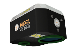
The Riegl VQ-840-G. (Photo: Riegl)
Bathymetry. For the bathymetric segment, the Riegl VQ-840-G has entered the marketplace. Designed for combined topographic and hydrographic surveys for use with large UAVs from lower flight altitudes, the scanner carries out laser range measurements for high-resolution surveying of underwater topography utilizing a green laser beam.
The scanner’s compact, lightweight and robust housing also can include an optional digital camera and an additional, fully integrated infrared laser rangefinder, and is compliant with typical hatches in aircrafts and with stabilized platforms.
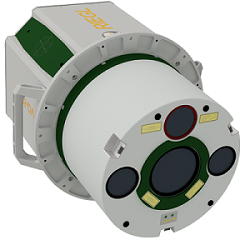
The Riegl VQ-880-GII. (Photo: Riegl)
Airborne laser scanning. The Riegl VQ-880-GII is a further improvement of the VQ-880-G topo-hydrographic airborne laser scanning system, offering online waveform processing and full waveform recording.
The improved setup includes a green laser channel, an integrated infrared laser channel, and an integrated dual camera system for RGB and IR. Typical applications include coastline and shallow water mapping, acquiring base data for flood prevention, and measurements for aggradation zones.
Also available are the VQ-780i airborne laser scanner and the VQ-1560i dual wavelength airborne mapping system.
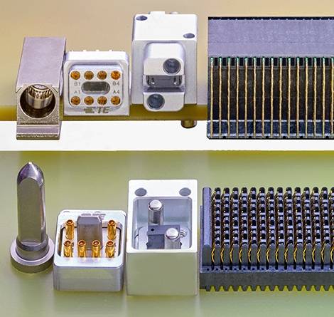
TE Connectivity’s high-frequency nanominiature contact doubles density, reduces packaging.
TE Connectivity, a connectivity and sensors company, has released new NanoRF modules and contacts, which double the density of VITA 67 RF modules for ANSI-standard VPX embedded computing applications.
Nano RF module and contacts, (Photos: TE Connectivity)
The high-frequency nanominiature coax contact is engineered with smaller contacts and a higher RF contact density within a multi-position module. This design enables smaller packaging and saves valuable space, TE said.
Half-size modules can support up to 12 RF contacts, and full-size modules can support 18 contacts or higher, with the option to customize contact count and position.
TE’s NanoRF modules and contacts are versatile, TE said. Their blind-mateable, float-mounted backplane contacts support module-to-module or box-to-box architecture. While they are designed for 0.047-inch coax cable, multiple cable types are available to fit the application’s needs. To bring high-frequency capability into a high-density modular package, the contacts are optimized for signal integrity and support frequencies up to 70 GHz.
The NanoRF’s design features a floating insert on the backplane side, with guide features to pre-align the array of contacts before they engage. This results in reliable mating and consistent RF performance up to 500 mating cycles.
“NanoRF offers outstanding high frequency coax contact density in a rugged modular package, which is ideal for providing reliable RF performance in harsh environments,” said Mike Walmsley, global product manager for TE’s Aerospace, Defense and Marine division. “It has been tested to VITA 72’s high vibration standards and is ready for VPX open architecture under VITA 67.3 — with a roadmap for expansion into other high- density packages.”
For more information on TE’s NanoRF modules and contacts, visit the product page or contact the Product Information Center at 1-800-522-6752.
A link to the live event will be sent to you two hours before the event. Your personalized event URL will be automatically generated by the ON24 system. To ensure receipt of the email, please whitelist this email address by adding it to your contacts: [email protected].
This presentation will begin on at 1 p.m. EST / 10 a.m. PST on Thursday, Nov. 15.
Audience members may arrive 15 minutes prior to live time. If you have any questions, please contact event producer Allison Barwacz at [email protected].
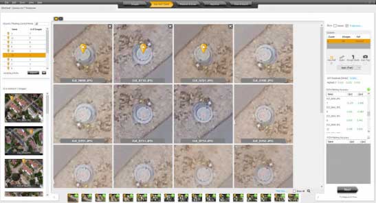
Datumate’s DatuSurvey 5.5 software offers 2D vectorized measurements and 3D point clouds models. (Screenshot: Datumate)
Datumate, a photogrammetry solution and 3D mapping software developer, has released its updated DatuSurvey 5.5 software, which offers 2D vectorized measurements and 3D point cloud models.
According to the company, with the updated software, users can now process thousands of images locally in an accelerated mode while maintaining survey-grade accuracy and professional engineering results. Organizations can also deploy Datumate’s solutions on single or multiple computers and take advantage of the accelerated and user-friendly processing of the project field data.
In addition, DatuSurvey 5.5 can process large amounts of drone imaging data locally and quickly. The software can also achieve survey-grade accuracy and geo-reference the model quickly and easily, the company added. Finally, it can plan and execute consecutive drone missions on unmapped and frequently changing areas.
According to Datumate, its team improved the geo-referencing workflow of the software when using ground control points. Users can now quickly and easily mark ground control points using zoomed-in image projections.
The company also added the ability to import coordinates to DatuFly Professional in addition to on-site or on-map mission planning. This will enable an efficient and accurate drone mission execution on specific and designated areas without depending on satellite and map source views, Datumate said.
Uplift adds commercially trained pilots and expands PrecisionHawk’s industry expertise and relationships in drone-based services for construction and facility management nationwide.
Uplift specializes in the delivery of turnkey inspection services for construction, building information management and real estate, and has provided drone services for national and global brands.
Its nationwide network of commercially trained drone pilots will join PrecisionHawk’s Droners.io network of more than 15,000 drone pilots. Suzanne El-Moursi, CEO of Uplift, will join PrecisionHawk’s executive leadership team managing the company’s construction line of business.
This is the fifth acquisition for PrecisionHawk in 2018. Early acquisitions include Droners.io and Airvid. In September, it purchased both Hazon Solutions and InspecTools which specialize in the delivery of inspection services and technology for the energy industry. Their integration with PrecisionHawk has created dynamic synergy, providing solutions that elevate airborne intelligence and strengthen the data value chain for the enterprise.
Similar to the energy space, the construction industry has experienced a rapid uptake in the adoption of commercial drone technology. Drones are now one of the leading innovative technologies that are transforming the construction process since they decrease the need for lengthy visual inspections, reduce planning time, improve worker safety and identify problems.
Uplift Data Partners was formed in 2015 as a fully integrated subsidiary of Clayco, one of the nation’s largest architecture, engineering, design-build and construction firms, with more than $2 billion in annual revenue.
Through the acquisition, Clayco will exclusively source its construction projects to PrecisionHawk, and will serve on PrecisionHawk’s Board of Advisors to support the growth of the company’s services and software in the construction industry.
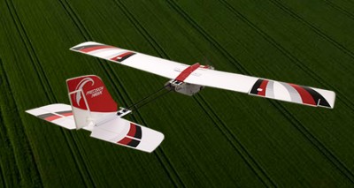
The PrecisionHawk UAV. (Photo: PrecisionHawk)
“PrecisionHawk is leading the commercial drone market by combining superior technology with deep expertise in the markets that they serve,” said Bob Clark, Clayco CEO. “Through this acquisition, Clayco customers gain access to a new level of technological sophistication for more scalable and robust operations, while continuing to benefit from Uplift’s deep understanding of the demanding nature of engineering and construction industry drone missions,.”
“This acquisition displays PrecisionHawk’s commitment to strengthening our technology and expertise in high-growth markets,” said Michael Chasen, PrecisionHawk CEO. “By combining PrecisionHawk’s leading-edge products and services with Uplift’s industry experience and training standards, our customers will receive best-in-class aerial data and analytics for complex construction and facility inspection projects through a simple and easy to procure process.”
“Our mission at Uplift is to support the modernization of the architecture, engineering and construction (AEC) industry by creating tools and training that improve the accessibility of drone services, thereby delivering true value to construction projects,” said Uplift CEO Suzanne El-Moursi. “The construction industry is uniquely rugged, yet defined by innovation and intelligence, and we are thrilled to join PrecisionHawk, a company that is both aligned to this mission and committed to the growth and expansion of the industry.”