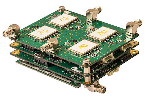
A European Union-funded initiative has developed a low-cost positioning and navigation system for unmanned aerial systems (UAS).
Photo: European GNSS Agency
Using multiple antennas, the device is based on off-the-shelf components and advanced data-fusion algorithms. It fuses GNSS and inertial data to enable accurate and reliable navigation.
The EU-funded Horizon 2020 GLAD-2 project developed the system. The work involved in-depth analysis of algorithms, hardware and software redesign, exhaustive refinement and repeated in-field testing.
Researchers used low-cost GNSS receivers, together with advanced data fusion with an inertial measurement unit, and barometer data to enhance the attitude and position of UAS in harsh GNSS environments. The system also avoided the use of magnetometers, making it immune to magnetic fields, and removing the need for system calibration when the magnetic environment is modified.
Photo: European GNSS Agency
Engineers selected different GNSS antennas and measured their performance according to technical and economic criteria. A multi-antenna approach enabled UAS to take accurate headings without suffering the usual problems inherent to magnetometers.
“The inertial sensors provide an excellent dynamic response at very high data rates, while GNSS serves as an absolute reference to prevent drift. In addition, differential GNSS carrier phase measurements can be used to obtain great accuracy in orientation by using the multi-antenna configuration,” said project coordinator Esther López of Spanish technology company ACORDE.
GLAD-2 achieved the commercialization of the low-cost navigation system, culminating in the European Conformity (CE) certification mark following the corresponding certification process. The CE mark indicates conformity with health, safety and environmental protection standards for products sold within the European Economic area.
The result is a highly competitive product aimed at the low-cost sector of the navigation systems market. “Due to its flexibility, the system fulfils the needs of a wide range of users, not only in UAS, but also in terrestrial and maritime environments applications,” López said.
Digital technology has provided society with hundreds of advances that make life easier and better for everyone. From the personal computer to the internet to the smartphone to the Internet of Things, we are increasingly living in a technologically driven world.
But what if those technologies were bound together and used to build a smart city?
What would it take to make such a complex network feasible? And what would it look like to live in a such a city?
Are these just the fevered imaginings of science fiction writers or could it be a real possibility? Let’s dig a little deeper.
Image: jamesteohart/Shutterstock.com
What is a smart city?
First, let’s put aside our Jetsons-inspired ideas of smart cities and look at what they really are.
A smart city contains a framework of Information and Communication Technologies (ICT), specifically designed to answer the overwhelming growth of urban centers.
The ICT framework contains an intelligent network of machines and objects that transmit data wirelessly. These cloud-based applications receive, evaluate and manage data, in real time, to help cities, corporations, and citizens make better decisions that improve quality of life.
Citizens can engage with smart city systems using smartphones and other mobile devices, including cars and homes.
Think the Internet of Things except on a much, much bigger scale. A citywide scale.
Being able to connect to a city’s physical infrastructure and services has the potential to cut costs and improve the city’s sustainability. Cities can improve energy dispersal, streamline city services, decrease traffic and reduce air pollution.
The development of smart cities starts with a digital foundation that allows better functionality, that’s more responsive to citizens, and ultimately creates a better urban environment.
Smart city technology
Cities are quickly on the move to embrace smart city technology. Autonomous vehicles are already providing data that could create environments where traffic lights become obsolete. Cities can reduce the number of cars as different transportation modes work together and communicate in real time.
Wi-Fi hotspots on a larger scale can transform the way users access information. And, as increased use of public transportation reduces the number of cars on the road, parking needs will decrease and enable cities to repurpose land for housing.
Energy sources could be better integrated into cities, helping to make a cleaner environment for everyone. At the same time, embedded sensors to detect gunshots or explosions will alert emergency services workers much faster. These systems will also find water, electric and gas issues and assign workers to make repairs as soon as they are needed.
All of this possible technological growth is predicated on the idea that technologies can help make people’s lives better in urban areas.
The six keys to a smart city
There are six key technologies that make a smart city efficient:
Smart energy. Residential and commercial buildings in smart cities use less energy, and the energy used is analyzed and data collected. Smart grids collect data and redirect energy to where it is most needed.
Smart transportation. Traffic monitoring is already happening in many large cities. But, by making parking smarter, people spend less time looking for parking spots. Smart traffic lights have cameras that monitor traffic so that it’s reflected in the traffic signals.
Smart data. The enormous amounts of data collected in a smart city must be analyzed in real time to be useful. Open data portals are one option for smart cities.
Smart infrastructure. Because smart cities can analyze huge amounts of data, leaders will be able to plan better. This allows proactive maintenance and better planning for future demand.
Smart mobility. The technology and the data that travel through it must be able to seamlessly move in and out of different municipal and private systems. Without this mobility, a smart city won’t work.
Smart internet of things (IoT) devices. Sensors are an essential part of a smart city. The information collected from sensors can be used to dispatch repairmen for immediate maintenance or emergency services for a car accident.
These technologies work in tandem to make a smart city smarter. As the world’s population continues to grow, and people relocate to urban areas, the need for smarter cities will help make the best use of all resources.
The powerful features of smart cities
Emerging trends like automation, machine learning and the internet of things (IoT) are keys leading to smart city adoption. It’s possible that any area of city management can be developed in a smart city.
Smart parking meters, for example, use an app to help drivers find empty spaces without circling crowded city blocks. The smart meter has a digital payment feature to prevent the need for coins.
Smart traffic management can monitor and analyze traffic flows to maximize streetlight usage and stop roadways from being too congested during rush-hour traffic. Smart public transit in smart cities ensures that public transportation meets user demand. Smart transit companies can coordinate services in real time to improve efficiency.
Energy efficiency and conservation are also features of smart cities. The smart sensors in the ground dim smart streetlights when there is no auto or pedestrian traffic. Smart grid technology can improve operations, maintenance and planning, supply power as needed, and monitor power outages.
Sanitation can also improve with smart technology, with either internet-connected trash cans and IoT-enabled fleet management for collection, or sensors that measure water parameters and guarantee the quality of drinking water.
Creating sustainable smart cities
Sustainability is another perk of smart cities. The population in urban centers is expected to increase in the coming years. Recent studies show that 80 percent of the U.S. population lives in urban areas, while that number was just 60 percent fifty years ago. Smart technology can help cities sustain growth and create efficient systems for citizens.
In Chicago, a smart cities innovation accelerator known as UI Labs has started developing tech to monitor storm drainage systems to stave off flooding from the Chicago River. A nine-month pilot program using the new tech was just completed and the researchers are compiling the data.
Another project being developed in Chicago creates digital maps of underground utility systems. Previously, the city had to rely on outdated and unfinished maps, slowing construction permitting and emergency services. Videos taken during underground construction are being turned into a digital map of the city underground.
In Spain, Barcelona has achieved a great deal in developing smart city tech and is reaping the benefits. The city has reduced congestion, lowered emissions, saved money on water and power, and improved economic development. Barcelona’s commitment to creating smarter urban infrastructure will change the quality of life for all who work, live, and visit the city.
The improvements have already saved the city a significant amount of money and lowered the consumption of water and energy. Barcelona estimates savings of $58 million on water, $50 million in increased parking revenues, and the creation of 47,000 new jobs. The city has also saved an additional $37 million each year in reduced lighting costs.
The Barcelona Lighting Masterplan, published in 2012, uses smart technologies to enhance efficiency and use of city lampposts. Two years later, more than 1,100 lampposts had been transformed to LED, which reduces energy waste. The lampposts can sense when pedestrians are nearby; the lights automatically dim to further conserve energy when the streets are empty.
To maximize the efficiency of city parks, Barcelona has implemented technologies that remotely sense and control park irrigation. The sensors also monitor rain and humidity, so maintenance workers can decide how much irrigation is necessary in each area. A system of electronic valves is remotely activated to deliver needed water around the city. The program has helped the city achieve a 25 percent increase in water conservation, saving nearly $555,000 per year.
As urban centers grow, the population places creates more environmental pressures. Smart City applications could help cut emissions by up to 15 percent.
In many cities of the developing world, the most water is lost from leakage in pipes. Deploying sensors and using the data can cut such losses by up to 25 percent. Overall, cities could potentially save 25 to 80 liters of water per person per day.
Air-quality sensors can identify the sources of pollution and galvanize governments and corporations into action. Beijing closely tracked the sources of air pollution and the city reduced deadly airborne pollutants by roughly 20 percent in less than a year.
While the data suggest that there are certainly obtainable benefits to smart city technologies, it is prohibitively expensive to build the infrastructure needed to implement the technologies. This has lead to Smart Cities Challenges in many countries.
Smart City Challenges
Smart city challenges are about achieving outcomes that all communities can find measurable improvements in, and ways to tackle previously unsolvable problems. New partnerships and networks can be formed to engage with residents and forge new relationships that encourage smart city innovation.
The Smart Cities Challenge in Canada is a competition open to empower communities around the globe to address local issues through new partnerships, using a smart cities approach. Finalists will receive support to develop their proposals. Winning proposals will receive prize money to help implement their new technologies.
In the United States, the Smart City Challenge was launched in 2015 by the U.S. Department of Transportation (DOT).
The winning proposal by Columbus, Ohio, is receiving prize money to help implement new technologies. According to the DOT, Columbus put forward an impressive, holistic vision for how technology can help all residents move better and access opportunity.
As challenge winners and their partner innovators improve a cityscape with smart technology, the benefits will be reaped by all who call the community home. Benefits can and will include lowered crime rates, increased job availability, independence for seniors and the disabled, a healthier environment, empowered citizens, and more opportunities for people to become active and have access to improved health care.
Conclusion
It seems that smart cities are fast approaching. As society’s technologies become intertwined and upgraded, the options for deploying new systems is unlimited.
And while there are certainly drawbacks in creating and maintaining a smart city, it is clear that humankind is looking forward to the next step in societal evolution.
This article originally appeared on IQ Directory and is reprinted with permission.
Anna Kucirkova
Anna Kucirkova speaks three languages has a passion for kids and writing. While she has been to many places in Europe and Southeast Asia, she still wants to explore the rest of the world.
Tallysman, a manufacturer of high-performance GNSS antennas and related components, has introduced a high-accuracy choke ring antenna: the Tallysman VeraChoke.
Adapting existing innovations on its patented VeraPhase antenna, Tallysman’s VeraChoke offers a choice in form factor for reference and monitoring applications.
The VC6100, the first model variant of the VeraChoke antenna, shares a common high-efficiency element design with itsVeraPhase counterpart. With the choke-style form-factor, however, the rings have been optimized for all GNSS signals and are slightly pyramidal in shape to improve reception of low-elevation satellites.
The VC6100 choke ring antenna offers a tight phase center variation of no more than ±1 mm for every frequency. It is capable of receiving all GNSS signals and achieves a very low axial ratio, the company said.
According to Tallysman, the VC6100 is competitively priced to help increase antenna density for reference deployments, CORS networks and monitoring applications. The antenna also supports large and small SCIGN radomes.
Tallysman’s GNSS antennas are on display at Booth Number 12.0D.059 at Intergeo, taking place Oct. 16-18 in Frankfurt, Germany.
Hexagon’s Geospatial division released a new version of M.App Enterprise for 2018, M.App Enterprise 16.5. This privately hosted solution allows organizations to deploy Hexagon Smart M.Apps that dynamically address their location-based business problems, the company said.
M.App Enterprise is the ideal platform to monitor assets, evaluate changes and take action, with the new release now including a native mobile client. The mobile workflow enables managers to assign tasks to field workers when it’s necessary to act. With the new mobile application, the platform is available from anywhere, including areas without internet access.
The new M.App Enterprise Studio comes with the Spatial Workshop user interface to manage spatial recipes. Its geoprocessing capabilities make it possible to make calculations with any type of geospatial data.
Updates to the Feature Analyzer component, such as thematic cluster markers, tooltips for boundary data and the option to share your views according to user type, make it easier to interactively derive insights from a variety of data, the company said.
The new product localization feature ensures that users are no longer lost in translation. New languages can be added to any local M.App Enterprise instance within minutes.
“M.App Enterprise provides a unified geospatial enterprise platform enabling customers and partners to create vertical solutions for their markets and industry segments,” said Georg Hammerer, chief technology officer of Hexagon’s Geospatial Division. “M.App Enterprise perfectly fits into the movement to the cloud and the trend towards self-service BI.”
Spectra Precision has launched a new brand identity and name for its survey and geographic information systems (GIS) suite of solutions. The organization will now be known as Spectra Geospatial.
The announcement was made at Intergeo 2018, the conference on geodesy, geoinformatics and land management, taking place Oct. 16-18 in Frankfurt, Germany.
The new Spectra Geospatial brand builds upon the reputation and equity built under the previous Spectra Precision identity and now reflects the organization’s evolution of providing a broad range of solutions specifically focused on the geospatial industry, the company said.
“We’ve built a strong reputation for quality and innovation over the past 25 years,” said Olivier Casabianca, general manager of Spectra Geospatial. “We are very proud to bring a new name and brand to the market that accurately reflects our customer and dedication to the industry.”
Spectra Geospatial delivers products to the survey, GIS and construction markets, with the brand offering a complete product portfolio including GNSS, GIS, optical total stations, data collection hardware, and field and office software.
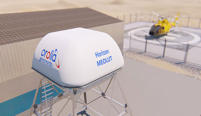
Orolia has introduced the McMurdo Horizon system, an S- and L- band compatible phased array system featuring antennas developed by Ball Aerospace with horizon-to-horizon coverage to capture search-and-rescue signals relayed from orbiting satellites immediately after line-of-sight is established.
The McMurdo Horizon system is now available to enhance regional search and rescue services worldwide with technology to complement existing and emerging ground-based systems at Medium-altitude Earth Orbit Search and Rescue (MEOSAR)ground stations.
Orolia’s McMurdo Horizon Medium Earth Orbit Local User Terminal (MEOLUT) can deliver enhanced search and rescue coverage and second-generation signal processing capabilities, in a compact form factor with no moving parts. The key technology innovation, based on a modified off-the-shelf phased array antenna developed by Ball Aerospace, is a custom-designed Orolia solution.
By pointing to satellites near the horizon, the McMurdo Horizon MEOLUT can detect and locate emergency beacons much farther away. This enhanced detection ability, combined with the McMurdo Selective Schedule Algorithm, enables the system to monitor more diverse regions, including the translation of oblong and irregular data points that are invisible to traditional systems.
Unicore Communications has launched CLAP-B, a multi-GNSS/MEMS integrated inertial navigation board, which integrates a miniaturized high-performance inertial measurement unit (IMU) on a compact high performance GNSS board.
The high-accuracy GNSS positioning coupled with a high-precision gyro and accelerometer provides stable, continuous three-dimensional position, velocity and attitude, as well as original acceleration and angular velocity measurements, even in GNSS-denied environments, the company said.
CLAP (Concurrent Localization & Attitude Pilot) technology is a high-precision multi-sensor fusion positioning and orientation technology developed by Unicore.
The CLAP- B, along with all the UM and UB family of receivers, are on display at BDStar booth C12.0C.022 for the duration of Intergeo 2018 starting Oct. 16 in Frankfurt, Germany.
Key features of the CLAP-B include:
Compact size: 46 × 71 × 17.1 mm
5-ns RMS PPS output
0.1 degree (1σ) pitch and roll
WINS optimized technology (wheel INS) for vehicles, wheeled robotics
With the features of compact size, light weight, low power consumption, and easy for integration and mass production, CLAP-B is suitable for applications such as autonomous driving, smart surveying, unmanned aerial vehicles and various attitude stabilization platforms. Customer samples will be available by the first quarter of 2019.
Hexagon AB will showcase its portfolio of reality capture hardware and integrated software at Intergeo 2018, hall 12.1, booth D.023.
According to the company, it will also offer hands-on demonstrations for reality capture devices, airborne sensors and UAVs, measurement technology, cloud computing, artificial intelligence applications and more.
“Intergeo is a premiere event for showcasing Hexagon’s vision of enabling smart digital realities that ultimately create autonomous connected ecosystems for digital transformation,” said Ola Rollén, president and CEO of Hexagon. “The increasing role of autonomous technology is vital to enabling unaided decisions that draw and act on information from multiple sources simultaneously and become smarter over time. This is our focus and we are once again honored to share our ACE ideas and progress around smart cities, BIM, Geospatial 4.0 and other highly relevant topics to be discussed at the event.”
A number of Hexagon executives also will be speaking during the show, including Mladen Stojic, president of Hexagon’s Geospatial Division, who will be discuss the potential of 5D location intelligence; Maximilian Weber, senior vice president of Hexagon’s Safety and Infrastructure Division, who will discuss the potential of “the Internet of People” within a smart city; Juergen Mayer, laser scanning business director for Hexagon’s Geosystems Division, who will present the latest development in edge computing technology; Michael Dorman, global director at Multivista (part of Hexagon), who will look at how today’s construction leaders are reducing design, construction, marketing and operating expenses throughout a project’s lifecycle with digital solutions; Valentin Fuchs, UAV product manager, and Anne Pitkaenen, UAV marketing manager for Hexagon’s Geosystems Division, who will provide insights into the latest developments of the Leica Aibot.
NCTech, a developer of reality imaging systems, will showcase its iSTAR Pulsar mobile 360-degree data capture system at Intergeo in Frankfurt, Germany.
Companies at Intergeo, including GeoSLAM and Orbit Geospatial Technologies, will also unveil innovative developments that incorporate iSTAR Pulsar.
iSTAR Pulsar is NCTech’s professional edge-to-cloud big data system, optimized for capture on the move. iSTAR Pulsar is designed to capture 360-degree data while mounted on a vehicle, drone or on foot.
At Intergeo, NCTech will be showing a demonstration of a future feature in its cloud-based processing software VR.WORLD that uses artificial intelligence and image recognition to analyse the images captured by iSTAR Pulsar. This means that objects like cars, trucks, traffic lights, road signs, pedestrians and cyclists can be automatically identified in images, the company said.
Photo: NCTech
Handheld 3D mobile mapping company GeoSLAM also will introduce new developments at Intergeo, including an innovation that integrates with iSTAR Pulsar.
“We immediately saw the potential for collaboration when NCTech introduced the iSTAR Pulsar,” said Mark Reid, head of strategic business development, GeoSLAM. “And now we’re excited to show the attendees at Intergeo what we’ve been working on.”
Orbit GT has updated its mobile mapping software to enable iSTAR Pulsar data to be integrated into its smart 3D mapping solutions.
“We’re very pleased to announce that Orbit GT solutions now support data from NCTech’s iSTAR Pulsar,” said Peter Bonne, CEO, Orbit GT. “We’ll be showcasing the great 360-degree imagery captured by iSTAR Pulsar at our booth.”
“We launched iSTAR Pulsar earlier this year, so it’s great to see that key industry players like GeoSLAM and Orbit GT are already leveraging its capabilities in their own developments,” said Andrew Baddeley, technical sales director, NCTech. “Combined with the exciting new AI developments from our labs, we look forward to showing everyone at Intergeo how we are helping to virtualize the world.”
Drone Rescue will present its parachute systems DRS-5 and DRS-10 to the professional public for the first time at Intergeo, at stand 12.0B.112 in Hall 12, Oct. 16-18.
Parachute rescue system DRS-5 is designed for multicopters with a total weight of up to 8 kg. The system consists of a carbon cage in which the parachute is stored, as well as the associated electronics.
The electronics, including the sensors, monitor the flight status of a drone independent of the flight controller. A sophisticated algorithm merges this sensor data, through which an automatic crash detection can be realized, the company said. In an emergency, the pilot no longer needs to react and press an eject button. (Often, this is technically no longer possible anyway, such as with a failure of the radio link.)
Furthermore, the algorithm reacts faster than the pilot: the system ejects the parachute itself. All flight data and movements are recorded in a black box. In an emergency, these can be read out at the request of the customer and made available to insurance companies or authorities.
“Our goal is to ensure that even in an emergency beyond visual line of sight the drone can be safely intercepted. With our parachute system, that is always possible, due to the electronics that are completely separate and independent of the flight controller,” said Andreas Ploier, CEO and co-founder of Drone Rescue. “In addition, our system has the advantage that it manages completely without explosive, pyrotechnical solutions. Consequently we have a system that is considerably lighter, and functions even in a worst-case scenario.”
DRS10 system. (Photo: Drone Rescue)
The reliability of the system has been verified in extensive tests by Joanneum Aeronautics in Graz, Austria. In the framework of the tests, 100 flights were conducted during which the parachute system was ejected.
Half of the flights were conducted with a DJI F550 weighing 1.6 kg. The rest of the tests were performed with the 3.8 kg Vulture, which was developed by the FH Joanneum.
In both cases, the DRS-5 was attached to the side of the main body of the drone. In each of the tests the parachute was ejected at a height of 30 meters. Every test was documented.
Furthermore, the data were saved both in the flight controller as well as in the DRS-5 sensor system. After every 10th test, the parachute system was subjected to a visual examination and checked for possible damage or wear.
“After conclusion of the tests, it can be recorded that all 100 flights were successfully completed,” Ploier said. “In every test the multicopter landed safely. Thereby, the kinetic energy was significantly below the limit of 79 J. All requirements specified by the European Aviation Safety Agency (EASA) were observed.”
Besides the DRS-5, the structurally identical parachute system DRS-10, which is designed for multicopters with a total weight between 5 and 20 kg, will also be presented at Intergeo 2018. “The DRS-10 system functions exactly the same as the DRS-5 and falls back on the same components. These are constructed identically, just oriented for a higher payload. The functioning method of both parachute systems is identical,” Ploier said.
With flight tests for the DRS-5 completed in late summer, the first systems will be delivered to end customers in winter 2018.
Hexagon’s Geospatial division has launched its total population and housing census management and workflow solution, HxGN Smart Census.
HxGN Smart Census makes each phase of the census process smarter and more manageable, the company said. HxGN Smart Census pricing is agile, taking into account a nation’s surface area, population, and Human Poverty Index to ensure that all countries can participate in the digitalizing of their census processes.
Image: Hexagon
HxGN Smart Census integrates traditional GIS functionality with a powerful workflow and workforce management tool to provide a total solution for census strategies: from pre-enumeration mapping, to digital enumeration, to post-enumeration dynamic mapping. It can be used on its own or integrated with a nation’s or organization’s existing GIS infrastructure.
The solution was developed in consultation with South African GIS experts GeoSpace International, and has already been procured by South Africa and Botswana.
“With HxGN Smart Census, the census gets completed much faster, and the mobile application has made things much simpler for the field workers who are conducting the interviews,” said Shonisani Maranda, senior GIS officer at Statistics South Africa. “It also significantly increased the data quality, which allows us to achieve the UN sustainable development goals more easily.”
“Census data informs policy development, the running of public services, and the allocation of resources within a country. It is vital that all nations are able to utilize the right technology to ensure an accurate and effective census,” said Mladen Stojic, president of Hexagon’s Geospatial division. “HxGN Smart Census is capable of democratizing the collection of accurate demographic data, and transforming this information into insights to make informed decisions to shape Smart Change.”
A link to the live event will be sent to you two hours before the event. Your personalized event URL will be automatically generated by the ON24 system. To ensure receipt of the email, please whitelist this email address by adding it to your contacts: [email protected].
This presentation will begin on at 1 p.m. EDT / 10 a.m. PST on Thursday, October 25.
Audience members may arrive 15 minutes prior to live time. If you have any questions, please contact event producer Allison Barwacz at [email protected].