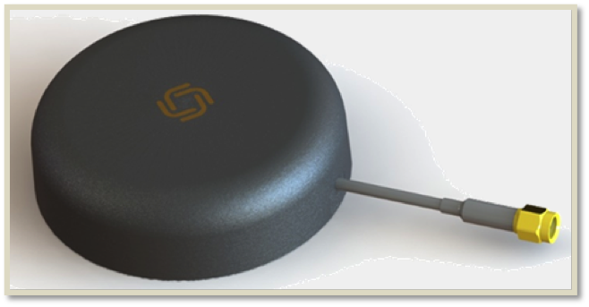
Allystar Technology Co. Ltd., headquartered in Shenzhen, China, is offering new patch antennas: the AGR6302 and AGR6303. Both GNSS antenna models are designed for precision dual-frequency positioning.
AGR6302 is capable of receiving L1/L2 bands, and AGR6303 is capable of receiving L1/L5 bands. They are designed for UAVs, precision agriculture, autonomous vehicles and other applications where precision matters.
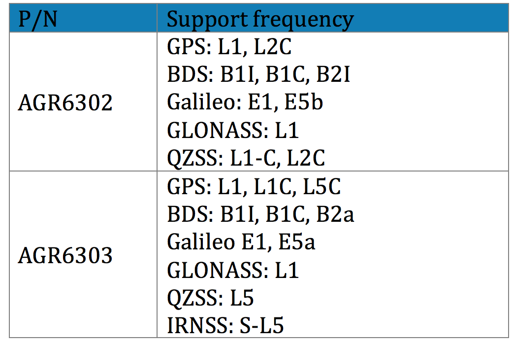
The AGR6302/AGR6303 active antenna is designed by unique technology to cover GPS, BDS, Galileo, GLONASS, IRNSS and the QZSS system (see table).
Table: Allystar
The antenna features stable signal quality at low cost. It employs a stack four-feeds antenna architecture with hybrid to achieve the multi-band operation, lower axial ratio, wider half-power beamwidth and excellent right-hand circular polarization, the company said.
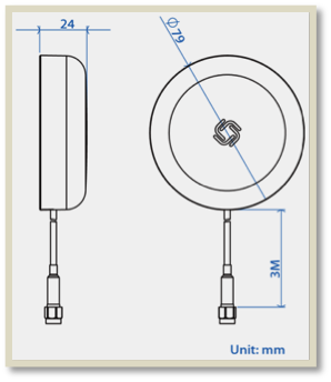
Antenna size. (Image: Allystar)
With its new architecture, the active part has two stages. It has two level low noise amplifiers (LNAs) —one for the lower bands, the other for the higher bands. Then, the combiner and the third-level LNA output the RF gain to receiver. With this architecture, the antenna provides an excellent noise figure/RF linear and LNA gain, and out-band rejection, resulting in good signal-to-noise ratio and anti-interference.
It is housed in a compact, industrial-grade waterproof and magnet mount enclosure. Using internal magnets, the antenna can be installed almost anywhere, allowing for greater flexibility.
In a unique car accident, a self-driving Tesla Model S hit and destroyed an autonomous Promobot, the robot model v4, on Jan. 6 in Las Vegas. The incident took place at 3000 Paradise Road, Las Vegas.
At 7 p.m., the Promobot’s engineers transported robots to the Vegas’s Congress Hall to prepare their booth at the Consumer Electronics Show, being held Jan. 8-11. All the robots were moving in a line. But one of them missed its way and drove to the roadway of the street parking lot.
At that moment, it was hit by a self driving Tesla car.
This video is property of Kevin Jenkinson, via Promobot.
After the clash, the robot was pushed aside and fell. The car continued to move and stopped 50 meters away from the accident. The passenger who was in the car while driving explains that he decided to try the self-driving mode (Full Self-Driving Capability) and chose an idle area for this test.
“There was nobody there, no men, no cars. I switched this Tesla into a self-driving mode and it started to move. And wow! A robot on the track! I thought the flivver would come round, but it bumped straightly into it! I am so sorry; the robot looks cute. And my sincere apologies to the engineers,” said George Caldera, a Tesla passenger.
As a result, the robot suffered serious damage. Parts of the body, the mechanisms of the arms, the movement platform and a head are destroyed. Now the robot is not able to take part in the exhibition and most likely there is no way to restore it.
This video is property of Steven Smith, via Promobot.
“Of course we are vexed. We brought this robot here from Philadelphia to participate at CES,” said Oleg Kivokurtsev, Promobot’s Development Director. “Now it neither cannot participate in the event not to be recovered. We will conduct an internal investigation and find out why the robot went to the roadway.”
The Tesla S reportedly uses the u-blox NEO-M8L GNSS chip. The company also in December 2018 received a patent for more accurate GNSS positioning using other vehicles as reference stations to share raw GNSS data and make positioning corrections.
Promobot is a manufacturer of autonomous service robots for business with development centers in Europe and Asia. Several hundred of Promobot robots operate in 26 countries around the world. They work as consultants, concierges, guides and administrators. At CES, Promobots will meet attendees at the Promobot booth, where it will give dance performances every hour.
The robot victim’s relatives have been notified. (Screenshot from video by Kevin Jenkinson)
Quectel Wireless Solutions has launched the EM20, an LTE Advanced Category 20 module with location.
The EM20 will debut at Quectel Stand #2115 during the Consumer Electronic Show taking place Jan. 8-11 in Las Vegas.
EM20 offers the maximum LTE throughput of 2.0-Gbps downlink and is optimized specially for Laptop, PC and high-speed industrial internet of things (IoT) applications, the company said.
The EM20 features Qualcomm IZat location technology Gen8C Lite (GPS, GLONASS, BeiDou, Galileo and QZSS). The integrated GNSS greatly simplifies product design, and provides quicker, more accurate and more dependable positioning capability, Quectel added.
Based on Qualcomm’s SDX24 chipset and fully compliant with 3GPP R13 specification, EM20 supports LTE wireless technologies such as up to 7 Carrier Aggregation (CA), 4×4 MIMO technology, 256-QAM as well as LAA (LTE Assistant Access) and CBRS (Citizen Broadband Radio System).
The new module supports FDD LTE frequency bands of B1/B2/B3/B4/B5/B7/B8/ B12/B13/B14/B17/B18/B19/B20/B25/B26/B28/B29/B30/B66 and TDD LTE bands of B38/39/B40/B41/B42/B43/B46 (LAA)/B48 (CBRS). This ensures that IoT devices with EM20 inside can operate on networks of nearly all the mainstream carriers worldwide.
Designed in M.2 form factor and measuring 42.0×30.0×2.3mm, EM20 is compatible with Quectel’s broad portfolio of LTE Advanced products including Cat 16 module EM16 and future 5G modules, which allow for smooth migration between different categories and to next-generation connectivity.
The EM20 is designed for ultra-high-speed laptop, PC, router, industrial gateway, in-vehicle video surveillance system, cloud-based 4K IP-camera and similar applications that require high throughput and low latency.
Regulus Cyber is showcasing its anti-spoofing GNSS receiver at the Consumer Electronics Show, being held Jan. 8-11 in Las Vegas.
Previously introduced in our Launchpad feature, the Regulus Cyber solves GNSS spoofing attacks that threaten the automotive, aviation, maritime and mobile industries with a unique technology applicable both as a fortified GNSS receiver, capable of detecting spoofing attacks, and at the chip level, allowing mobile phones, cars and internet of things (IoT) devices to receive GNSS spoofing protection for the first time, the company said.
The company was able to miniaturize its technology into a form factor that provides customers more flexibility with integration.
The Regulus Pyramid GNSS Receiver is a fully functional GNSS receiver, fortified with the spoofing detection capability. The receiver contains patented technology that enables it to differentiate between real GNSS signals and fake ones generated by an attacker.
The Pyramid GNSS receiver is a direct replacement to any automotive GNSS receiver. The upcoming chip-level technology offers both spoofing detection and spoofing mitigation to any GNSS-based device, including mobile phones, the company added.
The Spoofing Problem. Any vehicle guided by a GNSS system can be spoofed using open-source software and a software defined radio (SDR) legally purchased from Amazon for under $300. A spoofer can generate and transmit fake GNSS signals that can be used by the vehicle’s navigation system to calculate a false destination, directing the vehicle to an entirely different location, a potentially life-threatening hazard.
In addition, spoofing is a growing concern to any application or device that uses satellite positioning, navigation or time. While real attacks are expanding, anti-spoofing solutions remain a luxury that only high-end, defense markets can afford.
While current solutions are big, heavy and expensive, Pyramid GNSS offers industry-standard size and price. Industries such as automotive, aviation, maritime, and mobile phones can defend themselves against this sophisticated emerging threat, at an affordable price and relevant size, power consumption and weight, the company said.
“We designed our product to be a fraction of the size that is currently available on the market so that all types of companies – whether it is a car manufacturer or telecom provider relying on GNSS – can integrate it seamlessly,” said Yonatan Zur, CEO of Regulus Cyber. “GNSS spoofing will need to be a major security focus during 2019 since it leaves so many industries vulnerable to attacks.”
To meet Regulus Cyber at CES, visit booth #2602 at the Westgate.
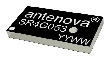
Antenova Ltd. has developed a new positioning antenna that it says can pinpoint a location to within centimeters in the GNSS bands. Antenova is a manufacturer of antennas and RF antenna modules for machine-to-machine and the internet of things.
Antenova will be showing samples of the Raptor antenna at the Consumer Electronics Show, being held Jan. 8-11 in Las Vegas, in booth #2220 in the Westgate hall.
The Raptor antenna utilizes the L2 1200-MHz satellite band that recently became available for civilian use.
The addition of the L2 frequency band combines multi-band satellite signal reception and GNSS correction data. This helps to mitigate position errors, greatly improving accuracy, especially in urban areas, the company said.
As well as improving tracking, the L2 band is beneficial for UAVs, drones, autonomous vehicles, agriculture, grid mapping and other emerging applications, Antenova added.
The antenna is the latest addition to Antenova’s lamiiANT range of rigid FR4 antennas which are designed for easy insertion onto a printed circuit board (PCB).
The antenna itself is very small. It is a GPS single-feed antenna in surface mount (SMD) form, measuring 16.0 x 8.0 x 1.6 millimeters, suitable for small PCBs within all kinds of small electronic devices.
“This is an outstanding antenna, because it achieves the same precision as a much larger, heavier ceramic patch antenna, but in a very compact SMD part,” said Colin Newman, CEO of Antenova. “A ceramic antenna would need to be 35 x 35 millimeters to achieve a similar level of accuracy and performance.” Raptor is supplied in tape and reel for ease in high-volume manufacturing applications.
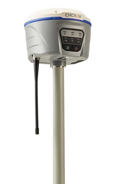
The i50 GNSS receiver comes bundled with the CHC HCE320 Android controller and CHC LandStar 7 field data collection software. (Photo: CHC Navigation)
CHC Navigation has unveiled its i50 GNSS receiver, an all-in-one GNSS RTK solution.
The GNSS receiver comes bundled with the CHC HCE320 Android controller and CHC LandStar 7 field data collection software. According to the company, it is a cost-effective solution for topographic and construction positioning tasks in land surveying, small- and medium-sized construction projects, and precision GIS data collection.
“The i50 GNSS is designed to match the demand of cost-conscious yet demanding professionals searching for one all-in-one GNSS RTK survey solution,” said Hans Huang, product manager of GNSS solutions for CHC Navigation. “By integrating field proven GNSS positioning and communication technologies in a compact and rugged unit, land surveyors will experience unmatched work flexibility in their daily field work with CHC i50.”
The National Geospatial-Intelligence Agency (NGA) has awarded GeoNorth Information Systems (GNIS) a five-year, $15 million contract for persistent surveillance services of the Arctic region. Lockheed Martin will provide a scalable geospatial processing platform to enable the surveillance project.
GNIS will leverage Lockheed Martin’s Rosetta technology, which includes a versatile and highly automated set of commercial and civil image processing tools that scale and adapt to deliver precision geospatial intelligence products to the NGA.
GNIS, a wholly owned subsidiary of the Tatitlek Corporation, an Alaska Native Village Corporation, will work with Lockheed Martin and the University of Alaska Fairbanks’ (UAF) Alaska Satellite Facility (ASF), under the banner of the Arctic GeoData Cooperative. GNIS and the partners will build, improve, monitor and maintain terrain elevation models of the Arctic region.
“The Arctic region has significant global implications for environmental, economic and security factors,” said Gil Metzger, director of Applied Research at Lockheed Martin. “It is critical that we document and monitor this demanding environment with the best technologies available. Lockheed Martin is proud to be part of this innovative cooperative that establishes both an operational domain awareness capability and a foundation for advanced research.”
The cooperative team will leverage each member’s unique expertise and capabilities to provide a one-of-a-kind solution to partners like the NGA.
As the prime contractor, GNIS will perform overall project management, conduct day-to-day operations and provide access to commercial remote-sensing platforms through its existing direct receiving station located at ASF.
UAF brings broad Arctic-related research and development, problem solving and the ability to refine existing scientific algorithms and methods to support specific project requirements.
Lockheed Martin’s Rosetta toolset will transform the large volumes of sensed data into correlated geospatial intelligence products.
“The Arctic domain poses many challenges,” said Jon Heinsius, general manager of GNIS. “Not only is it an area much larger than the whole United States and Canada combined, but its remoteness, intense weather conditions and unique characteristics are not found anywhere else in the world. The cooperative’s combined academic and commercial approach provides the NGA with tremendous flexibility to meet their current and future needs.”
“The cooperative is going to be a supportive environment where participants can bring ideas, technologies, algorithms and research for development, testing and validation,” said Nettie La Belle-Hamer, director of the Alaska Satellite Facility. “The concept is to explore and nurture new ideas to take what we learn today to build for tomorrow.”
Yang Changfeng, chief architect of China’s BeiDou navigation satellite system. (Photo: BeiDou)
By Yang Changfeng Chief Architect, BeiDou Navigation Satellite System
As one of the core GNSS, the BeiDou Navigation Satellite System (BDS) has been developed following a three-step development strategy. By around 2020, BDS will form a space constellation consisting of 30 satellites, including three satellites in geostationary earth orbit (GEO), three satellites in inclined geosynchronous satellite orbits (IGSO), and 24 satellites in medium earth orbits (MEO). It will provide free open and high-quality services, including navigation, positioning, timing, short message communication, search and rescue, and so on to the users worldwide.
In 2018, BDS has made fruitful results in the aspects of system construction, integrated applications, and international development.
System Construction
The stable operation of the BDS-2 constellation and construction of the BDS-3 constellation have resulted in solid achievements, while the deployment of the ground-based and satellite-based augmentation systems has made remarkable progress, and the International Multi-GNSS Monitoring and Assessment System (iGMAS) has been in stable and continuous operation
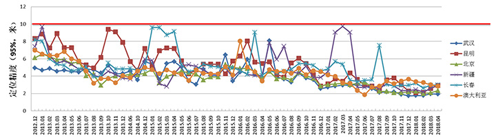
BDS-2 Improved Regional Services. Through upgrades and enhancements of the ground system, the service performance, stability and availability of the BDS-2 constellation has been improved. The analysis results shows that the nominal positioning accuracy of BDS-2 in its coverage area is better than 5 meters. To achieve user-oriented services, the Interface Control Document (ICD) for the open service signal B3I has been released.
The basic system of iGMAS has been completed, consisting of 24 ground stations and various centers, to provide raw data, basic products, and monitoring and assessment information services to users through the Internet and smartphones.
BDS-2 Positioning Performance. (Chart: BeiDou)
BDS-3 Constellation Deployment. By late 2018, 16 MEO BDS-3 satellites and 1 BDS-3 GEO satellite were in orbit. China successfully launched the 18th and 19th BDS satellites on Nov. 19. Deployment of the basic BDS-3 constellation has been accomplished.
The BDS-3 satellites are equipped with the higher-performance rubidium atomic clocks with stability of E-14 as well as hydrogen atomic clocks with stability of E-15. The signal-in-space (SIS) accuracy will be superior to 0.5m, the position accuracy will reach 2.5 to 5 meters, and the overall performance will be dramatically improved. The in-orbit test results have indicated that the BDS-3 satellites are in sound condition, and the performances can satisfy nominal parameters. For the convenience of public applications, the ICDs of the new signals, B1C and B2a, have been released.
BDS-3 will inherit the short message communication service from its predecessors, and will further enhance the basic PNT service capabilities. Satellite-Based Augmentation System (SBAS) and Search and Rescue (SAR) services will be developed according to the international standards.
Ground-Based Augmentation. The BDS/GNSS Ground-based Augmentation System has completed the deployment of 155 framework reference stations and nearly 2,400 regional stations in China. The system has carried out high-precision applications in many fields, such as surveying, national resources, disaster mitigation, transportation, meteorology, and offered basic services for users, including real-time navigation services at meter-level and decimeter-level, as well as precise positioning services at centimeter-level and millimeter-level.
China’s National Reference Station Network. (Image: BeiDou)
First SBAS GEO Satellite. The BeiDou Satellite-based Augmentation System (BDSBAS) is being developed in accordance with the International Civil Aviation Organization (ICAO) standards, to offer navigation services with superior accuracy and integrity.
In November 2018, the first GEO satellite with SBAS and SAR payloads has been successfully launched. The short message communication service offered by the satellite will be fully compatible with that of BDS-2, while the service volume will be increased by 10 times and the user’s transmit power will be reduced to 1/10. As the result, the user terminals will possess smaller size, higher integration and enhanced capacity.
Integrated Applications
As the system construction accelerates, BDS is also making great efforts to strengthen the development of fundamental products and applications in various fields. The integrated applications adopt the “BDS+” model, to stimulate the growth of satellite navigation industry.
Fundamental Products. At present, the fundamental BDS products have been used in mass market applications, of which the performance has reached or close-to the world-class level. By the 3rd quarter of 2018, the sales volume of BDS navigation chips and modules exceeded 70 million pieces, and the amount of the BDS-enabled terminals surpassed 500 million pieces or sets. In 2017, the domestic output value is more than RMB 250 billion (US $ 36 billion), in which the BDS contribution exceeds 80%.
Industrial Applications. BDS continues to facilitate the integrated applications and development of related industries; to bring GNSS high-precision services in combination with cloud computing, internet of things, big data and other technologies; to push forward the fusion among BDS-related industries and high-end manufacturing, software, integrated data industries, and to enable BDS-based applications to solve the problems associated with national economy and people’s livelihood. BDS has been integrated into various national significant infrastructures, by providing time and space references for transportation, meteorology, agriculture, electricity, communications, finance and other industries.
Meanwhile, “BDS+” and “Time and Space+” applications targeted towards the mass market are enjoying a broader future prospect. The BDS-based navigation services have been adopted by various enterprises in the fields of smart mobile terminal manufacture, location-based services (LBS), e-commerce, and so on. The BDS-based LBS have been widely use in the public consumption sector and people’s livelihood, which have been changing people’s life by providing more conveniences for the public.
BDS International Development. BDS continuously pushes forward international development, carries out practical cooperation and exchanges, and promotes the development of GNSS community, to better serve the world and benefit mankind.
BDS actively participates in related activities under the framework of the United Nations, other international organizations and multilateral platforms. In June, 2018, BDS took part in the UNISPACE+50 Exhibition and donated a BDS-3 satellite model to the United Nations Office for Outer Space Affairs.
In November 2018, the 13th Meeting of the International Committee on Global Navigation Satellite Systems (ICG-13) was successfully held in Xi’an, China. His Excellency Xi Jinping, President of the People’s Republic of China, sent a congratulatory letter to the ICG-13, and expressed that “China is willing to work with all countries, to share the construction and development achievements of BDS, and to jointly promote the development of global satellite navigation.” More than 400 representatives from 16 nations and 16 regional and international organizations attended the meeting and made in-depth exchanges on over 20 topics related to satellite navigation.
BDS has always been exploring joint applications with other compatible navigation satellite systems, and carrying out bilateral coordination and cooperation.
In November 2017, the Joint Statement of BDS and GPS Signal Compatibility and Interoperability was signed, which stated that the two systems were radio-frequency compatible within the framework of ITU, and BDS B1C civil signal and GPS L1C civil signal had achieved interoperability.
In November 2018, the Agreement between the Government of the People’s Republic of China and the Russian Federation on Cooperation in the Field of the Use of BDS and GLONASS for Peaceful Purposes was signed, which would facilitate the complementarity and integrated development, promote practical cooperation projects, and contribute to more efficient and reliable services for global users.
At present, BDS has covered more than 50 countries and over the population of 3 billion people. The BDS-related products have accessed to the markets of over 80 countries and regions. In April, 2018, the first overseas BDS/GNSS Center was opened by China Satellite Navigation Office and the Arab Information and Communication Technology Organization, to enrich the public awareness, experience and applications of BDS in Arab nations.
The international GNSS Monitoring and Assessment System (iGMAS) has contributed to the implementation of the Asia-Pacific Space Cooperation Organization project, iGMA-International GNSS Service Pilot experimental project, and Sino-Russian monitoring and assessment cooperation, and has provided GNSS users with authentic third-party assessment results.
Future Plans
BDS will continuously promote joint applications of multiple navigation satellite systems, and provide global users with diversified choices for better application experiences. BDS welcomes users and equipment providers worldwide to participate in the Global Users’ Experience and Evaluation Campaign (relevant information can be referred to the BDS official website), and will release the experience and evaluation results when appropriate.
By the end of 2018, BDS-3 will possess the initial operational capability and implement all-round validation on its global service performance. Between 2019 and 2020, BDS will keep improving its continuous stability and service accuracy, maintain the BDS-2 service performance stable and enhanced, and continue the BDS-3 deployment by launching another 6 MEO satellites, 3 IGSO satellites, and 2 GEO satellites, to eventually possess global service capabilities by 2020.
As part of ongoing global expansion, Microdrones has merged with Schübeler Technologies. Since its founding in 1997, Schübeler has built a global business by providing advanced fan propulsion jets and lightweight composite materials fabrication.
Offering a full product lineup of robust turbo fans, jets, compressors, pumps, electric motors, carbon fiber and aluminum composites, Schübeler products are designed to withstand extreme conditions and demanding field use. These components provide thrust power and lightweight durability to high-tech applications including UAVs, professional motorsports and heavy-duty outdoor equipment.
Microdrones, founded in 2005, has evolved from a manufacturer of commercial-grade unmanned VTOL aircraft to a provider of fully integrated systems for surveying, mapping, lidar and inspection applications. These systems are being put to use worldwide by professionals in the construction, mining, energy, agriculture and infrastructure trades.
“We make life easier for professionals by offering the full solution; it has proven to be a successful strategy,” said Microdrones President Vivien Heriard-Dubreuil. “Perfectly integrated drones, sensors, software, workflow, training and support is what the market needed. Welcoming the Schübeler team, talent and capabilities to Microdrones delivers new aviation technology and capabilities to our customers in the form of next generation unmanned aircraft.”
As the preferred provider of VTOL solutions to Trimble Dealers worldwide, Microdrones adds a global sales force and distribution network as well as technical centers and production sites spanning seven countries and three continents.
“Merging with Microdrones empowers us to develop and deliver systems where we can best support customers locally,” said Daniel Schübeler, founder and CEO of Schübeler Technologies. “This is a happy homecoming for me and the team that we’ve built over the past 20 years.”
Schübeler was an original founding partner in Microdrones and helped develop the pioneering technology that helped Microdrones gain global recognition for professional VTOL UAVs. He adds, “Both of these companies have enjoyed global growth and impressive technological advancements independently. Merging our talents and teams will yield amazing solutions in the years to come.”
“This is a strategic growth initiative,” explained Francois Gerner, SVP of Corporate Affairs at Microdrones. We are adding technology, IP, talent, strong leadership and investment capabilities that are complementary to both brands. This deal brings us to more than 150 highly skilled employees worldwide, which translates to better products, service and support.”
The merged companies will retain the Schübeler Technologies brand, which commands a niche’ audience of serious aeromodeling enthusiasts. Schübeler Technologies will continue to serve these markets as well as tackle large-scale custom R&D projects related to propulsion and materials.
After many years of development at the fringe of the GNSS industry, dual-frequency GNSS devices are finally ready to hit the mass market and will account for more than a billion chipset shipments in 2023, according to a new market data report by ABI Research.
ABI Research is a market-foresight advisory firm.
The report finds that the bulk of this growth will come from the adoption in the smartphone market with consumers hungry for better location accuracy.
Dual-band GNSS can mitigate the multipath interference effects, which are especially present in areas with a high density of buildings, like urban canyons, and deliver significantly higher accuracy than single-frequency devices.
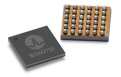
Broadcom’s BCM47755 chip. (Image: Broadcom)
However, several obstacles prevented widespread adoption of dual-band GNSS until now, including insufficient satellite coverage of a second band, which could be L2 or L5/E5, high chipset prices, and challenges in fitting these integrated circuits and related antennas into small devices such as smartphones.
“On the availability side, this year has seen several satellites launched into orbit every month, most of them fitted with L5/E5 capabilities, and the Chinese and European Union governments plan to have their satellite constellations fully operational by 2020. L5/E5 devices will not be left in the dark,” said Henrique Rocha, a research analyst for Location Technologies at ABI Research.
Furthermore, new breakthroughs from key chipset manufacturers are disrupting this market by overcoming the barriers to mass dual-frequency adoption. With Location-Based Services (LBS) applications in mind, Broadcom has released the BCM47755 dual-band location hub, claiming the system’s architecture achieves the synergistic benefits that cannot be reached by multiple integrated circuits (ICs), thereby reducing its overall size and power consumption.
Other important players in this market have also come forward with dual-frequency solutions, including Qualcomm with the Snapdragon X24 LTE modem and HiSilicon with the Kirin 980 system-on-a-chip. Both attribute their superior energy efficiency and form factor to intelligent data processing and a FinFET transistor design. Other chipset manufacturers such as MediaTek are expected to follow suit and present their own dual-band products for LBS.
The Xiaomi Mi 8. (Photo: Xiaomi)
At the consumer level, considering the handset market is the largest GNSS segment, accounting for 85 percent of all GNSS chipset shipments in 2018, the launch of the dual-frequency Xiaomi Mi 8, Xiaomi Mi Mix 3 and the Huawei Mate 20 following such breakthroughs in the chipset industry is a significant development because it opens a new lane of competition between smartphone manufacturers.
It is expected that dual-frequency devices will dominate the high-end smartphone market in a matter of a few years, and by 2023 dual-band GNSS ICs will comprise 36% of total GNSS LBS IC shipments worldwide.
Triple-frequency chips. In other significant markets for multi-frequency GNSS, such as surveying and automotive applications, triple-frequency chipsets are being released, including STMicroelectronics’ TeseoAPP and u-blox’s F9. Adding a third frequency allows for better noise correction and higher accuracy compared to dual-frequency.
Image: u-blox
ABI Research believes that triple-frequency devices will see, at least for now, a relatively shy adoption as manufacturers will need to justify the cost and overcome the power issues they tackled for dual-frequency devices.
“For LBS the comparatively small accuracy gain going from dual- to triple-frequency GNSS is not worth the extra effort — for now. However, we will probably see triple-frequency GNSS take off when cars fitted with advanced driver assistance and autonomous driving systems begin to ship in large quantities,” added Rocha.
With full satellite operability of the main GNSS bands on the horizon and chipset manufacturers overcoming past hurdles for implementing dual-frequency solutions, it is likely a matter of time before most major companies in the segment scramble for a piece of this promising market. OEMs now need to show customers that dual-frequency GNSS can indeed deliver the accuracy they have promised so new location use cases can be sustained and introduced to the market.
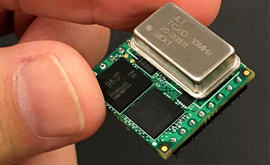
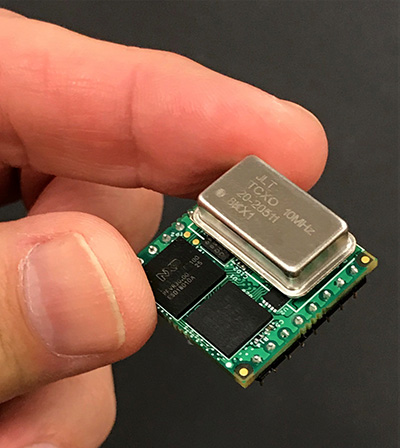
Jackson Labs Technologies Inc. (JLT) released its tiny, new Micro-Transcoder, a full-constellation, stand-alone, real-time 10-channel GPS simulator. The unit can act as a GPS firewall to identify and block jamming and spoofing attempts, and to provide an alternate PNT source during fully GPS-denied operation.
JLT is a designer and manufacturer of GNSS, timing and frequency equipment.
Photo: JLT
The one-inch-square Micro-Transcoder module allows glueless retrofitting of existing GPS equipment by upgrading systems with secure and assured positioning, navigation and timing (PNT) capability, the company said. It achieves hardening of the customers’ GPS equipment by splicing the unit in between the existing antenna and the users’ GPS receiver.
It takes the output of any secure PNT source — inertial navigation system (INS), SAASM, M-code, Iridium STL, or concurrent GNSS receiver — and encodes (RF modulates) the baseband PNT and UTC timing information into a standard GPS L1 RF signal.
This RF signal can then be received by any legacy GPS receiver.
The unit is based on JLT’s CLAW GPS simulator and RSR transcoder technologies, and includes a stand-alone full-constellation 10-channels real-time GPS simulator with integrated high-stability timing reference, as well as an internal GNSS receiver for monitoring the RF output signal for quality and accuracy.
The unit will transmit a standard UTC time, position, velocity and heading GPS L1 RF signal by simply applying 3.3V power to it.
The Micro-Transcoder can also be operated as a generic high-performance GPS simulator with built-in GPS Disciplined Oscillator, and is supported by a comprehensive free Windows application program downloadable from the JLT website.
The Windows application allows control of all the simulation aspects, creating and storing simulation vector commands, and testing user equipment for leap-second and GPS week rollover event compatibility to identify weaknesses in user equipment.
The unit does not require a PC to be connected to it to function. This makes embedded operation as easy as applying power, and connecting the units’ RF output to the antenna input of any GPS receiver.
By generating a legacy RF GPS signal from any secure PNT source, the Micro-Transcoder allows users to maintain their investment in fielded legacy GPS equipment. Example applications include retrofitting financial transaction time servers with CSAC or rubidium atomic clock holdover capability, and adding GPS RF output capability to concurrent GNSS receivers to allow reception of L1, L2, L3, L5 GPS, GLONASS, Galileo, BeiDou, QZSS, Iridium STL, or any other satellite-based navigation signal to legacy GPS receivers.
It can also be used to add inertial navigation system (INS) capability to vehicles and aircraft.
None of these applications require any modifications to be made to the legacy GPS receiver system; all configurations are done externally using the Micro-Transcoder Windows application or a standard terminal program, and on the assured PNT source.
A real-world customer application is a data-center where communications equipment required a GPS signal to operate. The user wanted to prevent vulnerabilities that an external antenna would have introduced. In this scenario, the Micro-Transcoder provided a fixed-position GPS RF signal to a number of the data centers’ GPS receivers, and allowed the GPS user equipment to operate properly without exposing it to the possibility of external jamming or spoofing.
At 0.97 x 0.97 x 0.4 inches and with less than 0.95W power consumption, the Micro-Transcoder is small enough to be designed into emerging assured PNT products, allowing them to communicate gluelessly to existing legacy GPS infrastructure.
The Septentrio team poses with the Products Leadership Award. (Photo: Septentrio)
The Septentrio team — including Andrew Simsky, navigation algorithms software engineer; Wim De Wilde, system designer; Jean-Marie Sleewaegen, system architect; and Tom Willems, senior researcher — received the 2018 GPS World Products Leadership Award for developing the versatile PolaRx5 receivers, enabling many Earth-observing applications including worldwide ionosphere monitoring. Sleewaegen offers the team’s acceptance speech below.
It is a great honor and privilege to be here and we are very happy to receive this wonderful award. On behalf of my colleagues Tom, Andrew and Wim, and the entire Septentrio team in Belgium, I would like to thank Alan and all sponsors and organizers of this dinner.
From the beginning, Septentrio enjoyed close ties with the scientific community, and we continue to cherish this connection. Our PolaRx receivers, and especially our ionosphere monitoring receiver, is the result of a close collaboration with scientists at universities and research institutes around the world, some of them present here. While the GNSS industry was and is still largely relying on legacy L1 signals, they have been early adopters of all new signals and constellations. For us, this has been a great motivation to implement support for all signals and frequencies at the earliest stage of availability.
Ionosphere scientists are special folks. While most of us dream of getting rid of error sources, they just focus on them, and more specifically on small delays and variations caused by the atmosphere. They don’t want us to filter out these perturbations. On the contrary, they want to see them in their full glory. But the problem is, there are plenty of other error sources. Multipath, clock jitter, vibrations, hardware biases, interference are all out there and are hard to distinguish from what the ionosphere is doing. Our challenge was to minimize those noises and biases to extract the underlying physical signals. This exercise was really instructive, and this technology which we developed for the scientific community is now in the heart of all our receivers.
Looking ahead, while the avalanche of new signals and satellites is an opportunity, it is also a huge challenge. In some regions, we can already track more than 60 GNSS satellites, all transmitting multiple signals, and this number will only keep growing.
How to use all this information? What is the optimal set of signals for a certain application? Are these signals all useful? With the many tracking options, how to guarantee compatibility between vendors? Many open questions still remain to be answered and will keep us busy for the years to come.
We really appreciate the opportunity to be here, thank you for listening!