MEMS-based sensing solutions company Acienna released OpenIMU, a professionally supported, open-source GPS/GNSS-aided inertial navigation software stack for low-cost precise navigation applications.
Integrating an inertial measurement unit (IMU)-based sensor network will greatly improve its navigation and self-location capabilities, Acienna said.
It is aimed at developing autonomously guided vehicles for industrial applications, autonomous cars, factory or industrial robots, drones, remotely operated underwater vehicle or any kind of smart machine that needs to move fast or slow, on land, in the air or in water.
“Our breakthrough open-source software for INS/GPS algorithm development is the first professional grade open-source navigation stack running on a low-cost IMU,” said Mike Horton, CTO of Aceinna. “Not only will this kit save developers time and money, it is simple to use and does not require a Ph.D.”
OpenIMU enables advanced, easy-to-deploy localization and navigation algorithm solutions for a fraction of the time and cost of traditional methods, Aceinna said.
OpenIMU’s combination of open-source software and low-cost hardware enables rapid development of advanced solutions for drones, robotics, and autonomous applications. Its extensible software-infrastructure provides all the code needed for algorithm development.
The freely downloadable stack includes:
FreeRTOS-based data collection and sampling engine
Free IDE/compiler tool chain based on Visual Studio Code
JTAG debugging for debugging code loaded on IMU
Data logging, graphing, Allen Variance plots and maps
Extensive documentation
Robust simulation environment with advanced sensor error models
To install OpenIMU stack now, follow the directions. Several ready-to-install free GPS/INS and IMU applications are available at Aceinna’s Navigation app store.
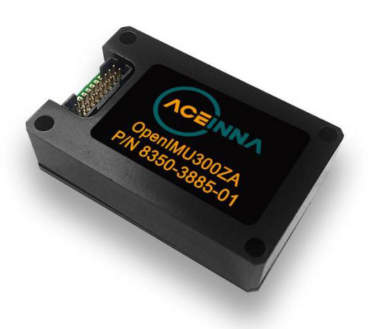
The OpenIMU Development hardware development kit includes JTAG-pod, precision mount fixture, EVB and an OpenIMU300 module.
The OpenIMU module features Aceinna’s 5 deg/Hr, 9-Axis gyro, accelerometer, and magnetometer sensor suite with an onboard 180-MHz ARM Coretex floating-point CPU.
The IMU is delivered in a 24 x 37 x 9.5 millimeter module that operates at 2.7-5.5 VDC.
The OpenIMU Development kit is available for immediate delivery.
Spry Drone briefly submerges under water to flip on its belly then fly in the air like a bird (PRNewsfoto/Urban Drones)
SwellPro USA and Urban Drones have released a waterproof drone, the Spry, that can briefly submerge like a submarine, float like a boat and fly in the air at over 43 mph.
The Spry features a self-contained camera that can capture video at 30 frames per second and pictures at 12 megapixels. According to the company, the Spry gives users the ability to capture high-resolution video and pictures without compromising speed and agility. It can also wirelessly transmit the video signals to a monitor embedded in its waterproof remote control.
The Spry’s GPS can be activated from the remote control, which has an integrated 4.3-inch monitor to view the Spry’s live video feed. It also boasts advanced flight features, such as hold position, auto follow, object orbit and return to pilot’s position.
“The Spry’s ability to submerge under water and fly in the air makes it the most versatile drone ever created,” said Alex Rodriguez, CEO at Urban Drones. “We’ve only seen this in science fiction movies.”
Urban Drones is a drone technology company located in Florida and SwellPro USA’s partner in the Spry project.
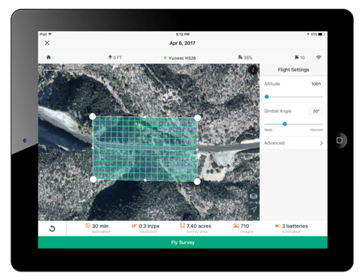
3DR, makers of Site Scan, has partnered with Esri to develop Site Scan Esri Edition, a custom version of its iOS app for drone flight planning and data capture that works seamlessly with Esri’s ArcGIS Online and Drone2Map for ArcGIS.
The Site Scan Esri Edition app will complement Esri’s Drone2Map for ArcGIS software by providing full drone project mission planning and a simple workflow for transferring drone captured data into the Esri ArcGIS ecosystem.
Screenshot: 3DR and Esri
Users will be able to connect to ArcGIS Online with an Esri sign-in. The app will allow users to directly use Esri data layers from ArcGIS Online — including custom data layers from the user’s FedRAMP authorized ArcGIS Online organization account — as base and reference data for their drone flight planning mission.
Esri customers can use any drone currently supported by Site Scan, including a variety of DJI drones. Site Scan also supports a custom version of the new Yuneec H520 commercial drone by 3D, which is based on the Dronecode PX4 software and designed to be an open and secure drone option for use on U.S. government projects.
“I’m thrilled that we’ve been able to work with Esri to provide its users with flight planning and drone capture tools,” said Chris Anderson, CEO of 3DR.
“3DR has been a leader in the drone industry, and we are excited to support this development effort,” said Cody Benkelman, imagery product manager at Esri. “A drone flight planning app that connects directly to ArcGIS Online will provide great value to Esri’s worldwide customer base, and simplify the process of ensuring successful projects using Drone2Map.”
Site Scan Esri Edition app will be available on the Esri Marketplace in late September for free to ArcGIS customers.
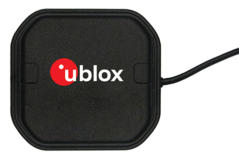
U-blox, a global provider of positioning and wireless communication technologies, has released the ANN-MB multi‑band active GNSS antennas, tailored specifically to the needs of applications requiring centimeter-level positioning accuracies.
The ANN-MB series. (Photo: u-blox)
ANN-MB offers product designers an easy-to-implement and reliable multi-band antenna solution, u-blox said. It is designed for small- to medium-size customers with little experience with GNSS antennas who would like to accelerate their time to market.
The ANN-MB antenna series builds on u‑blox’s two decades’ worth of experience with high-performance antennas for GNSS receivers. Developed in conjunction with the recently announced u‑blox F9 multi-band high precision positioning platform, ANN‑MB receives signals on the L1 and L2/L5 bands of all four global navigation satellite constellations (GPS, GLONASS, Galileo and BeiDou).
The antenna features versatile mounting and connector options (SMA, SMB, MCX) and supports an extended temperature range (up to 105 degrees Celsius), making it suitable for applications subject to extreme temperatures, the company added.
“With the u‑blox F9 platform, we took a major step in bringing down the cost of ownership of high-precision GNSS technology, such as our recently announced u‑blox ZED‑F9P module,” said JunJun Lu, senior engineer of product management, Product Center Positioning at u‑blox. “The ANN-MB multi-band antenna series takes this effort one step further, paving the way for new high precision positioning applications in the consumer and industrial markets.”
A limited number of ANN-MB-00 (SMA) prototypes are available now, with production of the ANN-MB series planned for December.
A link to the live event will be sent to you two hours before the event. Your personalized event URL will be automatically generated by the ON24 system. To ensure receipt of the email, please whitelist this email address by adding it to your contacts: [email protected].
This presentation will begin on at 1 p.m. EDT / 10 a.m. PST on Thursday, September 20, 2018.
Audience members may arrive 15 minutes prior to live time. If you have any questions, please contact event producer Grace Rybak at [email protected].
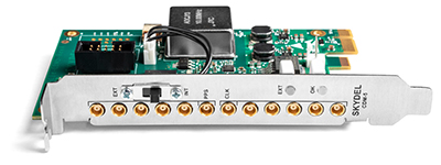
Skydel has released a new clock distribution module for the GNSS industry.
Photo: Skydel
Designed in a PCIe card format, the CDM-5 is a compact and precise clock intended for use with GNSS and other RF systems. It can synchronize up to five devices and can be integrated into custom hardware systems.
Skydel’s CDM-5 provides 10-MHz and 1-PPS signals for up to five devices that need tight and precise synchronization. It is suitable for PCIe-based software-defined radios (SDR) installed in rackmount or desktop PCs, and also can be used for any other applications that require a precise PC-based timing reference.
Skydel’s CDM-5 clock distribution module features two operating modes—internal or external— that are selected with the bracket-mounted switch.
In internal mode, the CMD-5’s internal clock signal is extracted from the onboard high-grade oven-controlled crystal oscillator (OCXO).
When operating in external mode, CDM-5 accepts input signals in the form of 10-MHz and 1-PPS, which are then redistributed via five matched-length traces. Split signals are amplified to maintain the power level across all distributed paths.
Additionally, CDM-5 will regenerate 1 PPS from an external 10-MHz-only source if a 1-PPS source is not available.
The CDM-5 can be integrated into a custom assembly by removing the bracket plate and powering the board through its 12V DC connector. When the bracket is removed, the operating mode can be toggled using the onboard switch.
Key features:
Timing and frequency source with five-way distribution of 10-MHz and 1-PPS signals
PCIe form factor for rackmount or desktop PC
Two operating modes: internal clock (OCXO) or external clock (10MHz and 1PPS)
Supports standalone operation with 12V DC power supply
Drone company PrecisionHawk has announced a partnership with EagleView, a provider of aerial imagery and data analytics for government, insurance and commercial sectors.
PrecisionHawk also announced that it has purchased both HAZON Inc. and InspecTools Inc., businesses that specialize in the delivery of inspection services and technology for the energy industry.
Both companies bring demonstrated expertise to enable tighter integration between the collection and the analysis of drone data, PrecisionHawk said. Paul Bingaman, CEO of InspecTools, and David Culler, CEO of HAZON, will join PrecisionHawk’s executive leadership team.
EagleView partnership for insurance claims
EagleView’s partnership with PrecisionHawk enables drone insurance inspections. (Photo: PrecisionHawk)
Through the partnership with PrecisionHawk, EagleView will collect at-scale insurance claims imagery via drones by leveraging PrecisionHawk’s global network of drone pilots, Droners.io.
The addition of PrecisionHawk’s drone pilot network will benefit EagleView OnSite Solutions for remote claims inspection. EagleView OnSite virtual desk adjustment combines imagery from multiple sources, including drones, with a variety of data analytics and reports to enable adjusters to efficiently triage claims, virtually inspect properties from their desk, and ultimately close property and casualty (P&C) claims faster.
“EagleView OnSite provides insurance customers with all the tools necessary to settle claims without ever going into the field,” said Rishi Daga, CEO of EagleView. “As drones transform the way the insurance industry operates, making inspections safer, easier and more cost effective, EagleView reinforces its commitment to drone technology to digitize manual workflows.”
Virtual drone inspections for insurance claims address a challenging trend in the P&C insurance industry. Over the past 20 years, the number of experienced insurance adjusters has dropped dramatically, causing labor shortages — especially after major storms hit. The demand for insurance adjusters is high, yet drone pilots add a new, untapped “labor force” to the equation.
Combining the EagleView OnSite virtual desk adjustment solution with PrecisionHawk will offer the insurance industry thousands of certified, trained drone pilots to perform high-quality insurance inspections at a competitive cost. With more than 25,000 claims processed by EagleView OnSite in the last 18 months, EagleView can help insurance carriers transform their property claim workflows and decrease cycle time by at least 40 percent to best serve their customers after a catastrophic natural disaster.
Drone technology and analytics for the energy market
HAZON brings extensive aviation experience, standards-based operating procedures, certified drone flight operations and inspection services, widely regarded as the best in the energy industry, to the PrecisionHawk team. The company has delivered more than 13,000 inspections totaling over 8,000 hours of flight time, with a majority focused in energy markets for Fortune 500 utilities.
InspecTools brings high-fidelity machine vision software and data analysis tools built for the renewable energy market. Their market-leading software for both solar-panel and wind-turbine inspection is utilized by some of the largest equipment manufacturers and service providers in the world. Customers like Vestas, PG&E and SMA Solar rely on InspecTools’ sophisticated reporting, analytics and machine learning capabilities.
“We’re very pleased to bring together the established technology and multi-market reputation of HAZON and InspecTools with PrecisionHawk’s experience, team and expanded portfolio,” said Michael Chasen, CEO of PrecisionHawk. “By combining these offerings, our customers will have access to extensive and leading-edge energy products and services, regulatory expertise and a record of safe, secure and compliant operations.”
Thanks to advances in technology and regulations, the energy market has quickly moved from experimenting with pilot projects to large scale deployment of drone solutions, PrecisionHawk said. Across distribution lines, transmission lines, solar panels, wind turbines, oil and gas and utility infrastructure, and emergency response, energy presents a current global market opportunity of $9.7 billion.
According to IDC, worldwide spending on robotics and drones will accelerate over the next four years reaching $201.3 billion in 2022. While the value is clear across time, safety improvements and operational efficiency, scaling and managing a drone program can be complex.
“HAZON is excited to bring our world-class best practices and reputation for standards-based operations and safety to the PrecisionHawk team,” said Culler. “By joining PrecisionHawk, our customers gain access to the next level of technological sophistication for more scalable, predictive and cost-efficient drone solutions that drive better business intelligence.”
“InspecTools brings years of experience, analytics tools and machine vision software for renewable energy that is an immediate value-add to PrecisionHawk’s software analytics platform,” Bingaman said. “This relationship further enhances the technologies and services that are fundamental to advancing the economic potential of drones in the energy market.”
The acquisition of HAZON and InspecTools underscores PrecisionHawk’s strategy to operate in high-growth markets and accelerate the adoption of commercial drones.
The acquisitions, which are subject to customary closing conditions, are expected to close later this month.
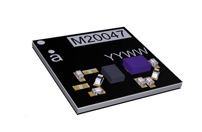
Antenova is shipping its ultra-small GNSS active antenna module for tiny positioning devices, the RADIONOVA M20047-1. The antenna module includes a low noise amplifier (LNA) and surface acoustic wave (SAW) filter for better positioning from difficult locations.
Antenova Ltd. is a manufacturer of antennas and RF antenna modules for connected devices and the internet of things.
The RADIONOVA M20047-1 is designed for small consumer devices such as smartwatches. (Photo: Antenova)
The RADIONOVA M20047-1 is an active antenna module for GNSS applications in the 1559-1609 MHz satellite bands using GPS, GLONASS, Galileo or BeiDou.
The M20047-1 antenna module comprises an SMD antenna with built-in active components: an LNA filter and SAW to boost antenna performance — so designers will not need to add these — contained in a compact FR4 part with low power consumption, measuring 7.0 x 7.0 x 0.9 millimeters and weighing less than 2 grams.
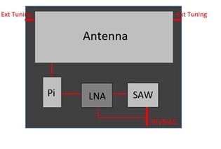
The onboard LNA and SAW filter act to boost the signal to the GNSS processor in environments where there is a restricted view of the sky or where line-of-sight to the horizon is difficult, the company said.
Architecture of the Antenova antenna. (Image: Antenova)
Antenova has also added an external matching feature to compensate for any de-tuning of the antenna caused by proximity to other components, such as a plastic case or a battery.
The clear-out area required by the antenna module is only 7.0 x 5.0 millimeters. This, with its tiny size, makes the M20047-1 suitable for small positioning devices where space on the PCB is tight, such as wearable devices, asset tracking devices, sports cameras and equipment and smartwatches.
The M20047-1 is an alternative to Antenova’s Sinica antenna (part no. SR4G008), which Antenova also recommends for accurate positioning.
The M20047-1 was first announced at the Consumer Electronics Show in Las Vegas in January.
Antenova’s antennas are specifically designed for easy integration. The datasheet and evaluation kit for the M20047-1 are available from www.antenova.com. Antenova also provides full engineering support, antenna testing, tuning and integration for its customers.
There’s a saying that “Time stops everything from happening at once” — but what if it doesn’t?
What if we are in a world in which the U.S. is borrowing growth from the future by increasing debt, China has slowing growth and risky finances, many developing and southern European countries have combinations of economic malaise, recession, high and rising debt and/or double-digit inflation, the U.S. is in disruptive trade negotiations and Britannia waves the rules?
With the widespread influence of GNSS and the many technologies with which it is now associated or integrated, attention is increasingly turning to the prospects for and nature of applications, where the platform is the message.
At the same time, economic, political and technological developments are leading to pressing issues in the areas of spectrum management, spoofing and jamming, cybersecurity, privacy, net neutrality, spectrum competition, national security export controls, product liability, space debris and crowding and militarization of space.
This environment places unprecedented demands on management attention and agility.
The structure of industries is being transformed. Mergers and acquisitions are reminiscent of the U.S. consolidation of the 1960s, which led to increasing market power among large corporations until economic weakness and new technologies disrupted the leaders.
This time the changes are taking place on a much more global scale, but nevertheless are becoming large enough to influence markets and competition in location-based sectors and other industries.
Describe the market for GNSS products/services in your industry sector as of today. (Source: GPS World 2018 State of the Industry survey)
Market Intelligence. Executives will need good market intelligence and foresight to keep ahead of fast-developing technology trends in research and development and shifting markets.
Despite opportunities from renewed economic growth, decisions regarding capital spending and research and development face not only the usual uncertainties about economic paths, interest rates and markets but also an additional extraordinary range of risks across the globe. These range from military and economic warfare, terrorism and hostage taking to financial excesses to appropriation of intellectual property and state subsidies by competing nations.
In the U.S., where politics is highly polarized, upcoming congressional and presidential elections will certainly lead to large, unexpected changes. U.S. policies could be extended or reversed, depending on election outcomes, in the areas of taxation, regulation, and levels of defense spending, with implications for modernization of GPS satellites, ground systems and military user equipment.
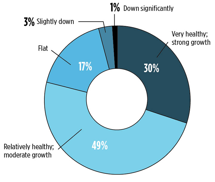
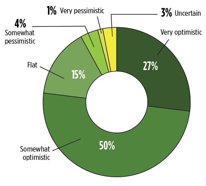
What is your business outlook for 2019? (Source: GPS World 2018 State of the Industry survey)
Population Factor. The workplace will have to adjust to further slow population growth. With half of baby boomers yet to retire, job opportunities will continue to be above normal, but so will losses of some skills. The availability of scientific and engineering personnel also will be affected by immigration policies for a long time. In addition, tight labor markets mean issues of labor quality as well as skill.
Moreover, social and political issues in the workplace are becoming more contentious around race relations, gender equality, sexual harassment, privacy and fairness, with some tech employees pressing companies to reject some types of government business.
Europe. In the U.K., choice of a hard Brexit could be disruptive for many years despite some possible long-range benefits. There is no getting around the need to renegotiate vast numbers of restrictions, policies and standards. A “soft Brexit” does not appear likely to yield the hoped-for economic benefits of separation and will not fully reduce the costs of the rift.
The European Union faces the challenge of paying for Galileo and other defense and space programs as well as costly social programs without the contributions of the U.K. At the same time, increased populism is leading to unexpected changes in governments and policies that can reduce cooperation among nations.
Currency. A strong dollar and rising interest rates in advanced countries can create problems for emerging economies. Trade and currency fluctuations complicate supplier decisions about pricing and the location of production.
The leaders of China and Russia are entrenched, and in the absence of major economic disruptions they will be able to carry out policies without periodic reversals. China’s ascendancy in technology, including in GNSS and space, will increasingly challenge the West.
Trade. Politics and economics are joined at the hip, and no less so when it comes to trade. The question at the moment is whether tough trade negotiation tactics will devolve into a sustained trade war, undoing the benefits of the U.S. tax cuts and bringing economic harm to the rest of the world.
The international Monetary Fund warns that: “Our modeling suggests that if current trade policy threats are realized and business confidence falls as a result, global output could be about 0.5 percent below current projections by 2020.” While some see trade tensions, nationalism and populism as the start of an effort to renegotiate the world order, for now developments are likely to be much less far-reaching.
While the U.S. economy is currently strong and likely to remain so for a while, risks have been building and economic and financial cycles have not been repealed. Budget pressures from future economic and political reversals can stall spending on defense, space and GNSS, defer GNSS capabilities and stretch deployment schedules.
All this means turbulence and air pockets down the road. Fasten your seatbelt. FY 2019 is about to take off.
For more results from the 2018 State of the GNSS Industry, see this page.
As precision guidance, autonomous operations, high-definition geocoded images and high-volume data processing all improve, drone use will continue to increase. OEM receiver manufacturers, sensor suppliers and data-handling companies play key roles in development, and stand to profit thereby.
In particular, use of drones is growing in land management, construction, mining, and farming. An open-pit mine operation can be supported through detailed drone inspection producing high-resolution images. Processed images and data enable keeping tabs on inventory, site changes over time, identifying best areas for further extraction, and monitoring and managing vehicle movement. These tasks required huge amounts of time in the past. Drone overflight and processing tools condense all the effort as well as producing enhanced results to enable faster and clearer decision-making.
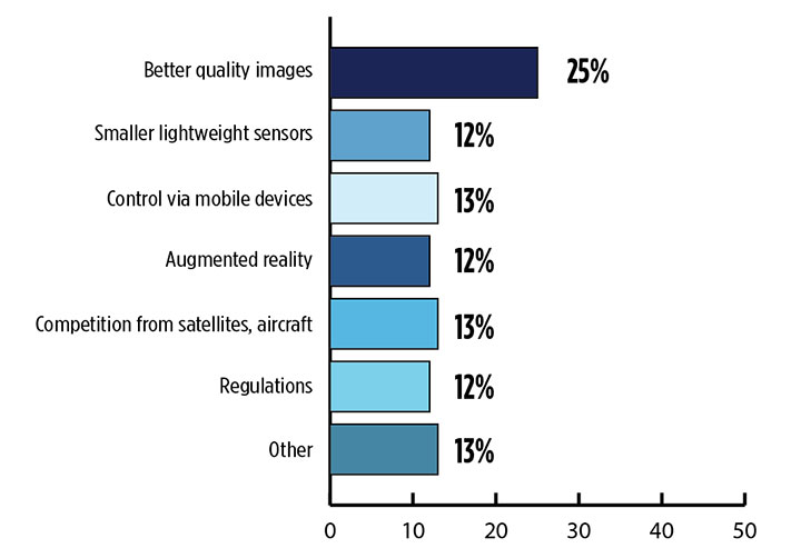
What is the biggest challenge for the UAV industry? (Source: GPS World 2018 State of the Industry survey)
Defense. Surveillance and reconnaissance are probably the biggest military drone applications. Carrying payloads that include color video cameras and infrared night vision cameras, more than 19,000 drones are now in the arsenal of the U.S. Army, Air Force, Marines and Special Ops, and more have gone to other nations’ militaries.
Flying at relatively low altitude, with somewhat limited range and powered by a single quiet electric motor, these drones have become essential in gathering forward-situation intelligence.
Other UAV craft provide higher altitude, longer-duration surveillance and reconnaissance over wider range: up to 20 hours, up to 15,000 feet, more than 60 miles afield. Civilian versions of these craft are in development.
Delivery. Respondents to our survey thought delivery will be a breakthrough application for drones. Amazon has several trials running globably. National civil aviation authorities need to move forward with plans to integrate drones into civilian airspace for this initiative to graduate to full-scale operations and achieve their objective of 30 minutes from order to delivery.
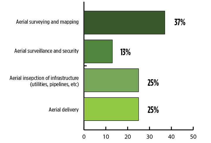
What is the killer app for drones? What professional UAV market sector will most powerfully drive adoption and influence new regulations for unmanned aerial vehicles? (Source: GPS World 2018 State of the Industry survey)
Precision Agriculture. One of the most significant applications which seems to be missing from survey responses is agriculture. Both quadcopters and hybrid fixed-wing/copter drones are in widespread use to capture image data overflying crops, and then process the data and build crop analytics. Graphic results point to how crops can be managed to increase yield.
Making this work is a combination of sensor payloads gathering visual, video, lidar, thermal and hyperspectral data; the secret sauce lies in how the data is processed and presented to farmers. Emphasis is placed on exactly how “green” crops appear when inspected by the various sensors. A number of companies offer services for farmers to optimize crop management.
All these areas are show significant drone growth. Let’s not forget facility, transmission line and pipeline inspection — tasks where drones excel at increasing efficiency and decreasing costs.
For more results from the 2018 State of the GNSS Industry, see this page.
Tony Murfin is a GNSS aerospace consultant with several decades experience at leading companies in the GPS/aviation and OEM sectors.
According to SimActive, users can now process raw data, produce point clouds and digital surface models, and perform volumetric calculations with the Correlator3D workflow. (Photo: SimActive)
SimActive has updated its Correlator3D end-to-end photogrammetry software to include tools for users to generate precise statistics on mining activities, with improved volumetric calculation.
The integrated tools allow users to generate precise statistics on mining activities.
The Correlator3D software performs aerial triangulation and produces dense digital surface models, digital terrain models, point clouds, orthomosaics and vectorized 3D features.
Applications like mineral extraction monitoring can be done seamlessly within the software.
Users can process raw drone data, produce point clouds and DSMs, and perform volumetric calculations in the same Correlator3D workflow.
“Our clients often require project delivery within 24 hours”, said Jennifer Waugh, principal at Alietum Ltd., a Canadian company using unmanned technology to support construction, consulting and government clients. “SimActive enables us to meet this demanding turnaround time.”
Based in Montreal, Quebec City, Canada, SimActive has been a developer of photogrammetry software since 2003.