The inaugural European Drone Summit will be taking place Oct. 15 in Frankfurt, Germany.
According to event sponsor UAV DACH e.V., the conference will give operators, manufacturers and public authority representatives the chance to gather and discuss the potential modes of operation and applications that are opening up for professional drone service providers and companies in light of the unmanned aircraft industry’s new European general aviation regulation.
Keynote speakers at the event will include Peter van Blyenburgh, UVSI; Max Scheck, Vereinigung Cockpit; Jules Kneepkens, EASA a.D.; Martin Brandenburg, DJI; Andreas Lamprecht, AIRMAP; and Jörg Seebach, DeDrone. The Intel Drone Group’s Anil Nanduri will also present a keynote speech.
“We are delighted that high-ranking experts from different companies, some of whom are even competitors, have accepted our invitation to come on board,” said Michael Wieland from UAV DACH e.V. “Global players’ first-hand experience and solutions offer added value to everyone taking part.”
The goal of the European Drone Summit is to channel ideas and decisions relating to unmanned aircraft systems (UAS) in order to highlight how unmanned aerial vehicle technology can be used now and in the future by representatives of various sectors, organizers said. The summit will take place at the same time as Intergeo, which will take place Oct. 16-18.
The next generation of mobile network architectures promises increasing speeds and lower latency for the ever-expanding base of users and the constantly growing data volumes transmitted.
In order to deploy this next generation (5G), the network must be densified. Densification implies more cell sites in more locations and getting the signal closer to the users. This in turn places more stringent requirements on network synchronization to achieve these goals.
Network time and phase synchronization below 100 ns accuracy is critical for the low-latency requirements of 5G networks. As wireless carriers gear up for deployment, new digital GPS repeaters can ensure wireless networks are 5G-ready.
A free webinar this Thursday, Sept. 6, will review different methods of achieving frequency, phase and time synchronization in advanced communication networks, including 5G commercial wireless applications. Join two technical experts as they discuss the requirements for 4G and 5G network synchronization, the role of GPS/GNSS signals in synchronization and the different types of synch architectures.
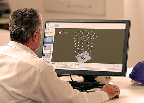
MAGNET Inspect is designed for UAV data collection. (Photo: Topcon)
Topcon Positioning Group has introduced software to facilitate the data-processing workflow for UAV (unmanned aerial vehicle) infrastructure inspection.
MAGNET Inspect efficiently manages large UAV data sets to create inspection reports. It is designed to allow operators to easily visually navigate UAV photos, aligning 3D reality meshes with raw georeferenced images in one location and filtering them based on selected criteria including field of view.
“MAGNET Inspect will work with models from virtually any UAV,” said David Ahl, director of software product management. “When combined with Intel Falcon 8+ Drone – Topcon Edition and Topcon ContextCapture, powered by Bentley Systems, the software enables operators to efficiently navigate, annotate and create reports with inspection photos, effectively creating a very strong end-to-end inspection workflow.
MAGNET Inspect is now a key element of the Topcon end-to-end UAV and data processing workflow for inspection projects, Ahl said. It’s use aims to increase safety and speed data collection compared to traditional methods.
“The software allows operators to easily document the observations and report them. Images from the inspection can be flagged to indicate whether there are structural issues and annotated with built-in free-hand graphical tools. Data reports can then be created to include a preview image and link to high resolution annotated image,” Ahl said.
The ThunderBuild program. (Photo: Topcon/ThunderBuild)
Acquisition of ThunderBuild. In another announcement, Topcon announced the acquisition of ThunderBuild BV Group, expanding the portfolio of Topcon paving solutions. Based in Eindhoven, the Netherlands, ThunderBuild develops software related to logistics management with a primary focus in the asphalt market, as well as additional applications that pertain to the transport of bulk materials.
Esri is updating the ArcGIS Living Atlas of the World, a vast collection of geographic information from around the globe. The updates include new data and capabilities for users to gain insight for helping in decision making, as well as a more complete and dynamic picture of the world.
The new features were introduced at this year’s Esri User Conference, held July 9–13 in San Diego, California.
The new Earth Systems Monitor app, powered by Living Atlas data, showing Sea Surface Temperature. (Image: Esri)
Earth Systems Monitor. This new app (currently in beta) is powered by Living Atlas data. It allows users to see — on a 2D map or a 3D globe — historical, forecasting and real-time data for depicting land, the oceans and even the human footprint.
Users can see where events or phenomena such as marine temperature shifts are occurring at any time on the planet, or even model global population growth and its effects, the company said.
The configurable app will be released later this year. The app can be used with Living Atlas data layers or with other layers from an organization’s own data or ArcGIS Online.
Wayback Imagery. This digital archive of the World Imagery basemap enables users to access more than 80 different versions of world imagery captured over the past five years.
Each record in the archive represents a version of world imagery as it existed on the date it was published. Users can move back and forth in time and choose the imagery they want to use.
OpenStreetMap Vector Basemap. Moving to a local scale, OpenStreetMap (OSM) is an open, collaborative project to create a free editable map of the world, built by a community of mappers who contribute and maintain data about roads, trails, buildings, restaurants and more.
Until now, OSM was only available as a raster basemap in ArcGIS Online. The new vector basemap, introduced in beta, will be available for free to all ArcGIS users and developers.
“The Living Atlas shows how our community of users continues to contribute to the innovations that power our technology,” said Jack Dangermond, Esri founder and president. “The beauty of these new features is that they transform the data that users are supplying into valuable online services like Earth Systems Monitor.”
Living Atlas can be used to create indexes displaying properties such as vegetation health or soil moisture and quantifying the changes over time, enabling better understanding of the environment.
Earth Systems Monitor, OSM Vector Basemap and Wayback Imagery are all examples of how online GIS technology is transforming traditional mapping organizations into web service providers, Esri said. These innovations are just the latest steps in creating a living digital twin of the systems and processes that help run organizations, cities and even nations.
By fostering the adoption of apps, web maps, and collaborative efforts, Living Atlas is supporting end users who face increasing geospatial data demands, enabling them to be self-sufficient with the application of location intelligence across their organizations.
Wayback Imagery is currently accessible, while both OSM Vector Basemap and Earth Systems Monitor will be available soon in ArcGIS Online.
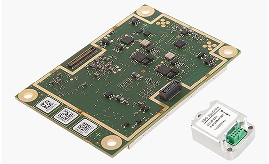
GNSS receiver manufacturer Septentrio has added the AsteRx-i S to its GNSS/INS product portfolio.
The AsteRx-i S combines Septentrio’s compact, multi-frequency multi-constellation GNSS engine with an ultralight external industrial-grade MEMS-based inertial measurement unit (IMU).
Designed around demanding requirements for size, weight, power consumption and temperature variation, the AsteRx-i S is designed for various applications such as inspections with UAVs, UAS photogrammetry, automation, robotics and logistics.
Calibrated for wide temperature ranges, the AsteRx-i S delivers accurate and reliable GNSS/IMU integrated positioning to the centimeter-level, as well as full attitude at high update rates and low latency, the company said.
Key benefits for users include:
GNSS/INS positioning with 3D attitude: heading pitch and roll
AIM+ interference monitoring and mitigation system
High-update rate, low-latency positioning and attitude
Small and ultralight IMU (10 grams)
Robust calibration for wide temperature ranges
“We are delighted to broaden our AsteRx-i GNSS/INS solutions range, bringing maximum flexibility and choice to our customers,” said Francesca Clemente, product manager at Septentrio. “Whether for direct georeferencing in mapping applications with UAVs, for managing containers in a port or for innovative small robots in agriculture, the compactness, affordability and robustness of the AsteRx-i range allows our customers to focus on their success.”
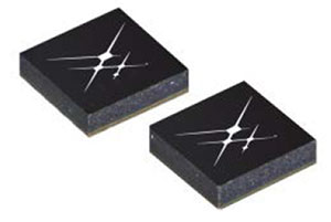
Skyworks has unveiled two new GNSS low-noise amplifier (LNA) front-end modules. The SKY65933-11 and SKY65943-11 both integrate Skyworks’ proprietary TC-SAW filters.
The modules are designed specifically for internet of things (IoT) applications including smartwatches, action cameras, drones, asset trackers and personal navigation devices. athey are designed for wireless module and IoT device manufacturers, providing a turnkey GNSS connectivity solution in a compact form factor.
Both solutions offer:
integrated pre- and post-filter, LNA and matching to reduce PCB area versus a discrete implementation
single DC supply for design flexibility and simplicity
multi-GNSS compatibility to cover GPS, GLONASS, GALILEO, COMPASS (BeiDou) and QZSS receiver applications in the 1559-1606 MHz frequency range
extremely low leakage current (1 uA max) benefitting battery-powered IoT devices
highly manufacturable and low-cost surface-mount technology (SMT) in a 2.5 x 2.5 mm multi-chip module (MCM) package.
SKY65933-11:
Fully integrates all functional blocks, no external components required
Supply range: 1.5 to 2.85 V
Package: 16L 2.5 x 2.5 mm
SKY65943-11:
Exceptional out-of-band rejection and P1dB compression point
DigitalGlobe has released pre- and post-event satellite imagery of the areas in India affected by heavy flooding.
According to the company, massive flooding devastated the Kerala state of India in late May and early August. At least 164 people were killed and more than 223,000 were displayed from their homes and are living in relief camps. In addition, Kerala has seen 40 percent more rainfall than normal since June, which has triggered landscapes in several districts.
In an effort to support disaster response and as a part of its Open Data Program, DigitalGlobe decided to publicly release the satellite images. According to the company, its Open Data Program supports the humanitarian community by providing critical and actionable information to assist response efforts.
The 2018 International Navigation Conference (INC), which will take place Nov. 12-15 at the Mercure Bristol Grand Hotel in Bristol, United Kingdom, will focus on navigation challenges and societal benefits.
According to event organizers, the keynote speakers at the event will focus on developments in resilient positioning, navigation and timing (PNT) innovations; PNT for connected autonomy; human factors and cognition in navigation; mapping and imaging; and progress in quantum technology.
In addition, sessions and themes at INC 2018 will address key navigation topics topics from technical, regulatory, ethical, cognitive and human perspectives.
A link to the live event will be sent to you two hours before the event. Your personalized event URL will be automatically generated by the ON24 system. To ensure receipt of the email, please whitelist this email address by adding it to your contacts: [email protected].
This presentation will begin on at 1 p.m. EDT / 10 a.m. PST on Thursday, September 6, 2018.
Audience members may arrive 15 minutes prior to live time. If you have any questions, please contact event producer Danielle Presta at [email protected].
Gladiator Technologies has introduced a three-axis, inertial rate system gyroscope. The G300D gyro is 0.67 cubic inches, low power and high speed, making it suitable for image stabilization applications, the company said.
The G300D has message timing under 150 microseconds and output data rates up to 8 kHz with external sync. A micro-electro-mechanical gyroscope, it has an ARW of <0.0028 degrees/sec/√Hz and an option for both 24 and 32-Bit LSB for exceptional resolution.
Users can configure the G300D to their desired configuration using a software development kit or through software protocols to simplify the integration process.
“The G300D, with a 250-Hz bandwidth, allows user to replace more complicated and expensive gyros for image stabilization applications,” said Rand Hulsing, chief scientist at Gladiator Technologies. “The three-axis package is also convenient for mounting in any orientation for tight space requirements.”
“The G300D product is a good example of our SX-series architecture, which has enabled Gladiator to extend our sensor fusion technologies into high speed applications with message latency under 150 usec,” said Lee Dunbar, chief software architect at Gladiator Technologies. “This output offers minimal phase lag like an analog sensor by virtually eliminating typical signal processing and digital conversion overheads.”
Remote GeoSystems Inc., a global provider of geospatial video recorder hardware and GIS integration software and solutions, has become an official Silver Partner in the Esri Partner Network after successfully building its business as an Emerging Business Partner in the Esri Startup Program.
Esri offers a Startup Program enabling the most promising emerging businesses to incorporate these innovations into their services and solutions.
Now in its third year, the Esri Startup Program provides the ArcGIS software, online services, support, community involvement and training to kick-start product development or enrich existing solutions.
Remote GeoSystems was one of the first early-stage startups accepted into the program.
“As a small technology company bootstrapping the development and innovative product sales efforts, access to Esri’s flagship ArcGIS platform and team support was invaluable,” said Jeff Dahlke, managing director of Remote GeoSystems.
The LineVision Desktop. (Image: Remote Geosystems)
In its three years in the program, Remote GeoSystems was able to successfully develop and go to market with an array of geospatial video solutions. The company’s LineVision Esri ArcMap Add-in and stand-alone LineVision Desktop with Esri Mapping commercial software tools provide georeferenced video playback, analysis, collaboration and reporting using the Esri ArcGIS platform.
In addition, the new Video GeoTagger and Video GeoEditor (coming soon) products, also built with Esri mapping technology, will be available for use on the ArcGIS Marketplace.
These professional geospatial video and integrated GIS Full Motion Video (FMV) software tools are suitable for airborne, drone and mobile mapping surveys, critical infrastructure inspection and public safety applications.
“The Remote Geo team is building some very feature-rich and capable Esri-based solutions and Add-ins while also bringing a valuable mix of GIS, GPS, deep location-based video expertise and multi-industry experience,” said Francis Kelly, Esri Global Partner Programs manager. “We are excited to work with Remote Geo as their business matures and they continue to contribute to the Esri user community as part of the Esri Partner Network.”
“As a company that was once a startup, we understand the early years for any business are hard,” said Katie Decker, Esri Startup Team community manager. “We are impressed with how the Remote Geo team executed on the opportunities provided by the program, bringing the value of geospatial video to a broader audience using the Esri platform. Their experience is what we envisioned when we implemented the program and we look forward to continuing to work with them.”
Remote GeoSystems LineVision Esri-based solutions key features often include:
Play videos from single and multi-camera video data collection platforms
“Click-on-Map” video navigation
Set a custom geo-fence around the moving position marker
Load shapefiles, imagery and ArcGIS Online datasets
Save geotagged video and photo data as geoProjects for simple project reporting, archive and search
Support for DJI Drone Video data.
All Remote GeoSystems Esri-based solutions are and/or will soon be available in the ArcGIS Marketplace.
The startup PlanetWatchers has developed Foresights, a risk management and geospatial analytics platform designed specifically to help clients manage forestry assets quickly, effectively and accurately.
Foresights identifies areas of new or potential risk, and delivers operations tracking and forest damage management services. The company plans to add satellite-driven analytics, inventory data and forest productivity services to the platform. before the end of the year.
The Foresights platform covers larger geographic areas and delivers results faster and more accurately than traditional project-based companies, traditional inventory methods and off-the-shelf processing tools, the company said.
PlanetWatchers combines multi-source satellite imagery data, topography maps, soil maps, meteorological data and near real-time ground input from operational teams to deliver optimized insights. The tool is capable of detecting disturbances as small as 0.1 ha (0.25 ac) related to pest, disease and drought damage.
Foresights will help forest managers “easily access crucial business intelligence and detailed insights and analytics on a regular basis so they can make proactive and informed decisions and take immediate remedial action,” said Ariel Smoliar, PlanetWatchers’ CEO and co-founder. “Without these higher levels of data and improved frequency of information, they could see negative impacts on their forestry management decisions, their supply chains and, ultimately, their profits.”
Reports identifying locations that require immediate mitigation can be viewed in existing GIS systems and are geolocated for forestry field teams, including offline capabilities for teams operating in remote areas without cellular reception.
“Foresights also fills a data gap known as the ‘Last Mile of Analytics’,” Smoliar said. “When we deliver satellite images to our clients, they shouldn’t have to then analyze and extract information. We remove this pain point for them by providing deep analysis of optical and radar satellite images, and compiling actionable insights and reports, including detailed maps of locations of interest. Our clients are shown not only the location of the disturbance, but also the issue and its cause, granting them vital intelligence they can act on with very little lag time. Foresters will no longer need to process or analyze imagery: this is the game-changing value of the Last Mile of Analytics.”
The Forest Operations service provides foresters with insights to track progress of various forest harvest operations such as thinning and clearcutting. This information assists operations managers in optimizing their wood supply chain and efficiently and effectively managing resources.
The Forest Disturbance service delivers location-specific reports to forest owners and managers detailing areas with identifiable disturbances that could degrade the quality, yield, and profitability of forests. Some disturbances that Foresights can identify to help commercial foresters respond proactively include growth and uniformity issues over time, illegal logging, insect infestations and disease, competitive vegetation, storm damage, drought, wildfires and more.