Geotab has released an interactive infographic depicting the evolution of America’s iconic Interstate Highway System.
The interactive timeline allows users to watch the network expand over the years, providing a detailed look at the development of the infrastructure that has supported transportation and trade across the America for several decades.
Today, the Interstate Highway System accounts for 25 percent of all highway traffic in the United States. As the system nears a major milestone, with the total network approaching 50,000 miles in length, Geotab created the interactive infographic to highlight the development of the highway system in the U.S. throughout the years.
Since its inception in 1956, the Interstate Highway System has been regarded as the backbone of U.S. commerce and infrastructure, playing a vital role in America’s economic growth. The map highlights major developments over the last 60 years, such as the 1974 completion of the I-5 that now connects Mexico and Canada with a singular route and the opening of the I-80, the country’s first coast-to-coast highway.
Geotab’s “Evolution of the Interstate” infographic provides the public with the ability to watch the Interstate Highway System expand over the years, enabling them to engage with particular dates and sections of the extensive network. The interactive map also includes relevant details about the city each highway serves, the length of that specific highway, and provides the total mileage covered by the entire network in any given year.
“As America’s Interstate Highway System approaches a major milestone, we wanted to pay tribute to this intricate and expansive network,” said Maria Sotra, vice president of marketing at Geotab. “Connecting people, enabling business and providing a straightforward path across one of the largest countries in the world, the nearly 50,000 miles of highway that makes up the Interstate Highway System has played an undeniable role in transportation and trade in the United States.”
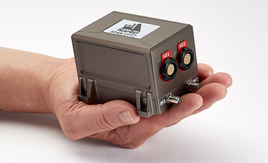
NovAtel is now delivering its SPAN tightly coupled GNSS+INS navigation technology in a rugged, ultra-compact unit.
Commercially exportable and designed for integration into a wide variety of applications, the high-performance SPAN CPT7 delivers assured positioning anywhere, in a package one-quarter the size of the company’s SPAN-CPT.
SPAN technology leverages generations of precise positioning expertise and advanced algorithms to tightly couple GNSS and inertial navigation system (INS) measurements. The system enables continuous, robust positioning and fast reacquisition in challenging navigation environments where GNSS signals may be unreliable or unavailable for short periods.
The new SPAN CPT7 also incorporates dual antennas to deliver instant alignment, along with interference detection and mitigation using NovAtel’s OEM7 Interference Toolkit (ITK) technology.
Integrators can take advantage of a spectrum analysis function of ITK to identify interference within the GNSS frequency bands and whether interference is coming from the external environment or due to other components in an integration project, NovAtel said. Mitigation features within ITK allow developers to implement digital filters and eliminate the problem.
Combining the multi-frequency, multi-constellation technology of the OEM7720 receiver board with ITK and the high-performing micro-electromechanical systems (MEMS) IMU, the SPAN CPT7 delivers anti-jamming functionality in an ultra-compact enclosure that fits in the palm of your hand. When paired with the GPS Anti-Jam Antenna (GAJT) in military applications, SPAN CPT7 is an integral part of assured position, navigation and timing (A-PNT).
“The remarkable new SPAN CPT7 delivers solutions for defense, mobile mapping, and autonomous vehicle applications with more flexibility than ever before,” said Neil Gerein, director, product management, NovAtel. “This new product saves customers space and weight without compromising accuracy or performance.”
Most image analysis tasks that required ENVI or Erdas Imagine software are now available online with EOS Platform, a new cloud service launched by Earth Observing System (EOS). It provides GIS professionals with a one-stop solution for search, analysis, storing and visualization of large amounts of geospatial data.
EOS Platform is an ecosystem of four mutually integrated EOS products, which together provide a powerful toolset for geospatial analysts, according to the company. Image data obtained from LandViewer or uploaded from a user’s computer is stored in cloud-based EOS Storage and is instantly available for remote sensing analysis or image processing.
EOS Processing offers 16 processing workflows that run online, including raster tools (merge, reprojection, pansharpening), remote sensing analytics, photogrammetry and proprietary feature extraction algorithms designed by EOS engineers and data scientists to address the main challenges of agriculture, forestry, oil, gas, retail, city planning, defense and other industries. Such pre-processing tasks as cloud detection or radiometric calibration refine raw data for further analysis. Images can be corrected for atmospheric effects to obtain the real ground radiance or reflectance values.
Users can also use the cartographic features of EOS Vision for vector data visualization and analysis (analysis coming soon). Other features in upcoming updates include lidar analysis and 3D modeling.
Data agnostic platform
Users can work with a variety of satellite and airborne raster datasets in EOS Processing, EOS Storage and LandViewer, which enables quick and intuitive search of images within collections of Sentinel-1 and 2, Landsat 8 and 7, MODIS, NAIP, CBERS-4, Landsat 4 and 5. Besides downloading images from public datasets, users can also upload their own GeoTiff, JPEG, JPEG 2000 files and apply GIS data-processing algorithms via API or from the web interface. EOS Vision is a tool for vector data operations with multiple format support (ESRI Shapefile, GeoJSON, KML, KMZ).
Object detection, change detection and classification
The convolutional neural networks, pre-trained by EOS to extract features from imagery, allow users to apply state-of-art methods to detect objects and track changes from space.
Having only a set of multi-temporal images and change detection workflow, users can track how illegal deforestation progresses over time.
Edge detection can show the exact boundaries of agricultural lands down to the last pixel.
It is possible to estimate the parking lot traffic of the largest shopping centers with a car detection algorithm.
Products within EOS Platform support almost all remote sensor types. Users can choose from numerous spectral indices to calculate on the fly.
Aside from the complete set of vegetation indices (Normalized Difference Vegetation Index, NDVI; Red-Edge Chlorophyll Index, ReCI; etc.), there are also indices to outline landscape features (Normalized Difference Water Index, NDWI; Normalized Difference Snow Index, NDSI) and burned areas (Normalized Burn Ratio, NBR).
One of the most useful features is the ability to experiment with spectral bands: users can create custom band combinations and indexes on top of the default ones.
The user-friendly interface of EOS Processing makes it easy to manage processing workflows depending on the user’s business needs. Users can set the parameters for processing and repeatedly use customized workflows to automate high-frequency analytical tasks. Coming updates will add an ability to create custom algorithms from the available data-processing operations.
Agriculture, forestry, oil and gas and more industries
A tandem of EOS products form a comprehensive toolbox both for general use and for industry-specific cases, the company said. With vegetation indices and crop classification feature, agronomists can continuously monitor crop conditions to detect plant diseases, pests and droughts. Forestry specialists can classify forest types, assess fire damage, monitor forest health, and track and enforce logging restrictions.
EOS Platform can also be used for regional and urban planning. It helps users identify land cover classes to generate a vegetation map and can also make a complete list of urban features such as buildings, roads or other major features in the region.
The platform can tackle disaster management by measuring flood extent and finding fire boundaries. When it comes to oil and gas, it is capable of identifying oil rigs and assessing the environmental impact.
I’m impressed, as always, by the engagement of our webinar audience. Questions are pouring in about the speakers’ presentations, in addition to knowledgable queries submitted before the webinar began. These events strike me as, hour for hour, the best professional education one can get, short of leaving the office for a week to attend ION GNSS+ or the institute’s other conferences through the year, or the European Navigation Conference or Intergeo or others of the like. And a webinar takes only an hour of your time! From the comfort of your desk! Or sofa, even.
Here are some of the questions posed, and brief digests of our experts’ answers. The panel included John Fischer, VP Advanced R&D at Orolia, assisted by Jon Sinden, product manager for Rugged PNT; Tim Erbes, CTO at Talen-X; and Carol Politi, CEO at TRX Systems.
Q: Role of Galileo Public Regulated Service (PRS) in GPS-disrupted environment? Particularly given NATO alliance and cooperation? Any more detail about use of other GNSS to make solution more robust?
A: The PRS is certainly low-hanging fruit for traditional partners to take advantage of both GPS and Galileo, and I imagine fielded solutions will soon start to show that. There are substantial benefits to be gained from use of other GNSS as well.
Q: Please discuss the hardened military aspects of coming GPS III signals and codes. How will the new GPS III constellation impact your products?
A: Block III alone is not enough to make this happen. A new M-code will eventually replace the SAASM M-code, and it will provide a true separation from the civilian signal, different from the current situation with M-code and C/A code. Already, a dozen or more IIF satellites are now transmitting it. But the upgrade has to happen in three places for it to become effective: the satellites, the user receiver — and this is a complex, extremely broad and varied picture in the military realm — and finally the ground control system. There have been some difficulties in deploying the new OCX. This is the biggest determining factor of when these new features will roll out.
Q: What is the potential role of other means of PNT: eLoran, Iridium STL, lidar, and so on?
A: ELoran a very good alternative, ideal from the point of view of diversity: terrestrial instead of satellite, high-power instead of low, other end of spectrum from GNSS. Orolia published a white paper on a holistic approach towards resilient PNT, discussing eLoran and STL; see our website.
There are additional opportunities for outside-the-box solutions, for example, the sensors aboard tanks for anti-missile defense systems. They could also be used for PNT. Networked data radios for crowdsourced PNT data.
An upcoming episode of “Advancements” with Ted Danson will explore recent developments in autonomous vehicles such as drones, cars, trucks, excavators and other heavy machinery.
The episode is scheduled to broadcast in the fourth quarter of this year.
Image: Advancements
The segment will focus on Septentrio’s secure GNSS technology for unmanned systems. Septentrio is a designer and manufacturer of GNSS receivers and surveying equipment, delivering accurate and precise GNSS positioning scalable to centimeter-level even in challenging environments.
Advancements will educate viewers about Septentrio’s GNSS technology, which provides both the accuracy and robustness required, while integrating and synchronizing seamlessly with navigation systems and payloads.
“In a few years, autonomous cars will be driving us around, with greater safety, efficiency and comfort than ever before,” said Jan Van Hees, director of marketing and business development, Septentrio. “All of these vehicles depend critically on a multitude of sensors to determine where they are, with robust GNSS sensors at the heart of the system. It is critically important that the GNSS technology used supplies not just highly accurate data, but also a high level of reliability. That’s where the technology from Septentrio comes in.”
Autonomous trucks and agricultural machines are already being used to make worker activities safer and more efficient. Drones can go to places that would otherwise be too expensive or dangerous for human workers to reach.
Farmers use unmanned systems to survey and even spray crops; NGOs employ them to launch search and rescue operations in disaster zones; event coordinators monitor crowds with them at major musical festivals, and conservationists can track and protect endangered species better in risky areas with them.
“For many years now, driven by our customers, we have been developing GNSS technology for industrial applications that is not only very accurate, but also reliable in the harshest of environments,” Van Hees said. “With the advent of drones and the interest in developing autonomous cars and trucks, this focus on secure GNSS is becoming ever more important. It’s exciting to see this technology affecting our daily lives more and more.”
“UAVs and other autonomous systems have an enormous potential in aerial surveying, inspection, and a host of other industries,” said Rochelle Hyman, senior producer for the Advancements series. “The autonomous industry is important to Septentrio, and we look forward to sharing the innovative technologies that have been designed and developed by the company.”
The Advancements series is an information-based educational show, targeting recent advances across a number of industries and economies. Featuring state-of-the-art solutions and important issues facing today’s consumers and business professionals, Advancements focuses on cutting-edge developments, and brings this information to the public with the vision to enlighten about how technology and innovation continue to transform our world.
Commercial drone operators in California and Hawaii — as well as a few areas in Nevada, Utah and Arizona — now can get quickly authorized to fly in controlled airspace, Skyward announced.
Screenshot: Skyward
Skyward is an FAA-approved airspace vendor. With Skyward, pilots can access the FAA’s LAANC (Low Altitude Airspace Notification Capability) across the five states.
This means that pilots with a Part 107 license can get permission to fly in regulated airspace in seconds compared to manual authorizations that can take months, making it significantly easier for businesses of all sizes, particularly in the construction and warehousing industries, to manage a fleet of drones to access valuable, cost-saving data.
The LAANC platform lets UAV operators take advantage of this digital timesaver. Skyward was the first provider approved by the FAA to offer LAANC, and Skyward saw quick adoption by its customers as soon as the prototype was released on Oct. 23, 2017.
This phase of Skyward’s LAANC expansion includes airspace in some of the country’s busiest metro areas, including Los Angeles, the Bay Area, San Diego, Las Vegas and more than 50 smaller air markets. It will help the full diversity of businesses in the west find new ways to use drones in their operations through LAANC capability.
(From left) Francois Lombard and Dirk Hoke, Airbus, sign agreement with Will Marshall, Planet.
Airbus and Planet have entered into a partnership to facilitate access to each other’s data and the co-development of new geospatial solutions.
The companies are establishing a framework agreement to explore opportunities for joint cooperation in new and existing markets, product offerings, sales and marketing efforts.
Both companies aim to provide a comprehensive suite of global satellite data at multiple temporal and spatial resolutions, and develop new analytic products for a wide range of applications to benefit their customers.
Benefitting from both companies’ constellations, customers will have access to the entire Earth’s landmass every day at 3m resolution with PlanetScope satellites, as well as to intra-daily sub-meter resolution imagery with Pléiades and SkySat constellations.
In addition, they will also have the capability to order images with resolutions of 1.5m (SPOT 6/7), 5m (Rapideye) and 22m (DMC Constellation).
Lastly, TerraSAR-X, TanDEM-X and PAZ radar satellites will allow the acquisition of images regardless of weather and daylight conditions, ensuring access to any place on Earth independent of cloud coverage.
“By combining our strengths, we will provide a key capability to address all market needs, both in terms of data and value-added products, and to best serve our clients, whatever their industry and their requirements,” said François Lombard, director of the Intelligence Business at Airbus Defence and Space.
“Airbus and Planet are truly complementary partners. Airbus brings long-standing success in serving reliable, high resolution remote sensing, and Planet brings its unique global coverage and temporal cadence, as well as agile aerospace iteration to get sensors quickly to space,” said Will Marshall, CEO and co-founder of Planet. “Together we will be able to deliver sophisticated offerings to fit customer needs across international markets.”
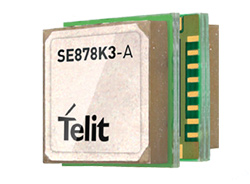
Telit, a global enable of the internet of things (IoT), has debuted its SE878Kx-A series of GPS and GNSS integrated antenna receiver modules for consumer and business applications. According to the company, these modules provide high performance, maximum reliability and low power consumption.
In addition, the SE878K3-A and SE878K7-A are compatible with GPS, GLONASS, Beidou and Galileo and also enable device vendors to develop quickly and cost-effectively location-based IoT solutions for use in virtually any country worldwide, Telit said.
The SE878Kx-A series supports dual internal-external antennas to ensure connectivity when one is broken or compromised, along with a SAW filter to maximize jamming immunity. According to Telit, these features make the modules ideal for mission-critical applications and other use cases where reliability is key, such as alarms, stolen cars or high-end asset tracking.
The SE878Kx-A series also provides seamless integration with Telit’s cellular modules, including eCall/ERA-GLONASS compliant solutions.
“The new SE878Kx-A series is the latest example of Telit’s leadership in providing GNSS solutions for applications that demand the highest reliability and performance,” said Yossi Moscovitz, Telit president of products and solutions. “Just as important, the modules give IoT designers maximum flexibility, faster development cycles, easier integration and the ability to develop once and deploy worldwide.”
Hexagon AB has launched the Leica RTC360, a laser scanner equipped with edge computing technology to enable fast and accurate creation of 3D models in the field. The Leica RTC360 is one of many innovations showcased at HxGN Live 2018, the company’s annual digital technology conference.
According to Hexagon, the Leica RTC360 combines high-performance laser scanning, edge computing and mobile app technologies to pre-register captured scans quickly and accurately. With the push of a button, two million points per second of high dynamic range imagery can be captured to create a full-dome scan in under two minutes, Hexagon added.
In addition, the laser scanner features a visual inertial system that automatically tracks movements between setup positions. The scans captured by the Leica RTC360 can be combined and pre-registered on a mobile device, where they can be viewed and augmented with information tags.
“We designed the Leica RTC360 for maximum productivity. For construction professionals, plant operators, public safety officials and other professionals who face complex projects with tight constraints, it provides a better way to digitally capture the reality of their sites — and process and visualize that data for faster, immediate decision making,” said Ola Rollén, Hexagon president and CEO. “What these professionals do on site every day is challenging, and we aim to continue to make their work quicker, easier and more accurate.”
Hexagon AB provides digital solutions that create autonomous connected ecosystems, a state where data is connected seamlessly through the convergence of the physical world with the digital, and intelligence is built-in to all processes.
MicroPilot received a $2 million contribution toward its $5 million project to develop systems and processes that will allow certification to DO-178C airworthiness standards. In other words, MicroPilot aims to demonstrate a level of software reliability that will allow regulators to permit UAVs to operate over cities and towns.
MicroPilot is leading the Hi-Rise research consortium, a group of companies from different nations that is working to help achieve this goal.
“This is such a large project because the software and certification process for DO-178C compliance is complex and difficult,” said Howard Loewen, president of MicroPilot. “MicroPilot and the Hi-Rise consortium are always looking for new and innovative ways to assure regulators that the software is reliable.”
According to MicroPilot, it will use this contribution to further its goals to improve the regulatory and software certification framework for UAVs.
A U.S. soldier preparing his Blue Force Tracker before departing Camp Victory, Iraq in 2005. (Photo: Petty Officer 1st Class Brien Aho, U.S. Navy)
A free GPS World webinar, sponsored by Orolia and taking place at 1 p.m. EDT on Thursday, June 21, will discuss “Defense PNT in Challenged Environments.”
The webinar will consider the reliance on GPS in modern land-warfare systems, as well as the potential effects of GPS disruption on their operations and ways to protect their ability to continue operating in a GPS-disrupted environment.
John Fischer, vice president of advanced R&D at Orolia; John Sinden, product manager for rugged PNT at Orolia; and Tim Erbes, CTO at Talen-X, will present during the webinar. GPS World Editor-in-Chief Alan Cameron will moderate it.
Fischer, who has worked with global navigation satellite systems, wireless, positioning navigation and timing at Orolia for more than 15 years, will highlight protecting GPS-reliant military systems during his presentation. Fischer will also discuss considerations for protecting land-warfare systems’ ability to continue operating in a GPS-disrupted environment from jamming, spoofing or environmental interference.
According to IAIN, all submitted abstracts will be reviewed by the Science Program Committee.
The abstracts must be submitted online, and authors can submit more than one abstract. The abstracts may be submitted as an oral or poster presentation and must be written in English, IAIN adds. Selected abstracts will be published in the program book.
IAIN World Congress 2018 will be hosted by the Japan Institute of Navigation and will focus on science, technology and practice in regard to resilient navigation.
IAIN is a non-governmental, non-profit organization that works to unite national and multinational institutes and organizations that aim to foster human activities at sea, in the air, in space and on land.