Category: Uncategorized

  • Northrop Grumman partners with San Diego Zoo for polar bear conservation project

    Northrop Grumman partners with San Diego Zoo for polar bear conservation project

    In late 2017, Northrop Grumman and San Diego Zoo Global planned and carried out a research mission to map Arctic sea ice formations to learn more about polar bear habitats — proving autonomous technology is making a name for itself as a key tool in conservation projects.

    The project began as a competition between teams of Northrop Grumman employees who aimed to find a way to map Artic sea ice formations, and the winning team — Team Polar Eye from Melbourne, Florida — earned the privilege of using its technology to map the area.

    “The project name is Wildlife Challenge,” said Charlie Welch, materials and process engineer at Northrop Grumman and technical lead of the Wildlife Challenge. “It’s a collaboration between San Diego Zoo Global and Northrop Grumman to help bring really high-level technology to the San Diego Zoo’s conservation efforts — specifically unmanned technology.”


    Polar bears have to wait for the ice to freeze to hunt, and the zoo wanted to repeatedly map the same area in the Artic to learn more about the ice, including how it’s freezing, where a polar bear is on the ice and what the ice looks like, such as its thickness. The zoo then planned to use this data to predict how changes in the ice — and overall climate change — will affect the polar bears.

    To carry out the project, the Northrop Grumman team developed a drone that could handle the freezing temperatures. The team then flew to Northern Canada to gather the ice data.

    “We had to take the drone out to the middle of nowhere, basically, and be confident that this could work and collect critical data on a really key, iconic species,” Welch said. “Half the engineering was designing the logistics of getting our team out there, getting every spare part we could think of and making sure that we could survive out there, along with the system.”


    Click on the icon in the top left hand corner to choose the video you’d like to watch.


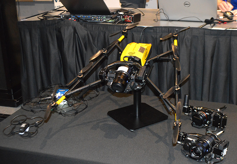
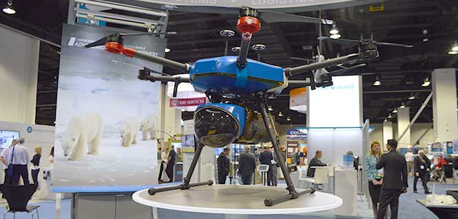
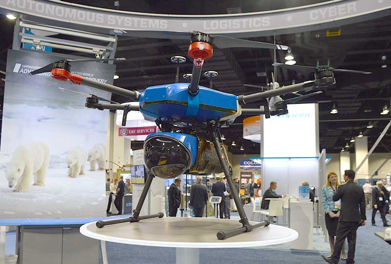
    During the 10-day mission, the team used its modified DJI M600 hexacopter drone to capture the data, as well as ground equipment to process the data and ensure the drone was operating correctly. According to the company, the hexacopter platform consisted of six rotors, a triple-redundant navigation system, high-voltage battery packs and a custom payload bay to hold a range of integrated sensors. It was also equipped with a ruggedized thermal shell, designed to withstand temperatures as low as minus-20 degrees Fahrenheit.

    “We had to make a few adjustments in the field, as we kind of anticipated,” Welch said. “So we designed the drone to be reconfigurable really easily.”

    The Northrop Grumman team used its modified DJI M600 hexacopter drone to capture the ice data. Photo by Allison Barwacz

    The team conducted several successful sea ice mapping missions and collected an array of habitat data, including 3D sea ice maps and multispectral data, both collected at sub-centimeter resolution, the company said. Northrop Grumman sent the data to zoo scientists, who are still closely working with the company. Northrop Grumman also donated its hexacopter drone to the zoo so that it be used for other conservation projects.

    “We’re keeping in collaboration [with the zoo] to try and figure out what they want to do next from a scientific perspective, and how the data we collected is working out for what their goals were,” Welch said. “We see these innovative projects as a good way to engage our employees and give them the ability to work on projects that are very science-based. We also want to make a positive impact toward STEM (science, technology, engineering and mathematics) and be able to show students how engineering and science fields can be applied in a variety of ways.”

  • 2018 Inertial Buyers Guide

    2018 Inertial Buyers Guide

    VectorNav Technologies

    VectorNav designs and manufactures three different product types:

    • Inertial measurement unit / altitude heading reference System (IMU/AHRS)
    • GPS-aided inertial navigation system (GPS/INS)
    • GPS/INS with built-in GPS-compass (dual GNSS/INS).

    Each product type is offered in two performance categories, Industrial and Tactical Grade, which is an indication of the quality of the IMU core.

    Product Models

    VectorNav product models

    Key Product Features

    The VectorNav VN-300

    Industrial Series:

    • High-performance in SWaP-C optimized packaging
    • 5˚/hr typical in-run gyro bias stability
    • 0.3˚ RMS heading, 0.1˚ pitch & roll
    • Miniaturized surface mount (OEM) and rugged packaging
    • Serial TTL, SPI and USB communication interfaces
    • < 30 grams

    Tactical Series:

    • The VectorNav VN-310.

      Tactical-grade performance in ruggedized enclosures

    • < 1˚/hr in-run gyro bias stability
    • < 2 mrad attitude performance
    • IP68-rated enclosure designed to meet DO-160G
    • Support for external GPS/GNSS or IMUs
    • < 200 grams

    All VectorNav products:

    • incorporate VectorNav’s robust inertial navigation algorithms
    • are individually calibrated across full temperature range (–40 C to +85 C)
    • share a common communication protocol across all products
    • offer sync-in and sync-out functionality and GPS PPS
    • ship worldwide on short lead times (1–2 business days)
    • are supported directly by VectorNav’s team of applications engineers, business and production teams, and domestic and international representatives
    • are produced at VectorNav’s AS9100 certified facility
    • are made in the U.S. and ITAR-free.

    www.vectornav.com
    [email protected]
    10501 Markison Road
    Dallas, TX 75218 USA


    NovAtel

    PwrPak7D-E1

    The PwrPak7D-E1.

    The PwrPak7D-E1 is a robust, high-precision receiver that has multi-frequency, dual-antenna inputs and provides GNSS multi-constellation heading and position data. These capabilities make the PwrPak7D-E1 suitable for ground vehicle, marine or aircraft-based systems. NovAtel’s Synchronous Position, Attitude and Navigation (SPAN) technology brings together GNSS positioning and inertial navigation to provide an exceptional 3D navigation solution that is stable and continuously available. The PwrPak7D-E1 has a powerful OEM7 GNSS engine, integrated Epson G320N micro electromechanical (MEMS) inertial measurement unit (IMU), built-in Wi-Fi and 16 GB of internal storage.

    Key Product Features

    • SPAN-enabled enclosure featuring NovAtel’s tightly coupled GNSS+INS engine
    • Enhanced connection options including serial, USB, CAN and Ethernet
    • 555-channel, all-constellation, multi-frequency positioning solution
    • Multi-channel L-band supports TerraStar correction services
    • Onboard NTRIP client and server support
    • Multiple communication interfaces for easy integration and installation
    • Built-in Wi-Fi support
    • 16 GB of internal storage
    • ALIGN heading solution

    Signal Tracking

    Primary RF

    • GPS (L1 C/A, L1C, L2C, L2P, L5)
    • GLONASS (L1 C/A, L2 C/A, L2P, L3, L5)
    • BeiDou (B1, B2)
    • Galileo (E1, E5 AltBOC, E5a, E5b)
    • NavIC/IRNSS (L5)
    • SBAS (L1, L5)
    • QZSS (L1 C/A, L1C, L2C, L5)
    • L-Band (up to 5 channels)

    Secondary RF

    • GPS (L1 C/A, L1C, L2C, L2P, L5)
    • GLONASS (L1 C/A, L2 C/A, L2P, L3, L5
    • BeiDou (B1, B2)
    • Galileo (E1, E5 AltBOC, E5a, E5b)
    • NavIC/IRNSS (L5)
    • QZSS (L1 C/A, L1C, L2C, L5)

    www.novatel.com
    [email protected]

  • Live from AUVSI’s Xponential 2018

    Live from AUVSI’s Xponential 2018

    The GPS World and Geospatial Solutions staff reported live from the Association for Unmanned Vehicle Systems International’s (AUVSI’s) Xponential 2018 April 30-May 3 in Denver.

    The event convenes the global community of commercial and defense leaders in intelligent robotics, drones and unmanned systems. Check out news, photos and videos from the show.

    NEWS

    News announced at the show
    Pre-show articles

    VIDEOS

    Click on the icon in the top left hand corner to choose the video you’d like to watch.

  • Intel shares updates on Insight Platform, drone solutions at Xponential 2018

    Intel shares updates on Insight Platform, drone solutions at Xponential 2018

    Intel’s Anil Naduri discussed some of the company’s updates at Xponential 2018. Photos by Allison Barwacz

    Intel shared a number of updates at a presentation during AUVSI’s Xponential 2018, which took place April 30-May 3 in Denver. Among the company’s latest developments are its Insight Platform, Mission Control and Falcon 8+.

    Intel Insight Platform

    Intel’s Insight Platform is a digital asset management system that enables aerial data management and analysis. It allows customers to store, share and manage data that commercial drone systems collect. According to the company, the platform is designed to reduce costs, improve efficiency and fuel growth.

    The Intel Insight platform takes the aerial data and can generate 2D and 3D models, take measurements and run data analytics.

    “The asset-based approach allows you to tag repeated flights over the same location, and that provides a great foundation for you,” said Anil Nanduri, vice president and general manager of the Intel drone team.

    Intel Mission Control

    Intel’s Mission Control is the company’s next-generation flight planning software for its Falcon 8+ drone. According to the company, it is designed to increase workflow efficiency and enhance automation of drone flights for commercial missions.

    Mission Control allows Falcon 8+ drone operators to create 2D and 3D flight plans for commercial surveying, mapping and inspection missions.

    Intel Mission Control software is currently in beta testing with customers, Intel said.

    Falcon 8+ drone

    Photo by Allison Barwacz
    Intel revealed three new payloads for its Falcon 8+ at Xponential. Photo by Ryan Gerard

    During the presentation, Intel revealed three new payloads, as well as distance hold and distance guard features, for its Falcon 8+ drone.

    The three new payloads are designed for inspection, surveying and mapping applications. According to Intel, the Falcon 8+ also now boasts distance hold and distance guard features on the Intel Imaging and Duel Imaging payloads. The distance hold feature allows the drone to maintain and hold a set distance from certain obstacles during inspections, and distance guard is another obstacle avoidance feature.

    The company also shared how the drone has assisted with natural disasters and safety inspections. The Falcon 8+ played a role in disaster relief for the Sonoma County fires, as well as data recovery following Hurricane Harvey in Houston.

    The drone also assisted with a gas terminal inspection in Scotland, as well as with Arctic wildlife research.

    “Drones are going to be the most transformative business technology in the coming generation,” Nanduri said.

  • Raytheon to partner on drone-testing airspace corridor

    Raytheon to partner on drone-testing airspace corridor

    The Northeast UAS Airspace Integration Research Alliance selected Raytheon as a key partner in the development of America’s first and most advanced unmanned aircraft system-testing airspace corridor in New York state.

    Raytheon’s Intelligence, Information and Services business will help plan, design, build and support the state’s next-generation air traffic management system to safely test and manage drones.

    “UASs are playing an increasingly important role in our society, which means we must have low-altitude air traffic management solutions,” said Matt Gilligan, vice president of Raytheon’s Navigation, Weather and Services mission area. “The New York airspace corridor is the first-of-its kind, but it won’t be the last.”

    A single-engine plane lands with the aid of a compact, Raytheon-made low-power radar during a flight-check demonstration for the U.S. government. (Photo: Raytheon)

    The new corridor will extend 50 miles (80 kilometers) west from Griffiss International Airport, which is one of only seven Federal Aviation Administration (FAA)-approved unmanned aircraft systems test sites in America.

    The corridor will allow companies to test both drones and air traffic management technologies in real-world settings, generating valuable data that will inform industry and regulators and ultimately advance the commercial use of drones.

    “We have identified the most qualified organizations to complete the New York UTM corridor and expand our UAS testing capabilities,” said Maj. Gen. Marke F. “Hoot” Gibson (ret), NUAIR Alliance’s chief executive officer. “With all our state economic and technical support, I think we are well positioned to accelerate the UAS industry and further establish this region as a national leader.”

    Raytheon’s leadership in air traffic management includes the low-power radar (LPR), a small, one-meter square Active Electronically Scanned Array (AESA) software-defined radar unit. When numerous LPRs are networked together, the radar units can cover and control the low-altitude flights of smaller craft — a feat not possible with current large radar systems.

    A distributed, low-level LPR network could be created with relative ease, mounting the system atop current cell-phone towers or tall buildings.

    A LPR network could support:

    • safe plane and drone landings
    • aviation surveillance
    • precision weather observations (including 3D wind information and urban hydrology)
    • small drone detection and tracking
    • border security and surveillance
    • wildfire detection
    • elevation and geographic gap fills.
  • Humanitarians using life-saving drones honored at AUVSI Xponential

    Humanitarians using life-saving drones honored at AUVSI Xponential

    Five organizations that flew drones on critical, life-saving missions are winners of the inaugural XCELLENCE Humanitarian Award by the Association for Unmanned Vehicles Systems International (AUVSI).

    The award, which is sponsored by DJI, was presented at the AUVSI Xponential 2018 conference at the Colorado Convention Center in Denver.

    “We are thrilled to recognize and reward organizations who have utilized drone technology to make great contributions to their communities and the environment, through AUVSI’s inaugural Humanitarian Awards,” said Michael Perry, managing director of North America at DJI.

    “We congratulate the winners and thank all those who have participated for sharing the innovative ways they use drones to support humanitarian and life-saving efforts around the world,” Perry said. “We hope this award will inspire more organizations and drone operators to accomplish great feats and help others in their community.”

    In Rwanda, fresh blood is launched to a hospital using a Zipline drone. (Image: CNN video)

    These first recipients of the AUVSI XCELLENCE Humanitarian Award were recognized for using drones for disaster management, medical assistance and search-and-rescue operations at locations around the world:

    • Aeryon Labs Inc.: Aeryon SkyRanger UAS provides critical aerial intelligence to first responders in Sint Maarten in the wake of Hurricane Irma (Canada).
    • DroneSAR, DroneSAR UAV Search & Rescue (SAR) Solution: Executing autonomous aerial search and delivering live drone data to augment first response efforts (Ireland).
    • Nepal Flying Labs: drone hazard and vulnerability mapping in Nepal (Nepal).
    • ONG DroneSAR Chile: Emergency response team and humanitarian aid through the use of drones (Chile).
    • Zipline International: Zipline’s medical drone delivery operation in Rwanda (Rwanda).

    “As these organizations have shown, unmanned aircraft systems that are typically flown for commercial purposes are also capable of accomplishing vital humanitarian missions,” said Brian Wynne, president and CEO of AUVSI. “With sophisticated on-board cameras and sensors, drones can quickly fly to remote locations or areas that are inaccessible to ground vehicles because of roads blocked by storm debris or flooding.”

    The five organizations will equally divide a $25,000 donation as prizes for their ground-breaking humanitarian and philanthropic efforts.

  • KVH and VectorNav collaborate to offer precision inertial navigation system

    KVH and VectorNav collaborate to offer precision inertial navigation system

    VectorNav’s Tactical Series line of inertial navigation systems now supports KVH’s high-performance fiber optic gyro-based 1750 IMU and 1775 IMU.

    Inertial sensor companies KVH Industries Inc. and VectorNav Technologies LLC have announced that KVH’s fiber optic gyro (FOG)-based 1750 IMU and 1775 IMU will now be offered to enhance the operation of VectorNav’s VN-210 and VN-310 Tactical Series GNSS-aided inertial navigation systems.

    The products are on display in KVH’s (#2600) and VectorNav’s (#2214) booths at the AUVSI Xponential conference in Denver, Colorado, taking place April 30-May 3.

    The VectorNav Tactical Series products with KVH’s FOG-based inertial measurement units (IMUs) combine the precision and reliability of KVH’s FOG technology with the robust filters and high-performance navigation algorithms of VectorNav’s inertial navigation systems.

    The combined capabilities represent an affordable, effective alternative to larger, higher-cost inertial navigation systems and provide improved accuracy in challenging environments, the companies said.

    Photo: VectorNav/KVH
    Photo: VectorNav/KVH

    VectorNav’s Tactical Series includes an onboard micro-electromechanical systems (MEMS)-based IMU, which provides some advantages for customers who have constraints in terms of size and weight in their navigation and stabilization applications.

    However, in terms of inertial accuracy, the most demanding applications require performance that can only be delivered by FOG-based IMUs, for which KVH is a leading provider.

    The VectorNav Tactical Series products with KVH FOG-based IMUs are designed for such applications as:

    • Satcom On The Move
    • gimbal and camera pointing and stabilization
    • weapons systems targeting and stabilization
    • autonomous vehicle navigation
    • lidar mapping
    • georeferencing

    or any application where MEMS-based solutions are unable to deliver sufficient accuracy and precision.


    Watch this video from Xponential 2018 to learn more about the partnership.


    A single cable connects the two systems, running from KVH’s 1750 IMU or 1775 IMU directly to the auxiliary port on the VN-210 or VN-310. This pairing creates a fully integrated FOG-based inertial navigation system designed to provide a high-accuracy, continuous positioning, velocity, and attitude solution.

    KVH is a leading innovator for assured navigation and autonomous accuracy using high-performance sensors and integrated inertial systems. KVH’s widely fielded TACNAV systems are in use by the U.S. Army and Marine Corps as well as many allied militaries around the world.

    KVH’s FOGs and FOG-based IMUs are in use today in a wide variety of applications ranging from optical, antenna, and sensor stabilization systems to mobile mapping solutions and autonomous platforms and cars.

    “We are pleased to feature KVH technology in our Tactical Series and give our customers the option of utilizing a FOG-based IMU for higher precision performance to support a wide range of demanding applications,” said Jakub Maslikowski, director of sales and marketing for VectorNav.

    “The combination of VectorNav’s Tactical Series products with our FOG-based IMUs provides a great solution for applications that require advanced inertial navigation capability and FOG-level IMU performance,” said Jay Napoli, vice president of FOG/OEM sales for KVH.

  • New Hemisphere GNSS antenna designed for UAVs

    Hemisphere GNSS has released its new multi-GNSS, multi-frequency four-helix HA32 UAV antenna.

    Hemisphere GNSS made the announcement at AUVSI Xponential, being held this week in Denver, Colorado.

    The HA32 is a high-performance antenna that supports GPS, GLONASS, Galileo, BeiDou, Hemisphere’s own Atlas L-band correction service. It was designed specifically for UAVs, GIS, surveying, real-time kinematic (RTK) and other applications requiring high-precision positioning and navigation.

    According to the company, the HA32 is built on an innovative and proprietary four-helix antenna technology that provides superior filtering and anti-jamming performance with low noise amplifier (LNA) features such as a low noise figure of 2.0 dB (typical) and up to 30 dB gain (typical).

    Suitable for most outdoor and harsh operating environments, the HA32 antenna is sealed in a durable and ruggedized IP67-rated enclosure for protection against dust and water and is equipped with an O-ring. The lightweight (40 g, typical) and compact form-factor (40 mm x 75 mm) design of the antenna makes it resistant to wind when installed on UAVs and offers easy integration with a single subminiature version A (SMA) RF connector.

    “We are very excited to be introducing this extremely competitive entry-level UAV GNSS antenna for a wide range of positioning and navigation applications such as UAVs, GIS, and RTK,” said Miles Ware, director of marketing with Hemisphere GNSS. “The features and specifications of this antenna is another example of the innovation and incredible value that Hemisphere is known for.”

    AUVSI Xponential attendees can visit the Hemisphere booth (#4228) to see the HA32 UAV GNSS antenna in person.

  • Swift Navigation presents, exhibits at Xponential 2018

    Swift Navigation is exhibiting and speaking at AUVSI Xponential 2018, being held this week in Denver.

    Swift Navigation is a ​​San ​​Francisco-based ​​technology ​​firm ​​building centimeter-accurate ​​GPS ​​technology ​​to ​​power ​​a ​​autonomous ​​vehicles.

    Xponential 2018, held at the Colorado Convention Center, is the largest and most comprehensive trade show for unmanned systems and robotics. Learn more about the convention and see GPS World’s coverage.

    On Wednesday, May 2, 3:15–3:45 p.m., Swift Navigation’s Product Manager Akshay Bandiwdekar and Sales Executive David Fischer will lead an educational session on “The Role of RTK in the Autonomous System Sensor Suite.” Join them in Room 203, where they will discuss how one sensor — a multi-band, multi-constellation RTK GNSS receiver — is a unique sensor in autonomy as the only sensor within the autonomous vehicle sensor suite to deliver absolute position, velocity and time.

    Swift Navigation’s Duro.

    At Booth 3311 in the exhibit hall, Swift Navigation is featuring its multi-band, multi-constellation real-time kinematic (RTK) GNSS receiver, the Piksi Multi GNSS Module, and its Duro Ruggedized Receiver, an easy-to-deploy GNSS sensor that is protected against weather, moisture, vibration, dust, water immersion and the unexpected that can occur in long-term outdoor deployments, such as for robotics applications.

    The company will also be featuring its newest Internet service Skylark, a cloud-based GNSS corrections service that delivers affordable, fast, centimeter-level accuracy and eliminates the complexity of deploying and maintaining GNSS networks.

    Fergus Noble

    Webinar on Location and IoT

    Those unable to attend Xponential 2018 but interested in Swift Navigation’s recent product announcements or looking to learn more about what is next for the company can join Swift’s upcoming webinar with GPS World: Location’s Role in the Internet of Things (registration is free).

    Oliver Cameron

    The webinar takes place on May 17 and features Fergus Noble, co-founder and CTO of Swift Navigation, along with Oliver Cameron, co-founder and CEO of Voyage — a company that deploys self-driving taxis in private communities across North America and uses both Skylark and Piksi Multi in its real-world autonomous driving application.

    “Xponential 2018 is the ideal venue for Swift to showcase its end-to-end ecosystem of products and cloud services, including our most recent innovation, Skylark,” said Diana Schlosser, executive vice president of marketing at Swift Navigation. “We are excited to demonstrate our low-cost, centimeter-accurate GNSS solutions to the unmanned systems industry.”

  • Bentley acquires Plaxis, SoilVision for infrastructure workflows

    Bentley Systems, a global provider of comprehensive software solutions for advancing infrastructure, has acquired Plaxis, provider of geotechnical software, based in Delft, Netherlands.

    Bentley has also agreed to acquire soil engineering software provider SoilVision, based in Saskatchewan, Canada.

    The acquisitions, with Bentley’s market-leading borehole reporting and data management software gINT, serve to make Bentley a complete digital source for geotechnical professionals.

    With the acquisitions, building information modeling (BIM) advancements can be extended to the essential subsurface engineering of every infrastructure project.

    Projects necessarily begin with geotechnical surveys and sampling, captured with gINT for versatile documentation and reporting.

    Next, professionals perform engineering related to soil properties, soil behavior, and groundwater flow using SoilVision’s SVOFFICE applications, supplemented by Plaxis’ offerings.

    Then, soil-structure interaction is analyzed through Plaxis’ design, simulation, and engineering software (for example, PLAXIS 2D, PLAXIS 3D).

    The new opportunity, by way of digital workflows enabled through Bentley’s comprehensive modeling environment, is for geotechnical applications to be integrated with Bentley’s structural applications (such as STAAD, RAM and SACS) for unprecedented geo-structural engineering performance.

    As changes may occur in owner requirements, structural strategies or site conditions (continuously surveyed through UAVs and Bentley’s ContextCapture for reality modeling), geotechnical analysis could be continuously applied for improved outcomes, as managed through ProjectWise collaboration services.

    For today’s infrastructure demands, geotechnical considerations are coming to the fore.

    Urbanization, for instance, drives growth both vertically and underground, with emphasis on the capacity of foundations and tunnels. And new infrastructure projects of every type depend upon constructed dams, embankments, dikes, levees and reservoirs to improve their resilience.

    Moreover, new asset types such as offshore wind turbine structures require new geotechnical analysis capabilities, in this case to be accomplished with Plaxis’ forthcoming MoDeTo software.

    Because infrastructure assets are crucially linked to subsurface environs, they are vulnerable to geo-environmental risks including seismic activity, subsidence and weather impacts. Leveraging new digital workflows which incorporate real-time monitoring and analytics during infrastructure operations, geotechnical professionals can play the increasingly valuable role they deserve in achieving geo-environmental resilience.

    “My colleagues and I welcome our new teams from Plaxis and SoilVision, which have in common a zeal for applying science for better engineering practice,” said Greg Bentley, Bentley Systems CEO. “Dr. Ronald Brinkgreve from Plaxis and Dr. Murray Fredlund, founder of SoilVision, exemplify this. I believe that every geotechnical engineer has benefitted from Plaxis’ continuous advancement, in scope and quality, of tools for their discipline to add value. With a professional and dedicated management team led by Jan-Willem Koutstaal, Plaxis has become one of the most successful software businesses I have ever seen.”

    Bentley added, “While most infrastructure engineering disciplines converged around intuitive 3D models, geotechnical applications seem to have followed a less graphically intensive development path, and so have remained isolated from cross-discipline workflows. This ‘disconnected’ mindset prevailed even while Plaxis, SoilVision, and gINT mainstreamed 3D innovations. Our BIM platform’s comprehensive modeling environment will finally embrace the geotechnical profession in digital workflows for every infrastructure project and asset.”

    Tony O’Brien, global practice leader for geotechnics for Mott MacDonald, said, “PLAXIS is one of our core analysis tools being used across our global geotechnics practice. When used by experienced specialists, PLAXIS can analyze many of our most complex ground-structure interaction problems. In Bentley’s hands, we have high expectations that we can accomplish more through digital workflows made possible through integration of PLAXIS technology with Bentley’s comprehensive modeling environment—workflows that are compatible with Mott MacDonald’s commitment to connected thinking and solving complex infrastructure challenges.”

  • DJI: Drones rescued 65 people in 2017

    At least 65 people have been rescued by drones in the last year, according to a new report issued by DJI, a civilian drones and aerial imaging company.

    The report gathers accounts from news outlets and public safety agencies around the world, and includes 27 separate incidents on five continents.

    The report, “More Lives Saved: A Year Of Drone Rescues Around The World,” is available for download. It highlights how improved drone technology, rapid adoption by first responders, and smart aviation regulations have combined to increase the pace of drone use in critical public safety missions.

    In conjunction with an earlier report released in March 2017, DJI has now counted at least 124 people around the world rescued by drones.

    The new report found drones have

    • dropped buoys to struggling swimmers in Australia and Brazil,
    • spotted unconscious victims in sub-freezing weather in England and America, and
    • found stranded people in fields, rivers and mountains.

    “Drones allow rescuers a way to find missing people, deliver supplies like food and life vests, and cut search and response times from hours to minutes,” said Brendan Schulman, DJI vice president for policy and legal affairs. “When laws and regulations allow public safety agencies to deploy drones easily, rescuers are able to save time and money, protect their personnel, and most importantly, rescue people from peril.”

    More than one person a week was rescued by a drone over the last year on average, the report found, including at least 18 found by thermal imaging cameras that can sense a person’s body heat even in darkness or when hidden by thick brush.

    In one case, police in Lincolnshire, England responded to a car crash on a dark rural road on a cold night but were unable to find the driver. A drone with a thermal imaging camera spotted the driver in a ditch away from the crash scene, and captured the dramatic moments when it guided officers to find him. See video below.

  • DroneUp launches program for UAV pilot training, certification

    DroneUp is collaborating with industry leaders and government officials to promote the desired outcomes of the Federal Aviation Administration (FAA), public safety personnel, and the unmanned systems community by announcing the Responsible Community Pilot (RCP) program.

    DroneUp is a drone pilot community focused on safer skies through continuous education and sense of purpose. The announcement was made at the AUVSI Xponential show being held this week in Denver.

    The mass proliferation of small unmanned aerial systems (sUAS), specifically those operated by non-commercial pilots, has created nearly unparalleled policy, safety and legislative issues.

    To remove confusion and help increase resources available to all pilots, DroneUp is partnering with the International Association of Community Drone Pilots (IACDP) to provide tools and resources to meet the real objectives of improving airspace safety.

    By providing free access to a community-based set of guidelines and programming, the RCP program engages drone pilots through training, certification, idea-sharing and community.

    DroneUp provides the means and connections with the community to help pilots operate in the national airspace. Some of those free tools include:

    • Continually updated online courses and exams that improve regulation awareness
    • Mission-driven experiential exercises that improve piloting skills
    • An online community for questions and discussion
    • Mobile apps that verify where it is safe to fly and active advisories nearby
    • Comprehensive Standards of Conduct
    • Detailed Safety Guidelines
    • Advocacy on behalf of the community

    “Our efforts to build this community through training and a sense of purpose are having dramatic positive effects on ensuring air safety,” said Tom Walker, Founder and CEO, DroneUp. “We are dedicated to not only continuing our efforts, but to sharing collected data that will prove invaluable to officials as they draft future policies.”

    In advocating for both commercial and non-commercial use of small unmanned aircraft systems, IACDP represents commercial, recreational, military and public safety pilots.

    “IACDP is motivated by a desire to make a positive impact on the industry,” said IACDP President John Evans. “We are still growing and expanding our training, certification, and advocacy resources. We see organizations like DroneUp as valuable strategic partners for our mission.”

    To date, more than 20,000 non-commercial sUAS pilots are active members of DroneUp’s RCP community. Through affiliations with its non-profit partners, this number is expected to increase to more than 100,000 sUAS pilots over the next six months.

    Membership in DroneUp’s RCP program requires successful annual completion of the RCP training and examination online.

    Upon completion of the certification, RCP participants will receive a certificate with a unique ID number, an RCP badge in DroneUp’s mobile app; they also may request a personalized RCP ID Badge.