Mojio, an open platform for connecting cars, has announced a partnership with Dooing, a new team management platform for businesses that can dispatch jobs and track teams.
“With Dooing, any business can dispatch jobs and track teams on the move, from three people to thousands,” said David Barton-Grimley, a Mojio developer and co-founder of Dooing. “iOS and Android apps are used to manage field staff, assigning and tracking a job’s life cycle from start to finish with reports on key performance metrics. Enterprises and startups alike can build Dooing into their own products with our API.”
With the partnership Mojio says businesses can narrow down on fuel consumption, prevent breakdowns with diagnostics insights and track in real time.
“Mojio is the first platform we’ve integrated into Dooing, enabling Mojio customers to track jobs with live fleet data,” Barton-Grimley said. “Additionally, we’ve added to the ability to track and report on key metrics like fuel consumption and distance traveled down to the specific job.”
Mojio, the only open-platform connected car device — according to the company — has plans to continue growing its ecosystems of drivers, partners and developers.
Trimble has introduced Trimble TrimView Direct, a mobile application that leverages existing real-time data collected by Trimble’s TrimFleet Suite for the ready-mix concrete industry. Trimble has teamed with development partner, BCMI, to expand on how the data is viewed and used by top-level management.
By leveraging mobile technology, organizations have access to instantaneous information so managers no longer need to wait for paper reports to understand the state of their business. Using TrimView Direct, ready-mix producers and management across the organization have real-time access to critical data that impact their daily business decisions. The app collects information from existing systems and integrates it in a Web-based environment to deliver an accurate view of the company’s strengths, customer trends and opportunities for improvement on a mobile platform.
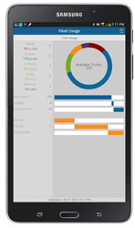
The app, available on iOS and Android devices, provides a dashboard of real-time data, including order status, ticket details, order timelines, fleet analytics and performance, vehicle location, trip status, signal health, driver hours and performance. The data can be filtered and viewed using maps, graphs, charts and timelines for a visual representation of critical information.
TrimView Direct is organized in modes: delivery, fleet and driver. Navigating using scrolling menus and toggle screens, users can tap or swipe the page to instantly find and record data.
For example, managers use the fleet dashboard to see average cycle miles, current fleet usage, average costs, signal health and delivery performance for a fleet, plant, truck or group of trucks. Sales and account managers who are on a customer site can reference data in the field, including order status, performance, timeline and ticket information.
“Our work with BCMI empowers today’s mobile worker,” said Glenn Bramer, director of marketing for Trimble Construction Logistics. “As we continue to develop solutions that transform the way work is done, we must look at how we can extend valuable information beyond desktop users and enable management to make smarter decisions anytime, anywhere. TrimView Direct is a bold step in this direction.”
“Coupling Trimble’s expertise in collecting real-time data for improved productivity with our movement to modernize the tools and processes for ready mix operations, we have enabled the entire concrete production chain, both human and machine, to interact with actionable, real-time information,” said Bernie Benson, co-founder of BCMI.
Two new products have found ways to turn smartphones into personal protection devices. One of the two products includes a wearable monitor.
Photo: First Sign Technologies
Mace Wear Pod
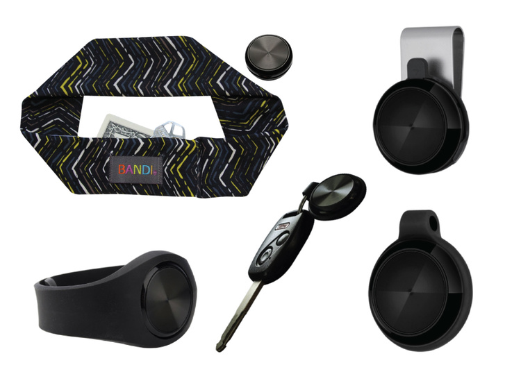
The Mace Wear Pod uses a wearable device in conjunction with a smartphone app. First Sign Technologies, in partnership with Mace Wear, has launched the Mace Wear Pod, which acts as a personal security system against violent crimes. At the first sign of a violent attack, an assault alarm is activated and the speaker lets the attacker know that evidence has been collected and help is on the way. The device automatically begins to collect evidence, take photos, and call for help, which will help identify, apprehend, prosecute and deter attackers, the makers say.
The Mace Wear Pod can be worn in five ways as a headband, wristband, key chain, belt clip and pendant. For those not wearing the pod, the mobile app, which can be downloaded on iPhone and Android, can also be activated in three ways, by hitting the alert button, by shaking your phone, or by setting a time to check-in — the alarm is activated if the check in doesn’t take place.
First Sign Technologies was launched in January 2014. Following a successful crowd-funding campaign, the product is now available with one year of monitoring service for $120.
“There is a demand for personal protection and with the advances in wearable technology, we want to create products that give peace of mind,” said First Sign President Rachel Emanuele. “Mace is an ideal partner to help us expand our product line and help promote safety to all who seek it.”
The products are expected to be available in more than 1,000 stores such as Dick’s Sporting Goods, Sports Authority and Sears. Demonstration videos are posted here.
Photo: STOP-ATTACK
STOP-ATTACK
Another new app launching this month, STOP-ATTACK, uses smartphone technology to send alerts in case of bullying or harassment. STOP-ATTACK, available on both Android and Apple platforms, records audio and video evidence and alerts contacts of trouble in a matter of seconds, sending GPS coordinates to a designated Panic List and first responders.
“We need to stop the senseless violence and assaults in this world,” said Anthony “Tony” Bright, the creator of STOP-ATTACK. “Our hope is that STOP-ATTACK.com will be a powerful tool in this struggle. The app has been developed with simplicity as a core feature, so that even younger children can be protected, giving parents much-needed peace of mind.” The CEO will be presenting the STOP-ATTACK app at the Pre-Grammy Awards VIP Gift Lounge and The Oscars Gift Lounge hosted by GBK productions this February.
The app can be downloaded in the Google Play or iTunes store, and is available for free now until Feb. 8, 2015.
STOP-ATTACK users will be able to customize many aspects of the app, such as creating a “Panic List” of people for the app to contact in an emergency, from friends and family to local first responders. When a user activates STOP-ATTACK, the app instantly begins recording live audio and video and uploading the stream to the cloud. Panic List contacts and designated first responders are notified immediately or after a brief, user-determined delay. The app will send the contacts a link with the GPS location and the recording of the incident.
A hot key allows for quick and discrete activation of the STOP-ATTACK app. For instance, a bully need not know they’re being recorded until presented with the evidence by a school authority. On the other hand, it’s sometimes advantageous to let everyone know that STOP-ATTACK is recording; users can choose for the app to play an alarm sound and turn on the camera light when activated, a strong deterrent to a would-be attacker.
The developers of STOP-ATTACK have created a pair of explainer videos to showcase exactly how the app works in typical usage scenarios: “Always Be Prepared,” “Bullying.”
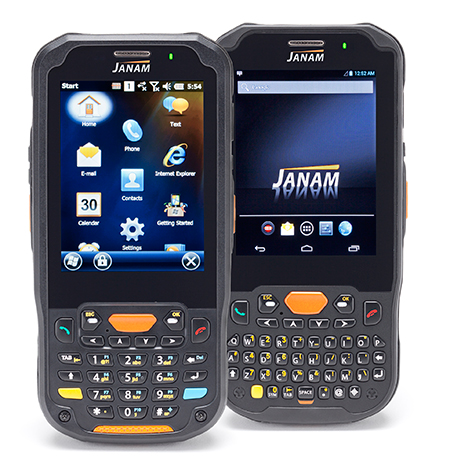
The Janam XM5 series has both Windows and Android OS.
Janam Technologies LLC, a provider of rugged mobile computers that scan barcodes and communicate wirelessly, today announced the launch of its XM5 family of rugged mobile computers. Designed to maximize the mobility investments of enterprise and government organizations, the new XM5 has high-sensitivity GPS and Assisted GPS, and supports Windows Embedded Handheld 6.5 and Android operating systems on the same hardware.
Having both OS enables customers to choose the OS strategy and application migration schedule that best meet their mobility requirements, Janam said.
The XM5 provides the power and flexibility required by mobile workers in field sales, field service, public safety, direct store delivery and transportation and logistics markets, Janam said. Customers can choose between integrated, best-in-class, 1D/2D imager or 1D laser scanner for instant decoding of the hardest-to-read barcodes. Embedded RFID and NFC reading capabilities ensure more efficiency and accuracy in a variety of applications including inventory management, asset tracking, personal identification and mobile point of sale.
“Janam’s XM5 is one of the few rugged mobile computers that allows a customer to migrate from Windows to Android without purchasing new hardware,” said Harry B. Lerner, CEO of Janam. “Packed with all the features that enterprise requires, built to exacting standards of quality and available at an attractive price point, the XM5 catapults Janam to the lead position among hardware providers that not only listen to what customers need, but deliver to those requirements.”
The XM5 comes with either a QWERTY or Numeric keypad and a specially-fortified 3.5-inch VGA display that withstands heavy-duty use. It also offers 802.11a/b/g/n dual-band WLAN and 4G-ready UMTS/HSPA+/HSDPA/HSUPA/GSM WWAN communications for access to high-quality and reliable voice and data inside and outside the four walls.
Built to withstand the rigors of everyday use in the enterprise, the XM5 is sealed to IP65 standards, can withstand five foot drops to concrete and is UL-certified for hazardous environments. In addition, the XM5 ships with a 4000mAh rechargeable Li-ion battery, providing extended battery life as a standard feature, not an optional one.
XM5 Features
Android 4.2 and Microsoft Windows Embedded Handheld 6.5 operating systems
Eos Positioning Systems has introduced a new line of high-accuracy GNSS receivers for smartphones and tablet computers, including both sub-meter and RTK performance for all mobile platforms: iOS, Android, and Windows.
Eos’s entry-level product, the Arrow Lite, is Bluetooth compatible with all mobile devices.
The Arrow 100 is Eos’s advanced real-time, sub-meter GNSS receiver that utilizes both GPS and GLONASS, and is expandable to Galileo, Beidou and QZSS. It offers superior tracking under tree canopy, around buildings and in rugged terrain, the company said. In addition to supporting SBAS in North/Central America, Europe, Northern Africa, Japan, India and Russia, the Arrow 100 also supports OmniSTAR’s worldwide, real-time sub-meter service.
The most advanced Arrow receiver is the Arrow 200, a dual-frequency, multi-constellation RTK GNSS receiver capable of 1-cm accuracy in real time. The Arrow 200 is an iOS-compatible RTK and OmniSTAR receiver that works with all models of iPads and iPhones via wireless Bluetooth connection. An iOS NTRIP app that allows the user to log into any available RTK network. The Arrow 200 will provide quality RTK performance for years to come because it supports current and future satellite constellations: GPS, GLONASS, Galileo, BeiDou and QZSS, the company said. It also supports OmniSTAR’s G2, XP and HP real-time worldwide decimeter services.
“After spending more than 12 years designing high-accuracy Bluetooth GNSS receivers, I believe Eos has set the new standard for high- accuracy GNSS receivers that work across all mobile platforms, no matter if it’s iOS, Android or Windows,” said Chief Technology Officer Jean-Yves Lauture.
All Arrow receivers employ long-range (1-km) universal Bluetooth connectivity so the user can interface to any brand of smartphone or tablet, whether it’s iOS, Android, or Windows-based. A variable-power Bluetooth implementation allows the Arrow receivers to communicate up to one kilometer from the mobile device.
Arrow receivers have been optimized to run all day on battery power. The battery pack is field-replaceable and rechargeable separately. It contains smart charging logic so expensive battery chargers are not needed.
All Arrow receivers have been designed to meet IP-67 specifications for immersion in water and are completely dust-proof so they will survive in the harshest environments.
The Arrow receiver product line is targeted at high-accuracy applications like GIS, environmental, agriculture, electric/gas/water utilities, surveying, machine control, and federal/state/local government.
India-based GNSS device maker Stesalit has introduced a SXgeoCloud mobile mapping application. SXgeoCloud provides a full GIS data collection suite with active sync to leading enterprise GIS systems through a mobile and cloud architecture. SXgeoCloud will be available with the Sxtreo series of GPS/GNSS devices from Stesalit and is now available only to customers in India.
SXgeoCloud is compatible with all the SXtreo rugged GNSS field computers and other field GNSS devices. SXgeo is the offline mobile GIS software suite from Stesalit.
The Android-based mobile mapping system of SXgeoCloud supports over 50 OGC compliant formats and background raster Web Mapping Services. It allows users to acquire geospatial data including points, lines and polygons, along with their attributes with the advantage of creating new objects in the field. It supports all editing features and is flexible for users to work on offline and online basis with active sync to the SXgeoClould Server.
The cloud server of SXgeoCloud combines project creation, data-collection management, active sync, and archival. Data sets acquired or new objects created in the field are automatically updated in the cloud GIS server in real time, and can be actively synced with the user’s enterprise GIS in real time. Users can customize the data-capture properties, attributes, and forms to match their own enterprise database requirements. With SXgeoCloud, integration with industry-leading GIS server systems is seamless.
SXgeoCloud ensures consistently high-quality data import and export in a variety of GIS and CAD formats, increasing field work efficiency, productivity and the accuracy of GNSS data.
Esri today released its highly anticipated Android version of Explorer for ArcGIS. The native Android app offers access anywhere to data-rich, visually stunning maps. It combines Esri mapping software with the popular mobile-device platform Android.
Governments, utilities, natural resources, and other commercial businesses have already used Explorer for ArcGIS on iOS and OS X to brief stakeholders, tell stories, and find assets. A sketch function enables highlighting and collaborating. In addition, presentation features make map slides easy to navigate and allow teams to interact with mapped information.
The app intelligently scales to device size. Any owner of an Android smartphone or tablet (version 4.0 and up) can explore Esri public maps from anywhere. Examples of public maps users can view include data-rich views of the Bakken oil fields of North Dakota, Alaska’s glacial retreats, and life expectancy by country.
Users with an ArcGIS Online subscription or Portal for ArcGIS account can use the full power of the app, gaining access to their own and their organization’s maps and data.
Explorer for ArcGIS draws on its native Android operating system with sharing capabilities, including e-mail, text messaging, and push notifications.
A Windows version of Explorer is set to be released next year. It will add to Esri’s growing suite of mobile apps that puts intelligent maps into the hands of people with zero to high GIS experience.
Android users can test-drive Explorer for ArcGIS by downloading it for free from the Google Play Store. Learn more about Explorer for ArcGIS at esri.com/explorerapp.
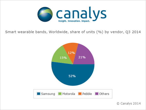
Nearly 5 million smart and basic wearable bands shipped in Q3 2014, with total unit shipments increasing 37% quarter on quarter as Android Wear made its mark for the first time, according to a report by independent analyst company Canalys.
Motorola Mobility’s Moto 360 was by far the most successful of the initial Android Wear devices, accounting for more than 15% of the smart band market according to Canalys estimates. Despite being supply-constrained, its appealing design helped it to easily out-ship other Android Wear products.
LG has responded to early interest in the Moto 360 by quickly adopting a circular display with the G Watch R.
Meanwhile, Samsung remained the overall smart band market leader, and the company has already begun to experiment with larger display sizes and cellular connectivity with the Gear S, its sixth smart band.
Though the platform is still young, Android Wear will be fundamental to the development of the market, as it is poised to be one of the two dominant wearable operating systems outside of China, alongside Apple’s Watch OS. But Google will need to redesign the Android Wear user interface before the platform can achieve its true potential.
‘The announcement of the Apple Watch late in the quarter has likely had an effect on sales of existing devices, as some consumers will choose to wait for Apple’s wearable,’ said Canalys Analyst Daniel Matte. ‘The smart band market was flat between Q2 and Q3, but with an installed base of over 1.8 billion Android smart phones, there is a huge potential market of Android users not considering an Apple Watch.”
Fitbit and Jawbone held onto their first and second place positions, respectively, in the basic band market for the quarter, and both have just announced new products. Garmin passed Nike to take third place in shipments, while Xiaomi and Huawei also overtook the one-time market leader and rounded out the top five. “Low-end basic bands providing simple activity tracking functionality are becoming increasingly commoditized, and will flood the market heading into the holidays, especially in China,” said Canalys Analyst Jingwen Wang. ‘To combat this, Fitbit, Jawbone and others have attempted to make basic bands smarter, adding various smart watch features and increasing the sophistication and integration of sensors.’
Google Fit, Microsoft Health and the Samsung Digital Health Platform have all recently been announced in response to Apple’s HealthKit. While the new Microsoft Band does not have strong hardware appeal, Microsoft’s cross-platform cloud services approach is a wise strategy, and the company is importantly staking its relevance early in a new market. There is tremendous opportunity for brand new services on wearable platforms, and not just in the area of health and fitness. Expect developers to eagerly embrace Apple’s WatchKit SDK, expected to be released in early 2015.
Wearable band shipment data is taken from Canalys’ Wearable Technology Analysis service, which provides quarterly market tracking, including country-level estimates. Canalys defines basic wearable bands as devices serving a specific set of purposes that act as accessories to smart devices, are designed to be worn on the body and not carried, and that cannot run third-party computing applications. Smart wearable bands are multi-purpose devices that serve as accessories to smart devices, are designed to be worn on the body and not carried, and are capable of running third-party computing applications. Bands are wearables designed to be wrapped around the body and do not include activity trackers in the form of clips.
Jerker Hellström, founder and CEO of Handheld Group.
Jerker Hellström, founder and CEO of Handheld Group, has identified three key trends in mobile computing in 2015. Handheld is a maker of rugged computers for professionals.
His predictions:
1.Larger displays even for rugged mobile computers.
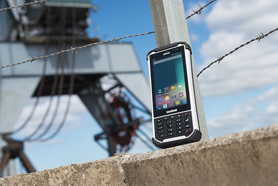
“Rugged laptops, tablets, PDAs and smartphones continue to be the fastest growing market mobile computer segment, and just like the screen size of smartphones for the mass market has increased, so will the displays of rugged computers. Screen size is the “$64,000 question” in the rugged computer segment — it is a major consideration for all users, but it is also linked to the application and how data and information are presented, both in terms of how it is captured and how it is communicated to the end user. I foresee a stronger demand for maximum screen real-estate in the smallest, lightest possible form factor. (One real-life example would be the recently launched Nautiz X8 by Handheld with a huge 4.7-inch display for an IP67-rated rugged device).”
2.Higher IP ratings.
“Mobile computers across all market segments are increasingly being manufactured, and marketed, as more durable, more rugged and with higher IP ratings (ingress protection against water and dust).This a function of computers, tablets and smartphones being with us all the time, everywhere. The consumers demand durable devices that can be knocked around a bit! But it has also become a marketing gimmick. Some devices are now advertized as having the previously unattainable IP68 rating. But do the customers actually understand it? It actually means nothing unless the manufacturer informs us of the submerged time and depth. I expect a continued upwards ‘IP rating creep’ but also an invigorating discussion about the definition and value of IP ratings and the tests carried out on mobile computers.”
3.Increasing interest for Android.
“Microsoft Windows Mobile or Windows Embedded has for a long time been the operative system of choice for rugged mobile devices, albeit with increasingly stronger competition from Android. 2015 will be the year when he industry truly embraces Android. The rapid growing of Android consumer phones has standardized the Android user behavior and generated a spillover effect to the industrial sector. There is an increase of industrial software being developed for Android, boosted by the first generation industrial Android devices. Also, Android can take advantage of powerful multicore CPUs in a way Windows Embedded Handheld has not been able to.“
The Nautix X8 rugged Android handheld.
Jerker Hellström is the founder and CEO of Handheld, a manufacturer of rugged mobile computers, PDAs and smartphones.Heis a pioneer and industry veteran in the mobile rugged computer industry. In both entrepreneurial and managerial positions, he has more than 25 years of experience from developing, designing, manufacturing and marketing rugged computers globally. Jerker´s educational background is in engineering and computer science.
CSR plc today announced the launch of its SiRFusion Software Development Kit (SDK) for Android application developers. The solution enables indoor positioning for Android developers looking to create next-generation apps.
Developers can now leverage the SiRFusion library to rapidly integrate new location-based capabilities and services such as indoor location tagging and analytics for social networking applications, indoor navigation, lone worker efficiency and safety capabilities, as well as indoor asset tracking and targeted e-commerce services.
CSR is being acquired by Qualcomm, with the transaction expected to close by the end of the summer of 2015.
Mobile applications with integrated SiRFusion can now deliver the ubiquity of outdoor navigation to indoor environments without costly surveys or infrastructure upgrades. SiRFusion combines real-time Wi-Fi signals, satellite positioning information, pedestrian dead reckoning, and the company’s cloud-based CSR Positioning Center to calculate accurate indoor location. SiRFusion technology provides the accurate indoor position fixes needed to make continuous indoor navigation a part of everyday life. The system automatically crowd-sources a venue’s indoor Wi-Fi signatures as consumers walk through the location, and it has also been architected to accommodate future proximity and location technologies such as Bluetooth Smart beacons, Wi-Fi Round Trip Time (RTT), and Indoor Messaging System (IMES).
“Offering indoor positioning accurate enough to be useful has been a challenge that the industry has been trying to solve for many years,” said Anthony Murray, Senior Vice President, Business Group at CSR. “But with consumers coming to expect anytime-anywhere positioning wherever they are, our customers have continued to express a growing interest for accurate indoor positioning without the need for additional infrastructure. With our SiRFusion Software Development Kit, we have, for the first time, made indoor location a reality for developers who want to deliver innovative location-based products and services without proprietary infrastructure.”
SiRFusion for Android can be integrated into any app running on Android version 4.4 or later. The SDK will be available for download from www.csr.com in Q1 2015, and will include the SiRFusion library, API descriptions, and a Developer’s Guide. CSR will demonstrate SiRFusion for Android at the Location and Context World conference December 2-3, held at the JW Marriott in San Francisco, and at Consumer Electronics Show (CES) in Las Vegas January 6-9, 2015. To schedule a private briefing and demo at either event, contact [email protected]
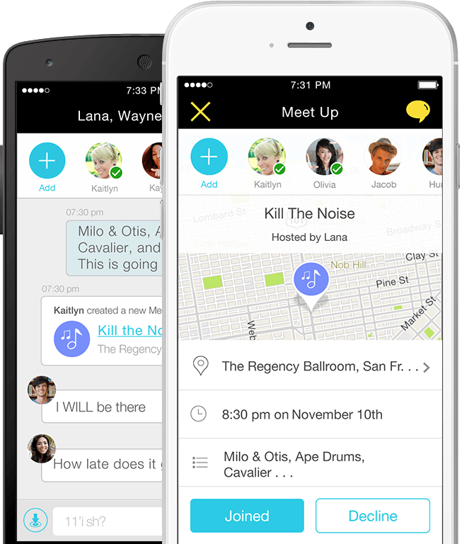
Location-based services company Telenav has announced new capabilities and updates to its free Scout mobile application that make the process of connecting and getting together easy and fun. Scout users can now manage the details of creating an event, contacting and inviting friends, choosing a location, communicating with the group and navigating, all within the updated Scout application. Scout is powered by OpenStreetMap.
For iOS devices, the new app experience will offer predictive, intuitive traffic push notifications for users’ everyday trips, eliminating the need to manually check for traffic delays. The newest version of Scout is now available from Google Play for Android and iTunes for iOS.
The results of a new survey from Telenav underscore the common pain points of planning events, meet-ups and meetings for consumers — especially Millennials — which Telenav is aiming to help alleviate with the updated Scout app. Nearly half (49 percent) of Millennials reported that they would find it useful to have a single solution that enables them to plan an event, communicate with attendees while they’re en route, and see each other’s estimated time of arrival.
“Mobile users have come to expect more out of their navigation devices and applications,” said Rohan Chandran, president and general manager of Telenav’s mobile division. “Navigation alone is critical, but it is a commoditized utility. We are looking to embrace the things that people really care about — the experiences in real life for which you navigate. Getting together should not be hard work, and we are trying to solve that. Scout is the new way people connect, get together, and go places in real life. It’s the only app that takes you all the way from chatting, to making event plans, to getting together in person, complete with voice-guided GPS along the way and everyone’s whereabouts and ETA pinpointed on the map.”
Scout’s new in-application features include:
Socialized Navigation Experience. In addition to offering invitees voice-guided, turn-by-turn directions to the event destination, Scout offers real-time location and ETA insights so guests are able to view the positioning of other guests on the navigation map. This prevents a barrage of “Where are you?” texts and calls while en route — and eliminates questions about where directionally challenged or perpetually tardy friends are.
Easier Meet-Up Invitations. Scout replaces what typically requires multiple applications by conveniently taking care of all the details of getting together, from inviting guests on their contact lists, to picking a day, time and location. “Did I get an invite?” and “what time is the event taking place?” are the last questions that organizers will be asked.
Group Chat. For the friend who is always left out, Scout users can now chat with all of the other event attendees directly within the app, allowing them to avoid juggling multiple text and phone conversations, and easily adjust and discuss the details of an event.
Predictive, Personalized Traffic Reports (iOS Devices Only). Users can schedule traffic report updates informing them of road conditions for their regular drives, and recommended alternate routes.
Carlson GIS360 for Android, new from Carlson Software and Carlson EMEA, is a mobile field GIS-GPS tool that uses both GIS and surveying technologies for field data collection. The app is designed to be easy to learn and easy to use, Carlson said.
“Taking advantage of the graphics processing power of Android devices, GIS360 now includes an innovative 3D viewer so the user can see data and models in 3D on site,” said David Loescher, Carlson U.K. sales director and director of GIS360 development.
In addition to allowing field crews to navigate maps and collect and report data in the field, GIS360 provides the data and fully rendered models of mines, earthworks and pipe networks that can be viewed in 3D. The software’s Siteview function uses the Android devices’ built-in GPS, compass and gyros to give the user the view of the site in front of him.
Carlson GIS360 provides a wireless connection to any map server of choice, so users are never without a map. This saves considerable time and effort as field crews can verify that all of the data collected is accurate before leaving the site, Carlson said. No costly site revisits are necessary and no office work is needed.
The software’s cloud options provide backup for users’ data, enabling it to be shared between field and office in real time. GIS360 goes beyond positioning with a range of tools for mobile workforce management, GPS data collection, tracking and asset maintenance.
On an Android tablet or smartphone, Carlson GIS360 for Android can take GIS data anywhere. The built-in GPS and compass instantly calculate what the user is looking at and then displays the data automatically.
“The GIS360 development team set out to make the collection of asset information easier and more efficient by combining the power of GIS360 with affordable Android devices,” added Loescher. “The result not only saves a lot of field time, but also makes the process far easier for everyone concerned.”
 Mojio, an open platform for connecting cars, has announced a partnership with Dooing, a new team management platform for businesses that can dispatch jobs and track teams.