Carlson GIS360 for Android, introduced at InterGeo this week in Berlin, is a mobile field GIS-GPS tool that utilizes both GIS and surveying technologies for field data collection.
“Taking advantage of the graphics processing power of Android devices, GIS360 now includes an innovative 3D viewer so the user can see data and models in 3D on site,” said David Loescher, Carlson U.K. sales director and director of GIS360 Development.
In addition to allowing field crews to navigate maps and collect and report data all in the field, GIS360 provides the data and fully rendered models of mines, earthworks and pipe networks can that can be viewed in 3D. The software’s Siteview function uses the Android devices’ built-in GPS, compass and gyros to give the user the view of the site that is in front of him.
Carlson GIS360 provides a wireless connection to any map server of choice, so users are never without a map. This saves considerable time and effort as field crews can verify that all of the data collected is accurate before leaving the site. No costly site revisits are necessary and no office work is needed.
The software’s “cloud” options mean that users’ data is always backed up with the ability to share between field and office in real-time. GIS360 goes beyond just positioning as it includes a wide range of tools for mobile workforce management, GPS data collection, tracking and asset maintenance.
Used on an Android tablet or smartphone, Carlson GIS360 for Android can take GIS data anywhere, Carlson said. The built-in GPS and compass instantly calculate what the user is looking at and then displays the data automatically.
“The GIS360 development team set out to make the collection of asset information easier and more efficient by combining the power of GIS360 with affordable Android devices,” added Loescher. “The result not only saves a lot of field time, but also makes the process far easier for everyone concerned.”
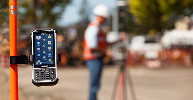
Handheld Group, a manufacturer of rugged mobile computers, has launched the Nautiz X8 rugged PDA. The Nautiz X8 is a handheld computer with superior processing power, screen performance and battery life, the company said. It is built for tough field conditions primarily in GIS, land surveying, public safety, forestry and the military.
The Nautiz X8 is built to enable efficient and reliable data collection in tough environments. It has an IP67 ingress protection rating, which means it offers complete protection against dust and sand and can withstand immersion in water. It also meets stringent MIL-STD-810G military test standards for overall durability and resistance to humidity, shock, vibration, drops, salt and extreme temperatures.
The Nautiz X8 features a high-performance Texas Instruments 4470 dual-core 1.5 GHz processor. It has 1 GB of RAM, 4 GB of iNAND Flash and a 5200 mAh Li-ion battery that lasts up to 12 hours on a single charge. It comes with a choice of operating systems — Android 4.2.2 or Windows Embedded Handheld 6.5.3.
The device has a large 4.7-inch ultra-bright capacitive multi-touch screen with chemically strengthened Asahi Dragontrail glass, offering users brightness and protection in any field condition. The unit has an ergonomic design and weighs 490 grams (17.3 ounces).
The Nautiz X8 has a dedicated u-blox GPS receiver, Bluetooth 2.0 and 802.11b/g/n WLAN functionality, as well as connectivity through GSM/UMTS or CDMA phone data transmission. A built-in 8-megapixel camera with autofocus and an LED flash lets users capture visual data quickly and easily. This handheld also features an open architecture and an extension cap system that allows for additional hardware connections such as sensors, radios and other add-ons.
Orders for the new Nautiz X8 can be placed immediately. First deliveries will begin in November.
The Nautiz X8 rugged handheld will be shown first at WEFTEC in New Orleans, followed by InterGeo in Berlin.
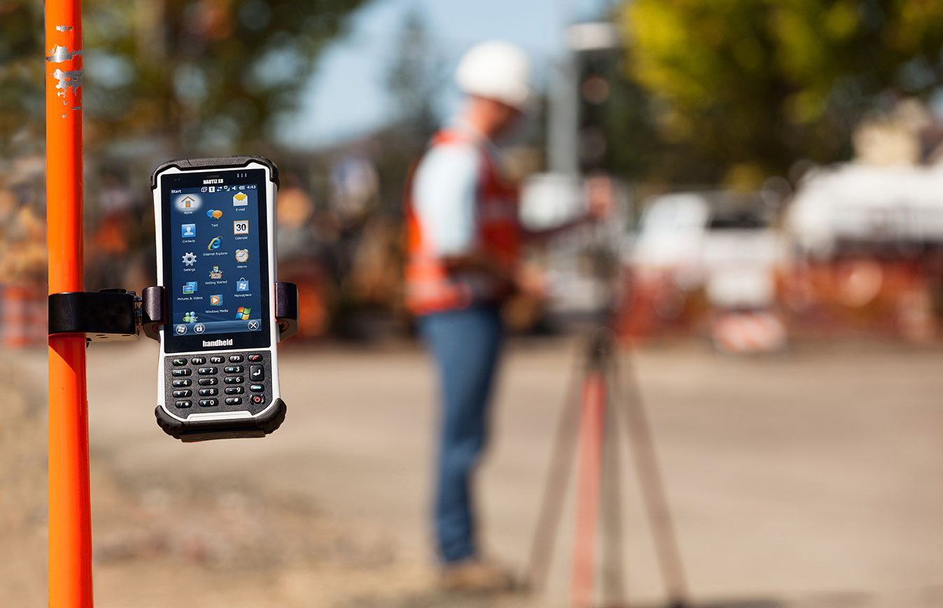
Handheld Group, a manufacturer of rugged mobile computers, has launched the Nautiz X8 rugged PDA. The Nautiz X8 is a handheld computer with superior processing power, screen performance and battery life, the company said. It is built for tough field conditions primarily in GIS, land surveying, public safety, forestry and the military.
Photo: Handheld Group
The Nautiz X8 is built to enable efficient and reliable data collection in tough environments. It has an IP67 ingress protection rating, which means it offers complete protection against dust and sand and can withstand immersion in water. It also meets stringent MIL-STD-810G military test standards for overall durability and resistance to humidity, shock, vibration, drops, salt and extreme temperatures.
The Nautiz X8 features a high-performance Texas Instruments 4470 dual-core 1.5 GHz processor. It has 1 GB of RAM, 4 GB of iNAND Flash and a 5200 mAh Li-ion battery that lasts up to 12 hours on a single charge. It comes with a choice of operating systems — Android 4.2.2 or Windows Embedded Handheld 6.5.3.
The device has a large 4.7-inch ultra-bright capacitive multi-touch screen with chemically strengthened Asahi Dragontrail glass, offering users brightness and protection in any field condition. The unit has an ergonomic design and weighs 490 grams (17.3 ounces).
The Nautiz X8 has a dedicated u-blox GPS receiver, Bluetooth 2.0 and 802.11b/g/n WLAN functionality, as well as connectivity through GSM/UMTS or CDMA phone data transmission. A built-in 8-megapixel camera with autofocus and an LED flash lets users capture visual data quickly and easily. This handheld also features an open architecture and an extension cap system that allows for additional hardware connections such as sensors, radios and other add-ons.
Orders for the new Nautiz X8 can be placed immediately. First deliveries will begin in November.
The Nautiz X8 rugged handheld will be shown first at WEFTEC in New Orleans, followed by InterGeo in Berlin.
Trimble has announced three new asset inspection software solutions for heavy civil contractors—Trimble Inspector, Trimble Inspector Pro and Trimble Asset Manager.
Trimble Inspector is a free mobile app that allows equipment managers to easily inspect assets in real-time using their smartphone or tablet.
Trimble Inspector Pro, the premium, subscription version of Trimble Inspector, is used to wirelessly aggregate and share asset condition across multiple sites using Trimble Asset Manager office software.
Trimble Asset Manager software gives contractors the ability to store the inspection data of all assets in a centralized, Web-based database for accurate reporting and documentation.
“Contractors can achieve significant cost savings by proactively scheduling asset maintenance with Trimble’s new inspection solutions,” said Alan Sharp, business area director for Trimble Heavy Civil Construction. “Trimble takes the guesswork out of asset maintenance and puts the control back in the hands of the equipment manager.”
Trimble Inspector, a free mobile app, runs on both Android and iOS smartphones or tablets for daily, weekly and monthly visual inspections using a library of equipment, machine and vehicle types, makes and models, and inspection checklists. Reports containing current visual health status, hours, odometer reading and general condition can be promptly emailed to equipment and maintenance managers. The reports, along with photos, can then be retained for legal documentation of health and safety standards compliance, and for audit purposes. In addition, Trimble Inspector assists with scheduling maintenance to reduce equipment downtime and unplanned stoppages. The app is also ideal for trade-in or auction house inspections of used equipment.
Trimble Inspector Pro has all the functionality of Trimble Inspector, with the added benefits of customized inspection reports to meet health and safety requirements, and comprehensive maintenance reports for service crews. Equipment managers can record equipment service issues and notify site management staff of equipment status on multiple sites within seconds of the completed inspections. Trimble Inspector Pro requires a subscription to Trimble Asset Manager office software to access the additional functionality.
Trimble Asset Manager is a software as a service (SaaS) application used in the office to integrate, store and report asset condition data collected in the field by Trimble Inspector Pro. Asset information is kept in a secure, centralized online database accessible by authorized users in the company. Users can create asset records, document inspections and customize reports so managers get the data they need quickly and easily.
Trimble Inspector and Trimble Inspector Pro are available now worldwide from the Google Play Store or the Apple App Store. Trimble Asset Manager is available now globally through Trimble’s SITECH Technology Dealer Channel.
A few weeks ago at the Esri 2014 International User conference in San Diego, California, we conducted our first live event webinar from a Plexiglas booth sitting among many of the 14,000+ attendees buzzing around inside the San Diego Convention Center.
The webinar focused on high-precision GNSS on mobile devices (iOS/Android/Windows), unmanned aerial systems (UAS), and real-time GIS transactions. These are hot topics in the geospatial world, and that was confirmed when I received about 100 pre-webinar questions and more than 100 post-webinar questions.
In my article this month, I’ll do my best to provide answers to the questions asked. If I don’t get to your question, or if you have another, please email me at [email protected].
First of all, if you didn’t attend the webinar and would like to view the recording, you can register here and you’ll be provided a link to view it. It’s a great, interactive discussion. I grabbed Sharad Garg, iOS consultant, from the Esri show floor to talk about the intricacies and complexities of using GNSS receivers on iPads and iPhones.
Without further delay, following are some of the more popular pre- and post-webinar questions I received.
Mobile Devices
First, I’ll start with the questions about mobile devices and high-precision GNSS.
1. Will Android be the dominant mobile tablet platform in the Enterprise?
It’s hard to say. I recently met with a group of enterprise IT professionals and we were discussing this issue. Basically, the group was equally divided into thirds. One third were using Android. one third were using iOS, and one third were using Windows.
Android advantages: Lots of mobile devices available that run Android. Android disadvantages: Open source = non-standard implementations, so app software may not run on every device; security concerns.
iOS advantages: Consistent user interface, consistent software development environment, popularity of iPad and iPhone. iOS disadvantages: Closed ecosystem (very limited number of tablets); doesn’t interface to devices (such as GNSS) that haven’t been through the Apple certification process; security concerns.
Windows advantages: Security; lots of legacy apps and utilities written for Windows. Windows disadvantages: Limited number of tablets being deployed based on Windows.
For enterprise organizations, data security is a huge concern. Since Android is open source and gaining the most market share (at least in the consumer market), it’s got a target on its back for hackers. That’s the biggest concern I hear from corporate IT professionals. How will Android device developers address that, or will they? The consumer market for Android devices is exploding regardless of security. Do they even care about the enterprise market? Apparently Apple does as it recently signed an agreement with IBM to address the enterprise market, with IBM committing to deploying more than 100 enterprise solutions for iOS.
Site of the webinar broadcast from the Esri UC.
2. Which mobile platform is the most universal/easy to integrate with GNSS receivers?
Out of the box, Windows and Windows Mobile devices are still the easiest to interface to external GNSS receivers for the average consumer. Using Bluetooth, serial or USB, NMEA (or proprietary binary) data flows easily via the device com port or virtual com port. If you’re using a Bluetooth interface, there is some inconsistency among mobile devices due to the different versions of Bluetooth management software used on mobile devices, but it’s workable, and worst case you can buy an inexpensive third-party Bluetooth software manager like BlueSoleil.
With the use of an app such as Bluetooth GPS that allows you to select an external GNSS receiver, connecting your Android device to an external Bluetooth GNSS receiver is relatively painless.
Apple products are the toughest to integrate with external GNSS receivers via Bluetooth. Each GNSS receiver has to be specifically designed with an Apple Bluetooth authentication chip and be subjected to the Apple certification process, which can be lengthy and costly. This is the reason why you see very few Bluetooth GNSS receivers available for Apple products. The good news is that once the GNSS receiver is approved, the Bluetooth connection happens automatically when the GNSS receiver is in range of the Apple device. No com port config, no baud rate to worry about, etc.
3. What is available on Android that will make my smartphone a practical and useable tool that can assist in collecting professional data?
First of all, you need to find a high-precision Bluetooth receiver to connect to your Android device. Then, establish the Bluetooth partnership between the Android and GNSS receiver (scan for Bluetooth devices, enter passcode, etc). Once you have that, download the Bluetooth GPS utility I mentioned above and it will allow you to select which GNSS device to use (external vs. internal). Once you’ve selected the external GNSS receiver and connected to it via Bluetooth, every location app on your Android device will use the high-precision GNSS receiver for location.
This applies to an Android tablet or Samsung Galaxy phone. Take a look at this article to see how I ran RTK on a Samsung Galaxy using a Bluetooth RTK receiver.
Today’s challenge is finding “professional” GIS data collection apps that run in the Android environment. There are a few, but the selection is limited. Esri has its Collector for ArcGIS app that runs on Android, but it requires an ArcGIS server backend or ArcGIS Online account. Other data collection apps like Fulcrum and Amigocloud run on Android as cloud-based services.
4. Is there an actual GPS receiver within smartphones, or are they triangulating off of cell towers?
There’s a GNSS receiver in virtually every smartphone manufactured. The GNSS chips are so cheap (a few dollars) compared to the functionality gained that it wouldn’t make sense not to design a GNSS receiver in a smartphone. Now, just because there’s a GNSS chip in each smartphone doesn’t mean it’s the only technology used for location. For example, Apple iOS uses multiple data sources to determine the location at any given time. It will use a combination of cellular triangulation, Wi-Fi IP address, and internal GNSS receiver and external GNSS.
5. Which applications do you see requiring RTK accuracy within the mass-market applications?
A couple of years ago at the GPS World Leadership Dinner at the ION GNSS conference in Nashville, Dr. Todd Humphreys of the University of Texas at Austin predicted that you’ll have RTK (real-time centimeter accuracy) capability on your smartphone by the year 2020. I agree with his prediction, and I think we’ll see inexpensive Bluetooth RTK “pucks” well before 2020, as I’ve written before.
Often, I get the question raised above. Who needs RTK on a mobile phone?
I can’t tell you any more than that in the early 1970s when GPS was first being conceived, not one could tell you what GPS would be used for today. I love the following quote from Steve Jobs: “People don’t know what they want until you show it to them.”
6. Since many devices are complete systems with GNSS inside, do you see the direction of the industry moving towards remote “add-ons” like Bluetooth receivers?
Bluetooth receivers are certainly trending, and it’s primarily driven by the explosion of powerful yet inexpensive tablets and smartphones in the past five years, starting with the iPad/iPhone, and now with Android devices and smartphones in general. People want to use their consumer devices in a professional capacity and some need high-precision GNSS receivers, so that’s driving the demand for “add-ons” like Bluetooth GNSS receivers, laser rangefinders, and more.
Unmanned Aerial Systems
Ok, let’s transition to some questions on UAS (such as UAV, drones).
1. Do you see the FAA allowing simple operations for very low altitude UAV-sensors?
It’s difficult to speculate what the FAA will implement, but I have to think, based on its past behavior, that the initial rules will be super-conservative with minimum requirements being that a licensed pilot will be required to operate the UAS in addition to strict equipment requirements.
What’s going to be interesting to observe is what the FAA will do about the hundreds (maybe thousands) of UAS operators who will attempt (or are attempting) to “fly under the radar” and skirt the FAA rules. We’ve seen the FAA attempt (sometimes successfully and sometimes not) to crack down on some UAS operators whom it believes are violating the rules, but there have only been a handful of those cases.
2. When do you think the FAA will release rules for commercial UAV users?
I wouldn’t be surprised if the FAA issued some guidelines in September 2015, but I seriously doubt they will publish the full set of rules by then.
By the way, I attended an interesting UAS presentation at the AEC Summit prior to the Esri UC. You can see my write-up of it here.
That’s it for now. I’ve got many more questions from the audience that I’ll address in upcoming newsletters. Stay tuned and feel free to email me directly at [email protected].
Available for iPhone, iPad and Android, VIIRS View provides mobile device users a look into the type of data meteorologists and climatologists use every day to track the weather and monitor Earth’s environment.
Based on data generated by the Visible Infrared Imaging Radiometer Suite aboard Suomi NPP, VIIRS View combines visible light imagery, low-light nighttime imagery and ocean chlorophyll concentration onto a full Earth globe, rotatable and zoomable on any location on the planet.
A desktop version of the VIIRS View app, launched in February, has been downloaded more than 90,000 times.
An original large format VIIRS View interactive tabletop display is being shown at Raytheon Booth #203 at the the 30th Space Symposium, being held this week in Colorado Springs, Colorado. GPS World Defense Editor Don Jewell is providing coverage from the symposium.
The app can be downloaded by searching VIIRS View at the Google Play and Android stores, or by clicking here:
Supergeo Technologies, a provider of GIS software and solutions, has launched SuperSurv, a mobile GIS app, on the App Store and Google Play.
SuperSurv contains comprehensive GIS data-collection functions. Designed for both iOS and Android powered devices, it integrates with GIS and GPS technologies to provide functions in field survey, such as Map Display, Query, Measure, etc. With SuperSurv, the collected data can be saved as feature layer (point, line, polygon) in SHP or GEO format in offline mode. SuperSurv supports OpenStreetMap as the base map.
SuperSurv has been successfully applied in various industries worldwide, including environment protection, pollution prevention, and facility management. The free trial version is now available on Apple App Store and Google Play, allowing users to experience complete functions for seven days before purchase.
For users in North America, Supergeo has released the SuperSurv M3 version to provide easy-to-use and useful data collection and map display functions. SuperSurv M3 supports feature-layer display and offline editing functions. Furthermore, cached maps can be adopted as the base map to facilitate data capture tasks.
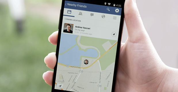
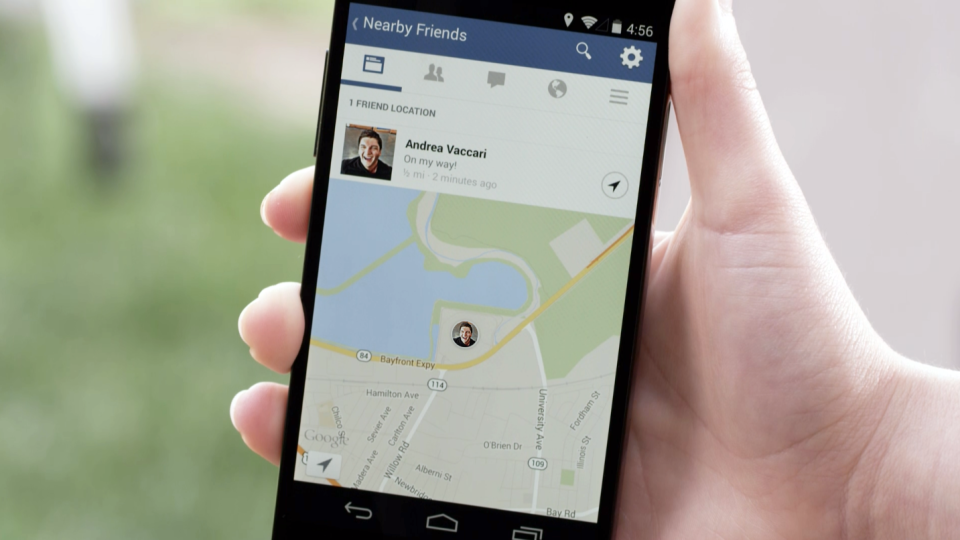
Facebook Nearby Friends feature helps people get together.
While Facebook has made big news buying companies for billions of dollars, it hasn’t been making many location-based services headlines. The recent announcement that it is rolling out a friend finder is interesting news, not only for social applications, but the potential indoor positioning markets. The news is also interesting because as many as half of Facebook users access the social media network through mobile devices.
Signaling that it does have a location strategy, as GPS World reported earlier this week, Facebook announced that it was launching an LBS offering called Nearby Friends. The opt-in service allows users to find out what friends are nearby or mobile.
Nearby Friends will be available on Android and iPhones in the U.S. market this month. In Facebook’s press announcement, apparently privacy is a big issue as the company insists it is an opt-in function.
Once users agree to use the service, they will be notified when friends are in close proximity. Users can select the friends who can see their location — and can turn the service on or off at any time.
At first glance, Nearby Friends could be a valuable tool for users looking to find friends and make plans, but the real potential could be for retailers who wish to drive in-store traffic. Users can not only invite friends to a specific business on a map, but tag other traffic.
The area or business to where the friends are traveling will be displayed on their profile. This allows the friends who opt in to recommend shops, restaurants and other things to do in the specified area.
How retailers get their message out to Nearby Friends users remains to be seen. Research company Berg Insight still says advertising will constitute the main revenues for social networking and local search market segments. However, in several published reports, users have tired of the increased Facebook advertisements.
Berg says that social networking and entertainment has now overtaken mapping and navigation as the largest location market. The company says that those services include general social networking, messaging apps, friend finders such as Nearby Friends, and games.
While Facebook could use the Location History in Nearby Friends to make money selling ads, the company says it isn’t right now. But it has to be the future — and one that, privacy issues aside, could be very lucrative for the company. It could target opt-in users with ads that are only a few feet away or in the area they will meet friends.
The Wall Street Journal reported that Facebook will leverage its user base, estimated at one billion users, to improve ad targeting, expand marketing reach, and to make more money. The company earned $1.24 billion in revenue through mobile ads for the last three months of 2013, according to published reports.
After the announcement that Facebook was launching Nearby Friends, a number of tech business articles sprung up about potential, real and imagined, privacy issues. With the predictable privacy issues comes opportunities for location startups. A new location app is touting itself as the “anti-social networking” tool. Called Cloak, and available in Apple’s App Store, it allows a user to avoid friends they want to avoid by revealing the location of contacts — while keeping the user’s position hidden.
The app, which already has been downloaded more than 100,000 times, uses Instagram and Foursquare data, and published reports say Facebook compatibility is coming soon.
Rumors about Acquisition Prove False?
Earlier this month, several tech business industry publications wrote that Israel-based indoor navigation startup ShopCloud was in talks with Samsung to sell the company for as much as $90 million. Samsung has denied the rumors.
In articles like these, red flags always include terms like “several sources familiar with the details”. The price seemed high for a young company that hasn’t launched a product, though according to published reports, it has an app called Inside.
One analyst says that the Israel tech business media frequently pumps up local companies and even creates buzz for startups — and often these reports are picked up by local journalists.
Autonomous Vehicles Will Happen, but When?
In January’s Transportation Research Board (TRB) meeting in Washington, D.C., attendees agreed that self-driving vehicles are the future. The bottom line is when is the future? “We have seen the business case for autonomous vehicles — it will be a reality. When you look at the number of lives it will save, efficiency of the network, it is very compelling,” said Kevin Link, Verizon senior vice president and general manager, China. “We have to begin a slow migration of educating consumers — one of those ways is through the connected vehicle. I don’t think consumers are there yet.”
Link talked about autonomous vehicles at the Consumer Telematics Conference, also in January, but those at TRB are mainly academics and government officials, not business executives. Most believe it will take decades, Google car aside, to have a fully autonomous vehicle on the road. Others believe that if Detroit does not take notice, they can read about Google dominating this vehicle market, not being a player in it.
In other location news:
Place, the Business of Location conference will be July 22 in New York. Executives from SK Telecom, Thinknear, Sonic Notify, Aisle411, and Factual will join Google, retailer Alex and Ani, and agency MEC North America (WPP), among others. The conference will include case studies and explore how mobile, offline tracking and indoor location will change the future of digital marketing and brand advertising. Many location conferences have died in the last two years, so it is refreshing to see a conference with a strong agenda back on the scene.
Finland-based IndoorAtlas rolled out an indoor mapping application for iOS. While iOS supports Apple’s iBeacon micro-fencing solution for indoor positioning, IndoorAtlas uses the compass chip built into smartphones and does not require external hardware such as Bluetooth beacons or Wi-Fi to determine location, the company said.
The U.S. Patent and Trademark Office awarded Apple a patent that could drive technology on the next generation iPhones. The patent describes a system that combines GPS, Wi-Fi access points, and on-board location databases to provide mobile devices positioning data in all types of environments, particularly indoor location.
It’s been two years since I wrote a column entitled Mobile Device Operating system wars: Android vs. iOS vs. Windows Mobile. After traveling and attending countless conferences and listening to a large number of mobile device users in the geospatial user community, I think it’s time to touch on this subject again, and what a crazy and confusing landscape it is. First of all, let’s frame the discussion in terms of the geospatial users, because that’s the soup we swim in.
At the end of the day, we are driven by the geospatial software we use, so this limits the type of mobile device we can select from. For example, Esri’s ArcPad runs on Windows Mobile and Windows desktop. If that’s the software you want to use, then you can’t use an Android device, an iPad, or a Windows Phone device. In another example, AutoCAD 360 for mobile, which I used a few weeks ago in the field, runs only on Android and iOS devices, not on Windows Mobile devices.
Chart Source: The Wall Street Journal, Gartner
While it appears Android is the dominant mobile operating system of the future, it depends on who you talk to. Right or wrong, some (maybe a lot of) enterprise organizations are scared of Android. They are scared because of one word: security, or more specifically, the perception of the lack of security. Android is open source, and it scares the heck out of enterprise IT (information technology) departments. It scares some to the point that they are shutting down projects that are proposing to deploy Android devices in the field. Is the fear justified? It’s probably more hyped up than it deserves, but IT folks are pretty conservative these days.
Where does that leave the enterprise organizations? iOS or Windows?
Some organizations are going with iOS, but the number of enterprise geospatial apps for iOS is very limited, and most of those that exist aren’t very powerful. They can’t even deal with datum transformations. That means the hardcore iOS enterprise users are left developing their own software, which some are doing. The other limitation of iOS is the hardware device selection. Since Apple doesn’t license iOS to anyone, you have the iPad and the iPhone and that’s about it. Not much selection.
That leaves us where we started…Microsoft Windows.
Dell Venue Tablet
My gut tells me that Windows is making a comeback among geospatial users, even though Windows operating system market share is minuscule compared to Android and iOS on mobile devices. Part of the reason is a plethora of high-quality, Windows-based tablets and pads. Recently, I’ve had the chance to handle some Windows-based tablets such as Dell Venue tablet and Panasonic ToughPad. They are nice tablets for field use. Thank Apple for driving manufacturers to produce good quality tablets at a reasonable price. The other part of the reason, and the major driver, is security. IT departments simply trust the security features that Microsoft provides more than iOS and Android. In the age of security breaches such as the recent Heartbleedbug, the emphasis on computer security is at an all-time high.
Panasonic ToughPad
Security may be the catalyst that pushes Windows back into the forefront of operating systems for the enterprise geospatial user. That’s good news for geospatial software developers. Pressure has been mounting for geospatial software manufacturers to introduce Android- and iOS-compatible versions of their software. Now, with the security issue at the forefront and the availability of high-quality Windows-based tablets at reasonable prices, developers may have some breathing space.
But wait: Which version of Windows?
Windows Mobile? Windows Phone? Windows Embedded Handheld? Windows Desktop? Windows RT?
They aren’t all the same, and they all don’t run the same software. For example, software built for Windows Mobile won’t run on Windows Phone or Windows Desktop.
Microsoft’s mobile operating system strategy has been confusing at best. In past years, it’s been clear that mobile devices run Windows Mobile. It’s not so clear any longer. Microsoft discontinued mainstream support for Windows Mobile 6.1 and 6.5 in January 2013. It’s not as bad as it sounds because in the three years I’ve owned a Win Mobile 6.5 Pro device, an update was never issued. But what it does say is that Microsoft is done with it. No new devices will be designed with Windows Mobile 6.5. However, that’s not to say that Windows Mobile devices are going away. Microsoft just renamed it to Windows Embedded Handheld 6.5, which Microsoft says it will provide extended support for until January 2020. So, all is well, just a different name.
Microsoft’s mobile strategy has turned off manufacturers, and it shows. Given that Microsoft has stopped supporting new devices running Windows Mobile since January 2013, how many devices have you seen introduced since then that support Windows Embedded Handheld? The answer is, not that many, and the ones that do support it are handhelds selling at a premium price, upwards of $1,500 or more. That’s tough to justify when you can buy a tablet or pad for equal or less. And…..the tablets and pads are running full Windows, not the mobile, handheld or phone version so they’re able to run a greater number of off-the-shelf software programs.
Given the above, I feel the tide is turning, at least for the geospatial user community. Windows is going to make a comeback and be the go-to operating system for mobile devices, at least for tablet and pad devices. Don’t misunderstand me though: Android and iOS will still dominate the market share numbers by far, but that’s the consumer user community, not the enterprise geospatial user community. Windows Mobile devices will still have a niche place in the geospatial user community, but I have to wonder if software makers will continue to support that environment if the sales aren’t significant enough.
Sidebar: For those of you who feel I’ve errantly left out the discussion about ruggedized devices vs. non-ruggedized or semi-rugged consumer devices, I’ll say this. Whenever I’ve encountered an enterprise that has deployed consumer mobile devices in an industrial environment (such as iPad), it invariably answers the question about device reliability with “We’ve had very few problems.” The reality seems to be that enterprise users are taking special care of these devices in the field. Program managers are saying, “Even if each person breaks one per year, it’s still half the price of industrial devices.” The reality is that small percentages are failing.
However, one can’t ignore the outdoor usability issue. The displays on some consumer devices don’t handle sunlight very well, and if the display isn’t sunlight readable, the device is severely limited in the field. The same can be said for wide temperature ranges. Both extreme heat and extreme cold can torture a mobile device that isn’t built to withstand that environment. Test before you deploy. Heat it up in your oven, cool it down in your freezer, and see how it behaves.
There’s certainly a niche market for ruggedized mobile devices, but the significant price difference between those devices and consumer devices are making enterprise organizations think twice about where to spend their money. Lastly, many consumer devices are trending towards semi-rugged as manufacturers are discovering this is one way to differentiate them from the ultra-price-competitive mobile device market.
GeoSpatial Experts’ GeoJot+ field data collection system now runs on Windows Mobile devices. According to GeoSpatial Experts, companies can seamlessly transfer GeoJot’s app component across Apple, Android, and now Windows Mobile 6.x devices such as Trimble and Juniper handheld GPS units.
GeoJot+ enables users to capture geotagged photos on mobile devices along with descriptive attribute information for each photo. The data is then automatically uploaded to the cloud and processed back in the office.
Using GeoJot+, organizations create reports and ArcGIS or Google Earth maps for managers and clients. GeoJot+ data is fed into a company’s backend database for further analysis and archiving. The system provides functionality from field data collection to final reports.
One subscription can now cover all Android, Apple, and Windows Mobile devices. Licenses can easily be transferred across operating systems using the GeoJot Administrator’s Dashboard, as they are not tied to specific devices.
“While smartphones and tablets are opening GIS mobile data collection to a larger audience, there are still many circumstances where people need higher GPS accuracy,” said John Clark, GeoSpatial Experts’ Director of Business Development. “With an intuitive interface and minimal training requirements, GeoJot+ now makes high-end GPS equipment more accessible to people outside of the GIS department.”
GeoJot+ meets a need for any organization requiring field asset inventory, proof of performance, compliance documentation, site assessments, situational awareness, or damage assessment. GeoJot+ captures location, condition and other data about real world conditions at a specific place and time.
This information helps companies solve business problems, gain competitive advantage, speed cash flow, and reduce expenses.
From CES to the Detroit Auto Show, it has been a big month for in-car connectivity that enables vehicle diagnostics, streaming entertainment, telematics and navigation. Ford, GM, Google and Audi unveiled new connected vehicle platforms and features, and AT&T stole the carrier limelight with LTE Connected Services.
Plus, two industry giants announced that they are working to enable vehicles to continuously record road position at accuracies of eight inches or less. Shoppers are becoming more open to sharing their personal location with retailers. And the U.S. GAO issued a report on location privacy related to vehicle technology and applications. It has been a busy month.
The first mass-marketed connected vehicle system was Ford Sync, which now boasts one million users and seems poised to grow rapidly with the release of an updated version. The Mustang will be the first of the company’s models with the new Ford Sync, which lets drivers use voice to activate iPhone and Android apps. New voice activated apps include Parkmobile, a parking space finder, and the Domino app, which lets me command my car to order a pizza, just the way I like it. GM announced its first LTE-enabled vehicles for about 10 of its models. Fast connectivity in vehicles will transform in-car experiences and hopefully not kill us.
Carrier Ringmaster. AT&T wrangled itself into the center ring of car connectivity announcements. The carrier has won a multi-year exclusive agreement to enable Telsa with high speed connectivity. Despite Audi’s collaborative relationship with T-Mobile, AT&T was able to steal some work away from T-Mobile by getting a deal to supply connectivity for some Audi models. AT&T has also teamed up with Ericsson, Amdocs, Jasper Wireless and others to create AT&T Drive, a mobile platform for developing LTE connected vehicle services.
Pathway to a Jetson Car. Two industry biggies, Continental and Here, are working together to create an end-to-end connected high-precision mapping and vehicle system offering for OEMs. The system will serve as the basis of highly automated driving functionality with the first objective of continuously determining road position to within three to eight inches. That’s quite a task. The maps will include road information that will feed vehicles with information to allow them to react to changing road conditions or speed limit changes, automatically. Continental was the first automotive supplier to be granted a test license for automated driving on public roads in Nevada.
See Me Now. The percentage of consumers willing to share their current location via GPS with retailers nearly doubled year-over-year to 36 percent, according to a new IBM study of more than 300,000 global consumers. The study distinguished four distinct groups of consumers, differentiated by their interest in and use of social, location and mobile technologies while shopping. The largest group, 40 percent of shoppers, use social, location and mobile technologies, but don’t utilize them for buying products. The second largest group, almost 30 percent of shoppers, will use these technologies for making purchases. The rest of the shoppers sit on either pole of being tech laggards or hyper technology users.
In-Car Privacy under the Microscope. The U.S. Government Accountability Office (GAO) has looked into privacy issues for in-car location-based services. The GAO examined how 10 companies are using location data and if they share it, and how the policies and practices of these companies align with industry recommended privacy practices. Each of the companies stated that they do not share personally identifiable location data with marketing companies or data brokers. The GAO found that not all of the companies were following industry recommended privacy policies. The report was prepared for the Senate Subcommittee on Privacy, Technology and the Law of the Judiciary Committee. The companies that the GAO chose to examine included TeleNav (ScoutGPS Navigation), Google Maps (Navigation), TomTom (LIVE Services), Garmin Traffic, Ford Sync, Chrysler UConnect, Honda AcuraLink, GM OnStar, Toyota (Lexus Enform and Toyota Entune), and Nissan Infiniti Connection and CARWINGS.
Retailers are Getting Closer. Qualcomm has made its Gimbal proximity beacons commercially available, which are reportedly accurate to one foot and work indoors and outdoors. Gimbal is a proximity platform for brands to engage customers’ mobile devices with contextual communication, using a combination of physical location, activity, time and personal interests. The intent is to increase the relevance of content delivered to end users’ devices to allow retailers, content providers and developers to send personalized high-value content to mobile devices.
It’s a daunting task — trying to find the big location story in a maze of 150,000 attendees and thousands of exhibitors at the International Consumer Electronics Show in Las Vegas. Aside from every automaker touting their connected vehicle efforts, the big deal this year at CES is wearable technology (last year it was 3D printing? Yawn). Despite sore feet from walking football-field lengths of booths, CES is still a cool show, blaring stereos, walls of TV screens, robots…and connected cars.
LAS VEGAS — Although the largest number of worldwide auto manufacturers attended this year’s International CES here, many industry experts believe that technology giants Google and Apple will swoop in and grab not only the market, but will control what will go into the connected automobile in the future.
“Leading IT, consumer electronics and Internet companies will marginalize specialist vendors. I’m worried that Internet companies will take over the [connected car] market — away from the auto manufacturers,” said Thilo Koslowski, Gartner vice president at the Consumer Telematics Show, held the day before CES
Koslowski’s fears have been partially validated as Google launched a partnership, called the Open Automotive Alliance, with automakers to bring the Android operating system into cars. The Google move comes after a similar announcement by Apple, which was launched to get its iOS platform into connected cars.
Initial Open Automotive Alliance members include Audi, General Motors, Honda, Hyundai and Nvidia. Apple, in its group, has Jaguar Land Rover, Volvo, Mercedes-Benz, Honda, Ferrari, Nissan, Chevrolet, Infinity, Kia, Hyundai, Opel and Acura.
“We think [Google] is a strong content partner — the deal gives [you] perspective on where we as a company are heading. Same on the Apple side,” said Charles Koch, Honda manager, new business development, at the Consumer Telematics Show.
Despite standing room-only crowds at CES during most of the connected and automated car session, Koslowski said companies need to keep the right focus on the future. “[Connected vehicles] still are not a definite market, but we will see if it is in the next 3-4 years,” he said. “HMI and user interface will be biggest differentiators. Personalization will be important, but it will also be an expected feature.”
Koslowski said the Holy Grail for connected vehicles in the future is the transition to autonomous capability. “It’s progressing very quickly. Automakers have to avoid the gold rush mentality as it may not be the treasure trove,” he said. “They have to meet expectations [about the the technology] and avoid the creepiness factor that you know too much about the consumer.”
Regardless of the future, Koslowski believes the connected vehicle is a disruptive opportunity. “I can see carriers offering a car for free in exchange for lifetime data. Less dramatic would be with an eight-year data plan,” he said. “This would probably be a smaller, less expensive vehicle than a Ferrari or Audi.”
Overall, the telematics market has gone through several market changes in the past 10 years, said Kevin Link, senior vice president and general manager, China, for Verizon Telematics. Link said that Telematics 1.0 included door unlock, navigation, automatic collision notification, call centers and navigation. “It all began with GM and Mercedes becoming springboards for the industry. Initially, there was low consumer awareness; now, it is something like 88 percent in the United States,” he said.
Outside the U.S., however, the consumer awareness for telematics drops into the single digits. “The business model, especially in the U.S., is a burden on the consumer. In China, it’s a business-to-business play, which is not a burden on the consumer, which also explains the high usage rate,” Link said.
At CES, a record nine automakers attended and exhibited: Audi, BMW, Chrysler, Ford, General Motors, Kia, Mazda, Mercedes and Toyota.
AT&T Mobility Makes Big Announcements at CES
In a pre-CES press conference, General Motors announced its first LTE-enabled vehicles — in which AT&T Mobility is powering the LTE network for GM’s OnStar service. The first LTE-enabled vehicles, which will be available this summer, are Impala, Spark, Volt, Orlando, Spark RV, Silverado, Silverado HD, Malibu, Equinox and Corvette Stingray.
AT&T also announced it will provide connectivity for Ericsson Connected Vehicle Cloud which connects to the AT&T Drive platform for automakers
“We expect about 50 million cars to be connected by 2020. The car will be another device in your life,” said Glenn Lurie, AT&T president, emerging enterprises and partnerships. “LTE in a car will get another set of application developers involved — how will they differentiate the car? It’s a global opportunity.”
Magellan and Navigation Solutions’ Nav System Features Proximity Capability
Navigation Solutions, owned by Hertz, said it is working with Magellan to offer the NeverLost 6 navigation device that features connected services — many of which offer a consumer choices based on businesses and attractions near their current location.
A number of new systems, including Magellan’s new models and Pioneer’s five NEX models, which consist of four navigation and an A/V receiver, feature connected services that allow access to navigation — even when the phone isn’t connected to a data source. This has been a sore subject for users of the free Google Maps on a phone — no Internet, no navigation.
Magellan also announced a new line of RoadMate Personal Navigation Device (PND) units featuring Easy Touch screens and an underlying Android OS to improve navigation capabilities and features.
In other CES news:
Broadcom continues to make strides in indoor and Wi-Fi position with several new product rollouts. The company also is rolling out its BCM47531 GNSS chip that can grab signals from five satellite constellations at the same time (GPS, GLONASS, QZSS, SBAS and BeiDou), said Mohamed Awad, Broadcom director, product marketing.
Alpine rolled out the aftermarket’s first 9-inch navigation system, which will cost $2,600 and be available in June. The company is targeting used trucks and other vehicles as they are staying on the road longer, said Melvin Diaz, Alpine product planning manager.
In its press conference at CES, Kenwood said its navigation units are selling well. Its flagship, a $1,500, 7-inch system, features INRIX traffic and Garmin navigation.
In the LBS Insider February blog, several industry experts will be interviewed about the future of the autonomous vehicle.